Bridge Statistics for Overland Park, Kansas (KS)
Condition, Traffic, Stress, Structural Evaluation, Project Costs
- National Bridge Inventory (NBI) Statistics
- 292Number of bridges
- 3,885ft / 1,184mTotal length
- $4,147,000Total costs
- 5,857,841Total average daily traffic
- 320,778Total average daily truck traffic
- National Bridge Inventory (NBI) Registered Bridges for Overland Park
- No street view available for this location
- New bridges - historical statistics
- 11910-1919
- 11920-1929
- 81950-1959
- 551960-1969
- 301970-1979
- 291980-1989
- 571990-1999
- 492000-2009
- 542010-2019
- 82020-2022
- Reconstructed bridges - Historical Statistics
- 11940-1949
- 01950-1959
- 01960-1969
- 21970-1979
- 101980-1989
- 61990-1999
- 122000-2009
- 32010-2019
- 12020-2022
- Bridge Condition - Deck
- 17.8%Very good
- 66.9%Good
- 11.5%Satisfactory
- 3.8%Fair
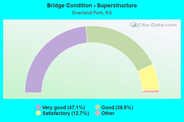
- Bridge Condition - Superstructure
- 47.1%Very good
- 38.9%Good
- 12.7%Satisfactory
- 1.3%Fair
- 0.6%Poor
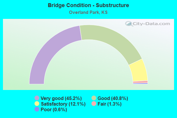
- Bridge Condition - Substructure
- 45.2%Very good
- 40.8%Good
- 12.1%Satisfactory
- 1.3%Fair
- 0.6%Poor
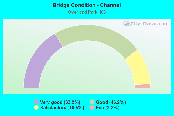
- Bridge Condition - Channel
- 33.2%Very good
- 46.2%Good
- 18.5%Satisfactory
- 2.2%Fair

- Bridge Condition - Culverts
- 19.4%Very good
- 63.4%Good
- 14.0%Satisfactory
- 2.2%Fair
- 1.1%Poor
Find on map >> Show street view
Structure Number: 999906900460951, Location: 4.02 MI N MIAMI COLN (Lat: 38.796111, Lng: -94.676111), Route carried "on" structure: ServiceCity street 853, Year Built: 1967, Year Reconstructed: 2014, Status: Open, Structure Length: 7.38m (24.21ft), Average Daily Traffic: 881 (year 2020), Truck Traffic: 1%, Average Future Daily Traffic: 20,483 (year 2041), Design Load: HS 20, Features Intersected: US69 HWY, NB-SB, Facility Carried by Structure: 183RD ST
Minimum Vertical Clearance: 30.47m (99.97ft), Kilometerpoint: 4.849, Lanes on structure: 2, Lanes under structure: 4, Owner: State Highway Agency, Approaching Roadway Width: 8.5m (27.9ft), Material/Design: Concrete continuous, Design/Construction: Box Beam or Girders - Multiple, Number Of Spans In Main Unit: 4, Length of Maximum Span: 20.7m (67.9ft), Curb-To-Curb Width: 8.5m (27.9ft), Out-to-Out Width: 8.9m (29.2ft)
Condition: Deck: Satisfactory, Superstructure: Good, Substructure: Good, Operating Rating: 82.6 metric tons, Method Used To Determine Operating Rating: Load Factor (LF), Inventory Rating: 49.5 metric tons, Method Used To Determine Inventory Rating: Load Factor (LF), Structural Evaluation: Better than present minimum criteria, Deck Geometry: Somewhat better than minimum adequacy, Underclear: Somewhat better than minimum adequacy, Approach Roadway Alignment: Meets minimum limits, Length Of Structure Improvement: 24.20m (79.40ft), Designated Inspection Frequency: Every 24 months, Inspection Date: May 2020, Deck Structure Type: Concrete Cast-file-Place, Wearing Surface/Protective System: Wearing Surface: Bituminous
Find on map >> Show street view
Structure Number: 999906900460961, Location: 4.53 MI N MIAMI COLN, SB (Lat: 38.803333, Lng: -94.675278), Route carried "on" structure: US 69, Year Built: 1966, Status: Open, Structure Length: 3.44m (11.29ft), Average Daily Traffic: 12,427 (year 2020), Truck Traffic: 9%, Average Future Daily Traffic: 20,363 (year 2041), Design Load: HS 20, Features Intersected: W 179TH ST
Minimum Vertical Clearance: 30.47m (99.97ft), Kilometerpoint: 7.277, Lanes on structure: 2, Lanes under structure: 2, Base Highway Network: Yes, Owner: State Highway Agency, Approaching Roadway Width: 12.2m (40.0ft), Material/Design: Concrete continuous, Design/Construction: Slab, Number Of Spans In Main Unit: 3, Length of Maximum Span: 13.4m (44.0ft), Curb-To-Curb Width: 12.2m (40.0ft), Out-to-Out Width: 12.8m (42.0ft)
Condition: Deck: Fair, Superstructure: Satisfactory, Substructure: Good, Operating Rating: 54.4 metric tons, Method Used To Determine Operating Rating: Load Factor (LF), Inventory Rating: 33.6 metric tons, Method Used To Determine Inventory Rating: Load Factor (LF), Structural Evaluation: Equal to present minimum criteria, Deck Geometry: Better than present minimum criteria, Underclear: Better than present minimum criteria, Approach Roadway Alignment: Equal to present desirable criteria, Length Of Structure Improvement: 11.30m (37.07ft), Designated Inspection Frequency: Every 24 months, Inspection Date: May 2020, Deck Structure Type: Concrete Cast-file-Place, Wearing Surface/Protective System: Wearing Surface: Monolithic Concrete
Find on map >> Show street view
Structure Number: 999906900460971, Location: 4.52 MI N MIAMI COLN, NB (Lat: 38.803611, Lng: -94.675000), Route carried "on" structure: US 69, Year Built: 1966, Status: Open, Structure Length: 3.44m (11.29ft), Average Daily Traffic: 12,427 (year 2020), Truck Traffic: 9%, Average Future Daily Traffic: 20,363 (year 2041), Design Load: HS 20, Features Intersected: W 179TH ST
Minimum Vertical Clearance: 30.47m (99.97ft), Kilometerpoint: 7.277, Lanes on structure: 2, Lanes under structure: 2, Base Highway Network: Yes, Owner: State Highway Agency, Approaching Roadway Width: 12.2m (40.0ft), Material/Design: Concrete continuous, Design/Construction: Slab, Number Of Spans In Main Unit: 3, Length of Maximum Span: 13.4m (44.0ft), Curb-To-Curb Width: 12.2m (40.0ft), Out-to-Out Width: 12.8m (42.0ft)
Condition: Deck: Fair, Superstructure: Satisfactory, Substructure: Good, Operating Rating: 54.4 metric tons, Method Used To Determine Operating Rating: Load Factor (LF), Inventory Rating: 32.7 metric tons, Method Used To Determine Inventory Rating: Load Factor (LF), Structural Evaluation: Equal to present minimum criteria, Deck Geometry: Better than present minimum criteria, Underclear: Somewhat better than minimum adequacy, Approach Roadway Alignment: Equal to present desirable criteria, Length Of Structure Improvement: 11.30m (37.07ft), Designated Inspection Frequency: Every 24 months, Inspection Date: May 2020, Deck Structure Type: Concrete Cast-file-Place, Wearing Surface/Protective System: Wearing Surface: Monolithic Concrete
Find on map >> Show street view
Structure Number: 999906900460981, Location: 5.13 MI N MIAMI COLN, SB (Lat: 38.812222, Lng: -94.675556), Route carried "on" structure: US 69, Year Built: 1966, Status: Open, Structure Length: 7.50m (24.61ft), Average Daily Traffic: 16,819 (year 2020), Truck Traffic: 7%, Average Future Daily Traffic: 27,560 (year 2041), Design Load: HS 20, Features Intersected: BLUE RIVER
Minimum Vertical Clearance: 30.47m (99.97ft), Kilometerpoint: 8.235, Lanes on structure: 2, Base Highway Network: Yes, Owner: State Highway Agency, Approaching Roadway Width: 12.2m (40.0ft), Material/Design: Concrete continuous, Design/Construction: Box Beam or Girders - Multiple, Number Of Spans In Main Unit: 3, Length of Maximum Span: 29.6m (97.1ft), Curb-To-Curb Width: 12.2m (40.0ft), Out-to-Out Width: 12.8m (42.0ft)
Condition: Deck: Good, Superstructure: Good, Substructure: Good, Channel: Good, Operating Rating: 76.3 metric tons, Method Used To Determine Operating Rating: Load Factor (LF), Inventory Rating: 45.7 metric tons, Method Used To Determine Inventory Rating: Load Factor (LF), Structural Evaluation: Better than present minimum criteria, Deck Geometry: Better than present minimum criteria, Waterway Adequacy: Better than present minimum criteria, Approach Roadway Alignment: Equal to present desirable criteria, Length Of Structure Improvement: 24.60m (80.71ft), Designated Inspection Frequency: Every 24 months, Inspection Date: May 2020, Deck Structure Type: Concrete Cast-file-Place, Wearing Surface/Protective System: Wearing Surface: Low Slump Concrete
Find on map >> Show street view
Structure Number: 999906900461001, Location: 4.03 MI S 135 TH STREET (Lat: 38.825278, Lng: -94.676667), Route carried "on" structure: US 69, Year Built: 1966, Status: Open, Structure Length: 3.14m (10.30ft), Average Daily Traffic: 16,819 (year 2020), Truck Traffic: 7%, Average Future Daily Traffic: 27,560 (year 2041), Design Load: HS 20, Features Intersected: 167TH ST
Minimum Vertical Clearance: 30.47m (99.97ft), Kilometerpoint: 9.711, Lanes on structure: 2, Lanes under structure: 2, Base Highway Network: Yes, Owner: State Highway Agency, Approaching Roadway Width: 12.2m (40.0ft), Skew: 1 degrees, Material/Design: Concrete continuous, Design/Construction: Slab, Number Of Spans In Main Unit: 3, Length of Maximum Span: 12.2m (40.0ft), Curb-To-Curb Width: 12.2m (40.0ft), Out-to-Out Width: 12.8m (42.0ft)
Condition: Deck: Satisfactory, Superstructure: Satisfactory, Substructure: Good, Operating Rating: 56.2 metric tons, Method Used To Determine Operating Rating: Load Factor (LF), Inventory Rating: 33.6 metric tons, Method Used To Determine Inventory Rating: Load Factor (LF), Structural Evaluation: Equal to present minimum criteria, Deck Geometry: Better than present minimum criteria, Underclear: Meets minimum limits, Approach Roadway Alignment: Equal to present desirable criteria, Length Of Structure Improvement: 10.30m (33.79ft), Designated Inspection Frequency: Every 24 months, Inspection Date: May 2020, Deck Structure Type: Concrete Cast-file-Place, Wearing Surface/Protective System: Wearing Surface: Bituminous
Find on map >> Show street view
Structure Number: 999906900461011, Location: 4.04 MI S 135 TH STREET (Lat: 38.825278, Lng: -94.676389), Route carried "on" structure: US 69, Year Built: 1966, Status: Open, Structure Length: 3.14m (10.30ft), Average Daily Traffic: 16,819 (year 2020), Truck Traffic: 7%, Average Future Daily Traffic: 27,560 (year 2041), Design Load: HS 20, Features Intersected: 167TH ST
Minimum Vertical Clearance: 30.47m (99.97ft), Kilometerpoint: 9.711, Lanes on structure: 2, Lanes under structure: 2, Base Highway Network: Yes, Owner: State Highway Agency, Approaching Roadway Width: 12.2m (40.0ft), Skew: 1 degrees, Material/Design: Concrete continuous, Design/Construction: Slab, Number Of Spans In Main Unit: 3, Length of Maximum Span: 12.2m (40.0ft), Curb-To-Curb Width: 12.2m (40.0ft), Out-to-Out Width: 12.8m (42.0ft)
Condition: Deck: Satisfactory, Superstructure: Good, Substructure: Satisfactory, Operating Rating: 56.2 metric tons, Method Used To Determine Operating Rating: Load Factor (LF), Inventory Rating: 33.6 metric tons, Method Used To Determine Inventory Rating: Load Factor (LF), Structural Evaluation: Equal to present minimum criteria, Deck Geometry: Better than present minimum criteria, Underclear: Meets minimum limits, Approach Roadway Alignment: Equal to present desirable criteria, Length Of Structure Improvement: 10.30m (33.79ft), Designated Inspection Frequency: Every 24 months, Inspection Date: May 2020, Deck Structure Type: Concrete Cast-file-Place, Wearing Surface/Protective System: Wearing Surface: Bituminous
Find on map >> Show street view
Structure Number: 999906900461031, Location: 8.05 MI N MIAMI COLN SB (Lat: 38.854444, Lng: -94.677222), Route carried "on" structure: US 69, Year Built: 1966, Year Reconstructed: 2020, Status: Open, Structure Length: 5.21m (17.09ft), Average Daily Traffic: 20,860 (year 2020), Truck Traffic: 6%, Average Future Daily Traffic: 34,182 (year 2041), Design Load: HS 20, Features Intersected: 151ST ST
Minimum Vertical Clearance: 30.47m (99.97ft), Kilometerpoint: 12.946, Lanes on structure: 2, Lanes under structure: 8, Base Highway Network: Yes, Owner: State Highway Agency, Approaching Roadway Width: 12.2m (40.0ft), Material/Design: Concrete continuous, Design/Construction: Slab, Number Of Spans In Main Unit: 4, Length of Maximum Span: 14.6m (47.9ft), Curb-To-Curb Width: 12.2m (40.0ft), Out-to-Out Width: 12.8m (42.0ft)
Condition: Deck: Good, Superstructure: Good, Substructure: Good, Operating Rating: 56.2 metric tons, Method Used To Determine Operating Rating: Load Factor (LF), Inventory Rating: 33.6 metric tons, Method Used To Determine Inventory Rating: Load Factor (LF), Structural Evaluation: Better than present minimum criteria, Deck Geometry: Better than present minimum criteria, Underclear: High priority of corrective action, Approach Roadway Alignment: Equal to present desirable criteria, Length Of Structure Improvement: 17.10m (56.10ft), Designated Inspection Frequency: Every 24 months, Inspection Date: May 2020, Deck Structure Type: Concrete Cast-file-Place, Wearing Surface/Protective System: Wearing Surface: Low Slump Concrete
Find on map >> Show street view
Structure Number: 999906900461041, Location: 8.06 MI N MIAMI COLN, NB (Lat: 38.854444, Lng: -94.676944), Route carried "on" structure: US 69, Year Built: 1966, Status: Open, Structure Length: 5.21m (17.09ft), Average Daily Traffic: 20,860 (year 2020), Truck Traffic: 6%, Average Future Daily Traffic: 34,182 (year 2041), Design Load: HS 20, Features Intersected: RS1774, 151ST ST
Minimum Vertical Clearance: 30.47m (99.97ft), Kilometerpoint: 12.947, Lanes on structure: 2, Lanes under structure: 8, Base Highway Network: Yes, Owner: State Highway Agency, Approaching Roadway Width: 12.2m (40.0ft), Material/Design: Concrete continuous, Design/Construction: Slab, Number Of Spans In Main Unit: 4, Length of Maximum Span: 14.6m (47.9ft), Curb-To-Curb Width: 12.2m (40.0ft), Out-to-Out Width: 12.8m (42.0ft)
Condition: Deck: Good, Superstructure: Good, Substructure: Good, Operating Rating: 56.2 metric tons, Method Used To Determine Operating Rating: Load Factor (LF), Inventory Rating: 33.6 metric tons, Method Used To Determine Inventory Rating: Load Factor (LF), Structural Evaluation: Better than present minimum criteria, Deck Geometry: Better than present minimum criteria, Underclear: Better than present minimum criteria, Approach Roadway Alignment: Equal to present desirable criteria, Length Of Structure Improvement: 17.10m (56.10ft), Designated Inspection Frequency: Every 24 months, Inspection Date: May 2020, Deck Structure Type: Concrete Cast-file-Place, Wearing Surface/Protective System: Wearing Surface: Low Slump Concrete
Find on map >> Show street view
Structure Number: 999906900461071, Location: 0.50 MI S 135 TH STREET (Lat: 38.876389, Lng: -94.676111), Route carried "on" structure: US 69, Year Built: 1966, Status: Open, Structure Length: 0.85m (2.79ft), Average Daily Traffic: 30,275 (year 2020), Truck Traffic: 6%, Average Future Daily Traffic: 49,609 (year 2041), Design Load: HS 20, Features Intersected: 139TH STREET
Minimum Vertical Clearance: 30.47m (99.97ft), Kilometerpoint: 15.392, Lanes on structure: 4, Lanes under structure: 2, Base Highway Network: Yes, Owner: State Highway Agency, Approaching Roadway Width: 24.4m (80.1ft), Skew: 20 degrees, Material/Design: Concrete, Design/Construction: Culvert, Number Of Spans In Main Unit: 1, Length of Maximum Span: 8.5m (27.9ft), Curb-To-Curb Width: 38.9m (127.6ft), Out-to-Out Width: 39.7m (130.2ft)
Condition: Culverts: Satisfactory, Operating Rating: 82.8 metric tons, Method Used To Determine Operating Rating: Load Factor (LF), Inventory Rating: 49.6 metric tons, Method Used To Determine Inventory Rating: Load Factor (LF), Structural Evaluation: Equal to present minimum criteria, Deck Geometry: Superior to present desirable criteria, Underclear: High priority of corrective action, Approach Roadway Alignment: Equal to present desirable criteria, Length Of Structure Improvement: 2.80m (9.19ft), Designated Inspection Frequency: Every 24 months, Inspection Date: May 2020, Deck Structure Type: Concrete Cast-file-Place, Wearing Surface/Protective System: Wearing Surface: Bituminous
Find on map >> Show street view
Structure Number: 999906900461081, Location: 4.27 MI S I435 (Lat: 38.882778, Lng: -94.677778), Route carried "on" structure: Ramp State highway 39, Year Built: 1966, Status: Open, Structure Length: 4.66m (15.29ft), Average Daily Traffic: 6,040 (year 2020), Truck Traffic: 5%, Average Future Daily Traffic: 47,692 (year 2041), Design Load: HS 20, Features Intersected: TOMAHAWK CR & PED PASS, Facility Carried by Structure: US69 WL ENT RMP
Minimum Vertical Clearance: 30.47m (99.97ft), Kilometerpoint: 0.090, Lanes on structure: 1, Base Highway Network: Yes (Inventory Route: 4640039, Subroute: 4), Owner: State Highway Agency, Approaching Roadway Width: 9.1m (29.9ft), Material/Design: Concrete continuous, Design/Construction: Slab, Number Of Spans In Main Unit: 3, Length of Maximum Span: 18.3m (60.0ft), Curb-To-Curb Width: 9.1m (29.9ft), Out-to-Out Width: 9.7m (31.8ft)
Condition: Deck: Satisfactory, Superstructure: Good, Substructure: Good, Channel: Good, Operating Rating: 62.6 metric tons, Method Used To Determine Operating Rating: Load Factor (LF), Inventory Rating: 37.2 metric tons, Method Used To Determine Inventory Rating: Load Factor (LF), Structural Evaluation: Better than present minimum criteria, Deck Geometry: Superior to present desirable criteria, Waterway Adequacy: Equal to present desirable criteria, Approach Roadway Alignment: Better than present minimum criteria, Length Of Structure Improvement: 15.30m (50.20ft), Designated Inspection Frequency: Every 24 months, Inspection Date: May 2020, Deck Structure Type: Concrete Cast-file-Place, Wearing Surface/Protective System: Wearing Surface: Low Slump Concrete
Find on map >> Show street view
Structure Number: 999906900461091, Location: 4.18 MI S I435 (Lat: 38.883611, Lng: -94.676389), Route carried "on" structure: US 69, Year Built: 1966, Status: Open, Structure Length: 5.21m (17.09ft), Average Daily Traffic: 30,275 (year 2020), Truck Traffic: 6%, Average Future Daily Traffic: 49,609 (year 2041), Design Load: HS 20, Features Intersected: 135 TH STREET
Minimum Vertical Clearance: 30.47m (99.97ft), Kilometerpoint: 16.193, Lanes on structure: 2, Lanes under structure: 6, Base Highway Network: Yes, Owner: State Highway Agency, Approaching Roadway Width: 12.2m (40.0ft), Material/Design: Concrete continuous, Design/Construction: Slab, Number Of Spans In Main Unit: 4, Length of Maximum Span: 14.6m (47.9ft), Curb-To-Curb Width: 12.2m (40.0ft), Out-to-Out Width: 12.8m (42.0ft)
Condition: Deck: Good, Superstructure: Good, Substructure: Satisfactory, Operating Rating: 54.4 metric tons, Method Used To Determine Operating Rating: Load Factor (LF), Inventory Rating: 32.7 metric tons, Method Used To Determine Inventory Rating: Load Factor (LF), Structural Evaluation: Equal to present minimum criteria, Deck Geometry: Better than present minimum criteria, Underclear: Equal to present minimum criteria, Approach Roadway Alignment: Equal to present desirable criteria, Length Of Structure Improvement: 17.10m (56.10ft), Designated Inspection Frequency: Every 24 months, Inspection Date: May 2020, Deck Structure Type: Concrete Cast-file-Place, Wearing Surface/Protective System: Wearing Surface: Low Slump Concrete
Find on map >> Show street view
Structure Number: 999906900461101, Location: 4.17 MI S I435 (Lat: 38.883611, Lng: -94.676111), Route carried "on" structure: US 69, Year Built: 1966, Status: Open, Structure Length: 5.21m (17.09ft), Average Daily Traffic: 30,275 (year 2020), Truck Traffic: 6%, Average Future Daily Traffic: 49,609 (year 2041), Design Load: HS 20, Features Intersected: 135 TH STREET
Minimum Vertical Clearance: 30.47m (99.97ft), Kilometerpoint: 16.195, Lanes on structure: 3, Lanes under structure: 6, Base Highway Network: Yes, Owner: State Highway Agency, Approaching Roadway Width: 14.6m (47.9ft), Material/Design: Concrete continuous, Design/Construction: Slab, Number Of Spans In Main Unit: 4, Length of Maximum Span: 14.6m (47.9ft), Curb-To-Curb Width: 12.2m (40.0ft), Out-to-Out Width: 12.8m (42.0ft)
Condition: Deck: Satisfactory, Superstructure: Good, Substructure: Good, Operating Rating: 54.4 metric tons, Method Used To Determine Operating Rating: Load Factor (LF), Inventory Rating: 32.7 metric tons, Method Used To Determine Inventory Rating: Load Factor (LF), Structural Evaluation: Better than present minimum criteria, Deck Geometry: High priority of replacement, Underclear: Equal to present minimum criteria, Approach Roadway Alignment: Better than present minimum criteria, Length Of Structure Improvement: 17.10m (56.10ft), Designated Inspection Frequency: Every 24 months, Inspection Date: May 2020, Deck Structure Type: Concrete Cast-file-Place, Wearing Surface/Protective System: Wearing Surface: Low Slump Concrete
Find on map >> Show street view
Structure Number: 999906900461111, Location: 4.12 MI S I435 (Lat: 38.884444, Lng: -94.676389), Route carried "on" structure: US 69, Year Built: 1966, Status: Open, Structure Length: 6.19m (20.31ft), Average Daily Traffic: 30,275 (year 2020), Truck Traffic: 6%, Average Future Daily Traffic: 49,609 (year 2041), Design Load: HS 20, Features Intersected: TOMAHAWK CR & PED PASS
Minimum Vertical Clearance: 30.47m (99.97ft), Kilometerpoint: 16.296, Lanes on structure: 2, Base Highway Network: Yes, Owner: State Highway Agency, Approaching Roadway Width: 12.2m (40.0ft), Material/Design: Concrete continuous, Design/Construction: Box Beam or Girders - Multiple, Number Of Spans In Main Unit: 3, Length of Maximum Span: 24.4m (80.1ft), Curb-To-Curb Width: 14.6m (47.9ft), Out-to-Out Width: 15.2m (49.9ft)
Condition: Deck: Good, Superstructure: Good, Substructure: Good, Channel: Good, Operating Rating: 77.0 metric tons, Method Used To Determine Operating Rating: Load Factor (LF), Inventory Rating: 46.1 metric tons, Method Used To Determine Inventory Rating: Load Factor (LF), Structural Evaluation: Better than present minimum criteria, Deck Geometry: Superior to present desirable criteria, Waterway Adequacy: Equal to present minimum criteria, Approach Roadway Alignment: Equal to present desirable criteria, Length Of Structure Improvement: 20.30m (66.60ft), Designated Inspection Frequency: Every 24 months, Inspection Date: May 2020, Deck Structure Type: Concrete Cast-file-Place, Wearing Surface/Protective System: Wearing Surface: Low Slump Concrete
Find on map >> Show street view
Structure Number: 999906900461121, Location: 4.11 MI S I435 (Lat: 38.884444, Lng: -94.676111), Route carried "on" structure: US 69, Year Built: 1966, Status: Open, Structure Length: 6.19m (20.31ft), Average Daily Traffic: 30,275 (year 2020), Truck Traffic: 6%, Average Future Daily Traffic: 49,609 (year 2041), Design Load: HS 20, Features Intersected: TOMAHAWK CR & PED PASS
Minimum Vertical Clearance: 30.47m (99.97ft), Kilometerpoint: 16.296, Lanes on structure: 3, Base Highway Network: Yes, Owner: State Highway Agency, Approaching Roadway Width: 14.6m (47.9ft), Material/Design: Concrete continuous, Design/Construction: Box Beam or Girders - Multiple, Number Of Spans In Main Unit: 3, Length of Maximum Span: 24.4m (80.1ft), Curb-To-Curb Width: 14.6m (47.9ft), Out-to-Out Width: 15.2m (49.9ft)
Condition: Deck: Satisfactory, Superstructure: Good, Substructure: Good, Channel: Good, Operating Rating: 78.2 metric tons, Method Used To Determine Operating Rating: Load Factor (LF), Inventory Rating: 46.9 metric tons, Method Used To Determine Inventory Rating: Load Factor (LF), Structural Evaluation: Better than present minimum criteria, Deck Geometry: Meets minimum limits, Waterway Adequacy: Equal to present desirable criteria, Approach Roadway Alignment: Better than present minimum criteria, Length Of Structure Improvement: 20.30m (66.60ft), Designated Inspection Frequency: Every 24 months, Inspection Date: May 2020, Deck Structure Type: Concrete Cast-file-Place, Wearing Surface/Protective System: Wearing Surface: Low Slump Concrete
Find on map >> Show street view
Structure Number: 999906900461131, Location: 4.12 MI S I435 (Lat: 38.885000, Lng: -94.677222), Route carried "on" structure: Ramp State highway 39, Year Built: 1966, Year Reconstructed: 1991, Status: Open, Structure Length: 1.64m (5.38ft), Average Daily Traffic: 22,805 (year 2020), Truck Traffic: 5%, Average Future Daily Traffic: 47,692 (year 2041), Design Load: H 20, Features Intersected: TOMAHAWK CREEK DRAINAGE, Facility Carried by Structure: US69 WL EXIT RAMP
Minimum Vertical Clearance: 30.47m (99.97ft), Kilometerpoint: 0.249, Lanes on structure: 4, Base Highway Network: Yes (Inventory Route: 4640039, Subroute: 3), Owner: State Highway Agency, Approaching Roadway Width: 9.1m (29.9ft), Skew: 3 degrees, Material/Design: Concrete, Design/Construction: Culvert, Number Of Spans In Main Unit: 2, Number Of Approach Spans: 2, Length of Maximum Span: 3.7m (12.1ft), Curb-To-Curb Width: 10.1m (33.1ft), Out-to-Out Width: 19.0m (62.3ft)
Condition: Channel: Good, Culverts: Good, Operating Rating: 55.2 metric tons, Method Used To Determine Operating Rating: Load Factor (LF), Inventory Rating: 33.1 metric tons, Method Used To Determine Inventory Rating: Load Factor (LF), Structural Evaluation: Better than present minimum criteria, Deck Geometry: High priority of replacement, Waterway Adequacy: Somewhat better than minimum adequacy, Approach Roadway Alignment: Equal to present desirable criteria, Length Of Structure Improvement: 5.43m (17.81ft), Designated Inspection Frequency: Every 24 months, Inspection Date: May 2020, Deck Structure Type: Concrete Cast-file-Place, Wearing Surface/Protective System: Wearing Surface: Monolithic Concrete
Find on map >> Show street view
Structure Number: 999906900461141, Location: 3.08 MI S I435 (Lat: 38.900278, Lng: -94.676944), Route carried "on" structure: City street 4261, Year Built: 1966, Status: Open, Structure Length: 7.31m (23.98ft), Average Daily Traffic: 11,774 (year 2020), Truck Traffic: 6%, Average Future Daily Traffic: 13,009 (year 2041), Design Load: HS 20, Features Intersected: NB US 69 HWY, Facility Carried by Structure: SB Bl Valley Pkwy
Minimum Vertical Clearance: 30.47m (99.97ft), Kilometerpoint: 0.583, Lanes on structure: 2, Lanes under structure: 2, Owner: State Highway Agency, Approaching Roadway Width: 12.2m (40.0ft), Material/Design: Concrete continuous, Design/Construction: Box Beam or Girders - Multiple, Number Of Spans In Main Unit: 3, Length of Maximum Span: 29.0m (95.1ft), Curb-To-Curb Width: 12.2m (40.0ft), Out-to-Out Width: 12.7m (41.7ft)
Condition: Deck: Satisfactory, Superstructure: Satisfactory, Substructure: Good, Operating Rating: 75.7 metric tons, Method Used To Determine Operating Rating: Load Factor (LF), Inventory Rating: 45.4 metric tons, Method Used To Determine Inventory Rating: Load Factor (LF), Structural Evaluation: Equal to present minimum criteria, Deck Geometry: Somewhat better than minimum adequacy, Underclear: Somewhat better than minimum adequacy, Approach Roadway Alignment: Somewhat better than minimum adequacy, Length Of Structure Improvement: 24.00m (78.74ft), Designated Inspection Frequency: Every 24 months, Inspection Date: May 2020, Deck Structure Type: Concrete Cast-file-Place, Wearing Surface/Protective System: Wearing Surface: Low Slump Concrete
Find on map >> Show street view
Structure Number: 999906900461221, Location: 2.46 MI S I435 (Lat: 38.905278, Lng: -94.686389), Route carried "on" structure: City street 2901, Year Built: 1973, Status: Open, Structure Length: 8.53m (27.99ft), Average Daily Traffic: 9,046 (year 2020), Truck Traffic: 7%, Average Future Daily Traffic: 18,457 (year 2041), Design Load: HS 20, Features Intersected: US 69 HWY, Facility Carried by Structure: RD SB ANTIOCH
Minimum Vertical Clearance: 30.47m (99.97ft), Kilometerpoint: 8.876, Lanes on structure: 2, Lanes under structure: 4, Owner: State Highway Agency, Approaching Roadway Width: 8.5m (27.9ft), Skew: 22 degrees, Material/Design: Steel continuous, Design/Construction: Stringer/Multi-beam, Number Of Spans In Main Unit: 4, Length of Maximum Span: 25.6m (84.0ft), Curb or Sidewalk Widths: Left: 1.2m (3.9ft), Right: 0.0m, Curb-To-Curb Width: 8.2m (26.9ft), Out-to-Out Width: 13.8m (45.3ft)
Condition: Deck: Good, Superstructure: Satisfactory, Substructure: Satisfactory, Operating Rating: 53.5 metric tons, Method Used To Determine Operating Rating: Load Factor (LF), Inventory Rating: 31.8 metric tons, Method Used To Determine Inventory Rating: Load Factor (LF), Structural Evaluation: Equal to present minimum criteria, Deck Geometry: High priority of corrective action, Underclear: Somewhat better than minimum adequacy, Approach Roadway Alignment: Somewhat better than minimum adequacy, Length Of Structure Improvement: 27.98m (91.80ft), Designated Inspection Frequency: Every 24 months, Inspection Date: May 2020, Deck Structure Type: Concrete Cast-file-Place, Wearing Surface/Protective System: Wearing Surface: Low Slump Concrete
Find on map >> Show street view
Structure Number: 999906900461231, Location: 1.61 MI S I435 (Lat: 38.912778, Lng: -94.698611), Route carried "on" structure: US 69, Year Built: 1973, Year Reconstructed: 2011, Status: Open, Structure Length: 6.52m (21.39ft), Average Daily Traffic: 33,639 (year 2020), Truck Traffic: 6%, Average Future Daily Traffic: 55,121 (year 2041), Design Load: HS 20, Features Intersected: 119TH STREET
Minimum Vertical Clearance: 30.47m (99.97ft), Kilometerpoint: 20.323, Lanes on structure: 3, Lanes under structure: 7, Base Highway Network: Yes, Owner: State Highway Agency, Approaching Roadway Width: 15.8m (51.8ft), Skew: 3 degrees, Material/Design: Concrete continuous, Design/Construction: Slab, Number Of Spans In Main Unit: 4, Length of Maximum Span: 18.3m (60.0ft), Curb-To-Curb Width: 15.8m (51.8ft), Out-to-Out Width: 15.8m (51.8ft)
Condition: Deck: Good, Superstructure: Good, Substructure: Good, Operating Rating: 68.0 metric tons, Method Used To Determine Operating Rating: Load Factor (LF), Inventory Rating: 40.8 metric tons, Method Used To Determine Inventory Rating: Load Factor (LF), Structural Evaluation: Better than present minimum criteria, Deck Geometry: Somewhat better than minimum adequacy, Underclear: High priority of corrective action, Approach Roadway Alignment: Equal to present desirable criteria, Length Of Structure Improvement: 21.39m (70.18ft), Designated Inspection Frequency: Every 24 months, Inspection Date: May 2020, Deck Structure Type: Concrete Cast-file-Place, Wearing Surface/Protective System: Wearing Surface: Epoxy Overlay
Find on map >> Show street view
Structure Number: 999906900461241, Location: 1.62 MI S I435 (Lat: 38.912778, Lng: -94.698333), Route carried "on" structure: US 69, Year Built: 1973, Status: Open, Structure Length: 6.52m (21.39ft), Average Daily Traffic: 33,639 (year 2020), Truck Traffic: 6%, Average Future Daily Traffic: 55,121 (year 2041), Design Load: HS 20, Features Intersected: 119TH STREET
Minimum Vertical Clearance: 30.47m (99.97ft), Kilometerpoint: 20.411, Lanes on structure: 2, Lanes under structure: 7, Base Highway Network: Yes, Owner: State Highway Agency, Approaching Roadway Width: 12.2m (40.0ft), Skew: 3 degrees, Material/Design: Concrete continuous, Design/Construction: Slab, Number Of Spans In Main Unit: 4, Length of Maximum Span: 18.3m (60.0ft), Curb-To-Curb Width: 12.2m (40.0ft), Out-to-Out Width: 12.8m (42.0ft)
Condition: Deck: Satisfactory, Superstructure: Good, Substructure: Good, Operating Rating: 68.0 metric tons, Method Used To Determine Operating Rating: Load Factor (LF), Inventory Rating: 40.8 metric tons, Method Used To Determine Inventory Rating: Load Factor (LF), Structural Evaluation: Better than present minimum criteria, Deck Geometry: Better than present minimum criteria, Underclear: Somewhat better than minimum adequacy, Approach Roadway Alignment: Somewhat better than minimum adequacy, Length Of Structure Improvement: 21.39m (70.18ft), Designated Inspection Frequency: Every 24 months, Inspection Date: May 2020, Deck Structure Type: Concrete Cast-file-Place, Wearing Surface/Protective System: Wearing Surface: Low Slump Concrete
Find on map >> Show street view
Structure Number: 999906900461251, Location: 1.17MI S I435 (Lat: 38.920278, Lng: -94.703889), Route carried "on" structure: US 69, Year Built: 1973, Status: Open, Structure Length: 4.67m (15.32ft), Average Daily Traffic: 44,701 (year 2020), Truck Traffic: 5%, Average Future Daily Traffic: 73,248 (year 2041), Design Load: HS 20, Features Intersected: INDIAN CR & PED PASS
Minimum Vertical Clearance: 30.47m (99.97ft), Kilometerpoint: 21.274, Lanes on structure: 2, Base Highway Network: Yes, Owner: State Highway Agency, Approaching Roadway Width: 12.2m (40.0ft), Skew: 1 degrees, Material/Design: Concrete continuous, Design/Construction: Slab, Number Of Spans In Main Unit: 3, Length of Maximum Span: 18.3m (60.0ft), Curb-To-Curb Width: 12.2m (40.0ft), Out-to-Out Width: 12.8m (42.0ft)
Condition: Deck: Good, Superstructure: Good, Substructure: Very good, Channel: Very good, Operating Rating: 62.6 metric tons, Method Used To Determine Operating Rating: Load Factor (LF), Inventory Rating: 37.2 metric tons, Method Used To Determine Inventory Rating: Load Factor (LF), Structural Evaluation: Better than present minimum criteria, Deck Geometry: Better than present minimum criteria, Waterway Adequacy: Equal to present desirable criteria, Approach Roadway Alignment: Equal to present desirable criteria, Length Of Structure Improvement: 15.31m (50.23ft), Designated Inspection Frequency: Every 24 months, Inspection Date: May 2020, Deck Structure Type: Concrete Cast-file-Place, Wearing Surface/Protective System: Wearing Surface: Low Slump Concrete
Find on map >> Show street view
Structure Number: 999906900461261, Location: 1.16MI S I435 (Lat: 38.920278, Lng: -94.703611), Route carried "on" structure: US 69, Year Built: 1973, Status: Open, Structure Length: 4.67m (15.32ft), Average Daily Traffic: 44,701 (year 2020), Truck Traffic: 5%, Average Future Daily Traffic: 73,248 (year 2041), Design Load: HS 20, Features Intersected: INDIAN CR & PED PASS
Minimum Vertical Clearance: 30.47m (99.97ft), Kilometerpoint: 21.366, Lanes on structure: 2, Base Highway Network: Yes, Owner: State Highway Agency, Approaching Roadway Width: 12.2m (40.0ft), Skew: 1 degrees, Material/Design: Concrete continuous, Design/Construction: Slab, Number Of Spans In Main Unit: 3, Length of Maximum Span: 18.3m (60.0ft), Curb-To-Curb Width: 12.2m (40.0ft), Out-to-Out Width: 12.8m (42.0ft)
Condition: Deck: Good, Superstructure: Good, Substructure: Very good, Channel: Good, Operating Rating: 62.6 metric tons, Method Used To Determine Operating Rating: Load Factor (LF), Inventory Rating: 37.2 metric tons, Method Used To Determine Inventory Rating: Load Factor (LF), Structural Evaluation: Better than present minimum criteria, Deck Geometry: Better than present minimum criteria, Waterway Adequacy: Equal to present desirable criteria, Approach Roadway Alignment: Better than present minimum criteria, Length Of Structure Improvement: 15.31m (50.23ft), Designated Inspection Frequency: Every 24 months, Inspection Date: May 2020, Deck Structure Type: Concrete Cast-file-Place, Wearing Surface/Protective System: Wearing Surface: Low Slump Concrete
Find on map >> Show street view
Structure Number: 999906900461271, Location: 0.68MI SOF I435 (Lat: 38.927222, Lng: -94.705000), Route carried "on" structure: US 69, Year Built: 1973, Status: Open, Structure Length: 5.21m (17.09ft), Average Daily Traffic: 42,529 (year 2020), Truck Traffic: 5%, Average Future Daily Traffic: 63,196 (year 2041), Design Load: HS 20, Features Intersected: COLLEGE BLVD
Minimum Vertical Clearance: 30.47m (99.97ft), Kilometerpoint: 22.059, Lanes on structure: 3, Lanes under structure: 5, Base Highway Network: Yes, Owner: State Highway Agency, Approaching Roadway Width: 12.2m (40.0ft), Material/Design: Concrete continuous, Design/Construction: Slab, Number Of Spans In Main Unit: 4, Length of Maximum Span: 14.6m (47.9ft), Curb-To-Curb Width: 14.6m (47.9ft), Out-to-Out Width: 15.8m (51.8ft)
Condition: Deck: Satisfactory, Superstructure: Good, Substructure: Good, Operating Rating: 55.3 metric tons, Method Used To Determine Operating Rating: Load Factor (LF), Inventory Rating: 33.6 metric tons, Method Used To Determine Inventory Rating: Load Factor (LF), Structural Evaluation: Better than present minimum criteria, Deck Geometry: Meets minimum limits, Underclear: High priority of corrective action, Approach Roadway Alignment: Equal to present desirable criteria, Length Of Structure Improvement: 17.10m (56.10ft), Designated Inspection Frequency: Every 24 months, Inspection Date: May 2020, Deck Structure Type: Concrete Cast-file-Place, Wearing Surface/Protective System: Wearing Surface: Bituminous
Find on map >> Show street view
Structure Number: 999906900461281, Location: 0.67MI S I435 (Lat: 38.927222, Lng: -94.704722), Route carried "on" structure: US 69, Year Built: 1973, Status: Open, Structure Length: 5.21m (17.09ft), Average Daily Traffic: 42,529 (year 2020), Truck Traffic: 5%, Average Future Daily Traffic: 69,689 (year 2041), Design Load: HS 20, Features Intersected: COLLEGE BLVD
Minimum Vertical Clearance: 30.47m (99.97ft), Kilometerpoint: 22.151, Lanes on structure: 3, Lanes under structure: 5, Base Highway Network: Yes, Owner: State Highway Agency, Approaching Roadway Width: 12.2m (40.0ft), Material/Design: Concrete continuous, Design/Construction: Slab, Number Of Spans In Main Unit: 4, Length of Maximum Span: 14.6m (47.9ft), Curb-To-Curb Width: 14.6m (47.9ft), Out-to-Out Width: 15.2m (49.9ft)
Condition: Deck: Good, Superstructure: Good, Substructure: Good, Operating Rating: 55.3 metric tons, Method Used To Determine Operating Rating: Load Factor (LF), Inventory Rating: 33.6 metric tons, Method Used To Determine Inventory Rating: Load Factor (LF), Structural Evaluation: Better than present minimum criteria, Deck Geometry: Meets minimum limits, Underclear: High priority of corrective action, Approach Roadway Alignment: Equal to present desirable criteria, Length Of Structure Improvement: 17.10m (56.10ft), Designated Inspection Frequency: Every 24 months, Inspection Date: May 2020, Deck Structure Type: Concrete Cast-file-Place, Wearing Surface/Protective System: Wearing Surface: Low Slump Concrete
Find on map >> Show street view
Structure Number: 999906900461301, Location: 0.38 MI S I435 (Lat: 38.929444, Lng: -94.705000), Route carried "on" structure: US 69, Year Built: 1973, Year Reconstructed: 1985, Status: Open, Structure Length: 4.66m (15.29ft), Average Daily Traffic: 42,529 (year 2020), Truck Traffic: 5%, Average Future Daily Traffic: 63,196 (year 2041), Design Load: HS 20, Features Intersected: INDIAN CREEK DRAINAGE
Minimum Vertical Clearance: 30.47m (99.97ft), Kilometerpoint: 22.318, Lanes on structure: 3, Base Highway Network: Yes, Owner: State Highway Agency, Approaching Roadway Width: 18.9m (62.0ft), Material/Design: Concrete continuous, Design/Construction: Slab, Number Of Spans In Main Unit: 3, Length of Maximum Span: 18.3m (60.0ft), Curb-To-Curb Width: 18.9m (62.0ft), Out-to-Out Width: 19.9m (65.3ft)
Condition: Deck: Satisfactory, Superstructure: Good, Substructure: Very good, Channel: Very good, Operating Rating: 62.6 metric tons, Method Used To Determine Operating Rating: Load Factor (LF), Inventory Rating: 37.2 metric tons, Method Used To Determine Inventory Rating: Load Factor (LF), Structural Evaluation: Better than present minimum criteria, Deck Geometry: Superior to present desirable criteria, Waterway Adequacy: Equal to present desirable criteria, Approach Roadway Alignment: Equal to present desirable criteria, Length Of Structure Improvement: 15.30m (50.20ft), Designated Inspection Frequency: Every 24 months, Inspection Date: May 2020, Deck Structure Type: Concrete Cast-file-Place, Wearing Surface/Protective System: Wearing Surface: Bituminous
Find on map >> Show street view
Structure Number: 999906900461311, Location: 0.39 MI S I435 (Lat: 38.929444, Lng: -94.704444), Route carried "on" structure: US 69, Year Built: 1973, Year Reconstructed: 1999, Status: Open, Structure Length: 4.66m (15.29ft), Average Daily Traffic: 42,529 (year 2020), Truck Traffic: 5%, Average Future Daily Traffic: 69,689 (year 2041), Design Load: HS 20, Features Intersected: INDIAN CREEK DRAINAGE
Minimum Vertical Clearance: 30.47m (99.97ft), Kilometerpoint: 22.410, Lanes on structure: 5, Base Highway Network: Yes, Owner: State Highway Agency, Approaching Roadway Width: 18.9m (62.0ft), Material/Design: Concrete continuous, Design/Construction: Slab, Number Of Spans In Main Unit: 3, Length of Maximum Span: 18.3m (60.0ft), Curb-To-Curb Width: 22.6m (74.1ft), Out-to-Out Width: 23.3m (76.4ft)
Condition: Deck: Good, Superstructure: Good, Substructure: Good, Channel: Good, Operating Rating: 62.6 metric tons, Method Used To Determine Operating Rating: Load Factor (LF), Inventory Rating: 37.2 metric tons, Method Used To Determine Inventory Rating: Load Factor (LF), Structural Evaluation: Better than present minimum criteria, Deck Geometry: Meets minimum limits, Waterway Adequacy: Equal to present desirable criteria, Approach Roadway Alignment: Equal to present desirable criteria, Length Of Structure Improvement: 15.30m (50.20ft), Designated Inspection Frequency: Every 24 months, Inspection Date: May 2020, Deck Structure Type: Concrete Cast-file-Place, Wearing Surface/Protective System: Wearing Surface: Low Slump Concrete
Find on map >> Show street view
Structure Number: 999906900461331, Location: 1.54 MI N I435 (Lat: 38.956389, Lng: -94.707778), Route carried "on" structure: City street 2824, Year Built: 1973, Year Reconstructed: 2012, Status: Open, Structure Length: 9.54m (31.30ft), Average Daily Traffic: 21,808 (year 2020), Truck Traffic: 7%, Average Future Daily Traffic: 24,580 (year 2041), Design Load: HS 20, Features Intersected: US 69 HWY
Minimum Vertical Clearance: 30.47m (99.97ft), Kilometerpoint: 15.895, Lanes on structure: 5, Lanes under structure: 8, Owner: State Highway Agency, Approaching Roadway Width: 25.0m (82.0ft), Skew: 23 degrees, Material/Design: Steel continuous, Design/Construction: Stringer/Multi-beam, Number Of Spans In Main Unit: 4, Length of Maximum Span: 29.0m (95.1ft), Curb or Sidewalk Widths: Left: 1.8m (5.9ft), Right: 3.0m (9.8ft), Curb-To-Curb Width: 24.6m (80.7ft), Out-to-Out Width: 31.0m (101.7ft)
Condition: Deck: Good, Superstructure: Very good, Substructure: Good, Operating Rating: 75.3 metric tons, Method Used To Determine Operating Rating: Load Factor (LF), Inventory Rating: 45.4 metric tons, Method Used To Determine Inventory Rating: Load Factor (LF), Structural Evaluation: Better than present minimum criteria, Deck Geometry: Superior to present desirable criteria, Underclear: Equal to present minimum criteria, Approach Roadway Alignment: Somewhat better than minimum adequacy, Length Of Structure Improvement: 31.31m (102.72ft), Designated Inspection Frequency: Every 24 months, Inspection Date: May 2020, Wearing Surface/Protective System: Wearing Surface: Epoxy Overlay, Deck Protection: Epoxy Coated Reinforcing
Find on map >> Show street view
Structure Number: 999906900461341, Location: 2.11 MI N I435 (Lat: 38.963611, Lng: -94.713611), Route carried "on" structure: City street 2912, Year Built: 1973, Year Reconstructed: 2012, Status: Open, Structure Length: 5.69m (18.67ft), Average Daily Traffic: 4,369 (year 2020), Truck Traffic: 5%, Average Future Daily Traffic: 6,001 (year 2041), Design Load: H 20, Features Intersected: US69 HWY, Facility Carried by Structure: LOCAL RD (91ST ST
Minimum Vertical Clearance: 30.47m (99.97ft), Kilometerpoint: 0.858, Lanes on structure: 3, Lanes under structure: 4, Owner: State Highway Agency, Approaching Roadway Width: 10.7m (35.1ft), Material/Design: Steel continuous, Design/Construction: Stringer/Multi-beam, Number Of Spans In Main Unit: 2, Length of Maximum Span: 29.6m (97.1ft), Curb or Sidewalk Widths: Left: 0.0m, Right: 1.5m (4.9ft), Curb-To-Curb Width: 10.7m (35.1ft), Out-to-Out Width: 13.0m (42.7ft)
Condition: Deck: Very good, Superstructure: Good, Substructure: Good, Operating Rating: 66.8 metric tons, Method Used To Determine Operating Rating: Load Factor (LF), Inventory Rating: 39.9 metric tons, Method Used To Determine Inventory Rating: Load Factor (LF), Structural Evaluation: Better than present minimum criteria, Deck Geometry: High priority of replacement, Underclear: Meets minimum limits, Approach Roadway Alignment: Meets minimum limits, Length Of Structure Improvement: 18.68m (61.29ft), Designated Inspection Frequency: Every 24 months, Inspection Date: May 2020, Wearing Surface/Protective System: Wearing Surface: Epoxy Overlay
Find on map >> Show street view
Structure Number: 999906900461371, Location: JCT US69/I435 (Lat: 38.935000, Lng: -94.704722), Route carried "on" structure: US 69, Year Built: 1965, Status: Open, Structure Length: 7.82m (25.66ft), Average Daily Traffic: 42,529 (year 2020), Truck Traffic: 5%, Average Future Daily Traffic: 63,196 (year 2041), Design Load: HS 20, Features Intersected: I435 HWY
Minimum Vertical Clearance: 30.47m (99.97ft), Kilometerpoint: 23.017, Lanes on structure: 3, Lanes under structure: 11, Base Highway Network: Yes, Owner: State Highway Agency, Approaching Roadway Width: 12.5m (41.0ft), Material/Design: Concrete continuous, Design/Construction: Box Beam or Girders - Multiple, Number Of Spans In Main Unit: 4, Length of Maximum Span: 23.2m (76.1ft), Curb-To-Curb Width: 12.5m (41.0ft), Out-to-Out Width: 13.3m (43.6ft)
Condition: Deck: Good, Superstructure: Good, Substructure: Good, Operating Rating: 67.0 metric tons, Method Used To Determine Operating Rating: Load Factor (LF), Inventory Rating: 40.1 metric tons, Method Used To Determine Inventory Rating: Load Factor (LF), Structural Evaluation: Better than present minimum criteria, Deck Geometry: Meets minimum limits, Underclear: Somewhat better than minimum adequacy, Approach Roadway Alignment: Better than present minimum criteria, Length Of Structure Improvement: 25.65m (84.15ft), Designated Inspection Frequency: Every 24 months, Inspection Date: May 2020, Deck Structure Type: Concrete Cast-file-Place, Wearing Surface/Protective System: Wearing Surface: Low Slump Concrete
Find on map >> Show street view
Structure Number: 999906900462561, Location: 0.14 MI S OF I35 (Lat: 39.038611, Lng: -94.670278), Route carried "on" structure: US 69, Year Built: 1986, Status: Open, Structure Length: 5.27m (17.29ft), Average Daily Traffic: 20,153 (year 2020), Truck Traffic: 3%, Average Future Daily Traffic: 25,583 (year 2041), Design Load: HS 20, Features Intersected: TURKEY CREEK
Minimum Vertical Clearance: 30.47m (99.97ft), Kilometerpoint: 37.742, Lanes on structure: 3, Base Highway Network: Yes, Owner: State Highway Agency, Approaching Roadway Width: 15.8m (51.8ft), Material/Design: Prestressed concrete continuous, Design/Construction: Stringer/Multi-beam, Number Of Spans In Main Unit: 3, Length of Maximum Span: 21.3m (69.9ft), Curb-To-Curb Width: 17.4m (57.1ft), Out-to-Out Width: 18.2m (59.7ft)
Condition: Deck: Good, Superstructure: Very good, Substructure: Good, Channel: Good, Operating Rating: 40.8 metric tons, Method Used To Determine Operating Rating: Load Factor (LF), Inventory Rating: 24.5 metric tons, Method Used To Determine Inventory Rating: Load Factor (LF), Structural Evaluation: Equal to present minimum criteria, Deck Geometry: Better than present minimum criteria, Waterway Adequacy: Equal to present minimum criteria, Approach Roadway Alignment: Better than present minimum criteria, Length Of Structure Improvement: 17.29m (56.73ft), Designated Inspection Frequency: Every 24 months, Inspection Date: May 2020, Wearing Surface/Protective System: Wearing Surface: Low Slump Concrete, Deck Protection: Epoxy Coated Reinforcing
Find on map >> Show street view
Structure Number: 999906900462571, Location: JCT EL I35/I635&US69 (Lat: 39.039722, Lng: -94.671111), Route carried "on" structure: US 69, Year Built: 1986, Status: Open, Structure Length: 5.96m (19.55ft), Average Daily Traffic: 20,153 (year 2020), Truck Traffic: 3%, Average Future Daily Traffic: 25,583 (year 2041), Design Load: HS 20, Features Intersected: I35 HWY, NB
Minimum Vertical Clearance: 30.47m (99.97ft), Kilometerpoint: 0.140, Lanes on structure: 2, Lanes under structure: 3, Base Highway Network: Yes (Inventory Route: 4620069, Subroute: 1), Owner: State Highway Agency, Approaching Roadway Width: 12.2m (40.0ft), Material/Design: Steel continuous, Design/Construction: Box Beam or Girders - Multiple, Number Of Spans In Main Unit: 3, Length of Maximum Span: 31.1m (102.0ft), Curb-To-Curb Width: 12.2m (40.0ft), Out-to-Out Width: 13.0m (42.7ft)
Condition: Deck: Good, Superstructure: Good, Substructure: Very good, Operating Rating: 75.3 metric tons, Method Used To Determine Operating Rating: Load Factor (LF), Inventory Rating: 45.4 metric tons, Method Used To Determine Inventory Rating: Load Factor (LF), Structural Evaluation: Better than present minimum criteria, Deck Geometry: Better than present minimum criteria, Underclear: Equal to present minimum criteria, Approach Roadway Alignment: Better than present minimum criteria, Length Of Structure Improvement: 19.55m (64.14ft), Designated Inspection Frequency: Every 24 months, Inspection Date: May 2020, Wearing Surface/Protective System: Wearing Surface: Low Slump Concrete, Deck Protection: Epoxy Coated Reinforcing
Find on map >> Show street view
Structure Number: 999906900462591, Location: 0.11 MI S OF I35 (Lat: 39.038611, Lng: -94.672222), Route carried "on" structure: US 69, Year Built: 1990, Status: Open, Structure Length: 16.16m (53.02ft), Average Daily Traffic: 20,153 (year 2020), Truck Traffic: 3%, Average Future Daily Traffic: 25,583 (year 2041), Design Load: HS 20, Features Intersected: TURKEY CR I35NB
Minimum Vertical Clearance: 30.47m (99.97ft), Kilometerpoint: 37.569, Lanes on structure: 2, Lanes under structure: 5, Base Highway Network: Yes, Owner: State Highway Agency, Approaching Roadway Width: 12.2m (40.0ft), Skew: 4 degrees, Material/Design: Prestressed concrete continuous, Design/Construction: Stringer/Multi-beam, Number Of Spans In Main Unit: 3, Number Of Approach Spans: 4, Length of Maximum Span: 33.5m (109.9ft), Curb-To-Curb Width: 15.8m (51.8ft), Out-to-Out Width: 16.5m (54.1ft)
Condition: Deck: Good, Superstructure: Good, Substructure: Good, Channel: Good, Operating Rating: 76.2 metric tons, Method Used To Determine Operating Rating: Load Factor (LF), Inventory Rating: 37.2 metric tons, Method Used To Determine Inventory Rating: Load Factor (LF), Structural Evaluation: Better than present minimum criteria, Deck Geometry: Superior to present desirable criteria, Underclear: Meets minimum limits, Waterway Adequacy: Better than present minimum criteria, Approach Roadway Alignment: Equal to present desirable criteria, Length Of Structure Improvement: 53.03m (173.98ft), Designated Inspection Frequency: Every 24 months, Inspection Date: May 2020, Wearing Surface/Protective System: Wearing Surface: Low Slump Concrete, Deck Protection: Epoxy Coated Reinforcing
Find on map >> Show street view
Structure Number: 999906900462841, Location: 2.47 MI S I435 (Lat: 38.905278, Lng: -94.686111), Route carried "on" structure: City street 2901, Year Built: 1989, Status: Open, Structure Length: 8.53m (27.99ft), Average Daily Traffic: 9,046 (year 2020), Truck Traffic: 7%, Average Future Daily Traffic: 18,457 (year 2041), Design Load: HS 20, Features Intersected: US69 HWY, Facility Carried by Structure: RD NB, ANTIOCH
Minimum Vertical Clearance: 30.47m (99.97ft), Kilometerpoint: 8.869, Lanes on structure: 2, Lanes under structure: 4, Owner: State Highway Agency, Approaching Roadway Width: 8.5m (27.9ft), Skew: 22 degrees, Material/Design: Steel continuous, Design/Construction: Stringer/Multi-beam, Number Of Spans In Main Unit: 4, Length of Maximum Span: 25.6m (84.0ft), Curb or Sidewalk Widths: Left: 0.0m, Right: 1.7m (5.6ft), Curb-To-Curb Width: 8.2m (26.9ft), Out-to-Out Width: 12.4m (40.7ft)
Condition: Deck: Good, Superstructure: Good, Substructure: Good, Operating Rating: 71.7 metric tons, Method Used To Determine Operating Rating: Load Factor (LF), Inventory Rating: 42.6 metric tons, Method Used To Determine Inventory Rating: Load Factor (LF), Structural Evaluation: Better than present minimum criteria, Deck Geometry: High priority of corrective action, Underclear: Somewhat better than minimum adequacy, Approach Roadway Alignment: Somewhat better than minimum adequacy, Length Of Structure Improvement: 27.98m (91.80ft), Designated Inspection Frequency: Every 24 months, Inspection Date: May 2020, Wearing Surface/Protective System: Wearing Surface: Low Slump Concrete, Deck Protection: Epoxy Coated Reinforcing
Find on map >> Show street view
Structure Number: 999906900463361, Location: 4.13 MI S I435 (Lat: 38.884722, Lng: -94.675278), Route carried "on" structure: Ramp State highway 39, Year Built: 2007, Status: Open, Structure Length: 7.88m (25.85ft), Average Daily Traffic: 14,115 (year 2020), Truck Traffic: 5%, Average Future Daily Traffic: 47,692 (year 2041), Design Load: HL 93, Features Intersected: TOMAHAWK CR & PED PASS, Facility Carried by Structure: RMP OF U-69 & 135
Minimum Vertical Clearance: 30.47m (99.97ft), Kilometerpoint: 0.333, Lanes on structure: 1, Base Highway Network: Yes (Inventory Route: 4640039, Subroute: 2), Owner: State Highway Agency, Approaching Roadway Width: 11.6m (38.1ft), Material/Design: Prestressed concrete continuous, Design/Construction: Stringer/Multi-beam, Number Of Spans In Main Unit: 4, Length of Maximum Span: 22.0m (72.2ft), Curb-To-Curb Width: 11.6m (38.1ft), Out-to-Out Width: 12.4m (40.7ft)
Condition: Deck: Good, Superstructure: Very good, Substructure: Very good, Channel: Good, Operating Rating: 50.2 metric tons, Method Used To Determine Operating Rating: Load and Resistance Factor Rating (LRFR) rating reported by rating factor(RF) method using HL-93 loadings, Inventory Rating: 33.4 metric tons, Method Used To Determine Inventory Rating: Load and Resistance Factor Rating (LRFR) rating reported by rating factor(RF) method using HL-93 loadings, Structural Evaluation: Equal to present desirable criteria, Deck Geometry: Superior to present desirable criteria, Waterway Adequacy: Equal to present desirable criteria, Approach Roadway Alignment: Somewhat better than minimum adequacy, Length Of Structure Improvement: 25.84m (84.78ft), Designated Inspection Frequency: Every 24 months, Inspection Date: May 2020, Wearing Surface/Protective System: Wearing Surface: Low Slump Concrete, Deck Protection: Epoxy Coated Reinforcing
Find on map >> Show street view
Structure Number: 999906900463371, Location: US-69 & 103RD ST JCT (Lat: 38.941944, Lng: -94.705000), Route carried "on" structure: City street 2850, Year Built: 2008, Status: Open, Structure Length: 11.59m (38.02ft), Average Daily Traffic: 4,884 (year 2020), Truck Traffic: 7%, Average Future Daily Traffic: 7,257 (year 2041), Design Load: HL 93, Features Intersected: US-69 HWY, Facility Carried by Structure: 103RD ST, EB
Minimum Vertical Clearance: 30.47m (99.97ft), Kilometerpoint: 3.211, Lanes on structure: 2, Lanes under structure: 10, Owner: State Highway Agency, Approaching Roadway Width: 11.9m (39.0ft), Skew: 20 degrees, Material/Design: Steel continuous, Design/Construction: Stringer/Multi-beam, Number Of Spans In Main Unit: 4, Length of Maximum Span: 35.3m (115.8ft), Curb or Sidewalk Widths: Left: 0.0m, Right: 3.0m (9.8ft), Curb-To-Curb Width: 11.9m (39.0ft), Out-to-Out Width: 16.4m (53.8ft)
Condition: Deck: Good, Superstructure: Very good, Substructure: Good, Operating Rating: 49.9 metric tons, Method Used To Determine Operating Rating: Load and Resistance Factor Rating (LRFR) rating reported by rating factor(RF) method using HL-93 loadings, Inventory Rating: 37.9 metric tons, Method Used To Determine Inventory Rating: Load and Resistance Factor Rating (LRFR) rating reported by rating factor(RF) method using HL-93 loadings, Structural Evaluation: Better than present minimum criteria, Deck Geometry: Better than present minimum criteria, Underclear: High priority of corrective action, Approach Roadway Alignment: Somewhat better than minimum adequacy, Length Of Structure Improvement: 38.03m (124.77ft), Designated Inspection Frequency: Every 24 months, Inspection Date: May 2020, Wearing Surface/Protective System: Wearing Surface: Monolithic Concrete, Deck Protection: Epoxy Coated Reinforcing
Find on map >> Show street view
Structure Number: 999906900463381, Location: US-69 & 103RD ST JCT (Lat: 38.941944, Lng: -94.705000), Route carried "on" structure: City street 2850, Year Built: 2008, Status: Open, Structure Length: 11.59m (38.02ft), Average Daily Traffic: 4,884 (year 2020), Truck Traffic: 7%, Average Future Daily Traffic: 7,257 (year 2041), Design Load: HL 93, Features Intersected: US-69 HWY, Facility Carried by Structure: 103RD ST, WB
Minimum Vertical Clearance: 30.47m (99.97ft), Kilometerpoint: 3.209, Lanes on structure: 3, Lanes under structure: 11, Owner: State Highway Agency, Approaching Roadway Width: 11.9m (39.0ft), Skew: 20 degrees, Material/Design: Steel continuous, Design/Construction: Stringer/Multi-beam, Number Of Spans In Main Unit: 4, Length of Maximum Span: 35.3m (115.8ft), Curb or Sidewalk Widths: Left: 1.8m (5.9ft), Right: 0.0m, Curb-To-Curb Width: 11.9m (39.0ft), Out-to-Out Width: 15.2m (49.9ft)
Condition: Deck: Very good, Superstructure: Very good, Substructure: Very good, Operating Rating: 49.9 metric tons, Method Used To Determine Operating Rating: Load and Resistance Factor Rating (LRFR) rating reported by rating factor(RF) method using HL-93 loadings, Inventory Rating: 37.9 metric tons, Method Used To Determine Inventory Rating: Load and Resistance Factor Rating (LRFR) rating reported by rating factor(RF) method using HL-93 loadings, Structural Evaluation: Equal to present desirable criteria, Deck Geometry: High priority of corrective action, Underclear: High priority of corrective action, Approach Roadway Alignment: Somewhat better than minimum adequacy, Length Of Structure Improvement: 38.03m (124.77ft), Designated Inspection Frequency: Every 24 months, Inspection Date: May 2020, Wearing Surface/Protective System: Wearing Surface: Monolithic Concrete, Deck Protection: Epoxy Coated Reinforcing
Find on map >> Show street view
Structure Number: 999906900463391, Location: RAMP 69S TO 435 (Lat: 38.938333, Lng: -94.705278), Route carried "on" structure: Ramp State highway 43064, Year Built: 2007, Status: Open, Structure Length: 18.52m (60.76ft), Average Daily Traffic: 16,920 (year 2020), Truck Traffic: 5%, Average Future Daily Traffic: 62,558 (year 2041), Design Load: HL 93, Features Intersected: RAMP 103RD TO US-69 S, Facility Carried by Structure: RAMP 69S TO 435
Minimum Vertical Clearance: 30.47m (99.97ft), Kilometerpoint: 0.301, Lanes on structure: 1, Lanes under structure: 1, Owner: State Highway Agency, Approaching Roadway Width: 11.6m (38.1ft), Material/Design: Steel continuous, Design/Construction: Stringer/Multi-beam, Number Of Spans In Main Unit: 2, Number Of Approach Spans: 4, Length of Maximum Span: 34.9m (114.5ft), Curb-To-Curb Width: 11.6m (38.1ft), Out-to-Out Width: 12.4m (40.7ft)
Condition: Deck: Good, Superstructure: Very good, Substructure: Very good, Operating Rating: 48.6 metric tons, Method Used To Determine Operating Rating: Load and Resistance Factor Rating (LRFR) rating reported by rating factor(RF) method using HL-93 loadings, Inventory Rating: 37.6 metric tons, Method Used To Determine Inventory Rating: Load and Resistance Factor Rating (LRFR) rating reported by rating factor(RF) method using HL-93 loadings, Structural Evaluation: Equal to present desirable criteria, Deck Geometry: Superior to present desirable criteria, Underclear: Better than present minimum criteria, Approach Roadway Alignment: Equal to present desirable criteria, Length Of Structure Improvement: 65.63m (215.32ft), Designated Inspection Frequency: Every 24 months, Inspection Date: May 2020, Deck Structure Type: Concrete Precast Panels, Wearing Surface/Protective System: Wearing Surface: Low Slump Concrete, Deck Protection: Epoxy Coated Reinforcing
Find on map >> Show street view
Structure Number: 999906900463401, Location: FLYOVER RAMP 69S-435W (Lat: 38.936111, Lng: -94.706667), Route carried "on" structure: Ramp State highway 43060, Year Built: 2008, Status: Open, Structure Length: 35.08m (115.09ft), Average Daily Traffic: 3,500 (year 2020), Truck Traffic: 5%, Average Future Daily Traffic: 62,558 (year 2041), Design Load: HL 93, Features Intersected: TOPOGRAPHY, Facility Carried by Structure: RAMP 69S-435W
Minimum Vertical Clearance: 30.47m (99.97ft), Kilometerpoint: 0.235, Lanes on structure: 1, Owner: State Highway Agency, Approaching Roadway Width: 7.9m (25.9ft), Material/Design: Steel continuous, Design/Construction: Stringer/Multi-beam, Number Of Spans In Main Unit: 8, Length of Maximum Span: 51.0m (167.3ft), Curb-To-Curb Width: 7.9m (25.9ft), Out-to-Out Width: 8.7m (28.5ft)
Condition: Deck: Good, Superstructure: Very good, Substructure: Very good, Operating Rating: 42.1 metric tons, Method Used To Determine Operating Rating: Load and Resistance Factor Rating (LRFR) rating reported by rating factor(RF) method using HL-93 loadings, Inventory Rating: 32.4 metric tons, Method Used To Determine Inventory Rating: Load and Resistance Factor Rating (LRFR) rating reported by rating factor(RF) method using HL-93 loadings, Structural Evaluation: Equal to present desirable criteria, Deck Geometry: Equal to present desirable criteria, Approach Roadway Alignment: Somewhat better than minimum adequacy, Length Of Structure Improvement: 115.10m (377.62ft), Designated Inspection Frequency: Every 24 months, Inspection Date: May 2020, Wearing Surface/Protective System: Wearing Surface: Monolithic Concrete, Deck Protection: Epoxy Coated Reinforcing
Find on map >> Show street view
Structure Number: 999906900463611, Location: 1.02 MI S 135TH STREET (Lat: 38.868889, Lng: -94.676944), Route carried "on" structure: US 69, Year Built: 2008, Status: Open, Structure Length: 5.62m (18.44ft), Average Daily Traffic: 30,275 (year 2020), Truck Traffic: 6%, Average Future Daily Traffic: 49,609 (year 2041), Design Load: HL 93, Features Intersected: 143RD STREET
Minimum Vertical Clearance: 30.47m (99.97ft), Kilometerpoint: 14.571, Lanes on structure: 2, Lanes under structure: 4, Base Highway Network: Yes, Owner: State Highway Agency, Approaching Roadway Width: 12.2m (40.0ft), Material/Design: Concrete continuous, Design/Construction: Slab, Number Of Spans In Main Unit: 4, Length of Maximum Span: 15.8m (51.8ft), Curb-To-Curb Width: 12.2m (40.0ft), Out-to-Out Width: 13.0m (42.7ft)
Condition: Deck: Good, Superstructure: Very good, Substructure: Very good, Operating Rating: 58.6 metric tons, Method Used To Determine Operating Rating: Load and Resistance Factor Rating (LRFR) rating reported by rating factor(RF) method using HL-93 loadings, Inventory Rating: 45.4 metric tons, Method Used To Determine Inventory Rating: Load and Resistance Factor Rating (LRFR) rating reported by rating factor(RF) method using HL-93 loadings, Structural Evaluation: Equal to present desirable criteria, Deck Geometry: Better than present minimum criteria, Underclear: High priority of corrective action, Approach Roadway Alignment: Equal to present desirable criteria, Length Of Structure Improvement: 18.45m (60.53ft), Designated Inspection Frequency: Every 24 months, Inspection Date: May 2020, Wearing Surface/Protective System: Wearing Surface: Monolithic Concrete, Deck Protection: Epoxy Coated Reinforcing
Find on map >> Show street view
Structure Number: 999906900463621, Location: 1.01 MI S 135TH STREET (Lat: 38.868889, Lng: -94.676389), Route carried "on" structure: US 69, Year Built: 2008, Status: Open, Structure Length: 5.62m (18.44ft), Average Daily Traffic: 30,275 (year 2020), Truck Traffic: 6%, Average Future Daily Traffic: 49,609 (year 2041), Design Load: HL 93, Features Intersected: 143RD STREET
Minimum Vertical Clearance: 30.47m (99.97ft), Kilometerpoint: 14.573, Lanes on structure: 2, Lanes under structure: 4, Base Highway Network: Yes, Owner: State Highway Agency, Approaching Roadway Width: 12.2m (40.0ft), Material/Design: Concrete continuous, Design/Construction: Slab, Number Of Spans In Main Unit: 4, Length of Maximum Span: 15.8m (51.8ft), Curb-To-Curb Width: 12.2m (40.0ft), Out-to-Out Width: 13.0m (42.7ft)
Condition: Deck: Good, Superstructure: Very good, Substructure: Very good, Operating Rating: 58.6 metric tons, Method Used To Determine Operating Rating: Load and Resistance Factor Rating (LRFR) rating reported by rating factor(RF) method using HL-93 loadings, Inventory Rating: 45.4 metric tons, Method Used To Determine Inventory Rating: Load and Resistance Factor Rating (LRFR) rating reported by rating factor(RF) method using HL-93 loadings, Structural Evaluation: Equal to present desirable criteria, Deck Geometry: Better than present minimum criteria, Underclear: High priority of corrective action, Approach Roadway Alignment: Equal to present desirable criteria, Length Of Structure Improvement: 18.45m (60.53ft), Designated Inspection Frequency: Every 24 months, Inspection Date: May 2020, Wearing Surface/Protective System: Wearing Surface: Monolithic Concrete, Deck Protection: Epoxy Coated Reinforcing
Find on map >> Show street view
Structure Number: 999906900463681, Location: 3.00 MI S 135TH STREET (Lat: 38.840000, Lng: -94.676389), Route carried "on" structure: City street 2715, Year Built: 2012, Year Reconstructed: 2015, Status: Open, Structure Length: 5.99m (19.65ft), Average Daily Traffic: 4,093 (year 2020), Truck Traffic: 5%, Average Future Daily Traffic: 4,994 (year 2041), Design Load: HL 93, Features Intersected: US-69, Facility Carried by Structure: WB 159TH ST
Minimum Vertical Clearance: 30.47m (99.97ft), Kilometerpoint: 5.736, Lanes on structure: 4, Lanes under structure: 4, Owner: State Highway Agency, Approaching Roadway Width: 8.8m (28.9ft), Material/Design: Prestressed concrete continuous, Design/Construction: Stringer/Multi-beam, Number Of Spans In Main Unit: 2, Length of Maximum Span: 29.3m (96.1ft), Curb or Sidewalk Widths: Left: 3.7m (12.1ft), Right: 0.0m, Curb-To-Curb Width: 24.6m (80.7ft), Out-to-Out Width: 24.6m (80.7ft)
Condition: Deck: Very good, Superstructure: Very good, Substructure: Very good, Operating Rating: 57.7 metric tons, Method Used To Determine Operating Rating: Load and Resistance Factor Rating (LRFR) rating reported by rating factor(RF) method using HL-93 loadings, Inventory Rating: 44.4 metric tons, Method Used To Determine Inventory Rating: Load and Resistance Factor Rating (LRFR) rating reported by rating factor(RF) method using HL-93 loadings, Structural Evaluation: Equal to present desirable criteria, Deck Geometry: Superior to present desirable criteria, Underclear: Better than present minimum criteria, Approach Roadway Alignment: Somewhat better than minimum adequacy, Length Of Structure Improvement: 19.65m (64.47ft), Designated Inspection Frequency: Every 24 months, Inspection Date: May 2020, Wearing Surface/Protective System: Wearing Surface: Epoxy Overlay, Deck Protection: Epoxy Coated Reinforcing