Bridge Statistics for Overland Park, Kansas (KS)
Condition, Traffic, Stress, Structural Evaluation, Project Costs
- National Bridge Inventory (NBI) Statistics
- 292Number of bridges
- 3,885ft / 1,184mTotal length
- $4,147,000Total costs
- 5,857,841Total average daily traffic
- 320,778Total average daily truck traffic
- National Bridge Inventory (NBI) Registered Bridges for Overland Park
- No street view available for this location
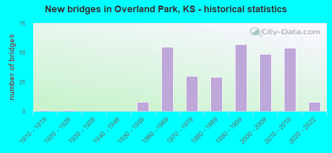
- New bridges - historical statistics
- 11910-1919
- 11920-1929
- 81950-1959
- 551960-1969
- 301970-1979
- 291980-1989
- 571990-1999
- 492000-2009
- 542010-2019
- 82020-2022
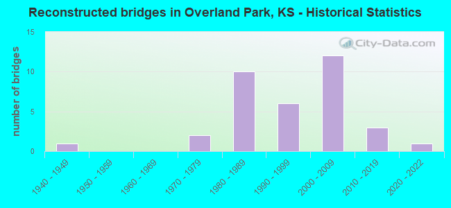
- Reconstructed bridges - Historical Statistics
- 11940-1949
- 01950-1959
- 01960-1969
- 21970-1979
- 101980-1989
- 61990-1999
- 122000-2009
- 32010-2019
- 12020-2022
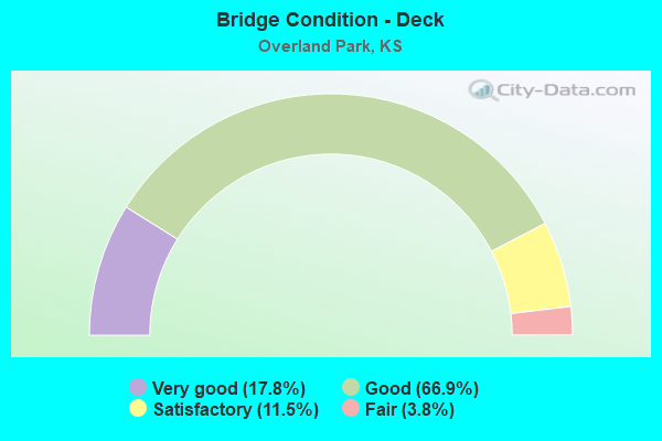
- Bridge Condition - Deck
- 17.8%Very good
- 66.9%Good
- 11.5%Satisfactory
- 3.8%Fair
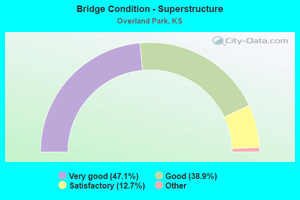
- Bridge Condition - Superstructure
- 47.1%Very good
- 38.9%Good
- 12.7%Satisfactory
- 1.3%Fair
- 0.6%Poor
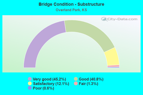
- Bridge Condition - Substructure
- 45.2%Very good
- 40.8%Good
- 12.1%Satisfactory
- 1.3%Fair
- 0.6%Poor
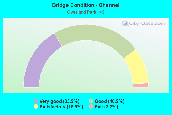
- Bridge Condition - Channel
- 33.2%Very good
- 46.2%Good
- 18.5%Satisfactory
- 2.2%Fair

- Bridge Condition - Culverts
- 19.4%Very good
- 63.4%Good
- 14.0%Satisfactory
- 2.2%Fair
- 1.1%Poor
Find on map >> Show street view
Structure Number: 999906900463691, Location: 3.00 MI S 135TH STREET (Lat: 38.839722, Lng: -94.676389), Route carried "on" structure: City street 2715, Year Built: 2012, Year Reconstructed: 2015, Status: Open, Structure Length: 5.99m (19.65ft), Average Daily Traffic: 4,093 (year 2020), Truck Traffic: 5%, Average Future Daily Traffic: 4,994 (year 2041), Design Load: HL 93, Features Intersected: US-69, Facility Carried by Structure: EB 159TH ST
Minimum Vertical Clearance: 30.47m (99.97ft), Kilometerpoint: 5.732, Lanes on structure: 4, Lanes under structure: 4, Owner: State Highway Agency, Approaching Roadway Width: 8.8m (28.9ft), Material/Design: Prestressed concrete continuous, Design/Construction: Stringer/Multi-beam, Number Of Spans In Main Unit: 2, Length of Maximum Span: 29.3m (96.1ft), Curb or Sidewalk Widths: Left: 0.0m, Right: 1.8m (5.9ft), Curb-To-Curb Width: 19.4m (63.6ft), Out-to-Out Width: 22.7m (74.5ft)
Condition: Deck: Good, Superstructure: Very good, Substructure: Very good, Operating Rating: 57.7 metric tons, Method Used To Determine Operating Rating: Load and Resistance Factor Rating (LRFR) rating reported by rating factor(RF) method using HL-93 loadings, Inventory Rating: 44.4 metric tons, Method Used To Determine Inventory Rating: Load and Resistance Factor Rating (LRFR) rating reported by rating factor(RF) method using HL-93 loadings, Structural Evaluation: Equal to present desirable criteria, Deck Geometry: Better than present minimum criteria, Underclear: Better than present minimum criteria, Approach Roadway Alignment: Somewhat better than minimum adequacy, Length Of Structure Improvement: 19.65m (64.47ft), Designated Inspection Frequency: Every 24 months, Inspection Date: May 2020, Wearing Surface/Protective System: Wearing Surface: Epoxy Overlay, Deck Protection: Epoxy Coated Reinforcing
Find on map >> Show street view
Structure Number: 999906900463781, Location: RAMP I-435 TO SB US-69 (Lat: 38.920278, Lng: -94.704444), Route carried "on" structure: Ramp State highway 59041, Year Built: 2012, Status: Open, Structure Length: 5.57m (18.27ft), Average Daily Traffic: 7,300 (year 2020), Truck Traffic: 3%, Average Future Daily Traffic: 72,509 (year 2041), Design Load: HL 93, Features Intersected: INDIAN CR & PED PASS, Facility Carried by Structure: RAMP 435
Minimum Vertical Clearance: 30.47m (99.97ft), Kilometerpoint: 0.402, Lanes on structure: 3, Owner: State Highway Agency, Approaching Roadway Width: 17.1m (56.1ft), Skew: 2 degrees, Material/Design: Concrete continuous, Design/Construction: Slab, Number Of Spans In Main Unit: 3, Length of Maximum Span: 21.9m (71.9ft), Curb-To-Curb Width: 17.1m (56.1ft), Out-to-Out Width: 18.0m (59.1ft)
Condition: Deck: Good, Superstructure: Good, Substructure: Very good, Channel: Very good, Operating Rating: 66.4 metric tons, Method Used To Determine Operating Rating: Load and Resistance Factor Rating (LRFR) rating reported by rating factor(RF) method using HL-93 loadings, Inventory Rating: 51.2 metric tons, Method Used To Determine Inventory Rating: Load and Resistance Factor Rating (LRFR) rating reported by rating factor(RF) method using HL-93 loadings, Structural Evaluation: Better than present minimum criteria, Deck Geometry: Superior to present desirable criteria, Waterway Adequacy: Equal to present desirable criteria, Approach Roadway Alignment: Better than present minimum criteria, Length Of Structure Improvement: 18.28m (59.97ft), Designated Inspection Frequency: Every 24 months, Inspection Date: May 2020, Wearing Surface/Protective System: Wearing Surface: Epoxy Overlay, Deck Protection: Epoxy Coated Reinforcing
Find on map >> Show street view
Structure Number: 999906900463791, Location: RAMP SB US-69 TO 119TH ST (Lat: 38.920000, Lng: -94.704167), Route carried "on" structure: Ramp State highway 41, Year Built: 2012, Status: Open, Structure Length: 20.23m (66.37ft), Average Daily Traffic: 14,025 (year 2020), Truck Traffic: 3%, Average Future Daily Traffic: 72,509 (year 2041), Design Load: HL 93, Features Intersected: RP435 & INDIAN CR & PASS, Facility Carried by Structure: RAMP SB US-69
Minimum Vertical Clearance: 30.47m (99.97ft), Kilometerpoint: 0.623, Lanes on structure: 2, Lanes under structure: 2, Base Highway Network: Yes (Inventory Route: 4640041, Subroute: 3), Owner: State Highway Agency, Approaching Roadway Width: 11.6m (38.1ft), Skew: 1 degrees, Material/Design: Steel continuous, Design/Construction: Stringer/Multi-beam, Number Of Spans In Main Unit: 4, Number Of Approach Spans: 3, Length of Maximum Span: 37.0m (121.4ft), Curb-To-Curb Width: 11.6m (38.1ft), Out-to-Out Width: 12.5m (41.0ft)
Condition: Deck: Good, Superstructure: Very good, Substructure: Very good, Channel: Very good, Operating Rating: 47.6 metric tons, Method Used To Determine Operating Rating: Load and Resistance Factor Rating (LRFR) rating reported by rating factor(RF) method using HL-93 loadings, Inventory Rating: 36.9 metric tons, Method Used To Determine Inventory Rating: Load and Resistance Factor Rating (LRFR) rating reported by rating factor(RF) method using HL-93 loadings, Structural Evaluation: Equal to present desirable criteria, Deck Geometry: Superior to present desirable criteria, Underclear: High priority of corrective action, Waterway Adequacy: Equal to present desirable criteria, Approach Roadway Alignment: Better than present minimum criteria, Length Of Structure Improvement: 66.38m (217.78ft), Designated Inspection Frequency: Every 24 months, Inspection Date: May 2020, Wearing Surface/Protective System: Wearing Surface: Epoxy Overlay, Deck Protection: Epoxy Coated Reinforcing
Find on map >> Show street view
Structure Number: 999906900463831, Location: 0.54 MI S OF I-435 (Lat: 38.927222, Lng: -94.706111), Route carried "on" structure: Ramp State highway 59041, Year Built: 2012, Status: Open, Structure Length: 15.39m (50.49ft), Average Daily Traffic: 3,290 (year 2020), Truck Traffic: 5%, Average Future Daily Traffic: 68,986 (year 2041), Design Load: HL 93, Features Intersected: COLLEGE BLVD, Facility Carried by Structure: RAMP I-435E To 69S
Minimum Vertical Clearance: 30.47m (99.97ft), Kilometerpoint: 0.377, Lanes on structure: 2, Lanes under structure: 7, Owner: State Highway Agency, Approaching Roadway Width: 11.6m (38.1ft), Material/Design: Steel continuous, Design/Construction: Stringer/Multi-beam, Number Of Spans In Main Unit: 4, Length of Maximum Span: 42.1m (138.1ft), Curb-To-Curb Width: 11.6m (38.1ft), Out-to-Out Width: 12.5m (41.0ft)
Condition: Deck: Good, Superstructure: Very good, Substructure: Very good, Operating Rating: 48.6 metric tons, Method Used To Determine Operating Rating: Load and Resistance Factor Rating (LRFR) rating reported by rating factor(RF) method using HL-93 loadings, Inventory Rating: 37.6 metric tons, Method Used To Determine Inventory Rating: Load and Resistance Factor Rating (LRFR) rating reported by rating factor(RF) method using HL-93 loadings, Structural Evaluation: Equal to present desirable criteria, Deck Geometry: Superior to present desirable criteria, Underclear: High priority of corrective action, Approach Roadway Alignment: Better than present minimum criteria, Length Of Structure Improvement: 50.50m (165.68ft), Designated Inspection Frequency: Every 24 months, Inspection Date: May 2020, Wearing Surface/Protective System: Wearing Surface: Epoxy Overlay, Deck Protection: Epoxy Coated Reinforcing
Find on map >> Show street view
Structure Number: 999906900463881, Location: RAMP I-435 E TO SB US-69 (Lat: 38.929444, Lng: -94.706389), Route carried "on" structure: Ramp State highway 59041, Year Built: 2012, Status: Open, Structure Length: 6.26m (20.54ft), Average Daily Traffic: 3,290 (year 2020), Truck Traffic: 5%, Average Future Daily Traffic: 68,986 (year 2041), Design Load: HL 93, Features Intersected: N BRANCH INDIAN CREEK, Facility Carried by Structure: RAMP 435
Minimum Vertical Clearance: 30.47m (99.97ft), Kilometerpoint: 0.098, Lanes on structure: 2, Owner: State Highway Agency, Approaching Roadway Width: 11.6m (38.1ft), Skew: 1 degrees, Material/Design: Prestressed concrete continuous, Design/Construction: Stringer/Multi-beam, Number Of Spans In Main Unit: 3, Length of Maximum Span: 22.9m (75.1ft), Curb-To-Curb Width: 11.6m (38.1ft), Out-to-Out Width: 12.5m (41.0ft)
Condition: Deck: Very good, Superstructure: Very good, Substructure: Very good, Channel: Very good, Operating Rating: 64.2 metric tons, Method Used To Determine Operating Rating: Load and Resistance Factor Rating (LRFR) rating reported by rating factor(RF) method using HL-93 loadings, Inventory Rating: 35.3 metric tons, Method Used To Determine Inventory Rating: Load and Resistance Factor Rating (LRFR) rating reported by rating factor(RF) method using HL-93 loadings, Structural Evaluation: Equal to present desirable criteria, Deck Geometry: Superior to present desirable criteria, Waterway Adequacy: Equal to present desirable criteria, Approach Roadway Alignment: Better than present minimum criteria, Length Of Structure Improvement: 20.55m (67.42ft), Designated Inspection Frequency: Every 24 months, Inspection Date: May 2020, Wearing Surface/Protective System: Wearing Surface: Epoxy Overlay, Deck Protection: Epoxy Coated Reinforcing
Find on map >> Show street view
Structure Number: 999906900463891, Location: RAMP I-435/COLLEGE (Lat: 38.929444, Lng: -94.705833), Route carried "on" structure: Ramp State highway 42, Year Built: 2012, Status: Open, Structure Length: 6.09m (19.98ft), Average Daily Traffic: 11,025 (year 2020), Truck Traffic: 5%, Average Future Daily Traffic: 68,986 (year 2041), Design Load: HL 93, Features Intersected: N BRANCH INDIAN CREEK, Facility Carried by Structure: RAMP I-435/COLLEGE
Minimum Vertical Clearance: 30.47m (99.97ft), Kilometerpoint: 0.122, Lanes on structure: 4, Owner: State Highway Agency, Approaching Roadway Width: 20.8m (68.2ft), Skew: 2 degrees, Material/Design: Steel continuous, Design/Construction: Stringer/Multi-beam, Number Of Spans In Main Unit: 3, Length of Maximum Span: 22.9m (75.1ft), Curb-To-Curb Width: 20.8m (68.2ft), Out-to-Out Width: 21.7m (71.2ft)
Condition: Deck: Good, Superstructure: Very good, Substructure: Very good, Channel: Very good, Operating Rating: 50.5 metric tons, Method Used To Determine Operating Rating: Load and Resistance Factor Rating (LRFR) rating reported by rating factor(RF) method using HL-93 loadings, Inventory Rating: 38.2 metric tons, Method Used To Determine Inventory Rating: Load and Resistance Factor Rating (LRFR) rating reported by rating factor(RF) method using HL-93 loadings, Structural Evaluation: Equal to present desirable criteria, Deck Geometry: Superior to present desirable criteria, Waterway Adequacy: Equal to present desirable criteria, Approach Roadway Alignment: Better than present minimum criteria, Length Of Structure Improvement: 19.97m (65.52ft), Designated Inspection Frequency: Every 24 months, Inspection Date: May 2020, Wearing Surface/Protective System: Wearing Surface: Epoxy Overlay, Deck Protection: Epoxy Coated Reinforcing
Find on map >> Show street view
Structure Number: 999906900463941, Location: RAMP WB I-435 TO SB US-69 (Lat: 38.931944, Lng: -94.706111), Route carried "on" structure: Ramp State highway 59041, Year Built: 2012, Status: Open, Structure Length: 9.51m (31.20ft), Average Daily Traffic: 8,040 (year 2020), Truck Traffic: 5%, Average Future Daily Traffic: 68,986 (year 2041), Design Load: HL 93, Features Intersected: RAMP 435/COLLEGE, Facility Carried by Structure: RAMP 435
Minimum Vertical Clearance: 30.47m (99.97ft), Kilometerpoint: 0.216, Lanes on structure: 1, Lanes under structure: 1, Owner: State Highway Agency, Approaching Roadway Width: 7.9m (25.9ft), Skew: 3 degrees, Material/Design: Steel continuous, Design/Construction: Stringer/Multi-beam, Number Of Spans In Main Unit: 3, Length of Maximum Span: 41.2m (135.2ft), Curb-To-Curb Width: 7.9m (25.9ft), Out-to-Out Width: 8.8m (28.9ft)
Condition: Deck: Good, Superstructure: Very good, Substructure: Very good, Operating Rating: 50.2 metric tons, Method Used To Determine Operating Rating: Load and Resistance Factor Rating (LRFR) rating reported by rating factor(RF) method using HL-93 loadings, Inventory Rating: 38.9 metric tons, Method Used To Determine Inventory Rating: Load and Resistance Factor Rating (LRFR) rating reported by rating factor(RF) method using HL-93 loadings, Structural Evaluation: Equal to present desirable criteria, Deck Geometry: Equal to present desirable criteria, Underclear: Equal to present minimum criteria, Approach Roadway Alignment: Better than present minimum criteria, Length Of Structure Improvement: 31.19m (102.33ft), Designated Inspection Frequency: Every 24 months, Inspection Date: May 2020, Wearing Surface/Protective System: Wearing Surface: Epoxy Overlay, Deck Protection: Epoxy Coated Reinforcing
Find on map >> Show street view
Structure Number: 999906900463961, Location: RAMP WB I-435 TO SB US-69 (Lat: 38.935000, Lng: -94.705556), Route carried "on" structure: Ramp State highway 59041, Year Built: 2012, Status: Open, Structure Length: 9.95m (32.64ft), Average Daily Traffic: 9,955 (year 2020), Truck Traffic: 5%, Average Future Daily Traffic: 101,787 (year 2041), Design Load: HL 93, Features Intersected: 2 435 RAMPS & E & W 435, Facility Carried by Structure: RAMP 435 W COLLEGE
Minimum Vertical Clearance: 30.47m (99.97ft), Kilometerpoint: 0.090, Lanes on structure: 2, Lanes under structure: 10, Owner: State Highway Agency, Approaching Roadway Width: 11.6m (38.1ft), Skew: 1 degrees, Material/Design: Prestressed concrete continuous, Design/Construction: Stringer/Multi-beam, Number Of Spans In Main Unit: 4, Length of Maximum Span: 27.4m (89.9ft), Curb-To-Curb Width: 11.6m (38.1ft), Out-to-Out Width: 12.5m (41.0ft)
Condition: Deck: Very good, Superstructure: Very good, Substructure: Very good, Operating Rating: 61.2 metric tons, Method Used To Determine Operating Rating: Load and Resistance Factor Rating (LRFR) rating reported by rating factor(RF) method using HL-93 loadings, Inventory Rating: 43.4 metric tons, Method Used To Determine Inventory Rating: Load and Resistance Factor Rating (LRFR) rating reported by rating factor(RF) method using HL-93 loadings, Structural Evaluation: Equal to present desirable criteria, Deck Geometry: Superior to present desirable criteria, Underclear: High priority of corrective action, Approach Roadway Alignment: Better than present minimum criteria, Length Of Structure Improvement: 32.65m (107.12ft), Designated Inspection Frequency: Every 24 months, Inspection Date: May 2020, Wearing Surface/Protective System: Wearing Surface: Epoxy Overlay, Deck Protection: Epoxy Coated Reinforcing
Find on map >> Show street view
Structure Number: 999906900464241, Location: 5.12 MI N MIAMI COLN, NB (Lat: 38.812222, Lng: -94.675278), Route carried "on" structure: US 69, Year Built: 2017, Status: Open, Structure Length: 7.85m (25.75ft), Average Daily Traffic: 16,819 (year 2020), Truck Traffic: 7%, Average Future Daily Traffic: 27,560 (year 2041), Design Load: HL 93, Features Intersected: BLUE RIVER
Minimum Vertical Clearance: 30.47m (99.97ft), Kilometerpoint: 8.238, Lanes on structure: 2, Base Highway Network: Yes, Owner: State Highway Agency, Approaching Roadway Width: 12.2m (40.0ft), Material/Design: Prestressed concrete continuous, Design/Construction: Stringer/Multi-beam, Number Of Spans In Main Unit: 3, Length of Maximum Span: 30.5m (100.1ft), Curb-To-Curb Width: 12.2m (40.0ft), Out-to-Out Width: 13.0m (42.7ft)
Condition: Deck: Very good, Superstructure: Very good, Substructure: Very good, Channel: Very good, Operating Rating: 58.6 metric tons, Method Used To Determine Operating Rating: Load and Resistance Factor Rating (LRFR) rating reported by rating factor(RF) method using HL-93 loadings, Inventory Rating: 34.7 metric tons, Method Used To Determine Inventory Rating: Load and Resistance Factor Rating (LRFR) rating reported by rating factor(RF) method using HL-93 loadings, Structural Evaluation: Equal to present desirable criteria, Deck Geometry: Better than present minimum criteria, Waterway Adequacy: Equal to present desirable criteria, Approach Roadway Alignment: Equal to present desirable criteria, Length Of Structure Improvement: 25.75m (84.48ft), Designated Inspection Frequency: Every 24 months, Inspection Date: May 2020, Wearing Surface/Protective System: Wearing Surface: Epoxy Overlay, Deck Protection: Epoxy Coated Reinforcing
Find on map >> Show street view
Structure Number: 999906900610151, Location: JOHNSON MIAMI CO LN (Lat: 38.738056, Lng: -94.676111), Route carried "on" structure: ServiceCounty highway 32, Year Built: 1967, Status: Open, Structure Length: 7.35m (24.11ft), Average Daily Traffic: 76 (year 2020), Average Future Daily Traffic: 16,058 (year 2041), Design Load: H 20, Features Intersected: US 69 HWY, Facility Carried by Structure: CO. LN RD 215TH ST
Minimum Vertical Clearance: 30.47m (99.97ft), Kilometerpoint: 0.760, Lanes on structure: 2, Lanes under structure: 4, Owner: State Highway Agency, Approaching Roadway Width: 8.5m (27.9ft), Material/Design: Concrete continuous, Design/Construction: Box Beam or Girders - Multiple, Number Of Spans In Main Unit: 4, Length of Maximum Span: 20.7m (67.9ft), Curb-To-Curb Width: 8.5m (27.9ft), Out-to-Out Width: 9.1m (29.9ft)
Condition: Deck: Good, Superstructure: Good, Substructure: Very good, Operating Rating: 82.6 metric tons, Method Used To Determine Operating Rating: Load Factor (LF), Inventory Rating: 49.4 metric tons, Method Used To Determine Inventory Rating: Load Factor (LF), Structural Evaluation: Better than present minimum criteria, Deck Geometry: Better than present minimum criteria, Underclear: Equal to present minimum criteria, Approach Roadway Alignment: Somewhat better than minimum adequacy, Length Of Structure Improvement: 24.10m (79.07ft), Designated Inspection Frequency: Every 24 months, Inspection Date: March 2020, Deck Structure Type: Concrete Cast-file-Place, Wearing Surface/Protective System: Wearing Surface: Monolithic Concrete
Find on map >> Show street view
Structure Number: 999943500460471, Location: 0.63 MI E US69ALT, WB (Lat: 38.934722, Lng: -94.693056), Route carried "on" structure: Interstate 435, Year Built: 1965, Year Reconstructed: 1987, Status: Open, Structure Length: 7.39m (24.25ft), Average Daily Traffic: 70,607 (year 2020), Truck Traffic: 5%, Average Future Daily Traffic: 91,419 (year 2041), Design Load: HS 20+Mod, Features Intersected: INDIAN CREEK
Minimum Vertical Clearance: 30.47m (99.97ft), Kilometerpoint: 7.541, Lanes on structure: 4, Base Highway Network: Yes, Owner: State Highway Agency, Approaching Roadway Width: 17.1m (56.1ft), Material/Design: Concrete continuous, Design/Construction: Tee Beam, Number Of Spans In Main Unit: 4, Length of Maximum Span: 21.3m (69.9ft), Curb-To-Curb Width: 20.6m (67.6ft), Out-to-Out Width: 21.4m (70.2ft)
Condition: Deck: Good, Superstructure: Good, Substructure: Good, Channel: Very good, Operating Rating: 51.3 metric tons, Method Used To Determine Operating Rating: Load Factor (LF), Inventory Rating: 32.3 metric tons, Method Used To Determine Inventory Rating: Load Factor (LF), Structural Evaluation: Better than present minimum criteria, Deck Geometry: Equal to present minimum criteria, Waterway Adequacy: Equal to present desirable criteria, Approach Roadway Alignment: Equal to present desirable criteria, Length Of Structure Improvement: 24.25m (79.56ft), Designated Inspection Frequency: Every 24 months, Inspection Date: May 2020, Deck Structure Type: Concrete Cast-file-Place, Wearing Surface/Protective System: Wearing Surface: Epoxy Overlay
Find on map >> Show street view
Structure Number: 999943500460481, Location: 0.62 MI E OF US69 (Lat: 38.934444, Lng: -94.693333), Route carried "on" structure: Interstate 435, Year Built: 1965, Year Reconstructed: 1987, Status: Open, Structure Length: 7.39m (24.25ft), Average Daily Traffic: 70,607 (year 2020), Truck Traffic: 5%, Average Future Daily Traffic: 91,419 (year 2041), Design Load: HS 20+Mod, Features Intersected: INDIAN CREEK
Minimum Vertical Clearance: 30.47m (99.97ft), Kilometerpoint: 7.545, Lanes on structure: 4, Base Highway Network: Yes, Owner: State Highway Agency, Approaching Roadway Width: 17.1m (56.1ft), Material/Design: Concrete continuous, Design/Construction: Tee Beam, Number Of Spans In Main Unit: 4, Length of Maximum Span: 21.3m (69.9ft), Curb-To-Curb Width: 20.6m (67.6ft), Out-to-Out Width: 21.4m (70.2ft)
Condition: Deck: Good, Superstructure: Good, Substructure: Good, Channel: Very good, Operating Rating: 47.8 metric tons, Method Used To Determine Operating Rating: Load Factor (LF), Inventory Rating: 30.1 metric tons, Method Used To Determine Inventory Rating: Load Factor (LF), Structural Evaluation: Better than present minimum criteria, Deck Geometry: Equal to present minimum criteria, Waterway Adequacy: Better than present minimum criteria, Approach Roadway Alignment: Equal to present desirable criteria, Length Of Structure Improvement: 24.25m (79.56ft), Designated Inspection Frequency: Every 24 months, Inspection Date: May 2020, Deck Structure Type: Concrete Cast-file-Place, Wearing Surface/Protective System: Wearing Surface: Epoxy Overlay
Find on map >> Show street view
Structure Number: 999943500460501, Location: JCT METCALF/I435 WB (Lat: 38.931944, Lng: -94.667500), Route carried "on" structure: Interstate 435, Year Built: 1965, Year Reconstructed: 1987, Status: Open, Structure Length: 6.70m (21.98ft), Average Daily Traffic: 69,204 (year 2020), Truck Traffic: 5%, Average Future Daily Traffic: 89,602 (year 2041), Design Load: HS 20+Mod, Features Intersected: METCALF
Minimum Vertical Clearance: 30.47m (99.97ft), Kilometerpoint: 5.277, Lanes on structure: 4, Lanes under structure: 6, Base Highway Network: Yes, Owner: State Highway Agency, Approaching Roadway Width: 17.1m (56.1ft), Skew: 1 degrees, Material/Design: Steel continuous, Design/Construction: Stringer/Multi-beam, Number Of Spans In Main Unit: 4, Length of Maximum Span: 18.3m (60.0ft), Curb-To-Curb Width: 20.6m (67.6ft), Out-to-Out Width: 21.4m (70.2ft)
Condition: Deck: Good, Superstructure: Very good, Substructure: Good, Operating Rating: 36.3 metric tons, Method Used To Determine Operating Rating: Load Factor (LF), Inventory Rating: 21.8 metric tons, Method Used To Determine Inventory Rating: Load Factor (LF), Structural Evaluation: Somewhat better than minimum adequacy, Deck Geometry: Equal to present minimum criteria, Underclear: Meets minimum limits, Approach Roadway Alignment: Equal to present desirable criteria, Length Of Structure Improvement: 21.98m (72.11ft), Designated Inspection Frequency: Every 24 months, Inspection Date: May 2020, Deck Structure Type: Concrete Cast-file-Place, Wearing Surface/Protective System: Wearing Surface: Low Slump Concrete
Find on map >> Show street view
Structure Number: 999943500460511, Location: JCT METCALF/I435 SL (Lat: 38.931667, Lng: -94.667500), Route carried "on" structure: Interstate 435, Year Built: 1965, Year Reconstructed: 1987, Status: Open, Structure Length: 6.70m (21.98ft), Average Daily Traffic: 69,204 (year 2020), Truck Traffic: 5%, Average Future Daily Traffic: 89,602 (year 2041), Design Load: HS 20+Mod, Features Intersected: METCALF
Minimum Vertical Clearance: 30.47m (99.97ft), Kilometerpoint: 5.285, Lanes on structure: 4, Lanes under structure: 8, Base Highway Network: Yes, Owner: State Highway Agency, Approaching Roadway Width: 17.1m (56.1ft), Skew: 1 degrees, Material/Design: Steel continuous, Design/Construction: Stringer/Multi-beam, Number Of Spans In Main Unit: 4, Length of Maximum Span: 18.3m (60.0ft), Curb-To-Curb Width: 20.6m (67.6ft), Out-to-Out Width: 21.4m (70.2ft)
Condition: Deck: Good, Superstructure: Very good, Substructure: Satisfactory, Operating Rating: 58.1 metric tons, Method Used To Determine Operating Rating: Load Factor (LF), Inventory Rating: 34.7 metric tons, Method Used To Determine Inventory Rating: Load Factor (LF), Structural Evaluation: Equal to present minimum criteria, Deck Geometry: Equal to present minimum criteria, Underclear: Meets minimum limits, Approach Roadway Alignment: Equal to present desirable criteria, Length Of Structure Improvement: 21.98m (72.11ft), Designated Inspection Frequency: Every 24 months, Inspection Date: May 2020, Deck Structure Type: Concrete Cast-file-Place, Wearing Surface/Protective System: Wearing Surface: Low Slump Concrete
Find on map >> Show street view
Structure Number: 999943500462491, Location: 1.17 MI W US69 (Lat: 38.935000, Lng: -94.726389), Route carried "on" structure: Interstate 435, Year Built: 1965, Year Reconstructed: 2014, Status: Open, Structure Length: 0.97m (3.18ft), Average Daily Traffic: 59,384 (year 2020), Truck Traffic: 5%, Average Future Daily Traffic: 88,242 (year 2041), Design Load: HS 20+Mod, Features Intersected: INDIAN CREEK TRIBUTARY
Minimum Vertical Clearance: 30.47m (99.97ft), Kilometerpoint: 10.411, Lanes on structure: 8, Base Highway Network: Yes, Owner: State Highway Agency, Approaching Roadway Width: 35.4m (116.1ft), Skew: 30 degrees, Material/Design: Concrete, Design/Construction: Culvert, Number Of Spans In Main Unit: 2, Length of Maximum Span: 5.5m (18.0ft), Curb-To-Curb Width: 42.7m (140.1ft), Out-to-Out Width: 113.7m (373.0ft)
Condition: Channel: Good, Culverts: Good, Operating Rating: 89.8 metric tons, Method Used To Determine Operating Rating: Load Factor (LF), Inventory Rating: 89.8 metric tons, Method Used To Determine Inventory Rating: Load Factor (LF), Structural Evaluation: Better than present minimum criteria, Deck Geometry: Superior to present desirable criteria, Waterway Adequacy: Equal to present minimum criteria, Approach Roadway Alignment: Equal to present desirable criteria, Length Of Structure Improvement: 3.19m (10.47ft), Designated Inspection Frequency: Every 24 months, Inspection Date: May 2020, Deck Structure Type: Concrete Cast-file-Place, Wearing Surface/Protective System: Wearing Surface: Monolithic Concrete
Find on map >> Show street view
Structure Number: 999943500463021, Location: 0.52 MI E US-69 (Lat: 38.930556, Lng: -94.658056), Route carried "on" structure: City street 2975, Year Built: 1996, Status: Open, Structure Length: 8.98m (29.46ft), Average Daily Traffic: 5,044 (year 2020), Truck Traffic: 5%, Average Future Daily Traffic: 5,146 (year 2041), Design Load: HS 20, Features Intersected: I-435 HWY, Facility Carried by Structure: LAMAR AVE
Minimum Vertical Clearance: 30.47m (99.97ft), Kilometerpoint: 1.001, Lanes on structure: 2, Lanes under structure: 10, Owner: State Highway Agency, Approaching Roadway Width: 9.8m (32.2ft), Material/Design: Steel continuous, Design/Construction: Stringer/Multi-beam, Number Of Spans In Main Unit: 4, Length of Maximum Span: 25.9m (85.0ft), Curb or Sidewalk Widths: Left: 1.8m (5.9ft), Right: 1.8m (5.9ft), Curb-To-Curb Width: 10.7m (35.1ft), Out-to-Out Width: 15.1m (49.5ft)
Condition: Deck: Good, Superstructure: Good, Substructure: Satisfactory, Operating Rating: 64.4 metric tons, Method Used To Determine Operating Rating: Load Factor (LF), Inventory Rating: 38.1 metric tons, Method Used To Determine Inventory Rating: Load Factor (LF), Structural Evaluation: Equal to present minimum criteria, Deck Geometry: Meets minimum limits, Underclear: Meets minimum limits, Approach Roadway Alignment: Meets minimum limits, Length Of Structure Improvement: 29.45m (96.62ft), Designated Inspection Frequency: Every 24 months, Inspection Date: May 2020, Wearing Surface/Protective System: Wearing Surface: Low Slump Concrete, Deck Protection: Epoxy Coated Reinforcing
Find on map >> Show street view
Structure Number: 999943500463031, Location: 1.02 MI E OF US-169 (Lat: 38.931389, Lng: -94.648611), Route carried "on" structure: City street 3001, Year Built: 1996, Status: Open, Structure Length: 8.43m (27.66ft), Average Daily Traffic: 8,286 (year 2020), Truck Traffic: 7%, Average Future Daily Traffic: 12,313 (year 2041), Design Load: HS 25 or greater, Features Intersected: I-435 HWY & NB & SB CD'S, Facility Carried by Structure: NALL NB
Minimum Vertical Clearance: 30.47m (99.97ft), Kilometerpoint: 11.790, Lanes on structure: 4, Lanes under structure: 10, Owner: State Highway Agency, Approaching Roadway Width: 11.8m (38.7ft), Skew: 20 degrees, Material/Design: Steel continuous, Design/Construction: Stringer/Multi-beam, Number Of Spans In Main Unit: 4, Length of Maximum Span: 26.5m (86.9ft), Curb or Sidewalk Widths: Left: 0.0m, Right: 1.5m (4.9ft), Curb-To-Curb Width: 11.8m (38.7ft), Out-to-Out Width: 17.3m (56.8ft)
Condition: Deck: Good, Superstructure: Good, Substructure: Good, Operating Rating: 76.2 metric tons, Method Used To Determine Operating Rating: Load Factor (LF), Inventory Rating: 44.5 metric tons, Method Used To Determine Inventory Rating: Load Factor (LF), Structural Evaluation: Better than present minimum criteria, Deck Geometry: High priority of replacement, Underclear: Somewhat better than minimum adequacy, Approach Roadway Alignment: Somewhat better than minimum adequacy, Length Of Structure Improvement: 27.65m (90.72ft), Designated Inspection Frequency: Every 24 months, Inspection Date: May 2020, Wearing Surface/Protective System: Wearing Surface: Low Slump Concrete, Deck Protection: Epoxy Coated Reinforcing
Find on map >> Show street view
Structure Number: 999943500463041, Location: 1.02 MI E OF US-169 (Lat: 38.931667, Lng: -94.648889), Route carried "on" structure: City street 3001, Year Built: 1996, Status: Open, Structure Length: 8.43m (27.66ft), Average Daily Traffic: 8,286 (year 2020), Truck Traffic: 7%, Average Future Daily Traffic: 12,313 (year 2041), Design Load: HS 25 or greater, Features Intersected: I-435 HWY & NB & SB CD'S, Facility Carried by Structure: NALL SB
Minimum Vertical Clearance: 30.47m (99.97ft), Kilometerpoint: 11.788, Lanes on structure: 4, Lanes under structure: 10, Owner: State Highway Agency, Approaching Roadway Width: 11.8m (38.7ft), Skew: 20 degrees, Material/Design: Steel continuous, Design/Construction: Stringer/Multi-beam, Number Of Spans In Main Unit: 4, Length of Maximum Span: 26.5m (86.9ft), Curb or Sidewalk Widths: Left: 1.5m (4.9ft), Right: 0.0m, Curb-To-Curb Width: 11.8m (38.7ft), Out-to-Out Width: 17.3m (56.8ft)
Condition: Deck: Good, Superstructure: Good, Substructure: Good, Operating Rating: 78.0 metric tons, Method Used To Determine Operating Rating: Load Factor (LF), Inventory Rating: 46.3 metric tons, Method Used To Determine Inventory Rating: Load Factor (LF), Structural Evaluation: Better than present minimum criteria, Deck Geometry: High priority of replacement, Underclear: Somewhat better than minimum adequacy, Approach Roadway Alignment: Somewhat better than minimum adequacy, Length Of Structure Improvement: 27.66m (90.75ft), Designated Inspection Frequency: Every 24 months, Inspection Date: May 2020, Wearing Surface/Protective System: Wearing Surface: Low Slump Concrete, Deck Protection: Epoxy Coated Reinforcing
Find on map >> Show street view
Structure Number: 999943500463051, Location: 1.40 MI W OF STATE LINE (Lat: 38.932778, Lng: -94.633611), Route carried "on" structure: Interstate 435, Year Built: 1996, Status: Open, Structure Length: 7.51m (24.64ft), Average Daily Traffic: 67,801 (year 2020), Truck Traffic: 5%, Average Future Daily Traffic: 87,786 (year 2041), Design Load: HS 25 or greater, Features Intersected: INDIAN CREEK & PED PASS
Minimum Vertical Clearance: 30.47m (99.97ft), Kilometerpoint: 2.324, Lanes on structure: 6, Base Highway Network: Yes, Owner: State Highway Agency, Approaching Roadway Width: 28.5m (93.5ft), Material/Design: Concrete, Design/Construction: Slab, Number Of Spans In Main Unit: 5, Length of Maximum Span: 16.5m (54.1ft), Curb-To-Curb Width: 28.5m (93.5ft), Out-to-Out Width: 29.3m (96.1ft)
Condition: Deck: Good, Superstructure: Good, Substructure: Good, Channel: Very good, Operating Rating: 78.9 metric tons, Method Used To Determine Operating Rating: Load Factor (LF), Inventory Rating: 47.2 metric tons, Method Used To Determine Inventory Rating: Load Factor (LF), Structural Evaluation: Better than present minimum criteria, Deck Geometry: Better than present minimum criteria, Waterway Adequacy: Better than present minimum criteria, Approach Roadway Alignment: Equal to present desirable criteria, Length Of Structure Improvement: 24.65m (80.87ft), Designated Inspection Frequency: Every 24 months, Inspection Date: May 2020, Wearing Surface/Protective System: Wearing Surface: Monolithic Concrete, Deck Protection: Epoxy Coated Reinforcing
Find on map >> Show street view
Structure Number: 999943500463061, Location: 1.41 MI W OF STATE LINE (Lat: 38.933056, Lng: -94.633611), Route carried "on" structure: Interstate 435, Year Built: 1996, Status: Open, Structure Length: 7.51m (24.64ft), Average Daily Traffic: 67,801 (year 2020), Truck Traffic: 5%, Average Future Daily Traffic: 87,786 (year 2041), Design Load: HS 25 or greater, Features Intersected: INDIAN CREEK & PED PASS
Minimum Vertical Clearance: 30.47m (99.97ft), Kilometerpoint: 2.326, Lanes on structure: 6, Base Highway Network: Yes, Owner: State Highway Agency, Approaching Roadway Width: 28.1m (92.2ft), Material/Design: Concrete, Design/Construction: Slab, Number Of Spans In Main Unit: 5, Length of Maximum Span: 16.5m (54.1ft), Curb-To-Curb Width: 28.1m (92.2ft), Out-to-Out Width: 28.9m (94.8ft)
Condition: Deck: Good, Superstructure: Good, Substructure: Good, Channel: Good, Operating Rating: 78.9 metric tons, Method Used To Determine Operating Rating: Load Factor (LF), Inventory Rating: 47.2 metric tons, Method Used To Determine Inventory Rating: Load Factor (LF), Structural Evaluation: Better than present minimum criteria, Deck Geometry: Equal to present minimum criteria, Waterway Adequacy: Better than present minimum criteria, Approach Roadway Alignment: Equal to present desirable criteria, Length Of Structure Improvement: 24.65m (80.87ft), Designated Inspection Frequency: Every 24 months, Inspection Date: May 2020, Wearing Surface/Protective System: Wearing Surface: Monolithic Concrete, Deck Protection: Epoxy Coated Reinforcing
Find on map >> Show street view
Structure Number: 999943500463071, Location: 1.24 MI W OF STATE LINE (Lat: 38.932778, Lng: -94.630000), Route carried "on" structure: Interstate 435, Year Built: 1996, Status: Open, Structure Length: 4.95m (16.24ft), Average Daily Traffic: 67,801 (year 2020), Truck Traffic: 5%, Average Future Daily Traffic: 87,786 (year 2041), Design Load: HS 25 or greater, Features Intersected: MISSION RD
Minimum Vertical Clearance: 30.47m (99.97ft), Kilometerpoint: 2.007, Lanes on structure: 6, Lanes under structure: 2, Base Highway Network: Yes, Owner: State Highway Agency, Approaching Roadway Width: 27.5m (90.2ft), Material/Design: Concrete continuous, Design/Construction: Slab, Number Of Spans In Main Unit: 3, Length of Maximum Span: 19.5m (64.0ft), Curb-To-Curb Width: 27.4m (89.9ft), Out-to-Out Width: 28.3m (92.8ft)
Condition: Deck: Good, Superstructure: Good, Substructure: Very good, Operating Rating: 69.9 metric tons, Method Used To Determine Operating Rating: Load Factor (LF), Inventory Rating: 41.7 metric tons, Method Used To Determine Inventory Rating: Load Factor (LF), Structural Evaluation: Better than present minimum criteria, Deck Geometry: Equal to present minimum criteria, Underclear: Somewhat better than minimum adequacy, Approach Roadway Alignment: Equal to present desirable criteria, Length Of Structure Improvement: 16.25m (53.31ft), Designated Inspection Frequency: Every 24 months, Inspection Date: May 2020, Wearing Surface/Protective System: Wearing Surface: Monolithic Concrete, Deck Protection: Epoxy Coated Reinforcing
Find on map >> Show street view
Structure Number: 999943500463081, Location: 1.25 MI W OF STATE LINE (Lat: 38.933056, Lng: -94.630000), Route carried "on" structure: Interstate 435, Year Built: 1996, Status: Open, Structure Length: 4.95m (16.24ft), Average Daily Traffic: 67,801 (year 2020), Truck Traffic: 5%, Average Future Daily Traffic: 87,786 (year 2041), Design Load: HS 25 or greater, Features Intersected: MISSION RD
Minimum Vertical Clearance: 30.47m (99.97ft), Kilometerpoint: 2.007, Lanes on structure: 5, Lanes under structure: 2, Base Highway Network: Yes, Owner: State Highway Agency, Approaching Roadway Width: 24.4m (80.1ft), Material/Design: Concrete continuous, Design/Construction: Slab, Number Of Spans In Main Unit: 3, Length of Maximum Span: 19.5m (64.0ft), Curb-To-Curb Width: 24.4m (80.1ft), Out-to-Out Width: 25.2m (82.7ft)
Condition: Deck: Good, Superstructure: Good, Substructure: Very good, Operating Rating: 69.9 metric tons, Method Used To Determine Operating Rating: Load Factor (LF), Inventory Rating: 41.7 metric tons, Method Used To Determine Inventory Rating: Load Factor (LF), Structural Evaluation: Better than present minimum criteria, Deck Geometry: Equal to present minimum criteria, Underclear: Somewhat better than minimum adequacy, Approach Roadway Alignment: Equal to present desirable criteria, Length Of Structure Improvement: 16.25m (53.31ft), Designated Inspection Frequency: Every 24 months, Inspection Date: May 2020, Wearing Surface/Protective System: Wearing Surface: Monolithic Concrete, Deck Protection: Epoxy Coated Reinforcing
Find on map >> Show street view
Structure Number: 999943500463341, Location: I-435 & ANTIOCH RD JCT (Lat: 38.934167, Lng: -94.686111), Route carried "on" structure: City street 2901, Year Built: 2008, Status: Open, Structure Length: 5.88m (19.29ft), Average Daily Traffic: 9,046 (year 2020), Truck Traffic: 7%, Average Future Daily Traffic: 18,457 (year 2041), Design Load: HS 20, Features Intersected: I-435 HWY, Facility Carried by Structure: ANTIOCH ROAD, NB
Minimum Vertical Clearance: 30.47m (99.97ft), Kilometerpoint: 12.102, Lanes on structure: 4, Lanes under structure: 11, Owner: State Highway Agency, Approaching Roadway Width: 15.6m (51.2ft), Skew: 20 degrees, Material/Design: Steel continuous, Design/Construction: Stringer/Multi-beam, Number Of Spans In Main Unit: 2, Length of Maximum Span: 31.0m (101.7ft), Curb or Sidewalk Widths: Left: 0.0m, Right: 1.8m (5.9ft), Curb-To-Curb Width: 15.6m (51.2ft), Out-to-Out Width: 18.9m (62.0ft)
Condition: Deck: Good, Superstructure: Good, Substructure: Good, Operating Rating: 37.6 metric tons, Method Used To Determine Operating Rating: Load and Resistance Factor Rating (LRFR) rating reported by rating factor(RF) method using HL-93 loadings, Inventory Rating: 29.2 metric tons, Method Used To Determine Inventory Rating: Load and Resistance Factor Rating (LRFR) rating reported by rating factor(RF) method using HL-93 loadings, Structural Evaluation: Better than present minimum criteria, Deck Geometry: Meets minimum limits, Underclear: High priority of corrective action, Approach Roadway Alignment: Somewhat better than minimum adequacy, Length Of Structure Improvement: 19.29m (63.29ft), Designated Inspection Frequency: Every 24 months, Inspection Date: May 2020, Wearing Surface/Protective System: Wearing Surface: Low Slump Concrete, Deck Protection: Epoxy Coated Reinforcing
Find on map >> Show street view
Structure Number: 999943500463351, Location: I-435 & ANTIOCH RD JCT (Lat: 38.934167, Lng: -94.686389), Route carried "on" structure: City street 2901, Year Built: 2008, Status: Open, Structure Length: 5.88m (19.29ft), Average Daily Traffic: 9,046 (year 2020), Truck Traffic: 7%, Average Future Daily Traffic: 17,565 (year 2041), Design Load: HS 20, Features Intersected: I-435 HWY, Facility Carried by Structure: ANTIOCH ROAD, SB
Minimum Vertical Clearance: 30.47m (99.97ft), Kilometerpoint: 12.102, Lanes on structure: 5, Lanes under structure: 11, Owner: State Highway Agency, Approaching Roadway Width: 19.3m (63.3ft), Material/Design: Steel continuous, Design/Construction: Stringer/Multi-beam, Number Of Spans In Main Unit: 2, Length of Maximum Span: 31.0m (101.7ft), Curb or Sidewalk Widths: Left: 1.8m (5.9ft), Right: 0.0m, Curb-To-Curb Width: 19.3m (63.3ft), Out-to-Out Width: 22.6m (74.1ft)
Condition: Deck: Good, Superstructure: Very good, Substructure: Good, Operating Rating: 62.6 metric tons, Method Used To Determine Operating Rating: Load Factor (LF), Inventory Rating: 37.5 metric tons, Method Used To Determine Inventory Rating: Load Factor (LF), Structural Evaluation: Better than present minimum criteria, Deck Geometry: Meets minimum limits, Underclear: High priority of corrective action, Approach Roadway Alignment: Somewhat better than minimum adequacy, Length Of Structure Improvement: 19.29m (63.29ft), Designated Inspection Frequency: Every 24 months, Inspection Date: May 2020, Wearing Surface/Protective System: Wearing Surface: Low Slump Concrete, Deck Protection: Epoxy Coated Reinforcing
Find on map >> Show street view
Structure Number: 999943500463411, Location: RAMP US-69S TO I-435 EB (Lat: 38.935278, Lng: -94.703889), Route carried "on" structure: Ramp State highway 43063, Year Built: 2009, Status: Open, Structure Length: 52.06m (170.80ft), Average Daily Traffic: 16,920 (year 2020), Truck Traffic: 3%, Average Future Daily Traffic: 112,189 (year 2041), Design Load: HS 20, Features Intersected: I-435 HWY & US-69 HWY, Facility Carried by Structure: RAMP 69S TO 435 E
Minimum Vertical Clearance: 30.47m (99.97ft), Kilometerpoint: 0.315, Lanes on structure: 2, Lanes under structure: 9, Owner: State Highway Agency, Approaching Roadway Width: 11.6m (38.1ft), Material/Design: Steel continuous, Design/Construction: Stringer/Multi-beam, Number Of Spans In Main Unit: 8, Length of Maximum Span: 73.2m (240.2ft), Curb-To-Curb Width: 11.6m (38.1ft), Out-to-Out Width: 12.4m (40.7ft)
Condition: Deck: Good, Superstructure: Very good, Substructure: Good, Operating Rating: 35.0 metric tons, Method Used To Determine Operating Rating: Load and Resistance Factor Rating (LRFR) rating reported by rating factor(RF) method using HL-93 loadings, Inventory Rating: 27.2 metric tons, Method Used To Determine Inventory Rating: Load and Resistance Factor Rating (LRFR) rating reported by rating factor(RF) method using HL-93 loadings, Structural Evaluation: Equal to present minimum criteria, Deck Geometry: Superior to present desirable criteria, Underclear: Equal to present minimum criteria, Approach Roadway Alignment: Meets minimum limits, Length Of Structure Improvement: 170.80m (560.37ft), Designated Inspection Frequency: Every 12 months, Critical Feature Inspection Frequency: Every 24 months, Inspection Date: August 2021, Critical Feature Inspection Date: July 2020, Wearing Surface/Protective System: Wearing Surface: Low Slump Concrete, Deck Protection: Epoxy Coated Reinforcing
Find on map >> Show street view
Structure Number: 999943500463421, Location: RAMP 69N TO 435E (Lat: 38.933889, Lng: -94.703333), Route carried "on" structure: Ramp State highway 59063, Year Built: 2009, Status: Open, Structure Length: 7.48m (24.54ft), Average Daily Traffic: 8,665 (year 2020), Truck Traffic: 5%, Average Future Daily Traffic: 97,754 (year 2041), Design Load: HL 93, Features Intersected: RAMP 435 TO ANTIOCH RD, Facility Carried by Structure: RAMP 69N TO 435E
Minimum Vertical Clearance: 30.47m (99.97ft), Kilometerpoint: 0.443, Lanes on structure: 2, Lanes under structure: 1, Owner: State Highway Agency, Approaching Roadway Width: 9.1m (29.9ft), Material/Design: Prestressed concrete continuous, Design/Construction: Stringer/Multi-beam, Number Of Spans In Main Unit: 3, Length of Maximum Span: 28.0m (91.9ft), Curb-To-Curb Width: 9.1m (29.9ft), Out-to-Out Width: 9.9m (32.5ft)
Condition: Deck: Very good, Superstructure: Very good, Substructure: Very good, Operating Rating: 65.1 metric tons, Method Used To Determine Operating Rating: Load and Resistance Factor Rating (LRFR) rating reported by rating factor(RF) method using HL-93 loadings, Inventory Rating: 34.0 metric tons, Method Used To Determine Inventory Rating: Load and Resistance Factor Rating (LRFR) rating reported by rating factor(RF) method using HL-93 loadings, Structural Evaluation: Equal to present desirable criteria, Deck Geometry: Meets minimum limits, Underclear: Equal to present minimum criteria, Approach Roadway Alignment: Somewhat better than minimum adequacy, Length Of Structure Improvement: 24.54m (80.51ft), Designated Inspection Frequency: Every 24 months, Inspection Date: May 2020, Wearing Surface/Protective System: Wearing Surface: Low Slump Concrete, Deck Protection: Epoxy Coated Reinforcing
Find on map >> Show street view
Structure Number: 999943500463441, Location: RMP 69S-I435E & 69N-ANTCH (Lat: 38.934444, Lng: -94.693056), Route carried "on" structure: Ramp State highway 59063, Year Built: 2008, Status: Open, Structure Length: 7.39m (24.25ft), Average Daily Traffic: 30,000 (year 2020), Truck Traffic: 5%, Average Future Daily Traffic: 97,754 (year 2041), Design Load: HS 20, Features Intersected: INDIAN CREEK, Facility Carried by Structure: RAMP 69S-I435E
Minimum Vertical Clearance: 30.47m (99.97ft), Kilometerpoint: 0.406, Lanes on structure: 2, Owner: State Highway Agency, Approaching Roadway Width: 15.3m (50.2ft), Material/Design: Concrete continuous, Design/Construction: Slab, Number Of Spans In Main Unit: 4, Length of Maximum Span: 21.3m (69.9ft), Curb-To-Curb Width: 15.3m (50.2ft), Out-to-Out Width: 16.1m (52.8ft)
Condition: Deck: Good, Superstructure: Good, Substructure: Good, Channel: Very good, Operating Rating: 90.6 metric tons, Method Used To Determine Operating Rating: Load Factor (LF), Inventory Rating: 58.1 metric tons, Method Used To Determine Inventory Rating: Load Factor (LF), Structural Evaluation: Better than present minimum criteria, Deck Geometry: Superior to present desirable criteria, Waterway Adequacy: Equal to present desirable criteria, Approach Roadway Alignment: Equal to present desirable criteria, Length Of Structure Improvement: 24.25m (79.56ft), Designated Inspection Frequency: Every 24 months, Inspection Date: May 2020, Wearing Surface/Protective System: Wearing Surface: Monolithic Concrete, Deck Protection: Epoxy Coated Reinforcing
Find on map >> Show street view
Structure Number: 999943500463451, Location: RMP ANTCH TO I-435W/U-69N (Lat: 38.935000, Lng: -94.693056), Route carried "on" structure: Ramp State highway 63060, Year Built: 2008, Status: Open, Structure Length: 9.59m (31.46ft), Average Daily Traffic: 26,395 (year 2020), Truck Traffic: 5%, Average Future Daily Traffic: 97,754 (year 2041), Design Load: HL 93, Features Intersected: INDIAN CREEK, Facility Carried by Structure: RMP ANTCH-I435/U69
Minimum Vertical Clearance: 30.47m (99.97ft), Kilometerpoint: 0.610, Lanes on structure: 2, Owner: State Highway Agency, Approaching Roadway Width: 9.8m (32.2ft), Skew: 1 degrees, Material/Design: Steel continuous, Design/Construction: Stringer/Multi-beam, Number Of Spans In Main Unit: 5, Length of Maximum Span: 25.1m (82.3ft), Curb-To-Curb Width: 9.8m (32.2ft), Out-to-Out Width: 13.0m (42.7ft)
Condition: Deck: Good, Superstructure: Very good, Substructure: Good, Channel: Very good, Operating Rating: 59.6 metric tons, Method Used To Determine Operating Rating: Load and Resistance Factor Rating (LRFR) rating reported by rating factor(RF) method using HL-93 loadings, Inventory Rating: 46.0 metric tons, Method Used To Determine Inventory Rating: Load and Resistance Factor Rating (LRFR) rating reported by rating factor(RF) method using HL-93 loadings, Structural Evaluation: Better than present minimum criteria, Deck Geometry: Equal to present minimum criteria, Waterway Adequacy: Equal to present desirable criteria, Approach Roadway Alignment: Equal to present desirable criteria, Length Of Structure Improvement: 31.47m (103.25ft), Designated Inspection Frequency: Every 24 months, Inspection Date: May 2020, Wearing Surface/Protective System: Wearing Surface: Low Slump Concrete, Deck Protection: Epoxy Coated Reinforcing
Find on map >> Show street view
Structure Number: 999943500463461, Location: RAMP I-435W TO U-69N (Lat: 38.935278, Lng: -94.693056), Route carried "on" structure: Ramp State highway 59, Year Built: 2008, Status: Open, Structure Length: 12.04m (39.50ft), Average Daily Traffic: 26,395 (year 2020), Truck Traffic: 5%, Average Future Daily Traffic: 97,754 (year 2041), Design Load: HL 93, Features Intersected: INDIAN CREEK, Facility Carried by Structure: RMP I-435W - U-69N
Minimum Vertical Clearance: 30.47m (99.97ft), Kilometerpoint: 0.460, Lanes on structure: 2, Owner: State Highway Agency, Approaching Roadway Width: 11.6m (38.1ft), Skew: 2 degrees, Material/Design: Steel continuous, Design/Construction: Stringer/Multi-beam, Number Of Spans In Main Unit: 5, Length of Maximum Span: 26.4m (86.6ft), Curb-To-Curb Width: 11.6m (38.1ft), Out-to-Out Width: 12.4m (40.7ft)
Condition: Deck: Good, Superstructure: Very good, Substructure: Good, Channel: Very good, Operating Rating: 48.6 metric tons, Method Used To Determine Operating Rating: Load and Resistance Factor Rating (LRFR) rating reported by rating factor(RF) method using HL-93 loadings, Inventory Rating: 37.6 metric tons, Method Used To Determine Inventory Rating: Load and Resistance Factor Rating (LRFR) rating reported by rating factor(RF) method using HL-93 loadings, Structural Evaluation: Better than present minimum criteria, Deck Geometry: Superior to present desirable criteria, Waterway Adequacy: Equal to present desirable criteria, Approach Roadway Alignment: Equal to present desirable criteria, Length Of Structure Improvement: 39.49m (129.56ft), Designated Inspection Frequency: Every 24 months, Inspection Date: May 2020, Wearing Surface/Protective System: Wearing Surface: Low Slump Concrete, Deck Protection: Epoxy Coated Reinforcing
Find on map >> Show street view
Structure Number: 999943500463471, Location: RAMP ANTIOCH TO U-69N (Lat: 38.934722, Lng: -94.689167), Route carried "on" structure: Ramp State highway 63060, Year Built: 2008, Status: Open, Structure Length: 21.38m (70.14ft), Average Daily Traffic: 26,395 (year 2020), Truck Traffic: 5%, Average Future Daily Traffic: 97,754 (year 2041), Design Load: HL 93, Features Intersected: RAMP 435N TO 69N, Facility Carried by Structure: RMP ANTIOCH - U69N
Minimum Vertical Clearance: 30.47m (99.97ft), Kilometerpoint: 0.282, Lanes on structure: 2, Lanes under structure: 2, Owner: State Highway Agency, Approaching Roadway Width: 11.6m (38.1ft), Material/Design: Steel continuous, Design/Construction: Stringer/Multi-beam, Number Of Spans In Main Unit: 5, Length of Maximum Span: 51.0m (167.3ft), Curb-To-Curb Width: 11.6m (38.1ft), Out-to-Out Width: 12.4m (40.7ft)
Condition: Deck: Good, Superstructure: Very good, Substructure: Good, Operating Rating: 41.8 metric tons, Method Used To Determine Operating Rating: Load and Resistance Factor Rating (LRFR) rating reported by rating factor(RF) method using HL-93 loadings, Inventory Rating: 32.4 metric tons, Method Used To Determine Inventory Rating: Load and Resistance Factor Rating (LRFR) rating reported by rating factor(RF) method using HL-93 loadings, Structural Evaluation: Better than present minimum criteria, Deck Geometry: Superior to present desirable criteria, Underclear: Superior to present desirable criteria, Approach Roadway Alignment: Better than present minimum criteria, Length Of Structure Improvement: 70.15m (230.15ft), Designated Inspection Frequency: Every 24 months, Inspection Date: May 2020, Wearing Surface/Protective System: Wearing Surface: Low Slump Concrete, Deck Protection: Epoxy Coated Reinforcing
Find on map >> Show street view
Structure Number: 999943500464051, Location: 1.38 MI E I-35 (Lat: 38.935278, Lng: -94.723611), Route carried "on" structure: City street 2801, Year Built: 2014, Status: Open, Structure Length: 10.56m (34.65ft), Average Daily Traffic: 13,604 (year 2020), Truck Traffic: 6%, Average Future Daily Traffic: 16,931 (year 2041), Design Load: HL 93, Features Intersected: I435 & RAMP, Facility Carried by Structure: QUIVIRA ROAD SB
Minimum Vertical Clearance: 30.47m (99.97ft), Kilometerpoint: 14.660, Lanes on structure: 5, Lanes under structure: 10, Owner: State Highway Agency, Approaching Roadway Width: 19.1m (62.7ft), Skew: 20 degrees, Material/Design: Steel continuous, Design/Construction: Stringer/Multi-beam, Number Of Spans In Main Unit: 4, Length of Maximum Span: 34.4m (112.9ft), Curb or Sidewalk Widths: Left: 1.8m (5.9ft), Right: 0.0m, Curb-To-Curb Width: 19.1m (62.7ft), Out-to-Out Width: 22.4m (73.5ft)
Condition: Deck: Good, Superstructure: Very good, Substructure: Good, Operating Rating: 43.7 metric tons, Method Used To Determine Operating Rating: Load and Resistance Factor Rating (LRFR) rating reported by rating factor(RF) method using HL-93 loadings, Inventory Rating: 33.7 metric tons, Method Used To Determine Inventory Rating: Load and Resistance Factor Rating (LRFR) rating reported by rating factor(RF) method using HL-93 loadings, Structural Evaluation: Better than present minimum criteria, Deck Geometry: Meets minimum limits, Underclear: Meets minimum limits, Approach Roadway Alignment: Somewhat better than minimum adequacy, Length Of Structure Improvement: 34.65m (113.68ft), Designated Inspection Frequency: Every 24 months, Inspection Date: May 2020, Wearing Surface/Protective System: Wearing Surface: Epoxy Overlay, Deck Protection: Epoxy Coated Reinforcing
Find on map >> Show street view
Structure Number: 999943500464061, Location: 1.38 MI E I-35 (Lat: 38.935000, Lng: -94.723333), Route carried "on" structure: City street 2801, Year Built: 2012, Status: Open, Structure Length: 10.56m (34.65ft), Average Daily Traffic: 11,009 (year 2020), Truck Traffic: 7%, Average Future Daily Traffic: 13,702 (year 2041), Design Load: HL 93, Features Intersected: I435 AND RAMP, Facility Carried by Structure: QUIVIRA ROAD NB
Minimum Vertical Clearance: 30.47m (99.97ft), Kilometerpoint: 14.676, Lanes on structure: 5, Lanes under structure: 10, Owner: State Highway Agency, Approaching Roadway Width: 19.1m (62.7ft), Skew: 20 degrees, Material/Design: Steel continuous, Design/Construction: Stringer/Multi-beam, Number Of Spans In Main Unit: 4, Length of Maximum Span: 34.4m (112.9ft), Curb or Sidewalk Widths: Left: 0.0m, Right: 3.0m (9.8ft), Curb-To-Curb Width: 19.1m (62.7ft), Out-to-Out Width: 22.1m (72.5ft)
Condition: Deck: Good, Superstructure: Very good, Substructure: Very good, Operating Rating: 45.0 metric tons, Method Used To Determine Operating Rating: Load and Resistance Factor Rating (LRFR) rating reported by rating factor(RF) method using HL-93 loadings, Inventory Rating: 34.7 metric tons, Method Used To Determine Inventory Rating: Load and Resistance Factor Rating (LRFR) rating reported by rating factor(RF) method using HL-93 loadings, Structural Evaluation: Equal to present desirable criteria, Deck Geometry: Meets minimum limits, Underclear: Meets minimum limits, Approach Roadway Alignment: Better than present minimum criteria, Length Of Structure Improvement: 34.65m (113.68ft), Designated Inspection Frequency: Every 24 months, Inspection Date: May 2020, Wearing Surface/Protective System: Wearing Surface: Epoxy Overlay, Deck Protection: Epoxy Coated Reinforcing
Find on map >> Show street view
Structure Number: 999943500464071, Location: RAMP QUIVIRA TO 435E-69S (Lat: 38.934722, Lng: -94.721667), Route carried "on" structure: Ramp State highway 60059, Year Built: 2013, Status: Open, Structure Length: 1.46m (4.79ft), Average Daily Traffic: 13,720 (year 2020), Truck Traffic: 5%, Average Future Daily Traffic: 101,787 (year 2041), Design Load: HL 93, Features Intersected: RAMP 435E-69S, Facility Carried by Structure: RAMP QUIVIRA-69S
Minimum Vertical Clearance: 30.47m (99.97ft), Kilometerpoint: 0.156, Lanes on structure: 2, Lanes under structure: 2, Owner: State Highway Agency, Approaching Roadway Width: 11.6m (38.1ft), Material/Design: Concrete, Design/Construction: Culvert, Number Of Spans In Main Unit: 1, Length of Maximum Span: 14.6m (47.9ft), Curb-To-Curb Width: 11.6m (38.1ft), Out-to-Out Width: 96.9m (317.9ft)
Condition: Culverts: Good, Operating Rating: 75.2 metric tons, Method Used To Determine Operating Rating: Load and Resistance Factor Rating (LRFR) rating reported by rating factor(RF) method using HL-93 loadings, Inventory Rating: 45.0 metric tons, Method Used To Determine Inventory Rating: Load and Resistance Factor Rating (LRFR) rating reported by rating factor(RF) method using HL-93 loadings, Structural Evaluation: Better than present minimum criteria, Deck Geometry: Superior to present desirable criteria, Underclear: High priority of corrective action, Approach Roadway Alignment: Better than present minimum criteria, Length Of Structure Improvement: 4.80m (15.75ft), Designated Inspection Frequency: Every 24 months, Inspection Date: May 2020, Deck Structure Type: Concrete Cast-file-Place, Wearing Surface/Protective System: Wearing Surface: Monolithic Concrete, Deck Protection: Epoxy Coated Reinforcing
Find on map >> Show street view
Structure Number: 999943500464081, Location: 0.79 MI W OF US69 (Lat: 38.935000, Lng: -94.720000), Route carried "on" structure: Interstate 435, Year Built: 2012, Status: Open, Structure Length: 2.07m (6.79ft), Average Daily Traffic: 64,060 (year 2020), Truck Traffic: 5%, Average Future Daily Traffic: 95,190 (year 2041), Design Load: HS 25 or greater, Features Intersected: INDIAN CREEK TRIBUTARY A
Minimum Vertical Clearance: 30.47m (99.97ft), Kilometerpoint: 9.864, Lanes on structure: 13, Base Highway Network: Yes, Owner: State Highway Agency, Approaching Roadway Width: 112.4m (368.8ft), Skew: 30 degrees, Material/Design: Concrete, Design/Construction: Culvert, Number Of Spans In Main Unit: 2, Length of Maximum Span: 3.0m (9.8ft), Curb-To-Curb Width: 112.4m (368.8ft), Out-to-Out Width: 112.9m (370.4ft)
Condition: Channel: Good, Culverts: Very good, Inventory Rating: 15.0 metric tons, Method Used To Determine Inventory Rating: Load Factor (LF), Structural Evaluation: High priority of corrective action, Deck Geometry: Superior to present desirable criteria, Waterway Adequacy: Equal to present desirable criteria, Approach Roadway Alignment: Equal to present desirable criteria, Length Of Structure Improvement: 6.78m (22.24ft), Designated Inspection Frequency: Every 24 months, Inspection Date: May 2020, Deck Structure Type: Concrete Cast-file-Place, Wearing Surface/Protective System: Wearing Surface: Monolithic Concrete, Deck Protection: Epoxy Coated Reinforcing
Find on map >> Show street view
Structure Number: 999943500464151, Location: 1.75 MI W OF STATE LINE (Lat: 38.932500, Lng: -94.639444), Route carried "on" structure: City street 3025, Year Built: 2014, Status: Open, Structure Length: 8.43m (27.66ft), Average Daily Traffic: 10,067 (year 2020), Truck Traffic: 7%, Average Future Daily Traffic: 14,959 (year 2041), Design Load: HL 93, Features Intersected: I 435 HWY & NB & SB CD'S, Facility Carried by Structure: ROE AVE SB
Minimum Vertical Clearance: 30.47m (99.97ft), Kilometerpoint: 5.459, Lanes on structure: 3, Lanes under structure: 10, Owner: State Highway Agency, Approaching Roadway Width: 12.2m (40.0ft), Material/Design: Steel continuous, Design/Construction: Stringer/Multi-beam, Number Of Spans In Main Unit: 4, Length of Maximum Span: 26.8m (87.9ft), Curb or Sidewalk Widths: Left: 3.1m (10.2ft), Right: 0.0m, Curb-To-Curb Width: 12.2m (40.0ft), Out-to-Out Width: 16.3m (53.5ft)
Condition: Deck: Good, Superstructure: Very good, Substructure: Very good, Operating Rating: 46.3 metric tons, Method Used To Determine Operating Rating: Load and Resistance Factor Rating (LRFR) rating reported by rating factor(RF) method using HL-93 loadings, Inventory Rating: 35.6 metric tons, Method Used To Determine Inventory Rating: Load and Resistance Factor Rating (LRFR) rating reported by rating factor(RF) method using HL-93 loadings, Structural Evaluation: Equal to present desirable criteria, Deck Geometry: Meets minimum limits, Underclear: Equal to present minimum criteria, Approach Roadway Alignment: Better than present minimum criteria, Length Of Structure Improvement: 27.65m (90.72ft), Designated Inspection Frequency: Every 24 months, Inspection Date: May 2020, Wearing Surface/Protective System: Wearing Surface: Epoxy Overlay, Deck Protection: Epoxy Coated Reinforcing
Find on map >> Show street view
Structure Number: 999943500464181, Location: 1.76 MI W OF STATE LINE (Lat: 38.932500, Lng: -94.639722), Route carried "on" structure: City street 3025, Year Built: 2014, Status: Open, Structure Length: 8.43m (27.66ft), Average Daily Traffic: 10,067 (year 2020), Truck Traffic: 7%, Average Future Daily Traffic: 14,959 (year 2041), Design Load: HL 93, Features Intersected: I-435 HWY & NB & SB CD'S, Facility Carried by Structure: ROE AVE NB
Minimum Vertical Clearance: 30.47m (99.97ft), Kilometerpoint: 5.462, Lanes on structure: 3, Lanes under structure: 10, Owner: State Highway Agency, Approaching Roadway Width: 12.2m (40.0ft), Material/Design: Steel continuous, Design/Construction: Stringer/Multi-beam, Number Of Spans In Main Unit: 4, Length of Maximum Span: 26.8m (87.9ft), Curb or Sidewalk Widths: Left: 2.4m (7.9ft), Right: 0.0m, Curb-To-Curb Width: 12.2m (40.0ft), Out-to-Out Width: 12.9m (42.3ft)
Condition: Deck: Good, Superstructure: Very good, Substructure: Very good, Operating Rating: 46.3 metric tons, Method Used To Determine Operating Rating: Load and Resistance Factor Rating (LRFR) rating reported by rating factor(RF) method using HL-93 loadings, Inventory Rating: 35.6 metric tons, Method Used To Determine Inventory Rating: Load and Resistance Factor Rating (LRFR) rating reported by rating factor(RF) method using HL-93 loadings, Structural Evaluation: Equal to present desirable criteria, Deck Geometry: Meets minimum limits, Underclear: Equal to present minimum criteria, Approach Roadway Alignment: Better than present minimum criteria, Length Of Structure Improvement: 27.65m (90.72ft), Designated Inspection Frequency: Every 24 months, Inspection Date: May 2020, Wearing Surface/Protective System: Wearing Surface: Epoxy Overlay, Deck Protection: Epoxy Coated Reinforcing
Find on map >> Show street view
Structure Number: 999963500460731, Location: JCT MERRIAM DR/I635 (Lat: 39.042500, Lng: -94.674167), Route carried "on" structure: Interstate 635, Year Built: 1955, Year Reconstructed: 1986, Status: Open, Structure Length: 5.78m (18.96ft), Average Daily Traffic: 28,784 (year 2020), Truck Traffic: 9%, Average Future Daily Traffic: 35,122 (year 2041), Design Load: HS 20+Mod, Features Intersected: MERRIAM DRIVE
Minimum Vertical Clearance: 30.47m (99.97ft), Kilometerpoint: 0.426, Lanes on structure: 3, Lanes under structure: 4, Base Highway Network: Yes, Owner: State Highway Agency, Approaching Roadway Width: 18.3m (60.0ft), Skew: 2 degrees, Material/Design: Steel continuous, Design/Construction: Stringer/Multi-beam, Number Of Spans In Main Unit: 3, Length of Maximum Span: 22.6m (74.1ft), Curb-To-Curb Width: 18.3m (60.0ft), Out-to-Out Width: 19.1m (62.7ft)
Condition: Deck: Good, Superstructure: Good, Substructure: Good, Operating Rating: 68.0 metric tons, Method Used To Determine Operating Rating: Load Factor (LF), Inventory Rating: 40.8 metric tons, Method Used To Determine Inventory Rating: Load Factor (LF), Structural Evaluation: Better than present minimum criteria, Deck Geometry: Better than present minimum criteria, Underclear: Meets minimum limits, Approach Roadway Alignment: Better than present minimum criteria, Length Of Structure Improvement: 18.95m (62.17ft), Designated Inspection Frequency: Every 24 months, Inspection Date: May 2020, Deck Structure Type: Concrete Cast-file-Place, Wearing Surface/Protective System: Wearing Surface: Low Slump Concrete
Find on map >> Show street view
Structure Number: 999963500462581, Location: JCT I35 SB/I635 NB (Lat: 39.041389, Lng: -94.672500), Route carried "on" structure: Interstate 635, Year Built: 1985, Status: Open, Structure Length: 8.90m (29.20ft), Average Daily Traffic: 28,784 (year 2020), Truck Traffic: 9%, Average Future Daily Traffic: 35,122 (year 2041), Design Load: HS 20+Mod, Features Intersected: I35 SB, BNSF RAILROAD
Minimum Vertical Clearance: 30.47m (99.97ft), Kilometerpoint: 0.259, Lanes on structure: 4, Lanes under structure: 4, Base Highway Network: Yes, Owner: State Highway Agency, Approaching Roadway Width: 18.3m (60.0ft), Skew: 2 degrees, Material/Design: Steel continuous, Design/Construction: Box Beam or Girders - Multiple, Number Of Spans In Main Unit: 4, Length of Maximum Span: 32.9m (107.9ft), Curb-To-Curb Width: 18.3m (60.0ft), Out-to-Out Width: 19.1m (62.7ft)
Condition: Deck: Good, Superstructure: Good, Substructure: Satisfactory, Operating Rating: 31.8 metric tons, Method Used To Determine Operating Rating: Load Factor (LF), Inventory Rating: 19.1 metric tons, Method Used To Determine Inventory Rating: Load Factor (LF), Structural Evaluation: Meets minimum limits, Deck Geometry: Meets minimum limits, Underclear: Meets minimum limits, Approach Roadway Alignment: Better than present minimum criteria, Length Of Structure Improvement: 29.19m (95.77ft), Designated Inspection Frequency: Every 24 months, Inspection Date: May 2020, Wearing Surface/Protective System: Wearing Surface: Low Slump Concrete, Deck Protection: Epoxy Coated Reinforcing