Thomson, Minnesota
Submit your own pictures of this city and show them to the world
- OSM Map
- General Map
- Google Map
- MSN Map

Population change since 2000: +3.3%
 |
| Males: 75 | |
| Females: 83 |
| Median resident age: | 46.0 years |
| Minnesota median age: | 39.0 years |
Zip code: 55733
| Thomson: | $88,245 |
| MN: | $82,338 |
Estimated per capita income in 2022: $47,981 (it was $24,290 in 2000)
Estimated median house or condo value in 2022: $175,603 (it was $63,300 in 2000)
| Thomson: | $175,603 |
| MN: | $314,600 |
Mean prices in 2022: all housing units: $249,695; detached houses: $257,359; mobile homes: $46,870


- 16691.7%White alone
- 52.8%Two or more races

 Recent articles from our blog. Our writers, many of them Ph.D. graduates or candidates, create easy-to-read articles on a wide variety of topics.


Latest news from Thomson, MN collected exclusively by city-data.com from local newspapers, TV, and radio stations
Ancestries: German (28.0%), American (15.1%), Finnish (10.8%), Norwegian (10.8%), Irish (6.5%), Dutch (4.3%).
Current Local Time: CST time zone
Elevation: 1050 feet
Land area: 1.88 square miles.
Population density: 84 people per square mile (very low).

4 residents are foreign born (2.2% Africa).
| This city: | 2.2% |
| Minnesota: | 100.0% |
Median real estate property taxes paid for housing units with mortgages in 2022: $3,076 (1.0%)
Median real estate property taxes paid for housing units with no mortgage in 2022: $2,630 (1.1%)
Nearest city with pop. 50,000+: Duluth, MN  (15.4 miles , pop. 86,918).
Nearest city with pop. 200,000+: St. Paul, MN (123.3 miles , pop. 287,151).
Nearest city with pop. 1,000,000+: Chicago, IL (407.2 miles , pop. 2,896,016).
Nearest cities:
), ), ), )Latitude: 46.67 N, Longitude: 92.40 W
Area code commonly used in this area: 218


Single-family new house construction building permits:
- 2006: 3 buildings, average cost: $97,000
- 2002: 1 building, cost: $75,000
- 2001: 1 building, cost: $60,000
- 2000: 3 buildings, average cost: $116,700
- 1999: 3 buildings, average cost: $74,000
- 1998: 1 building, cost: $59,000
- 1997: 1 building, cost: $48,000


| Here: | 3.6% |
| Minnesota: | 2.6% |

- Paper (15.7%)
- Accommodation & food services (15.7%)
- Food & beverage stores (7.2%)
- Data processing, libraries, other information services (6.0%)
- Health care (6.0%)
- Professional, scientific, technical services (4.8%)
- Educational services (4.8%)

- Paper (23.9%)
- Accommodation & food services (15.2%)
- Social assistance (8.7%)
- Repair & maintenance (8.7%)
- Food & beverage stores (6.5%)
- Public administration (6.5%)
- Truck transportation (4.3%)

- Accommodation & food services (16.2%)
- Data processing, libraries, other information services (13.5%)
- Professional, scientific, technical services (10.8%)
- Chemicals (8.1%)
- Food & beverage stores (8.1%)
- Clothing & accessories, including shoe, stores (8.1%)
- Health care (8.1%)

- Other production occupations, including supervisors (21.7%)
- Building and grounds cleaning and maintenance occupations (12.0%)
- Cooks and food preparation workers (9.6%)
- Information and record clerks, except customer service representatives (6.0%)
- Preschool, kindergarten, elementary, and middle school teachers (4.8%)
- Vehicle and mobile equipment mechanics, installers, and repairers (4.8%)
- Media and communications workers (4.8%)

- Other production occupations, including supervisors (32.6%)
- Building and grounds cleaning and maintenance occupations (17.4%)
- Cooks and food preparation workers (8.7%)
- Vehicle and mobile equipment mechanics, installers, and repairers (8.7%)
- Entertainers and performers, sports, and related workers (6.5%)
- Top executives (4.3%)
- Preschool, kindergarten, elementary, and middle school teachers (4.3%)

- Information and record clerks, except customer service representatives (13.5%)
- Cooks and food preparation workers (10.8%)
- Media and communications workers (10.8%)
- Customer service representatives (8.1%)
- Material recording, scheduling, dispatching, and distributing workers (8.1%)
- Other production occupations, including supervisors (8.1%)
- Preschool, kindergarten, elementary, and middle school teachers (5.4%)
Average climate in Thomson, Minnesota
Based on data reported by over 4,000 weather stations


(lower is better)

Air Quality Index (AQI) level in 2022 was 50.4. This is significantly better than average.
| City: | 50.4 |
| U.S.: | 72.6 |

Carbon Monoxide (CO) [ppm] level in 2013 was 0.135. This is significantly better than average. Closest monitor was 4.9 miles away from the city center.
| City: | 0.135 |
| U.S.: | 0.251 |

Nitrogen Dioxide (NO2) [ppb] level in 2010 was 1.80. This is significantly better than average. Closest monitor was 4.1 miles away from the city center.
| City: | 1.80 |
| U.S.: | 5.11 |

Ozone [ppb] level in 2022 was 29.0. This is about average. Closest monitor was 4.1 miles away from the city center.
| City: | 29.0 |
| U.S.: | 33.3 |

Particulate Matter (PM2.5) [µg/m3] level in 2022 was 2.45. This is significantly better than average. Closest monitor was 6.5 miles away from the city center.
| City: | 2.45 |
| U.S.: | 8.11 |

Lead (Pb) [µg/m3] level in 2010 was 0.00048. This is significantly better than average. Closest monitor was 3.4 miles away from the city center.
| City: | 0.00048 |
| U.S.: | 0.00931 |
Tornado activity:
Thomson-area historical tornado activity is significantly below Minnesota state average. It is 68% smaller than the overall U.S. average.
On 6/11/1966, a category F4 (max. wind speeds 207-260 mph) tornado 23.5 miles away from the Thomson city center caused between $50,000 and $500,000 in damages.
On 8/6/1969, a category F3 (max. wind speeds 158-206 mph) tornado 26.4 miles away from the city center injured 20 people and caused between $500,000 and $5,000,000 in damages.
Earthquake activity:
Thomson-area historical earthquake activity is significantly above Minnesota state average. It is 63% smaller than the overall U.S. average.On 7/9/1975 at 14:54:15, a magnitude 4.6 (4.6 MB, Class: Light, Intensity: IV - V) earthquake occurred 187.7 miles away from the city center
On 6/5/1993 at 01:24:53, a magnitude 4.1 (4.1 LG, Depth: 6.2 mi) earthquake occurred 198.9 miles away from the city center
On 2/7/2020 at 18:30:28, a magnitude 3.3 (3.3 ML, Class: Light, Intensity: II - III) earthquake occurred 58.4 miles away from Thomson center
On 1/9/2020 at 18:16:48, a magnitude 3.3 (3.3 MB) earthquake occurred 62.5 miles away from the city center
On 4/8/2020 at 17:14:33, a magnitude 3.3 (3.3 ML) earthquake occurred 63.6 miles away from the city center
On 4/21/2020 at 17:12:46, a magnitude 3.2 (3.2 ML) earthquake occurred 60.9 miles away from Thomson center
Magnitude types: regional Lg-wave magnitude (LG), body-wave magnitude (MB), local magnitude (ML)
Natural disasters:
The number of natural disasters in Carlton County (8) is smaller than the US average (15).Major Disasters (Presidential) Declared: 4
Emergencies Declared: 2
Causes of natural disasters: Floods: 5, Storms: 4, Drought: 1, Hurricane: 1, Tornado: 1, Wind: 1, Other: 1 (Note: some incidents may be assigned to more than one category).

Hospitals and medical centers near Thomson:
- SUNNYSIDE HEALTH CARE CENTER (Nursing Home, about 6 miles away; CLOQUET, MN)
- NOPEMING NURSING HOME (Nursing Home, about 7 miles away; DULUTH, MN)
- ST ELIGIUS HEALTH CENTER (Nursing Home, about 11 miles away; DULUTH, MN)
- FRESENIUS MEDICAL CARE - SPIRIT VALLEY (Dialysis Facility, about 13 miles away; DULUTH, MN)
- ST FRANCIS IN THE PARK HLTH REHAB (Nursing Home, about 14 miles away; SUPERIOR, WI)
- COLONIAL HEALTH CARE SERVICES INC (Nursing Home, about 14 miles away; SUPERIOR, WI)
- VIEWCREST HEALTH CENTER (Nursing Home, about 14 miles away; DULUTH, MN)
Colleges/universities with over 2000 students nearest to Thomson:
- Lake Superior College (about 15 miles; Duluth, MN; Full-time enrollment: 3,768)
- University of Wisconsin-Superior (about 15 miles; Superior, WI; FT enrollment: 2,302)
- The College of Saint Scholastica (about 18 miles; Duluth, MN; FT enrollment: 3,762)
- University of Minnesota-Duluth (about 19 miles; Duluth, MN; FT enrollment: 10,612)
- Wisconsin Indianhead Technical College (about 68 miles; Shell Lake, WI; FT enrollment: 2,414)
- Central Lakes College-Brainerd (about 90 miles; Brainerd, MN; FT enrollment: 3,371)
- Anoka-Ramsey Community College (about 114 miles; Coon Rapids, MN; FT enrollment: 5,918)
Points of interest:
Cemetery: Thomson Cemetery (1). Display/hide its location on the map
Reservoir: Thomson Reservoir (A). Display/hide its location on the map
River: Midway River (A). Display/hide its location on the map
| This city: | 2.2 people |
| Minnesota: | 2.5 people |
| This city: | 65.8% |
| Whole state: | 64.6% |
| This city: | 4.1% |
| Whole state: | 6.9% |
No gay or lesbian households reported
For population 15 years and over in Thomson:

- Never married: 15.0%
- Now married: 70.3%
- Separated: 0.0%
- Widowed: 5.5%
- Divorced: 9.2%
For population 25 years and over in Thomson:
- High school or higher: 95.0%
- Bachelor's degree or higher: 22.3%
- Graduate or professional degree: 7.4%
- Unemployed: 6.7%
- Mean travel time to work (commute): 21.0 minutes


| Here: | 7.8 |
| Minnesota average: | 10.9 |
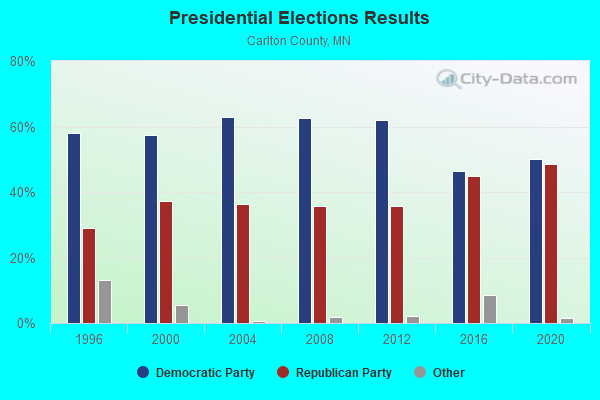
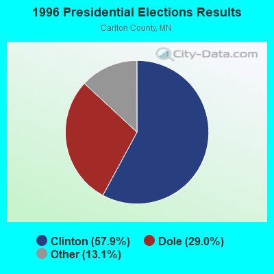
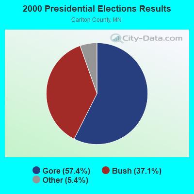
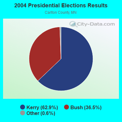
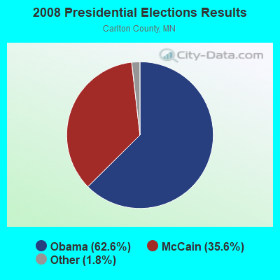
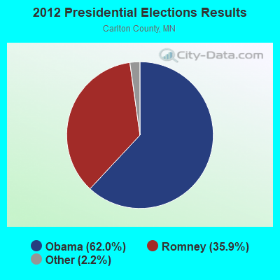
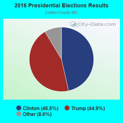
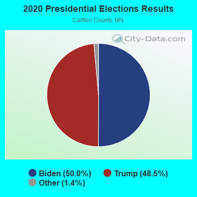
Graphs represent county-level data. Detailed 2008 Election Results
Religion statistics for Thomson, MN (based on Carlton County data)
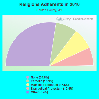
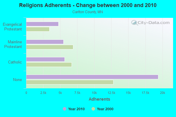
| Religion | Adherents | Congregations |
|---|---|---|
| Catholic | 5,632 | 6 |
| Mainline Protestant | 5,485 | 18 |
| Evangelical Protestant | 4,740 | 30 |
| Other | 138 | 3 |
| None | 19,391 | - |
Food Environment Statistics:
| Carlton County: | 1.19 / 10,000 pop. |
| Minnesota: | 1.83 / 10,000 pop. |
| Here: | 0.30 / 10,000 pop. |
| Minnesota: | 0.13 / 10,000 pop. |
| Carlton County: | 0.30 / 10,000 pop. |
| Minnesota: | 0.49 / 10,000 pop. |
| Here: | 6.54 / 10,000 pop. |
| Minnesota: | 3.90 / 10,000 pop. |
| This county: | 7.14 / 10,000 pop. |
| Minnesota: | 6.98 / 10,000 pop. |
| Carlton County: | 7.3% |
| Minnesota: | 6.5% |
| This county: | 27.2% |
| State: | 25.9% |
| Carlton County: | 10.3% |
| Minnesota: | 13.0% |
| Local government employment and payroll (March 2012) | |||||
| Function | Full-time employees | Monthly full-time payroll | Average yearly full-time wage | Part-time employees | Monthly part-time payroll |
|---|---|---|---|---|---|
| Streets and Highways | 0 | $0 | 1 | $105 | |
| Financial Administration | 0 | $0 | 1 | $700 | |
| Other Government Administration | 0 | $0 | 5 | $1,125 | |
| Totals for Government | 0 | $0 | 7 | $1,930 | |
Thomson government finances - Expenditure in 2012 (per resident):
- Current Operations - Water Utilities: $36,000 ($227.85)
General - Other: $22,000 ($139.24)
Sewerage: $15,000 ($94.94)
Financial Administration: $10,000 ($63.29)
Regular Highways: $7,000 ($44.30)
Local Fire Protection: $6,000 ($37.97)
Health - Other: $2,000 ($12.66)
Protective Inspection and Regulation - Other: $1,000 ($6.33)
- General - Interest on Debt: $10,000 ($63.29)
- Total Salaries and Wages: $22,000 ($139.24)
Thomson government finances - Revenue in 2012 (per resident):
- Charges - Sewerage: $27,000 ($170.89)
- Miscellaneous - General Revenue - Other: $1,000 ($6.33)
Fines and Forfeits: $1,000 ($6.33)
Interest Earnings: $1,000 ($6.33)
- Revenue - Water Utilities: $25,000 ($158.23)
- State Intergovernmental - General Local Government Support: $12,000 ($75.95)
- Tax - Property: $92,000 ($582.28)
Thomson government finances - Debt in 2012 (per resident):
- Long Term Debt - Beginning Outstanding - Unspecified Public Purpose: $247,000 ($1563.29)
Outstanding Unspecified Public Purpose: $231,000 ($1462.03)
Retired Unspecified Public Purpose: $16,000 ($101.27)
Thomson government finances - Cash and Securities in 2012 (per resident):
- Other Funds - Cash and Securities: $43,000 ($272.15)
Strongest AM radio stations in Thomson:
- WEBC (560 AM; 50 kW; DULUTH, MN)
- WWJC (850 AM; daytime; 10 kW; DULUTH, MN; Owner: WWJC, INC.)
- WDSM (710 AM; 10 kW; SUPERIOR, WI; Owner: MIDWEST COMMUNICATIONS, INC.)
- KDAL (610 AM; 5 kW; DULUTH, MN; Owner: MIDWEST COMMUNICATIONS, INC.)
- WKLK (1230 AM; 1 kW; CLOQUET, MN; Owner: QB BROADCASTING, LTD.)
- WGEE (970 AM; 1 kW; SUPERIOR, WI; Owner: MIDWEST COMMUNICATIONS, INC.)
- WCCO (830 AM; 50 kW; MINNEAPOLIS, MN; Owner: INFINITY MEDIA CORPORATION)
- WNMT (650 AM; 10 kW; NASHWAUK, MN; Owner: MIDWEST RADIO NETWORK, L.L.C.)
- WCTS (1030 AM; 50 kW; MAPLEWOOD, MN; Owner: CNTL. BAPT. THEO/AL SEMI MINNEAPOLIS)
- KQDS (1490 AM; 1 kW; DULUTH, MN; Owner: RED ROCK RADIO CORP.)
- KSTP (1500 AM; 50 kW; ST. PAUL, MN; Owner: KSTP-AM, LLC (DELAWARE))
- KFAN (1130 AM; 50 kW; MINNEAPOLIS, MN; Owner: AMFM RADIO LICENSES, L.L.C.)
- KTIS (900 AM; 25 kW; MINNEAPOLIS, MN; Owner: NORTHWESTERN COLLEGE)
Strongest FM radio stations in Thomson:
- WKLK-FM (96.5 FM; CLOQUET, MN; Owner: QB BROADCASTING, LTD.)
- KBMX (107.7 FM; PROCTOR, MN; Owner: REGENT BROADCASTING OF DULUTH, INC.)
- WWAX (92.1 FM; HERMANTOWN, MN; Owner: RED ROCK RADIO CORP.)
- WSCN (100.5 FM; CLOQUET, MN; Owner: MINNESOTA PUBLIC RADIO)
- KLDJ (101.7 FM; DULUTH, MN; Owner: REGENT BROADCASTING OF DULUTH, INC.)
- KDNI (90.5 FM; DULUTH, MN; Owner: NORTHWESTERN COLLEGE)
- KQDS-FM (94.9 FM; DULUTH, MN; Owner: RED ROCK RADIO CORP.)
- KUMD-FM (103.3 FM; DULUTH, MN; Owner: REGENTS OF UNIVERSITY OF MINNESOTA)
- KDAL-FM (95.7 FM; DULUTH, MN; Owner: MIDWEST COMMUNICATIONS, INC.)
- KKCB (105.1 FM; DULUTH, MN; Owner: REGENT BROADCASTING OF DULUTH, INC.)
- KUWS (91.3 FM; SUPERIOR, WI; Owner: BD. OF REGENTS, UNIV. OF WISC. SYS.)
- WSCD-FM (92.9 FM; DULUTH, MN; Owner: MINNESOTA PUBLIC RADIO)
- KRBR-FM (102.5 FM; SUPERIOR, WI; Owner: MIDWEST COMMUNICATIONS, INC.)
- KTCO (98.9 FM; DULUTH, MN; Owner: MIDWEST COMMUNICATIONS, INC.)
- KDNW (97.3 FM; DULUTH, MN; Owner: NORTHWESTERN COLLEGE)
- WNCB (89.5 FM; DULUTH, MN; Owner: REFUGE MEDIA GROUP)
- W203AL (88.5 FM; DULUTH, MN; Owner: FAMILY STATIONS, INC.)
- KZIO (104.3 FM; TWO HARBORS, MN; Owner: RED ROCK RADIO CORP.)
- WMOZ (106.9 FM; MOOSE LAKE, MN; Owner: AGATE BROADCASTING, INC.)
TV broadcast stations around Thomson:
- WDIO-TV (Channel 10; DULUTH, MN; Owner: WDIO-TV, LLC)
- KDLH (Channel 3; DULUTH, MN; Owner: CHELSEY BROADCASTING COMPANY OF DULUTH, LLC)
- KBJR-TV (Channel 6; SUPERIOR, WI; Owner: KBJR LICENSE, INC.)
- KQDS-TV (Channel 21; DULUTH, MN; Owner: KQDS ACQUISITION CORP.)
- WDSE-TV (Channel 8; DULUTH, MN; Owner: DULUTH-SUPERIOR AREA EDUCATIONAL TV CORPORATION)
- K58CM (Channel 58; DULUTH, MN; Owner: TRINITY BROADCASTING NETWORK)
- K38DS (Channel 38; DULUTH, MN; Owner: STEVEN R. ZUKERBERG)
- K62EP (Channel 62; DULUTH, MN; Owner: DAN BLECHMAN)
- K64EF (Channel 64; DULUTH, MN; Owner: STEVEN R. ZUKERBERG)
- K68EA (Channel 68; DULUTH, MN; Owner: MS COMMUNICATIONS, LLC)
- KWMN-LP (Channel 56; DULUTH, MN; Owner: DULUTH DATACASTING PARTNERS, G.P.)
- KDUL-LP (Channel 60; DULUTH, MN; Owner: DULUTH TV PARTNERS, GP)
- K15DU (Channel 15; DULUTH, MN; Owner: DAN BLECHMAN)
- K66EO (Channel 66; DULUTH, MN; Owner: HAROLD AND/ OR SUE KROGMAN)
- National Bridge Inventory (NBI) Statistics
- 6Number of bridges
- 102ft / 31.5mTotal length
- $999,999,000Total costs
- 7,514Total average daily traffic
- 72Total average daily truck traffic
- 7,100Total future (year 2039) average daily traffic
FCC Registered Amateur Radio Licenses:
1- Call Sign: KC9GXK, Licensee ID: L00949345, Grant Date: 10/07/2014, Expiration Date: 12/08/2024, Certifier: Milka J Kleiner, Registrant: Milka J Kleiner, 137 Vermillion St, Thomson, MN 55718
| Home Mortgage Disclosure Act Aggregated Statistics For Year 2009 (Based on 1 partial tract) | ||||||||
| A) FHA, FSA/RHS & VA Home Purchase Loans | B) Conventional Home Purchase Loans | C) Refinancings | D) Home Improvement Loans | |||||
|---|---|---|---|---|---|---|---|---|
| Number | Average Value | Number | Average Value | Number | Average Value | Number | Average Value | |
| LOANS ORIGINATED | 1 | $168,790 | 2 | $154,010 | 11 | $161,867 | 1 | $63,000 |
| APPLICATIONS APPROVED, NOT ACCEPTED | 0 | $0 | 0 | $0 | 1 | $146,530 | 0 | $0 |
| APPLICATIONS DENIED | 0 | $0 | 0 | $0 | 2 | $192,125 | 1 | $24,830 |
| APPLICATIONS WITHDRAWN | 0 | $0 | 0 | $0 | 2 | $167,500 | 0 | $0 |
| FILES CLOSED FOR INCOMPLETENESS | 0 | $0 | 0 | $0 | 1 | $102,220 | 0 | $0 |
Detailed HMDA statistics for the following Tracts: 9703.00
| Private Mortgage Insurance Companies Aggregated Statistics For Year 2009 (Based on 1 partial tract) | ||
| A) Conventional Home Purchase Loans | ||
|---|---|---|
| Number | Average Value | |
| LOANS ORIGINATED | 1 | $118,550 |
| APPLICATIONS APPROVED, NOT ACCEPTED | 0 | $0 |
| APPLICATIONS DENIED | 0 | $0 |
| APPLICATIONS WITHDRAWN | 0 | $0 |
| FILES CLOSED FOR INCOMPLETENESS | 0 | $0 |
Detailed PMIC statistics for the following Tracts: 9703.00


- 53.0%Bottled, tank, or LP gas
- 19.7%Electricity
- 15.2%Fuel oil, kerosene, etc.
- 9.1%Utility gas
- 3.0%Wood

- 100.0%Bottled, tank, or LP gas
Thomson compared to Minnesota state average:
- Unemployed percentage below state average.
- Black race population percentage significantly below state average.
- Hispanic race population percentage significantly below state average.
- Median age above state average.
- Foreign-born population percentage significantly below state average.
- Renting percentage significantly below state average.
- Length of stay since moving in significantly below state average.