Bridge Statistics for Bessemer, Alabama (AL)
Condition, Traffic, Stress, Structural Evaluation, Project Costs
- National Bridge Inventory (NBI) Statistics
- 161Number of bridges
- 2,392ft / 729mTotal length
- $320,452,000Total costs
- 2,593,758Total average daily traffic
- 466,681Total average daily truck traffic
- National Bridge Inventory (NBI) Registered Bridges for Bessemer
- No street view available for this location
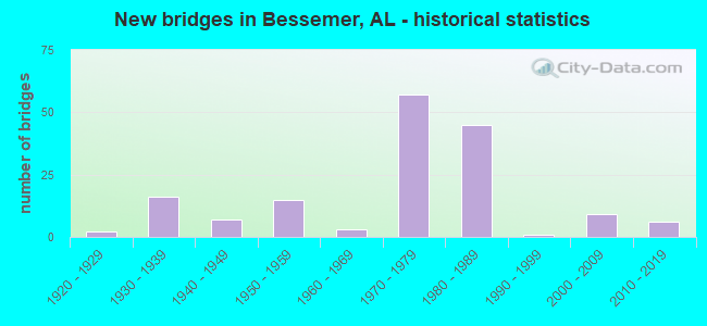
- New bridges - historical statistics
- 21920-1929
- 161930-1939
- 71940-1949
- 151950-1959
- 31960-1969
- 571970-1979
- 451980-1989
- 11990-1999
- 92000-2009
- 62010-2019
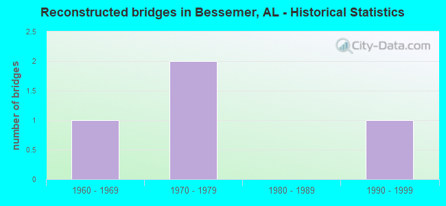
- Reconstructed bridges - Historical Statistics
- 11960-1969
- 21970-1979
- 01980-1989
- 11990-1999
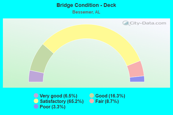
- Bridge Condition - Deck
- 6.5%Very good
- 16.3%Good
- 65.2%Satisfactory
- 8.7%Fair
- 3.3%Poor
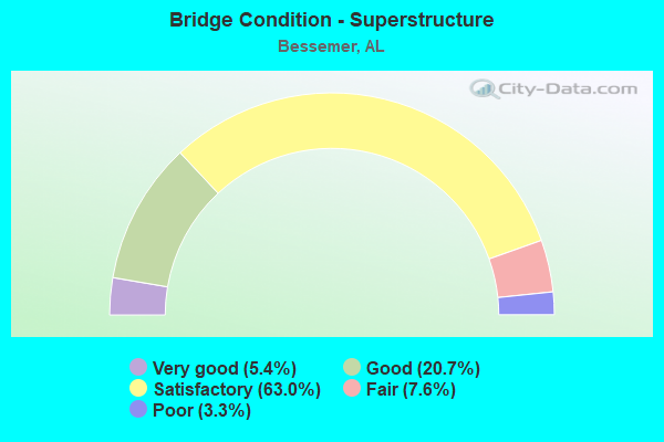
- Bridge Condition - Superstructure
- 5.4%Very good
- 20.7%Good
- 63.0%Satisfactory
- 7.6%Fair
- 3.3%Poor
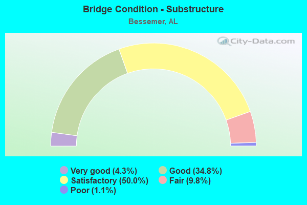
- Bridge Condition - Substructure
- 4.3%Very good
- 34.8%Good
- 50.0%Satisfactory
- 9.8%Fair
- 1.1%Poor
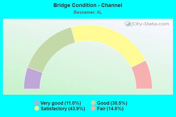
- Bridge Condition - Channel
- 11.0%Very good
- 30.5%Good
- 43.9%Satisfactory
- 14.6%Fair
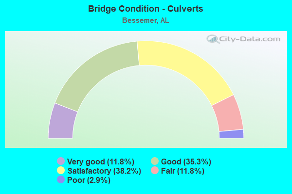
- Bridge Condition - Culverts
- 11.8%Very good
- 35.3%Good
- 38.2%Satisfactory
- 11.8%Fair
- 2.9%Poor
Find on map >> Show street view
Structure Number: 11553, Location: 19 TH ST RELOC (Lat: 33.410147, Lng: -86.968906), Route carried "on" structure: ServiceCity street , Year Built: 1976, Status: Open, Structure Length: 4.39m (14.40ft), Average Daily Traffic: 3,000 (year 2020), Truck Traffic: 5%, Average Future Daily Traffic: 6,000 (year 2040), Design Load: HS 20, Features Intersected: L*N RR, Facility Carried by Structure: 19 TH ST
Minimum Vertical Clearance: 30+ m (98+ ft), Kilometerpoint: 111.800, Lanes on structure: 4, Owner: State Highway Agency, Approaching Roadway Width: 22.6m (74.1ft), Material/Design: Steel continuous, Design/Construction: Stringer/Multi-beam, Number Of Spans In Main Unit: 3, Length of Maximum Span: 15.5m (50.9ft), Curb or Sidewalk Widths: Left: 1.5m (4.9ft), Right: 0.0m, Curb-To-Curb Width: 22.5m (73.8ft), Out-to-Out Width: 24.5m (80.4ft)
Condition: Deck: Satisfactory, Superstructure: Satisfactory, Substructure: Good, Operating Rating: 51.3 metric tons, Method Used To Determine Operating Rating: Load Factor (LF), Inventory Rating: 30.8 metric tons, Method Used To Determine Inventory Rating: Load Factor (LF), Structural Evaluation: Equal to present minimum criteria, Deck Geometry: Superior to present desirable criteria, Underclear: Somewhat better than minimum adequacy, Approach Roadway Alignment: Equal to present desirable criteria, Length Of Structure Improvement: 5.37m (17.62ft), Designated Inspection Frequency: Every 24 months, Inspection Date: March 2020, Bridge Improvement Cost: $2,947,000, Roadway Improvement Cost: $295,000, Total Project Cost: $3,242,000 ( Estimate for 2022), Deck Structure Type: Concrete Cast-file-Place
Find on map >> Show street view
Structure Number: 11737, Location: FIVE MILE CK * I-59 (Lat: 33.347500, Lng: -87.021917), Route carried "on" structure: Interstate 20, Year Built: 1955, Year Reconstructed: 1977, Status: Open, Structure Length: 1.98m (6.50ft), Average Daily Traffic: 43,380 (year 2021), Truck Traffic: 21%, Average Future Daily Traffic: 53,670 (year 2041), Design Load: HS 20, Features Intersected: FIVE MILE CREEK
Minimum Vertical Clearance: 30+ m (98+ ft), Kilometerpoint: 171.556, Lanes on structure: 8, Base Highway Network: Yes, Owner: State Highway Agency, Approaching Roadway Width: 26.8m (87.9ft), Material/Design: Concrete, Design/Construction: Culvert, Number Of Spans In Main Unit: 5, Length of Maximum Span: 3.7m (12.1ft)
Condition: Channel: Satisfactory, Culverts: Satisfactory, Operating Rating: 88.9 metric tons, Method Used To Determine Operating Rating: Load Factor (LF), Inventory Rating: 88.9 metric tons, Method Used To Determine Inventory Rating: Load Factor (LF), Structural Evaluation: Equal to present minimum criteria, Waterway Adequacy: Better than present minimum criteria, Approach Roadway Alignment: Equal to present desirable criteria, Length Of Structure Improvement: 2.73m (8.96ft), Designated Inspection Frequency: Every 24 months, Inspection Date: March 2021, Bridge Improvement Cost: $4,834,000, Roadway Improvement Cost: $483,000, Total Project Cost: $5,317,000 ( Estimate for 2022), Wearing Surface/Protective System: Wearing Surface: Bituminous
Find on map >> Show street view
Structure Number: 11739, Location: I459 * I59 AT MCCALLA (Lat: 33.342967, Lng: -87.028031), Route carried "on" structure: Interstate 459, Year Built: 1977, Status: Open, Structure Length: 9.81m (32.19ft), Average Daily Traffic: 23,500 (year 2020), Truck Traffic: 22%, Average Future Daily Traffic: 29,714 (year 2040), Design Load: HS 20, Features Intersected: I 59
Minimum Vertical Clearance: 30+ m (98+ ft), Kilometerpoint: 0.014, Lanes on structure: 2, Lanes under structure: 4, Base Highway Network: Yes, Owner: State Highway Agency, Approaching Roadway Width: 13.4m (44.0ft), Material/Design: Steel continuous, Design/Construction: Stringer/Multi-beam, Number Of Spans In Main Unit: 4, Length of Maximum Span: 27.1m (88.9ft), Curb-To-Curb Width: 12.0m (39.4ft), Out-to-Out Width: 12.9m (42.3ft)
Condition: Deck: Satisfactory, Superstructure: Satisfactory, Substructure: Satisfactory, Operating Rating: 43.3 metric tons, Method Used To Determine Operating Rating: Load Factor (LF), Inventory Rating: 25.5 metric tons, Method Used To Determine Inventory Rating: Load Factor (LF), Structural Evaluation: Equal to present minimum criteria, Deck Geometry: Equal to present minimum criteria, Underclear: Somewhat better than minimum adequacy, Approach Roadway Alignment: Equal to present desirable criteria, Length Of Structure Improvement: 10.75m (35.27ft), Designated Inspection Frequency: Every 24 months, Inspection Date: December 2020, Bridge Improvement Cost: $3,096,000, Roadway Improvement Cost: $310,000, Total Project Cost: $3,406,000 ( Estimate for 2022), Deck Structure Type: Concrete Cast-file-Place
Find on map >> Show street view
Structure Number: 11741, Location: RAMP 3 TO I459 (Lat: 33.341553, Lng: -87.026217), Route carried "on" structure: Ramp Interstate 459, Year Built: 1977, Status: Open, Structure Length: 1.49m (4.89ft), Average Daily Traffic: 4,700 (year 2022), Truck Traffic: 22%, Average Future Daily Traffic: 5,942 (year 2042), Design Load: HS 20, Features Intersected: STREAM, Facility Carried by Structure: RAMP 3
Minimum Vertical Clearance: 7.56m (24.80ft), Kilometerpoint: 0.161, Lanes on structure: 2, Owner: State Highway Agency, Approaching Roadway Width: 13.4m (44.0ft), Material/Design: Concrete, Design/Construction: Culvert, Number Of Spans In Main Unit: 4, Length of Maximum Span: 2.4m (7.9ft)
Condition: Channel: Good, Culverts: Satisfactory, Operating Rating: 88.9 metric tons, Method Used To Determine Operating Rating: Load Factor (LF), Inventory Rating: 88.9 metric tons, Method Used To Determine Inventory Rating: Load Factor (LF), Structural Evaluation: Equal to present minimum criteria, Waterway Adequacy: Better than present minimum criteria, Approach Roadway Alignment: Equal to present desirable criteria, Length Of Structure Improvement: 2.17m (7.12ft), Designated Inspection Frequency: Every 24 months, Inspection Date: January 2022, Bridge Improvement Cost: $1,728,000, Roadway Improvement Cost: $173,000, Total Project Cost: $1,901,000 ( Estimate for 2022), Wearing Surface/Protective System: Wearing Surface: Bituminous
Find on map >> Show street view
Structure Number: 11742, Location: I 459 * I 59 INTR (Lat: 33.342483, Lng: -87.025556), Route carried "on" structure: Interstate 459, Year Built: 1977, Status: Open, Structure Length: 0.67m (2.20ft), Average Daily Traffic: 47,000 (year 2022), Truck Traffic: 22%, Average Future Daily Traffic: 59,428 (year 2042), Design Load: HS 20, Features Intersected: STREAM
Minimum Vertical Clearance: 30+ m (98+ ft), Kilometerpoint: 0.161, Lanes on structure: 4, Base Highway Network: Yes, Owner: State Highway Agency, Approaching Roadway Width: 17.1m (56.1ft), Skew: 10 degrees, Material/Design: Concrete, Design/Construction: Culvert, Number Of Spans In Main Unit: 2, Length of Maximum Span: 3.0m (9.8ft)
Condition: Channel: Good, Culverts: Good, Operating Rating: 88.9 metric tons, Method Used To Determine Operating Rating: Load Factor (LF), Inventory Rating: 88.9 metric tons, Method Used To Determine Inventory Rating: Load Factor (LF), Structural Evaluation: Better than present minimum criteria, Waterway Adequacy: Equal to present desirable criteria, Approach Roadway Alignment: Equal to present desirable criteria, Length Of Structure Improvement: 1.30m (4.27ft), Designated Inspection Frequency: Every 24 months, Inspection Date: January 2022, Bridge Improvement Cost: $2,147,000, Roadway Improvement Cost: $215,000, Total Project Cost: $2,362,000 ( Estimate for 2022), Wearing Surface/Protective System: Wearing Surface: Bituminous
Find on map >> Show street view
Structure Number: 11748, Location: POWDER PLANT ROAD (Lat: 33.354161, Lng: -87.013800), Route carried "on" structure: County highway , Year Built: 1977, Status: Open, Structure Length: 9.66m (31.69ft), Average Daily Traffic: 24,240 (year 2021), Truck Traffic: 42%, Average Future Daily Traffic: 25,306 (year 2041), Design Load: HS 20, Features Intersected: I - 20/59, Facility Carried by Structure: POWDER PLANT RD
Minimum Vertical Clearance: 30+ m (98+ ft), Kilometerpoint: 0.161, Lanes on structure: 2, Lanes under structure: 4, Owner: State Highway Agency, Approaching Roadway Width: 7.3m (24.0ft), Skew: 3 degrees, Material/Design: Steel continuous, Design/Construction: Stringer/Multi-beam, Number Of Spans In Main Unit: 4, Length of Maximum Span: 27.4m (89.9ft), Curb-To-Curb Width: 13.4m (44.0ft), Out-to-Out Width: 14.3m (46.9ft)
Condition: Deck: Satisfactory, Superstructure: Satisfactory, Substructure: Satisfactory, Operating Rating: 55.2 metric tons, Method Used To Determine Operating Rating: Load Factor (LF), Inventory Rating: 33.0 metric tons, Method Used To Determine Inventory Rating: Load Factor (LF), Structural Evaluation: Equal to present minimum criteria, Deck Geometry: Equal to present minimum criteria, Underclear: Better than present minimum criteria, Approach Roadway Alignment: Better than present minimum criteria, Length Of Structure Improvement: 10.60m (34.78ft), Designated Inspection Frequency: Every 24 months, Inspection Date: July 2021, Bridge Improvement Cost: $3,344,000, Roadway Improvement Cost: $334,000, Total Project Cost: $3,678,000 ( Estimate for 2022), Deck Structure Type: Concrete Cast-file-Place
Find on map >> Show street view
Structure Number: 11749, Location: I59 * DOLONAH ROAD (Lat: 33.395278, Lng: -86.982778), Route carried "on" structure: Interstate 20, Year Built: 1977, Status: Open, Structure Length: 16.61m (54.49ft), Average Daily Traffic: 23,360 (year 2021), Truck Traffic: 21%, Average Future Daily Traffic: 28,901 (year 2041), Design Load: HS 20, Features Intersected: DOLONAH ROAD
Minimum Vertical Clearance: 30+ m (98+ ft), Kilometerpoint: 178.322, Lanes on structure: 2, Lanes under structure: 4, Base Highway Network: Yes, Owner: State Highway Agency, Approaching Roadway Width: 12.2m (40.0ft), Skew: 5 degrees, Material/Design: Steel continuous, Design/Construction: Stringer/Multi-beam, Number Of Spans In Main Unit: 7, Length of Maximum Span: 27.8m (91.2ft), Curb-To-Curb Width: 11.9m (39.0ft), Out-to-Out Width: 12.8m (42.0ft)
Condition: Deck: Satisfactory, Superstructure: Satisfactory, Substructure: Satisfactory, Operating Rating: 48.4 metric tons, Method Used To Determine Operating Rating: Load Factor (LF), Inventory Rating: 28.9 metric tons, Method Used To Determine Inventory Rating: Load Factor (LF), Structural Evaluation: Equal to present minimum criteria, Deck Geometry: Equal to present minimum criteria, Underclear: Meets minimum limits, Approach Roadway Alignment: Equal to present desirable criteria, Length Of Structure Improvement: 17.35m (56.92ft), Designated Inspection Frequency: Every 24 months, Inspection Date: August 2021, Bridge Improvement Cost: $4,996,000, Roadway Improvement Cost: $500,000, Total Project Cost: $5,496,000 ( Estimate for 2022), Deck Structure Type: Concrete Cast-file-Place
Find on map >> Show street view
Structure Number: 1175, Location: I59 * DOLONAH ROAD (Lat: 33.395278, Lng: -86.982778), Route carried "on" structure: Interstate 20, Year Built: 1977, Status: Open, Structure Length: 16.61m (54.49ft), Average Daily Traffic: 23,360 (year 2021), Truck Traffic: 21%, Average Future Daily Traffic: 28,901 (year 2041), Design Load: HS 20, Features Intersected: DOLONAH ROAD
Minimum Vertical Clearance: 30+ m (98+ ft), Kilometerpoint: 178.322, Lanes on structure: 2, Lanes under structure: 4, Base Highway Network: Yes, Owner: State Highway Agency, Approaching Roadway Width: 12.2m (40.0ft), Skew: 5 degrees, Material/Design: Steel continuous, Design/Construction: Stringer/Multi-beam, Number Of Spans In Main Unit: 7, Length of Maximum Span: 27.8m (91.2ft), Curb-To-Curb Width: 11.9m (39.0ft), Out-to-Out Width: 12.8m (42.0ft)
Condition: Deck: Satisfactory, Superstructure: Satisfactory, Substructure: Satisfactory, Operating Rating: 48.1 metric tons, Method Used To Determine Operating Rating: Load Factor (LF), Inventory Rating: 28.8 metric tons, Method Used To Determine Inventory Rating: Load Factor (LF), Structural Evaluation: Equal to present minimum criteria, Deck Geometry: Equal to present minimum criteria, Underclear: Meets minimum limits, Approach Roadway Alignment: Equal to present desirable criteria, Length Of Structure Improvement: 17.34m (56.89ft), Designated Inspection Frequency: Every 24 months, Inspection Date: August 2021, Bridge Improvement Cost: $4,995,000, Roadway Improvement Cost: $500,000, Total Project Cost: $5,495,000 ( Estimate for 2022), Deck Structure Type: Concrete Cast-file-Place
Find on map >> Show street view
Structure Number: 11751, Location: I59 * HALLS CREEK (Lat: 33.398500, Lng: -86.980800), Route carried "on" structure: Interstate 20, Year Built: 1977, Status: Open, Structure Length: 7.38m (24.21ft), Average Daily Traffic: 23,360 (year 2020), Truck Traffic: 21%, Average Future Daily Traffic: 28,901 (year 2040), Design Load: HS 20, Features Intersected: HALLS CREEK
Minimum Vertical Clearance: 30+ m (98+ ft), Kilometerpoint: 178.531, Lanes on structure: 2, Base Highway Network: Yes, Owner: State Highway Agency, Approaching Roadway Width: 12.2m (40.0ft), Material/Design: Steel continuous, Design/Construction: Stringer/Multi-beam, Number Of Spans In Main Unit: 3, Length of Maximum Span: 28.0m (91.9ft), Curb-To-Curb Width: 11.9m (39.0ft), Out-to-Out Width: 12.8m (42.0ft)
Condition: Deck: Satisfactory, Superstructure: Fair, Substructure: Satisfactory, Channel: Good, Operating Rating: 58.1 metric tons, Method Used To Determine Operating Rating: Load Factor (LF), Inventory Rating: 34.8 metric tons, Method Used To Determine Inventory Rating: Load Factor (LF), Structural Evaluation: Somewhat better than minimum adequacy, Deck Geometry: Equal to present minimum criteria, Waterway Adequacy: Equal to present minimum criteria, Approach Roadway Alignment: Equal to present desirable criteria, Length Of Structure Improvement: 8.40m (27.56ft), Designated Inspection Frequency: Every 24 months, Inspection Date: March 2020, Bridge Improvement Cost: $2,420,000, Roadway Improvement Cost: $242,000, Total Project Cost: $2,662,000 ( Estimate for 2022), Deck Structure Type: Concrete Cast-file-Place
Find on map >> Show street view
Structure Number: 11752, Location: I59 * HALLS CREEK (Lat: 33.398400, Lng: -86.980600), Route carried "on" structure: Interstate 20, Year Built: 1977, Status: Open, Structure Length: 7.38m (24.21ft), Average Daily Traffic: 23,360 (year 2020), Truck Traffic: 21%, Average Future Daily Traffic: 28,901 (year 2040), Design Load: HS 20, Features Intersected: HALLS CREEK
Minimum Vertical Clearance: 7.56m (24.80ft), Kilometerpoint: 178.531, Lanes on structure: 2, Base Highway Network: Yes, Owner: State Highway Agency, Approaching Roadway Width: 12.2m (40.0ft), Material/Design: Steel continuous, Design/Construction: Stringer/Multi-beam, Number Of Spans In Main Unit: 3, Length of Maximum Span: 28.0m (91.9ft), Curb-To-Curb Width: 11.9m (39.0ft), Out-to-Out Width: 12.8m (42.0ft)
Condition: Deck: Satisfactory, Superstructure: Satisfactory, Substructure: Satisfactory, Channel: Good, Operating Rating: 58.1 metric tons, Method Used To Determine Operating Rating: Load Factor (LF), Inventory Rating: 34.8 metric tons, Method Used To Determine Inventory Rating: Load Factor (LF), Structural Evaluation: Equal to present minimum criteria, Deck Geometry: Equal to present minimum criteria, Waterway Adequacy: Better than present minimum criteria, Approach Roadway Alignment: Equal to present desirable criteria, Length Of Structure Improvement: 8.40m (27.56ft), Designated Inspection Frequency: Every 24 months, Inspection Date: March 2020, Bridge Improvement Cost: $2,420,000, Roadway Improvement Cost: $242,000, Total Project Cost: $2,662,000 ( Estimate for 2022), Deck Structure Type: Concrete Cast-file-Place
Find on map >> Show street view
Structure Number: 11753, Location: I59 * 11TH ST BESS. (Lat: 33.402778, Lng: -86.977222), Route carried "on" structure: Interstate 20, Year Built: 1977, Status: Open, Structure Length: 5.21m (17.09ft), Average Daily Traffic: 23,360 (year 2021), Truck Traffic: 21%, Average Future Daily Traffic: 28,901 (year 2041), Design Load: HS 20, Features Intersected: 11TH ST BESSEMER
Minimum Vertical Clearance: 30+ m (98+ ft), Kilometerpoint: 179.207, Lanes on structure: 2, Lanes under structure: 2, Base Highway Network: Yes, Owner: State Highway Agency, Approaching Roadway Width: 10.7m (35.1ft), Material/Design: Steel continuous, Design/Construction: Stringer/Multi-beam, Number Of Spans In Main Unit: 3, Length of Maximum Span: 21.3m (69.9ft), Curb-To-Curb Width: 11.9m (39.0ft), Out-to-Out Width: 12.8m (42.0ft)
Condition: Deck: Satisfactory, Superstructure: Satisfactory, Substructure: Good, Operating Rating: 73.5 metric tons, Method Used To Determine Operating Rating: Load Factor (LF), Inventory Rating: 44.0 metric tons, Method Used To Determine Inventory Rating: Load Factor (LF), Structural Evaluation: Equal to present minimum criteria, Deck Geometry: Equal to present minimum criteria, Underclear: Equal to present minimum criteria, Approach Roadway Alignment: Equal to present desirable criteria, Length Of Structure Improvement: 6.23m (20.44ft), Designated Inspection Frequency: Every 24 months, Inspection Date: July 2021, Bridge Improvement Cost: $1,795,000, Roadway Improvement Cost: $180,000, Total Project Cost: $1,975,000 ( Estimate for 2022), Deck Structure Type: Concrete Cast-file-Place
Find on map >> Show street view
Structure Number: 11754, Location: I59 * 11TH ST BESS. (Lat: 33.402778, Lng: -86.977222), Route carried "on" structure: Interstate 20, Year Built: 1977, Status: Open, Structure Length: 5.21m (17.09ft), Average Daily Traffic: 23,360 (year 2021), Truck Traffic: 21%, Average Future Daily Traffic: 28,901 (year 2041), Design Load: HS 20, Features Intersected: 11TH ST BESSEMER
Minimum Vertical Clearance: 30+ m (98+ ft), Kilometerpoint: 179.207, Lanes on structure: 2, Lanes under structure: 2, Base Highway Network: Yes, Owner: State Highway Agency, Approaching Roadway Width: 12.2m (40.0ft), Material/Design: Steel continuous, Design/Construction: Stringer/Multi-beam, Number Of Spans In Main Unit: 3, Length of Maximum Span: 21.3m (69.9ft), Curb-To-Curb Width: 11.9m (39.0ft), Out-to-Out Width: 12.8m (42.0ft)
Condition: Deck: Satisfactory, Superstructure: Satisfactory, Substructure: Good, Operating Rating: 73.5 metric tons, Method Used To Determine Operating Rating: Load Factor (LF), Inventory Rating: 44.0 metric tons, Method Used To Determine Inventory Rating: Load Factor (LF), Structural Evaluation: Equal to present minimum criteria, Deck Geometry: Equal to present minimum criteria, Underclear: Equal to present minimum criteria, Approach Roadway Alignment: Equal to present desirable criteria, Length Of Structure Improvement: 6.23m (20.44ft), Designated Inspection Frequency: Every 24 months, Inspection Date: July 2021, Bridge Improvement Cost: $1,795,000, Roadway Improvement Cost: $180,000, Total Project Cost: $1,975,000 ( Estimate for 2022), Deck Structure Type: Concrete Cast-file-Place
Find on map >> Show street view
Structure Number: 11755, Location: I59 * 15TH ST BESS (Lat: 33.407222, Lng: -86.973611), Route carried "on" structure: Interstate 20, Year Built: 1977, Status: Open, Structure Length: 5.85m (19.19ft), Average Daily Traffic: 23,360 (year 2021), Truck Traffic: 21%, Average Future Daily Traffic: 28,901 (year 2041), Design Load: HS 20, Features Intersected: 15TH ST BESSEMER
Minimum Vertical Clearance: 30+ m (98+ ft), Kilometerpoint: 179.480, Lanes on structure: 3, Lanes under structure: 2, Owner: State Highway Agency, Approaching Roadway Width: 14.9m (48.9ft), Material/Design: Steel continuous, Design/Construction: Stringer/Multi-beam, Number Of Spans In Main Unit: 3, Length of Maximum Span: 25.3m (83.0ft), Curb-To-Curb Width: 15.6m (51.2ft), Out-to-Out Width: 16.5m (54.1ft)
Condition: Deck: Satisfactory, Superstructure: Satisfactory, Substructure: Satisfactory, Operating Rating: 54.0 metric tons, Method Used To Determine Operating Rating: Load Factor (LF), Inventory Rating: 32.4 metric tons, Method Used To Determine Inventory Rating: Load Factor (LF), Structural Evaluation: Equal to present minimum criteria, Deck Geometry: Somewhat better than minimum adequacy, Underclear: Somewhat better than minimum adequacy, Approach Roadway Alignment: Equal to present desirable criteria, Length Of Structure Improvement: 6.89m (22.60ft), Designated Inspection Frequency: Every 24 months, Inspection Date: July 2021, Bridge Improvement Cost: $2,550,000, Roadway Improvement Cost: $255,000, Total Project Cost: $2,805,000 ( Estimate for 2022), Deck Structure Type: Concrete Cast-file-Place
Find on map >> Show street view
Structure Number: 11756, Location: I59 * 15TH ST BESS (Lat: 33.407222, Lng: -86.973611), Route carried "on" structure: Interstate 20, Year Built: 1977, Status: Open, Structure Length: 5.85m (19.19ft), Average Daily Traffic: 23,360 (year 2021), Truck Traffic: 21%, Average Future Daily Traffic: 28,901 (year 2041), Design Load: HS 20, Features Intersected: 15TH ST BESSEMER
Minimum Vertical Clearance: 30+ m (98+ ft), Kilometerpoint: 179.480, Lanes on structure: 3, Lanes under structure: 2, Owner: State Highway Agency, Approaching Roadway Width: 12.2m (40.0ft), Material/Design: Steel continuous, Design/Construction: Stringer/Multi-beam, Number Of Spans In Main Unit: 3, Length of Maximum Span: 25.3m (83.0ft), Curb-To-Curb Width: 11.9m (39.0ft), Out-to-Out Width: 17.1m (56.1ft)
Condition: Deck: Satisfactory, Superstructure: Satisfactory, Substructure: Good, Operating Rating: 45.8 metric tons, Method Used To Determine Operating Rating: Load Factor (LF), Inventory Rating: 27.4 metric tons, Method Used To Determine Inventory Rating: Load Factor (LF), Structural Evaluation: Equal to present minimum criteria, Deck Geometry: High priority of replacement, Underclear: Somewhat better than minimum adequacy, Approach Roadway Alignment: Equal to present desirable criteria, Length Of Structure Improvement: 6.89m (22.60ft), Designated Inspection Frequency: Every 24 months, Inspection Date: July 2021, Bridge Improvement Cost: $2,645,000, Roadway Improvement Cost: $265,000, Total Project Cost: $2,910,000 ( Estimate for 2022), Deck Structure Type: Concrete Cast-file-Place
Find on map >> Show street view
Structure Number: 11757, Location: I 59 * 18TH * 19TH STREET (Lat: 33.410000, Lng: -86.971389), Route carried "on" structure: Interstate 20, Year Built: 1977, Status: Open, Structure Length: 20.09m (65.91ft), Average Daily Traffic: 23,555 (year 2021), Truck Traffic: 17%, Average Future Daily Traffic: 29,142 (year 2041), Design Load: HS 20, Features Intersected: 18TH * 19TH STREETS
Minimum Vertical Clearance: 30+ m (98+ ft), Kilometerpoint: 180.166, Lanes on structure: 2, Lanes under structure: 6, Base Highway Network: Yes (Inventory Route: IN002, Subroute: 59), Owner: State Highway Agency, Approaching Roadway Width: 12.2m (40.0ft), Material/Design: Steel continuous, Design/Construction: Stringer/Multi-beam, Number Of Spans In Main Unit: 9, Length of Maximum Span: 24.4m (80.1ft), Curb-To-Curb Width: 12.0m (39.4ft), Out-to-Out Width: 12.5m (41.0ft)
Condition: Deck: Satisfactory, Superstructure: Satisfactory, Substructure: Satisfactory, Operating Rating: 52.7 metric tons, Method Used To Determine Operating Rating: Load Factor (LF), Inventory Rating: 31.6 metric tons, Method Used To Determine Inventory Rating: Load Factor (LF), Structural Evaluation: Equal to present minimum criteria, Deck Geometry: Equal to present minimum criteria, Underclear: Superior to present desirable criteria, Approach Roadway Alignment: Equal to present desirable criteria, Length Of Structure Improvement: 20.09m (65.91ft), Designated Inspection Frequency: Every 24 months, Inspection Date: September 2021, Bridge Improvement Cost: $5,509,000, Roadway Improvement Cost: $551,000, Total Project Cost: $6,060,000 ( Estimate for 2022), Deck Structure Type: Concrete Cast-file-Place
Find on map >> Show street view
Structure Number: 11758, Location: I59* 18TH * 19TH STS (Lat: 33.410000, Lng: -86.971389), Route carried "on" structure: Interstate 20, Year Built: 1977, Status: Open, Structure Length: 20.09m (65.91ft), Average Daily Traffic: 23,555 (year 2021), Truck Traffic: 17%, Average Future Daily Traffic: 29,142 (year 2041), Design Load: HS 20, Features Intersected: 18TH * 19TH STR
Minimum Vertical Clearance: 30+ m (98+ ft), Kilometerpoint: 180.166, Lanes on structure: 2, Lanes under structure: 6, Base Highway Network: Yes (Inventory Route: IN002, Subroute: 59), Owner: State Highway Agency, Approaching Roadway Width: 12.2m (40.0ft), Material/Design: Steel continuous, Design/Construction: Stringer/Multi-beam, Number Of Spans In Main Unit: 9, Length of Maximum Span: 24.4m (80.1ft), Curb-To-Curb Width: 12.0m (39.4ft), Out-to-Out Width: 12.4m (40.7ft)
Condition: Deck: Satisfactory, Superstructure: Satisfactory, Substructure: Satisfactory, Operating Rating: 55.9 metric tons, Method Used To Determine Operating Rating: Load Factor (LF), Inventory Rating: 33.5 metric tons, Method Used To Determine Inventory Rating: Load Factor (LF), Structural Evaluation: Equal to present minimum criteria, Deck Geometry: Equal to present minimum criteria, Underclear: Superior to present desirable criteria, Approach Roadway Alignment: Equal to present desirable criteria, Length Of Structure Improvement: 20.09m (65.91ft), Designated Inspection Frequency: Every 24 months, Inspection Date: September 2021, Bridge Improvement Cost: $5,509,000, Roadway Improvement Cost: $551,000, Total Project Cost: $6,060,000 ( Estimate for 2022), Deck Structure Type: Concrete Cast-file-Place
Find on map >> Show street view
Structure Number: 11921, Location: RAMP TO I - 59 NO (Lat: 33.343603, Lng: -87.024392), Route carried "on" structure: Ramp Interstate 459, Year Built: 1978, Status: Open, Structure Length: 0.76m (2.49ft), Average Daily Traffic: 4,700 (year 2022), Truck Traffic: 22%, Average Future Daily Traffic: 5,942 (year 2042), Design Load: HS 20, Features Intersected: STREAM
Minimum Vertical Clearance: 30+ m (98+ ft), Kilometerpoint: 0.161, Lanes on structure: 1, Owner: State Highway Agency, Approaching Roadway Width: 11.0m (36.1ft), Material/Design: Concrete, Design/Construction: Culvert, Number Of Spans In Main Unit: 2, Length of Maximum Span: 3.0m (9.8ft)
Condition: Channel: Very good, Culverts: Satisfactory, Operating Rating: 88.9 metric tons, Method Used To Determine Operating Rating: Load Factor (LF), Inventory Rating: 88.9 metric tons, Method Used To Determine Inventory Rating: Load Factor (LF), Structural Evaluation: Equal to present minimum criteria, Waterway Adequacy: Equal to present desirable criteria, Approach Roadway Alignment: Equal to present desirable criteria, Length Of Structure Improvement: 1.41m (4.63ft), Designated Inspection Frequency: Every 24 months, Inspection Date: January 2022, Bridge Improvement Cost: $1,041,000, Roadway Improvement Cost: $104,000, Total Project Cost: $1,145,000 ( Estimate for 2022), Wearing Surface/Protective System: Wearing Surface: Bituminous
Find on map >> Show street view
Structure Number: 11922, Location: 0.1 MI S OLD US 11 (Lat: 33.337494, Lng: -87.011956), Route carried "on" structure: Interstate 459, Year Built: 1978, Status: Open, Structure Length: 1.83m (6.00ft), Average Daily Traffic: 47,000 (year 2022), Truck Traffic: 22%, Average Future Daily Traffic: 59,428 (year 2042), Design Load: HS 20, Features Intersected: STREAM
Minimum Vertical Clearance: 7.56m (24.80ft), Kilometerpoint: 1.529, Lanes on structure: 4, Base Highway Network: Yes, Owner: State Highway Agency, Approaching Roadway Width: 26.8m (87.9ft), Skew: 5 degrees, Material/Design: Concrete, Design/Construction: Culvert, Number Of Spans In Main Unit: 3, Length of Maximum Span: 3.7m (12.1ft)
Condition: Channel: Satisfactory, Culverts: Satisfactory, Operating Rating: 88.9 metric tons, Method Used To Determine Operating Rating: Load Factor (LF), Inventory Rating: 88.9 metric tons, Method Used To Determine Inventory Rating: Load Factor (LF), Structural Evaluation: Equal to present minimum criteria, Waterway Adequacy: Superior to present desirable criteria, Approach Roadway Alignment: Equal to present desirable criteria, Length Of Structure Improvement: 2.54m (8.33ft), Designated Inspection Frequency: Every 24 months, Inspection Date: January 2022, Bridge Improvement Cost: $6,169,000, Roadway Improvement Cost: $617,000, Total Project Cost: $6,786,000 ( Estimate for 2022)
Find on map >> Show street view
Structure Number: 12105, Location: I 59 * CSX RR (Lat: 33.412400, Lng: -86.968300), Route carried "on" structure: Interstate 20, Year Built: 1979, Status: Open, Structure Length: 21.64m (71.00ft), Average Daily Traffic: 23,555 (year 2020), Truck Traffic: 17%, Average Future Daily Traffic: 29,142 (year 2040), Design Load: HS 20, Features Intersected: CSX R.R.
Minimum Vertical Clearance: 30+ m (98+ ft), Kilometerpoint: 180.247, Lanes on structure: 3, Base Highway Network: Yes, Owner: State Highway Agency, Approaching Roadway Width: 15.8m (51.8ft), Material/Design: Steel, Design/Construction: Stringer/Multi-beam, Number Of Spans In Main Unit: 1, Number Of Approach Spans: 8, Length of Maximum Span: 29.9m (98.1ft), Curb-To-Curb Width: 16.3m (53.5ft), Out-to-Out Width: 16.9m (55.4ft)
Condition: Deck: Satisfactory, Superstructure: Satisfactory, Substructure: Satisfactory, Channel: Good, Operating Rating: 57.2 metric tons, Method Used To Determine Operating Rating: Load Factor (LF), Inventory Rating: 34.3 metric tons, Method Used To Determine Inventory Rating: Load Factor (LF), Structural Evaluation: Equal to present minimum criteria, Deck Geometry: Equal to present minimum criteria, Underclear: Equal to present minimum criteria, Waterway Adequacy: Superior to present desirable criteria, Approach Roadway Alignment: Equal to present desirable criteria, Length Of Structure Improvement: 21.64m (71.00ft), Designated Inspection Frequency: Every 24 months, Inspection Date: April 2020, Bridge Improvement Cost: $8,161,000, Roadway Improvement Cost: $816,000, Total Project Cost: $8,977,000 ( Estimate for 2022), Deck Structure Type: Concrete Cast-file-Place
Find on map >> Show street view
Structure Number: 12106, Location: I 59 * L*N RR (Lat: 33.412200, Lng: -86.968200), Route carried "on" structure: Interstate 20, Year Built: 1979, Status: Open, Structure Length: 20.88m (68.50ft), Average Daily Traffic: 23,555 (year 2020), Truck Traffic: 17%, Average Future Daily Traffic: 29,142 (year 2040), Design Load: HS 20, Features Intersected: L& N RR
Minimum Vertical Clearance: 30+ m (98+ ft), Kilometerpoint: 180.247, Lanes on structure: 2, Base Highway Network: Yes, Owner: State Highway Agency, Approaching Roadway Width: 13.4m (44.0ft), Material/Design: Steel, Design/Construction: Stringer/Multi-beam, Number Of Spans In Main Unit: 8, Length of Maximum Span: 29.9m (98.1ft), Curb-To-Curb Width: 12.3m (40.4ft), Out-to-Out Width: 16.3m (53.5ft)
Condition: Deck: Satisfactory, Superstructure: Satisfactory, Substructure: Satisfactory, Channel: Satisfactory, Operating Rating: 54.2 metric tons, Method Used To Determine Operating Rating: Load Factor (LF), Inventory Rating: 32.4 metric tons, Method Used To Determine Inventory Rating: Load Factor (LF), Structural Evaluation: Equal to present minimum criteria, Deck Geometry: Better than present minimum criteria, Underclear: Equal to present minimum criteria, Waterway Adequacy: Better than present minimum criteria, Approach Roadway Alignment: Better than present minimum criteria, Length Of Structure Improvement: 20.88m (68.50ft), Designated Inspection Frequency: Every 24 months, Inspection Date: April 2020, Bridge Improvement Cost: $7,588,000, Roadway Improvement Cost: $759,000, Total Project Cost: $8,347,000 ( Estimate for 2022), Deck Structure Type: Concrete Cast-file-Place
Find on map >> Show street view
Structure Number: 12107, Location: I59 * 24TH ST (Lat: 33.415833, Lng: -86.913611), Route carried "on" structure: Interstate 20, Year Built: 1979, Status: Open, Structure Length: 6.52m (21.39ft), Average Daily Traffic: 23,555 (year 2021), Truck Traffic: 17%, Average Future Daily Traffic: 29,142 (year 2041), Design Load: HS 20, Features Intersected: 24TH ST BESSEMER
Minimum Vertical Clearance: 30+ m (98+ ft), Kilometerpoint: 181.051, Lanes on structure: 2, Lanes under structure: 2, Base Highway Network: Yes, Owner: State Highway Agency, Approaching Roadway Width: 13.4m (44.0ft), Material/Design: Steel continuous, Design/Construction: Stringer/Multi-beam, Number Of Spans In Main Unit: 3, Length of Maximum Span: 25.6m (84.0ft), Curb-To-Curb Width: 12.0m (39.4ft), Out-to-Out Width: 12.5m (41.0ft)
Condition: Deck: Satisfactory, Superstructure: Satisfactory, Substructure: Good, Operating Rating: 68.7 metric tons, Method Used To Determine Operating Rating: Load Factor (LF), Inventory Rating: 41.1 metric tons, Method Used To Determine Inventory Rating: Load Factor (LF), Structural Evaluation: Equal to present minimum criteria, Deck Geometry: Equal to present minimum criteria, Underclear: Equal to present minimum criteria, Approach Roadway Alignment: Equal to present desirable criteria, Length Of Structure Improvement: 7.56m (24.80ft), Designated Inspection Frequency: Every 24 months, Inspection Date: July 2021, Bridge Improvement Cost: $2,125,000, Roadway Improvement Cost: $213,000, Total Project Cost: $2,338,000 ( Estimate for 2022), Deck Structure Type: Concrete Cast-file-Place
Find on map >> Show street view
Structure Number: 12108, Location: I59* 24TH ST (Lat: 33.415833, Lng: -86.913611), Route carried "on" structure: Interstate 20, Year Built: 1979, Status: Open, Structure Length: 6.52m (21.39ft), Average Daily Traffic: 23,555 (year 2021), Truck Traffic: 17%, Average Future Daily Traffic: 29,142 (year 2041), Design Load: HS 20, Features Intersected: 24TH ST BESSEMER
Minimum Vertical Clearance: 30+ m (98+ ft), Kilometerpoint: 181.051, Lanes on structure: 2, Lanes under structure: 2, Base Highway Network: Yes, Owner: State Highway Agency, Approaching Roadway Width: 13.4m (44.0ft), Material/Design: Steel continuous, Design/Construction: Stringer/Multi-beam, Number Of Spans In Main Unit: 3, Length of Maximum Span: 25.6m (84.0ft), Curb-To-Curb Width: 12.0m (39.4ft), Out-to-Out Width: 12.5m (41.0ft)
Condition: Deck: Satisfactory, Superstructure: Satisfactory, Substructure: Good, Operating Rating: 68.7 metric tons, Method Used To Determine Operating Rating: Load Factor (LF), Inventory Rating: 41.1 metric tons, Method Used To Determine Inventory Rating: Load Factor (LF), Structural Evaluation: Equal to present minimum criteria, Deck Geometry: Equal to present minimum criteria, Underclear: Equal to present minimum criteria, Approach Roadway Alignment: Equal to present desirable criteria, Length Of Structure Improvement: 7.56m (24.80ft), Designated Inspection Frequency: Every 24 months, Inspection Date: July 2021, Bridge Improvement Cost: $2,125,000, Roadway Improvement Cost: $213,000, Total Project Cost: $2,338,000 ( Estimate for 2022), Deck Structure Type: Concrete Cast-file-Place
Find on map >> Show street view
Structure Number: 12109, Location: I59 * VALLEY CREEK (Lat: 33.421200, Lng: -86.961000), Route carried "on" structure: Interstate 20, Year Built: 1979, Status: Open, Structure Length: 19.39m (63.62ft), Average Daily Traffic: 23,555 (year 2020), Truck Traffic: 17%, Average Future Daily Traffic: 29,142 (year 2040), Design Load: HS 20, Features Intersected: VALLEY CREEK
Minimum Vertical Clearance: 30+ m (98+ ft), Kilometerpoint: 181.532, Lanes on structure: 2, Lanes under structure: 2, Base Highway Network: Yes, Owner: State Highway Agency, Approaching Roadway Width: 13.4m (44.0ft), Skew: 6 degrees, Material/Design: Steel continuous, Design/Construction: Stringer/Multi-beam, Number Of Spans In Main Unit: 3, Number Of Approach Spans: 4, Length of Maximum Span: 36.6m (120.1ft), Curb-To-Curb Width: 12.0m (39.4ft), Out-to-Out Width: 13.1m (43.0ft)
Condition: Deck: Satisfactory, Superstructure: Satisfactory, Substructure: Satisfactory, Channel: Fair, Operating Rating: 55.3 metric tons, Method Used To Determine Operating Rating: Load Factor (LF), Inventory Rating: 33.1 metric tons, Method Used To Determine Inventory Rating: Load Factor (LF), Structural Evaluation: Equal to present minimum criteria, Deck Geometry: Equal to present minimum criteria, Underclear: Equal to present minimum criteria, Waterway Adequacy: Better than present minimum criteria, Approach Roadway Alignment: Equal to present desirable criteria, Length Of Structure Improvement: 19.97m (65.52ft), Designated Inspection Frequency: Every 24 months, Inspection Date: April 2020, Bridge Improvement Cost: $5,889,000, Roadway Improvement Cost: $589,000, Total Project Cost: $6,478,000 ( Estimate for 2022), Deck Structure Type: Concrete Cast-file-Place
Find on map >> Show street view
Structure Number: 1211, Location: I59 * VALLEY CREEK (Lat: 33.419600, Lng: -86.961700), Route carried "on" structure: Interstate 20, Year Built: 1979, Status: Open, Structure Length: 19.39m (63.62ft), Average Daily Traffic: 23,555 (year 2020), Truck Traffic: 17%, Average Future Daily Traffic: 29,142 (year 2040), Design Load: HS 20, Features Intersected: VALLEY CREEK
Minimum Vertical Clearance: 7.56m (24.80ft), Kilometerpoint: 181.532, Lanes on structure: 2, Lanes under structure: 2, Base Highway Network: Yes, Owner: State Highway Agency, Approaching Roadway Width: 13.4m (44.0ft), Skew: 2 degrees, Material/Design: Steel continuous, Design/Construction: Stringer/Multi-beam, Number Of Spans In Main Unit: 3, Number Of Approach Spans: 4, Length of Maximum Span: 36.6m (120.1ft), Curb-To-Curb Width: 12.0m (39.4ft), Out-to-Out Width: 13.1m (43.0ft)
Condition: Deck: Satisfactory, Superstructure: Satisfactory, Substructure: Satisfactory, Channel: Fair, Operating Rating: 53.3 metric tons, Method Used To Determine Operating Rating: Load Factor (LF), Inventory Rating: 31.9 metric tons, Method Used To Determine Inventory Rating: Load Factor (LF), Structural Evaluation: Equal to present minimum criteria, Deck Geometry: Equal to present minimum criteria, Underclear: Equal to present minimum criteria, Waterway Adequacy: Equal to present desirable criteria, Approach Roadway Alignment: Equal to present desirable criteria, Length Of Structure Improvement: 19.97m (65.52ft), Designated Inspection Frequency: Every 24 months, Inspection Date: April 2020, Bridge Improvement Cost: $5,889,000, Roadway Improvement Cost: $589,000, Total Project Cost: $6,478,000 ( Estimate for 2022), Deck Structure Type: Concrete Cast-file-Place
Find on map >> Show street view
Structure Number: 12111, Location: I59 * WOODWARD RR (Lat: 33.422222, Lng: -86.959722), Route carried "on" structure: Interstate 20, Year Built: 1979, Status: Open, Structure Length: 5.46m (17.91ft), Average Daily Traffic: 23,555 (year 2020), Truck Traffic: 17%, Average Future Daily Traffic: 29,142 (year 2040), Design Load: HS 20, Features Intersected: WOODWARD RAILROAD
Minimum Vertical Clearance: 30+ m (98+ ft), Kilometerpoint: 181.967, Lanes on structure: 2, Base Highway Network: Yes, Owner: State Highway Agency, Approaching Roadway Width: 13.4m (44.0ft), Skew: 3 degrees, Material/Design: Steel continuous, Design/Construction: Stringer/Multi-beam, Number Of Spans In Main Unit: 3, Length of Maximum Span: 20.4m (66.9ft), Curb-To-Curb Width: 12.2m (40.0ft), Out-to-Out Width: 13.0m (42.7ft)
Condition: Deck: Satisfactory, Superstructure: Satisfactory, Substructure: Satisfactory, Operating Rating: 78.6 metric tons, Method Used To Determine Operating Rating: Load Factor (LF), Inventory Rating: 47.1 metric tons, Method Used To Determine Inventory Rating: Load Factor (LF), Structural Evaluation: Equal to present minimum criteria, Deck Geometry: Better than present minimum criteria, Underclear: Superior to present desirable criteria, Approach Roadway Alignment: Better than present minimum criteria, Length Of Structure Improvement: 6.49m (21.29ft), Designated Inspection Frequency: Every 24 months, Inspection Date: March 2020, Bridge Improvement Cost: $1,869,000, Roadway Improvement Cost: $187,000, Total Project Cost: $2,056,000 ( Estimate for 2022), Deck Structure Type: Concrete Cast-file-Place
Find on map >> Show street view
Structure Number: 12112, Location: I59 * WOODWARD RR (Lat: 33.422222, Lng: -86.959722), Route carried "on" structure: Interstate 20, Year Built: 1979, Status: Open, Structure Length: 5.46m (17.91ft), Average Daily Traffic: 23,555 (year 2020), Truck Traffic: 17%, Average Future Daily Traffic: 29,142 (year 2040), Design Load: HS 20, Features Intersected: WOODWARD RAILROAD
Minimum Vertical Clearance: 30+ m (98+ ft), Kilometerpoint: 181.967, Lanes on structure: 2, Base Highway Network: Yes, Owner: State Highway Agency, Approaching Roadway Width: 13.4m (44.0ft), Skew: 6 degrees, Material/Design: Steel continuous, Design/Construction: Stringer/Multi-beam, Number Of Spans In Main Unit: 3, Length of Maximum Span: 20.4m (66.9ft), Curb-To-Curb Width: 12.2m (40.0ft), Out-to-Out Width: 13.0m (42.7ft)
Condition: Deck: Satisfactory, Superstructure: Satisfactory, Substructure: Good, Operating Rating: 73.7 metric tons, Method Used To Determine Operating Rating: Load Factor (LF), Inventory Rating: 44.1 metric tons, Method Used To Determine Inventory Rating: Load Factor (LF), Structural Evaluation: Equal to present minimum criteria, Deck Geometry: Better than present minimum criteria, Underclear: Superior to present desirable criteria, Approach Roadway Alignment: Equal to present desirable criteria, Length Of Structure Improvement: 6.49m (21.29ft), Designated Inspection Frequency: Every 24 months, Inspection Date: March 2020, Bridge Improvement Cost: $1,869,000, Roadway Improvement Cost: $187,000, Total Project Cost: $2,056,000 ( Estimate for 2022), Deck Structure Type: Concrete Cast-file-Place
Find on map >> Show street view
Structure Number: 12113, Location: I59 * 18TH AVE (Lat: 33.426111, Lng: -86.955000), Route carried "on" structure: Interstate 20, Year Built: 1979, Status: Open, Structure Length: 11.31m (37.11ft), Average Daily Traffic: 27,105 (year 2021), Truck Traffic: 16%, Average Future Daily Traffic: 33,534 (year 2041), Design Load: HS 20, Features Intersected: 18TH AVE BESSEMER
Minimum Vertical Clearance: 7.56m (24.80ft), Kilometerpoint: 182.564, Lanes on structure: 2, Lanes under structure: 4, Base Highway Network: Yes (Inventory Route: IN002, Subroute: 59), Owner: State Highway Agency, Approaching Roadway Width: 13.4m (44.0ft), Skew: 2 degrees, Material/Design: Steel continuous, Design/Construction: Stringer/Multi-beam, Number Of Spans In Main Unit: 3, Length of Maximum Span: 43.3m (142.1ft), Curb-To-Curb Width: 12.0m (39.4ft), Out-to-Out Width: 12.9m (42.3ft)
Condition: Deck: Satisfactory, Superstructure: Satisfactory, Substructure: Satisfactory, Operating Rating: 49.5 metric tons, Method Used To Determine Operating Rating: Load Factor (LF), Inventory Rating: 29.7 metric tons, Method Used To Determine Inventory Rating: Load Factor (LF), Structural Evaluation: Equal to present minimum criteria, Deck Geometry: Equal to present minimum criteria, Underclear: Meets minimum limits, Approach Roadway Alignment: Equal to present desirable criteria, Length Of Structure Improvement: 12.19m (39.99ft), Designated Inspection Frequency: Every 24 months, Inspection Date: July 2021, Bridge Improvement Cost: $3,510,000, Roadway Improvement Cost: $351,000, Total Project Cost: $3,861,000 ( Estimate for 2022), Deck Structure Type: Concrete Cast-file-Place
Find on map >> Show street view
Structure Number: 12114, Location: I59 * 18TH AVE (Lat: 33.426111, Lng: -86.955000), Route carried "on" structure: Interstate 20, Year Built: 1979, Status: Open, Structure Length: 11.31m (37.11ft), Average Daily Traffic: 27,105 (year 2021), Truck Traffic: 16%, Average Future Daily Traffic: 33,534 (year 2041), Design Load: HS 20, Features Intersected: 18TH AVE BESSEMER
Minimum Vertical Clearance: 7.56m (24.80ft), Kilometerpoint: 182.564, Lanes on structure: 2, Lanes under structure: 4, Base Highway Network: Yes, Owner: State Highway Agency, Approaching Roadway Width: 13.4m (44.0ft), Skew: 5 degrees, Material/Design: Steel continuous, Design/Construction: Stringer/Multi-beam, Number Of Spans In Main Unit: 3, Length of Maximum Span: 43.3m (142.1ft), Curb-To-Curb Width: 12.0m (39.4ft), Out-to-Out Width: 12.9m (42.3ft)
Condition: Deck: Satisfactory, Superstructure: Satisfactory, Substructure: Satisfactory, Operating Rating: 36.2 metric tons, Method Used To Determine Operating Rating: Load Factor (LF), Inventory Rating: 21.7 metric tons, Method Used To Determine Inventory Rating: Load Factor (LF), Structural Evaluation: Somewhat better than minimum adequacy, Deck Geometry: Equal to present minimum criteria, Underclear: Meets minimum limits, Approach Roadway Alignment: Equal to present desirable criteria, Length Of Structure Improvement: 12.19m (39.99ft), Designated Inspection Frequency: Every 24 months, Inspection Date: July 2021, Bridge Improvement Cost: $3,510,000, Roadway Improvement Cost: $351,000, Total Project Cost: $3,861,000 ( Estimate for 2022), Deck Structure Type: Concrete Cast-file-Place
Find on map >> Show street view
Structure Number: 12115, Location: I59 * ABANDONED RR (Lat: 33.430833, Lng: -86.953333), Route carried "on" structure: Interstate 20, Year Built: 1979, Status: Open, Structure Length: 6.10m (20.01ft), Average Daily Traffic: 27,105 (year 2021), Truck Traffic: 16%, Average Future Daily Traffic: 33,534 (year 2041), Design Load: HS 20, Features Intersected: ABANDONED RR
Minimum Vertical Clearance: 30+ m (98+ ft), Kilometerpoint: 183.174, Lanes on structure: 2, Base Highway Network: Yes, Owner: State Highway Agency, Approaching Roadway Width: 13.4m (44.0ft), Skew: 6 degrees, Material/Design: Steel continuous, Design/Construction: Stringer/Multi-beam, Number Of Spans In Main Unit: 3, Length of Maximum Span: 29.0m (95.1ft), Curb-To-Curb Width: 12.8m (42.0ft), Out-to-Out Width: 14.0m (45.9ft)
Condition: Deck: Satisfactory, Superstructure: Satisfactory, Substructure: Satisfactory, Operating Rating: 66.4 metric tons, Method Used To Determine Operating Rating: Load Factor (LF), Inventory Rating: 39.8 metric tons, Method Used To Determine Inventory Rating: Load Factor (LF), Structural Evaluation: Equal to present minimum criteria, Deck Geometry: Equal to present desirable criteria, Approach Roadway Alignment: Better than present minimum criteria, Length Of Structure Improvement: 7.14m (23.43ft), Designated Inspection Frequency: Every 24 months, Inspection Date: June 2021, Bridge Improvement Cost: $2,203,000, Roadway Improvement Cost: $220,000, Total Project Cost: $2,423,000 ( Estimate for 2022), Deck Structure Type: Concrete Cast-file-Place
Find on map >> Show street view
Structure Number: 12116, Location: I59 * ABANDONED RR (Lat: 33.430833, Lng: -86.953333), Route carried "on" structure: Interstate 20, Year Built: 1979, Status: Open, Structure Length: 6.10m (20.01ft), Average Daily Traffic: 27,105 (year 2021), Truck Traffic: 16%, Average Future Daily Traffic: 33,534 (year 2041), Design Load: HS 20, Features Intersected: ABANDONED RRLROAD
Minimum Vertical Clearance: 30+ m (98+ ft), Kilometerpoint: 183.174, Lanes on structure: 2, Base Highway Network: Yes, Owner: State Highway Agency, Approaching Roadway Width: 13.4m (44.0ft), Skew: 6 degrees, Material/Design: Steel continuous, Design/Construction: Stringer/Multi-beam, Number Of Spans In Main Unit: 3, Length of Maximum Span: 29.0m (95.1ft), Curb-To-Curb Width: 15.8m (51.8ft), Out-to-Out Width: 17.1m (56.1ft)
Condition: Deck: Satisfactory, Superstructure: Satisfactory, Substructure: Satisfactory, Operating Rating: 66.2 metric tons, Method Used To Determine Operating Rating: Load Factor (LF), Inventory Rating: 39.6 metric tons, Method Used To Determine Inventory Rating: Load Factor (LF), Structural Evaluation: Equal to present minimum criteria, Deck Geometry: Superior to present desirable criteria, Approach Roadway Alignment: Equal to present desirable criteria, Length Of Structure Improvement: 7.14m (23.43ft), Designated Inspection Frequency: Every 24 months, Inspection Date: June 2021, Bridge Improvement Cost: $2,741,000, Roadway Improvement Cost: $274,000, Total Project Cost: $3,015,000 ( Estimate for 2022), Deck Structure Type: Concrete Cast-file-Place
Find on map >> Show street view
Structure Number: 12308, Location: I59 * WOODWARD RD (Lat: 33.436389, Lng: -86.954722), Route carried "on" structure: Interstate 20, Year Built: 1980, Status: Open, Structure Length: 7.38m (24.21ft), Average Daily Traffic: 27,105 (year 2021), Truck Traffic: 16%, Average Future Daily Traffic: 33,534 (year 2041), Design Load: HS 20, Features Intersected: WOODWARD ROAD
Minimum Vertical Clearance: 30+ m (98+ ft), Kilometerpoint: 183.826, Lanes on structure: 2, Lanes under structure: 4, Base Highway Network: Yes, Owner: State Highway Agency, Approaching Roadway Width: 12.2m (40.0ft), Skew: 8 degrees, Material/Design: Steel continuous, Design/Construction: Stringer/Multi-beam, Number Of Spans In Main Unit: 3, Length of Maximum Span: 29.3m (96.1ft), Curb-To-Curb Width: 12.2m (40.0ft), Out-to-Out Width: 13.9m (45.6ft)
Condition: Deck: Satisfactory, Superstructure: Satisfactory, Substructure: Satisfactory, Operating Rating: 54.7 metric tons, Method Used To Determine Operating Rating: Load Factor (LF), Inventory Rating: 32.7 metric tons, Method Used To Determine Inventory Rating: Load Factor (LF), Structural Evaluation: Equal to present minimum criteria, Deck Geometry: Better than present minimum criteria, Underclear: Superior to present desirable criteria, Approach Roadway Alignment: Equal to present desirable criteria, Length Of Structure Improvement: 8.40m (27.56ft), Designated Inspection Frequency: Every 24 months, Inspection Date: July 2021, Bridge Improvement Cost: $2,593,000, Roadway Improvement Cost: $259,000, Total Project Cost: $2,852,000 ( Estimate for 2022), Deck Structure Type: Concrete Cast-file-Place
Find on map >> Show street view
Structure Number: 12309, Location: I59 * WOODWARD ROAD (Lat: 33.437500, Lng: -86.954722), Route carried "on" structure: Interstate 20, Year Built: 1980, Status: Open, Structure Length: 7.38m (24.21ft), Average Daily Traffic: 27,105 (year 2021), Truck Traffic: 16%, Average Future Daily Traffic: 33,534 (year 2041), Design Load: HS 20, Features Intersected: WOODWARD ROAD
Minimum Vertical Clearance: 30+ m (98+ ft), Kilometerpoint: 183.826, Lanes on structure: 2, Lanes under structure: 4, Base Highway Network: Yes, Owner: State Highway Agency, Approaching Roadway Width: 12.2m (40.0ft), Material/Design: Steel continuous, Design/Construction: Stringer/Multi-beam, Number Of Spans In Main Unit: 3, Length of Maximum Span: 29.3m (96.1ft), Curb-To-Curb Width: 12.2m (40.0ft), Out-to-Out Width: 13.9m (45.6ft)
Condition: Deck: Satisfactory, Superstructure: Satisfactory, Substructure: Satisfactory, Operating Rating: 54.7 metric tons, Method Used To Determine Operating Rating: Load Factor (LF), Inventory Rating: 32.7 metric tons, Method Used To Determine Inventory Rating: Load Factor (LF), Structural Evaluation: Equal to present minimum criteria, Deck Geometry: Better than present minimum criteria, Underclear: Superior to present desirable criteria, Approach Roadway Alignment: Equal to present desirable criteria, Length Of Structure Improvement: 8.40m (27.56ft), Designated Inspection Frequency: Every 24 months, Inspection Date: July 2021, Bridge Improvement Cost: $2,593,000, Roadway Improvement Cost: $259,000, Total Project Cost: $2,852,000 ( Estimate for 2022), Deck Structure Type: Concrete Cast-file-Place
Find on map >> Show street view
Structure Number: 12446, Location: JONESBORO (Lat: 33.374225, Lng: -86.964236), Route carried "on" structure: County highway 112, Year Built: 1980, Status: Open, Structure Length: 0.84m (2.76ft), Average Daily Traffic: 4,700 (year 2021), Truck Traffic: 5%, Average Future Daily Traffic: 6,525 (year 2041), Design Load: HS 20, Features Intersected: HALLS CREEK, Facility Carried by Structure: DIVISION STREET
Minimum Vertical Clearance: 30+ m (98+ ft), Kilometerpoint: 0.010, Lanes on structure: 2, Owner: City or Municipal Highway Agency, Approaching Roadway Width: 6.0m (19.7ft), Skew: 3 degrees, Material/Design: Concrete continuous, Design/Construction: Slab, Number Of Spans In Main Unit: 2, Length of Maximum Span: 3.5m (11.5ft), Curb or Sidewalk Widths: Left: 0.3m (1.0ft), Right: 0.3m (1.0ft), Curb-To-Curb Width: 10.2m (33.5ft), Out-to-Out Width: 10.8m (35.4ft)
Condition: Deck: Satisfactory, Superstructure: Satisfactory, Substructure: Satisfactory, Channel: Satisfactory, Operating Rating: 32.7 metric tons, Method Used To Determine Operating Rating: Field evaluation and documented engineering judgment, Inventory Rating: 23.6 metric tons, Method Used To Determine Inventory Rating: Field evaluation and documented engineering judgment, Structural Evaluation: Equal to present minimum criteria, Deck Geometry: Meets minimum limits, Waterway Adequacy: Equal to present minimum criteria, Approach Roadway Alignment: Better than present minimum criteria, Length Of Structure Improvement: 1.50m (4.92ft), Designated Inspection Frequency: Every 24 months, Inspection Date: July 2021, Bridge Improvement Cost: $360,000, Roadway Improvement Cost: $36,000, Total Project Cost: $396,000 ( Estimate for 2022), Deck Structure Type: Concrete Cast-file-Place, Wearing Surface/Protective System: Wearing Surface: Bituminous
Find on map >> Show street view
Structure Number: 12589, Location: 1 MI NE MCCALLA (Lat: 33.343250, Lng: -87.012833), Route carried "on" structure: County highway 47, Year Built: 1981, Status: Open, Structure Length: 3.18m (10.43ft), Average Daily Traffic: 2,500 (year 2021), Truck Traffic: 5%, Average Future Daily Traffic: 3,500 (year 2041), Design Load: HS 20, Features Intersected: MOORES BROOK, Facility Carried by Structure: POWDER PLANT ROAD
Minimum Vertical Clearance: 30+ m (98+ ft), Kilometerpoint: 0.010, Lanes on structure: 2, Owner: County Highway Agency, Approaching Roadway Width: 6.5m (21.3ft), Skew: 1 degrees, Material/Design: Prestressed concrete, Design/Construction: Box Beam or Girders - Multiple, Number Of Spans In Main Unit: 2, Length of Maximum Span: 15.2m (49.9ft), Curb or Sidewalk Widths: Left: 0.3m (1.0ft), Right: 0.3m (1.0ft), Curb-To-Curb Width: 8.8m (28.9ft), Out-to-Out Width: 9.8m (32.2ft)
Condition: Deck: Good, Superstructure: Good, Substructure: Satisfactory, Channel: Satisfactory, Operating Rating: 45.4 metric tons, Method Used To Determine Operating Rating: Load Factor (LF), Inventory Rating: 25.9 metric tons, Method Used To Determine Inventory Rating: Load Factor (LF), Structural Evaluation: Equal to present minimum criteria, Deck Geometry: Meets minimum limits, Waterway Adequacy: Equal to present minimum criteria, Approach Roadway Alignment: Better than present minimum criteria, Length Of Structure Improvement: 4.04m (13.25ft), Designated Inspection Frequency: Every 24 months, Inspection Date: November 2021, Bridge Improvement Cost: $886,000, Roadway Improvement Cost: $89,000, Total Project Cost: $975,000 ( Estimate for 2022), Deck Structure Type: Concrete Precast Panels, Wearing Surface/Protective System: Wearing Surface: Bituminous
Find on map >> Show street view
Structure Number: 1259, Location: 1 MI NE OF MCCALLA (Lat: 33.338683, Lng: -87.009400), Route carried "on" structure: County highway 47, Year Built: 1981, Status: Open, Structure Length: 1.92m (6.30ft), Average Daily Traffic: 2,500 (year 2021), Truck Traffic: 5%, Average Future Daily Traffic: 3,500 (year 2041), Design Load: HS 20, Features Intersected: MOORES BRANCH, Facility Carried by Structure: POWDER PLANT RD
Minimum Vertical Clearance: 30+ m (98+ ft), Kilometerpoint: 0.010, Lanes on structure: 2, Owner: County Highway Agency, Approaching Roadway Width: 6.7m (22.0ft), Material/Design: Prestressed concrete, Design/Construction: Box Beam or Girders - Multiple, Number Of Spans In Main Unit: 1, Length of Maximum Span: 18.3m (60.0ft), Curb or Sidewalk Widths: Left: 0.3m (1.0ft), Right: 0.3m (1.0ft), Curb-To-Curb Width: 9.9m (32.5ft), Out-to-Out Width: 10.8m (35.4ft)
Condition: Deck: Good, Superstructure: Satisfactory, Substructure: Satisfactory, Channel: Satisfactory, Operating Rating: 45.0 metric tons, Method Used To Determine Operating Rating: Load Factor (LF), Inventory Rating: 26.9 metric tons, Method Used To Determine Inventory Rating: Load Factor (LF), Structural Evaluation: Equal to present minimum criteria, Deck Geometry: Meets minimum limits, Waterway Adequacy: Equal to present minimum criteria, Approach Roadway Alignment: Better than present minimum criteria, Length Of Structure Improvement: 2.65m (8.69ft), Designated Inspection Frequency: Every 24 months, Inspection Date: November 2021, Bridge Improvement Cost: $637,000, Roadway Improvement Cost: $64,000, Total Project Cost: $701,000 ( Estimate for 2022), Deck Structure Type: Concrete Precast Panels, Wearing Surface/Protective System: Wearing Surface: Bituminous
Find on map >> Show street view
Structure Number: 12695, Location: I459 * OLD US11 (Lat: 33.337133, Lng: -87.010447), Route carried "on" structure: Interstate 459, Year Built: 1982, Status: Open, Structure Length: 8.04m (26.38ft), Average Daily Traffic: 23,500 (year 2020), Truck Traffic: 22%, Average Future Daily Traffic: 29,714 (year 2040), Design Load: HS 20, Features Intersected: OLD US 11
Minimum Vertical Clearance: 30+ m (98+ ft), Kilometerpoint: 1.770, Lanes on structure: 2, Lanes under structure: 2, Base Highway Network: Yes, Owner: State Highway Agency, Approaching Roadway Width: 13.4m (44.0ft), Skew: 3 degrees, Material/Design: Steel continuous, Design/Construction: Stringer/Multi-beam, Number Of Spans In Main Unit: 3, Length of Maximum Span: 30.5m (100.1ft), Curb-To-Curb Width: 12.2m (40.0ft), Out-to-Out Width: 13.4m (44.0ft)
Condition: Deck: Satisfactory, Superstructure: Good, Substructure: Good, Operating Rating: 44.3 metric tons, Method Used To Determine Operating Rating: Load Factor (LF), Inventory Rating: 26.6 metric tons, Method Used To Determine Inventory Rating: Load Factor (LF), Structural Evaluation: Equal to present minimum criteria, Deck Geometry: Better than present minimum criteria, Underclear: Better than present minimum criteria, Approach Roadway Alignment: Equal to present desirable criteria, Length Of Structure Improvement: 9.05m (29.69ft), Designated Inspection Frequency: Every 24 months, Inspection Date: October 2020, Bridge Improvement Cost: $2,730,000, Roadway Improvement Cost: $273,000, Total Project Cost: $3,003,000 ( Estimate for 2022), Deck Structure Type: Concrete Cast-file-Place
Find on map >> Show street view
Structure Number: 12696, Location: I459 * OLD US11 (Lat: 33.336969, Lng: -87.010714), Route carried "on" structure: Interstate 459, Year Built: 1982, Status: Open, Structure Length: 8.04m (26.38ft), Average Daily Traffic: 23,500 (year 2020), Truck Traffic: 22%, Average Future Daily Traffic: 29,714 (year 2040), Design Load: HS 20, Features Intersected: OLD US 11
Minimum Vertical Clearance: 30+ m (98+ ft), Kilometerpoint: 1.770, Lanes on structure: 2, Lanes under structure: 2, Base Highway Network: Yes, Owner: State Highway Agency, Approaching Roadway Width: 13.4m (44.0ft), Skew: 3 degrees, Material/Design: Steel continuous, Design/Construction: Stringer/Multi-beam, Number Of Spans In Main Unit: 3, Length of Maximum Span: 30.5m (100.1ft), Curb-To-Curb Width: 12.2m (40.0ft), Out-to-Out Width: 13.4m (44.0ft)
Condition: Deck: Satisfactory, Superstructure: Satisfactory, Substructure: Good, Operating Rating: 44.3 metric tons, Method Used To Determine Operating Rating: Load Factor (LF), Inventory Rating: 26.6 metric tons, Method Used To Determine Inventory Rating: Load Factor (LF), Structural Evaluation: Equal to present minimum criteria, Deck Geometry: Better than present minimum criteria, Underclear: Better than present minimum criteria, Approach Roadway Alignment: Equal to present desirable criteria, Length Of Structure Improvement: 9.05m (29.69ft), Designated Inspection Frequency: Every 24 months, Inspection Date: October 2020, Bridge Improvement Cost: $2,730,000, Roadway Improvement Cost: $273,000, Total Project Cost: $3,003,000 ( Estimate for 2022), Deck Structure Type: Concrete Cast-file-Place
Find on map >> Show street view
Structure Number: 12697, Location: I 459 * SOU RR (Lat: 33.335956, Lng: -87.007181), Route carried "on" structure: Interstate 459, Year Built: 1982, Status: Open, Structure Length: 6.20m (20.34ft), Average Daily Traffic: 23,500 (year 2020), Truck Traffic: 22%, Average Future Daily Traffic: 29,714 (year 2040), Design Load: HS 20, Features Intersected: SOU RR
Minimum Vertical Clearance: 30+ m (98+ ft), Kilometerpoint: 1.983, Lanes on structure: 2, Base Highway Network: Yes, Owner: State Highway Agency, Approaching Roadway Width: 13.4m (44.0ft), Skew: 1 degrees, Material/Design: Steel continuous, Design/Construction: Stringer/Multi-beam, Number Of Spans In Main Unit: 3, Length of Maximum Span: 24.4m (80.1ft), Curb-To-Curb Width: 12.2m (40.0ft), Out-to-Out Width: 13.4m (44.0ft)
Condition: Deck: Good, Superstructure: Good, Substructure: Satisfactory, Operating Rating: 55.7 metric tons, Method Used To Determine Operating Rating: Load Factor (LF), Inventory Rating: 33.4 metric tons, Method Used To Determine Inventory Rating: Load Factor (LF), Structural Evaluation: Equal to present minimum criteria, Deck Geometry: Better than present minimum criteria, Underclear: Superior to present desirable criteria, Approach Roadway Alignment: Equal to present desirable criteria, Length Of Structure Improvement: 7.24m (23.75ft), Designated Inspection Frequency: Every 24 months, Inspection Date: November 2020, Bridge Improvement Cost: $2,185,000, Roadway Improvement Cost: $219,000, Total Project Cost: $2,404,000 ( Estimate for 2022), Deck Structure Type: Concrete Cast-file-Place
Find on map >> Show street view
Structure Number: 12698, Location: I459 * SOU RR (Lat: 33.335758, Lng: -87.007381), Route carried "on" structure: Interstate 459, Year Built: 1982, Status: Open, Structure Length: 6.20m (20.34ft), Average Daily Traffic: 23,500 (year 2020), Truck Traffic: 22%, Average Future Daily Traffic: 29,714 (year 2040), Design Load: HS 20, Features Intersected: SOU RR
Minimum Vertical Clearance: 30+ m (98+ ft), Kilometerpoint: 1.983, Lanes on structure: 2, Base Highway Network: Yes, Owner: State Highway Agency, Approaching Roadway Width: 13.4m (44.0ft), Skew: 1 degrees, Material/Design: Steel continuous, Design/Construction: Stringer/Multi-beam, Number Of Spans In Main Unit: 3, Length of Maximum Span: 24.4m (80.1ft), Curb-To-Curb Width: 12.2m (40.0ft), Out-to-Out Width: 13.4m (44.0ft)
Condition: Deck: Good, Superstructure: Good, Substructure: Satisfactory, Operating Rating: 55.7 metric tons, Method Used To Determine Operating Rating: Load Factor (LF), Inventory Rating: 33.4 metric tons, Method Used To Determine Inventory Rating: Load Factor (LF), Structural Evaluation: Equal to present minimum criteria, Deck Geometry: Better than present minimum criteria, Underclear: Superior to present desirable criteria, Approach Roadway Alignment: Equal to present desirable criteria, Length Of Structure Improvement: 7.24m (23.75ft), Designated Inspection Frequency: Every 24 months, Inspection Date: November 2020, Bridge Improvement Cost: $2,185,000, Roadway Improvement Cost: $219,000, Total Project Cost: $2,404,000 ( Estimate for 2022), Deck Structure Type: Concrete Cast-file-Place