Bridge Statistics for Bessemer, Alabama (AL)
Condition, Traffic, Stress, Structural Evaluation, Project Costs
- National Bridge Inventory (NBI) Statistics
- 161Number of bridges
- 2,392ft / 729mTotal length
- $320,452,000Total costs
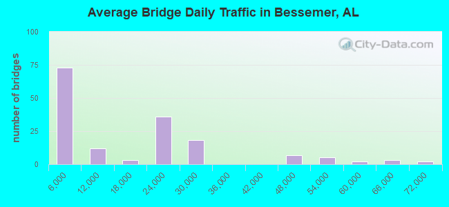
- 2,593,758Total average daily traffic
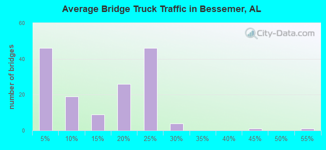
- 466,681Total average daily truck traffic
- National Bridge Inventory (NBI) Registered Bridges for Bessemer
- No street view available for this location
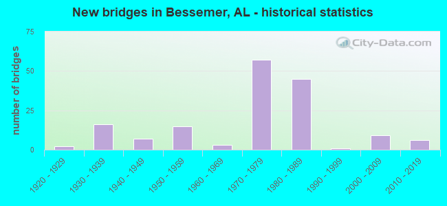
- New bridges - historical statistics
- 21920-1929
- 161930-1939
- 71940-1949
- 151950-1959
- 31960-1969
- 571970-1979
- 451980-1989
- 11990-1999
- 92000-2009
- 62010-2019
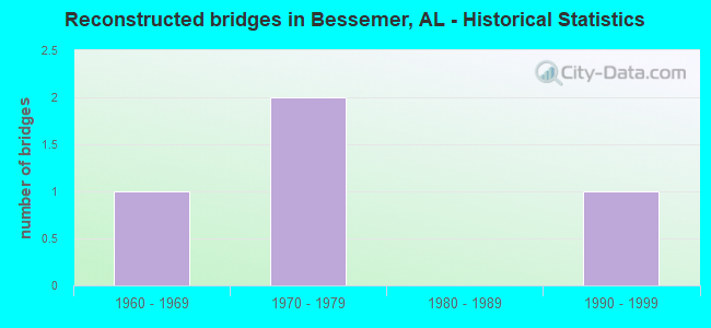
- Reconstructed bridges - Historical Statistics
- 11960-1969
- 21970-1979
- 01980-1989
- 11990-1999
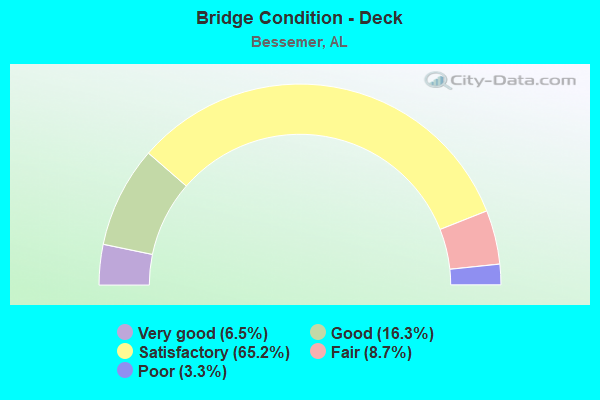
- Bridge Condition - Deck
- 6.5%Very good
- 16.3%Good
- 65.2%Satisfactory
- 8.7%Fair
- 3.3%Poor
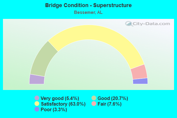
- Bridge Condition - Superstructure
- 5.4%Very good
- 20.7%Good
- 63.0%Satisfactory
- 7.6%Fair
- 3.3%Poor
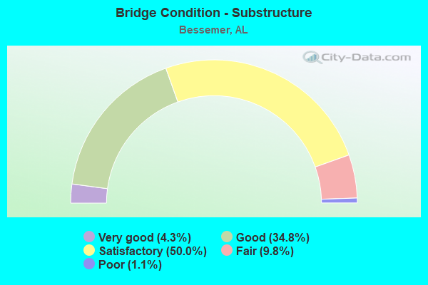
- Bridge Condition - Substructure
- 4.3%Very good
- 34.8%Good
- 50.0%Satisfactory
- 9.8%Fair
- 1.1%Poor
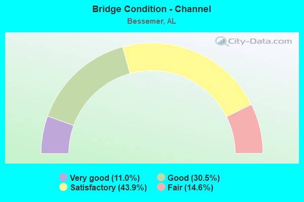
- Bridge Condition - Channel
- 11.0%Very good
- 30.5%Good
- 43.9%Satisfactory
- 14.6%Fair
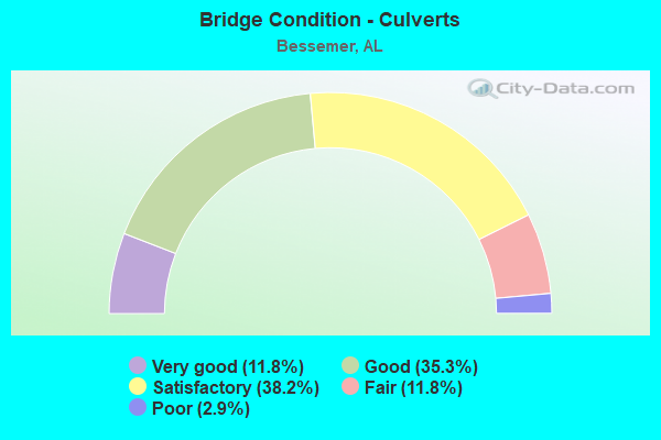
- Bridge Condition - Culverts
- 11.8%Very good
- 35.3%Good
- 38.2%Satisfactory
- 11.8%Fair
- 2.9%Poor
Find on map >> Show street view
Structure Number: 12699, Location: I 459 * CO RD 18 (Lat: 33.332939, Lng: -86.999158), Route carried "on" structure: Interstate 459, Year Built: 1982, Status: Open, Structure Length: 0.99m (3.25ft), Average Daily Traffic: 52,730 (year 2022), Truck Traffic: 20%, Average Future Daily Traffic: 66,673 (year 2042), Design Load: HS 20, Features Intersected: DRAINAGE DITCH
Minimum Vertical Clearance: 30+ m (98+ ft), Kilometerpoint: 2.868, Lanes on structure: 6, Base Highway Network: Yes, Owner: State Highway Agency, Approaching Roadway Width: 26.8m (87.9ft), Skew: 15 degrees, Material/Design: Concrete, Design/Construction: Culvert, Number Of Spans In Main Unit: 2, Length of Maximum Span: 2.4m (7.9ft)
Condition: Channel: Satisfactory, Culverts: Satisfactory, Operating Rating: 85.4 metric tons, Method Used To Determine Operating Rating: Load Factor (LF), Inventory Rating: 51.1 metric tons, Method Used To Determine Inventory Rating: Load Factor (LF), Structural Evaluation: Equal to present minimum criteria, Waterway Adequacy: Equal to present minimum criteria, Approach Roadway Alignment: Equal to present desirable criteria, Length Of Structure Improvement: 1.66m (5.45ft), Designated Inspection Frequency: Every 24 months, Inspection Date: Febuary 2022, Bridge Improvement Cost: $9,047,000, Roadway Improvement Cost: $905,000, Total Project Cost: $9,952,000 ( Estimate for 2022)
Find on map >> Show street view
Structure Number: 127, Location: CO RD 18 * I459 (Lat: 33.332569, Lng: -86.997931), Route carried "on" structure: County highway 18, Year Built: 1982, Status: Open, Structure Length: 10.97m (35.99ft), Average Daily Traffic: 5,000 (year 2002), Truck Traffic: 6%, Average Future Daily Traffic: 6,500 (year 2040), Design Load: HS 20, Features Intersected: I 459
Minimum Vertical Clearance: 30+ m (98+ ft), Kilometerpoint: 2.884, Lanes on structure: 4, Lanes under structure: 4, Owner: State Highway Agency, Approaching Roadway Width: 9.8m (32.2ft), Skew: 2 degrees, Material/Design: Steel continuous, Design/Construction: Stringer/Multi-beam, Number Of Spans In Main Unit: 4, Length of Maximum Span: 30.5m (100.1ft), Curb-To-Curb Width: 20.9m (68.6ft), Out-to-Out Width: 21.8m (71.5ft)
Condition: Deck: Satisfactory, Superstructure: Satisfactory, Substructure: Satisfactory, Operating Rating: 71.6 metric tons, Method Used To Determine Operating Rating: Load Factor (LF), Inventory Rating: 42.9 metric tons, Method Used To Determine Inventory Rating: Load Factor (LF), Structural Evaluation: Equal to present minimum criteria, Deck Geometry: Superior to present desirable criteria, Underclear: Equal to present minimum criteria, Approach Roadway Alignment: Equal to present desirable criteria, Length Of Structure Improvement: 11.86m (38.91ft), Designated Inspection Frequency: Every 24 months, Inspection Date: October 2020, Bridge Improvement Cost: $5,776,000, Roadway Improvement Cost: $578,000, Total Project Cost: $6,354,000 ( Estimate for 2022), Deck Structure Type: Concrete Cast-file-Place
Find on map >> Show street view
Structure Number: 12701, Location: POCOHANTAS RD * I459 (Lat: 33.333161, Lng: -86.982883), Route carried "on" structure: City street , Year Built: 1982, Status: Open, Structure Length: 9.80m (32.15ft), Average Daily Traffic: 1,300 (year 2020), Truck Traffic: 5%, Average Future Daily Traffic: 1,900 (year 2040), Design Load: HS 20, Features Intersected: I 459, Facility Carried by Structure: POCOHANTAS RD
Minimum Vertical Clearance: 30+ m (98+ ft), Kilometerpoint: 4.273, Lanes on structure: 2, Lanes under structure: 4, Owner: State Highway Agency, Approaching Roadway Width: 13.4m (44.0ft), Skew: 1 degrees, Material/Design: Steel continuous, Design/Construction: Stringer/Multi-beam, Number Of Spans In Main Unit: 4, Length of Maximum Span: 27.7m (90.9ft), Curb-To-Curb Width: 13.4m (44.0ft), Out-to-Out Width: 14.3m (46.9ft)
Condition: Deck: Satisfactory, Superstructure: Satisfactory, Substructure: Satisfactory, Operating Rating: 64.4 metric tons, Method Used To Determine Operating Rating: Load Factor (LF), Inventory Rating: 38.6 metric tons, Method Used To Determine Inventory Rating: Load Factor (LF), Structural Evaluation: Equal to present minimum criteria, Deck Geometry: Equal to present desirable criteria, Underclear: Equal to present minimum criteria, Approach Roadway Alignment: Equal to present minimum criteria, Length Of Structure Improvement: 10.74m (35.24ft), Designated Inspection Frequency: Every 24 months, Inspection Date: August 2020, Bridge Improvement Cost: $3,388,000, Roadway Improvement Cost: $339,000, Total Project Cost: $3,727,000 ( Estimate for 2022), Deck Structure Type: Concrete Cast-file-Place
Find on map >> Show street view
Structure Number: 12702, Location: CO RD 26 * I459 (Lat: 33.333881, Lng: -86.961272), Route carried "on" structure: County highway , Year Built: 1982, Status: Open, Structure Length: 13.55m (44.46ft), Average Daily Traffic: 1,200 (year 2021), Truck Traffic: 3%, Average Future Daily Traffic: 1,650 (year 2041), Design Load: HS 20, Features Intersected: I - 459, Facility Carried by Structure: VULCAN RD
Minimum Vertical Clearance: 30+ m (98+ ft), Kilometerpoint: 0.014, Lanes on structure: 2, Lanes under structure: 4, Owner: State Highway Agency, Approaching Roadway Width: 10.4m (34.1ft), Material/Design: Steel continuous, Design/Construction: Stringer/Multi-beam, Number Of Spans In Main Unit: 6, Length of Maximum Span: 27.4m (89.9ft), Curb-To-Curb Width: 10.4m (34.1ft), Out-to-Out Width: 11.2m (36.7ft)
Condition: Deck: Good, Superstructure: Satisfactory, Substructure: Good, Operating Rating: 62.9 metric tons, Method Used To Determine Operating Rating: Load Factor (LF), Inventory Rating: 37.6 metric tons, Method Used To Determine Inventory Rating: Load Factor (LF), Structural Evaluation: Equal to present minimum criteria, Deck Geometry: Equal to present minimum criteria, Underclear: Equal to present minimum criteria, Approach Roadway Alignment: Equal to present desirable criteria, Length Of Structure Improvement: 14.36m (47.11ft), Designated Inspection Frequency: Every 24 months, Inspection Date: January 2021, Bridge Improvement Cost: $3,545,000, Roadway Improvement Cost: $355,000, Total Project Cost: $3,900,000 ( Estimate for 2022), Deck Structure Type: Concrete Cast-file-Place
Find on map >> Show street view
Structure Number: 12703, Location: .1 MI. SO. SHADES CREEK (Lat: 33.334875, Lng: -86.952114), Route carried "on" structure: Interstate 459, Year Built: 1982, Status: Open, Structure Length: 3.11m (10.20ft), Average Daily Traffic: 26,365 (year 2020), Truck Traffic: 20%, Average Future Daily Traffic: 33,336 (year 2040), Design Load: HS 20, Features Intersected: RELIEF
Minimum Vertical Clearance: 30+ m (98+ ft), Kilometerpoint: 7.237, Lanes on structure: 2, Base Highway Network: Yes, Owner: State Highway Agency, Approaching Roadway Width: 13.4m (44.0ft), Material/Design: Prestressed concrete continuous, Design/Construction: Stringer/Multi-beam, Number Of Spans In Main Unit: 3, Length of Maximum Span: 10.4m (34.1ft), Curb-To-Curb Width: 12.2m (40.0ft), Out-to-Out Width: 13.0m (42.7ft)
Condition: Deck: Good, Superstructure: Good, Substructure: Good, Channel: Satisfactory, Operating Rating: 63.8 metric tons, Method Used To Determine Operating Rating: Load Factor (LF), Inventory Rating: 38.2 metric tons, Method Used To Determine Inventory Rating: Load Factor (LF), Structural Evaluation: Better than present minimum criteria, Deck Geometry: Better than present minimum criteria, Waterway Adequacy: Better than present minimum criteria, Approach Roadway Alignment: Equal to present desirable criteria, Length Of Structure Improvement: 3.96m (12.99ft), Designated Inspection Frequency: Every 24 months, Inspection Date: April 2020, Bridge Improvement Cost: $1,141,000, Roadway Improvement Cost: $114,000, Total Project Cost: $1,255,000 ( Estimate for 2022), Deck Structure Type: Concrete Cast-file-Place
Find on map >> Show street view
Structure Number: 12704, Location: .1 MI SO. SHADES CREEK (Lat: 33.334628, Lng: -86.952083), Route carried "on" structure: Interstate 459, Year Built: 1982, Status: Open, Structure Length: 3.11m (10.20ft), Average Daily Traffic: 26,365 (year 2020), Truck Traffic: 20%, Average Future Daily Traffic: 33,336 (year 2040), Design Load: HS 20, Features Intersected: RELIEF DITCH
Minimum Vertical Clearance: 30+ m (98+ ft), Kilometerpoint: 7.237, Lanes on structure: 2, Base Highway Network: Yes, Owner: State Highway Agency, Approaching Roadway Width: 13.4m (44.0ft), Material/Design: Prestressed concrete continuous, Design/Construction: Stringer/Multi-beam, Number Of Spans In Main Unit: 3, Length of Maximum Span: 10.4m (34.1ft), Curb-To-Curb Width: 12.2m (40.0ft), Out-to-Out Width: 13.0m (42.7ft)
Condition: Deck: Good, Superstructure: Good, Substructure: Good, Channel: Satisfactory, Operating Rating: 73.4 metric tons, Method Used To Determine Operating Rating: Load Factor (LF), Inventory Rating: 43.5 metric tons, Method Used To Determine Inventory Rating: Load Factor (LF), Structural Evaluation: Better than present minimum criteria, Deck Geometry: Better than present minimum criteria, Waterway Adequacy: Better than present minimum criteria, Approach Roadway Alignment: Equal to present desirable criteria, Length Of Structure Improvement: 3.96m (12.99ft), Designated Inspection Frequency: Every 24 months, Inspection Date: April 2020, Bridge Improvement Cost: $1,141,000, Roadway Improvement Cost: $114,000, Total Project Cost: $1,255,000 ( Estimate for 2022), Deck Structure Type: Concrete Cast-file-Place, Wearing Surface/Protective System: Wearing Surface: Epoxy Overlay
Find on map >> Show street view
Structure Number: 12705, Location: I459 * SHADES CK (Lat: 33.335283, Lng: -86.947919), Route carried "on" structure: Interstate 459, Year Built: 1982, Status: Open, Structure Length: 13.17m (43.21ft), Average Daily Traffic: 26,365 (year 2020), Truck Traffic: 20%, Average Future Daily Traffic: 33,336 (year 2040), Design Load: HS 20, Features Intersected: SHADES CK
Minimum Vertical Clearance: 7.56m (24.80ft), Kilometerpoint: 7.575, Lanes on structure: 2, Base Highway Network: Yes, Owner: State Highway Agency, Approaching Roadway Width: 13.4m (44.0ft), Material/Design: Steel continuous, Design/Construction: Stringer/Multi-beam, Number Of Spans In Main Unit: 3, Number Of Approach Spans: 5, Length of Maximum Span: 30.5m (100.1ft), Curb-To-Curb Width: 12.2m (40.0ft), Out-to-Out Width: 13.0m (42.7ft)
Condition: Deck: Satisfactory, Superstructure: Satisfactory, Substructure: Satisfactory, Channel: Satisfactory, Operating Rating: 56.6 metric tons, Method Used To Determine Operating Rating: Load Factor (LF), Inventory Rating: 33.8 metric tons, Method Used To Determine Inventory Rating: Load Factor (LF), Structural Evaluation: Equal to present minimum criteria, Deck Geometry: Better than present minimum criteria, Waterway Adequacy: Equal to present desirable criteria, Approach Roadway Alignment: Equal to present desirable criteria, Length Of Structure Improvement: 13.99m (45.90ft), Designated Inspection Frequency: Every 24 months, Inspection Date: June 2020, Bridge Improvement Cost: $4,029,000, Roadway Improvement Cost: $403,000, Total Project Cost: $4,432,000 ( Estimate for 2022), Deck Structure Type: Concrete Cast-file-Place
Find on map >> Show street view
Structure Number: 12706, Location: I459 * SHADES CK (Lat: 33.335031, Lng: -86.947906), Route carried "on" structure: Interstate 459, Year Built: 1982, Status: Open, Structure Length: 13.17m (43.21ft), Average Daily Traffic: 26,365 (year 2020), Truck Traffic: 20%, Average Future Daily Traffic: 33,336 (year 2040), Design Load: HS 20, Features Intersected: SHADES CK
Minimum Vertical Clearance: 30+ m (98+ ft), Kilometerpoint: 7.575, Lanes on structure: 2, Base Highway Network: Yes, Owner: State Highway Agency, Approaching Roadway Width: 13.4m (44.0ft), Material/Design: Steel continuous, Design/Construction: Stringer/Multi-beam, Number Of Spans In Main Unit: 3, Number Of Approach Spans: 5, Length of Maximum Span: 30.5m (100.1ft), Curb-To-Curb Width: 12.2m (40.0ft), Out-to-Out Width: 13.0m (42.7ft)
Condition: Deck: Satisfactory, Superstructure: Satisfactory, Substructure: Good, Channel: Satisfactory, Operating Rating: 64.2 metric tons, Method Used To Determine Operating Rating: Load Factor (LF), Inventory Rating: 38.9 metric tons, Method Used To Determine Inventory Rating: Load Factor (LF), Structural Evaluation: Equal to present minimum criteria, Deck Geometry: Better than present minimum criteria, Waterway Adequacy: Better than present minimum criteria, Approach Roadway Alignment: Equal to present desirable criteria, Length Of Structure Improvement: 13.99m (45.90ft), Designated Inspection Frequency: Every 24 months, Inspection Date: June 2020, Bridge Improvement Cost: $4,029,000, Roadway Improvement Cost: $403,000, Total Project Cost: $4,432,000 ( Estimate for 2022), Deck Structure Type: Concrete Cast-file-Place
Find on map >> Show street view
Structure Number: 12707, Location: .4 MI. NO. SHADES CREEK (Lat: 33.336033, Lng: -86.940289), Route carried "on" structure: Interstate 459, Year Built: 1982, Status: Open, Structure Length: 9.33m (30.61ft), Average Daily Traffic: 26,365 (year 2020), Truck Traffic: 20%, Average Future Daily Traffic: 33,336 (year 2040), Design Load: HS 20, Features Intersected: SHADES CK RELIEF
Minimum Vertical Clearance: 30+ m (98+ ft), Kilometerpoint: 8.216, Lanes on structure: 2, Base Highway Network: Yes, Owner: State Highway Agency, Approaching Roadway Width: 13.4m (44.0ft), Material/Design: Prestressed concrete continuous, Design/Construction: Stringer/Multi-beam, Number Of Spans In Main Unit: 9, Length of Maximum Span: 10.4m (34.1ft), Curb-To-Curb Width: 12.2m (40.0ft), Out-to-Out Width: 13.0m (42.7ft)
Condition: Deck: Satisfactory, Superstructure: Satisfactory, Substructure: Good, Channel: Very good, Operating Rating: 63.8 metric tons, Method Used To Determine Operating Rating: Load Factor (LF), Inventory Rating: 38.2 metric tons, Method Used To Determine Inventory Rating: Load Factor (LF), Structural Evaluation: Equal to present minimum criteria, Deck Geometry: Better than present minimum criteria, Waterway Adequacy: Equal to present desirable criteria, Approach Roadway Alignment: Equal to present desirable criteria, Length Of Structure Improvement: 10.29m (33.76ft), Designated Inspection Frequency: Every 24 months, Inspection Date: May 2020, Bridge Improvement Cost: $2,963,000, Roadway Improvement Cost: $296,000, Total Project Cost: $3,259,000 ( Estimate for 2022), Deck Structure Type: Concrete Cast-file-Place
Find on map >> Show street view
Structure Number: 12708, Location: .4 MI. NO. SHADES CREEK (Lat: 33.335781, Lng: -86.940247), Route carried "on" structure: Interstate 459, Year Built: 1982, Status: Open, Structure Length: 9.33m (30.61ft), Average Daily Traffic: 26,365 (year 2020), Truck Traffic: 20%, Average Future Daily Traffic: 33,336 (year 2040), Design Load: HS 20, Features Intersected: SHADES CK RELIEF
Minimum Vertical Clearance: 30+ m (98+ ft), Kilometerpoint: 8.216, Lanes on structure: 2, Base Highway Network: Yes, Owner: State Highway Agency, Approaching Roadway Width: 13.4m (44.0ft), Material/Design: Prestressed concrete continuous, Design/Construction: Stringer/Multi-beam, Number Of Spans In Main Unit: 9, Length of Maximum Span: 10.4m (34.1ft), Curb-To-Curb Width: 12.2m (40.0ft), Out-to-Out Width: 13.0m (42.7ft)
Condition: Deck: Satisfactory, Superstructure: Satisfactory, Substructure: Good, Channel: Very good, Operating Rating: 75.1 metric tons, Method Used To Determine Operating Rating: Load Factor (LF), Inventory Rating: 45.3 metric tons, Method Used To Determine Inventory Rating: Load Factor (LF), Structural Evaluation: Equal to present minimum criteria, Deck Geometry: Better than present minimum criteria, Waterway Adequacy: Equal to present desirable criteria, Approach Roadway Alignment: Equal to present desirable criteria, Length Of Structure Improvement: 10.29m (33.76ft), Designated Inspection Frequency: Every 24 months, Inspection Date: May 2020, Bridge Improvement Cost: $2,963,000, Roadway Improvement Cost: $296,000, Total Project Cost: $3,259,000 ( Estimate for 2022), Deck Structure Type: Concrete Cast-file-Place
Find on map >> Show street view
Structure Number: 12709, Location: .5 MI. NO. SHADES CREEK (Lat: 33.336264, Lng: -86.937853), Route carried "on" structure: Interstate 459, Year Built: 1982, Status: Open, Structure Length: 5.18m (16.99ft), Average Daily Traffic: 26,365 (year 2020), Truck Traffic: 20%, Average Future Daily Traffic: 33,336 (year 2040), Design Load: HS 20, Features Intersected: SHADES CK RELIEF 2
Minimum Vertical Clearance: 30+ m (98+ ft), Kilometerpoint: 8.441, Lanes on structure: 2, Base Highway Network: Yes, Owner: State Highway Agency, Approaching Roadway Width: 13.4m (44.0ft), Material/Design: Prestressed concrete continuous, Design/Construction: Stringer/Multi-beam, Number Of Spans In Main Unit: 5, Length of Maximum Span: 10.4m (34.1ft), Curb-To-Curb Width: 12.2m (40.0ft), Out-to-Out Width: 13.0m (42.7ft)
Condition: Deck: Satisfactory, Superstructure: Good, Substructure: Good, Channel: Very good, Operating Rating: 75.1 metric tons, Method Used To Determine Operating Rating: Load Factor (LF), Inventory Rating: 45.3 metric tons, Method Used To Determine Inventory Rating: Load Factor (LF), Structural Evaluation: Better than present minimum criteria, Deck Geometry: Better than present minimum criteria, Waterway Adequacy: Equal to present desirable criteria, Approach Roadway Alignment: Equal to present desirable criteria, Length Of Structure Improvement: 6.20m (20.34ft), Designated Inspection Frequency: Every 24 months, Inspection Date: May 2020, Bridge Improvement Cost: $1,786,000, Roadway Improvement Cost: $179,000, Total Project Cost: $1,965,000 ( Estimate for 2022), Deck Structure Type: Concrete Cast-file-Place
Find on map >> Show street view
Structure Number: 1271, Location: .5 MI. NO. SHADES CREEK (Lat: 33.336022, Lng: -86.937814), Route carried "on" structure: Interstate 459, Year Built: 1982, Status: Open, Structure Length: 5.18m (16.99ft), Average Daily Traffic: 26,365 (year 2020), Truck Traffic: 20%, Average Future Daily Traffic: 33,336 (year 2040), Design Load: HS 20, Features Intersected: SHADES CK RELIEF 2
Minimum Vertical Clearance: 30+ m (98+ ft), Kilometerpoint: 8.441, Lanes on structure: 2, Base Highway Network: Yes, Owner: State Highway Agency, Approaching Roadway Width: 13.4m (44.0ft), Material/Design: Prestressed concrete continuous, Design/Construction: Stringer/Multi-beam, Number Of Spans In Main Unit: 5, Length of Maximum Span: 10.4m (34.1ft), Curb-To-Curb Width: 12.2m (40.0ft), Out-to-Out Width: 13.0m (42.7ft)
Condition: Deck: Satisfactory, Superstructure: Good, Substructure: Good, Channel: Very good, Operating Rating: 75.1 metric tons, Method Used To Determine Operating Rating: Load Factor (LF), Inventory Rating: 45.3 metric tons, Method Used To Determine Inventory Rating: Load Factor (LF), Structural Evaluation: Better than present minimum criteria, Deck Geometry: Better than present minimum criteria, Waterway Adequacy: Equal to present desirable criteria, Approach Roadway Alignment: Equal to present desirable criteria, Length Of Structure Improvement: 6.20m (20.34ft), Designated Inspection Frequency: Every 24 months, Inspection Date: May 2020, Bridge Improvement Cost: $1,786,000, Roadway Improvement Cost: $179,000, Total Project Cost: $1,965,000 ( Estimate for 2022), Deck Structure Type: Concrete Cast-file-Place
Find on map >> Show street view
Structure Number: 12711, Location: I 459 * SOU RR (Lat: 33.337447, Lng: -86.925569), Route carried "on" structure: Interstate 459, Year Built: 1982, Status: Open, Structure Length: 14.05m (46.10ft), Average Daily Traffic: 69,067 (year 2021), Truck Traffic: 20%, Average Future Daily Traffic: 124,741 (year 2041), Design Load: HS 20, Features Intersected: SOU RR
Minimum Vertical Clearance: 30+ m (98+ ft), Kilometerpoint: 9.843, Lanes on structure: 3, Base Highway Network: Yes, Owner: State Highway Agency, Approaching Roadway Width: 13.4m (44.0ft), Skew: 5 degrees, Material/Design: Steel continuous, Design/Construction: Stringer/Multi-beam, Number Of Spans In Main Unit: 4, Number Of Approach Spans: 1, Length of Maximum Span: 36.6m (120.1ft), Curb-To-Curb Width: 12.2m (40.0ft), Out-to-Out Width: 13.0m (42.7ft)
Condition: Deck: Satisfactory, Superstructure: Satisfactory, Substructure: Good, Operating Rating: 65.7 metric tons, Method Used To Determine Operating Rating: Load Factor (LF), Inventory Rating: 39.3 metric tons, Method Used To Determine Inventory Rating: Load Factor (LF), Structural Evaluation: Equal to present minimum criteria, Deck Geometry: High priority of corrective action, Underclear: Superior to present desirable criteria, Approach Roadway Alignment: Equal to present desirable criteria, Length Of Structure Improvement: 14.85m (48.72ft), Designated Inspection Frequency: Every 24 months, Inspection Date: January 2021, Bridge Improvement Cost: $4,276,000, Roadway Improvement Cost: $428,000, Total Project Cost: $4,704,000 ( Estimate for 2022), Deck Structure Type: Concrete Cast-file-Place
Find on map >> Show street view
Structure Number: 12712, Location: I459 * CO RD 52(MORGAN RD (Lat: 33.339122, Lng: -86.920547), Route carried "on" structure: Interstate 459, Year Built: 1982, Status: Open, Structure Length: 8.72m (28.61ft), Average Daily Traffic: 27,200 (year 2020), Truck Traffic: 20%, Average Future Daily Traffic: 34,392 (year 2040), Design Load: HS 20, Features Intersected: CO RD 52
Minimum Vertical Clearance: 7.56m (24.80ft), Kilometerpoint: 10.421, Lanes on structure: 2, Lanes under structure: 4, Base Highway Network: Yes, Owner: State Highway Agency, Approaching Roadway Width: 12.2m (40.0ft), Skew: 3 degrees, Material/Design: Steel continuous, Design/Construction: Stringer/Multi-beam, Number Of Spans In Main Unit: 3, Length of Maximum Span: 34.1m (111.9ft), Curb-To-Curb Width: 12.2m (40.0ft), Out-to-Out Width: 13.1m (43.0ft)
Condition: Deck: Satisfactory, Superstructure: Satisfactory, Substructure: Good, Operating Rating: 65.3 metric tons, Method Used To Determine Operating Rating: Load Factor (LF), Inventory Rating: 39.1 metric tons, Method Used To Determine Inventory Rating: Load Factor (LF), Structural Evaluation: Equal to present minimum criteria, Deck Geometry: Better than present minimum criteria, Underclear: Superior to present desirable criteria, Approach Roadway Alignment: Equal to present desirable criteria, Length Of Structure Improvement: 9.70m (31.82ft), Designated Inspection Frequency: Every 24 months, Inspection Date: August 2020, Bridge Improvement Cost: $2,860,000, Roadway Improvement Cost: $286,000, Total Project Cost: $3,146,000 ( Estimate for 2022), Deck Structure Type: Concrete Cast-file-Place
Find on map >> Show street view
Structure Number: 12713, Location: I459 * CO RD 52(MORGAN RD (Lat: 33.338928, Lng: -86.920319), Route carried "on" structure: Interstate 459, Year Built: 1982, Status: Open, Structure Length: 8.72m (28.61ft), Average Daily Traffic: 27,200 (year 2020), Truck Traffic: 20%, Average Future Daily Traffic: 34,392 (year 2040), Design Load: HS 20, Features Intersected: CO RD 52
Minimum Vertical Clearance: 7.56m (24.80ft), Kilometerpoint: 10.421, Lanes on structure: 2, Lanes under structure: 4, Base Highway Network: Yes, Owner: State Highway Agency, Approaching Roadway Width: 12.2m (40.0ft), Skew: 3 degrees, Material/Design: Steel continuous, Design/Construction: Stringer/Multi-beam, Number Of Spans In Main Unit: 3, Length of Maximum Span: 34.1m (111.9ft), Curb-To-Curb Width: 12.2m (40.0ft), Out-to-Out Width: 13.1m (43.0ft)
Condition: Deck: Satisfactory, Superstructure: Satisfactory, Substructure: Good, Operating Rating: 65.3 metric tons, Method Used To Determine Operating Rating: Load Factor (LF), Inventory Rating: 39.1 metric tons, Method Used To Determine Inventory Rating: Load Factor (LF), Structural Evaluation: Equal to present minimum criteria, Deck Geometry: Better than present minimum criteria, Underclear: Superior to present desirable criteria, Approach Roadway Alignment: Equal to present desirable criteria, Length Of Structure Improvement: 9.70m (31.82ft), Designated Inspection Frequency: Every 24 months, Inspection Date: August 2020, Bridge Improvement Cost: $2,860,000, Roadway Improvement Cost: $286,000, Total Project Cost: $3,146,000 ( Estimate for 2022), Deck Structure Type: Concrete Cast-file-Place
Find on map >> Show street view
Structure Number: 1285, Location: 4.2 MI S JOHNS ROAD (Lat: 33.338792, Lng: -87.087886), Route carried "on" structure: County highway 453, Year Built: 1982, Status: Open, Structure Length: 0.73m (2.40ft), Average Daily Traffic: 253 (year 2018), Truck Traffic: 1%, Average Future Daily Traffic: 350 (year 2038), Design Load: HS 20, Features Intersected: BLUE CREEK, Facility Carried by Structure: BLUE CREEK ROAD
Minimum Vertical Clearance: 30+ m (98+ ft), Kilometerpoint: 0.010, Lanes on structure: 2, Owner: County Highway Agency, Approaching Roadway Width: 6.7m (22.0ft), Skew: 3 degrees, Material/Design: Concrete, Design/Construction: Culvert, Number Of Spans In Main Unit: 2, Length of Maximum Span: 3.7m (12.1ft)
Condition: Channel: Good, Culverts: Satisfactory, Operating Rating: 43.5 metric tons, Method Used To Determine Operating Rating: Load Factor (LF), Inventory Rating: 32.7 metric tons, Method Used To Determine Inventory Rating: Load Factor (LF), Structural Evaluation: Equal to present minimum criteria, Waterway Adequacy: Better than present minimum criteria, Approach Roadway Alignment: Better than present minimum criteria, Length Of Structure Improvement: 1.38m (4.53ft), Designated Inspection Frequency: Every 24 months, Inspection Date: November 2020, Bridge Improvement Cost: $1,184,000, Roadway Improvement Cost: $118,000, Total Project Cost: $1,302,000 ( Estimate for 2022)
Find on map >> Show street view
Structure Number: 12908, Location: GREENWOOD DR * I459 (Lat: 33.336822, Lng: -86.930867), Route carried "on" structure: Alternate County highway , Year Built: 1983, Status: Open, Structure Length: 15.12m (49.61ft), Average Daily Traffic: 950 (year 2021), Truck Traffic: 1%, Average Future Daily Traffic: 1,500 (year 2041), Design Load: HS 20, Features Intersected: I - 459, Facility Carried by Structure: GREENWOOD DR
Minimum Vertical Clearance: 30+ m (98+ ft), Kilometerpoint: 0.010, Lanes on structure: 2, Lanes under structure: 4, Owner: State Highway Agency, Approaching Roadway Width: 13.4m (44.0ft), Skew: 3 degrees, Material/Design: Steel continuous, Design/Construction: Stringer/Multi-beam, Number Of Spans In Main Unit: 4, Number Of Approach Spans: 2, Length of Maximum Span: 35.1m (115.2ft), Curb-To-Curb Width: 12.2m (40.0ft), Out-to-Out Width: 13.0m (42.7ft)
Condition: Deck: Satisfactory, Superstructure: Satisfactory, Substructure: Good, Operating Rating: 40.8 metric tons, Method Used To Determine Operating Rating: Load Factor (LF), Inventory Rating: 24.5 metric tons, Method Used To Determine Inventory Rating: Load Factor (LF), Structural Evaluation: Equal to present minimum criteria, Deck Geometry: Equal to present desirable criteria, Underclear: High priority of corrective action, Approach Roadway Alignment: Equal to present minimum criteria, Length Of Structure Improvement: 15.89m (52.13ft), Designated Inspection Frequency: Every 24 months, Inspection Date: January 2021, Bridge Improvement Cost: $4,577,000, Roadway Improvement Cost: $458,000, Total Project Cost: $5,035,000 ( Estimate for 2022), Deck Structure Type: Concrete Cast-file-Place
Find on map >> Show street view
Structure Number: 12909, Location: I459 SOUTH * SOU RR (Lat: 33.337583, Lng: -86.926103), Route carried "on" structure: Interstate 459, Year Built: 1983, Status: Open, Structure Length: 14.06m (46.13ft), Average Daily Traffic: 69,067 (year 2021), Truck Traffic: 20%, Average Future Daily Traffic: 124,741 (year 2041), Design Load: HS 20, Features Intersected: SOUTHERN RR
Minimum Vertical Clearance: 30+ m (98+ ft), Kilometerpoint: 9.843, Lanes on structure: 3, Base Highway Network: Yes, Owner: State Highway Agency, Approaching Roadway Width: 15.8m (51.8ft), Skew: 3 degrees, Material/Design: Steel continuous, Design/Construction: Stringer/Multi-beam, Number Of Spans In Main Unit: 3, Number Of Approach Spans: 2, Length of Maximum Span: 39.6m (129.9ft), Curb-To-Curb Width: 15.8m (51.8ft), Out-to-Out Width: 16.3m (53.5ft)
Condition: Deck: Satisfactory, Superstructure: Satisfactory, Substructure: Satisfactory, Operating Rating: 41.6 metric tons, Method Used To Determine Operating Rating: Load Factor (LF), Inventory Rating: 24.9 metric tons, Method Used To Determine Inventory Rating: Load Factor (LF), Structural Evaluation: Equal to present minimum criteria, Deck Geometry: Somewhat better than minimum adequacy, Underclear: Superior to present desirable criteria, Approach Roadway Alignment: Equal to present desirable criteria, Length Of Structure Improvement: 14.85m (48.72ft), Designated Inspection Frequency: Every 24 months, Inspection Date: January 2021, Bridge Improvement Cost: $5,398,000, Roadway Improvement Cost: $540,000, Total Project Cost: $5,938,000 ( Estimate for 2022), Deck Structure Type: Concrete Cast-file-Place
Find on map >> Show street view
Structure Number: 1291, Location: 0.1 MILE NO SOU RR (Lat: 33.338011, Lng: -86.923839), Route carried "on" structure: Interstate 459, Year Built: 1983, Status: Open, Structure Length: 1.43m (4.69ft), Average Daily Traffic: 54,400 (year 2020), Truck Traffic: 20%, Average Future Daily Traffic: 68,785 (year 2040), Design Load: HS 20, Features Intersected: STREAM
Minimum Vertical Clearance: 30+ m (98+ ft), Kilometerpoint: 10.083, Lanes on structure: 6, Base Highway Network: Yes, Owner: State Highway Agency, Approaching Roadway Width: 26.8m (87.9ft), Skew: 14 degrees, Material/Design: Concrete, Design/Construction: Culvert, Number Of Spans In Main Unit: 3, Length of Maximum Span: 3.0m (9.8ft)
Condition: Channel: Good, Culverts: Good, Operating Rating: 88.9 metric tons, Method Used To Determine Operating Rating: Load Factor (LF), Inventory Rating: 88.9 metric tons, Method Used To Determine Inventory Rating: Load Factor (LF), Structural Evaluation: Better than present minimum criteria, Waterway Adequacy: Equal to present desirable criteria, Approach Roadway Alignment: Equal to present desirable criteria, Length Of Structure Improvement: 2.11m (6.92ft), Designated Inspection Frequency: Every 24 months, Inspection Date: June 2020, Bridge Improvement Cost: $6,868,000, Roadway Improvement Cost: $687,000, Total Project Cost: $7,555,000 ( Estimate for 2022), Deck Structure Type: Concrete Cast-file-Place
Find on map >> Show street view
Structure Number: 12911, Location: I459 * PARKWOOD RD (Lat: 33.341567, Lng: -86.902467), Route carried "on" structure: County highway , Year Built: 1983, Status: Open, Structure Length: 10.36m (33.99ft), Average Daily Traffic: 5,500 (year 1998), Truck Traffic: 1%, Average Future Daily Traffic: 6,800 (year 2040), Design Load: HS 20, Features Intersected: I 459, Facility Carried by Structure: PARKWOOD RD
Minimum Vertical Clearance: 30+ m (98+ ft), Kilometerpoint: 0.014, Lanes on structure: 2, Lanes under structure: 6, Owner: State Highway Agency, Approaching Roadway Width: 11.0m (36.1ft), Skew: 9 degrees, Material/Design: Steel continuous, Design/Construction: Stringer/Multi-beam, Number Of Spans In Main Unit: 4, Length of Maximum Span: 28.3m (92.8ft), Curb-To-Curb Width: 10.4m (34.1ft), Out-to-Out Width: 11.2m (36.7ft)
Condition: Deck: Satisfactory, Superstructure: Satisfactory, Substructure: Good, Operating Rating: 59.3 metric tons, Method Used To Determine Operating Rating: Load Factor (LF), Inventory Rating: 34.6 metric tons, Method Used To Determine Inventory Rating: Load Factor (LF), Structural Evaluation: Equal to present minimum criteria, Deck Geometry: Meets minimum limits, Underclear: Equal to present minimum criteria, Approach Roadway Alignment: Equal to present minimum criteria, Length Of Structure Improvement: 11.28m (37.01ft), Designated Inspection Frequency: Every 24 months, Inspection Date: October 2020, Bridge Improvement Cost: $2,783,000, Roadway Improvement Cost: $278,000, Total Project Cost: $3,061,000 ( Estimate for 2022), Deck Structure Type: Concrete Cast-file-Place
Find on map >> Show street view
Structure Number: 12918, Location: ROCK MT LAKE EXIT (Lat: 33.324192, Lng: -87.048136), Route carried "on" structure: County highway , Year Built: 1983, Status: Open, Structure Length: 8.78m (28.81ft), Average Daily Traffic: 2,000 (year 2021), Truck Traffic: 50%, Average Future Daily Traffic: 3,000 (year 2041), Design Load: HS 20, Features Intersected: I - 20/59, Facility Carried by Structure: McASHAN DRIVE
Minimum Vertical Clearance: 30+ m (98+ ft), Kilometerpoint: 1.609, Lanes on structure: 2, Lanes under structure: 6, Owner: State Highway Agency, Approaching Roadway Width: 7.3m (24.0ft), Material/Design: Prestressed concrete, Design/Construction: Stringer/Multi-beam, Number Of Spans In Main Unit: 4, Length of Maximum Span: 21.3m (69.9ft), Curb-To-Curb Width: 12.2m (40.0ft), Out-to-Out Width: 13.0m (42.7ft)
Condition: Deck: Good, Superstructure: Satisfactory, Substructure: Satisfactory, Operating Rating: 77.7 metric tons, Method Used To Determine Operating Rating: Load Factor (LF), Inventory Rating: 36.3 metric tons, Method Used To Determine Inventory Rating: Load Factor (LF), Structural Evaluation: Equal to present minimum criteria, Deck Geometry: Better than present minimum criteria, Underclear: Equal to present minimum criteria, Approach Roadway Alignment: Equal to present desirable criteria, Length Of Structure Improvement: 9.76m (32.02ft), Designated Inspection Frequency: Every 24 months, Inspection Date: July 2021, Bridge Improvement Cost: $2,811,000, Roadway Improvement Cost: $281,000, Total Project Cost: $3,092,000 ( Estimate for 2022), Deck Structure Type: Concrete Cast-file-Place
Find on map >> Show street view
Structure Number: 13072, Location: AT JCT I-20/59 * I-459 (Lat: 33.344283, Lng: -87.022933), Route carried "on" structure: County highway 449, Year Built: 1983, Status: Open, Structure Length: 0.79m (2.59ft), Average Daily Traffic: 44 (year 2021), Average Future Daily Traffic: 63 (year 2041), Design Load: HS 20, Features Intersected: UNNAMED CREEK, Facility Carried by Structure: FLINT HILL RD
Minimum Vertical Clearance: 30+ m (98+ ft), Kilometerpoint: 0.010, Lanes on structure: 2, Owner: County Highway Agency, Approaching Roadway Width: 6.1m (20.0ft), Skew: 3 degrees, Material/Design: Concrete, Design/Construction: Culvert, Number Of Spans In Main Unit: 2, Length of Maximum Span: 3.6m (11.8ft), Curb or Sidewalk Widths: Left: 0.2m (0.7ft), Right: 0.3m (1.0ft), Curb-To-Curb Width: 12.4m (40.7ft), Out-to-Out Width: 12.9m (42.3ft)
Condition: Channel: Satisfactory, Culverts: Good, Operating Rating: 49.6 metric tons, Method Used To Determine Operating Rating: Load Factor (LF), Inventory Rating: 29.8 metric tons, Method Used To Determine Inventory Rating: Load Factor (LF), Structural Evaluation: Better than present minimum criteria, Deck Geometry: Superior to present desirable criteria, Waterway Adequacy: Equal to present minimum criteria, Approach Roadway Alignment: Better than present minimum criteria, Length Of Structure Improvement: 1.44m (4.72ft), Designated Inspection Frequency: Every 24 months, Inspection Date: November 2021, Bridge Improvement Cost: $408,000, Roadway Improvement Cost: $41,000, Total Project Cost: $449,000 ( Estimate for 2022)
Find on map >> Show street view
Structure Number: 13548, Location: 50' W JCT SEALES RD (Lat: 33.318133, Lng: -86.906300), Route carried "on" structure: County highway , Year Built: 1985, Status: Open, Structure Length: 1.28m (4.20ft), Average Daily Traffic: 328 (year 2020), Truck Traffic: 1%, Average Future Daily Traffic: 450 (year 2040), Design Load: HS 20, Features Intersected: RICE CREEK, Facility Carried by Structure: PORTER GREEN ROAD
Minimum Vertical Clearance: 30+ m (98+ ft), Kilometerpoint: 0.010, Lanes on structure: 2, Owner: County Highway Agency, Approaching Roadway Width: 6.8m (22.3ft), Skew: 1 degrees, Material/Design: Prestressed concrete, Design/Construction: Box Beam or Girders - Multiple, Number Of Spans In Main Unit: 1, Length of Maximum Span: 12.3m (40.4ft), Curb or Sidewalk Widths: Left: 0.3m (1.0ft), Right: 0.3m (1.0ft), Curb-To-Curb Width: 8.9m (29.2ft), Out-to-Out Width: 9.8m (32.2ft)
Condition: Deck: Very good, Superstructure: Very good, Substructure: Good, Channel: Satisfactory, Operating Rating: 63.0 metric tons, Method Used To Determine Operating Rating: Load Factor (LF), Inventory Rating: 37.7 metric tons, Method Used To Determine Inventory Rating: Load Factor (LF), Structural Evaluation: Better than present minimum criteria, Deck Geometry: Equal to present minimum criteria, Waterway Adequacy: Equal to present minimum criteria, Approach Roadway Alignment: Equal to present minimum criteria, Length Of Structure Improvement: 1.95m (6.40ft), Designated Inspection Frequency: Every 24 months, Inspection Date: June 2020, Bridge Improvement Cost: $429,000, Roadway Improvement Cost: $43,000, Total Project Cost: $472,000 ( Estimate for 2022), Deck Structure Type: Concrete Precast Panels, Wearing Surface/Protective System: Wearing Surface: Bituminous
Find on map >> Show street view
Structure Number: 13549, Location: .5 MI S SHADES CREEK (Lat: 33.351400, Lng: -86.935567), Route carried "on" structure: County highway , Year Built: 1985, Status: Open, Structure Length: 2.07m (6.79ft), Average Daily Traffic: 9,515 (year 2020), Truck Traffic: 5%, Average Future Daily Traffic: 13,300 (year 2040), Design Load: HS 20, Features Intersected: SHADES CREEK RELIEF, Facility Carried by Structure: MORGAN ROAD
Minimum Vertical Clearance: 30+ m (98+ ft), Kilometerpoint: 0.000, Lanes on structure: 2, Owner: County Highway Agency, Approaching Roadway Width: 7.9m (25.9ft), Material/Design: Concrete, Design/Construction: Channel Beam, Number Of Spans In Main Unit: 2, Length of Maximum Span: 9.6m (31.5ft), Curb-To-Curb Width: 8.6m (28.2ft), Out-to-Out Width: 9.4m (30.8ft)
Condition: Deck: Good, Superstructure: Satisfactory, Substructure: Satisfactory, Channel: Satisfactory, Operating Rating: 66.2 metric tons, Method Used To Determine Operating Rating: Load Factor (LF), Inventory Rating: 39.7 metric tons, Method Used To Determine Inventory Rating: Load Factor (LF), Structural Evaluation: Equal to present minimum criteria, Deck Geometry: High priority of replacement, Waterway Adequacy: Equal to present minimum criteria, Approach Roadway Alignment: Better than present minimum criteria, Length Of Structure Improvement: 2.84m (9.32ft), Designated Inspection Frequency: Every 24 months, Inspection Date: October 2020, Bridge Improvement Cost: $584,000, Roadway Improvement Cost: $58,000, Total Project Cost: $642,000 ( Estimate for 2022), Deck Structure Type: Concrete Precast Panels, Wearing Surface/Protective System: Wearing Surface: Bituminous
Find on map >> Show street view
Structure Number: 1402, Location: 1.6 MI S SR20 (Lat: 34.655581, Lng: -86.755889), Route carried "on" structure: City street , Year Built: 1986, Status: Open, Structure Length: 3.11m (10.20ft), Average Daily Traffic: 22,000 (year 2017), Truck Traffic: 3%, Average Future Daily Traffic: 30,800 (year 2037), Design Load: HS 20, Features Intersected: W CHANNEL BRADFORD CRK, Facility Carried by Structure: WALL TRIANA RD
Minimum Vertical Clearance: 30+ m (98+ ft), Kilometerpoint: 0.010, Lanes on structure: 5, Owner: City or Municipal Highway Agency, Approaching Roadway Width: 21.3m (69.9ft), Skew: 20 degrees, Material/Design: Prestressed concrete, Design/Construction: Stringer/Multi-beam, Number Of Spans In Main Unit: 3, Length of Maximum Span: 10.4m (34.1ft), Curb-To-Curb Width: 21.3m (69.9ft), Out-to-Out Width: 22.2m (72.8ft)
Condition: Deck: Good, Superstructure: Good, Substructure: Good, Channel: Satisfactory, Operating Rating: 66.0 metric tons, Method Used To Determine Operating Rating: Load Factor (LF), Inventory Rating: 39.6 metric tons, Method Used To Determine Inventory Rating: Load Factor (LF), Structural Evaluation: Better than present minimum criteria, Deck Geometry: Somewhat better than minimum adequacy, Waterway Adequacy: Better than present minimum criteria, Approach Roadway Alignment: Equal to present minimum criteria, Length Of Structure Improvement: 3.96m (12.99ft), Designated Inspection Frequency: Every 24 months, Inspection Date: June 2020, Bridge Improvement Cost: $1,956,000, Roadway Improvement Cost: $196,000, Total Project Cost: $2,152,000 ( Estimate for 2022), Deck Structure Type: Concrete Cast-file-Place
Find on map >> Show street view
Structure Number: 14317, Location: 1 MILE EAST OF KIMBREL (Lat: 33.279317, Lng: -87.053883), Route carried "on" structure: County highway 18, Year Built: 1920, Status: Open, Structure Length: 1.52m (4.99ft), Average Daily Traffic: 2,535 (year 2022), Truck Traffic: 2%, Average Future Daily Traffic: 3,600 (year 2042), Features Intersected: MILL CREEK, Facility Carried by Structure: EASTERN VALLEY RD
Minimum Vertical Clearance: 30+ m (98+ ft), Kilometerpoint: 0.010, Lanes on structure: 2, Owner: County Highway Agency, Approaching Roadway Width: 6.5m (21.3ft), Material/Design: Concrete, Design/Construction: Arch - Deck, Number Of Spans In Main Unit: 1, Length of Maximum Span: 15.2m (49.9ft), Curb-To-Curb Width: 9.0m (29.5ft), Out-to-Out Width: 9.6m (31.5ft)
Condition: Deck: Satisfactory, Superstructure: Satisfactory, Substructure: Satisfactory, Channel: Satisfactory, Operating Rating: 32.7 metric tons, Method Used To Determine Operating Rating: Field evaluation and documented engineering judgment, Inventory Rating: 23.6 metric tons, Method Used To Determine Inventory Rating: Field evaluation and documented engineering judgment, Structural Evaluation: Equal to present minimum criteria, Deck Geometry: Meets minimum limits, Waterway Adequacy: Equal to present minimum criteria, Approach Roadway Alignment: Equal to present minimum criteria, Length Of Structure Improvement: 2.20m (7.22ft), Designated Inspection Frequency: Every 24 months, Inspection Date: January 2022, Bridge Improvement Cost: $468,000, Roadway Improvement Cost: $47,000, Total Project Cost: $515,000 ( Estimate for 2022)
Find on map >> Show street view
Structure Number: 1668, Location: 1000' SW I-459 (Lat: 33.336317, Lng: -87.011050), Route carried "on" structure: County highway 447, Year Built: 1950, Status: Open, Structure Length: 1.22m (4.00ft), Average Daily Traffic: 6,400 (year 2021), Truck Traffic: 10%, Average Future Daily Traffic: 8,875 (year 2041), Design Load: HS 20, Features Intersected: FIVEMILE CREEK TRIBUTARY, Facility Carried by Structure: OLD TUSCALOOSA HWY
Minimum Vertical Clearance: 30+ m (98+ ft), Kilometerpoint: 0.000, Lanes on structure: 2, Owner: County Highway Agency, Approaching Roadway Width: 7.3m (24.0ft), Material/Design: Concrete continuous, Design/Construction: Culvert, Number Of Spans In Main Unit: 4, Length of Maximum Span: 3.0m (9.8ft)
Condition: Channel: Satisfactory, Culverts: Good, Operating Rating: 50.7 metric tons, Method Used To Determine Operating Rating: Load Factor (LF), Inventory Rating: 30.4 metric tons, Method Used To Determine Inventory Rating: Load Factor (LF), Structural Evaluation: Better than present minimum criteria, Waterway Adequacy: Equal to present minimum criteria, Approach Roadway Alignment: Equal to present desirable criteria, Length Of Structure Improvement: 1.89m (6.20ft), Designated Inspection Frequency: Every 24 months, Inspection Date: March 2021, Bridge Improvement Cost: $721,000, Roadway Improvement Cost: $72,000, Total Project Cost: $793,000 ( Estimate for 2022)
Find on map >> Show street view
Structure Number: 16681, Location: 1/4 MI SW LOWETOWN RD (Lat: 33.294383, Lng: -87.061800), Route carried "on" structure: County highway 447, Year Built: 1950, Status: Open, Structure Length: 0.91m (2.99ft), Average Daily Traffic: 6,675 (year 2021), Truck Traffic: 5%, Average Future Daily Traffic: 9,125 (year 2041), Design Load: HS 20, Features Intersected: MILL CREEK TRIBUTARY, Facility Carried by Structure: OLD TUSCALOOSA
Minimum Vertical Clearance: 30.18m (99.02ft), Kilometerpoint: 0.000, Lanes on structure: 2, Owner: County Highway Agency, Approaching Roadway Width: 7.6m (24.9ft), Material/Design: Concrete continuous, Design/Construction: Culvert, Number Of Spans In Main Unit: 3, Length of Maximum Span: 3.0m (9.8ft)
Condition: Channel: Satisfactory, Culverts: Satisfactory, Operating Rating: 46.3 metric tons, Method Used To Determine Operating Rating: Load Factor (LF), Inventory Rating: 27.8 metric tons, Method Used To Determine Inventory Rating: Load Factor (LF), Structural Evaluation: Equal to present minimum criteria, Waterway Adequacy: Equal to present minimum criteria, Approach Roadway Alignment: Equal to present desirable criteria, Length Of Structure Improvement: 1.58m (5.18ft), Designated Inspection Frequency: Every 24 months, Inspection Date: March 2021, Bridge Improvement Cost: $602,000, Roadway Improvement Cost: $60,000, Total Project Cost: $662,000 ( Estimate for 2022)
Find on map >> Show street view
Structure Number: 17063, Location: 0.75MI W I-59 S (Lat: 33.437667, Lng: -86.969583), Route carried "on" structure: County highway , Year Built: 1997, Status: Open, Structure Length: 3.85m (12.63ft), Average Daily Traffic: 1,000 (year 2021), Truck Traffic: 20%, Average Future Daily Traffic: 1,350 (year 2041), Design Load: HS 20, Features Intersected: OPOSSUM CREEK, Facility Carried by Structure: DAVEY ALLISON BLVD
Minimum Vertical Clearance: 30+ m (98+ ft), Kilometerpoint: 0.000, Lanes on structure: 2, Owner: County Highway Agency, Approaching Roadway Width: 7.5m (24.6ft), Skew: 4 degrees, Material/Design: Concrete, Design/Construction: Culvert, Number Of Spans In Main Unit: 7, Length of Maximum Span: 4.7m (15.4ft)
Condition: Channel: Good, Culverts: Good, Operating Rating: 56.4 metric tons, Method Used To Determine Operating Rating: Load Factor (LF), Inventory Rating: 33.8 metric tons, Method Used To Determine Inventory Rating: Load Factor (LF), Structural Evaluation: Better than present minimum criteria, Waterway Adequacy: Equal to present minimum criteria, Approach Roadway Alignment: Equal to present desirable criteria, Length Of Structure Improvement: 4.79m (15.72ft), Designated Inspection Frequency: Every 24 months, Inspection Date: November 2021, Bridge Improvement Cost: $2,294,000, Roadway Improvement Cost: $229,000, Total Project Cost: $2,523,000 ( Estimate for 2022)
Find on map >> Show street view
Structure Number: 17125, Location: BESSEMER (Lat: 33.386089, Lng: -86.988144), Route carried "on" structure: Alternate City street , Year Built: 2003, Status: Open, Structure Length: 9.95m (32.64ft), Average Daily Traffic: 5,000 (year 2021), Truck Traffic: 1%, Average Future Daily Traffic: 7,500 (year 2041), Design Load: HS 20, Features Intersected: I - 20, Facility Carried by Structure: SPLASH ADV PKWY
Minimum Vertical Clearance: 30+ m (98+ ft), Kilometerpoint: 1.617, Lanes on structure: 6, Lanes under structure: 4, Owner: State Highway Agency, Approaching Roadway Width: 28.0m (91.9ft), Skew: 1 degrees, Material/Design: Prestressed concrete, Design/Construction: Stringer/Multi-beam, Number Of Spans In Main Unit: 4, Length of Maximum Span: 28.1m (92.2ft), Curb-To-Curb Width: 28.0m (91.9ft), Out-to-Out Width: 28.8m (94.5ft)
Condition: Deck: Very good, Superstructure: Good, Substructure: Good, Operating Rating: 76.6 metric tons, Method Used To Determine Operating Rating: Load Factor (LF), Inventory Rating: 42.1 metric tons, Method Used To Determine Inventory Rating: Load Factor (LF), Structural Evaluation: Better than present minimum criteria, Deck Geometry: Superior to present desirable criteria, Underclear: Equal to present minimum criteria, Approach Roadway Alignment: Superior to present desirable criteria, Length Of Structure Improvement: 10.88m (35.70ft), Designated Inspection Frequency: Every 24 months, Inspection Date: April 2021, Bridge Improvement Cost: $7,013,000, Roadway Improvement Cost: $701,000, Total Project Cost: $7,714,000 ( Estimate for 2022), Deck Structure Type: Concrete Cast-file-Place
Find on map >> Show street view
Structure Number: 18102, Location: 1 MI. SW OF GREENWOOD (Lat: 33.325642, Lng: -86.948208), Route carried "on" structure: County highway 55, Year Built: 2014, Status: Open, Structure Length: 9.75m (31.99ft), Average Daily Traffic: 1,350 (year 2020), Average Future Daily Traffic: 1,463 (year 2040), Design Load: HS 20, Features Intersected: SHADES CREEK, Facility Carried by Structure: DICKY SPRINGS ROAD
Minimum Vertical Clearance: 30+ m (98+ ft), Kilometerpoint: 0.000, Lanes on structure: 2, Owner: County Highway Agency, Approaching Roadway Width: 14.0m (45.9ft), Material/Design: Prestressed concrete, Design/Construction: Stringer/Multi-beam, Number Of Spans In Main Unit: 3, Length of Maximum Span: 36.6m (120.1ft), Curb-To-Curb Width: 12.1m (39.7ft), Out-to-Out Width: 13.1m (43.0ft)
Condition: Deck: Very good, Superstructure: Very good, Substructure: Very good, Channel: Very good, Operating Rating: 88.9 metric tons, Method Used To Determine Operating Rating: Load Factor (LF), Inventory Rating: 60.3 metric tons, Method Used To Determine Inventory Rating: Load Factor (LF), Structural Evaluation: Equal to present desirable criteria, Deck Geometry: Equal to present minimum criteria, Waterway Adequacy: Equal to present minimum criteria, Approach Roadway Alignment: Equal to present desirable criteria, Length Of Structure Improvement: 10.69m (35.07ft), Designated Inspection Frequency: Every 24 months, Inspection Date: June 2020, Bridge Improvement Cost: $3,153,000, Roadway Improvement Cost: $315,000, Total Project Cost: $3,468,000 ( Estimate for 2022), Deck Structure Type: Concrete Cast-file-Place
Find on map >> Show street view
Structure Number: 18137, Location: JCT MCCALLA ROAD (Lat: 33.334750, Lng: -86.995039), Route carried "on" structure: County highway 455, Year Built: 2008, Status: Open, Structure Length: 0.64m (2.10ft), Average Daily Traffic: 2,535 (year 2020), Truck Traffic: 5%, Average Future Daily Traffic: 3,500 (year 2040), Design Load: HS 20, Features Intersected: FIVE MILE CREEK, Facility Carried by Structure: EASTERN VALLEY RD
Minimum Vertical Clearance: 30+ m (98+ ft), Kilometerpoint: 0.000, Lanes on structure: 4, Owner: County Highway Agency, Approaching Roadway Width: 9.8m (32.2ft), Material/Design: Concrete, Design/Construction: Culvert, Number Of Spans In Main Unit: 2, Length of Maximum Span: 3.0m (9.8ft)
Condition: Channel: Good, Culverts: Very good, Operating Rating: 66.7 metric tons, Method Used To Determine Operating Rating: Load Factor (LF), Inventory Rating: 39.9 metric tons, Method Used To Determine Inventory Rating: Load Factor (LF), Structural Evaluation: Equal to present desirable criteria, Waterway Adequacy: Better than present minimum criteria, Approach Roadway Alignment: Better than present minimum criteria, Length Of Structure Improvement: 1.26m (4.13ft), Designated Inspection Frequency: Every 24 months, Inspection Date: April 2020, Bridge Improvement Cost: $1,936,000, Roadway Improvement Cost: $194,000, Total Project Cost: $2,130,000 ( Estimate for 2022)
Find on map >> Show street view
Structure Number: 18229, Location: 150' N BURCHFIELD LOOP (Lat: 33.315519, Lng: -87.015017), Route carried "on" structure: County highway 455, Year Built: 2007, Status: Open, Structure Length: 0.61m (2.00ft), Average Daily Traffic: 6,676 (year 2021), Truck Traffic: 1%, Average Future Daily Traffic: 9,375 (year 2041), Design Load: HS 20, Features Intersected: CREEK, Facility Carried by Structure: EASTERN VALLEY RD
Minimum Vertical Clearance: 30+ m (98+ ft), Kilometerpoint: 0.000, Lanes on structure: 2, Owner: County Highway Agency, Approaching Roadway Width: 7.3m (24.0ft), Material/Design: Concrete, Design/Construction: Culvert, Number Of Spans In Main Unit: 2, Length of Maximum Span: 3.0m (9.8ft)
Condition: Channel: Very good, Culverts: Good, Operating Rating: 58.0 metric tons, Method Used To Determine Operating Rating: Load Factor (LF), Inventory Rating: 34.8 metric tons, Method Used To Determine Inventory Rating: Load Factor (LF), Structural Evaluation: Better than present minimum criteria, Waterway Adequacy: Better than present minimum criteria, Approach Roadway Alignment: Equal to present minimum criteria, Length Of Structure Improvement: 1.22m (4.00ft), Designated Inspection Frequency: Every 24 months, Inspection Date: August 2021, Bridge Improvement Cost: $352,000, Roadway Improvement Cost: $35,000, Total Project Cost: $387,000 ( Estimate for 2022)
Find on map >> Show street view
Structure Number: 18453, Location: 13TH ST. OVER VALLEY CK (Lat: 33.419533, Lng: -86.982989), Route carried "on" structure: City street , Year Built: 1955, Status: Open, Structure Length: 6.83m (22.41ft), Average Daily Traffic: 3,000 (year 2021), Truck Traffic: 2%, Average Future Daily Traffic: 6,000 (year 2041), Design Load: H 15, Features Intersected: VALLEY CREEK, Facility Carried by Structure: 13TH STREET
Minimum Vertical Clearance: 30+ m (98+ ft), Kilometerpoint: 0.000, Lanes on structure: 2, Owner: City or Municipal Highway Agency, Approaching Roadway Width: 6.7m (22.0ft), Material/Design: Steel, Design/Construction: Stringer/Multi-beam, Number Of Spans In Main Unit: 3, Number Of Approach Spans: 2, Length of Maximum Span: 18.3m (60.0ft), Curb-To-Curb Width: 7.7m (25.3ft), Out-to-Out Width: 8.8m (28.9ft)
Condition: Deck: Satisfactory, Superstructure: Satisfactory, Substructure: Satisfactory, Channel: Satisfactory, Operating Rating: 34.3 metric tons, Method Used To Determine Operating Rating: Load Factor (LF), Inventory Rating: 20.5 metric tons, Method Used To Determine Inventory Rating: Load Factor (LF), Structural Evaluation: Somewhat better than minimum adequacy, Deck Geometry: High priority of replacement, Waterway Adequacy: Better than present minimum criteria, Approach Roadway Alignment: Better than present minimum criteria, Length Of Structure Improvement: 7.86m (25.79ft), Designated Inspection Frequency: Every 24 months, Underwater Inspection Frequency: Every 48 months, Inspection Date: July 2021, Underwater Inspection Date: July 2019, Bridge Improvement Cost: $1,563,000, Roadway Improvement Cost: $156,000, Total Project Cost: $1,719,000 ( Estimate for 2022), Deck Structure Type: Concrete Cast-file-Place
Find on map >> Show street view
Structure Number: 18546, Location: 1000' E MCADORY HS (Lat: 33.330617, Lng: -86.998197), Route carried "on" structure: County highway 24, Year Built: 2001, Status: Open, Structure Length: 0.63m (2.07ft), Average Daily Traffic: 4,025 (year 2021), Truck Traffic: 10%, Average Future Daily Traffic: 6,000 (year 2041), Design Load: HS 20, Features Intersected: UNNAMED CREEK, Facility Carried by Structure: BELL HILL ROAD
Minimum Vertical Clearance: 30+ m (98+ ft), Kilometerpoint: 0.000, Lanes on structure: 4, Owner: County Highway Agency, Approaching Roadway Width: 16.3m (53.5ft), Material/Design: Concrete, Design/Construction: Culvert, Number Of Spans In Main Unit: 2, Length of Maximum Span: 2.4m (7.9ft)
Condition: Channel: Good, Culverts: Good, Operating Rating: 88.9 metric tons, Method Used To Determine Operating Rating: Load Factor (LF), Inventory Rating: 76.3 metric tons, Method Used To Determine Inventory Rating: Load Factor (LF), Structural Evaluation: Better than present minimum criteria, Waterway Adequacy: Equal to present minimum criteria, Approach Roadway Alignment: Equal to present desirable criteria, Length Of Structure Improvement: 1.25m (4.10ft), Designated Inspection Frequency: Every 24 months, Inspection Date: January 2021, Bridge Improvement Cost: $606,000, Roadway Improvement Cost: $61,000, Total Project Cost: $667,000 ( Estimate for 2022)
Find on map >> Show street view
Structure Number: 18565, Location: 1.0 MI SW LOU GEORGE LOOP (Lat: 33.284900, Lng: -87.013900), Route carried "on" structure: County highway 456, Year Built: 2001, Status: Open, Structure Length: 1.47m (4.82ft), Average Daily Traffic: 528 (year 2018), Truck Traffic: 5%, Average Future Daily Traffic: 775 (year 2038), Design Load: HS 20, Features Intersected: SHADES CREEK TRIBUTARY, Facility Carried by Structure: FLETCHER ROAD
Minimum Vertical Clearance: 30+ m (98+ ft), Kilometerpoint: 0.000, Lanes on structure: 2, Owner: County Highway Agency, Approaching Roadway Width: 7.9m (25.9ft), Skew: 4 degrees, Material/Design: Concrete, Design/Construction: Culvert, Number Of Spans In Main Unit: 3, Length of Maximum Span: 4.3m (14.1ft)
Condition: Channel: Satisfactory, Culverts: Very good, Operating Rating: 41.7 metric tons, Method Used To Determine Operating Rating: Load Factor (LF), Inventory Rating: 25.0 metric tons, Method Used To Determine Inventory Rating: Load Factor (LF), Structural Evaluation: Equal to present minimum criteria, Waterway Adequacy: Better than present minimum criteria, Approach Roadway Alignment: Superior to present desirable criteria, Length Of Structure Improvement: 2.15m (7.05ft), Designated Inspection Frequency: Every 24 months, Inspection Date: March 2020, Bridge Improvement Cost: $1,080,000, Roadway Improvement Cost: $108,000, Total Project Cost: $1,188,000 ( Estimate for 2022)
Find on map >> Show street view
Structure Number: 18903, Location: AL 150 @ SHADES CREEK (Lat: 33.355200, Lng: -86.876400), Route carried "on" structure: State highway 150, Year Built: 2018, Status: Open, Structure Length: 28.68m (94.09ft), Average Daily Traffic: 12,200 (year 2021), Truck Traffic: 8%, Average Future Daily Traffic: 22,036 (year 2041), Design Load: HS 20, Features Intersected: SHADES CREEK
Minimum Vertical Clearance: 30+ m (98+ ft), Kilometerpoint: 10.649, Lanes on structure: 4, Owner: State Highway Agency, Approaching Roadway Width: 25.8m (84.6ft), Skew: 2 degrees, Material/Design: Prestressed concrete, Design/Construction: Stringer/Multi-beam, Number Of Spans In Main Unit: 10, Length of Maximum Span: 41.5m (136.2ft), Curb-To-Curb Width: 25.0m (82.0ft), Out-to-Out Width: 25.8m (84.6ft)
Condition: Deck: Very good, Superstructure: Very good, Substructure: Very good, Operating Rating: 66.9 metric tons, Method Used To Determine Operating Rating: Load Factor (LF), Inventory Rating: 32.7 metric tons, Method Used To Determine Inventory Rating: Load Factor (LF), Structural Evaluation: Equal to present desirable criteria, Deck Geometry: Superior to present desirable criteria, Approach Roadway Alignment: Equal to present desirable criteria, Length Of Structure Improvement: 28.68m (94.09ft), Designated Inspection Frequency: Every 24 months, Inspection Date: November 2020, Bridge Improvement Cost: $16,520,000, Roadway Improvement Cost: $1,652,000, Total Project Cost: $18,172,000 ( Estimate for 2022), Deck Structure Type: Concrete Cast-file-Place
Find on map >> Show street view
Structure Number: 18908, Location: 0.6 MI SE OLD TUSC HW (Lat: 33.311200, Lng: -87.031633), Route carried "on" structure: County highway , Year Built: 2007, Status: Open, Structure Length: 7.07m (23.20ft), Average Daily Traffic: 1,500 (year 2021), Truck Traffic: 15%, Average Future Daily Traffic: 2,500 (year 2041), Design Load: HS 20, Features Intersected: NORFOLK SOUTHERN RR, Facility Carried by Structure: MCASHAN ROAD
Minimum Vertical Clearance: 30+ m (98+ ft), Kilometerpoint: 0.000, Lanes on structure: 2, Owner: County Highway Agency, Approaching Roadway Width: 13.4m (44.0ft), Material/Design: Prestressed concrete, Design/Construction: Stringer/Multi-beam, Number Of Spans In Main Unit: 1, Number Of Approach Spans: 2, Length of Maximum Span: 29.9m (98.1ft), Curb-To-Curb Width: 13.4m (44.0ft), Out-to-Out Width: 14.3m (46.9ft)
Condition: Deck: Very good, Superstructure: Very good, Substructure: Very good, Operating Rating: 71.1 metric tons, Method Used To Determine Operating Rating: Load Factor (LF), Inventory Rating: 25.1 metric tons, Method Used To Determine Inventory Rating: Load Factor (LF), Structural Evaluation: Equal to present minimum criteria, Deck Geometry: Equal to present desirable criteria, Underclear: Superior to present desirable criteria, Approach Roadway Alignment: Superior to present desirable criteria, Length Of Structure Improvement: 8.10m (26.57ft), Designated Inspection Frequency: Every 24 months, Inspection Date: July 2021, Bridge Improvement Cost: $2,554,000, Roadway Improvement Cost: $255,000, Total Project Cost: $2,809,000 ( Estimate for 2022), Deck Structure Type: Concrete Cast-file-Place
Find on map >> Show street view
Structure Number: 19943, Location: POWDER PL RD / VALLEY CK (Lat: 33.388703, Lng: -87.010358), Route carried "on" structure: County highway 144, Year Built: 2001, Status: Open, Structure Length: 9.45m (31.00ft), Average Daily Traffic: 5,500 (year 2019), Average Future Daily Traffic: 7,700 (year 2039), Design Load: HS 20, Features Intersected: VALLEY CREEK, Facility Carried by Structure: POWDER PLANT ROAD
Minimum Vertical Clearance: 30+ m (98+ ft), Kilometerpoint: 0.000, Lanes on structure: 2, Owner: County Highway Agency, Approaching Roadway Width: 12.2m (40.0ft), Skew: 4 degrees, Material/Design: Prestressed concrete, Design/Construction: Stringer/Multi-beam, Number Of Spans In Main Unit: 1, Number Of Approach Spans: 2, Length of Maximum Span: 42.7m (140.1ft), Curb-To-Curb Width: 12.2m (40.0ft), Out-to-Out Width: 13.1m (43.0ft)
Condition: Deck: Very good, Superstructure: Good, Substructure: Very good, Channel: Good, Operating Rating: 48.1 metric tons, Method Used To Determine Operating Rating: Load Factor (LF), Inventory Rating: 29.0 metric tons, Method Used To Determine Inventory Rating: Load Factor (LF), Structural Evaluation: Better than present minimum criteria, Deck Geometry: Somewhat better than minimum adequacy, Waterway Adequacy: Equal to present desirable criteria, Approach Roadway Alignment: Equal to present desirable criteria, Length Of Structure Improvement: 10.40m (34.12ft), Designated Inspection Frequency: Every 24 months, Inspection Date: March 2021, Bridge Improvement Cost: $2,995,000, Roadway Improvement Cost: $300,000, Total Project Cost: $3,295,000 ( Estimate for 2022), Deck Structure Type: Concrete Cast-file-Place
Find on map >> Show street view
Structure Number: 19944, Location: BEHIND WESLAKE MALL (Lat: 33.397694, Lng: -86.977722), Route carried "on" structure: City street , Year Built: 1985, Status: Open, Structure Length: 0.61m (2.00ft), Average Daily Traffic: 1,000 (year 2021), Truck Traffic: 1%, Average Future Daily Traffic: 1,400 (year 2041), Design Load: HS 20, Features Intersected: HALLS CREEK, Facility Carried by Structure: 14TH AVE NORTH
Minimum Vertical Clearance: 30+ m (98+ ft), Kilometerpoint: 0.000, Lanes on structure: 2, Owner: City or Municipal Highway Agency, Approaching Roadway Width: 7.3m (24.0ft), Material/Design: Concrete, Design/Construction: Slab, Number Of Spans In Main Unit: 1, Length of Maximum Span: 6.1m (20.0ft), Curb-To-Curb Width: 8.3m (27.2ft), Out-to-Out Width: 9.8m (32.2ft)
Condition: Deck: Good, Superstructure: Good, Substructure: Fair, Channel: Good, Operating Rating: 32.7 metric tons, Method Used To Determine Operating Rating: Field evaluation and documented engineering judgment, Inventory Rating: 23.6 metric tons, Method Used To Determine Inventory Rating: Field evaluation and documented engineering judgment, Structural Evaluation: Somewhat better than minimum adequacy, Deck Geometry: Somewhat better than minimum adequacy, Waterway Adequacy: Equal to present desirable criteria, Approach Roadway Alignment: Equal to present desirable criteria, Length Of Structure Improvement: 1.23m (4.04ft), Designated Inspection Frequency: Every 24 months, Inspection Date: June 2021, Bridge Improvement Cost: $269,000, Roadway Improvement Cost: $27,000, Total Project Cost: $296,000 ( Estimate for 2022), Deck Structure Type: Concrete Cast-file-Place, Wearing Surface/Protective System: Wearing Surface: Bituminous