Bridge Statistics for Biloxi, Mississippi (MS)
Condition, Traffic, Stress, Structural Evaluation, Project Costs
- National Bridge Inventory (NBI) Statistics
- 95Number of bridges
- 6,430ft / 1,960mTotal length
- $1,001,477,000Total costs
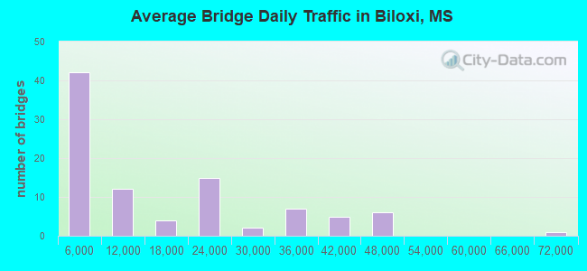
- 1,359,177Total average daily traffic
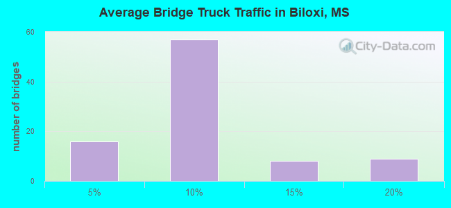
- 108,500Total average daily truck traffic
- National Bridge Inventory (NBI) Registered Bridges for Biloxi
- No street view available for this location
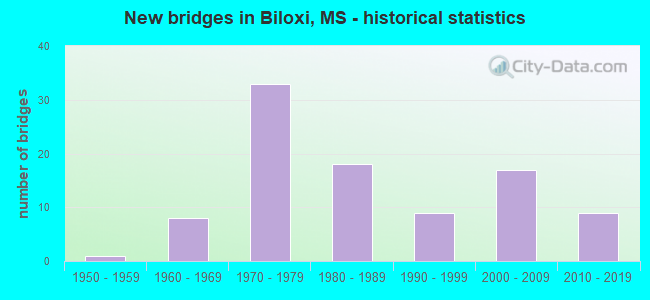
- New bridges - historical statistics
- 11950-1959
- 81960-1969
- 331970-1979
- 181980-1989
- 91990-1999
- 172000-2009
- 92010-2019
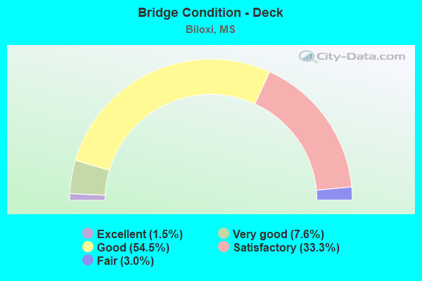
- Bridge Condition - Deck
- 1.5%Excellent
- 7.6%Very good
- 54.5%Good
- 33.3%Satisfactory
- 3.0%Fair
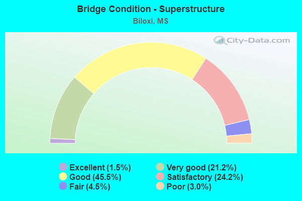
- Bridge Condition - Superstructure
- 1.5%Excellent
- 21.2%Very good
- 45.5%Good
- 24.2%Satisfactory
- 4.5%Fair
- 3.0%Poor
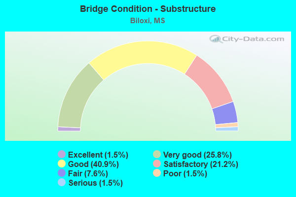
- Bridge Condition - Substructure
- 1.5%Excellent
- 25.8%Very good
- 40.9%Good
- 21.2%Satisfactory
- 7.6%Fair
- 1.5%Poor
- 1.5%Serious
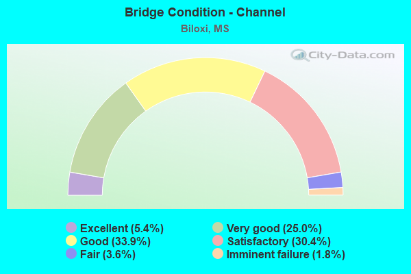
- Bridge Condition - Channel
- 5.4%Excellent
- 25.0%Very good
- 33.9%Good
- 30.4%Satisfactory
- 3.6%Fair
- 1.8%Imminent failure
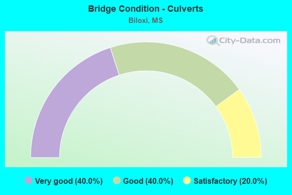
- Bridge Condition - Culverts
- 40.0%Very good
- 40.0%Good
- 20.0%Satisfactory
Find on map >> Show street view
Structure Number: 11000100240407A, Location: 2.5 MI W SR 67 (Lat: 30.449047, Lng: -89.005839), Route carried "on" structure: Interstate 10, Year Built: 1969, Year Reconstructed: 2000, Status: Open, Structure Length: 73.55m (241.31ft), Average Daily Traffic: 34,500 (year 2020), Truck Traffic: 12%, Average Future Daily Traffic: 36,500 (year 2040), Design Load: HS 20+Mod, Features Intersected: BILOXI RIVER
Minimum Vertical Clearance: 30+ m (98+ ft), Kilometerpoint: 12.567, Lanes on structure: 3, Base Highway Network: Yes (Inventory Route: 1, Subroute: 1), Owner: State Highway Agency, Approaching Roadway Width: 18.3m (60.0ft), Navigation Control: Yes ( Vertical Clearance: 12.0m (39.4ft), Horizontal Clearance: 30.0m (98.4ft)), Material/Design: Steel continuous, Design/Construction: Stringer/Multi-beam, Number Of Spans In Main Unit: 3, Number Of Approach Spans: 29, Length of Maximum Span: 54.9m (180.1ft), Curb-To-Curb Width: 18.0m (59.1ft), Out-to-Out Width: 18.9m (62.0ft)
Condition: Deck: Good, Superstructure: Satisfactory, Substructure: Fair, Channel: Satisfactory, Operating Rating: 62.6 metric tons, Method Used To Determine Operating Rating: Load Factor (LF), Inventory Rating: 30.7 metric tons, Method Used To Determine Inventory Rating: Load Factor (LF), Structural Evaluation: Somewhat better than minimum adequacy, Deck Geometry: Better than present minimum criteria, Waterway Adequacy: Equal to present desirable criteria, Approach Roadway Alignment: Equal to present desirable criteria, Designated Inspection Frequency: Every 24 months, Underwater Inspection Frequency: Every 60 months, Inspection Date: June 2021, Underwater Inspection Date: June 2019, Deck Structure Type: Concrete Cast-file-Place
Find on map >> Show street view
Structure Number: 11000100240425A, Location: 1.0 MI W SR 67 (Lat: 30.455694, Lng: -88.986547), Route carried "on" structure: Interstate 10, Year Built: 1969, Status: Open, Structure Length: 0.61m (2.00ft), Average Daily Traffic: 69,000 (year 2020), Truck Traffic: 12%, Average Future Daily Traffic: 73,000 (year 2040), Design Load: HS 20+Mod, Features Intersected: STREAM
Minimum Vertical Clearance: 30+ m (98+ ft), Kilometerpoint: 35.447, Lanes on structure: 6, Base Highway Network: Yes (Inventory Route: 1, Subroute: 1), Owner: State Highway Agency, Approaching Roadway Width: 15.8m (51.8ft), Material/Design: Concrete, Design/Construction: Culvert, Number Of Spans In Main Unit: 2, Length of Maximum Span: 3.0m (9.8ft)
Condition: Channel: Good, Culverts: Good, Structural Evaluation: Better than present minimum criteria, Waterway Adequacy: Equal to present desirable criteria, Approach Roadway Alignment: Equal to present desirable criteria, Designated Inspection Frequency: Every 24 months, Inspection Date: November 2021
Find on map >> Show street view
Structure Number: 11000100240435A, Location: I 10 OVER OLD SR 67 (Lat: 30.460733, Lng: -88.970408), Route carried "on" structure: Interstate 10, Year Built: 1970, Status: Open, Structure Length: 6.64m (21.78ft), Average Daily Traffic: 34,500 (year 2020), Truck Traffic: 12%, Average Future Daily Traffic: 36,500 (year 2040), Design Load: HS 20+Mod, Features Intersected: OLD SR 67
Minimum Vertical Clearance: 30+ m (98+ ft), Kilometerpoint: 8.826, Lanes on structure: 3, Lanes under structure: 2, Base Highway Network: Yes (Inventory Route: 1, Subroute: 1), Owner: State Highway Agency, Approaching Roadway Width: 18.1m (59.4ft), Material/Design: Prestressed concrete, Design/Construction: Stringer/Multi-beam, Number Of Spans In Main Unit: 1, Number Of Approach Spans: 2, Length of Maximum Span: 26.8m (87.9ft), Curb-To-Curb Width: 18.1m (59.4ft), Out-to-Out Width: 19.0m (62.3ft)
Condition: Deck: Good, Superstructure: Good, Substructure: Very good, Operating Rating: 65.9 metric tons, Method Used To Determine Operating Rating: Load Factor (LF), Inventory Rating: 32.7 metric tons, Method Used To Determine Inventory Rating: Load Factor (LF), Structural Evaluation: Better than present minimum criteria, Deck Geometry: Better than present minimum criteria, Underclear: Better than present minimum criteria, Approach Roadway Alignment: Equal to present desirable criteria, Designated Inspection Frequency: Every 24 months, Inspection Date: November 2021, Deck Structure Type: Concrete Cast-file-Place
Find on map >> Show street view
Structure Number: 11000100240435B, Location: I 10 OVER OLD SR 67 (Lat: 30.460525, Lng: -88.971092), Route carried "on" structure: Interstate 10, Year Built: 1970, Status: Open, Structure Length: 6.64m (21.78ft), Average Daily Traffic: 34,500 (year 2020), Truck Traffic: 12%, Average Future Daily Traffic: 36,500 (year 2040), Design Load: HS 20+Mod, Features Intersected: OLD SR 67
Minimum Vertical Clearance: 30+ m (98+ ft), Kilometerpoint: 37.071, Lanes on structure: 3, Lanes under structure: 2, Base Highway Network: Yes (Inventory Route: 1, Subroute: 1), Owner: State Highway Agency, Approaching Roadway Width: 18.1m (59.4ft), Material/Design: Prestressed concrete, Design/Construction: Stringer/Multi-beam, Number Of Spans In Main Unit: 1, Number Of Approach Spans: 2, Length of Maximum Span: 26.8m (87.9ft), Curb-To-Curb Width: 18.1m (59.4ft), Out-to-Out Width: 19.0m (62.3ft)
Condition: Deck: Good, Superstructure: Good, Substructure: Very good, Operating Rating: 65.9 metric tons, Method Used To Determine Operating Rating: Load Factor (LF), Inventory Rating: 32.8 metric tons, Method Used To Determine Inventory Rating: Load Factor (LF), Structural Evaluation: Better than present minimum criteria, Deck Geometry: Better than present minimum criteria, Underclear: Better than present minimum criteria, Approach Roadway Alignment: Equal to present desirable criteria, Designated Inspection Frequency: Every 24 months, Inspection Date: November 2021, Deck Structure Type: Concrete Cast-file-Place
Find on map >> Show street view
Structure Number: 11000100240438A, Location: 0.3 MI E SR 67 (Lat: 30.460733, Lng: -88.965436), Route carried "on" structure: Interstate 10, Year Built: 1970, Status: Open, Structure Length: 8.53m (27.99ft), Average Daily Traffic: 44,500 (year 2020), Truck Traffic: 8%, Average Future Daily Traffic: 47,500 (year 2040), Design Load: HS 20+Mod, Features Intersected: PARKER CREEK
Minimum Vertical Clearance: 30+ m (98+ ft), Kilometerpoint: 8.348, Lanes on structure: 3, Base Highway Network: Yes (Inventory Route: 1, Subroute: 1), Owner: State Highway Agency, Approaching Roadway Width: 18.1m (59.4ft), Material/Design: Prestressed concrete, Design/Construction: Stringer/Multi-beam, Number Of Spans In Main Unit: 7, Length of Maximum Span: 12.2m (40.0ft), Curb-To-Curb Width: 18.1m (59.4ft), Out-to-Out Width: 19.0m (62.3ft)
Condition: Deck: Good, Superstructure: Very good, Substructure: Very good, Channel: Good, Operating Rating: 59.7 metric tons, Method Used To Determine Operating Rating: Load Factor (LF), Inventory Rating: 33.7 metric tons, Method Used To Determine Inventory Rating: Load Factor (LF), Structural Evaluation: Equal to present desirable criteria, Deck Geometry: Better than present minimum criteria, Waterway Adequacy: Equal to present minimum criteria, Approach Roadway Alignment: Equal to present desirable criteria, Designated Inspection Frequency: Every 24 months, Inspection Date: November 2021, Deck Structure Type: Concrete Cast-file-Place
Find on map >> Show street view
Structure Number: 11000100240438B, Location: 0.3 MI E SR 67 (Lat: 30.460525, Lng: -88.966228), Route carried "on" structure: Interstate 10, Year Built: 1970, Status: Open, Structure Length: 8.53m (27.99ft), Average Daily Traffic: 44,500 (year 2020), Truck Traffic: 8%, Average Future Daily Traffic: 47,500 (year 2040), Design Load: HS 20+Mod, Features Intersected: PARKER CREEK
Minimum Vertical Clearance: 30+ m (98+ ft), Kilometerpoint: 37.538, Lanes on structure: 3, Base Highway Network: Yes (Inventory Route: 1, Subroute: 1), Owner: State Highway Agency, Approaching Roadway Width: 21.7m (71.2ft), Material/Design: Prestressed concrete, Design/Construction: Stringer/Multi-beam, Number Of Spans In Main Unit: 7, Length of Maximum Span: 12.2m (40.0ft), Curb-To-Curb Width: 21.7m (71.2ft), Out-to-Out Width: 22.2m (72.8ft)
Condition: Deck: Good, Superstructure: Very good, Substructure: Good, Channel: Satisfactory, Operating Rating: 63.8 metric tons, Method Used To Determine Operating Rating: Load Factor (LF), Inventory Rating: 37.0 metric tons, Method Used To Determine Inventory Rating: Load Factor (LF), Structural Evaluation: Better than present minimum criteria, Deck Geometry: Superior to present desirable criteria, Waterway Adequacy: Equal to present minimum criteria, Approach Roadway Alignment: Equal to present desirable criteria, Designated Inspection Frequency: Every 24 months, Inspection Date: November 2021, Deck Structure Type: Concrete Cast-file-Place
Find on map >> Show street view
Structure Number: 11000100240450A, Location: 1.6 MI E SR 67 (Lat: 30.453028, Lng: -88.941678), Route carried "on" structure: Interstate 10, Year Built: 1969, Status: Open, Structure Length: 75.77m (248.59ft), Average Daily Traffic: 44,500 (year 2020), Truck Traffic: 8%, Average Future Daily Traffic: 47,500 (year 2040), Design Load: HS 20+Mod, Features Intersected: TCHOUTACABOUFFA RIVER
Minimum Vertical Clearance: 30+ m (98+ ft), Kilometerpoint: 5.842, Lanes on structure: 3, Base Highway Network: Yes (Inventory Route: 1, Subroute: 1), Owner: State Highway Agency, Approaching Roadway Width: 18.1m (59.4ft), Navigation Control: Yes ( Vertical Clearance: 13.0m (42.7ft), Horizontal Clearance: 30.0m (98.4ft)), Material/Design: Steel continuous, Design/Construction: Stringer/Multi-beam, Number Of Spans In Main Unit: 3, Number Of Approach Spans: 32, Length of Maximum Span: 42.7m (140.1ft), Curb-To-Curb Width: 18.1m (59.4ft), Out-to-Out Width: 19.0m (62.3ft)
Condition: Deck: Satisfactory, Superstructure: Satisfactory, Substructure: Fair, Channel: Satisfactory, Operating Rating: 59.0 metric tons, Method Used To Determine Operating Rating: Load Factor (LF), Inventory Rating: 30.7 metric tons, Method Used To Determine Inventory Rating: Load Factor (LF), Structural Evaluation: Somewhat better than minimum adequacy, Deck Geometry: Better than present minimum criteria, Waterway Adequacy: Equal to present desirable criteria, Approach Roadway Alignment: Equal to present desirable criteria, Designated Inspection Frequency: Every 24 months, Underwater Inspection Frequency: Every 60 months, Inspection Date: June 2021, Underwater Inspection Date: June 2019, Deck Structure Type: Concrete Cast-file-Place
Find on map >> Show street view
Structure Number: 11000100240450B, Location: 1.6 MI E SR 67 (Lat: 30.456447, Lng: -88.948578), Route carried "on" structure: Interstate 10, Year Built: 1969, Status: Open, Structure Length: 75.77m (248.59ft), Average Daily Traffic: 44,500 (year 2020), Truck Traffic: 8%, Average Future Daily Traffic: 47,500 (year 2040), Design Load: HS 20+Mod, Features Intersected: TCHOUTACABOUFFA RIVER
Minimum Vertical Clearance: 30+ m (98+ ft), Kilometerpoint: 39.339, Lanes on structure: 3, Base Highway Network: Yes (Inventory Route: 1, Subroute: 1), Owner: State Highway Agency, Approaching Roadway Width: 18.1m (59.4ft), Navigation Control: Yes ( Vertical Clearance: 13.0m (42.7ft), Horizontal Clearance: 30.0m (98.4ft)), Material/Design: Steel continuous, Design/Construction: Stringer/Multi-beam, Number Of Spans In Main Unit: 3, Number Of Approach Spans: 32, Length of Maximum Span: 42.7m (140.1ft), Curb-To-Curb Width: 18.1m (59.4ft), Out-to-Out Width: 19.0m (62.3ft)
Condition: Deck: Good, Superstructure: Satisfactory, Substructure: Satisfactory, Channel: Satisfactory, Operating Rating: 59.0 metric tons, Method Used To Determine Operating Rating: Load Factor (LF), Inventory Rating: 30.7 metric tons, Method Used To Determine Inventory Rating: Load Factor (LF), Structural Evaluation: Equal to present minimum criteria, Deck Geometry: Better than present minimum criteria, Waterway Adequacy: Equal to present desirable criteria, Approach Roadway Alignment: Equal to present desirable criteria, Designated Inspection Frequency: Every 24 months, Underwater Inspection Frequency: Every 60 months, Inspection Date: June 2021, Underwater Inspection Date: June 2019, Deck Structure Type: Concrete Cast-file-Place
Find on map >> Show street view
Structure Number: 11000100240460A, Location: 2.4 MI E SR 67 (Lat: 30.449489, Lng: -88.933908), Route carried "on" structure: Interstate 10, Year Built: 1970, Status: Open, Structure Length: 7.39m (24.25ft), Average Daily Traffic: 44,500 (year 2020), Truck Traffic: 8%, Average Future Daily Traffic: 47,500 (year 2040), Design Load: HS 20+Mod, Features Intersected: CEDAR LAKE ROAD
Minimum Vertical Clearance: 30+ m (98+ ft), Kilometerpoint: 4.997, Lanes on structure: 3, Lanes under structure: 5, Base Highway Network: Yes (Inventory Route: 1, Subroute: 1), Owner: State Highway Agency, Approaching Roadway Width: 18.1m (59.4ft), Skew: 2 degrees, Material/Design: Prestressed concrete, Design/Construction: Stringer/Multi-beam, Number Of Spans In Main Unit: 1, Number Of Approach Spans: 2, Length of Maximum Span: 29.0m (95.1ft), Curb-To-Curb Width: 18.1m (59.4ft), Out-to-Out Width: 19.0m (62.3ft)
Condition: Deck: Good, Superstructure: Very good, Substructure: Very good, Operating Rating: 63.5 metric tons, Method Used To Determine Operating Rating: Load Factor (LF), Inventory Rating: 33.9 metric tons, Method Used To Determine Inventory Rating: Load Factor (LF), Structural Evaluation: Equal to present desirable criteria, Deck Geometry: Better than present minimum criteria, Underclear: Better than present minimum criteria, Approach Roadway Alignment: Equal to present desirable criteria, Designated Inspection Frequency: Every 24 months, Inspection Date: November 2021, Deck Structure Type: Concrete Cast-file-Place
Find on map >> Show street view
Structure Number: 11000100240460B, Location: 2.4 MI E SR 67 (Lat: 30.449283, Lng: -88.934611), Route carried "on" structure: Interstate 10, Year Built: 1970, Status: Open, Structure Length: 7.39m (24.25ft), Average Daily Traffic: 44,500 (year 2020), Truck Traffic: 8%, Average Future Daily Traffic: 47,500 (year 2040), Design Load: HS 20+Mod, Features Intersected: CEDAR LAKE ROAD
Minimum Vertical Clearance: 30+ m (98+ ft), Kilometerpoint: 40.900, Lanes on structure: 3, Lanes under structure: 2, Base Highway Network: Yes (Inventory Route: 1, Subroute: 1), Owner: State Highway Agency, Approaching Roadway Width: 18.1m (59.4ft), Skew: 2 degrees, Material/Design: Prestressed concrete, Design/Construction: Stringer/Multi-beam, Number Of Spans In Main Unit: 1, Number Of Approach Spans: 2, Length of Maximum Span: 29.0m (95.1ft), Curb-To-Curb Width: 18.1m (59.4ft), Out-to-Out Width: 19.0m (62.3ft)
Condition: Deck: Good, Superstructure: Good, Substructure: Very good, Operating Rating: 63.5 metric tons, Method Used To Determine Operating Rating: Load Factor (LF), Inventory Rating: 33.9 metric tons, Method Used To Determine Inventory Rating: Load Factor (LF), Structural Evaluation: Better than present minimum criteria, Deck Geometry: Better than present minimum criteria, Underclear: Better than present minimum criteria, Approach Roadway Alignment: Equal to present desirable criteria, Designated Inspection Frequency: Every 24 months, Inspection Date: November 2021, Deck Structure Type: Concrete Cast-file-Place
Find on map >> Show street view
Structure Number: 11001100240001, Location: 0.1 MI N US 90 (Lat: 30.396367, Lng: -88.894339), Route carried "on" structure: Interstate 110, Year Built: 1988, Status: Open, Structure Length: 161.64m (530.31ft), Average Daily Traffic: 22,000 (year 2020), Truck Traffic: 4%, Average Future Daily Traffic: 23,000 (year 2040), Design Load: HS 20, Features Intersected: L&N RR AND KEEGAN BAYOU
Minimum Vertical Clearance: 30+ m (98+ ft), Kilometerpoint: 0.006, Lanes on structure: 4, Lanes under structure: 10, Base Highway Network: Yes (Inventory Route: 11, Subroute: 1), Owner: State Highway Agency, Approaching Roadway Width: 25.6m (84.0ft), Skew: 30 degrees, Material/Design: Prestressed concrete continuous, Design/Construction: Segmental Box Girder, Number Of Spans In Main Unit: 44, Length of Maximum Span: 39.6m (129.9ft), Curb-To-Curb Width: 23.5m (77.1ft), Out-to-Out Width: 25.2m (82.7ft)
Condition: Deck: Good, Superstructure: Good, Substructure: Good, Channel: Good, Operating Rating: 55.2 metric tons, Method Used To Determine Operating Rating: Load Factor (LF), Inventory Rating: 33.0 metric tons, Method Used To Determine Inventory Rating: Load Factor (LF), Structural Evaluation: Better than present minimum criteria, Deck Geometry: Superior to present desirable criteria, Underclear: Better than present minimum criteria, Waterway Adequacy: Equal to present desirable criteria, Approach Roadway Alignment: Equal to present desirable criteria, Designated Inspection Frequency: Every 24 months, Underwater Inspection Frequency: Every 60 months, Inspection Date: December 2021, Underwater Inspection Date: June 2019, Deck Structure Type: Concrete Cast-file-Place
Find on map >> Show street view
Structure Number: 11001100240013, Location: 1.3 MI N US 90 (Lat: 30.411233, Lng: -88.893853), Route carried "on" structure: Interstate 110, Year Built: 1973, Status: Open, Structure Length: 174.59m (572.80ft), Average Daily Traffic: 37,000 (year 2020), Truck Traffic: 4%, Average Future Daily Traffic: 39,000 (year 2040), Design Load: HS 20, Features Intersected: BILOXI BACK BAY
Minimum Vertical Clearance: 30+ m (98+ ft), Kilometerpoint: 1.664, Lanes on structure: 4, Base Highway Network: Yes (Inventory Route: 11, Subroute: 1), Owner: State Highway Agency, Approaching Roadway Width: 25.6m (84.0ft), Skew: 30 degrees, Navigation Control: Yes ( Vertical Clearance: 18.0m (59.1ft), Horizontal Clearance: 40.0m (131.2ft)), Material/Design: Steel, Design/Construction: Movable - Bascule, Number Of Spans In Main Unit: 1, Number Of Approach Spans: 56, Length of Maximum Span: 76.2m (250.0ft), Curb or Sidewalk Widths: Left: 0.0m, Right: 1.9m (6.2ft), Curb-To-Curb Width: 23.5m (77.1ft), Out-to-Out Width: 27.0m (88.6ft)
Condition: Deck: Good, Superstructure: Satisfactory, Substructure: Fair, Channel: Satisfactory, Operating Rating: 60.0 metric tons, Method Used To Determine Operating Rating: Load Factor (LF), Inventory Rating: 45.1 metric tons, Method Used To Determine Inventory Rating: Load Factor (LF), Structural Evaluation: Somewhat better than minimum adequacy, Deck Geometry: Superior to present desirable criteria, Waterway Adequacy: Equal to present desirable criteria, Approach Roadway Alignment: Equal to present desirable criteria, Designated Inspection Frequency: Every 24 months, Critical Feature Inspection Frequency: Every 12 months, Underwater Inspection Frequency: Every 60 months, Other Special Inspection Frequency: Every 72 months, Inspection Date: August 2020, Critical Feature Inspection Date: August 2021, Underwater Inspection Date: May 2019, Other Special Inspection Date: August 2018, Deck Structure Type: Concrete Cast-file-Place
Find on map >> Show street view
Structure Number: 11001100240025A, Location: 1.5 MI S I 10 (Lat: 30.430364, Lng: -88.894931), Route carried "on" structure: Interstate 110, Year Built: 1973, Status: Open, Structure Length: 8.60m (28.22ft), Average Daily Traffic: 24,000 (year 2020), Truck Traffic: 5%, Average Future Daily Traffic: 25,500 (year 2040), Design Load: HS 20+Mod, Features Intersected: RODRIGUEZ STREET
Minimum Vertical Clearance: 30+ m (98+ ft), Kilometerpoint: 2.626, Lanes on structure: 2, Lanes under structure: 5, Base Highway Network: Yes (Inventory Route: 11, Subroute: 1), Owner: State Highway Agency, Approaching Roadway Width: 12.8m (42.0ft), Skew: 1 degrees, Material/Design: Concrete continuous, Design/Construction: Box Beam or Girders - Single/Spread, Number Of Spans In Main Unit: 1, Number Of Approach Spans: 2, Length of Maximum Span: 42.7m (140.1ft), Curb-To-Curb Width: 12.3m (40.4ft), Out-to-Out Width: 13.4m (44.0ft)
Condition: Deck: Satisfactory, Superstructure: Satisfactory, Substructure: Good, Operating Rating: 92.3 metric tons, Method Used To Determine Operating Rating: Load Factor (LF), Inventory Rating: 55.7 metric tons, Method Used To Determine Inventory Rating: Load Factor (LF), Structural Evaluation: Equal to present minimum criteria, Deck Geometry: Better than present minimum criteria, Underclear: Better than present minimum criteria, Approach Roadway Alignment: Equal to present desirable criteria, Designated Inspection Frequency: Every 24 months, Inspection Date: December 2021, Deck Structure Type: Concrete Cast-file-Place
Find on map >> Show street view
Structure Number: 11001100240025B, Location: 1.5 MI S I 10 (Lat: 30.429544, Lng: -88.894747), Route carried "on" structure: Interstate 110, Year Built: 1973, Status: Open, Structure Length: 8.60m (28.22ft), Average Daily Traffic: 24,000 (year 2020), Truck Traffic: 5%, Average Future Daily Traffic: 25,500 (year 2040), Design Load: HS 20+Mod, Features Intersected: RODRIGUEZ STREET
Minimum Vertical Clearance: 30+ m (98+ ft), Kilometerpoint: 3.697, Lanes on structure: 2, Lanes under structure: 5, Base Highway Network: Yes (Inventory Route: 11, Subroute: 1), Owner: State Highway Agency, Approaching Roadway Width: 12.8m (42.0ft), Skew: 1 degrees, Material/Design: Concrete continuous, Design/Construction: Box Beam or Girders - Single/Spread, Number Of Spans In Main Unit: 1, Number Of Approach Spans: 2, Length of Maximum Span: 42.7m (140.1ft), Curb-To-Curb Width: 12.3m (40.4ft), Out-to-Out Width: 13.4m (44.0ft)
Condition: Deck: Satisfactory, Superstructure: Satisfactory, Substructure: Very good, Operating Rating: 94.3 metric tons, Method Used To Determine Operating Rating: Load Factor (LF), Inventory Rating: 56.7 metric tons, Method Used To Determine Inventory Rating: Load Factor (LF), Structural Evaluation: Equal to present minimum criteria, Deck Geometry: Better than present minimum criteria, Underclear: Superior to present desirable criteria, Approach Roadway Alignment: Equal to present desirable criteria, Designated Inspection Frequency: Every 24 months, Inspection Date: December 2021, Deck Structure Type: Concrete Cast-file-Place
Find on map >> Show street view
Structure Number: 11001100240031A, Location: 0.9 MI S I 10 (Lat: 30.438847, Lng: -88.895039), Route carried "on" structure: Interstate 110, Year Built: 1973, Status: Open, Structure Length: 11.31m (37.11ft), Average Daily Traffic: 19,000 (year 2020), Truck Traffic: 4%, Average Future Daily Traffic: 20,000 (year 2040), Design Load: HS 20+Mod, Features Intersected: D'IBERVILLE BLVD
Minimum Vertical Clearance: 30+ m (98+ ft), Kilometerpoint: 1.687, Lanes on structure: 2, Lanes under structure: 3, Base Highway Network: Yes (Inventory Route: 11, Subroute: 1), Owner: State Highway Agency, Approaching Roadway Width: 12.8m (42.0ft), Skew: 4 degrees, Material/Design: Concrete continuous, Design/Construction: Box Beam or Girders - Single/Spread, Number Of Spans In Main Unit: 1, Number Of Approach Spans: 2, Length of Maximum Span: 46.6m (152.9ft), Curb-To-Curb Width: 12.3m (40.4ft), Out-to-Out Width: 13.4m (44.0ft)
Condition: Deck: Good, Superstructure: Good, Substructure: Good, Operating Rating: 50.8 metric tons, Method Used To Determine Operating Rating: Load Factor (LF), Inventory Rating: 30.8 metric tons, Method Used To Determine Inventory Rating: Load Factor (LF), Structural Evaluation: Better than present minimum criteria, Deck Geometry: Better than present minimum criteria, Underclear: Better than present minimum criteria, Approach Roadway Alignment: Equal to present desirable criteria, Designated Inspection Frequency: Every 24 months, Inspection Date: December 2021, Deck Structure Type: Concrete Cast-file-Place
Find on map >> Show street view
Structure Number: 11001100240031B, Location: 0.9 MI S I 10 (Lat: 30.437689, Lng: -88.894819), Route carried "on" structure: Interstate 110, Year Built: 1973, Status: Open, Structure Length: 11.31m (37.11ft), Average Daily Traffic: 19,000 (year 2020), Truck Traffic: 4%, Average Future Daily Traffic: 20,000 (year 2040), Design Load: HS 20+Mod, Features Intersected: D'IBERVILLE BLVD
Minimum Vertical Clearance: 30+ m (98+ ft), Kilometerpoint: 4.600, Lanes on structure: 2, Lanes under structure: 3, Base Highway Network: Yes (Inventory Route: 11, Subroute: 1), Owner: State Highway Agency, Approaching Roadway Width: 12.8m (42.0ft), Skew: 4 degrees, Material/Design: Concrete continuous, Design/Construction: Box Beam or Girders - Single/Spread, Number Of Spans In Main Unit: 1, Number Of Approach Spans: 2, Length of Maximum Span: 46.6m (152.9ft), Curb-To-Curb Width: 12.3m (40.4ft), Out-to-Out Width: 13.4m (44.0ft)
Condition: Deck: Good, Superstructure: Good, Substructure: Good, Operating Rating: 50.8 metric tons, Method Used To Determine Operating Rating: Load Factor (LF), Inventory Rating: 30.8 metric tons, Method Used To Determine Inventory Rating: Load Factor (LF), Structural Evaluation: Better than present minimum criteria, Deck Geometry: Better than present minimum criteria, Underclear: Better than present minimum criteria, Approach Roadway Alignment: Equal to present desirable criteria, Designated Inspection Frequency: Every 24 months, Inspection Date: December 2021, Deck Structure Type: Concrete Cast-file-Place
Find on map >> Show street view
Structure Number: 11001100240041A, Location: I 110 OVER I 10 (Lat: 30.453894, Lng: -88.896467), Route carried "on" structure: Interstate 110, Year Built: 1970, Status: Open, Structure Length: 14.39m (47.21ft), Average Daily Traffic: 19,000 (year 2020), Truck Traffic: 4%, Average Future Daily Traffic: 20,000 (year 2040), Design Load: HS 20+Mod, Features Intersected: I 10
Minimum Vertical Clearance: 30+ m (98+ ft), Kilometerpoint: 0.002, Lanes on structure: 2, Lanes under structure: 8, Base Highway Network: Yes (Inventory Route: 11, Subroute: 1), Owner: State Highway Agency, Approaching Roadway Width: 15.2m (49.9ft), Material/Design: Concrete continuous, Design/Construction: Box Beam or Girders - Single/Spread, Number Of Spans In Main Unit: 3, Number Of Approach Spans: 2, Length of Maximum Span: 37.2m (122.0ft), Curb-To-Curb Width: 14.8m (48.6ft), Out-to-Out Width: 15.8m (51.8ft)
Condition: Deck: Good, Superstructure: Good, Substructure: Good, Operating Rating: 58.3 metric tons, Method Used To Determine Operating Rating: Load Factor (LF), Inventory Rating: 35.1 metric tons, Method Used To Determine Inventory Rating: Load Factor (LF), Structural Evaluation: Better than present minimum criteria, Deck Geometry: Superior to present desirable criteria, Underclear: Superior to present desirable criteria, Approach Roadway Alignment: Equal to present desirable criteria, Designated Inspection Frequency: Every 24 months, Inspection Date: December 2021, Deck Structure Type: Concrete Cast-file-Place
Find on map >> Show street view
Structure Number: 11001100240041B, Location: I 110 OVER I 10 (Lat: 30.452739, Lng: -88.895767), Route carried "on" structure: Interstate 110, Year Built: 1970, Status: Open, Structure Length: 14.39m (47.21ft), Average Daily Traffic: 19,000 (year 2020), Truck Traffic: 4%, Average Future Daily Traffic: 20,000 (year 2040), Design Load: HS 20+Mod, Features Intersected: I 10
Minimum Vertical Clearance: 30+ m (98+ ft), Kilometerpoint: 6.276, Lanes on structure: 2, Lanes under structure: 8, Base Highway Network: Yes (Inventory Route: 11, Subroute: 1), Owner: State Highway Agency, Approaching Roadway Width: 15.2m (49.9ft), Material/Design: Concrete continuous, Design/Construction: Box Beam or Girders - Single/Spread, Number Of Spans In Main Unit: 3, Number Of Approach Spans: 2, Length of Maximum Span: 37.2m (122.0ft), Curb-To-Curb Width: 14.8m (48.6ft), Out-to-Out Width: 15.8m (51.8ft)
Condition: Deck: Good, Superstructure: Good, Substructure: Good, Operating Rating: 58.3 metric tons, Method Used To Determine Operating Rating: Load Factor (LF), Inventory Rating: 35.1 metric tons, Method Used To Determine Inventory Rating: Load Factor (LF), Structural Evaluation: Better than present minimum criteria, Deck Geometry: Superior to present desirable criteria, Underclear: Superior to present desirable criteria, Approach Roadway Alignment: Equal to present desirable criteria, Designated Inspection Frequency: Every 24 months, Inspection Date: December 2021, Deck Structure Type: Concrete Cast-file-Place
Find on map >> Show street view
Structure Number: 17001100240000A, Location: JCT US 90 & I 110 (Lat: 30.399133, Lng: -88.895042), Route carried "on" structure: Ramp Interstate 110, Year Built: 1988, Status: Open, Structure Length: 85.46m (280.38ft), Average Daily Traffic: 2,250 (year 2020), Truck Traffic: 18%, Average Future Daily Traffic: 2,400 (year 2040), Design Load: HS 20, Features Intersected: US 90
Minimum Vertical Clearance: 30+ m (98+ ft), Kilometerpoint: 0.200, Lanes on structure: 1, Lanes under structure: 11, Owner: State Highway Agency, Approaching Roadway Width: 8.4m (27.6ft), Material/Design: Prestressed concrete continuous, Design/Construction: Segmental Box Girder, Number Of Spans In Main Unit: 15, Number Of Approach Spans: 13, Length of Maximum Span: 48.8m (160.1ft), Curb-To-Curb Width: 8.4m (27.6ft), Out-to-Out Width: 8.8m (28.9ft)
Condition: Deck: Good, Superstructure: Good, Substructure: Very good, Channel: Very good, Operating Rating: 56.8 metric tons, Method Used To Determine Operating Rating: Load Factor (LF), Inventory Rating: 34.0 metric tons, Method Used To Determine Inventory Rating: Load Factor (LF), Structural Evaluation: Better than present minimum criteria, Deck Geometry: Superior to present desirable criteria, Underclear: Meets minimum limits, Waterway Adequacy: Equal to present desirable criteria, Approach Roadway Alignment: Equal to present minimum criteria, Designated Inspection Frequency: Every 24 months, Inspection Date: December 2021, Deck Structure Type: Concrete Cast-file-Place
Find on map >> Show street view
Structure Number: 17001100240000B, Location: JCT US 90 & I 110 (Lat: 30.394014, Lng: -88.896911), Route carried "on" structure: Ramp Interstate 110, Year Built: 1988, Status: Open, Structure Length: 81.65m (267.88ft), Average Daily Traffic: 2,500 (year 2020), Truck Traffic: 18%, Average Future Daily Traffic: 2,650 (year 2040), Design Load: HS 20, Features Intersected: US 90
Minimum Vertical Clearance: 30+ m (98+ ft), Kilometerpoint: 0.169, Lanes on structure: 1, Lanes under structure: 7, Owner: State Highway Agency, Approaching Roadway Width: 8.4m (27.6ft), Material/Design: Prestressed concrete continuous, Design/Construction: Segmental Box Girder, Number Of Spans In Main Unit: 12, Number Of Approach Spans: 14, Length of Maximum Span: 54.7m (179.5ft), Curb-To-Curb Width: 8.4m (27.6ft), Out-to-Out Width: 8.8m (28.9ft)
Condition: Deck: Good, Superstructure: Good, Substructure: Good, Channel: Very good, Operating Rating: 56.8 metric tons, Method Used To Determine Operating Rating: Load Factor (LF), Inventory Rating: 34.0 metric tons, Method Used To Determine Inventory Rating: Load Factor (LF), Structural Evaluation: Better than present minimum criteria, Deck Geometry: Superior to present desirable criteria, Underclear: Equal to present minimum criteria, Waterway Adequacy: Equal to present desirable criteria, Approach Roadway Alignment: Equal to present minimum criteria, Designated Inspection Frequency: Every 24 months, Inspection Date: December 2021, Deck Structure Type: Concrete Cast-file-Place
Find on map >> Show street view
Structure Number: 17001100240008A, Location: 0.8 MI N US 90 (Lat: 30.406653, Lng: -88.894544), Route carried "on" structure: Ramp Interstate 110, Year Built: 1988, Status: Open, Structure Length: 22.56m (74.02ft), Average Daily Traffic: 3,100 (year 2020), Truck Traffic: 18%, Average Future Daily Traffic: 3,300 (year 2040), Design Load: HS 20, Features Intersected: PERCY STREET
Minimum Vertical Clearance: 30+ m (98+ ft), Kilometerpoint: 0.216, Lanes on structure: 1, Lanes under structure: 2, Owner: State Highway Agency, Approaching Roadway Width: 8.8m (28.9ft), Material/Design: Prestressed concrete continuous, Design/Construction: Segmental Box Girder, Number Of Spans In Main Unit: 6, Length of Maximum Span: 42.7m (140.1ft), Curb-To-Curb Width: 8.4m (27.6ft), Out-to-Out Width: 8.8m (28.9ft)
Condition: Deck: Very good, Superstructure: Very good, Substructure: Very good, Operating Rating: 56.8 metric tons, Method Used To Determine Operating Rating: Load Factor (LF), Inventory Rating: 34.0 metric tons, Method Used To Determine Inventory Rating: Load Factor (LF), Structural Evaluation: Equal to present desirable criteria, Deck Geometry: Superior to present desirable criteria, Underclear: Equal to present minimum criteria, Approach Roadway Alignment: Equal to present desirable criteria, Designated Inspection Frequency: Every 24 months, Inspection Date: December 2021, Deck Structure Type: Concrete Cast-file-Place
Find on map >> Show street view
Structure Number: 17001100240008B, Location: 0.8 MI N US 90 (Lat: 30.404814, Lng: -88.894203), Route carried "on" structure: Ramp Interstate 110, Year Built: 1988, Status: Open, Structure Length: 16.15m (52.99ft), Average Daily Traffic: 2,700 (year 2020), Truck Traffic: 18%, Average Future Daily Traffic: 2,800 (year 2040), Design Load: HS 20, Features Intersected: PERCY STREET
Minimum Vertical Clearance: 30+ m (98+ ft), Kilometerpoint: 0.130, Lanes on structure: 1, Lanes under structure: 2, Owner: State Highway Agency, Approaching Roadway Width: 8.8m (28.9ft), Material/Design: Prestressed concrete continuous, Design/Construction: Segmental Box Girder, Number Of Spans In Main Unit: 4, Length of Maximum Span: 42.7m (140.1ft), Curb-To-Curb Width: 8.4m (27.6ft), Out-to-Out Width: 8.8m (28.9ft)
Condition: Deck: Good, Superstructure: Good, Substructure: Very good, Operating Rating: 56.8 metric tons, Method Used To Determine Operating Rating: Load Factor (LF), Inventory Rating: 34.0 metric tons, Method Used To Determine Inventory Rating: Load Factor (LF), Structural Evaluation: Better than present minimum criteria, Deck Geometry: Superior to present desirable criteria, Underclear: Equal to present minimum criteria, Approach Roadway Alignment: Equal to present desirable criteria, Designated Inspection Frequency: Every 24 months, Inspection Date: December 2021, Deck Structure Type: Concrete Cast-file-Place
Find on map >> Show street view
Structure Number: 17001100240011, Location: 1.1 MI N US 90 (Lat: 30.410192, Lng: -88.892886), Route carried "on" structure: Ramp Interstate 110, Year Built: 1988, Status: Open, Structure Length: 12.98m (42.59ft), Average Daily Traffic: 3,200 (year 2020), Truck Traffic: 18%, Average Future Daily Traffic: 3,400 (year 2040), Design Load: HS 20, Features Intersected: CHARTRES STREET
Minimum Vertical Clearance: 30+ m (98+ ft), Kilometerpoint: 0.185, Lanes on structure: 1, Owner: State Highway Agency, Approaching Roadway Width: 10.0m (32.8ft), Material/Design: Concrete continuous, Design/Construction: Box Beam or Girders - Single/Spread, Number Of Spans In Main Unit: 6, Length of Maximum Span: 21.6m (70.9ft), Curb-To-Curb Width: 9.1m (29.9ft), Out-to-Out Width: 10.0m (32.8ft)
Condition: Deck: Good, Superstructure: Very good, Substructure: Very good, Operating Rating: 45.0 metric tons, Method Used To Determine Operating Rating: Allowable Stress (AS), Inventory Rating: 32.4 metric tons, Method Used To Determine Inventory Rating: Allowable Stress (AS), Structural Evaluation: Equal to present desirable criteria, Deck Geometry: Superior to present desirable criteria, Approach Roadway Alignment: Equal to present desirable criteria, Designated Inspection Frequency: Every 24 months, Inspection Date: December 2021, Deck Structure Type: Concrete Cast-file-Place
Find on map >> Show street view
Structure Number: 17001100240012A, Location: 1.2 MI N US 90 (Lat: 30.414356, Lng: -88.894189), Route carried "on" structure: Ramp Interstate 110, Year Built: 1988, Status: Open, Structure Length: 20.93m (68.67ft), Average Daily Traffic: 4,800 (year 2020), Truck Traffic: 18%, Average Future Daily Traffic: 5,000 (year 2040), Design Load: HS 20, Features Intersected: BILOXI BACK BAY
Minimum Vertical Clearance: 30+ m (98+ ft), Kilometerpoint: 0.204, Lanes on structure: 1, Owner: State Highway Agency, Approaching Roadway Width: 8.1m (26.6ft), Material/Design: Prestressed concrete, Design/Construction: Stringer/Multi-beam, Number Of Spans In Main Unit: 8, Length of Maximum Span: 27.1m (88.9ft), Curb-To-Curb Width: 7.2m (23.6ft), Out-to-Out Width: 8.2m (26.9ft)
Condition: Deck: Good, Superstructure: Very good, Substructure: Good, Channel: Good, Operating Rating: 83.4 metric tons, Method Used To Determine Operating Rating: Load Factor (LF), Inventory Rating: 49.4 metric tons, Method Used To Determine Inventory Rating: Load Factor (LF), Structural Evaluation: Better than present minimum criteria, Deck Geometry: Equal to present minimum criteria, Waterway Adequacy: Equal to present desirable criteria, Approach Roadway Alignment: Equal to present desirable criteria, Designated Inspection Frequency: Every 24 months, Underwater Inspection Frequency: Every 60 months, Inspection Date: December 2021, Underwater Inspection Date: May 2019, Deck Structure Type: Concrete Cast-file-Place
Find on map >> Show street view
Structure Number: 17001100240012B, Location: 1.2 MI N US 90 (Lat: 30.412303, Lng: -88.893522), Route carried "on" structure: Ramp Interstate 110, Year Built: 1988, Status: Open, Structure Length: 23.14m (75.92ft), Average Daily Traffic: 1,750 (year 2020), Truck Traffic: 18%, Average Future Daily Traffic: 1,850 (year 2040), Design Load: HS 20, Features Intersected: BILOXI BACK BAY
Minimum Vertical Clearance: 30+ m (98+ ft), Kilometerpoint: 0.085, Lanes on structure: 1, Owner: State Highway Agency, Approaching Roadway Width: 8.1m (26.6ft), Material/Design: Prestressed concrete, Design/Construction: Stringer/Multi-beam, Number Of Spans In Main Unit: 1, Number Of Approach Spans: 8, Length of Maximum Span: 28.9m (94.8ft), Curb or Sidewalk Widths: Left: 0.0m, Right: 1.9m (6.2ft), Curb-To-Curb Width: 7.2m (23.6ft), Out-to-Out Width: 10.0m (32.8ft)
Condition: Deck: Good, Superstructure: Very good, Substructure: Good, Channel: Good, Operating Rating: 65.5 metric tons, Method Used To Determine Operating Rating: Load Factor (LF), Inventory Rating: 35.2 metric tons, Method Used To Determine Inventory Rating: Load Factor (LF), Structural Evaluation: Better than present minimum criteria, Deck Geometry: Equal to present minimum criteria, Waterway Adequacy: Equal to present desirable criteria, Approach Roadway Alignment: Equal to present desirable criteria, Designated Inspection Frequency: Every 24 months, Underwater Inspection Frequency: Every 60 months, Inspection Date: December 2021, Underwater Inspection Date: May 2019, Deck Structure Type: Concrete Cast-file-Place
Find on map >> Show street view
Structure Number: 21000900240494A, Location: HARRISON/JACKSON CL (Lat: 30.411092, Lng: -88.841058), Route carried "on" structure: US 90, Year Built: 2008, Status: Open, Structure Length: 267.18m (876.57ft), Average Daily Traffic: 11,500 (year 2020), Truck Traffic: 2%, Average Future Daily Traffic: 11,500 (year 2040), Design Load: HS 20, Features Intersected: BILOXI BAY
Minimum Vertical Clearance: 30+ m (98+ ft), Kilometerpoint: 0.000, Lanes on structure: 3, Base Highway Network: Yes (Inventory Route: 9, Subroute: 1), Owner: State Highway Agency, Approaching Roadway Width: 17.4m (57.1ft), Skew: 30 degrees, Navigation Control: Yes ( Vertical Clearance: 29.2m (95.8ft), Horizontal Clearance: 45.7m (149.9ft)), Material/Design: Prestressed concrete continuous, Design/Construction: Stringer/Multi-beam, Number Of Spans In Main Unit: 1, Number Of Approach Spans: 70, Length of Maximum Span: 76.2m (250.0ft), Curb-To-Curb Width: 17.4m (57.1ft), Out-to-Out Width: 18.3m (60.0ft)
Condition: Deck: Very good, Superstructure: Good, Substructure: Good, Channel: Good, Operating Rating: 55.0 metric tons, Method Used To Determine Operating Rating: Load Factor (LF), Inventory Rating: 33.0 metric tons, Method Used To Determine Inventory Rating: Load Factor (LF), Structural Evaluation: Better than present minimum criteria, Deck Geometry: Superior to present desirable criteria, Waterway Adequacy: Superior to present desirable criteria, Approach Roadway Alignment: Better than present minimum criteria, Designated Inspection Frequency: Every 24 months, Underwater Inspection Frequency: Every 60 months, Inspection Date: July 2020, Underwater Inspection Date: March 2019, Deck Structure Type: Concrete Cast-file-Place
Find on map >> Show street view
Structure Number: 21000900240494B, Location: HARRISON/JACKSON CL (Lat: 30.392439, Lng: -88.858436), Route carried "on" structure: US 90, Year Built: 2008, Status: Open, Structure Length: 267.18m (876.57ft), Average Daily Traffic: 11,500 (year 2020), Truck Traffic: 2%, Average Future Daily Traffic: 11,500 (year 2040), Design Load: HS 20, Features Intersected: BILOXI BAY
Minimum Vertical Clearance: 30+ m (98+ ft), Kilometerpoint: 43.896, Lanes on structure: 3, Base Highway Network: Yes (Inventory Route: 9, Subroute: 1), Owner: State Highway Agency, Approaching Roadway Width: 16.5m (54.1ft), Skew: 30 degrees, Navigation Control: Yes ( Vertical Clearance: 29.2m (95.8ft), Horizontal Clearance: 45.7m (149.9ft)), Material/Design: Prestressed concrete continuous, Design/Construction: Stringer/Multi-beam, Number Of Spans In Main Unit: 1, Number Of Approach Spans: 70, Length of Maximum Span: 76.2m (250.0ft), Curb or Sidewalk Widths: Left: 0.0m, Right: 3.7m (12.1ft), Curb-To-Curb Width: 16.5m (54.1ft), Out-to-Out Width: 21.3m (69.9ft)
Condition: Deck: Good, Superstructure: Good, Substructure: Good, Channel: Good, Operating Rating: 54.1 metric tons, Method Used To Determine Operating Rating: Load Factor (LF), Inventory Rating: 32.4 metric tons, Method Used To Determine Inventory Rating: Load Factor (LF), Structural Evaluation: Better than present minimum criteria, Deck Geometry: Better than present minimum criteria, Waterway Adequacy: Equal to present desirable criteria, Approach Roadway Alignment: Equal to present desirable criteria, Designated Inspection Frequency: Every 24 months, Underwater Inspection Frequency: Every 60 months, Inspection Date: July 2020, Underwater Inspection Date: March 2019, Deck Structure Type: Concrete Cast-file-Place
Find on map >> Show street view
Structure Number: 31000150240046A, Location: 0.5 MI N I 10 (Lat: 30.460950, Lng: -88.901417), Route carried "on" structure: State highway 15, Year Built: 1977, Status: Open, Structure Length: 26.52m (87.01ft), Average Daily Traffic: 10,500 (year 2020), Truck Traffic: 6%, Average Future Daily Traffic: 10,500 (year 2040), Design Load: HS 20, Features Intersected: TCHOUTACABOUFFA RIVER
Minimum Vertical Clearance: 30+ m (98+ ft), Kilometerpoint: 3.541, Lanes on structure: 2, Base Highway Network: Yes (Inventory Route: 1, Subroute: 4), Owner: State Highway Agency, Approaching Roadway Width: 12.8m (42.0ft), Material/Design: Prestressed concrete continuous, Design/Construction: Stringer/Multi-beam, Number Of Spans In Main Unit: 5, Number Of Approach Spans: 10, Length of Maximum Span: 33.5m (109.9ft), Curb-To-Curb Width: 12.3m (40.4ft), Out-to-Out Width: 13.2m (43.3ft)
Condition: Deck: Good, Superstructure: Good, Substructure: Satisfactory, Channel: Satisfactory, Operating Rating: 65.3 metric tons, Method Used To Determine Operating Rating: Load Factor (LF), Inventory Rating: 36.6 metric tons, Method Used To Determine Inventory Rating: Load Factor (LF), Structural Evaluation: Equal to present minimum criteria, Deck Geometry: Better than present minimum criteria, Waterway Adequacy: Equal to present desirable criteria, Approach Roadway Alignment: Equal to present desirable criteria, Designated Inspection Frequency: Every 24 months, Underwater Inspection Frequency: Every 60 months, Inspection Date: June 2021, Underwater Inspection Date: June 2019, Deck Structure Type: Concrete Cast-file-Place
Find on map >> Show street view
Structure Number: 310001502401, Location: 6.0 MI N I 10 (Lat: 30.524753, Lng: -88.924131), Route carried "on" structure: State highway 15, Year Built: 1979, Status: Open, Structure Length: 16.46m (54.00ft), Average Daily Traffic: 2,400 (year 2020), Truck Traffic: 8%, Average Future Daily Traffic: 2,400 (year 2040), Design Load: HS 20, Features Intersected: TUXACHANIE CREEK
Minimum Vertical Clearance: 30+ m (98+ ft), Kilometerpoint: 8.673, Lanes on structure: 2, Base Highway Network: Yes (Inventory Route: 1, Subroute: 3), Owner: State Highway Agency, Approaching Roadway Width: 11.6m (38.1ft), Material/Design: Prestressed concrete, Design/Construction: Stringer/Multi-beam, Number Of Spans In Main Unit: 1, Number Of Approach Spans: 11, Length of Maximum Span: 30.5m (100.1ft), Curb-To-Curb Width: 11.7m (38.4ft), Out-to-Out Width: 12.6m (41.3ft)
Condition: Deck: Very good, Superstructure: Very good, Substructure: Very good, Channel: Satisfactory, Operating Rating: 49.7 metric tons, Method Used To Determine Operating Rating: Load Factor (LF), Inventory Rating: 28.3 metric tons, Method Used To Determine Inventory Rating: Load Factor (LF), Structural Evaluation: Better than present minimum criteria, Deck Geometry: Somewhat better than minimum adequacy, Waterway Adequacy: Equal to present desirable criteria, Approach Roadway Alignment: Equal to present desirable criteria, Designated Inspection Frequency: Every 24 months, Inspection Date: April 2021, Deck Structure Type: Concrete Cast-file-Place
Find on map >> Show street view
Structure Number: 31000670240051A, Location: 0.9 MI N I 10 (Lat: 30.465444, Lng: -88.904806), Route carried "on" structure: State highway 67, Year Built: 2009, Status: Open, Structure Length: 9.65m (31.66ft), Average Daily Traffic: 10,500 (year 2020), Truck Traffic: 6%, Average Future Daily Traffic: 10,500 (year 2040), Design Load: HS 20, Features Intersected: TCHOUTACABOUFFA RELIEF
Minimum Vertical Clearance: 30+ m (98+ ft), Kilometerpoint: 2.945, Lanes on structure: 2, Base Highway Network: Yes (Inventory Route: 1, Subroute: 4), Owner: State Highway Agency, Approaching Roadway Width: 12.0m (39.4ft), Material/Design: Prestressed concrete continuous, Design/Construction: Stringer/Multi-beam, Number Of Spans In Main Unit: 8, Length of Maximum Span: 12.0m (39.4ft), Curb-To-Curb Width: 12.0m (39.4ft), Out-to-Out Width: 12.9m (42.3ft)
Condition: Deck: Good, Superstructure: Very good, Substructure: Very good, Channel: Very good, Operating Rating: 59.9 metric tons, Method Used To Determine Operating Rating: Load Factor (LF), Inventory Rating: 35.8 metric tons, Method Used To Determine Inventory Rating: Load Factor (LF), Structural Evaluation: Equal to present desirable criteria, Deck Geometry: Better than present minimum criteria, Waterway Adequacy: Superior to present desirable criteria, Approach Roadway Alignment: Equal to present desirable criteria, Designated Inspection Frequency: Every 24 months, Inspection Date: April 2021, Deck Structure Type: Concrete Cast-file-Place
Find on map >> Show street view
Structure Number: 31000670240051B, Location: 0.9 MI N I 10 (Lat: 30.464822, Lng: -88.904092), Route carried "on" structure: State highway 67, Year Built: 2009, Status: Open, Structure Length: 9.65m (31.66ft), Average Daily Traffic: 10,500 (year 2020), Truck Traffic: 6%, Average Future Daily Traffic: 10,500 (year 2040), Design Load: HS 20, Features Intersected: TCHOUTACABOUFFA RELIEF
Minimum Vertical Clearance: 30+ m (98+ ft), Kilometerpoint: 1.418, Lanes on structure: 2, Base Highway Network: Yes (Inventory Route: 1, Subroute: 1), Owner: State Highway Agency, Approaching Roadway Width: 12.0m (39.4ft), Material/Design: Prestressed concrete continuous, Design/Construction: Stringer/Multi-beam, Number Of Spans In Main Unit: 8, Length of Maximum Span: 12.0m (39.4ft), Curb-To-Curb Width: 12.0m (39.4ft), Out-to-Out Width: 12.9m (42.3ft)
Condition: Deck: Good, Superstructure: Very good, Substructure: Very good, Channel: Very good, Operating Rating: 59.9 metric tons, Method Used To Determine Operating Rating: Load Factor (LF), Inventory Rating: 35.8 metric tons, Method Used To Determine Inventory Rating: Load Factor (LF), Structural Evaluation: Equal to present desirable criteria, Deck Geometry: Better than present minimum criteria, Waterway Adequacy: Superior to present desirable criteria, Approach Roadway Alignment: Equal to present desirable criteria, Designated Inspection Frequency: Every 24 months, Inspection Date: April 2021, Deck Structure Type: Concrete Cast-file-Place
Find on map >> Show street view
Structure Number: 31000670240056, Location: 1.4 MI N I 10 (Lat: 30.471742, Lng: -88.909058), Route carried "on" structure: State highway 67, Year Built: 2009, Status: Open, Structure Length: 1.17m (3.84ft), Average Daily Traffic: 21,000 (year 2020), Truck Traffic: 6%, Average Future Daily Traffic: 21,000 (year 2040), Design Load: HS 20+Mod, Features Intersected: STREAM
Minimum Vertical Clearance: 30+ m (98+ ft), Kilometerpoint: 2.321, Lanes on structure: 2, Base Highway Network: Yes (Inventory Route: 1, Subroute: 1), Owner: State Highway Agency, Approaching Roadway Width: 14.4m (47.2ft), Skew: 10 degrees, Material/Design: Concrete, Design/Construction: Culvert, Number Of Spans In Main Unit: 3, Length of Maximum Span: 4.8m (15.7ft)
Condition: Channel: Very good, Culverts: Very good, Operating Rating: 52.3 metric tons, Method Used To Determine Operating Rating: Load Factor (LF), Inventory Rating: 31.3 metric tons, Method Used To Determine Inventory Rating: Load Factor (LF), Structural Evaluation: Better than present minimum criteria, Waterway Adequacy: Superior to present desirable criteria, Approach Roadway Alignment: Equal to present desirable criteria, Designated Inspection Frequency: Every 24 months, Inspection Date: April 2021
Find on map >> Show street view
Structure Number: 31006050240035, Location: 3.5 MI N US 90 (Lat: 30.422792, Lng: -89.031964), Route carried "on" structure: State highway 605, Year Built: 2002, Status: Open, Structure Length: 42.47m (139.34ft), Average Daily Traffic: 33,000 (year 2020), Truck Traffic: 5%, Average Future Daily Traffic: 33,000 (year 2040), Design Load: HS 20, Features Intersected: INDUSTRIAL WATERWAY
Minimum Vertical Clearance: 30+ m (98+ ft), Kilometerpoint: 4.617, Lanes on structure: 4, Base Highway Network: Yes (Inventory Route: 60, Subroute: 1), Owner: State Highway Agency, Approaching Roadway Width: 22.8m (74.8ft), Skew: 20 degrees, Navigation Control: Yes ( Vertical Clearance: 12.6m (41.3ft), Horizontal Clearance: 40.6m (133.2ft)), Material/Design: Steel, Design/Construction: Movable - Bascule, Number Of Spans In Main Unit: 3, Number Of Approach Spans: 9, Length of Maximum Span: 50.0m (164.0ft), Curb or Sidewalk Widths: Left: 1.5m (4.9ft), Right: 1.5m (4.9ft), Curb-To-Curb Width: 22.8m (74.8ft), Out-to-Out Width: 30.3m (99.4ft)
Condition: Deck: Satisfactory, Superstructure: Good, Substructure: Good, Channel: Very good, Operating Rating: 75.1 metric tons, Method Used To Determine Operating Rating: Load Factor (LF), Inventory Rating: 48.6 metric tons, Method Used To Determine Inventory Rating: Load Factor (LF), Structural Evaluation: Better than present minimum criteria, Deck Geometry: Superior to present desirable criteria, Waterway Adequacy: Equal to present desirable criteria, Approach Roadway Alignment: Equal to present desirable criteria, Designated Inspection Frequency: Every 24 months, Critical Feature Inspection Frequency: Every 12 months, Underwater Inspection Frequency: Every 60 months, Other Special Inspection Frequency: Every 72 months, Inspection Date: May 2021, Critical Feature Inspection Date: May 2021, Underwater Inspection Date: July 2019, Other Special Inspection Date: May 2017, Deck Structure Type: Concrete Cast-file-Place
Find on map >> Show street view
Structure Number: 31006050240076A, Location: 2.6 MI N I 10 (Lat: 30.490064, Lng: -89.028983), Route carried "on" structure: State highway 605, Year Built: 2007, Status: Open, Structure Length: 96.27m (315.85ft), Average Daily Traffic: 4,750 (year 2020), Truck Traffic: 7%, Average Future Daily Traffic: 4,750 (year 2040), Design Load: HS 20, Features Intersected: BILOXI RIVER
Minimum Vertical Clearance: 30+ m (98+ ft), Kilometerpoint: 7.586, Lanes on structure: 2, Lanes under structure: 2, Owner: State Highway Agency, Approaching Roadway Width: 12.0m (39.4ft), Skew: 10 degrees, Material/Design: Prestressed concrete continuous, Design/Construction: Stringer/Multi-beam, Number Of Spans In Main Unit: 3, Number Of Approach Spans: 28, Length of Maximum Span: 60.0m (196.9ft), Curb-To-Curb Width: 12.0m (39.4ft), Out-to-Out Width: 12.9m (42.3ft)
Condition: Deck: Good, Superstructure: Very good, Substructure: Very good, Channel: Good, Operating Rating: 72.2 metric tons, Method Used To Determine Operating Rating: Load Factor (LF), Inventory Rating: 34.0 metric tons, Method Used To Determine Inventory Rating: Load Factor (LF), Structural Evaluation: Equal to present desirable criteria, Deck Geometry: Better than present minimum criteria, Waterway Adequacy: Equal to present desirable criteria, Approach Roadway Alignment: Equal to present desirable criteria, Designated Inspection Frequency: Every 24 months, Inspection Date: May 2021, Deck Structure Type: Concrete Cast-file-Place
Find on map >> Show street view
Structure Number: 31006050240086, Location: 3.6 MI N I 10 (Lat: 30.495478, Lng: -89.029417), Route carried "on" structure: State highway 605, Year Built: 2007, Status: Open, Structure Length: 1.10m (3.61ft), Average Daily Traffic: 7,100 (year 2020), Truck Traffic: 9%, Average Future Daily Traffic: 7,100 (year 2040), Design Load: HS 20, Features Intersected: MILL CREEK
Minimum Vertical Clearance: 30+ m (98+ ft), Kilometerpoint: 12.788, Lanes on structure: 4, Base Highway Network: Yes (Inventory Route: 60, Subroute: 1), Owner: State Highway Agency, Approaching Roadway Width: 25.6m (84.0ft), Skew: 11 degrees, Material/Design: Concrete, Design/Construction: Culvert, Number Of Spans In Main Unit: 2, Length of Maximum Span: 5.0m (16.4ft)
Condition: Channel: Good, Culverts: Good, Inventory Rating: 98.9 metric tons, Method Used To Determine Inventory Rating: Load Factor (LF), Structural Evaluation: Better than present minimum criteria, Waterway Adequacy: Superior to present desirable criteria, Approach Roadway Alignment: Equal to present desirable criteria, Designated Inspection Frequency: Every 24 months, Inspection Date: April 2021
Find on map >> Show street view
Structure Number: 31006050240099, Location: 2.5 MI S SR 67 (Lat: 30.513725, Lng: -89.033378), Route carried "on" structure: State highway 605, Year Built: 2007, Status: Open, Structure Length: 1.21m (3.97ft), Average Daily Traffic: 7,100 (year 2020), Truck Traffic: 9%, Average Future Daily Traffic: 7,100 (year 2040), Design Load: HS 20, Features Intersected: PICAYUNE CREEK
Minimum Vertical Clearance: 30+ m (98+ ft), Kilometerpoint: 14.846, Lanes on structure: 4, Base Highway Network: Yes (Inventory Route: 60, Subroute: 1), Owner: State Highway Agency, Approaching Roadway Width: 25.6m (84.0ft), Skew: 13 degrees, Material/Design: Concrete, Design/Construction: Culvert, Number Of Spans In Main Unit: 2, Length of Maximum Span: 5.5m (18.0ft)
Condition: Channel: Fair, Culverts: Very good, Operating Rating: 52.7 metric tons, Method Used To Determine Operating Rating: Load Factor (LF), Inventory Rating: 32.0 metric tons, Method Used To Determine Inventory Rating: Load Factor (LF), Structural Evaluation: Better than present minimum criteria, Waterway Adequacy: Equal to present desirable criteria, Approach Roadway Alignment: Equal to present desirable criteria, Designated Inspection Frequency: Every 24 months, Inspection Date: April 2021
Find on map >> Show street view
Structure Number: 41000100240415, Location: 2.0 MI W SR 67 (Lat: 30.449322, Lng: -89.000475), Route carried "on" structure: County highway , Year Built: 1970, Status: Open, Structure Length: 10.67m (35.01ft), Average Daily Traffic: 1,000 (year 2020), Truck Traffic: 5%, Average Future Daily Traffic: 1,000 (year 2040), Design Load: HS 20+Mod, Features Intersected: I 10, Facility Carried by Structure: SHORECREST RD
Minimum Vertical Clearance: 30+ m (98+ ft), Kilometerpoint: 2.292, Lanes on structure: 2, Lanes under structure: 6, Owner: State Highway Agency, Approaching Roadway Width: 11.0m (36.1ft), Skew: 3 degrees, Material/Design: Prestressed concrete, Design/Construction: Stringer/Multi-beam, Number Of Spans In Main Unit: 2, Number Of Approach Spans: 2, Length of Maximum Span: 32.0m (105.0ft), Curb-To-Curb Width: 8.1m (26.6ft), Out-to-Out Width: 9.1m (29.9ft)
Condition: Deck: Good, Superstructure: Good, Substructure: Very good, Operating Rating: 60.6 metric tons, Method Used To Determine Operating Rating: Load Factor (LF), Inventory Rating: 37.0 metric tons, Method Used To Determine Inventory Rating: Load Factor (LF), Structural Evaluation: Better than present minimum criteria, Deck Geometry: Somewhat better than minimum adequacy, Underclear: Somewhat better than minimum adequacy, Approach Roadway Alignment: Equal to present desirable criteria, Length Of Structure Improvement: 11.70m (38.39ft), Designated Inspection Frequency: Every 24 months, Inspection Date: November 2021, Bridge Improvement Cost: $999,999,000, Roadway Improvement Cost: $105,000,000, Total Project Cost: $999,999,000, Deck Structure Type: Concrete Cast-file-Place
Find on map >> Show street view
Structure Number: 51001100240038, Location: 0.4 MI S I 10 (Lat: 30.446697, Lng: -88.895533), Route carried "on" structure: City street , Year Built: 2015, Status: Open, Structure Length: 11.19m (36.71ft), Average Daily Traffic: 7,500 (year 2020), Truck Traffic: 6%, Average Future Daily Traffic: 7,500 (year 2040), Design Load: HL 93, Features Intersected: I 110, Facility Carried by Structure: POPS FERRY RD.
Minimum Vertical Clearance: 30+ m (98+ ft), Kilometerpoint: 0.472, Lanes on structure: 5, Lanes under structure: 7, Owner: State Highway Agency, Approaching Roadway Width: 23.8m (78.1ft), Material/Design: Prestressed concrete continuous, Design/Construction: Stringer/Multi-beam, Number Of Spans In Main Unit: 4, Length of Maximum Span: 31.9m (104.7ft), Curb-To-Curb Width: 23.8m (78.1ft), Out-to-Out Width: 24.6m (80.7ft)
Condition: Deck: Very good, Superstructure: Very good, Substructure: Very good, Operating Rating: 45.0 metric tons, Method Used To Determine Operating Rating: Load and Resistance Factor (LRFR), Inventory Rating: 34.7 metric tons, Method Used To Determine Inventory Rating: Load and Resistance Factor (LRFR), Structural Evaluation: Equal to present desirable criteria, Deck Geometry: Better than present minimum criteria, Underclear: Meets minimum limits, Approach Roadway Alignment: Equal to present desirable criteria, Designated Inspection Frequency: Every 24 months, Inspection Date: December 2021, Deck Structure Type: Concrete Cast-file-Place
Find on map >> Show street view
Structure Number: SA2400000000039, Location: SEC 7 T 6S R 9W (Lat: 30.534728, Lng: -88.931372), Route carried "on" structure: County highway 8177, Year Built: 1971, Status: Open, Structure Length: 3.47m (11.38ft), Average Daily Traffic: 700 (year 2020), Truck Traffic: 8%, Average Future Daily Traffic: 1,100 (year 2040), Design Load: H 15, Features Intersected: TUXACHANIE CREEK BRANCH, Facility Carried by Structure: POSEY BRIDGE ROAD
Minimum Vertical Clearance: 30+ m (98+ ft), Kilometerpoint: 0.804, Lanes on structure: 2, Owner: County Highway Agency, Approaching Roadway Width: 5.6m (18.4ft), Material/Design: Concrete, Design/Construction: Channel Beam, Number Of Spans In Main Unit: 7, Length of Maximum Span: 5.8m (19.0ft), Curb or Sidewalk Widths: Left: 0.2m (0.7ft), Right: 0.2m (0.7ft), Curb-To-Curb Width: 7.2m (23.6ft), Out-to-Out Width: 7.5m (24.6ft)
Condition: Deck: Fair, Superstructure: Fair, Substructure: Fair, Channel: Satisfactory, Operating Rating: 49.8 metric tons, Method Used To Determine Operating Rating: Load Factor (LF), Inventory Rating: 32.9 metric tons, Method Used To Determine Inventory Rating: Load Factor (LF), Structural Evaluation: Somewhat better than minimum adequacy, Deck Geometry: Meets minimum limits, Waterway Adequacy: Superior to present desirable criteria, Approach Roadway Alignment: Equal to present desirable criteria, Length Of Structure Improvement: 0.91m (2.99ft), Designated Inspection Frequency: Every 24 months, Inspection Date: September 2020, Bridge Improvement Cost: $4,000, Roadway Improvement Cost: $1,000, Total Project Cost: $5,000, Deck Structure Type: Concrete Precast Panels, Wearing Surface/Protective System: Wearing Surface: Monolithic Concrete
Find on map >> Show street view
Structure Number: SA240000000004, Location: SEC 18 T 6S R 9W (Lat: 30.530000, Lng: -88.928611), Route carried "on" structure: County highway 8777, Year Built: 1994, Status: Open, Structure Length: 1.89m (6.20ft), Average Daily Traffic: 250 (year 2010), Truck Traffic: 3%, Average Future Daily Traffic: 350 (year 2030), Design Load: HS 20, Features Intersected: LAMEY CREEK, Facility Carried by Structure: LAMEY LN
Minimum Vertical Clearance: 30+ m (98+ ft), Kilometerpoint: 0.643, Lanes on structure: 2, Owner: County Highway Agency, Approaching Roadway Width: 7.6m (24.9ft), Material/Design: Concrete, Design/Construction: Channel Beam, Number Of Spans In Main Unit: 2, Length of Maximum Span: 9.4m (30.8ft), Curb-To-Curb Width: 8.1m (26.6ft), Out-to-Out Width: 8.5m (27.9ft)
Condition: Deck: Good, Superstructure: Satisfactory, Substructure: Good, Channel: Good, Operating Rating: 75.5 metric tons, Method Used To Determine Operating Rating: Load Factor (LF), Inventory Rating: 45.4 metric tons, Method Used To Determine Inventory Rating: Load Factor (LF), Structural Evaluation: Equal to present minimum criteria, Deck Geometry: Somewhat better than minimum adequacy, Waterway Adequacy: Better than present minimum criteria, Approach Roadway Alignment: Better than present minimum criteria, Designated Inspection Frequency: Every 24 months, Inspection Date: April 2021, Deck Structure Type: Concrete Precast Panels, Wearing Surface/Protective System: Wearing Surface: Monolithic Concrete
Find on map >> Show street view
Structure Number: SA2400000000047, Location: SEC 11 T 6S R10W B (Lat: 30.540664, Lng: -88.953636), Route carried "on" structure: County highway 1138, Year Built: 1962, Status: Open, Structure Length: 4.63m (15.19ft), Average Daily Traffic: 700 (year 2020), Truck Traffic: 8%, Average Future Daily Traffic: 1,100 (year 2040), Design Load: H 15, Features Intersected: HOG BRANCH
Minimum Vertical Clearance: 30+ m (98+ ft), Kilometerpoint: 2.414, Lanes on structure: 2, Owner: County Highway Agency, Approaching Roadway Width: 6.2m (20.3ft), Material/Design: Concrete, Design/Construction: Channel Beam, Number Of Spans In Main Unit: 8, Length of Maximum Span: 5.8m (19.0ft), Curb or Sidewalk Widths: Left: 0.2m (0.7ft), Right: 0.2m (0.7ft), Curb-To-Curb Width: 7.1m (23.3ft), Out-to-Out Width: 7.5m (24.6ft)
Condition: Deck: Satisfactory, Superstructure: Satisfactory, Substructure: Fair, Channel: Good, Operating Rating: 54.9 metric tons, Method Used To Determine Operating Rating: Load Factor (LF), Inventory Rating: 32.9 metric tons, Method Used To Determine Inventory Rating: Load Factor (LF), Structural Evaluation: Somewhat better than minimum adequacy, Deck Geometry: Meets minimum limits, Waterway Adequacy: Equal to present desirable criteria, Approach Roadway Alignment: Equal to present desirable criteria, Length Of Structure Improvement: 4.63m (15.19ft), Designated Inspection Frequency: Every 24 months, Inspection Date: October 2020, Bridge Improvement Cost: $20,000, Roadway Improvement Cost: $1,000, Total Project Cost: $21,000, Deck Structure Type: Concrete Precast Panels, Wearing Surface/Protective System: Wearing Surface: Monolithic Concrete