Bridge Statistics for Biloxi, Mississippi (MS)
Condition, Traffic, Stress, Structural Evaluation, Project Costs
- National Bridge Inventory (NBI) Statistics
- 95Number of bridges
- 6,430ft / 1,960mTotal length
- $1,001,477,000Total costs
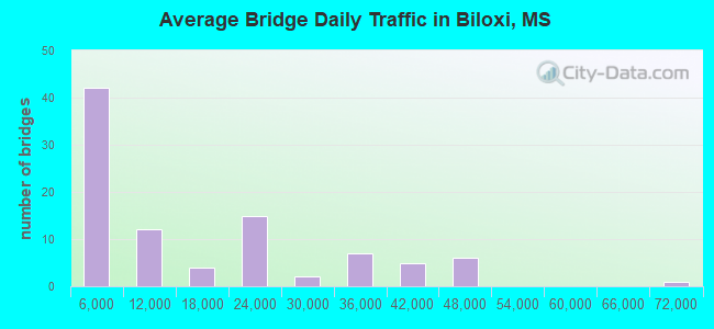
- 1,359,177Total average daily traffic
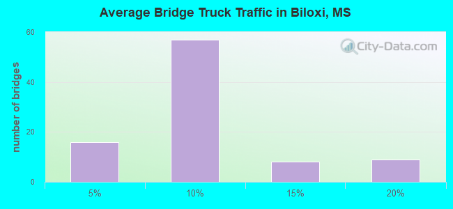
- 108,500Total average daily truck traffic
- National Bridge Inventory (NBI) Registered Bridges for Biloxi
- No street view available for this location
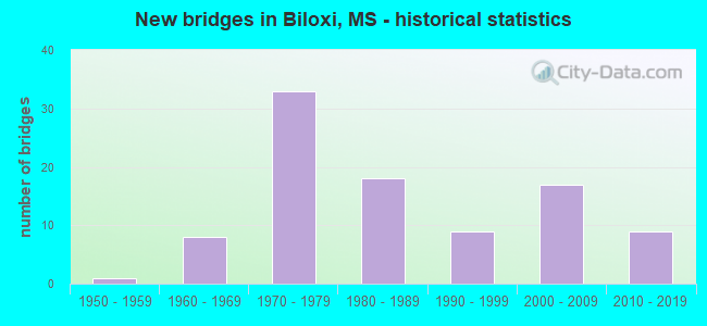
- New bridges - historical statistics
- 11950-1959
- 81960-1969
- 331970-1979
- 181980-1989
- 91990-1999
- 172000-2009
- 92010-2019
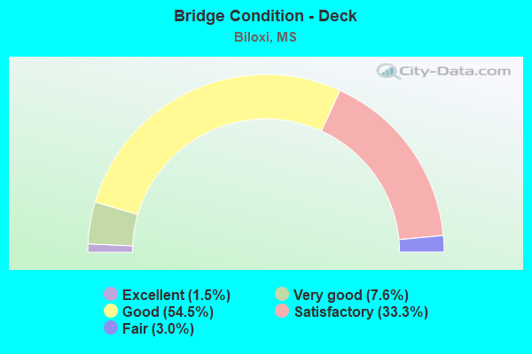
- Bridge Condition - Deck
- 1.5%Excellent
- 7.6%Very good
- 54.5%Good
- 33.3%Satisfactory
- 3.0%Fair
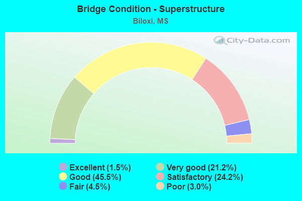
- Bridge Condition - Superstructure
- 1.5%Excellent
- 21.2%Very good
- 45.5%Good
- 24.2%Satisfactory
- 4.5%Fair
- 3.0%Poor
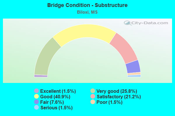
- Bridge Condition - Substructure
- 1.5%Excellent
- 25.8%Very good
- 40.9%Good
- 21.2%Satisfactory
- 7.6%Fair
- 1.5%Poor
- 1.5%Serious
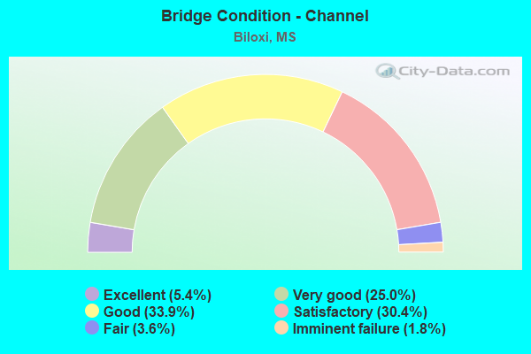
- Bridge Condition - Channel
- 5.4%Excellent
- 25.0%Very good
- 33.9%Good
- 30.4%Satisfactory
- 3.6%Fair
- 1.8%Imminent failure
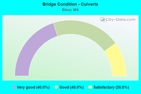
- Bridge Condition - Culverts
- 40.0%Very good
- 40.0%Good
- 20.0%Satisfactory
Find on map >> Show street view
Structure Number: SA2400000000048, Location: SEC 11 T 6S R10W B (Lat: 30.544722, Lng: -88.951389), Route carried "on" structure: County highway 1138, Year Built: 1969, Status: Open, Structure Length: 6.10m (20.01ft), Average Daily Traffic: 700 (year 2010), Truck Traffic: 8%, Average Future Daily Traffic: 1,300 (year 2030), Design Load: HS 15, Features Intersected: TUXACHANIE CREEK
Minimum Vertical Clearance: 30+ m (98+ ft), Kilometerpoint: 2.896, Lanes on structure: 2, Owner: County Highway Agency, Approaching Roadway Width: 8.8m (28.9ft), Material/Design: Prestressed concrete, Design/Construction: Stringer/Multi-beam, Number Of Spans In Main Unit: 4, Length of Maximum Span: 24.4m (80.1ft), Curb-To-Curb Width: 8.0m (26.2ft), Out-to-Out Width: 8.8m (28.9ft)
Condition: Deck: Satisfactory, Superstructure: Satisfactory, Substructure: Satisfactory, Channel: Satisfactory, Operating Rating: 50.0 metric tons, Method Used To Determine Operating Rating: Load Factor (LF), Inventory Rating: 28.1 metric tons, Method Used To Determine Inventory Rating: Load Factor (LF), Structural Evaluation: Equal to present minimum criteria, Deck Geometry: Somewhat better than minimum adequacy, Waterway Adequacy: Superior to present desirable criteria, Approach Roadway Alignment: Equal to present minimum criteria, Designated Inspection Frequency: Every 24 months, Inspection Date: Febuary 2021, Deck Structure Type: Concrete Cast-file-Place, Wearing Surface/Protective System: Wearing Surface: Monolithic Concrete
Find on map >> Show street view
Structure Number: SA2400000000049, Location: SEC 19 T 6S R10W B (Lat: 30.500833, Lng: -89.025556), Route carried "on" structure: County highway 1144, Year Built: 1983, Status: Open, Structure Length: 1.22m (4.00ft), Average Daily Traffic: 1,200 (year 2009), Truck Traffic: 8%, Average Future Daily Traffic: 1,800 (year 2030), Design Load: HS 20, Features Intersected: MILL CREEK
Minimum Vertical Clearance: 30+ m (98+ ft), Kilometerpoint: 6.598, Lanes on structure: 2, Owner: County Highway Agency, Approaching Roadway Width: 11.0m (36.1ft), Skew: 3 degrees, Material/Design: Concrete, Design/Construction: Culvert, Number Of Spans In Main Unit: 2, Length of Maximum Span: 6.1m (20.0ft)
Condition: Channel: Very good, Culverts: Satisfactory, Operating Rating: 43.2 metric tons, Method Used To Determine Operating Rating: Allowable Stress (AS), Inventory Rating: 32.4 metric tons, Method Used To Determine Inventory Rating: Allowable Stress (AS), Structural Evaluation: Equal to present minimum criteria, Waterway Adequacy: Better than present minimum criteria, Approach Roadway Alignment: Equal to present desirable criteria, Designated Inspection Frequency: Every 24 months, Inspection Date: May 2021
Find on map >> Show street view
Structure Number: SA240000000005, Location: SEC 30 T 6S R10W B (Lat: 30.491667, Lng: -89.033333), Route carried "on" structure: County highway 1144, Year Built: 1983, Status: Open, Structure Length: 7.32m (24.02ft), Average Daily Traffic: 1,500 (year 2009), Truck Traffic: 8%, Average Future Daily Traffic: 2,500 (year 2030), Design Load: HS 20, Features Intersected: MILL CREEK
Minimum Vertical Clearance: 30+ m (98+ ft), Kilometerpoint: 5.310, Lanes on structure: 2, Owner: County Highway Agency, Approaching Roadway Width: 13.7m (44.9ft), Material/Design: Prestressed concrete, Design/Construction: Stringer/Multi-beam, Number Of Spans In Main Unit: 6, Length of Maximum Span: 12.2m (40.0ft), Curb-To-Curb Width: 8.5m (27.9ft), Out-to-Out Width: 9.4m (30.8ft)
Condition: Deck: Good, Superstructure: Good, Substructure: Good, Channel: Good, Operating Rating: 62.1 metric tons, Method Used To Determine Operating Rating: Load Factor (LF), Inventory Rating: 37.6 metric tons, Method Used To Determine Inventory Rating: Load Factor (LF), Structural Evaluation: Better than present minimum criteria, Deck Geometry: Somewhat better than minimum adequacy, Waterway Adequacy: Superior to present desirable criteria, Approach Roadway Alignment: Equal to present desirable criteria, Designated Inspection Frequency: Every 24 months, Inspection Date: November 2020, Bridge Improvement Cost: $2,000, Roadway Improvement Cost: $1,000, Total Project Cost: $3,000 ( Estimate for 2018), Deck Structure Type: Concrete Cast-file-Place, Wearing Surface/Protective System: Wearing Surface: Monolithic Concrete
Find on map >> Show street view
Structure Number: SA2400000000051, Location: SEC 32 T 6S R10W (Lat: 30.476111, Lng: -89.001667), Route carried "on" structure: City street 557, Year Built: 2011, Status: Open, Structure Length: 2.82m (9.25ft), Average Daily Traffic: 800 (year 2010), Truck Traffic: 8%, Average Future Daily Traffic: 1,200 (year 2030), Design Load: HL 93, Features Intersected: MILL CREEK, Facility Carried by Structure: JOHN LEE ROAD
Minimum Vertical Clearance: 30+ m (98+ ft), Kilometerpoint: 0.804, Lanes on structure: 2, Owner: County Highway Agency, Approaching Roadway Width: 7.6m (24.9ft), Material/Design: Concrete, Design/Construction: Channel Beam, Number Of Spans In Main Unit: 3, Length of Maximum Span: 9.4m (30.8ft), Curb or Sidewalk Widths: Left: 0.3m (1.0ft), Right: 0.3m (1.0ft), Curb-To-Curb Width: 8.8m (28.9ft), Out-to-Out Width: 9.4m (30.8ft)
Condition: Deck: Good, Superstructure: Good, Substructure: Good, Channel: Excellent, Operating Rating: 43.7 metric tons, Method Used To Determine Operating Rating: Load and Resistance Factor Rating (LRFR) rating reported by rating factor(RF) method using HL-93 loadings, Inventory Rating: 33.7 metric tons, Method Used To Determine Inventory Rating: Load and Resistance Factor Rating (LRFR) rating reported by rating factor(RF) method using HL-93 loadings, Structural Evaluation: Better than present minimum criteria, Deck Geometry: Somewhat better than minimum adequacy, Waterway Adequacy: Equal to present desirable criteria, Approach Roadway Alignment: Better than present minimum criteria, Length Of Structure Improvement: 2.60m (8.53ft), Designated Inspection Frequency: Every 24 months, Inspection Date: May 2021, Bridge Improvement Cost: $1,000, Roadway Improvement Cost: $1,000, Total Project Cost: $2,000, Deck Structure Type: Concrete Precast Panels, Wearing Surface/Protective System: Wearing Surface: Monolithic Concrete
Find on map >> Show street view
Structure Number: SA2400000000052, Location: SEC 33 T 6S R10W (Lat: 30.478633, Lng: -88.997506), Route carried "on" structure: County highway 550, Year Built: 1989, Status: Open, Structure Length: 1.16m (3.81ft), Average Daily Traffic: 600 (year 2020), Truck Traffic: 8%, Average Future Daily Traffic: 900 (year 2040), Design Load: HS 20, Features Intersected: MILL CREEK, Facility Carried by Structure: WASH FAYARD ROAD
Minimum Vertical Clearance: 30+ m (98+ ft), Kilometerpoint: 0.482, Lanes on structure: 2, Owner: City or Municipal Highway Agency, Approaching Roadway Width: 5.5m (18.0ft), Skew: 3 degrees, Material/Design: Concrete, Design/Construction: Channel Beam, Number Of Spans In Main Unit: 2, Length of Maximum Span: 5.8m (19.0ft), Curb or Sidewalk Widths: Left: 0.2m (0.7ft), Right: 0.2m (0.7ft), Curb-To-Curb Width: 7.1m (23.3ft), Out-to-Out Width: 7.5m (24.6ft)
Condition: Deck: Satisfactory, Superstructure: Satisfactory, Substructure: Good, Channel: Fair, Operating Rating: 71.9 metric tons, Method Used To Determine Operating Rating: Load Factor (LF), Inventory Rating: 43.0 metric tons, Method Used To Determine Inventory Rating: Load Factor (LF), Structural Evaluation: Equal to present minimum criteria, Deck Geometry: Meets minimum limits, Waterway Adequacy: Equal to present desirable criteria, Approach Roadway Alignment: Equal to present minimum criteria, Length Of Structure Improvement: 1.16m (3.81ft), Designated Inspection Frequency: Every 24 months, Inspection Date: October 2020, Bridge Improvement Cost: $3,000, Roadway Improvement Cost: $1,000, Total Project Cost: $4,000, Deck Structure Type: Concrete Precast Panels, Wearing Surface/Protective System: Wearing Surface: Monolithic Concrete
Find on map >> Show street view
Structure Number: SA2400000000053, Location: SEC 35 T 6S R10W B (Lat: 30.472058, Lng: -88.962586), Route carried "on" structure: County highway 530, Year Built: 1964, Status: Open, Structure Length: 2.90m (9.51ft), Average Daily Traffic: 4,000 (year 2021), Truck Traffic: 8%, Average Future Daily Traffic: 6,000 (year 2041), Design Load: H 15, Features Intersected: PARKER CREEK, Facility Carried by Structure: WOOLMARKET RD
Minimum Vertical Clearance: 30+ m (98+ ft), Kilometerpoint: 3.218, Lanes on structure: 2, Owner: City or Municipal Highway Agency, Approaching Roadway Width: 6.8m (22.3ft), Material/Design: Concrete, Design/Construction: Channel Beam, Number Of Spans In Main Unit: 5, Length of Maximum Span: 5.8m (19.0ft), Curb or Sidewalk Widths: Left: 0.2m (0.7ft), Right: 0.2m (0.7ft), Curb-To-Curb Width: 8.2m (26.9ft), Out-to-Out Width: 8.6m (28.2ft)
Condition: Deck: Satisfactory, Superstructure: Satisfactory, Substructure: Satisfactory, Channel: Satisfactory, Operating Rating: 54.6 metric tons, Method Used To Determine Operating Rating: Load Factor (LF), Inventory Rating: 32.7 metric tons, Method Used To Determine Inventory Rating: Load Factor (LF), Structural Evaluation: Equal to present minimum criteria, Deck Geometry: High priority of corrective action, Waterway Adequacy: Equal to present desirable criteria, Approach Roadway Alignment: Equal to present desirable criteria, Length Of Structure Improvement: 2.90m (9.51ft), Designated Inspection Frequency: Every 12 months, Inspection Date: October 2021, Bridge Improvement Cost: $30,000, Roadway Improvement Cost: $1,000, Total Project Cost: $31,000, Deck Structure Type: Concrete Precast Panels, Wearing Surface/Protective System: Wearing Surface: Bituminous
Find on map >> Show street view
Structure Number: SA2400000000055, Location: SEC 13 T 6S R11W B (Lat: 30.529619, Lng: -89.043350), Route carried "on" structure: County highway 8136, Year Built: 1979, Status: Open, Structure Length: 1.83m (6.00ft), Average Daily Traffic: 1,200 (year 2020), Truck Traffic: 3%, Average Future Daily Traffic: 1,800 (year 2040), Design Load: H 15, Features Intersected: WALKER CREEK, Facility Carried by Structure: WHITE STAR ROAD
Minimum Vertical Clearance: 30+ m (98+ ft), Kilometerpoint: 2.253, Lanes on structure: 2, Owner: County Highway Agency, Approaching Roadway Width: 9.1m (29.9ft), Material/Design: Steel, Number Of Spans In Main Unit: 1, Length of Maximum Span: 18.3m (60.0ft), Curb-To-Curb Width: 6.6m (21.7ft), Out-to-Out Width: 6.9m (22.6ft)
Condition: Deck: Satisfactory, Superstructure: Poor, Substructure: Satisfactory, Channel: Good, Operating Rating: 39.8 metric tons, Method Used To Determine Operating Rating: Load Factor (LF), Inventory Rating: 23.8 metric tons, Method Used To Determine Inventory Rating: Load Factor (LF), Structural Evaluation: Meets minimum limits, Deck Geometry: High priority of replacement, Waterway Adequacy: Equal to present desirable criteria, Approach Roadway Alignment: Equal to present desirable criteria, Length Of Structure Improvement: 1.83m (6.00ft), Designated Inspection Frequency: Every 12 months, Inspection Date: December 2020, Bridge Improvement Cost: $15,000, Roadway Improvement Cost: $1,000, Total Project Cost: $16,000, Deck Structure Type: Open Grating, Wearing Surface/Protective System: Wearing Surface: Other
Find on map >> Show street view
Structure Number: SA2400000000058, Location: SEC 25 T 6S R11W B (Lat: 30.488475, Lng: -89.035583), Route carried "on" structure: County highway 1144, Year Built: 1983, Status: Open, Structure Length: 10.70m (35.10ft), Average Daily Traffic: 4,167 (year 2021), Truck Traffic: 8%, Average Future Daily Traffic: 4,584 (year 2041), Design Load: HS 20, Features Intersected: BILOXI RIVER
Minimum Vertical Clearance: 30+ m (98+ ft), Kilometerpoint: 4.828, Lanes on structure: 2, Owner: City or Municipal Highway Agency, Approaching Roadway Width: 13.7m (44.9ft), Material/Design: Steel continuous, Design/Construction: Stringer/Multi-beam, Number Of Spans In Main Unit: 3, Length of Maximum Span: 41.5m (136.2ft), Curb-To-Curb Width: 8.5m (27.9ft), Out-to-Out Width: 9.4m (30.8ft)
Condition: Deck: Satisfactory, Superstructure: Satisfactory, Substructure: Good, Channel: Satisfactory, Operating Rating: 45.0 metric tons, Method Used To Determine Operating Rating: Load Factor (LF) rating reported by rating factor (RF) method using MS18 loading, Inventory Rating: 26.9 metric tons, Method Used To Determine Inventory Rating: Load Factor (LF) rating reported by rating factor (RF) method using MS18 loading, Structural Evaluation: Equal to present minimum criteria, Deck Geometry: Meets minimum limits, Waterway Adequacy: Equal to present desirable criteria, Approach Roadway Alignment: Equal to present minimum criteria, Designated Inspection Frequency: Every 24 months, Inspection Date: November 2021, Deck Structure Type: Concrete Cast-file-Place, Wearing Surface/Protective System: Wearing Surface: Monolithic Concrete
Find on map >> Show street view
Structure Number: SA2400000000078, Location: SEC 26 T 7S R 9W (Lat: 30.403494, Lng: -88.899964), Route carried "on" structure: City street 46, Year Built: 1990, Status: Open, Structure Length: 0.94m (3.08ft), Average Daily Traffic: 3,000 (year 2010), Truck Traffic: 8%, Average Future Daily Traffic: 5,000 (year 2030), Design Load: HS 20, Features Intersected: KEEGANS BAYOU, Facility Carried by Structure: DIVISION ST
Minimum Vertical Clearance: 30+ m (98+ ft), Kilometerpoint: 0.321, Lanes on structure: 4, Owner: City or Municipal Highway Agency, Approaching Roadway Width: 15.2m (49.9ft), Material/Design: Concrete, Design/Construction: Channel Beam, Number Of Spans In Main Unit: 1, Length of Maximum Span: 9.4m (30.8ft), Curb or Sidewalk Widths: Left: 1.5m (4.9ft), Right: 1.5m (4.9ft), Curb-To-Curb Width: 15.2m (49.9ft), Out-to-Out Width: 18.3m (60.0ft)
Condition: Deck: Good, Superstructure: Good, Substructure: Good, Channel: Satisfactory, Operating Rating: 52.6 metric tons, Method Used To Determine Operating Rating: Load Factor (LF), Inventory Rating: 31.4 metric tons, Method Used To Determine Inventory Rating: Load Factor (LF), Structural Evaluation: Better than present minimum criteria, Deck Geometry: High priority of corrective action, Waterway Adequacy: Equal to present desirable criteria, Approach Roadway Alignment: Equal to present desirable criteria, Designated Inspection Frequency: Every 24 months, Inspection Date: May 2021, Deck Structure Type: Concrete Precast Panels, Wearing Surface/Protective System: Wearing Surface: Monolithic Concrete
Find on map >> Show street view
Structure Number: SA2400000000079, Location: SEC 26 T 7S R 9W (Lat: 30.405556, Lng: -88.895278), Route carried "on" structure: City street 149, Year Built: 2000, Status: Open, Structure Length: 2.85m (9.35ft), Average Daily Traffic: 20 (year 2012), Average Future Daily Traffic: 50 (year 2032), Design Load: HS 20, Features Intersected: KEEGANS BAYOU, Facility Carried by Structure: HOPKINS BLVD
Minimum Vertical Clearance: 30+ m (98+ ft), Kilometerpoint: 1.126, Lanes on structure: 2, Owner: City or Municipal Highway Agency, Approaching Roadway Width: 12.8m (42.0ft), Material/Design: Concrete, Design/Construction: Channel Beam, Number Of Spans In Main Unit: 3, Length of Maximum Span: 9.5m (31.2ft), Curb or Sidewalk Widths: Left: 0.2m (0.7ft), Right: 1.1m (3.6ft), Curb-To-Curb Width: 8.6m (28.2ft), Out-to-Out Width: 9.9m (32.5ft)
Condition: Deck: Good, Superstructure: Good, Substructure: Good, Channel: Very good, Operating Rating: 89.2 metric tons, Method Used To Determine Operating Rating: Load Factor (LF), Inventory Rating: 53.6 metric tons, Method Used To Determine Inventory Rating: Load Factor (LF), Structural Evaluation: Better than present minimum criteria, Deck Geometry: Better than present minimum criteria, Waterway Adequacy: Superior to present desirable criteria, Approach Roadway Alignment: Better than present minimum criteria, Designated Inspection Frequency: Every 24 months, Inspection Date: October 2021, Deck Structure Type: Concrete Precast Panels
Find on map >> Show street view
Structure Number: SA240000000008, Location: SEC 26 T 7S R 9W (Lat: 30.403283, Lng: -88.900139), Route carried "on" structure: City street 167, Year Built: 1993, Status: Open, Structure Length: 1.16m (3.81ft), Average Daily Traffic: 1,000 (year 2010), Truck Traffic: 8%, Average Future Daily Traffic: 1,500 (year 2030), Design Load: HS 20, Features Intersected: KEEGANS BAYOU, Facility Carried by Structure: BENACHI AVE
Minimum Vertical Clearance: 30+ m (98+ ft), Kilometerpoint: 0.643, Lanes on structure: 2, Owner: City or Municipal Highway Agency, Approaching Roadway Width: 7.0m (23.0ft), Material/Design: Concrete, Design/Construction: Channel Beam, Number Of Spans In Main Unit: 2, Length of Maximum Span: 5.8m (19.0ft), Curb or Sidewalk Widths: Left: 1.1m (3.6ft), Right: 1.1m (3.6ft), Curb-To-Curb Width: 7.2m (23.6ft), Out-to-Out Width: 10.5m (34.4ft)
Condition: Deck: Satisfactory, Superstructure: Good, Substructure: Good, Channel: Good, Operating Rating: 53.9 metric tons, Method Used To Determine Operating Rating: Load Factor (LF), Inventory Rating: 32.4 metric tons, Method Used To Determine Inventory Rating: Load Factor (LF), Structural Evaluation: Better than present minimum criteria, Deck Geometry: Meets minimum limits, Waterway Adequacy: Equal to present desirable criteria, Approach Roadway Alignment: Equal to present minimum criteria, Length Of Structure Improvement: 1.16m (3.81ft), Designated Inspection Frequency: Every 24 months, Inspection Date: May 2021, Bridge Improvement Cost: $3,000, Roadway Improvement Cost: $1,000, Total Project Cost: $4,000, Deck Structure Type: Concrete Precast Panels, Wearing Surface/Protective System: Wearing Surface: Monolithic Concrete
Find on map >> Show street view
Structure Number: SA2400000000081, Location: SEC 26 T 7S R 9W (Lat: 30.403006, Lng: -88.901986), Route carried "on" structure: City street 169, Year Built: 1950, Status: Posted for load, Structure Length: 0.70m (2.30ft), Average Daily Traffic: 4,500 (year 2021), Truck Traffic: 2%, Average Future Daily Traffic: 6,720 (year 2041), Features Intersected: KEEGANS BAYOU, Facility Carried by Structure: PORTER AVE
Minimum Vertical Clearance: 30+ m (98+ ft), Kilometerpoint: 0.965, Lanes on structure: 2, Owner: City or Municipal Highway Agency, Approaching Roadway Width: 8.4m (27.6ft), Material/Design: Concrete continuous, Design/Construction: Slab, Number Of Spans In Main Unit: 2, Length of Maximum Span: 3.5m (11.5ft), Curb or Sidewalk Widths: Left: 1.7m (5.6ft), Right: 1.7m (5.6ft), Curb-To-Curb Width: 8.4m (27.6ft), Out-to-Out Width: 11.8m (38.7ft)
Condition: Deck: Satisfactory, Superstructure: Satisfactory, Substructure: Poor, Channel: Good, Operating Rating: 3.6 metric tons, Method Used To Determine Operating Rating: Field evaluation and documented engineering judgment, Inventory Rating: 2.2 metric tons, Method Used To Determine Inventory Rating: Field evaluation and documented engineering judgment, Structural Evaluation: High priority of replacement, Deck Geometry: High priority of corrective action, Waterway Adequacy: Equal to present desirable criteria, Approach Roadway Alignment: Equal to present desirable criteria, Bridge Posting: Required (Relationship of Operating Rating to Maximum Legal Load: > 39.9% below), Length Of Structure Improvement: 1.05m (3.44ft), Designated Inspection Frequency: Every 12 months, Inspection Date: November 2021, Bridge Improvement Cost: $150,000, Roadway Improvement Cost: $75,000, Total Project Cost: $300,000, Deck Structure Type: Concrete Cast-file-Place, Wearing Surface/Protective System: Wearing Surface: Bituminous
Find on map >> Show street view
Structure Number: SA2400000000082, Location: SEC 26 T 7S R 9W (Lat: 30.403056, Lng: -88.901111), Route carried "on" structure: City street 171, Year Built: 1994, Status: Open, Structure Length: 0.94m (3.08ft), Average Daily Traffic: 900 (year 2011), Truck Traffic: 8%, Average Future Daily Traffic: 1,350 (year 2032), Design Load: HS 20, Features Intersected: KEEGANS BAYOU, Facility Carried by Structure: QUERENS AVE
Minimum Vertical Clearance: 30+ m (98+ ft), Kilometerpoint: 0.643, Lanes on structure: 2, Owner: City or Municipal Highway Agency, Approaching Roadway Width: 7.0m (23.0ft), Material/Design: Concrete, Design/Construction: Channel Beam, Number Of Spans In Main Unit: 1, Length of Maximum Span: 9.4m (30.8ft), Curb or Sidewalk Widths: Left: 1.4m (4.6ft), Right: 1.4m (4.6ft), Curb-To-Curb Width: 7.2m (23.6ft), Out-to-Out Width: 10.0m (32.8ft)
Condition: Deck: Satisfactory, Superstructure: Good, Substructure: Satisfactory, Channel: Good, Operating Rating: 60.3 metric tons, Method Used To Determine Operating Rating: Load Factor (LF), Inventory Rating: 36.1 metric tons, Method Used To Determine Inventory Rating: Load Factor (LF), Structural Evaluation: Equal to present minimum criteria, Deck Geometry: Meets minimum limits, Waterway Adequacy: Equal to present desirable criteria, Approach Roadway Alignment: Equal to present minimum criteria, Designated Inspection Frequency: Every 24 months, Inspection Date: October 2021, Deck Structure Type: Concrete Precast Panels
Find on map >> Show street view
Structure Number: SA2400000000083, Location: SEC 26 T 7S R 9W (Lat: 30.402500, Lng: -88.903611), Route carried "on" structure: City street 177, Year Built: 1990, Status: Open, Structure Length: 1.16m (3.81ft), Average Daily Traffic: 4,500 (year 2011), Truck Traffic: 8%, Average Future Daily Traffic: 6,600 (year 2032), Design Load: HS 20+Mod, Features Intersected: KEEGANS BAYOU, Facility Carried by Structure: FOREST AVE
Minimum Vertical Clearance: 30+ m (98+ ft), Kilometerpoint: 0.321, Lanes on structure: 2, Owner: City or Municipal Highway Agency, Approaching Roadway Width: 8.5m (27.9ft), Material/Design: Concrete, Design/Construction: Channel Beam, Number Of Spans In Main Unit: 2, Length of Maximum Span: 5.8m (19.0ft), Curb or Sidewalk Widths: Left: 2.4m (7.9ft), Right: 2.4m (7.9ft), Curb-To-Curb Width: 8.5m (27.9ft), Out-to-Out Width: 14.0m (45.9ft)
Condition: Deck: Satisfactory, Superstructure: Good, Substructure: Good, Channel: Good, Operating Rating: 60.1 metric tons, Method Used To Determine Operating Rating: Load Factor (LF), Inventory Rating: 36.0 metric tons, Method Used To Determine Inventory Rating: Load Factor (LF), Structural Evaluation: Better than present minimum criteria, Deck Geometry: Meets minimum limits, Waterway Adequacy: Equal to present desirable criteria, Approach Roadway Alignment: Equal to present desirable criteria, Designated Inspection Frequency: Every 24 months, Inspection Date: October 2021, Deck Structure Type: Concrete Precast Panels
Find on map >> Show street view
Structure Number: SA2400000000085, Location: SEC 33 T 7S R 9W (Lat: 30.408686, Lng: -88.877703), Route carried "on" structure: City street 25, Year Built: 1987, Status: Closed, Structure Length: 0.94m (3.08ft), Average Future Daily Traffic: 1 (year 2038), Design Load: H 15, Features Intersected: BAY BAYOU, Facility Carried by Structure: BOWEN ST
Minimum Vertical Clearance: 30+ m (98+ ft), Kilometerpoint: 1.770, Lanes on structure: 2, Owner: City or Municipal Highway Agency, Approaching Roadway Width: 8.8m (28.9ft), Material/Design: Concrete, Design/Construction: Channel Beam, Number Of Spans In Main Unit: 1, Length of Maximum Span: 9.4m (30.8ft), Curb-To-Curb Width: 8.3m (27.2ft), Out-to-Out Width: 8.7m (28.5ft)
Condition: Deck: Satisfactory, Superstructure: Satisfactory, Substructure: Serious, Channel: Imminent failure, Deck Geometry: Equal to present minimum criteria, Bridge Posting: Required (Relationship of Operating Rating to Maximum Legal Load: > 39.9% below), Length Of Structure Improvement: 1.50m (4.92ft), Designated Inspection Frequency: Every 12 months, Inspection Date: October 2021, Bridge Improvement Cost: $250,000, Roadway Improvement Cost: $30,000, Total Project Cost: $325,000, Deck Structure Type: Concrete Precast Panels
Find on map >> Show street view
Structure Number: SA2400000000087, Location: SEC 1 T 7S R10W B (Lat: 30.468753, Lng: -88.938903), Route carried "on" structure: County highway 67, Year Built: 1960, Status: Posted for load, Structure Length: 2.68m (8.79ft), Average Daily Traffic: 5,000 (year 2020), Truck Traffic: 8%, Average Future Daily Traffic: 7,500 (year 2040), Design Load: H 15, Features Intersected: HOWARD CREEK
Minimum Vertical Clearance: 30+ m (98+ ft), Kilometerpoint: 3.379, Lanes on structure: 2, Owner: City or Municipal Highway Agency, Approaching Roadway Width: 10.1m (33.1ft), Material/Design: Steel, Design/Construction: Stringer/Multi-beam, Number Of Spans In Main Unit: 3, Length of Maximum Span: 12.2m (40.0ft), Curb or Sidewalk Widths: Left: 0.3m (1.0ft), Right: 0.3m (1.0ft), Curb-To-Curb Width: 6.7m (22.0ft), Out-to-Out Width: 7.4m (24.3ft)
Condition: Deck: Fair, Superstructure: Fair, Substructure: Satisfactory, Channel: Satisfactory, Operating Rating: 30.7 metric tons, Method Used To Determine Operating Rating: Load Factor (LF), Inventory Rating: 18.4 metric tons, Method Used To Determine Inventory Rating: Load Factor (LF), Structural Evaluation: Somewhat better than minimum adequacy, Deck Geometry: High priority of replacement, Waterway Adequacy: Equal to present desirable criteria, Approach Roadway Alignment: Equal to present desirable criteria, Bridge Posting: Required (Relationship of Operating Rating to Maximum Legal Load: 20.0 - 29.9% below), Length Of Structure Improvement: 2.68m (8.79ft), Designated Inspection Frequency: Every 24 months, Inspection Date: November 2020, Bridge Improvement Cost: $45,000, Roadway Improvement Cost: $1,000, Total Project Cost: $46,000, Deck Structure Type: Concrete Cast-file-Place, Wearing Surface/Protective System: Wearing Surface: Monolithic Concrete
Find on map >> Show street view
Structure Number: SA2400000000088, Location: SEC 1 T 7S R10W B (Lat: 30.459769, Lng: -88.938958), Route carried "on" structure: County highway 439, Year Built: 1973, Status: Posted for load, Structure Length: 14.54m (47.70ft), Average Daily Traffic: 6,000 (year 2020), Truck Traffic: 8%, Average Future Daily Traffic: 9,000 (year 2040), Design Load: H 15, Features Intersected: TCHOUTACABOUFFA RIVER, Facility Carried by Structure: CEDAR LAKE RD
Minimum Vertical Clearance: 30+ m (98+ ft), Kilometerpoint: 0.965, Lanes on structure: 2, Owner: City or Municipal Highway Agency, Approaching Roadway Width: 7.9m (25.9ft), Navigation Control: Yes ( Vertical Clearance: 3.0m (9.8ft), Horizontal Clearance: 21.6m (70.9ft)), Material/Design: Steel, Design/Construction: Movable - Swing, Number Of Spans In Main Unit: 2, Number Of Approach Spans: 10, Length of Maximum Span: 55.5m (182.1ft), Curb or Sidewalk Widths: Left: 0.3m (1.0ft), Right: 0.3m (1.0ft), Curb-To-Curb Width: 7.9m (25.9ft), Out-to-Out Width: 8.5m (27.9ft)
Condition: Deck: Satisfactory, Superstructure: Poor, Substructure: Satisfactory, Channel: Satisfactory, Operating Rating: 22.2 metric tons, Method Used To Determine Operating Rating: Load Factor (LF), Inventory Rating: 13.3 metric tons, Method Used To Determine Inventory Rating: Load Factor (LF), Structural Evaluation: High priority of corrective action, Deck Geometry: High priority of corrective action, Waterway Adequacy: Equal to present minimum criteria, Approach Roadway Alignment: Equal to present minimum criteria, Bridge Posting: Required (Relationship of Operating Rating to Maximum Legal Load: > 39.9% below), Length Of Structure Improvement: 14.48m (47.51ft), Designated Inspection Frequency: Every 24 months, Critical Feature Inspection Frequency: Every 12 months, Underwater Inspection Frequency: Every 60 months, Inspection Date: December 2019, Critical Feature Inspection Date: December 2020, Underwater Inspection Date: September 2020, Bridge Improvement Cost: $100,000, Roadway Improvement Cost: $1,000, Total Project Cost: $130,000, Deck Structure Type: Concrete Cast-file-Place, Wearing Surface/Protective System: Wearing Surface: Monolithic Concrete
Find on map >> Show street view
Structure Number: SA2400000000089, Location: SEC 2 T 7S R10W (Lat: 30.460000, Lng: -88.965278), Route carried "on" structure: County highway 532, Year Built: 1970, Status: Open, Structure Length: 7.32m (24.02ft), Average Daily Traffic: 600 (year 2011), Truck Traffic: 8%, Average Future Daily Traffic: 900 (year 2032), Design Load: HS 20, Features Intersected: PARKERS CREEK, Facility Carried by Structure: OAKLAWN RD EAST
Minimum Vertical Clearance: 30+ m (98+ ft), Kilometerpoint: 0.804, Lanes on structure: 2, Owner: City or Municipal Highway Agency, Approaching Roadway Width: 11.3m (37.1ft), Material/Design: Prestressed concrete, Design/Construction: Stringer/Multi-beam, Number Of Spans In Main Unit: 6, Length of Maximum Span: 12.2m (40.0ft), Curb-To-Curb Width: 8.1m (26.6ft), Out-to-Out Width: 9.1m (29.9ft)
Condition: Deck: Satisfactory, Superstructure: Very good, Substructure: Satisfactory, Channel: Satisfactory, Operating Rating: 60.8 metric tons, Method Used To Determine Operating Rating: Load Factor (LF), Inventory Rating: 27.5 metric tons, Method Used To Determine Inventory Rating: Load Factor (LF), Structural Evaluation: Equal to present minimum criteria, Deck Geometry: Somewhat better than minimum adequacy, Waterway Adequacy: Better than present minimum criteria, Approach Roadway Alignment: Equal to present minimum criteria, Length Of Structure Improvement: 0.10m (0.33ft), Designated Inspection Frequency: Every 24 months, Inspection Date: March 2021, Bridge Improvement Cost: $1,000, Roadway Improvement Cost: $1,000, Total Project Cost: $2,000, Deck Structure Type: Concrete Cast-file-Place, Wearing Surface/Protective System: Wearing Surface: Monolithic Concrete
Find on map >> Show street view
Structure Number: SA2400000000093, Location: SEC 22 T 7S R10W (Lat: 30.424444, Lng: -88.978333), Route carried "on" structure: City street 560, Year Built: 1997, Status: Open, Structure Length: 5.70m (18.70ft), Average Daily Traffic: 300 (year 2010), Truck Traffic: 3%, Average Future Daily Traffic: 500 (year 2030), Design Load: HS 20, Features Intersected: BILOXI BAY, Facility Carried by Structure: OLD POPPS FERRY RD
Minimum Vertical Clearance: 30+ m (98+ ft), Kilometerpoint: 0.643, Lanes on structure: 2, Owner: City or Municipal Highway Agency, Approaching Roadway Width: 10.4m (34.1ft), Material/Design: Concrete, Design/Construction: Channel Beam, Number Of Spans In Main Unit: 6, Length of Maximum Span: 9.5m (31.2ft), Curb-To-Curb Width: 7.3m (24.0ft), Out-to-Out Width: 7.8m (25.6ft)
Condition: Deck: Satisfactory, Superstructure: Satisfactory, Substructure: Satisfactory, Channel: Good, Operating Rating: 75.5 metric tons, Method Used To Determine Operating Rating: Load Factor (LF), Inventory Rating: 45.4 metric tons, Method Used To Determine Inventory Rating: Load Factor (LF), Structural Evaluation: Equal to present minimum criteria, Deck Geometry: Somewhat better than minimum adequacy, Waterway Adequacy: Equal to present desirable criteria, Approach Roadway Alignment: Better than present minimum criteria, Length Of Structure Improvement: 5.70m (18.70ft), Designated Inspection Frequency: Every 24 months, Inspection Date: May 2021, Bridge Improvement Cost: $1,000, Roadway Improvement Cost: $2,000, Total Project Cost: $3,000, Deck Structure Type: Concrete Precast Panels, Wearing Surface/Protective System: Wearing Surface: Monolithic Concrete
Find on map >> Show street view
Structure Number: SA2400000000094, Location: SEC 22 T 7S R10W B (Lat: 30.415800, Lng: -88.975503), Route carried "on" structure: City street 560, Year Built: 1979, Status: Open, Structure Length: 121.43m (398.39ft), Average Daily Traffic: 20,000 (year 2019), Truck Traffic: 8%, Average Future Daily Traffic: 22,000 (year 2039), Design Load: HS 20+Mod, Features Intersected: BACK BAY BILOXI, Facility Carried by Structure: POPPS FERRY ROAD
Minimum Vertical Clearance: 30+ m (98+ ft), Kilometerpoint: 1.448, Lanes on structure: 2, Owner: City or Municipal Highway Agency, Approaching Roadway Width: 12.2m (40.0ft), Navigation Control: Yes ( Vertical Clearance: 9.7m (31.8ft), Horizontal Clearance: 52.4m (171.9ft)), Material/Design: Steel, Design/Construction: Movable - Bascule, Number Of Spans In Main Unit: 1, Number Of Approach Spans: 69, Length of Maximum Span: 38.1m (125.0ft), Curb or Sidewalk Widths: Left: 0.0m, Right: 2.1m (6.9ft), Curb-To-Curb Width: 9.6m (31.5ft), Out-to-Out Width: 12.0m (39.4ft)
Condition: Deck: Satisfactory, Superstructure: Fair, Substructure: Satisfactory, Channel: Good, Operating Rating: 35.5 metric tons, Method Used To Determine Operating Rating: Load Factor (LF), Inventory Rating: 21.2 metric tons, Method Used To Determine Inventory Rating: Load Factor (LF), Structural Evaluation: Somewhat better than minimum adequacy, Deck Geometry: Meets minimum limits, Waterway Adequacy: Better than present minimum criteria, Approach Roadway Alignment: Equal to present desirable criteria, Length Of Structure Improvement: 100.00m (328.08ft), Designated Inspection Frequency: Every 24 months, Critical Feature Inspection Frequency: Every 24 months, Underwater Inspection Frequency: Every 60 months, Inspection Date: December 2019, Critical Feature Inspection Date: December 2019, Underwater Inspection Date: September 2020, Bridge Improvement Cost: $500,000, Roadway Improvement Cost: $1,000, Total Project Cost: $575,000, Deck Structure Type: Concrete Cast-file-Place, Wearing Surface/Protective System: Wearing Surface: Monolithic Concrete
Find on map >> Show street view
Structure Number: SA2400000000177, Location: SEC 9 T 7S R10W (Lat: 30.457222, Lng: -88.988056), Route carried "on" structure: County highway 776, Year Built: 1996, Status: Open, Structure Length: 1.74m (5.71ft), Average Daily Traffic: 75 (year 2012), Average Future Daily Traffic: 125 (year 2032), Design Load: H 15, Features Intersected: CREEK, Facility Carried by Structure: NORTH OAKLAWN RD
Minimum Vertical Clearance: 30+ m (98+ ft), Kilometerpoint: 0.320, Lanes on structure: 2, Owner: City or Municipal Highway Agency, Approaching Roadway Width: 8.8m (28.9ft), Material/Design: Concrete, Design/Construction: Channel Beam, Number Of Spans In Main Unit: 3, Length of Maximum Span: 5.8m (19.0ft), Curb-To-Curb Width: 7.2m (23.6ft), Out-to-Out Width: 7.5m (24.6ft)
Condition: Deck: Satisfactory, Superstructure: Good, Substructure: Satisfactory, Channel: Satisfactory, Operating Rating: 59.5 metric tons, Method Used To Determine Operating Rating: Load Factor (LF), Inventory Rating: 35.6 metric tons, Method Used To Determine Inventory Rating: Load Factor (LF), Structural Evaluation: Equal to present minimum criteria, Deck Geometry: Somewhat better than minimum adequacy, Waterway Adequacy: Superior to present desirable criteria, Approach Roadway Alignment: Equal to present desirable criteria, Length Of Structure Improvement: 1.74m (5.71ft), Designated Inspection Frequency: Every 24 months, Inspection Date: December 2021, Bridge Improvement Cost: $6,000, Roadway Improvement Cost: $1,000, Total Project Cost: $7,000, Deck Structure Type: Concrete Precast Panels
Find on map >> Show street view
Structure Number: SA2400000000182, Location: SEC 26 T 7S R10W (Lat: 30.410000, Lng: -88.954167), Route carried "on" structure: City street 1, Year Built: 2002, Status: Open, Structure Length: 0.95m (3.12ft), Average Daily Traffic: 500 (year 2012), Truck Traffic: 8%, Average Future Daily Traffic: 750 (year 2032), Design Load: HS 20, Features Intersected: BAYOU LA PORTE, Facility Carried by Structure: HILLER PARK DR
Minimum Vertical Clearance: 30+ m (98+ ft), Kilometerpoint: 0.810, Lanes on structure: 2, Owner: City or Municipal Highway Agency, Approaching Roadway Width: 10.1m (33.1ft), Material/Design: Concrete, Design/Construction: Channel Beam, Number Of Spans In Main Unit: 1, Length of Maximum Span: 9.5m (31.2ft), Curb or Sidewalk Widths: Left: 0.2m (0.7ft), Right: 0.2m (0.7ft), Curb-To-Curb Width: 8.1m (26.6ft), Out-to-Out Width: 8.5m (27.9ft)
Condition: Deck: Good, Superstructure: Very good, Substructure: Satisfactory, Channel: Very good, Operating Rating: 53.9 metric tons, Method Used To Determine Operating Rating: Load Factor (LF), Inventory Rating: 32.4 metric tons, Method Used To Determine Inventory Rating: Load Factor (LF), Structural Evaluation: Equal to present minimum criteria, Deck Geometry: Somewhat better than minimum adequacy, Waterway Adequacy: Superior to present desirable criteria, Approach Roadway Alignment: Better than present minimum criteria, Designated Inspection Frequency: Every 24 months, Inspection Date: November 2021, Deck Structure Type: Concrete Precast Panels
Find on map >> Show street view
Structure Number: SA2400000000183, Location: SEC 26 T 7S R 9W (Lat: 30.404444, Lng: -88.898333), Route carried "on" structure: City street 157, Year Built: 2002, Status: Open, Structure Length: 0.95m (3.12ft), Average Daily Traffic: 75 (year 2012), Average Future Daily Traffic: 125 (year 2032), Design Load: HS 20, Features Intersected: KEEGANS BAYOU, Facility Carried by Structure: IROQUIS ST
Minimum Vertical Clearance: 30+ m (98+ ft), Kilometerpoint: 0.320, Lanes on structure: 2, Owner: City or Municipal Highway Agency, Approaching Roadway Width: 10.0m (32.8ft), Skew: 3 degrees, Material/Design: Concrete, Design/Construction: Channel Beam, Number Of Spans In Main Unit: 1, Length of Maximum Span: 9.5m (31.2ft), Curb or Sidewalk Widths: Left: 0.2m (0.7ft), Right: 0.2m (0.7ft), Curb-To-Curb Width: 8.1m (26.6ft), Out-to-Out Width: 8.5m (27.9ft)
Condition: Deck: Good, Superstructure: Good, Substructure: Good, Channel: Satisfactory, Operating Rating: 75.5 metric tons, Method Used To Determine Operating Rating: Load Factor (LF), Inventory Rating: 45.4 metric tons, Method Used To Determine Inventory Rating: Load Factor (LF), Structural Evaluation: Better than present minimum criteria, Deck Geometry: Equal to present minimum criteria, Waterway Adequacy: Equal to present desirable criteria, Approach Roadway Alignment: Better than present minimum criteria, Designated Inspection Frequency: Every 24 months, Inspection Date: November 2021, Deck Structure Type: Concrete Precast Panels
Find on map >> Show street view
Structure Number: SA2400000000184, Location: SEC 33 T 7S R 9W (Lat: 30.408417, Lng: -88.878306), Route carried "on" structure: City street 25, Year Built: 2003, Status: Open, Structure Length: 1.22m (4.00ft), Average Daily Traffic: 2,000 (year 2012), Truck Traffic: 8%, Average Future Daily Traffic: 3,500 (year 2032), Design Load: HS 20, Features Intersected: AUGUSTE BAYOU, Facility Carried by Structure: BACK BAY BLVD
Minimum Vertical Clearance: 30+ m (98+ ft), Kilometerpoint: 1.600, Lanes on structure: 4, Owner: City or Municipal Highway Agency, Approaching Roadway Width: 16.4m (53.8ft), Skew: 20 degrees, Material/Design: Prestressed concrete, Design/Construction: Stringer/Multi-beam, Number Of Spans In Main Unit: 1, Length of Maximum Span: 12.2m (40.0ft), Curb or Sidewalk Widths: Left: 1.8m (5.9ft), Right: 1.8m (5.9ft), Curb-To-Curb Width: 16.4m (53.8ft), Out-to-Out Width: 23.5m (77.1ft)
Condition: Deck: Good, Superstructure: Good, Substructure: Very good, Channel: Excellent, Operating Rating: 61.4 metric tons, Method Used To Determine Operating Rating: Load Factor (LF), Inventory Rating: 32.4 metric tons, Method Used To Determine Inventory Rating: Load Factor (LF), Structural Evaluation: Better than present minimum criteria, Deck Geometry: Meets minimum limits, Waterway Adequacy: Superior to present desirable criteria, Approach Roadway Alignment: Equal to present desirable criteria, Designated Inspection Frequency: Every 24 months, Inspection Date: November 2021, Deck Structure Type: Concrete Cast-file-Place, Wearing Surface/Protective System: Wearing Surface: Monolithic Concrete
Find on map >> Show street view
Structure Number: SA2400000000185, Location: SEC 33 T 7S R 9W (Lat: 30.405917, Lng: -88.874667), Route carried "on" structure: City street 25, Year Built: 2003, Status: Open, Structure Length: 1.22m (4.00ft), Average Daily Traffic: 2,500 (year 2012), Truck Traffic: 8%, Average Future Daily Traffic: 3,500 (year 2032), Design Load: HS 20, Features Intersected: BAY BAYOU, Facility Carried by Structure: BACK BAY BLVD
Minimum Vertical Clearance: 30+ m (98+ ft), Kilometerpoint: 1.900, Lanes on structure: 4, Owner: City or Municipal Highway Agency, Approaching Roadway Width: 16.4m (53.8ft), Skew: 20 degrees, Material/Design: Prestressed concrete, Design/Construction: Stringer/Multi-beam, Number Of Spans In Main Unit: 1, Length of Maximum Span: 12.2m (40.0ft), Curb or Sidewalk Widths: Left: 1.8m (5.9ft), Right: 1.8m (5.9ft), Curb-To-Curb Width: 16.4m (53.8ft), Out-to-Out Width: 23.5m (77.1ft)
Condition: Deck: Satisfactory, Superstructure: Good, Substructure: Good, Channel: Very good, Operating Rating: 61.4 metric tons, Method Used To Determine Operating Rating: Load Factor (LF), Inventory Rating: 32.4 metric tons, Method Used To Determine Inventory Rating: Load Factor (LF), Structural Evaluation: Better than present minimum criteria, Deck Geometry: Meets minimum limits, Waterway Adequacy: Superior to present desirable criteria, Approach Roadway Alignment: Equal to present desirable criteria, Length Of Structure Improvement: 1.22m (4.00ft), Designated Inspection Frequency: Every 24 months, Inspection Date: November 2021, Bridge Improvement Cost: $1,000, Roadway Improvement Cost: $1,000, Total Project Cost: $2,000, Deck Structure Type: Concrete Cast-file-Place
Find on map >> Show street view
Structure Number: SA2400000000186, Location: SEC 33 T 7S R 9W (Lat: 30.405722, Lng: -88.873694), Route carried "on" structure: City street 25, Year Built: 2003, Status: Open, Structure Length: 6.10m (20.01ft), Average Daily Traffic: 2,000 (year 2012), Truck Traffic: 8%, Average Future Daily Traffic: 3,500 (year 2032), Design Load: HS 20, Features Intersected: BAY BAYOU, Facility Carried by Structure: BACK BAY BLVD
Minimum Vertical Clearance: 30+ m (98+ ft), Kilometerpoint: 2.100, Lanes on structure: 4, Owner: City or Municipal Highway Agency, Approaching Roadway Width: 16.4m (53.8ft), Skew: 20 degrees, Material/Design: Prestressed concrete, Design/Construction: Stringer/Multi-beam, Number Of Spans In Main Unit: 5, Length of Maximum Span: 12.2m (40.0ft), Curb or Sidewalk Widths: Left: 1.8m (5.9ft), Right: 1.8m (5.9ft), Curb-To-Curb Width: 16.4m (53.8ft), Out-to-Out Width: 23.5m (77.1ft)
Condition: Deck: Good, Superstructure: Good, Substructure: Good, Channel: Very good, Operating Rating: 61.4 metric tons, Method Used To Determine Operating Rating: Load Factor (LF), Inventory Rating: 32.4 metric tons, Method Used To Determine Inventory Rating: Load Factor (LF), Structural Evaluation: Better than present minimum criteria, Deck Geometry: Meets minimum limits, Waterway Adequacy: Superior to present desirable criteria, Approach Roadway Alignment: Equal to present desirable criteria, Length Of Structure Improvement: 6.10m (20.01ft), Designated Inspection Frequency: Every 24 months, Inspection Date: November 2021, Bridge Improvement Cost: $1,000, Roadway Improvement Cost: $1,000, Total Project Cost: $2,000, Deck Structure Type: Concrete Cast-file-Place
Find on map >> Show street view
Structure Number: SA2400000000196, Location: SEC 09 T07S R18W (Lat: 30.431019, Lng: -88.922625), Route carried "on" structure: City street 1, Year Built: 2002, Status: Open, Structure Length: 12.86m (42.19ft), Average Daily Traffic: 100 (year 2021), Truck Traffic: 5%, Average Future Daily Traffic: 130 (year 2041), Design Load: HS 20, Features Intersected: MAGNOLIA BEND, Facility Carried by Structure: DESTINY PLANTATION
Minimum Vertical Clearance: 30+ m (98+ ft), Kilometerpoint: 0.500, Lanes on structure: 2, Owner: City or Municipal Highway Agency, Approaching Roadway Width: 8.9m (29.2ft), Material/Design: Concrete, Design/Construction: Channel Beam, Number Of Spans In Main Unit: 14, Length of Maximum Span: 9.4m (30.8ft), Curb-To-Curb Width: 8.9m (29.2ft), Out-to-Out Width: 9.4m (30.8ft)
Condition: Deck: Very good, Superstructure: Good, Substructure: Good, Channel: Very good, Operating Rating: 63.1 metric tons, Method Used To Determine Operating Rating: Load Factor (LF), Inventory Rating: 37.9 metric tons, Method Used To Determine Inventory Rating: Load Factor (LF), Structural Evaluation: Better than present minimum criteria, Deck Geometry: Better than present minimum criteria, Waterway Adequacy: Equal to present desirable criteria, Approach Roadway Alignment: Equal to present desirable criteria, Designated Inspection Frequency: Every 24 months, Inspection Date: November 2021, Deck Structure Type: Concrete Precast Panels
Find on map >> Show street view
Structure Number: SA2400000000197, Location: SEC 37 T 7S R 9W B (Lat: 30.411628, Lng: -88.896744), Route carried "on" structure: City street 7830, Year Built: 1989, Status: Open, Structure Length: 25.91m (85.01ft), Average Daily Traffic: 10,000 (year 2021), Truck Traffic: 10%, Average Future Daily Traffic: 11,000 (year 2041), Design Load: HS 20, Features Intersected: KEEGAN BAYOU, Facility Carried by Structure: BAYVIEW AVENUE
Minimum Vertical Clearance: 30+ m (98+ ft), Kilometerpoint: 9999.999, Lanes on structure: 4, Owner: City or Municipal Highway Agency, Approaching Roadway Width: 19.5m (64.0ft), Material/Design: Prestressed concrete, Design/Construction: Stringer/Multi-beam, Number Of Spans In Main Unit: 170, Length of Maximum Span: 15.2m (49.9ft), Curb-To-Curb Width: 19.5m (64.0ft), Out-to-Out Width: 20.4m (66.9ft)
Condition: Deck: Satisfactory, Superstructure: Satisfactory, Substructure: Satisfactory, Channel: Very good, Operating Rating: 32.7 metric tons, Method Used To Determine Operating Rating: No rating analysis performed, Inventory Rating: 19.6 metric tons, Method Used To Determine Inventory Rating: No rating analysis performed, Structural Evaluation: Meets minimum limits, Deck Geometry: Better than present minimum criteria, Waterway Adequacy: Equal to present minimum criteria, Approach Roadway Alignment: Equal to present minimum criteria, Designated Inspection Frequency: Every 24 months, Inspection Date: October 2021, Deck Structure Type: Concrete Cast-file-Place, Wearing Surface/Protective System: Wearing Surface: Monolithic Concrete
Find on map >> Show street view
Structure Number: SA24000000002, Location: SEC 10 T07S R24W (Lat: 30.427400, Lng: -88.939800), Route carried "on" structure: City street 1, Year Built: 2004, Status: Open, Structure Length: 2.83m (9.28ft), Average Daily Traffic: 100 (year 2021), Truck Traffic: 5%, Average Future Daily Traffic: 130 (year 2041), Design Load: HS 20, Features Intersected: BAYOU, Facility Carried by Structure: SAVANNAH ESTATES
Minimum Vertical Clearance: 30+ m (98+ ft), Kilometerpoint: 0.100, Lanes on structure: 2, Owner: City or Municipal Highway Agency, Approaching Roadway Width: 8.1m (26.6ft), Material/Design: Concrete, Design/Construction: Channel Beam, Number Of Spans In Main Unit: 3, Length of Maximum Span: 9.4m (30.8ft), Curb or Sidewalk Widths: Left: 1.6m (5.2ft), Right: 1.6m (5.2ft), Curb-To-Curb Width: 8.1m (26.6ft), Out-to-Out Width: 12.2m (40.0ft)
Condition: Deck: Good, Superstructure: Good, Substructure: Good, Channel: Very good, Operating Rating: 63.1 metric tons, Method Used To Determine Operating Rating: Load Factor (LF), Inventory Rating: 37.9 metric tons, Method Used To Determine Inventory Rating: Load Factor (LF), Structural Evaluation: Better than present minimum criteria, Deck Geometry: Equal to present minimum criteria, Waterway Adequacy: Equal to present desirable criteria, Approach Roadway Alignment: Equal to present desirable criteria, Designated Inspection Frequency: Every 24 months, Inspection Date: November 2021, Deck Structure Type: Concrete Precast Panels
Find on map >> Show street view
Structure Number: SA240000000A086, Location: SEC 33 T 7S R 9W (Lat: 30.407550, Lng: -88.874406), Route carried "on" structure: City street 25, Year Built: 2019, Status: Open, Structure Length: 2.10m (6.89ft), Average Daily Traffic: 40 (year 2021), Average Future Daily Traffic: 60 (year 2032), Design Load: HL 93, Features Intersected: BAY BAYOU, Facility Carried by Structure: EAST BAYVIEW DR
Minimum Vertical Clearance: 30+ m (98+ ft), Kilometerpoint: 2.253, Lanes on structure: 2, Owner: City or Municipal Highway Agency, Approaching Roadway Width: 10.7m (35.1ft), Material/Design: Concrete, Design/Construction: Channel Beam, Number Of Spans In Main Unit: 3, Length of Maximum Span: 9.4m (30.8ft), Curb-To-Curb Width: 8.6m (28.2ft), Out-to-Out Width: 9.5m (31.2ft)
Condition: Deck: Excellent, Superstructure: Excellent, Substructure: Excellent, Channel: Excellent, Operating Rating: 43.7 metric tons, Method Used To Determine Operating Rating: Load and Resistance Factor Rating (LRFR) rating reported by rating factor(RF) method using HL-93 loadings, Inventory Rating: 33.7 metric tons, Method Used To Determine Inventory Rating: Load and Resistance Factor Rating (LRFR) rating reported by rating factor(RF) method using HL-93 loadings, Structural Evaluation: Superior to present desirable criteria, Deck Geometry: Better than present minimum criteria, Waterway Adequacy: Equal to present desirable criteria, Approach Roadway Alignment: Equal to present minimum criteria, Designated Inspection Frequency: Every 24 months, Inspection Date: November 2019, Deck Structure Type: Concrete Precast Panels, Wearing Surface/Protective System: Wearing Surface: Monolithic Concrete
Find on map >> Show street view
Structure Number: 11000100240435A, Location: I 10 OVER SR 67 (Lat: 30.460731, Lng: -88.970711), Route carried "under" structure: State highway 67, Year Built: 1970, Structure Length: 0. m, Average Daily Traffic: 4,200 (year 2018), Truck Traffic: 5%, Features Intersected: SR 67, Facility Carried by Structure: I 10
Minimum Vertical Clearance: 4.97m (16.31ft), Kilometerpoint: 0.367, Lanes on structure: 3, Lanes under structure: 2, Material/Design: Prestressed concrete, Design/Construction: Stringer/Multi-beam, Length of Maximum Span: 26.8m (87.9ft)
Find on map >> Show street view
Structure Number: 11000100240435B, Location: I 10 OVER SR 67 (Lat: 30.460519, Lng: -88.970719), Route carried "under" structure: State highway 67, Year Built: 1970, Structure Length: 0. m, Average Daily Traffic: 5,500 (year 2018), Truck Traffic: 5%, Features Intersected: SR 67, Facility Carried by Structure: I 10
Minimum Vertical Clearance: 5.01m (16.44ft), Kilometerpoint: 0.343, Lanes on structure: 2, Lanes under structure: 2, Material/Design: Prestressed concrete, Design/Construction: Stringer/Multi-beam, Length of Maximum Span: 26.8m (87.9ft)
Find on map >> Show street view
Structure Number: 11001100240041A, Location: I 110 OVER I 10 (Lat: 30.453039, Lng: -88.896111), Route carried "under" structure: Interstate 10, Year Built: 1970, Structure Length: 0. m, Average Daily Traffic: 36,500 (year 2018), Truck Traffic: 8%, Features Intersected: I 10
Minimum Vertical Clearance: 5.26m (17.26ft), Kilometerpoint: 44.740, Lanes on structure: 2, Lanes under structure: 8, Material/Design: Concrete continuous, Design/Construction: Box Beam or Girders - Single/Spread, Length of Maximum Span: 37.2m (122.0ft)
Find on map >> Show street view
Structure Number: 11001100240041A, Location: I 110 over I 10 (Lat: 30.453631, Lng: -88.896361), Route carried "under" structure: Business Interstate 10, Year Built: 1970, Structure Length: 0. m, Average Daily Traffic: 18,000 (year 2018), Truck Traffic: 8%, Features Intersected: I 10
Minimum Vertical Clearance: 5.52m (18.11ft), Kilometerpoint: 0.750, Lanes on structure: 2, Lanes under structure: 8, Material/Design: Concrete continuous, Design/Construction: Box Beam or Girders - Single/Spread, Length of Maximum Span: 37.2m (122.0ft)
Find on map >> Show street view
Structure Number: 11001100240041A, Location: I 110 over I 10 (Lat: 30.452811, Lng: -88.896019), Route carried "under" structure: Ramp Interstate 10, Year Built: 1970, Structure Length: 0. m, Average Daily Traffic: 8,300 (year 2018), Truck Traffic: 8%, Features Intersected: I 10
Minimum Vertical Clearance: 5.33m (17.49ft), Kilometerpoint: 0.533, Lanes on structure: 2, Lanes under structure: 8, Material/Design: Concrete continuous, Design/Construction: Box Beam or Girders - Single/Spread, Length of Maximum Span: 37.2m (122.0ft)
Find on map >> Show street view
Structure Number: 11001100240041A, Location: I 110 OVER I 10 (Lat: 30.453389, Lng: -88.896261), Route carried "under" structure: Interstate 10, Year Built: 1970, Structure Length: 0. m, Average Daily Traffic: 36,500 (year 2018), Truck Traffic: 8%, Features Intersected: I 10
Minimum Vertical Clearance: 5.34m (17.52ft), Kilometerpoint: 1.246, Lanes on structure: 2, Lanes under structure: 8, Material/Design: Concrete continuous, Design/Construction: Box Beam or Girders - Single/Spread, Length of Maximum Span: 37.2m (122.0ft)
Find on map >> Show street view
Structure Number: 11001100240041B, Location: I 110 OVER I 10 (Lat: 30.453089, Lng: -88.895889), Route carried "under" structure: Interstate 10, Year Built: 1970, Structure Length: 0. m, Average Daily Traffic: 35,500 (year 2017), Truck Traffic: 8%, Features Intersected: I 10
Minimum Vertical Clearance: 5.65m (18.54ft), Kilometerpoint: 44.762, Lanes on structure: 2, Lanes under structure: 8, Material/Design: Concrete continuous, Design/Construction: Box Beam or Girders - Single/Spread, Length of Maximum Span: 37.2m (122.0ft)
Find on map >> Show street view
Structure Number: 11001100240041B, Location: I 110 OVER I 10 (Lat: 30.453669, Lng: -88.896131), Route carried "under" structure: Ramp Interstate 10, Year Built: 1970, Structure Length: 0. m, Average Daily Traffic: 18,000 (year 2017), Truck Traffic: 8%, Features Intersected: I 10
Minimum Vertical Clearance: 5.86m (19.23ft), Kilometerpoint: 0.727, Lanes on structure: 2, Lanes under structure: 8, Material/Design: Concrete continuous, Design/Construction: Box Beam or Girders - Single/Spread, Length of Maximum Span: 37.2m (122.0ft)
Find on map >> Show street view
Structure Number: 11001100240041B, Location: I 110 OVER I 10 (Lat: 30.453439, Lng: -88.896031), Route carried "under" structure: Interstate 10, Year Built: 1970, Structure Length: 0. m, Average Daily Traffic: 35,500 (year 2017), Truck Traffic: 8%, Features Intersected: I 10
Minimum Vertical Clearance: 5.72m (18.77ft), Kilometerpoint: 1.225, Lanes on structure: 2, Lanes under structure: 8, Material/Design: Concrete continuous, Design/Construction: Box Beam or Girders - Single/Spread, Length of Maximum Span: 37.2m (122.0ft)
Find on map >> Show street view
Structure Number: 11001100240041B, Location: I 110 OVER I 10 (Lat: 30.452869, Lng: -88.895811), Route carried "under" structure: Ramp Interstate 10, Year Built: 1970, Structure Length: 0. m, Average Daily Traffic: 8,300 (year 2017), Truck Traffic: 8%, Features Intersected: I 10
Minimum Vertical Clearance: 5.74m (18.83ft), Kilometerpoint: 0.554, Lanes on structure: 2, Lanes under structure: 8, Material/Design: Concrete continuous, Design/Construction: Box Beam or Girders - Single/Spread, Length of Maximum Span: 37.2m (122.0ft)
Find on map >> Show street view
Structure Number: 17001100240000A, Location: JCT US 90 & I 110 (Lat: 30.394239, Lng: -88.894400), Route carried "under" structure: US 90, Year Built: 1988, Structure Length: 0. m, Average Daily Traffic: 19,000 (year 2018), Truck Traffic: 2%, Features Intersected: US 90, Facility Carried by Structure: I 110 INNER LOOP
Minimum Vertical Clearance: 5.72m (18.77ft), Kilometerpoint: 5.377, Lanes on structure: 1, Lanes under structure: 3, Material/Design: Prestressed concrete continuous, Design/Construction: Segmental Box Girder, Length of Maximum Span: 48.8m (160.1ft)
Find on map >> Show street view
Structure Number: 17001100240000A, Location: JCT US 90 & I 110 (Lat: 30.394089, Lng: -88.894411), Route carried "under" structure: US 90, Year Built: 1988, Structure Length: 0. m, Average Daily Traffic: 19,000 (year 2018), Truck Traffic: 2%, Features Intersected: US 90, Facility Carried by Structure: I 110 INNER LOOP
Minimum Vertical Clearance: 5.65m (18.54ft), Kilometerpoint: 40.403, Lanes on structure: 1, Lanes under structure: 4, Material/Design: Prestressed concrete continuous, Design/Construction: Segmental Box Girder, Length of Maximum Span: 48.8m (160.1ft)
Find on map >> Show street view
Structure Number: 17001100240000B, Location: JCT US 90 & I 110 (Lat: 30.394069, Lng: -88.894139), Route carried "under" structure: US 90, Year Built: 1988, Structure Length: 0. m, Average Daily Traffic: 19,000 (year 2018), Truck Traffic: 2%, Features Intersected: US 90, Facility Carried by Structure: I 110 OUTER LOOP
Minimum Vertical Clearance: 6.62m (21.72ft), Kilometerpoint: 40.428, Lanes on structure: 1, Lanes under structure: 4, Material/Design: Prestressed concrete continuous, Design/Construction: Segmental Box Girder, Length of Maximum Span: 54.6m (179.1ft)
Find on map >> Show street view
Structure Number: 17001100240000B, Location: JCT US 90 & I 110 (Lat: 30.394219, Lng: -88.894111), Route carried "under" structure: US 90, Year Built: 1988, Structure Length: 0. m, Average Daily Traffic: 19,000 (year 2017), Truck Traffic: 2%, Features Intersected: US 90, Facility Carried by Structure: I 110 OUTER LOOP
Minimum Vertical Clearance: 6.75m (22.15ft), Kilometerpoint: 5.348, Lanes on structure: 1, Lanes under structure: 3, Material/Design: Prestressed concrete continuous, Design/Construction: Segmental Box Girder, Length of Maximum Span: 54.6m (179.1ft)
Find on map >> Show street view
Structure Number: 21000900240473, Location: 0.1 MI E I 110 (Lat: 30.393981, Lng: -88.893011), Route carried "under" structure: US 90, Year Built: 2019, Structure Length: 0. m, Average Daily Traffic: 31,000 (year 2017), Truck Traffic: 8%, Features Intersected: US 90, Facility Carried by Structure: OVERHEAD WALKWAY
Minimum Vertical Clearance: 7.32m (24.02ft), Kilometerpoint: 40.539, Lanes under structure: 9, Material/Design: Steel, Design/Construction: Truss - Thru, Length of Maximum Span: 48.8m (160.1ft)
Find on map >> Show street view
Structure Number: 21000900240488, Location: 0.6 MI W OF BILOXI BAY (Lat: 30.392169, Lng: -88.865019), Route carried "under" structure: US 90, Year Built: 2013, Structure Length: 0. m, Average Daily Traffic: 15,000 (year 2017), Truck Traffic: 8%, Features Intersected: US 90, Facility Carried by Structure: OVERHEAD WALKWAY
Minimum Vertical Clearance: 4.97m (16.31ft), Kilometerpoint: 0.000, Lanes under structure: 3, Length of Maximum Span: 47.9m (157.2ft)
Find on map >> Show street view
Structure Number: 21000900240488, Location: 0.6 MI W OF BILOXI BAY (Lat: 30.392169, Lng: -88.865019), Route carried "under" structure: US 90, Year Built: 2013, Structure Length: 0. m, Average Daily Traffic: 15,000 (year 2017), Truck Traffic: 8%, Features Intersected: US 90, Facility Carried by Structure: OVERHEAD WALKWAY
Minimum Vertical Clearance: 5.00m (16.40ft), Kilometerpoint: 0.000, Lanes under structure: 4, Length of Maximum Span: 47.9m (157.2ft)
Find on map >> Show street view
Structure Number: 2100090024049, Location: 0.4 MI W OF BILOXI BAY (Lat: 30.392639, Lng: -88.867239), Route carried "under" structure: US 90, Year Built: 1994, Structure Length: 0. m, Average Daily Traffic: 15,000 (year 2017), Truck Traffic: 8%, Features Intersected: US 90, Facility Carried by Structure: OVERHEAD WALKWAY
Minimum Vertical Clearance: 5.04m (16.54ft), Kilometerpoint: 0.000, Lanes under structure: 4, Material/Design: Concrete, Design/Construction: Stringer/Multi-beam, Length of Maximum Span: 48.5m (159.1ft)
Find on map >> Show street view
Structure Number: 2100090024049, Location: 0.4 MI W OF BILOXI BAY (Lat: 30.392639, Lng: -88.867244), Route carried "under" structure: US 90, Year Built: 1994, Structure Length: 0. m, Average Daily Traffic: 15,000 (year 2017), Truck Traffic: 8%, Features Intersected: US 90, Facility Carried by Structure: OVERHEAD WALKWAY
Minimum Vertical Clearance: 5.04m (16.54ft), Kilometerpoint: 0.000, Lanes under structure: 4, Material/Design: Concrete, Design/Construction: Stringer/Multi-beam, Length of Maximum Span: 48.5m (159.1ft)
Find on map >> Show street view
Structure Number: 41000100240415, Location: 2.0 MI W SR 67 (Lat: 30.449322, Lng: -89.000475), Route carried "under" structure: Interstate 10, Year Built: 1970, Structure Length: 0. m, Average Daily Traffic: 37,000 (year 2017), Truck Traffic: 15%, Features Intersected: I 10, Facility Carried by Structure: SHORECREST RD
Minimum Vertical Clearance: 5.02m (16.47ft), Kilometerpoint: 2.292, Lanes on structure: 2, Lanes under structure: 6, Material/Design: Prestressed concrete, Design/Construction: Stringer/Multi-beam, Length of Maximum Span: 32.0m (105.0ft)
Find on map >> Show street view
Structure Number: 41000100240415, Location: 2.0 MI W SR 67 (Lat: 30.449322, Lng: -89.000475), Route carried "under" structure: Interstate 10, Year Built: 1970, Structure Length: 0. m, Average Daily Traffic: 37,000 (year 2017), Truck Traffic: 15%, Features Intersected: I 10, Facility Carried by Structure: SHORECREST RD
Minimum Vertical Clearance: 5.01m (16.44ft), Kilometerpoint: 2.292, Lanes on structure: 2, Lanes under structure: 6, Material/Design: Prestressed concrete, Design/Construction: Stringer/Multi-beam, Length of Maximum Span: 32.0m (105.0ft)
Find on map >> Show street view
Structure Number: 51001100240038, Location: 0.4 MI S I 10 (Lat: 30.446700, Lng: -88.894900), Route carried "under" structure: Interstate 110, Year Built: 2015, Structure Length: 0. m, Average Daily Traffic: 23,000 (year 2018), Truck Traffic: 10%, Features Intersected: I 110, Facility Carried by Structure: POPS FERRY RD.
Minimum Vertical Clearance: 5.41m (17.75ft), Kilometerpoint: 5.866, Lanes on structure: 5, Lanes under structure: 2, Material/Design: Prestressed concrete, Design/Construction: Stringer/Multi-beam, Length of Maximum Span: 31.7m (104.0ft)