Bridge Statistics for Charlotte, North Carolina (NC)
Condition, Traffic, Stress, Structural Evaluation, Project Costs
- National Bridge Inventory (NBI) Statistics
- 1,090Number of bridges
- 10,591ft / 3,228mTotal length
- 32,882,618Total average daily traffic
- 4,671,732Total average daily truck traffic
- National Bridge Inventory (NBI) Registered Bridges for Charlotte
- No street view available for this location
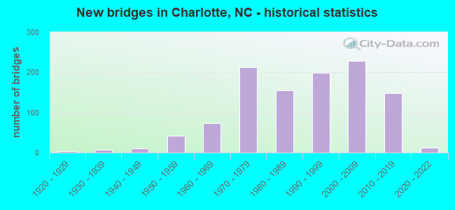
- New bridges - historical statistics
- 31920-1929
- 71930-1939
- 101940-1949
- 411950-1959
- 741960-1969
- 2131970-1979
- 1561980-1989
- 1981990-1999
- 2282000-2009
- 1482010-2019
- 122020-2022
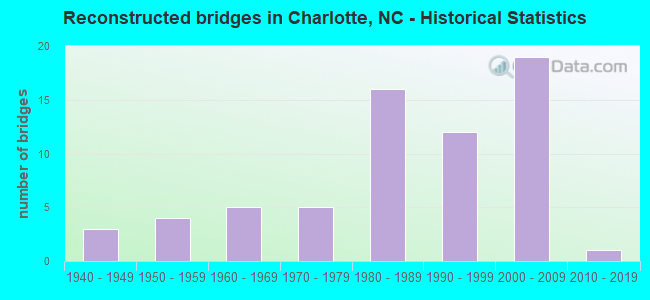
- Reconstructed bridges - Historical Statistics
- 31940-1949
- 41950-1959
- 51960-1969
- 51970-1979
- 161980-1989
- 121990-1999
- 192000-2009
- 12010-2019
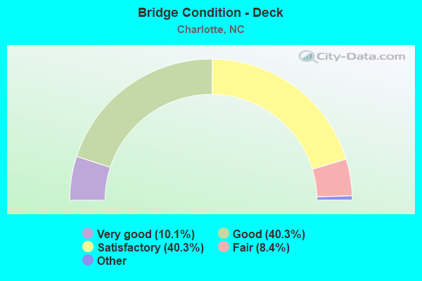
- Bridge Condition - Deck
- 10.1%Excellent
- 40.3%Very good
- 40.3%Good
- 8.4%Satisfactory
- 1.0%Fair
- 0.7%Poor
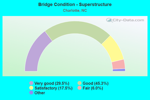
- Bridge Condition - Superstructure
- 29.5%Excellent
- 45.3%Very good
- 17.5%Good
- 6.0%Satisfactory
- 1.7%Fair
- 0.7%Poor
- 0.5%Serious
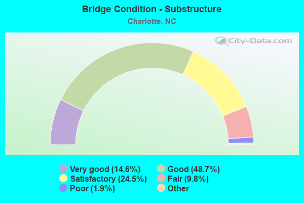
- Bridge Condition - Substructure
- 14.6%Excellent
- 48.7%Very good
- 24.5%Good
- 9.8%Satisfactory
- 1.9%Fair
- 0.5%Poor
- 0.2%Serious
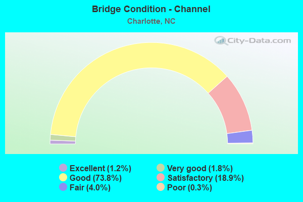
- Bridge Condition - Channel
- 1.2%Excellent
- 1.8%Very good
- 73.8%Good
- 18.9%Satisfactory
- 4.0%Fair
- 0.3%Poor
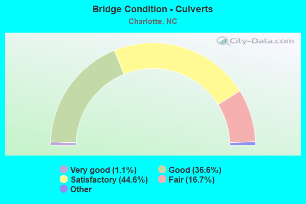
- Bridge Condition - Culverts
- 1.1%Excellent
- 36.6%Very good
- 44.6%Good
- 16.7%Satisfactory
- 1.1%Fair
- 0.5%Serious
Find on map >> Show street view
Structure Number: 1190801, Location: 1.0 MI. N. JCT. SR3448 (Lat: 35.102342, Lng: -80.709017), Route carried "on" structure: Interstate 485, Year Built: 1997, Status: Open, Structure Length: 5.33m (17.49ft), Average Daily Traffic: 38,000 (year 2015), Truck Traffic: 16%, Average Future Daily Traffic: 76,000 (year 2040), Design Load: HS 20+Mod, Features Intersected: SR1010
Minimum Vertical Clearance: 30+ m (98+ ft), Kilometerpoint: 15.880, Lanes on structure: 2, Lanes under structure: 3, Base Highway Network: Yes (Inventory Route: 1, Subroute: 85), Owner: State Highway Agency, Approaching Roadway Width: 10.6m (34.8ft), Skew: 10 degrees, Material/Design: Steel, Design/Construction: Stringer/Multi-beam, Number Of Spans In Main Unit: 3, Length of Maximum Span: 28.9m (94.8ft), Curb-To-Curb Width: 14.0m (45.9ft), Out-to-Out Width: 14.9m (48.9ft)
Condition: Deck: Satisfactory, Superstructure: Very good, Substructure: Satisfactory, Operating Rating: 71.6 metric tons, Method Used To Determine Operating Rating: Load Factor (LF), Inventory Rating: 42.6 metric tons, Method Used To Determine Inventory Rating: Load Factor (LF), Structural Evaluation: Equal to present minimum criteria, Deck Geometry: Superior to present desirable criteria, Underclear: Somewhat better than minimum adequacy, Approach Roadway Alignment: Equal to present desirable criteria, Designated Inspection Frequency: Every 24 months, Inspection Date: March 2021, Deck Structure Type: Concrete Cast-file-Place, Wearing Surface/Protective System: Wearing Surface: Monolithic Concrete
Find on map >> Show street view
Structure Number: 1190805, Location: 0.9 MI. S. JCT. SR1138 (Lat: 35.128011, Lng: -80.917183), Route carried "on" structure: Ramp Interstate 77, Year Built: 1997, Status: Open, Structure Length: 8.35m (27.40ft), Average Daily Traffic: 9,500 (year 2013), Truck Traffic: 16%, Average Future Daily Traffic: 19,000 (year 2040), Design Load: HS 20+Mod, Features Intersected: SUGAR CREEK
Minimum Vertical Clearance: 30+ m (98+ ft), Kilometerpoint: 0.548, Lanes on structure: 2, Owner: State Highway Agency, Approaching Roadway Width: 12.1m (39.7ft), Skew: 9 degrees, Material/Design: Prestressed concrete, Design/Construction: Stringer/Multi-beam, Number Of Spans In Main Unit: 3, Length of Maximum Span: 27.4m (89.9ft), Curb-To-Curb Width: 12.1m (39.7ft), Out-to-Out Width: 13.1m (43.0ft)
Condition: Deck: Good, Superstructure: Good, Substructure: Good, Channel: Good, Operating Rating: 89.8 metric tons, Method Used To Determine Operating Rating: Load Factor (LF), Inventory Rating: 38.1 metric tons, Method Used To Determine Inventory Rating: Load Factor (LF), Structural Evaluation: Better than present minimum criteria, Deck Geometry: Superior to present desirable criteria, Waterway Adequacy: Better than present minimum criteria, Approach Roadway Alignment: Equal to present desirable criteria, Designated Inspection Frequency: Every 24 months, Inspection Date: May 2021, Deck Structure Type: Concrete Cast-file-Place, Wearing Surface/Protective System: Wearing Surface: Monolithic Concrete
Find on map >> Show street view
Structure Number: 1190806, Location: 0.7 MI. N. JCT. SR1142 (Lat: 35.141683, Lng: -80.931564), Route carried "on" structure: State highway 49, Year Built: 1997, Status: Open, Structure Length: 7.62m (25.00ft), Average Daily Traffic: 35,500 (year 2018), Truck Traffic: 12%, Average Future Daily Traffic: 71,000 (year 2040), Design Load: HS 20+Mod, Features Intersected: I485
Minimum Vertical Clearance: 30+ m (98+ ft), Kilometerpoint: 0.000, Lanes on structure: 6, Lanes under structure: 7, Base Highway Network: Yes (Inventory Route: 3, Subroute: 49), Owner: State Highway Agency, Approaching Roadway Width: 24.3m (79.7ft), Skew: 20 degrees, Material/Design: Steel, Design/Construction: Stringer/Multi-beam, Number Of Spans In Main Unit: 2, Length of Maximum Span: 38.4m (126.0ft), Curb or Sidewalk Widths: Left: 0.0m, Right: 1.5m (4.9ft), Curb-To-Curb Width: 24.3m (79.7ft), Out-to-Out Width: 26.7m (87.6ft)
Condition: Deck: Good, Superstructure: Very good, Substructure: Good, Operating Rating: 89.8 metric tons, Method Used To Determine Operating Rating: Load Factor (LF), Inventory Rating: 63.5 metric tons, Method Used To Determine Inventory Rating: Load Factor (LF), Structural Evaluation: Better than present minimum criteria, Deck Geometry: Somewhat better than minimum adequacy, Underclear: Equal to present minimum criteria, Approach Roadway Alignment: Equal to present desirable criteria, Designated Inspection Frequency: Every 24 months, Inspection Date: May 2021, Deck Structure Type: Concrete Cast-file-Place, Wearing Surface/Protective System: Wearing Surface: Monolithic Concrete, Deck Protection: Epoxy Coated Reinforcing
Find on map >> Show street view
Structure Number: 1190807, Location: 0.9 MI. N. JCT. SR1128 (Lat: 35.124692, Lng: -80.919619), Route carried "on" structure: Ramp Interstate 485, Year Built: 1997, Status: Open, Structure Length: 0.79m (2.59ft), Average Daily Traffic: 2,500 (year 2012), Truck Traffic: 16%, Average Future Daily Traffic: 5,000 (year 2040), Design Load: HS 20+Mod, Features Intersected: WESTINGHOUSE BRANCH
Minimum Vertical Clearance: 30+ m (98+ ft), Kilometerpoint: 0.000, Lanes on structure: 2, Owner: State Highway Agency, Approaching Roadway Width: 10.3m (33.8ft), Skew: 3 degrees, Material/Design: Concrete continuous, Design/Construction: Culvert, Number Of Spans In Main Unit: 3, Length of Maximum Span: 2.1m (6.9ft)
Condition: Channel: Good, Culverts: Satisfactory, Operating Rating: 89.8 metric tons, Method Used To Determine Operating Rating: Load and Resistance Factor (LRFR), Inventory Rating: 89.8 metric tons, Method Used To Determine Inventory Rating: Load and Resistance Factor (LRFR), Structural Evaluation: Equal to present minimum criteria, Waterway Adequacy: Better than present minimum criteria, Approach Roadway Alignment: Equal to present desirable criteria, Designated Inspection Frequency: Every 24 months, Inspection Date: July 2020
Find on map >> Show street view
Structure Number: 1190808, Location: 0.79 MI. N. JCT. NC16 (Lat: 35.218236, Lng: -80.819272), Route carried "on" structure: Other road , Year Built: 2020, Status: Open, Structure Length: 6.52m (21.39ft), Average Daily Traffic: 12,000 (year 2016), Truck Traffic: 7%, Average Future Daily Traffic: 24,000 (year 2040), Design Load: HS 20+Mod, Features Intersected: US74, Facility Carried by Structure: HAWTHORNE LN
Minimum Vertical Clearance: 30+ m (98+ ft), Kilometerpoint: 0.000, Lanes on structure: 2, Lanes under structure: 8, Owner: State Highway Agency, Approaching Roadway Width: 10.6m (34.8ft), Skew: 37 degrees, Material/Design: Steel continuous, Design/Construction: Stringer/Multi-beam, Number Of Spans In Main Unit: 2, Length of Maximum Span: 32.0m (105.0ft), Curb or Sidewalk Widths: Left: 2.9m (9.5ft), Right: 2.7m (8.9ft), Curb-To-Curb Width: 10.9m (35.8ft), Out-to-Out Width: 19.7m (64.6ft)
Condition: Deck: Very good, Superstructure: Very good, Substructure: Very good, Operating Rating: 89.8 metric tons, Method Used To Determine Operating Rating: Load and Resistance Factor (LRFR), Inventory Rating: 81.6 metric tons, Method Used To Determine Inventory Rating: Load and Resistance Factor (LRFR), Structural Evaluation: Equal to present desirable criteria, Deck Geometry: Meets minimum limits, Underclear: High priority of corrective action, Approach Roadway Alignment: Equal to present desirable criteria, Designated Inspection Frequency: Every 24 months, Inspection Date: April 2021, Deck Structure Type: Concrete Cast-file-Place, Wearing Surface/Protective System: Wearing Surface: Monolithic Concrete
Find on map >> Show street view
Structure Number: 1190809, Location: 0.4 MI. E. JCT. SR1142 (Lat: 35.154322, Lng: -80.947344), Route carried "on" structure: State highway 1143, Year Built: 1998, Status: Open, Structure Length: 7.71m (25.30ft), Average Daily Traffic: 2,000 (year 1998), Truck Traffic: 7%, Average Future Daily Traffic: 4,000 (year 2040), Design Load: HS 20+Mod, Features Intersected: I485
Minimum Vertical Clearance: 30+ m (98+ ft), Kilometerpoint: 0.000, Lanes on structure: 4, Lanes under structure: 6, Owner: State Highway Agency, Approaching Roadway Width: 21.3m (69.9ft), Skew: 20 degrees, Material/Design: Steel continuous, Design/Construction: Stringer/Multi-beam, Number Of Spans In Main Unit: 2, Length of Maximum Span: 39.0m (128.0ft), Curb-To-Curb Width: 22.7m (74.5ft), Out-to-Out Width: 23.7m (77.8ft)
Condition: Deck: Satisfactory, Superstructure: Good, Substructure: Good, Operating Rating: 89.8 metric tons, Method Used To Determine Operating Rating: Load Factor (LF), Inventory Rating: 57.1 metric tons, Method Used To Determine Inventory Rating: Load Factor (LF), Structural Evaluation: Better than present minimum criteria, Deck Geometry: Superior to present desirable criteria, Underclear: Equal to present minimum criteria, Approach Roadway Alignment: Equal to present desirable criteria, Designated Inspection Frequency: Every 24 months, Inspection Date: July 2020, Deck Structure Type: Concrete Cast-file-Place, Wearing Surface/Protective System: Wearing Surface: Monolithic Concrete, Deck Protection: Epoxy Coated Reinforcing
Find on map >> Show street view
Structure Number: 119081, Location: 0.01 MI. E. JCT. US521 (Lat: 35.047094, Lng: -80.847714), Route carried "on" structure: City street , Year Built: 1998, Status: Open, Structure Length: 0.73m (2.40ft), Average Daily Traffic: 500 (year 2003), Truck Traffic: 7%, Average Future Daily Traffic: 1,050 (year 2040), Design Load: HS 20+Mod, Features Intersected: GOLF CART PATH, Facility Carried by Structure: BALLANTYNE CR. AVE
Minimum Vertical Clearance: 30+ m (98+ ft), Kilometerpoint: 0.000, Lanes on structure: 2, Owner: City or Municipal Highway Agency, Approaching Roadway Width: 13.1m (43.0ft), Material/Design: Concrete, Design/Construction: Culvert, Number Of Spans In Main Unit: 1, Length of Maximum Span: 7.3m (24.0ft), Curb or Sidewalk Widths: Left: 2.8m (9.2ft), Right: 2.6m (8.5ft), Curb-To-Curb Width: 16.4m (53.8ft), Out-to-Out Width: 23.0m (75.5ft)
Condition: Culverts: Good, Operating Rating: 41.7 metric tons, Method Used To Determine Operating Rating: Field evaluation and documented engineering judgment, Inventory Rating: 32.6 metric tons, Method Used To Determine Inventory Rating: Field evaluation and documented engineering judgment, Structural Evaluation: Better than present minimum criteria, Deck Geometry: Superior to present desirable criteria, Approach Roadway Alignment: Equal to present desirable criteria, Designated Inspection Frequency: Every 24 months, Inspection Date: May 2020
Find on map >> Show street view
Structure Number: 1190811, Location: 0.7 MI. W. JCT.NC29 (Lat: 35.291006, Lng: -80.769214), Route carried "on" structure: State highway 5383, Year Built: 2002, Status: Open, Structure Length: 7.19m (23.59ft), Average Daily Traffic: 11,000 (year 2012), Truck Traffic: 7%, Average Future Daily Traffic: 22,000 (year 2040), Design Load: HS 20+Mod, Features Intersected: I85
Minimum Vertical Clearance: 30+ m (98+ ft), Kilometerpoint: 0.000, Lanes on structure: 4, Lanes under structure: 9, Owner: State Highway Agency, Approaching Roadway Width: 27.4m (89.9ft), Skew: 21 degrees, Material/Design: Steel continuous, Design/Construction: Stringer/Multi-beam, Number Of Spans In Main Unit: 2, Length of Maximum Span: 35.6m (116.8ft), Curb-To-Curb Width: 27.3m (89.6ft), Out-to-Out Width: 30.3m (99.4ft)
Condition: Deck: Satisfactory, Superstructure: Good, Substructure: Good, Operating Rating: 89.8 metric tons, Method Used To Determine Operating Rating: Load Factor (LF), Inventory Rating: 59.8 metric tons, Method Used To Determine Inventory Rating: Load Factor (LF), Structural Evaluation: Better than present minimum criteria, Deck Geometry: Superior to present desirable criteria, Underclear: Equal to present minimum criteria, Approach Roadway Alignment: Equal to present desirable criteria, Designated Inspection Frequency: Every 24 months, Inspection Date: August 2020, Deck Structure Type: Concrete Cast-file-Place, Wearing Surface/Protective System: Wearing Surface: Monolithic Concrete, Deck Protection: Epoxy Coated Reinforcing
Find on map >> Show street view
Structure Number: 1190812, Location: 0.3 MI. W. JCT. I85 (Lat: 35.292447, Lng: -80.773408), Route carried "on" structure: State highway 5383, Year Built: 2002, Status: Open, Structure Length: 0.70m (2.30ft), Average Daily Traffic: 11,000 (year 2012), Truck Traffic: 6%, Average Future Daily Traffic: 22,000 (year 2040), Design Load: HS 20+Mod, Features Intersected: DOBY CREEK
Minimum Vertical Clearance: 30+ m (98+ ft), Kilometerpoint: 0.000, Lanes on structure: 4, Owner: State Highway Agency, Approaching Roadway Width: 22.2m (72.8ft), Skew: 20 degrees, Material/Design: Concrete continuous, Design/Construction: Culvert, Number Of Spans In Main Unit: 2, Length of Maximum Span: 3.3m (10.8ft)
Condition: Channel: Good, Culverts: Satisfactory, Operating Rating: 41.7 metric tons, Method Used To Determine Operating Rating: Field evaluation and documented engineering judgment, Inventory Rating: 32.6 metric tons, Method Used To Determine Inventory Rating: Field evaluation and documented engineering judgment, Structural Evaluation: Equal to present minimum criteria, Waterway Adequacy: Better than present minimum criteria, Approach Roadway Alignment: Equal to present desirable criteria, Designated Inspection Frequency: Every 24 months, Inspection Date: August 2020
Find on map >> Show street view
Structure Number: 1190815, Location: 0.4 MI. N. JCT. SR1625 (Lat: 35.251175, Lng: -80.975681), Route carried "on" structure: Ramp Interstate 85, Year Built: 2005, Status: Open, Structure Length: 7.07m (23.20ft), Average Daily Traffic: 74,500 (year 2019), Truck Traffic: 16%, Average Future Daily Traffic: 149,000 (year 2040), Design Load: HS 20+Mod, Features Intersected: I85 NBL RAMP
Minimum Vertical Clearance: 30+ m (98+ ft), Kilometerpoint: 8.869, Lanes on structure: 2, Lanes under structure: 1, Owner: State Highway Agency, Approaching Roadway Width: 13.4m (44.0ft), Skew: 6 degrees, Material/Design: Steel continuous, Design/Construction: Stringer/Multi-beam, Number Of Spans In Main Unit: 3, Length of Maximum Span: 28.9m (94.8ft), Curb-To-Curb Width: 11.1m (36.4ft), Out-to-Out Width: 12.3m (40.4ft)
Condition: Deck: Satisfactory, Superstructure: Very good, Substructure: Good, Operating Rating: 58.0 metric tons, Method Used To Determine Operating Rating: Load Factor (LF), Inventory Rating: 33.5 metric tons, Method Used To Determine Inventory Rating: Load Factor (LF), Structural Evaluation: Better than present minimum criteria, Deck Geometry: Equal to present desirable criteria, Underclear: Superior to present desirable criteria, Approach Roadway Alignment: Equal to present desirable criteria, Designated Inspection Frequency: Every 24 months, Inspection Date: September 2021, Deck Structure Type: Concrete Cast-file-Place, Wearing Surface/Protective System: Wearing Surface: Monolithic Concrete, Deck Protection: Epoxy Coated Reinforcing
Find on map >> Show street view
Structure Number: 1190816, Location: 0.4 MI. E. JCT. SR1625 (Lat: 35.252294, Lng: -80.975497), Route carried "on" structure: Ramp Interstate 485, Year Built: 2005, Status: Open, Structure Length: 7.22m (23.69ft), Average Daily Traffic: 8,250 (year 2010), Truck Traffic: 16%, Average Future Daily Traffic: 16,500 (year 2040), Design Load: HS 20+Mod, Features Intersected: I85 SBL RAMP
Minimum Vertical Clearance: 30+ m (98+ ft), Kilometerpoint: 0.000, Lanes on structure: 2, Lanes under structure: 1, Owner: State Highway Agency, Approaching Roadway Width: 12.4m (40.7ft), Skew: 6 degrees, Material/Design: Steel continuous, Design/Construction: Stringer/Multi-beam, Number Of Spans In Main Unit: 3, Length of Maximum Span: 28.3m (92.8ft), Curb-To-Curb Width: 11.1m (36.4ft), Out-to-Out Width: 12.3m (40.4ft)
Condition: Deck: Good, Superstructure: Very good, Substructure: Very good, Operating Rating: 82.5 metric tons, Method Used To Determine Operating Rating: Load Factor (LF), Inventory Rating: 49.8 metric tons, Method Used To Determine Inventory Rating: Load Factor (LF), Structural Evaluation: Equal to present desirable criteria, Deck Geometry: Equal to present desirable criteria, Underclear: Superior to present desirable criteria, Approach Roadway Alignment: Equal to present desirable criteria, Designated Inspection Frequency: Every 24 months, Inspection Date: April 2020, Deck Structure Type: Concrete Cast-file-Place, Wearing Surface/Protective System: Wearing Surface: Monolithic Concrete, Deck Protection: Epoxy Coated Reinforcing
Find on map >> Show street view
Structure Number: 1190817, Location: 0.9 MI. N. JCT. SR1625 (Lat: 35.247753, Lng: -80.967842), Route carried "on" structure: Ramp Interstate 85, Year Built: 2005, Status: Open, Structure Length: 30.20m (99.08ft), Average Daily Traffic: 36,000 (year 2012), Truck Traffic: 16%, Average Future Daily Traffic: 72,000 (year 2040), Design Load: HS 20+Mod, Features Intersected: I85, I485
Minimum Vertical Clearance: 30+ m (98+ ft), Kilometerpoint: 2.956, Lanes on structure: 2, Lanes under structure: 19, Owner: State Highway Agency, Approaching Roadway Width: 13.1m (43.0ft), Skew: 9 degrees, Material/Design: Steel continuous, Design/Construction: Stringer/Multi-beam, Number Of Spans In Main Unit: 8, Length of Maximum Span: 57.6m (189.0ft), Curb-To-Curb Width: 13.1m (43.0ft), Out-to-Out Width: 14.1m (46.3ft)
Condition: Deck: Satisfactory, Superstructure: Very good, Substructure: Good, Operating Rating: 59.8 metric tons, Method Used To Determine Operating Rating: Load Factor (LF), Inventory Rating: 35.3 metric tons, Method Used To Determine Inventory Rating: Load Factor (LF), Structural Evaluation: Better than present minimum criteria, Deck Geometry: Superior to present desirable criteria, Underclear: Meets minimum limits, Approach Roadway Alignment: Equal to present desirable criteria, Designated Inspection Frequency: Every 24 months, Inspection Date: April 2020, Deck Structure Type: Concrete Cast-file-Place, Wearing Surface/Protective System: Wearing Surface: Monolithic Concrete, Deck Protection: Epoxy Coated Reinforcing
Find on map >> Show street view
Structure Number: 1190818, Location: 0.3M. E. JCT. I85 (Lat: 35.251394, Lng: -80.968375), Route carried "on" structure: Ramp Interstate 485, Year Built: 2005, Status: Open, Structure Length: 10.14m (33.27ft), Average Daily Traffic: 14,375 (year 2019), Truck Traffic: 16%, Average Future Daily Traffic: 28,750 (year 2040), Design Load: HS 20+Mod, Features Intersected: I485
Minimum Vertical Clearance: 30+ m (98+ ft), Kilometerpoint: 3.169, Lanes on structure: 2, Lanes under structure: 8, Owner: State Highway Agency, Approaching Roadway Width: 13.7m (44.9ft), Skew: 9 degrees, Material/Design: Steel continuous, Design/Construction: Stringer/Multi-beam, Number Of Spans In Main Unit: 3, Length of Maximum Span: 40.8m (133.9ft), Curb-To-Curb Width: 13.1m (43.0ft), Out-to-Out Width: 14.1m (46.3ft)
Condition: Deck: Good, Superstructure: Good, Substructure: Good, Operating Rating: 47.1 metric tons, Method Used To Determine Operating Rating: Load Factor (LF), Inventory Rating: 29.0 metric tons, Method Used To Determine Inventory Rating: Load Factor (LF), Structural Evaluation: Better than present minimum criteria, Deck Geometry: Superior to present desirable criteria, Underclear: Equal to present minimum criteria, Approach Roadway Alignment: Equal to present desirable criteria, Designated Inspection Frequency: Every 24 months, Inspection Date: Febuary 2022, Deck Structure Type: Concrete Cast-file-Place, Wearing Surface/Protective System: Wearing Surface: Monolithic Concrete, Deck Protection: Epoxy Coated Reinforcing
Find on map >> Show street view
Structure Number: 1190819, Location: 1.0 MI. N. JCT.SR1625 (Lat: 35.248950, Lng: -80.968633), Route carried "on" structure: Interstate 85, Year Built: 2005, Status: Open, Structure Length: 10.18m (33.40ft), Average Daily Traffic: 149,000 (year 2019), Truck Traffic: 16%, Average Future Daily Traffic: 298,000 (year 2040), Design Load: HS 20+Mod, Features Intersected: I485
Minimum Vertical Clearance: 30+ m (98+ ft), Kilometerpoint: 9.174, Lanes on structure: 10, Lanes under structure: 9, Base Highway Network: Yes (Inventory Route: 1, Subroute: 85), Owner: State Highway Agency, Approaching Roadway Width: 45.7m (149.9ft), Skew: 32 degrees, Material/Design: Steel continuous, Design/Construction: Stringer/Multi-beam, Number Of Spans In Main Unit: 3, Length of Maximum Span: 39.6m (129.9ft), Curb-To-Curb Width: 45.8m (150.3ft), Out-to-Out Width: 47.7m (156.5ft)
Condition: Deck: Fair, Superstructure: Very good, Substructure: Satisfactory, Operating Rating: 89.8 metric tons, Method Used To Determine Operating Rating: Load Factor (LF), Inventory Rating: 69.8 metric tons, Method Used To Determine Inventory Rating: Load Factor (LF), Structural Evaluation: Equal to present minimum criteria, Deck Geometry: Superior to present desirable criteria, Underclear: Equal to present minimum criteria, Approach Roadway Alignment: Equal to present desirable criteria, Designated Inspection Frequency: Every 24 months, Inspection Date: September 2021, Deck Structure Type: Concrete Cast-file-Place, Wearing Surface/Protective System: Wearing Surface: Monolithic Concrete, Deck Protection: Epoxy Coated Reinforcing
Find on map >> Show street view
Structure Number: 119082, Location: 1.1 MI. E. JCT. SR1625 (Lat: 35.248519, Lng: -80.967525), Route carried "on" structure: Interstate 85, Year Built: 2005, Status: Open, Structure Length: 3.96m (12.99ft), Average Daily Traffic: 119,000 (year 2018), Truck Traffic: 16%, Average Future Daily Traffic: 238,000 (year 2040), Design Load: HS 20+Mod, Features Intersected: I485 NBL RAMP
Minimum Vertical Clearance: 30+ m (98+ ft), Kilometerpoint: 9.174, Lanes on structure: 9, Lanes under structure: 2, Base Highway Network: Yes (Inventory Route: 1, Subroute: 85), Owner: State Highway Agency, Approaching Roadway Width: 42.6m (139.8ft), Skew: 30 degrees, Material/Design: Steel, Design/Construction: Stringer/Multi-beam, Number Of Spans In Main Unit: 1, Length of Maximum Span: 39.0m (128.0ft), Curb-To-Curb Width: 43.6m (143.0ft), Out-to-Out Width: 45.3m (148.6ft)
Condition: Deck: Good, Superstructure: Very good, Substructure: Good, Operating Rating: 89.8 metric tons, Method Used To Determine Operating Rating: Load Factor (LF), Inventory Rating: 57.1 metric tons, Method Used To Determine Inventory Rating: Load Factor (LF), Structural Evaluation: Better than present minimum criteria, Deck Geometry: Superior to present desirable criteria, Underclear: Equal to present desirable criteria, Approach Roadway Alignment: Equal to present desirable criteria, Designated Inspection Frequency: Every 24 months, Inspection Date: Febuary 2022, Deck Structure Type: Concrete Cast-file-Place, Wearing Surface/Protective System: Wearing Surface: Monolithic Concrete
Find on map >> Show street view
Structure Number: 1190821, Location: 0.8 MI. S. JCT. NC160 (Lat: 35.162631, Lng: -80.952597), Route carried "on" structure: State highway 1142, Year Built: 2006, Status: Open, Structure Length: 11.64m (38.19ft), Average Daily Traffic: 500 (year 2007), Truck Traffic: 7%, Average Future Daily Traffic: 1,000 (year 2040), Design Load: HS 20+Mod, Features Intersected: I485
Minimum Vertical Clearance: 30+ m (98+ ft), Kilometerpoint: 0.000, Lanes on structure: 2, Lanes under structure: 8, Owner: State Highway Agency, Approaching Roadway Width: 12.1m (39.7ft), Skew: 4 degrees, Material/Design: Steel continuous, Design/Construction: Stringer/Multi-beam, Number Of Spans In Main Unit: 2, Number Of Approach Spans: 2, Length of Maximum Span: 39.9m (130.9ft), Curb-To-Curb Width: 13.1m (43.0ft), Out-to-Out Width: 13.8m (45.3ft)
Condition: Deck: Good, Superstructure: Good, Substructure: Good, Operating Rating: 89.8 metric tons, Method Used To Determine Operating Rating: Load Factor (LF), Inventory Rating: 54.4 metric tons, Method Used To Determine Inventory Rating: Load Factor (LF), Structural Evaluation: Better than present minimum criteria, Deck Geometry: Superior to present desirable criteria, Underclear: Better than present minimum criteria, Approach Roadway Alignment: Equal to present desirable criteria, Designated Inspection Frequency: Every 24 months, Inspection Date: Febuary 2022, Deck Structure Type: Concrete Cast-file-Place, Wearing Surface/Protective System: Wearing Surface: Monolithic Concrete, Deck Protection: Epoxy Coated Reinforcing
Find on map >> Show street view
Structure Number: 1190822, Location: 0.5 MI. N. JCT. SR1116 (Lat: 35.166917, Lng: -80.965461), Route carried "on" structure: State highway 160, Year Built: 2006, Status: Open, Structure Length: 7.46m (24.48ft), Average Daily Traffic: 19,000 (year 2018), Truck Traffic: 12%, Average Future Daily Traffic: 38,000 (year 2040), Design Load: HS 15, Features Intersected: I485
Minimum Vertical Clearance: 30+ m (98+ ft), Kilometerpoint: 0.000, Lanes on structure: 6, Lanes under structure: 8, Base Highway Network: Yes (Inventory Route: 3, Subroute: 60), Owner: State Highway Agency, Approaching Roadway Width: 28.9m (94.8ft), Material/Design: Steel continuous, Design/Construction: Stringer/Multi-beam, Number Of Spans In Main Unit: 2, Length of Maximum Span: 39.9m (130.9ft), Curb-To-Curb Width: 28.7m (94.2ft), Out-to-Out Width: 29.6m (97.1ft)
Condition: Deck: Good, Superstructure: Good, Substructure: Good, Operating Rating: 65.3 metric tons, Method Used To Determine Operating Rating: Load Factor (LF), Inventory Rating: 39.0 metric tons, Method Used To Determine Inventory Rating: Load Factor (LF), Structural Evaluation: Better than present minimum criteria, Deck Geometry: High priority of corrective action, Underclear: Equal to present minimum criteria, Approach Roadway Alignment: Equal to present desirable criteria, Designated Inspection Frequency: Every 24 months, Inspection Date: November 2021, Deck Structure Type: Concrete Cast-file-Place, Wearing Surface/Protective System: Wearing Surface: Monolithic Concrete, Deck Protection: Epoxy Coated Reinforcing
Find on map >> Show street view
Structure Number: 1190823, Location: 0.38 MI. N. JCT. NC160 (Lat: 35.171994, Lng: -80.968961), Route carried "on" structure: State highway 1155, Year Built: 2002, Status: Open, Structure Length: 7.52m (24.67ft), Average Daily Traffic: 10,500 (year 2018), Truck Traffic: 7%, Average Future Daily Traffic: 21,000 (year 2040), Design Load: HS 20+Mod, Features Intersected: I485
Minimum Vertical Clearance: 30+ m (98+ ft), Kilometerpoint: 0.000, Lanes on structure: 2, Lanes under structure: 7, Owner: State Highway Agency, Approaching Roadway Width: 6.7m (22.0ft), Skew: 1 degrees, Material/Design: Steel continuous, Design/Construction: Stringer/Multi-beam, Number Of Spans In Main Unit: 2, Length of Maximum Span: 40.8m (133.9ft), Curb or Sidewalk Widths: Left: 0.1m (0.3ft), Right: 0.1m (0.3ft), Curb-To-Curb Width: 9.1m (29.9ft), Out-to-Out Width: 10.1m (33.1ft)
Condition: Deck: Very good, Superstructure: Good, Substructure: Good, Operating Rating: 66.2 metric tons, Method Used To Determine Operating Rating: Load Factor (LF), Inventory Rating: 39.9 metric tons, Method Used To Determine Inventory Rating: Load Factor (LF), Structural Evaluation: Better than present minimum criteria, Deck Geometry: Meets minimum limits, Underclear: Equal to present minimum criteria, Approach Roadway Alignment: Equal to present desirable criteria, Designated Inspection Frequency: Every 24 months, Inspection Date: October 2021, Deck Structure Type: Concrete Cast-file-Place, Wearing Surface/Protective System: Wearing Surface: Monolithic Concrete, Deck Protection: Epoxy Coated Reinforcing
Find on map >> Show street view
Structure Number: 1190824, Location: 0.6 MI. S. JCT. NC160 (Lat: 35.190950, Lng: -80.968731), Route carried "on" structure: State highway 1148, Year Built: 2006, Status: Open, Structure Length: 7.19m (23.59ft), Average Daily Traffic: 6,705 (year 2016), Truck Traffic: 12%, Average Future Daily Traffic: 13,410 (year 2040), Design Load: HS 20+Mod, Features Intersected: I485
Minimum Vertical Clearance: 30+ m (98+ ft), Kilometerpoint: 0.000, Lanes on structure: 2, Lanes under structure: 6, Base Highway Network: Yes (Inventory Route: 3, Subroute: 48), Owner: State Highway Agency, Approaching Roadway Width: 14.3m (46.9ft), Material/Design: Steel continuous, Design/Construction: Stringer/Multi-beam, Number Of Spans In Main Unit: 2, Length of Maximum Span: 35.9m (117.8ft), Curb-To-Curb Width: 15.4m (50.5ft), Out-to-Out Width: 16.5m (54.1ft)
Condition: Deck: Good, Superstructure: Good, Substructure: Good, Operating Rating: 68.0 metric tons, Method Used To Determine Operating Rating: Load Factor (LF), Inventory Rating: 40.8 metric tons, Method Used To Determine Inventory Rating: Load Factor (LF), Structural Evaluation: Better than present minimum criteria, Deck Geometry: High priority of corrective action, Underclear: Equal to present minimum criteria, Approach Roadway Alignment: Equal to present desirable criteria, Designated Inspection Frequency: Every 24 months, Inspection Date: November 2021, Deck Structure Type: Concrete Cast-file-Place, Wearing Surface/Protective System: Wearing Surface: Monolithic Concrete
Find on map >> Show street view
Structure Number: 1190825, Location: .025 MI. S. JCT. SR1195 (Lat: 35.203431, Lng: -80.968253), Route carried "on" structure: State highway 1184, Year Built: 2006, Status: Open, Structure Length: 6.76m (22.18ft), Average Daily Traffic: 830 (year 2014), Truck Traffic: 7%, Average Future Daily Traffic: 1,660 (year 2040), Design Load: HS 20+Mod, Features Intersected: I485
Minimum Vertical Clearance: 30+ m (98+ ft), Kilometerpoint: 0.000, Lanes on structure: 2, Lanes under structure: 6, Owner: State Highway Agency, Approaching Roadway Width: 6.7m (22.0ft), Material/Design: Steel continuous, Design/Construction: Stringer/Multi-beam, Number Of Spans In Main Unit: 2, Length of Maximum Span: 33.5m (109.9ft), Curb-To-Curb Width: 8.9m (29.2ft), Out-to-Out Width: 10.1m (33.1ft)
Condition: Deck: Satisfactory, Superstructure: Very good, Substructure: Satisfactory, Operating Rating: 89.8 metric tons, Method Used To Determine Operating Rating: Load Factor (LF), Inventory Rating: 56.2 metric tons, Method Used To Determine Inventory Rating: Load Factor (LF), Structural Evaluation: Equal to present minimum criteria, Deck Geometry: Somewhat better than minimum adequacy, Underclear: Equal to present minimum criteria, Approach Roadway Alignment: Equal to present desirable criteria, Designated Inspection Frequency: Every 24 months, Inspection Date: January 2022, Deck Structure Type: Concrete Cast-file-Place, Wearing Surface/Protective System: Wearing Surface: Monolithic Concrete, Deck Protection: Epoxy Coated Reinforcing
Find on map >> Show street view
Structure Number: 1190826, Location: 170 FT. W. JCT. 1195 (Lat: 35.219550, Lng: -80.969508), Route carried "on" structure: State highway 1193, Year Built: 2006, Status: Open, Structure Length: 7.43m (24.38ft), Average Daily Traffic: 1,000 (year 2007), Truck Traffic: 7%, Average Future Daily Traffic: 2,000 (year 2025), Design Load: HS 20+Mod, Features Intersected: I485
Minimum Vertical Clearance: 30+ m (98+ ft), Kilometerpoint: 0.000, Lanes on structure: 2, Lanes under structure: 6, Owner: State Highway Agency, Approaching Roadway Width: 6.0m (19.7ft), Material/Design: Steel continuous, Design/Construction: Stringer/Multi-beam, Number Of Spans In Main Unit: 2, Length of Maximum Span: 37.4m (122.7ft), Curb-To-Curb Width: 8.9m (29.2ft), Out-to-Out Width: 10.1m (33.1ft)
Condition: Deck: Satisfactory, Superstructure: Good, Substructure: Satisfactory, Operating Rating: 88.9 metric tons, Method Used To Determine Operating Rating: Load Factor (LF), Inventory Rating: 53.5 metric tons, Method Used To Determine Inventory Rating: Load Factor (LF), Structural Evaluation: Equal to present minimum criteria, Deck Geometry: High priority of corrective action, Underclear: Equal to present minimum criteria, Approach Roadway Alignment: Equal to present desirable criteria, Designated Inspection Frequency: Every 24 months, Inspection Date: January 2022, Deck Structure Type: Concrete Cast-file-Place, Wearing Surface/Protective System: Wearing Surface: Monolithic Concrete, Deck Protection: Epoxy Coated Reinforcing
Find on map >> Show street view
Structure Number: 1190827, Location: 0.85 MI. S. JCT. US29 (Lat: 35.227050, Lng: -80.970778), Route carried "on" structure: Interstate 485, Year Built: 2006, Status: Open, Structure Length: 3.44m (11.29ft), Average Daily Traffic: 52,500 (year 2015), Truck Traffic: 16%, Average Future Daily Traffic: 105,000 (year 2040), Design Load: HS 20+Mod, Features Intersected: SR1191
Minimum Vertical Clearance: 30+ m (98+ ft), Kilometerpoint: 2.621, Lanes on structure: 3, Lanes under structure: 2, Base Highway Network: Yes (Inventory Route: 1, Subroute: 85), Owner: State Highway Agency, Approaching Roadway Width: 17.6m (57.7ft), Skew: 12 degrees, Material/Design: Steel, Design/Construction: Stringer/Multi-beam, Number Of Spans In Main Unit: 1, Length of Maximum Span: 33.5m (109.9ft), Curb-To-Curb Width: 17.9m (58.7ft), Out-to-Out Width: 19.1m (62.7ft)
Condition: Deck: Satisfactory, Superstructure: Very good, Substructure: Good, Operating Rating: 89.8 metric tons, Method Used To Determine Operating Rating: Load Factor (LF), Inventory Rating: 55.3 metric tons, Method Used To Determine Inventory Rating: Load Factor (LF), Structural Evaluation: Better than present minimum criteria, Deck Geometry: Better than present minimum criteria, Underclear: Somewhat better than minimum adequacy, Approach Roadway Alignment: Equal to present desirable criteria, Designated Inspection Frequency: Every 24 months, Inspection Date: January 2022, Deck Structure Type: Concrete Cast-file-Place, Wearing Surface/Protective System: Wearing Surface: Monolithic Concrete
Find on map >> Show street view
Structure Number: 1190828, Location: 0.85 MI. S. JCT. US29 (Lat: 35.227181, Lng: -80.971106), Route carried "on" structure: Interstate 485, Year Built: 2006, Status: Open, Structure Length: 3.93m (12.89ft), Average Daily Traffic: 64,500 (year 2019), Truck Traffic: 16%, Average Future Daily Traffic: 129,000 (year 2040), Design Load: HS 20+Mod, Features Intersected: SR1191
Minimum Vertical Clearance: 30+ m (98+ ft), Kilometerpoint: 2.621, Lanes on structure: 5, Lanes under structure: 2, Base Highway Network: Yes (Inventory Route: 1, Subroute: 85), Owner: State Highway Agency, Approaching Roadway Width: 24.6m (80.7ft), Skew: 12 degrees, Material/Design: Steel, Design/Construction: Stringer/Multi-beam, Number Of Spans In Main Unit: 1, Length of Maximum Span: 38.4m (126.0ft), Curb-To-Curb Width: 25.1m (82.3ft), Out-to-Out Width: 26.2m (86.0ft)
Condition: Deck: Satisfactory, Superstructure: Very good, Substructure: Good, Operating Rating: 89.8 metric tons, Method Used To Determine Operating Rating: Load Factor (LF), Inventory Rating: 53.5 metric tons, Method Used To Determine Inventory Rating: Load Factor (LF), Structural Evaluation: Better than present minimum criteria, Deck Geometry: Better than present minimum criteria, Underclear: Equal to present minimum criteria, Approach Roadway Alignment: Equal to present desirable criteria, Designated Inspection Frequency: Every 24 months, Inspection Date: January 2022, Deck Structure Type: Concrete Cast-file-Place, Wearing Surface/Protective System: Wearing Surface: Monolithic Concrete
Find on map >> Show street view
Structure Number: 1190829, Location: 0.7 MI. S. JCT. US29 (Lat: 35.229589, Lng: -80.970886), Route carried "on" structure: Interstate 485, Year Built: 2006, Status: Open, Structure Length: 11.70m (38.39ft), Average Daily Traffic: 46,500 (year 2015), Truck Traffic: 16%, Average Future Daily Traffic: 93,000 (year 2040), Design Load: HS 20+Mod, Features Intersected: SOUTHERN RR.
Minimum Vertical Clearance: 30+ m (98+ ft), Kilometerpoint: 2.682, Lanes on structure: 5, Base Highway Network: Yes (Inventory Route: 9, Subroute: 17), Owner: State Highway Agency, Approaching Roadway Width: 17.9m (58.7ft), Skew: 19 degrees, Material/Design: Steel continuous, Design/Construction: Stringer/Multi-beam, Number Of Spans In Main Unit: 2, Number Of Approach Spans: 2, Length of Maximum Span: 76.2m (250.0ft), Curb-To-Curb Width: 25.1m (82.3ft), Out-to-Out Width: 26.1m (85.6ft)
Condition: Deck: Satisfactory, Superstructure: Very good, Substructure: Satisfactory, Operating Rating: 66.2 metric tons, Method Used To Determine Operating Rating: Load Factor (LF), Inventory Rating: 39.0 metric tons, Method Used To Determine Inventory Rating: Load Factor (LF), Structural Evaluation: Equal to present minimum criteria, Deck Geometry: Better than present minimum criteria, Underclear: Superior to present desirable criteria, Approach Roadway Alignment: Equal to present desirable criteria, Designated Inspection Frequency: Every 24 months, Inspection Date: January 2022, Deck Structure Type: Concrete Cast-file-Place, Wearing Surface/Protective System: Wearing Surface: Monolithic Concrete
Find on map >> Show street view
Structure Number: 119083, Location: 0.7 MI. S. JCT. US29 (Lat: 35.229550, Lng: -80.970592), Route carried "on" structure: Interstate 485, Year Built: 2006, Status: Open, Structure Length: 12.46m (40.88ft), Average Daily Traffic: 46,500 (year 2015), Truck Traffic: 16%, Average Future Daily Traffic: 93,000 (year 2040), Design Load: HS 20+Mod, Features Intersected: SOUTHERN RR.
Minimum Vertical Clearance: 30+ m (98+ ft), Kilometerpoint: 2.682, Lanes on structure: 4, Base Highway Network: Yes (Inventory Route: 9, Subroute: 17), Owner: State Highway Agency, Approaching Roadway Width: 17.3m (56.8ft), Skew: 19 degrees, Material/Design: Steel continuous, Design/Construction: Stringer/Multi-beam, Number Of Spans In Main Unit: 2, Number Of Approach Spans: 2, Length of Maximum Span: 83.5m (274.0ft), Curb-To-Curb Width: 21.5m (70.5ft), Out-to-Out Width: 22.5m (73.8ft)
Condition: Deck: Satisfactory, Superstructure: Very good, Substructure: Satisfactory, Operating Rating: 65.3 metric tons, Method Used To Determine Operating Rating: Load Factor (LF), Inventory Rating: 39.0 metric tons, Method Used To Determine Inventory Rating: Load Factor (LF), Structural Evaluation: Equal to present minimum criteria, Deck Geometry: Better than present minimum criteria, Underclear: Superior to present desirable criteria, Approach Roadway Alignment: Equal to present desirable criteria, Designated Inspection Frequency: Every 24 months, Inspection Date: January 2022, Deck Structure Type: Concrete Cast-file-Place, Wearing Surface/Protective System: Wearing Surface: Monolithic Concrete
Find on map >> Show street view
Structure Number: 1190831, Location: 0.65 MI. S. JCT. I85 (Lat: 35.239406, Lng: -80.969328), Route carried "on" structure: Ramp Interstate 485, Year Built: 2006, Status: Open, Structure Length: 5.69m (18.67ft), Average Daily Traffic: 28,750 (year 2019), Truck Traffic: 16%, Average Future Daily Traffic: 57,500 (year 2040), Design Load: HS 20+Mod, Features Intersected: US29, US74
Minimum Vertical Clearance: 30+ m (98+ ft), Kilometerpoint: 2.926, Lanes on structure: 3, Lanes under structure: 6, Base Highway Network: Yes (Inventory Route: 1, Subroute: 85), Owner: State Highway Agency, Approaching Roadway Width: 14.0m (45.9ft), Skew: 10 degrees, Material/Design: Steel, Design/Construction: Stringer/Multi-beam, Number Of Spans In Main Unit: 3, Length of Maximum Span: 37.7m (123.7ft), Curb-To-Curb Width: 14.1m (46.3ft), Out-to-Out Width: 15.3m (50.2ft)
Condition: Deck: Satisfactory, Superstructure: Very good, Substructure: Good, Operating Rating: 89.8 metric tons, Method Used To Determine Operating Rating: Load Factor (LF), Inventory Rating: 58.0 metric tons, Method Used To Determine Inventory Rating: Load Factor (LF), Structural Evaluation: Better than present minimum criteria, Deck Geometry: Better than present minimum criteria, Underclear: Meets minimum limits, Approach Roadway Alignment: Equal to present desirable criteria, Designated Inspection Frequency: Every 24 months, Inspection Date: January 2022, Deck Structure Type: Concrete Cast-file-Place, Wearing Surface/Protective System: Wearing Surface: Monolithic Concrete
Find on map >> Show street view
Structure Number: 1190832, Location: 0.65 MI. S. JCT. I85 (Lat: 35.239444, Lng: -80.969592), Route carried "on" structure: Interstate 485, Year Built: 2006, Status: Open, Structure Length: 5.82m (19.09ft), Average Daily Traffic: 28,750 (year 2019), Truck Traffic: 16%, Average Future Daily Traffic: 57,500 (year 2040), Design Load: HS 20+Mod, Features Intersected: US29, US74
Minimum Vertical Clearance: 30+ m (98+ ft), Kilometerpoint: 2.926, Lanes on structure: 3, Lanes under structure: 6, Base Highway Network: Yes (Inventory Route: 1, Subroute: 85), Owner: State Highway Agency, Approaching Roadway Width: 17.3m (56.8ft), Skew: 10 degrees, Material/Design: Steel, Design/Construction: Stringer/Multi-beam, Number Of Spans In Main Unit: 3, Length of Maximum Span: 37.7m (123.7ft), Curb-To-Curb Width: 17.8m (58.4ft), Out-to-Out Width: 18.9m (62.0ft)
Condition: Deck: Satisfactory, Superstructure: Very good, Substructure: Good, Operating Rating: 89.8 metric tons, Method Used To Determine Operating Rating: Load Factor (LF), Inventory Rating: 55.3 metric tons, Method Used To Determine Inventory Rating: Load Factor (LF), Structural Evaluation: Better than present minimum criteria, Deck Geometry: High priority of corrective action, Underclear: Meets minimum limits, Approach Roadway Alignment: Equal to present desirable criteria, Designated Inspection Frequency: Every 24 months, Inspection Date: January 2022, Deck Structure Type: Concrete Cast-file-Place, Wearing Surface/Protective System: Wearing Surface: Monolithic Concrete
Find on map >> Show street view
Structure Number: 1190833, Location: 0.65 MI. S. JCT. I85 (Lat: 35.239483, Lng: -80.969853), Route carried "on" structure: Interstate 485, Year Built: 2006, Status: Open, Structure Length: 6.12m (20.08ft), Average Daily Traffic: 28,750 (year 2019), Truck Traffic: 16%, Average Future Daily Traffic: 115,000 (year 2040), Design Load: HS 20+Mod, Features Intersected: US29, US74
Minimum Vertical Clearance: 30+ m (98+ ft), Kilometerpoint: 2.926, Lanes on structure: 3, Lanes under structure: 6, Base Highway Network: Yes (Inventory Route: 1, Subroute: 85), Owner: State Highway Agency, Approaching Roadway Width: 17.3m (56.8ft), Skew: 10 degrees, Material/Design: Steel, Design/Construction: Stringer/Multi-beam, Number Of Spans In Main Unit: 3, Length of Maximum Span: 37.7m (123.7ft), Curb-To-Curb Width: 17.8m (58.4ft), Out-to-Out Width: 18.9m (62.0ft)
Condition: Deck: Satisfactory, Superstructure: Very good, Substructure: Good, Operating Rating: 89.8 metric tons, Method Used To Determine Operating Rating: Load Factor (LF), Inventory Rating: 56.2 metric tons, Method Used To Determine Inventory Rating: Load Factor (LF), Structural Evaluation: Better than present minimum criteria, Deck Geometry: Better than present minimum criteria, Underclear: Somewhat better than minimum adequacy, Approach Roadway Alignment: Equal to present desirable criteria, Designated Inspection Frequency: Every 24 months, Inspection Date: January 2022, Deck Structure Type: Concrete Cast-file-Place, Wearing Surface/Protective System: Wearing Surface: Monolithic Concrete
Find on map >> Show street view
Structure Number: 1190834, Location: 0.65 MI. S. JCT. I85 (Lat: 35.239528, Lng: -80.970150), Route carried "on" structure: Ramp Interstate 485, Year Built: 2006, Status: Open, Structure Length: 6.40m (21.00ft), Average Daily Traffic: 28,750 (year 2019), Truck Traffic: 16%, Average Future Daily Traffic: 57,500 (year 2040), Design Load: HS 20+Mod, Features Intersected: US29, US74
Minimum Vertical Clearance: 30+ m (98+ ft), Kilometerpoint: 2.926, Lanes on structure: 3, Lanes under structure: 6, Base Highway Network: Yes (Inventory Route: 1, Subroute: 85), Owner: State Highway Agency, Approaching Roadway Width: 15.5m (50.9ft), Skew: 10 degrees, Material/Design: Steel, Design/Construction: Stringer/Multi-beam, Number Of Spans In Main Unit: 3, Length of Maximum Span: 37.7m (123.7ft), Curb-To-Curb Width: 15.9m (52.2ft), Out-to-Out Width: 17.1m (56.1ft)
Condition: Deck: Satisfactory, Superstructure: Very good, Substructure: Good, Operating Rating: 89.8 metric tons, Method Used To Determine Operating Rating: Load Factor (LF), Inventory Rating: 64.4 metric tons, Method Used To Determine Inventory Rating: Load Factor (LF), Structural Evaluation: Better than present minimum criteria, Deck Geometry: High priority of corrective action, Underclear: Equal to present minimum criteria, Approach Roadway Alignment: Equal to present desirable criteria, Designated Inspection Frequency: Every 24 months, Inspection Date: January 2022, Deck Structure Type: Concrete Cast-file-Place, Wearing Surface/Protective System: Wearing Surface: Monolithic Concrete
Find on map >> Show street view
Structure Number: 1190835, Location: 0.35 MI. S. JCT. US29 (Lat: 35.234969, Lng: -80.970050), Route carried "on" structure: Interstate 485, Year Built: 2006, Status: Open, Structure Length: 0.88m (2.89ft), Average Daily Traffic: 93,000 (year 2015), Truck Traffic: 16%, Average Future Daily Traffic: 186,000 (year 2040), Design Load: HS 20+Mod, Features Intersected: TIGER BRANCH
Minimum Vertical Clearance: 30+ m (98+ ft), Kilometerpoint: 2.743, Lanes on structure: 9, Base Highway Network: Yes (Inventory Route: 3, Subroute: 85), Owner: State Highway Agency, Approaching Roadway Width: 34.1m (111.9ft), Skew: 22 degrees, Material/Design: Concrete continuous, Design/Construction: Culvert, Number Of Spans In Main Unit: 2, Length of Maximum Span: 3.6m (11.8ft)
Condition: Channel: Satisfactory, Culverts: Fair, Operating Rating: 41.7 metric tons, Method Used To Determine Operating Rating: Field evaluation and documented engineering judgment, Inventory Rating: 32.6 metric tons, Method Used To Determine Inventory Rating: Field evaluation and documented engineering judgment, Structural Evaluation: Somewhat better than minimum adequacy, Waterway Adequacy: Better than present minimum criteria, Approach Roadway Alignment: Equal to present desirable criteria, Designated Inspection Frequency: Every 24 months, Inspection Date: January 2022
Find on map >> Show street view
Structure Number: 1190836, Location: 0.2 MI. S. JCT. US29 (Lat: 35.236506, Lng: -80.968189), Route carried "on" structure: Ramp Interstate 485, Year Built: 2006, Status: Open, Structure Length: 0.76m (2.49ft), Average Daily Traffic: 28,750 (year 2019), Truck Traffic: 16%, Average Future Daily Traffic: 57,500 (year 2040), Design Load: HS 20+Mod, Features Intersected: TIGER BRANCH
Minimum Vertical Clearance: 30+ m (98+ ft), Kilometerpoint: 2.895, Lanes on structure: 2, Owner: State Highway Agency, Approaching Roadway Width: 12.1m (39.7ft), Material/Design: Concrete continuous, Design/Construction: Culvert, Number Of Spans In Main Unit: 2, Length of Maximum Span: 3.6m (11.8ft)
Condition: Channel: Satisfactory, Culverts: Satisfactory, Operating Rating: 49.8 metric tons, Method Used To Determine Operating Rating: Load and Resistance Factor (LRFR), Inventory Rating: 32.6 metric tons, Method Used To Determine Inventory Rating: Load and Resistance Factor (LRFR), Structural Evaluation: Equal to present minimum criteria, Waterway Adequacy: Somewhat better than minimum adequacy, Approach Roadway Alignment: Equal to present desirable criteria, Designated Inspection Frequency: Every 24 months, Inspection Date: January 2022
Find on map >> Show street view
Structure Number: 1190837, Location: 1.65 MI. S. JCT. SR1641 (Lat: 35.252725, Lng: -80.967033), Route carried "on" structure: Ramp Interstate 85, Year Built: 2005, Status: Open, Structure Length: 1.73m (5.68ft), Average Daily Traffic: 18,000 (year 2015), Truck Traffic: 16%, Average Future Daily Traffic: 36,000 (year 2040), Design Load: HS 20+Mod, Features Intersected: PAW CREEK
Minimum Vertical Clearance: 30+ m (98+ ft), Kilometerpoint: 3.169, Lanes on structure: 2, Owner: State Highway Agency, Approaching Roadway Width: 14.6m (47.9ft), Skew: 4 degrees, Material/Design: Concrete continuous, Design/Construction: Culvert, Number Of Spans In Main Unit: 4, Length of Maximum Span: 3.0m (9.8ft)
Condition: Channel: Poor, Culverts: Satisfactory, Operating Rating: 41.7 metric tons, Method Used To Determine Operating Rating: Field evaluation and documented engineering judgment, Inventory Rating: 32.6 metric tons, Method Used To Determine Inventory Rating: Field evaluation and documented engineering judgment, Structural Evaluation: Equal to present minimum criteria, Waterway Adequacy: Better than present minimum criteria, Approach Roadway Alignment: Equal to present desirable criteria, Designated Inspection Frequency: Every 24 months, Inspection Date: January 2022
Find on map >> Show street view
Structure Number: 1190838, Location: 1.0 MI. N. JCT. US29/74 (Lat: 35.251736, Lng: -80.968339), Route carried "on" structure: Interstate 485, Year Built: 2005, Status: Open, Structure Length: 1.73m (5.68ft), Average Daily Traffic: 93,000 (year 2015), Truck Traffic: 16%, Average Future Daily Traffic: 186,000 (year 2040), Design Load: HS 20+Mod, Features Intersected: PAW CREEK
Minimum Vertical Clearance: 30+ m (98+ ft), Kilometerpoint: 3.169, Lanes on structure: 10, Base Highway Network: Yes (Inventory Route: 1, Subroute: 85), Owner: State Highway Agency, Approaching Roadway Width: 34.1m (111.9ft), Skew: 24 degrees, Material/Design: Concrete continuous, Design/Construction: Culvert, Number Of Spans In Main Unit: 4, Length of Maximum Span: 3.0m (9.8ft)
Condition: Channel: Fair, Culverts: Satisfactory, Operating Rating: 41.7 metric tons, Method Used To Determine Operating Rating: Field evaluation and documented engineering judgment, Inventory Rating: 32.6 metric tons, Method Used To Determine Inventory Rating: Field evaluation and documented engineering judgment, Structural Evaluation: Equal to present minimum criteria, Waterway Adequacy: Better than present minimum criteria, Approach Roadway Alignment: Equal to present desirable criteria, Designated Inspection Frequency: Every 24 months, Inspection Date: January 2022
Find on map >> Show street view
Structure Number: 1190839, Location: 0.9 MI. N. JCT. SR1625 (Lat: 35.248297, Lng: -80.971858), Route carried "on" structure: Ramp Interstate 85, Year Built: 2005, Status: Open, Structure Length: 1.64m (5.38ft), Average Daily Traffic: 7,750 (year 2012), Truck Traffic: 16%, Average Future Daily Traffic: 15,500 (year 2040), Design Load: HS 20+Mod, Features Intersected: PAW CREEK
Minimum Vertical Clearance: 30+ m (98+ ft), Kilometerpoint: 3.169, Lanes on structure: 2, Owner: State Highway Agency, Approaching Roadway Width: 10.6m (34.8ft), Skew: 2 degrees, Material/Design: Concrete continuous, Design/Construction: Culvert, Number Of Spans In Main Unit: 4, Length of Maximum Span: 3.6m (11.8ft)
Condition: Channel: Good, Culverts: Satisfactory, Operating Rating: 41.7 metric tons, Method Used To Determine Operating Rating: Field evaluation and documented engineering judgment, Inventory Rating: 32.6 metric tons, Method Used To Determine Inventory Rating: Field evaluation and documented engineering judgment, Structural Evaluation: Equal to present minimum criteria, Waterway Adequacy: Better than present minimum criteria, Approach Roadway Alignment: Equal to present desirable criteria, Designated Inspection Frequency: Every 24 months, Inspection Date: April 2020
Find on map >> Show street view
Structure Number: 1190841, Location: 0.1 MI. E. JCT. SR 2886 (Lat: 35.296228, Lng: -80.682836), Route carried "on" structure: State highway 2801, Year Built: 2002, Status: Open, Structure Length: 9.05m (29.69ft), Average Daily Traffic: 5,300 (year 2012), Truck Traffic: 7%, Average Future Daily Traffic: 10,600 (year 2040), Design Load: HS 20+Mod, Features Intersected: I485
Minimum Vertical Clearance: 30+ m (98+ ft), Kilometerpoint: 0.000, Lanes on structure: 2, Lanes under structure: 6, Owner: State Highway Agency, Approaching Roadway Width: 11.8m (38.7ft), Skew: 2 degrees, Material/Design: Steel continuous, Design/Construction: Stringer/Multi-beam, Number Of Spans In Main Unit: 2, Length of Maximum Span: 44.5m (146.0ft), Curb-To-Curb Width: 12.6m (41.3ft), Out-to-Out Width: 13.5m (44.3ft)
Condition: Deck: Satisfactory, Superstructure: Good, Substructure: Good, Operating Rating: 89.8 metric tons, Method Used To Determine Operating Rating: Load Factor (LF), Inventory Rating: 65.3 metric tons, Method Used To Determine Inventory Rating: Load Factor (LF), Structural Evaluation: Better than present minimum criteria, Deck Geometry: Somewhat better than minimum adequacy, Underclear: Equal to present minimum criteria, Approach Roadway Alignment: Equal to present desirable criteria, Designated Inspection Frequency: Every 24 months, Inspection Date: July 2020, Deck Structure Type: Concrete Cast-file-Place, Wearing Surface/Protective System: Wearing Surface: Monolithic Concrete, Deck Protection: Epoxy Coated Reinforcing
Find on map >> Show street view
Structure Number: 1190842, Location: 1.4 MI. S. JCT. NC49 (Lat: 35.302275, Lng: -80.686500), Route carried "on" structure: Interstate 485, Year Built: 2003, Status: Open, Structure Length: 1.06m (3.48ft), Average Daily Traffic: 88,500 (year 2018), Truck Traffic: 16%, Average Future Daily Traffic: 177,000 (year 2040), Design Load: HS 20+Mod, Features Intersected: UT TO BACK CREEK
Minimum Vertical Clearance: 30+ m (98+ ft), Kilometerpoint: 10.607, Lanes on structure: 6, Base Highway Network: Yes (Inventory Route: 1, Subroute: 85), Owner: State Highway Agency, Approaching Roadway Width: 36.5m (119.8ft), Skew: 22 degrees, Material/Design: Concrete continuous, Design/Construction: Culvert, Number Of Spans In Main Unit: 3, Length of Maximum Span: 3.0m (9.8ft)
Condition: Channel: Satisfactory, Culverts: Fair, Operating Rating: 42.6 metric tons, Method Used To Determine Operating Rating: Load and Resistance Factor (LRFR), Inventory Rating: 32.6 metric tons, Method Used To Determine Inventory Rating: Load and Resistance Factor (LRFR), Structural Evaluation: Somewhat better than minimum adequacy, Waterway Adequacy: Better than present minimum criteria, Approach Roadway Alignment: Equal to present desirable criteria, Designated Inspection Frequency: Every 24 months, Inspection Date: June 2020
Find on map >> Show street view
Structure Number: 1190843, Location: 0.6 MI. S. JCT. NC49 (Lat: 35.307717, Lng: -80.698525), Route carried "on" structure: Interstate 485, Year Built: 2003, Status: Open, Structure Length: 1.21m (3.97ft), Average Daily Traffic: 52,000 (year 2013), Truck Traffic: 16%, Average Future Daily Traffic: 104,000 (year 2040), Design Load: HS 20+Mod, Features Intersected: BACK CREEK
Minimum Vertical Clearance: 30+ m (98+ ft), Kilometerpoint: 10.363, Lanes on structure: 6, Base Highway Network: Yes (Inventory Route: 1, Subroute: 85), Owner: State Highway Agency, Approaching Roadway Width: 51.2m (168.0ft), Skew: 23 degrees, Material/Design: Concrete continuous, Design/Construction: Culvert, Number Of Spans In Main Unit: 3, Length of Maximum Span: 3.3m (10.8ft)
Condition: Channel: Satisfactory, Culverts: Fair, Operating Rating: 89.8 metric tons, Method Used To Determine Operating Rating: Load and Resistance Factor (LRFR), Inventory Rating: 78.9 metric tons, Method Used To Determine Inventory Rating: Load and Resistance Factor (LRFR), Structural Evaluation: Somewhat better than minimum adequacy, Waterway Adequacy: Better than present minimum criteria, Approach Roadway Alignment: Equal to present desirable criteria, Designated Inspection Frequency: Every 24 months, Inspection Date: June 2020
Find on map >> Show street view
Structure Number: 1190853, Location: 2.5 MI. N. JCT. NC51 (Lat: 35.233225, Lng: -80.654192), Route carried "on" structure: Interstate 485, Year Built: 2003, Status: Open, Structure Length: 0.85m (2.79ft), Average Daily Traffic: 78,500 (year 2018), Truck Traffic: 16%, Average Future Daily Traffic: 157,000 (year 2040), Design Load: HS 20+Mod, Features Intersected: MCKEE CREEK
Minimum Vertical Clearance: 30+ m (98+ ft), Kilometerpoint: 12.253, Lanes on structure: 6, Base Highway Network: Yes (Inventory Route: 1, Subroute: 85), Owner: State Highway Agency, Approaching Roadway Width: 36.2m (118.8ft), Skew: 23 degrees, Material/Design: Concrete continuous, Design/Construction: Culvert, Number Of Spans In Main Unit: 2, Length of Maximum Span: 3.3m (10.8ft)
Condition: Channel: Good, Culverts: Satisfactory, Operating Rating: 50.8 metric tons, Method Used To Determine Operating Rating: Load and Resistance Factor (LRFR), Inventory Rating: 39.0 metric tons, Method Used To Determine Inventory Rating: Load and Resistance Factor (LRFR), Structural Evaluation: Equal to present minimum criteria, Waterway Adequacy: Better than present minimum criteria, Approach Roadway Alignment: Equal to present desirable criteria, Designated Inspection Frequency: Every 24 months, Inspection Date: June 2020
Find on map >> Show street view
Structure Number: 1190919, Location: 0.3 MI. S. JCT. SR2805 (Lat: 35.240006, Lng: -80.650642), Route carried "on" structure: Interstate 485, Year Built: 2003, Status: Open, Structure Length: 5.63m (18.47ft), Average Daily Traffic: 39,250 (year 2018), Truck Traffic: 16%, Average Future Daily Traffic: 78,500 (year 2040), Design Load: HS 20+Mod, Features Intersected: SR2808
Minimum Vertical Clearance: 30+ m (98+ ft), Kilometerpoint: 12.131, Lanes on structure: 3, Lanes under structure: 2, Base Highway Network: Yes (Inventory Route: 1, Subroute: 17), Owner: State Highway Agency, Approaching Roadway Width: 17.3m (56.8ft), Skew: 13 degrees, Material/Design: Prestressed concrete continuous, Design/Construction: Stringer/Multi-beam, Number Of Spans In Main Unit: 3, Length of Maximum Span: 20.4m (66.9ft), Curb-To-Curb Width: 16.6m (54.5ft), Out-to-Out Width: 17.7m (58.1ft)
Condition: Deck: Good, Superstructure: Very good, Substructure: Good, Operating Rating: 87.0 metric tons, Method Used To Determine Operating Rating: Load Factor (LF), Inventory Rating: 42.6 metric tons, Method Used To Determine Inventory Rating: Load Factor (LF), Structural Evaluation: Better than present minimum criteria, Deck Geometry: Equal to present minimum criteria, Underclear: Superior to present desirable criteria, Approach Roadway Alignment: Equal to present desirable criteria, Designated Inspection Frequency: Every 24 months, Inspection Date: June 2020, Deck Structure Type: Concrete Cast-file-Place, Wearing Surface/Protective System: Wearing Surface: Integral Concrete, Deck Protection: Epoxy Coated Reinforcing
Find on map >> Show street view
Structure Number: 1190921, Location: 0.3 MI. S. JCT. SR2803 (Lat: 35.252989, Lng: -80.654794), Route carried "on" structure: State highway 2805, Year Built: 2003, Status: Open, Structure Length: 9.20m (30.18ft), Average Daily Traffic: 13,000 (year 2018), Truck Traffic: 7%, Average Future Daily Traffic: 26,000 (year 2040), Design Load: HS 20+Mod, Features Intersected: I485
Minimum Vertical Clearance: 30+ m (98+ ft), Kilometerpoint: 11.805, Lanes on structure: 5, Lanes under structure: 6, Owner: State Highway Agency, Approaching Roadway Width: 26.5m (86.9ft), Skew: 22 degrees, Material/Design: Steel continuous, Design/Construction: Stringer/Multi-beam, Number Of Spans In Main Unit: 2, Length of Maximum Span: 46.0m (150.9ft), Curb-To-Curb Width: 20.7m (67.9ft), Out-to-Out Width: 27.2m (89.2ft)
Condition: Deck: Good, Superstructure: Good, Substructure: Good, Operating Rating: 89.8 metric tons, Method Used To Determine Operating Rating: Load Factor (LF), Inventory Rating: 63.5 metric tons, Method Used To Determine Inventory Rating: Load Factor (LF), Structural Evaluation: Better than present minimum criteria, Deck Geometry: Somewhat better than minimum adequacy, Underclear: Equal to present minimum criteria, Approach Roadway Alignment: Equal to present desirable criteria, Designated Inspection Frequency: Every 24 months, Inspection Date: June 2020, Deck Structure Type: Concrete Cast-file-Place, Wearing Surface/Protective System: Wearing Surface: Monolithic Concrete, Deck Protection: Epoxy Coated Reinforcing
Find on map >> Show street view
Structure Number: 1190922, Location: 0.2 MI. N. JCT. SR2805 (Lat: 35.258606, Lng: -80.663322), Route carried "on" structure: Interstate 485, Year Built: 2003, Status: Open, Structure Length: 5.79m (19.00ft), Average Daily Traffic: 41,250 (year 2018), Truck Traffic: 16%, Average Future Daily Traffic: 82,500 (year 2040), Design Load: HS 20+Mod, Features Intersected: REEDY CREEK
Minimum Vertical Clearance: 30+ m (98+ ft), Kilometerpoint: 11.643, Lanes on structure: 3, Base Highway Network: Yes (Inventory Route: 1, Subroute: 85), Owner: State Highway Agency, Approaching Roadway Width: 34.4m (112.9ft), Skew: 10 degrees, Material/Design: Prestressed concrete continuous, Design/Construction: Stringer/Multi-beam, Number Of Spans In Main Unit: 3, Length of Maximum Span: 21.0m (68.9ft), Curb-To-Curb Width: 20.3m (66.6ft), Out-to-Out Width: 21.3m (69.9ft)
Condition: Deck: Good, Superstructure: Good, Substructure: Satisfactory, Channel: Satisfactory, Operating Rating: 80.7 metric tons, Method Used To Determine Operating Rating: Load Factor (LF), Inventory Rating: 38.1 metric tons, Method Used To Determine Inventory Rating: Load Factor (LF), Structural Evaluation: Equal to present minimum criteria, Deck Geometry: Superior to present desirable criteria, Waterway Adequacy: Better than present minimum criteria, Approach Roadway Alignment: Equal to present desirable criteria, Designated Inspection Frequency: Every 24 months, Inspection Date: June 2020, Deck Structure Type: Concrete Cast-file-Place, Wearing Surface/Protective System: Wearing Surface: Epoxy Overlay, Deck Protection: Epoxy Coated Reinforcing
Find on map >> Show street view
Structure Number: 1190923, Location: 0.2 MI. N. JCT. SR2805 (Lat: 35.258414, Lng: -80.663614), Route carried "on" structure: Interstate 485, Year Built: 2003, Status: Open, Structure Length: 5.76m (18.90ft), Average Daily Traffic: 41,250 (year 2018), Truck Traffic: 16%, Average Future Daily Traffic: 82,500 (year 2040), Design Load: HS 20+Mod, Features Intersected: REEDY CREEK
Minimum Vertical Clearance: 30+ m (98+ ft), Kilometerpoint: 11.643, Lanes on structure: 3, Base Highway Network: Yes (Inventory Route: 1, Subroute: 85), Owner: State Highway Agency, Approaching Roadway Width: 34.4m (112.9ft), Skew: 10 degrees, Material/Design: Prestressed concrete continuous, Design/Construction: Stringer/Multi-beam, Number Of Spans In Main Unit: 3, Length of Maximum Span: 21.0m (68.9ft), Curb-To-Curb Width: 20.3m (66.6ft), Out-to-Out Width: 21.3m (69.9ft)
Condition: Deck: Good, Superstructure: Good, Substructure: Satisfactory, Channel: Satisfactory, Operating Rating: 79.8 metric tons, Method Used To Determine Operating Rating: Load Factor (LF), Inventory Rating: 37.1 metric tons, Method Used To Determine Inventory Rating: Load Factor (LF), Structural Evaluation: Equal to present minimum criteria, Deck Geometry: Superior to present desirable criteria, Waterway Adequacy: Better than present minimum criteria, Approach Roadway Alignment: Equal to present desirable criteria, Designated Inspection Frequency: Every 24 months, Inspection Date: June 2020, Deck Structure Type: Concrete Cast-file-Place, Wearing Surface/Protective System: Wearing Surface: Epoxy Overlay, Deck Protection: Epoxy Coated Reinforcing