Bridge Statistics for Charlotte, North Carolina (NC)
Condition, Traffic, Stress, Structural Evaluation, Project Costs
- National Bridge Inventory (NBI) Statistics
- 1,090Number of bridges
- 10,591ft / 3,228mTotal length
- 32,882,618Total average daily traffic
- 4,671,732Total average daily truck traffic
- National Bridge Inventory (NBI) Registered Bridges for Charlotte
- No street view available for this location
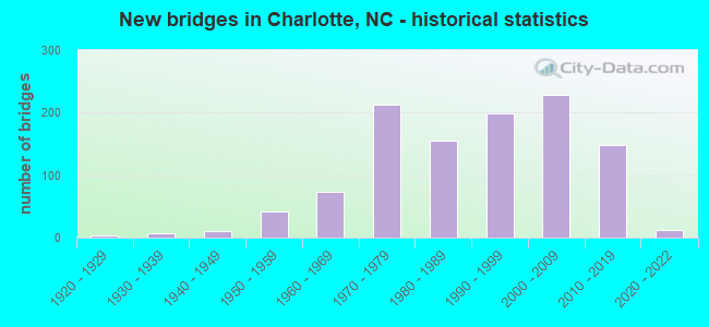
- New bridges - historical statistics
- 31920-1929
- 71930-1939
- 101940-1949
- 411950-1959
- 741960-1969
- 2131970-1979
- 1561980-1989
- 1981990-1999
- 2282000-2009
- 1482010-2019
- 122020-2022
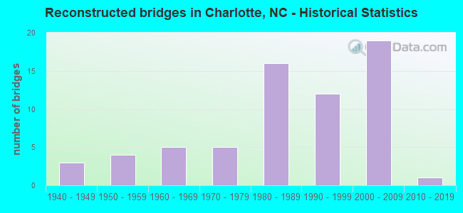
- Reconstructed bridges - Historical Statistics
- 31940-1949
- 41950-1959
- 51960-1969
- 51970-1979
- 161980-1989
- 121990-1999
- 192000-2009
- 12010-2019
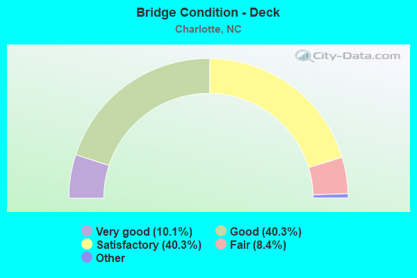
- Bridge Condition - Deck
- 10.1%Excellent
- 40.3%Very good
- 40.3%Good
- 8.4%Satisfactory
- 1.0%Fair
- 0.7%Poor
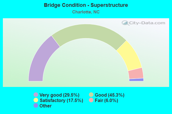
- Bridge Condition - Superstructure
- 29.5%Excellent
- 45.3%Very good
- 17.5%Good
- 6.0%Satisfactory
- 1.7%Fair
- 0.7%Poor
- 0.5%Serious
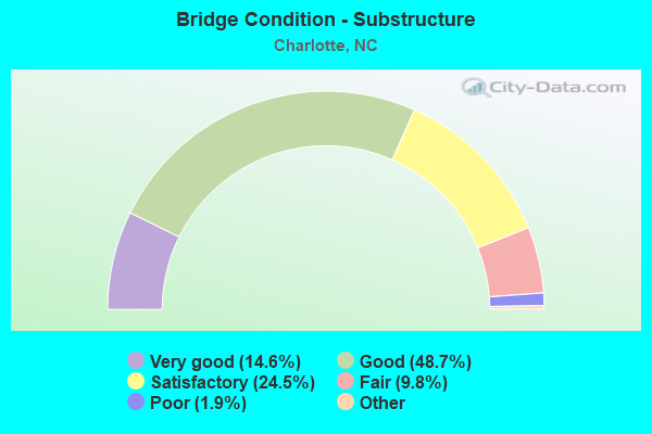
- Bridge Condition - Substructure
- 14.6%Excellent
- 48.7%Very good
- 24.5%Good
- 9.8%Satisfactory
- 1.9%Fair
- 0.5%Poor
- 0.2%Serious
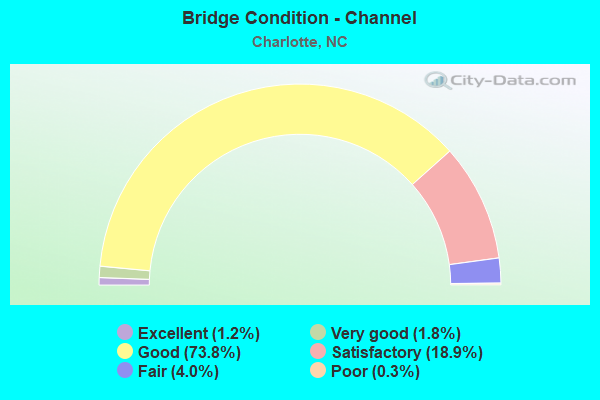
- Bridge Condition - Channel
- 1.2%Excellent
- 1.8%Very good
- 73.8%Good
- 18.9%Satisfactory
- 4.0%Fair
- 0.3%Poor
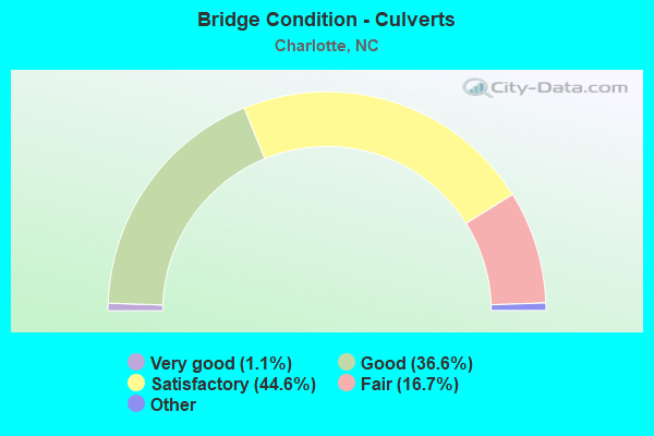
- Bridge Condition - Culverts
- 1.1%Excellent
- 36.6%Very good
- 44.6%Good
- 16.7%Satisfactory
- 1.1%Fair
- 0.5%Serious
Find on map >> Show street view
Structure Number: 1190436, Location: 300 FT N BELLE PLANE DR. (Lat: 35.243769, Lng: -80.751767), Route carried "on" structure: City street , Year Built: 1998, Status: Open, Structure Length: 0.79m (2.59ft), Average Daily Traffic: 15,000 (year 2012), Truck Traffic: 7%, Average Future Daily Traffic: 30,000 (year 2040), Design Load: HS 20+Mod, Features Intersected: BRIAR CREEK TRIBUTARY, Facility Carried by Structure: MILTON ROAD
Minimum Vertical Clearance: 30+ m (98+ ft), Kilometerpoint: 0.000, Lanes on structure: 5, Owner: City or Municipal Highway Agency, Approaching Roadway Width: 18.2m (59.7ft), Skew: 4 degrees, Material/Design: Concrete continuous, Design/Construction: Culvert, Number Of Spans In Main Unit: 2, Length of Maximum Span: 3.0m (9.8ft), Curb or Sidewalk Widths: Left: 1.5m (4.9ft), Right: 1.5m (4.9ft), Curb-To-Curb Width: 18.2m (59.7ft), Out-to-Out Width: 27.5m (90.2ft)
Condition: Channel: Good, Culverts: Satisfactory, Operating Rating: 82.5 metric tons, Method Used To Determine Operating Rating: Load Factor (LF), Inventory Rating: 48.9 metric tons, Method Used To Determine Inventory Rating: Load Factor (LF), Structural Evaluation: Equal to present minimum criteria, Deck Geometry: High priority of replacement, Waterway Adequacy: Better than present minimum criteria, Approach Roadway Alignment: Equal to present desirable criteria, Designated Inspection Frequency: Every 24 months, Inspection Date: April 2020
Find on map >> Show street view
Structure Number: 1190437, Location: 150 FT.N.JCT.BANKSTON PL. (Lat: 35.241233, Lng: -80.758328), Route carried "on" structure: City street , Year Built: 2003, Status: Open, Structure Length: 0.85m (2.79ft), Average Daily Traffic: 500 (year 1990), Truck Traffic: 7%, Average Future Daily Traffic: 1,000 (year 2040), Design Load: HS 20+Mod, Features Intersected: BRIAR CREEK TRIBUTARY, Facility Carried by Structure: GALWAY DRIVE
Minimum Vertical Clearance: 30+ m (98+ ft), Kilometerpoint: 0.000, Lanes on structure: 2, Owner: City or Municipal Highway Agency, Approaching Roadway Width: 8.8m (28.9ft), Skew: 3 degrees, Material/Design: Concrete continuous, Design/Construction: Culvert, Number Of Spans In Main Unit: 1, Length of Maximum Span: 7.3m (24.0ft)
Condition: Channel: Good, Culverts: Good, Operating Rating: 41.7 metric tons, Method Used To Determine Operating Rating: Field evaluation and documented engineering judgment, Inventory Rating: 32.6 metric tons, Method Used To Determine Inventory Rating: Field evaluation and documented engineering judgment, Structural Evaluation: Better than present minimum criteria, Waterway Adequacy: Equal to present minimum criteria, Approach Roadway Alignment: Equal to present desirable criteria, Designated Inspection Frequency: Every 24 months, Inspection Date: April 2020
Find on map >> Show street view
Structure Number: 1190438, Location: 0.4 MI.E.JCT.NC24 (Lat: 35.198864, Lng: -80.741283), Route carried "on" structure: City street , Year Built: 1975, Status: Open, Structure Length: 1.06m (3.48ft), Average Daily Traffic: 5,000 (year 1991), Truck Traffic: 7%, Average Future Daily Traffic: 10,000 (year 2040), Design Load: HS 20+Mod, Features Intersected: CAMPBELL CREEK, Facility Carried by Structure: EXECUTIVE CTR DR.
Minimum Vertical Clearance: 30+ m (98+ ft), Kilometerpoint: 0.000, Lanes on structure: 2, Owner: City or Municipal Highway Agency, Approaching Roadway Width: 12.1m (39.7ft), Skew: 2 degrees, Material/Design: Concrete continuous, Design/Construction: Culvert, Number Of Spans In Main Unit: 3, Length of Maximum Span: 3.0m (9.8ft)
Condition: Channel: Good, Culverts: Good, Operating Rating: 41.7 metric tons, Method Used To Determine Operating Rating: Field evaluation and documented engineering judgment, Inventory Rating: 32.6 metric tons, Method Used To Determine Inventory Rating: Field evaluation and documented engineering judgment, Structural Evaluation: Better than present minimum criteria, Waterway Adequacy: Better than present minimum criteria, Approach Roadway Alignment: Equal to present desirable criteria, Designated Inspection Frequency: Every 24 months, Inspection Date: April 2020
Find on map >> Show street view
Structure Number: 1190439, Location: .2 MI.N.JCT.ELM FOREST RD (Lat: 35.188903, Lng: -80.749989), Route carried "on" structure: City street , Year Built: 1965, Status: Posted for load, Structure Length: 1.37m (4.49ft), Average Daily Traffic: 630 (year 1991), Truck Traffic: 7%, Average Future Daily Traffic: 1,260 (year 2040), Design Load: H 15, Features Intersected: CAMPBELL CREEK TRIB., Facility Carried by Structure: REDDMAN ROAD
Minimum Vertical Clearance: 30+ m (98+ ft), Kilometerpoint: 0.000, Lanes on structure: 2, Owner: City or Municipal Highway Agency, Approaching Roadway Width: 8.8m (28.9ft), Material/Design: Prestressed concrete, Design/Construction: Slab, Number Of Spans In Main Unit: 3, Length of Maximum Span: 4.2m (13.8ft), Curb or Sidewalk Widths: Left: 1.2m (3.9ft), Right: 1.2m (3.9ft), Curb-To-Curb Width: 8.8m (28.9ft), Out-to-Out Width: 11.7m (38.4ft)
Condition: Deck: Good, Superstructure: Good, Substructure: Satisfactory, Channel: Good, Operating Rating: 49.8 metric tons, Method Used To Determine Operating Rating: Allowable Stress (AS), Inventory Rating: 20.8 metric tons, Method Used To Determine Inventory Rating: Allowable Stress (AS), Structural Evaluation: Somewhat better than minimum adequacy, Deck Geometry: Somewhat better than minimum adequacy, Waterway Adequacy: Better than present minimum criteria, Approach Roadway Alignment: Equal to present desirable criteria, Designated Inspection Frequency: Every 24 months, Inspection Date: May 2020, Deck Structure Type: Concrete Precast Panels, Wearing Surface/Protective System: Wearing Surface: Bituminous
Find on map >> Show street view
Structure Number: 1190441, Location: 0.3 MI.S.JCT.ROZZELLES RD (Lat: 35.272600, Lng: -80.898219), Route carried "on" structure: City street , Year Built: 1957, Status: Posted for load, Structure Length: 4.38m (14.37ft), Average Daily Traffic: 5,600 (year 2012), Truck Traffic: 7%, Average Future Daily Traffic: 11,200 (year 2040), Features Intersected: CSX RR, Facility Carried by Structure: HOVIS ROAD
Minimum Vertical Clearance: 30+ m (98+ ft), Kilometerpoint: 0.000, Lanes on structure: 2, Owner: City or Municipal Highway Agency, Approaching Roadway Width: 15.2m (49.9ft), Material/Design: Steel, Design/Construction: Stringer/Multi-beam, Number Of Spans In Main Unit: 3, Length of Maximum Span: 15.8m (51.8ft), Curb or Sidewalk Widths: Left: 0.9m (3.0ft), Right: 0.9m (3.0ft), Curb-To-Curb Width: 8.5m (27.9ft), Out-to-Out Width: 11.0m (36.1ft)
Condition: Deck: Satisfactory, Superstructure: Fair, Substructure: Fair, Operating Rating: 37.1 metric tons, Method Used To Determine Operating Rating: Load Factor (LF), Inventory Rating: 22.6 metric tons, Method Used To Determine Inventory Rating: Load Factor (LF), Structural Evaluation: Somewhat better than minimum adequacy, Deck Geometry: High priority of replacement, Underclear: Somewhat better than minimum adequacy, Approach Roadway Alignment: Equal to present desirable criteria, Bridge Posting: Required (Relationship of Operating Rating to Maximum Legal Load: 0.1 - 9.9% below), Designated Inspection Frequency: Every 24 months, Inspection Date: December 2020, Deck Structure Type: Concrete Cast-file-Place, Wearing Surface/Protective System: Wearing Surface: Bituminous
Find on map >> Show street view
Structure Number: 1190443, Location: 0.3MI.S.JCT.US29,74 (Lat: 35.224194, Lng: -80.911656), Route carried "on" structure: City street , Year Built: 1942, Status: Posted for load, Structure Length: 4.60m (15.09ft), Average Daily Traffic: 10,000 (year 2016), Truck Traffic: 7%, Average Future Daily Traffic: 20,000 (year 2040), Design Load: H 15, Features Intersected: SOUTHERN RAILROAD, Facility Carried by Structure: MORRIS FIELD DRIVE
Minimum Vertical Clearance: 30+ m (98+ ft), Kilometerpoint: 0.000, Lanes on structure: 2, Owner: City or Municipal Highway Agency, Approaching Roadway Width: 8.8m (28.9ft), Material/Design: Concrete, Design/Construction: Tee Beam, Number Of Spans In Main Unit: 3, Length of Maximum Span: 18.5m (60.7ft), Curb or Sidewalk Widths: Left: 0.6m (2.0ft), Right: 0.6m (2.0ft), Curb-To-Curb Width: 7.9m (25.9ft), Out-to-Out Width: 9.8m (32.2ft)
Condition: Deck: Fair, Superstructure: Fair, Substructure: Fair, Operating Rating: 20.8 metric tons, Method Used To Determine Operating Rating: Field evaluation and documented engineering judgment, Inventory Rating: 16.3 metric tons, Method Used To Determine Inventory Rating: Field evaluation and documented engineering judgment, Structural Evaluation: Meets minimum limits, Deck Geometry: High priority of replacement, Underclear: Better than present minimum criteria, Approach Roadway Alignment: Equal to present desirable criteria, Bridge Posting: Required (Relationship of Operating Rating to Maximum Legal Load: 30.0 - 39.9% below), Designated Inspection Frequency: Every 24 months, Inspection Date: October 2021, Deck Structure Type: Concrete Cast-file-Place, Wearing Surface/Protective System: Wearing Surface: Bituminous
Find on map >> Show street view
Structure Number: 1190444, Location: 0.1 MI.E.NORTHPOINTE IND. (Lat: 35.276039, Lng: -80.867003), Route carried "on" structure: City street , Year Built: 1966, Status: Open, Structure Length: 1.40m (4.59ft), Average Daily Traffic: 6,300 (year 2014), Truck Traffic: 7%, Average Future Daily Traffic: 12,600 (year 2040), Design Load: HS 20+Mod, Features Intersected: STEWART CREEK, Facility Carried by Structure: HOSKINS ROAD
Minimum Vertical Clearance: 30+ m (98+ ft), Kilometerpoint: 0.000, Lanes on structure: 2, Owner: City or Municipal Highway Agency, Approaching Roadway Width: 8.2m (26.9ft), Skew: 3 degrees, Material/Design: Concrete continuous, Design/Construction: Culvert, Number Of Spans In Main Unit: 3, Length of Maximum Span: 3.6m (11.8ft)
Condition: Channel: Good, Culverts: Good, Operating Rating: 79.8 metric tons, Method Used To Determine Operating Rating: Load and Resistance Factor (LRFR), Inventory Rating: 59.8 metric tons, Method Used To Determine Inventory Rating: Load and Resistance Factor (LRFR), Structural Evaluation: Better than present minimum criteria, Waterway Adequacy: Better than present minimum criteria, Approach Roadway Alignment: Equal to present desirable criteria, Designated Inspection Frequency: Every 24 months, Inspection Date: May 2020
Find on map >> Show street view
Structure Number: 1190445, Location: .04 MI.W.JCT.IDLEBROOK RD (Lat: 35.186686, Lng: -80.736575), Route carried "on" structure: City street , Year Built: 1991, Status: Open, Structure Length: 1.28m (4.20ft), Average Daily Traffic: 23,000 (year 2012), Truck Traffic: 7%, Average Future Daily Traffic: 46,000 (year 2040), Design Load: HS 20+Mod, Features Intersected: CAMPBELL CREEK, Facility Carried by Structure: IDLEWILD ROAD
Minimum Vertical Clearance: 30+ m (98+ ft), Kilometerpoint: 0.000, Lanes on structure: 4, Owner: City or Municipal Highway Agency, Approaching Roadway Width: 14.6m (47.9ft), Material/Design: Concrete continuous, Design/Construction: Culvert, Number Of Spans In Main Unit: 4, Length of Maximum Span: 3.0m (9.8ft), Curb or Sidewalk Widths: Left: 1.6m (5.2ft), Right: 1.6m (5.2ft), Curb-To-Curb Width: 14.6m (47.9ft), Out-to-Out Width: 19.0m (62.3ft)
Condition: Channel: Good, Culverts: Satisfactory, Operating Rating: 41.7 metric tons, Method Used To Determine Operating Rating: Field evaluation and documented engineering judgment, Inventory Rating: 32.6 metric tons, Method Used To Determine Inventory Rating: Field evaluation and documented engineering judgment, Structural Evaluation: Equal to present minimum criteria, Deck Geometry: High priority of replacement, Waterway Adequacy: Better than present minimum criteria, Approach Roadway Alignment: Equal to present desirable criteria, Designated Inspection Frequency: Every 24 months, Inspection Date: April 2020
Find on map >> Show street view
Structure Number: 1190446, Location: 200'N.JCT. SARDIS RD. (Lat: 35.133089, Lng: -80.761606), Route carried "on" structure: City street , Year Built: 1991, Status: Open, Structure Length: 1.03m (3.38ft), Average Daily Traffic: 13,000 (year 2012), Truck Traffic: 7%, Average Future Daily Traffic: 26,000 (year 2040), Design Load: HS 20+Mod, Features Intersected: SARDIS BRANCH, Facility Carried by Structure: SARDIS ROAD NORTH
Minimum Vertical Clearance: 30+ m (98+ ft), Kilometerpoint: 0.000, Lanes on structure: 3, Owner: City or Municipal Highway Agency, Approaching Roadway Width: 11.2m (36.7ft), Material/Design: Concrete continuous, Design/Construction: Culvert, Number Of Spans In Main Unit: 3, Length of Maximum Span: 3.3m (10.8ft), Curb or Sidewalk Widths: Left: 0.0m, Right: 1.9m (6.2ft), Curb-To-Curb Width: 11.2m (36.7ft), Out-to-Out Width: 20.1m (65.9ft)
Condition: Channel: Good, Culverts: Good, Operating Rating: 45.3 metric tons, Method Used To Determine Operating Rating: Load and Resistance Factor (LRFR), Inventory Rating: 35.3 metric tons, Method Used To Determine Inventory Rating: Load and Resistance Factor (LRFR), Structural Evaluation: Better than present minimum criteria, Deck Geometry: High priority of replacement, Waterway Adequacy: Better than present minimum criteria, Approach Roadway Alignment: Equal to present desirable criteria, Designated Inspection Frequency: Every 24 months, Inspection Date: March 2020
Find on map >> Show street view
Structure Number: 1190447, Location: 200'E.JCT.PICARDY PLACE (Lat: 35.173942, Lng: -80.833108), Route carried "on" structure: City street , Year Built: 1950, Status: Open, Structure Length: 1.09m (3.58ft), Average Daily Traffic: 6,700 (year 2012), Truck Traffic: 7%, Average Future Daily Traffic: 13,400 (year 2040), Design Load: HS 20+Mod, Features Intersected: BRIER CREEK, Facility Carried by Structure: COLONY ROAD
Minimum Vertical Clearance: 30+ m (98+ ft), Kilometerpoint: 0.000, Lanes on structure: 2, Owner: City or Municipal Highway Agency, Approaching Roadway Width: 10.0m (32.8ft), Skew: 2 degrees, Material/Design: Concrete, Design/Construction: Culvert, Number Of Spans In Main Unit: 1, Length of Maximum Span: 10.3m (33.8ft)
Condition: Channel: Satisfactory, Culverts: Satisfactory, Operating Rating: 41.7 metric tons, Method Used To Determine Operating Rating: Field evaluation and documented engineering judgment, Inventory Rating: 32.6 metric tons, Method Used To Determine Inventory Rating: Field evaluation and documented engineering judgment, Structural Evaluation: Equal to present minimum criteria, Waterway Adequacy: Better than present minimum criteria, Approach Roadway Alignment: Equal to present desirable criteria, Designated Inspection Frequency: Every 24 months, Inspection Date: March 2020
Find on map >> Show street view
Structure Number: 1190448, Location: 0.1 MI. S. JCT. 16N (Lat: 35.216967, Lng: -80.835325), Route carried "on" structure: Interstate 277, Year Built: 1981, Status: Open, Structure Length: 4.78m (15.68ft), Average Daily Traffic: 51,000 (year 2019), Truck Traffic: 16%, Average Future Daily Traffic: 102,000 (year 2040), Design Load: HS 20+Mod, Features Intersected: NC16S
Minimum Vertical Clearance: 30+ m (98+ ft), Kilometerpoint: 0.609, Lanes on structure: 7, Lanes under structure: 4, Base Highway Network: Yes (Inventory Route: 1, Subroute: 77), Owner: State Highway Agency, Approaching Roadway Width: 32.6m (107.0ft), Skew: 30 degrees, Material/Design: Steel continuous, Design/Construction: Stringer/Multi-beam, Number Of Spans In Main Unit: 3, Length of Maximum Span: 26.5m (86.9ft), Curb-To-Curb Width: 33.5m (109.9ft), Out-to-Out Width: 34.7m (113.8ft)
Condition: Deck: Good, Superstructure: Very good, Substructure: Good, Operating Rating: 89.8 metric tons, Method Used To Determine Operating Rating: Load Factor (LF), Inventory Rating: 60.7 metric tons, Method Used To Determine Inventory Rating: Load Factor (LF), Structural Evaluation: Better than present minimum criteria, Deck Geometry: Superior to present desirable criteria, Underclear: Equal to present minimum criteria, Approach Roadway Alignment: Equal to present desirable criteria, Designated Inspection Frequency: Every 24 months, Inspection Date: May 2021, Deck Structure Type: Concrete Cast-file-Place, Wearing Surface/Protective System: Wearing Surface: Monolithic Concrete
Find on map >> Show street view
Structure Number: 1190449, Location: 0.1 MI. N. JCT.NC16S (Lat: 35.217897, Lng: -80.834389), Route carried "on" structure: Interstate 277, Year Built: 1981, Status: Open, Structure Length: 4.78m (15.68ft), Average Daily Traffic: 51,000 (year 2019), Truck Traffic: 16%, Average Future Daily Traffic: 102,000 (year 2040), Design Load: HS 20+Mod, Features Intersected: NC16N
Minimum Vertical Clearance: 30+ m (98+ ft), Kilometerpoint: 0.640, Lanes on structure: 7, Lanes under structure: 4, Base Highway Network: Yes (Inventory Route: 1, Subroute: 77), Owner: State Highway Agency, Approaching Roadway Width: 33.5m (109.9ft), Skew: 30 degrees, Material/Design: Steel continuous, Design/Construction: Stringer/Multi-beam, Number Of Spans In Main Unit: 3, Length of Maximum Span: 26.5m (86.9ft), Curb-To-Curb Width: 32.3m (106.0ft), Out-to-Out Width: 33.8m (110.9ft)
Condition: Deck: Good, Superstructure: Very good, Substructure: Good, Operating Rating: 89.8 metric tons, Method Used To Determine Operating Rating: Load Factor (LF), Inventory Rating: 60.7 metric tons, Method Used To Determine Inventory Rating: Load Factor (LF), Structural Evaluation: Better than present minimum criteria, Deck Geometry: Better than present minimum criteria, Underclear: Equal to present minimum criteria, Approach Roadway Alignment: Equal to present desirable criteria, Designated Inspection Frequency: Every 24 months, Inspection Date: May 2021, Deck Structure Type: Concrete Cast-file-Place, Wearing Surface/Protective System: Wearing Surface: Monolithic Concrete
Find on map >> Show street view
Structure Number: 119045, Location: 0.1 MI. N. JCT. NC16N (Lat: 35.219053, Lng: -80.833211), Route carried "on" structure: Interstate 277, Year Built: 1981, Status: Open, Structure Length: 4.23m (13.88ft), Average Daily Traffic: 102,000 (year 2019), Truck Traffic: 16%, Average Future Daily Traffic: 204,000 (year 2040), Design Load: HS 20+Mod, Features Intersected: ELIZABETH AVE.
Minimum Vertical Clearance: 30+ m (98+ ft), Kilometerpoint: 0.670, Lanes on structure: 7, Lanes under structure: 2, Base Highway Network: Yes (Inventory Route: 1, Subroute: 77), Owner: State Highway Agency, Approaching Roadway Width: 39.6m (129.9ft), Skew: 30 degrees, Material/Design: Steel, Design/Construction: Stringer/Multi-beam, Number Of Spans In Main Unit: 3, Length of Maximum Span: 21.3m (69.9ft), Curb or Sidewalk Widths: Left: 0.5m (1.6ft), Right: 0.5m (1.6ft), Curb-To-Curb Width: 39.7m (130.2ft), Out-to-Out Width: 41.5m (136.2ft)
Condition: Deck: Good, Superstructure: Good, Substructure: Good, Operating Rating: 82.5 metric tons, Method Used To Determine Operating Rating: Load Factor (LF), Inventory Rating: 48.9 metric tons, Method Used To Determine Inventory Rating: Load Factor (LF), Structural Evaluation: Better than present minimum criteria, Deck Geometry: Superior to present desirable criteria, Underclear: High priority of corrective action, Approach Roadway Alignment: Equal to present desirable criteria, Designated Inspection Frequency: Every 24 months, Inspection Date: May 2021, Deck Structure Type: Concrete Cast-file-Place, Wearing Surface/Protective System: Wearing Surface: Monolithic Concrete
Find on map >> Show street view
Structure Number: 1190451, Location: 0.2 MI. E. JCT. NC16 (Lat: 35.220322, Lng: -80.832061), Route carried "on" structure: Ramp US 74, Year Built: 1981, Status: Open, Structure Length: 4.26m (13.98ft), Average Daily Traffic: 10,700 (year 2016), Truck Traffic: 12%, Average Future Daily Traffic: 21,400 (year 2040), Design Load: HS 20+Mod, Features Intersected: 5TH STREET
Minimum Vertical Clearance: 30+ m (98+ ft), Kilometerpoint: 0.701, Lanes on structure: 2, Lanes under structure: 2, Owner: State Highway Agency, Approaching Roadway Width: 8.5m (27.9ft), Material/Design: Steel, Design/Construction: Stringer/Multi-beam, Number Of Spans In Main Unit: 3, Length of Maximum Span: 14.6m (47.9ft), Curb or Sidewalk Widths: Left: 0.2m (0.7ft), Right: 0.2m (0.7ft), Curb-To-Curb Width: 8.5m (27.9ft), Out-to-Out Width: 9.7m (31.8ft)
Condition: Deck: Good, Superstructure: Good, Substructure: Good, Operating Rating: 89.8 metric tons, Method Used To Determine Operating Rating: Load Factor (LF), Inventory Rating: 68.9 metric tons, Method Used To Determine Inventory Rating: Load Factor (LF), Structural Evaluation: Better than present minimum criteria, Deck Geometry: High priority of corrective action, Underclear: High priority of corrective action, Approach Roadway Alignment: Equal to present desirable criteria, Designated Inspection Frequency: Every 24 months, Inspection Date: May 2021, Deck Structure Type: Concrete Cast-file-Place, Wearing Surface/Protective System: Wearing Surface: Monolithic Concrete
Find on map >> Show street view
Structure Number: 1190452, Location: 0.1 MI. S. JCT. NC27 (Lat: 35.220269, Lng: -80.831878), Route carried "on" structure: Interstate 277, Year Built: 1981, Status: Open, Structure Length: 4.81m (15.78ft), Average Daily Traffic: 102,000 (year 2019), Truck Traffic: 16%, Average Future Daily Traffic: 204,000 (year 2040), Design Load: HS 20+Mod, Features Intersected: 5TH STREET
Minimum Vertical Clearance: 30+ m (98+ ft), Kilometerpoint: 0.701, Lanes on structure: 6, Lanes under structure: 2, Base Highway Network: Yes (Inventory Route: 1, Subroute: 77), Owner: State Highway Agency, Approaching Roadway Width: 30.1m (98.8ft), Skew: 33 degrees, Material/Design: Steel, Design/Construction: Stringer/Multi-beam, Number Of Spans In Main Unit: 3, Length of Maximum Span: 17.3m (56.8ft), Curb or Sidewalk Widths: Left: 0.5m (1.6ft), Right: 0.5m (1.6ft), Curb-To-Curb Width: 29.8m (97.8ft), Out-to-Out Width: 31.6m (103.7ft)
Condition: Deck: Good, Superstructure: Satisfactory, Substructure: Good, Operating Rating: 53.5 metric tons, Method Used To Determine Operating Rating: Load Factor (LF), Inventory Rating: 31.7 metric tons, Method Used To Determine Inventory Rating: Load Factor (LF), Structural Evaluation: Equal to present minimum criteria, Deck Geometry: Superior to present desirable criteria, Underclear: Equal to present minimum criteria, Approach Roadway Alignment: Equal to present desirable criteria, Designated Inspection Frequency: Every 24 months, Inspection Date: May 2021, Deck Structure Type: Concrete Cast-file-Place, Wearing Surface/Protective System: Wearing Surface: Monolithic Concrete
Find on map >> Show street view
Structure Number: 1190454, Location: 0.6 MI. N. JCT. SR2095 (Lat: 35.294919, Lng: -80.850864), Route carried "on" structure: Interstate 77, Year Built: 1971, Status: Open, Structure Length: 0.64m (2.10ft), Average Daily Traffic: 118,000 (year 2013), Truck Traffic: 16%, Average Future Daily Traffic: 236,000 (year 2040), Design Load: HS 20+Mod, Features Intersected: UT TO IRWIN CREEK
Minimum Vertical Clearance: 30+ m (98+ ft), Kilometerpoint: 4.419, Lanes on structure: 8, Base Highway Network: Yes (Inventory Route: 1, Subroute: 77), Owner: State Highway Agency, Approaching Roadway Width: 55.7m (182.7ft), Skew: 24 degrees, Material/Design: Concrete continuous, Design/Construction: Culvert, Number Of Spans In Main Unit: 2, Length of Maximum Span: 2.1m (6.9ft)
Condition: Channel: Good, Culverts: Satisfactory, Operating Rating: 89.8 metric tons, Method Used To Determine Operating Rating: Load and Resistance Factor (LRFR), Inventory Rating: 70.7 metric tons, Method Used To Determine Inventory Rating: Load and Resistance Factor (LRFR), Structural Evaluation: Equal to present minimum criteria, Waterway Adequacy: Better than present minimum criteria, Approach Roadway Alignment: Equal to present desirable criteria, Designated Inspection Frequency: Every 24 months, Inspection Date: July 2020
Find on map >> Show street view
Structure Number: 1190455, Location: 0.3 MI. S. JCT. SR1490 (Lat: 35.215428, Lng: -80.922950), Route carried "on" structure: State highway 5901, Year Built: 1960, Year Reconstructed: 1981, Status: Open, Structure Length: 1.12m (3.67ft), Average Daily Traffic: 55,000 (year 2018), Truck Traffic: 12%, Average Future Daily Traffic: 110,000 (year 2040), Design Load: HS 20+Mod, Features Intersected: TAGGART CREEK
Minimum Vertical Clearance: 30+ m (98+ ft), Kilometerpoint: 0.000, Lanes on structure: 4, Base Highway Network: Yes (Inventory Route: 2, Subroute: 21), Owner: State Highway Agency, Approaching Roadway Width: 23.1m (75.8ft), Skew: 25 degrees, Material/Design: Concrete continuous, Design/Construction: Culvert, Number Of Spans In Main Unit: 2, Length of Maximum Span: 3.6m (11.8ft)
Condition: Channel: Satisfactory, Culverts: Fair, Operating Rating: 41.7 metric tons, Method Used To Determine Operating Rating: Field evaluation and documented engineering judgment, Inventory Rating: 32.6 metric tons, Method Used To Determine Inventory Rating: Field evaluation and documented engineering judgment, Structural Evaluation: Somewhat better than minimum adequacy, Waterway Adequacy: Better than present minimum criteria, Approach Roadway Alignment: Equal to present desirable criteria, Designated Inspection Frequency: Every 24 months, Inspection Date: November 2021
Find on map >> Show street view
Structure Number: 1190456, Location: 1.4 MI. S. JCT. I85 (Lat: 35.219458, Lng: -80.923572), Route carried "on" structure: State highway 5901, Year Built: 1981, Status: Open, Structure Length: 0.79m (2.59ft), Average Daily Traffic: 51,000 (year 2015), Truck Traffic: 12%, Average Future Daily Traffic: 102,000 (year 2040), Design Load: HS 20+Mod, Features Intersected: TAGGART CREEK
Minimum Vertical Clearance: 30+ m (98+ ft), Kilometerpoint: 0.000, Lanes on structure: 4, Base Highway Network: Yes (Inventory Route: 2, Subroute: 21), Owner: State Highway Agency, Approaching Roadway Width: 23.1m (75.8ft), Skew: 21 degrees, Material/Design: Concrete continuous, Design/Construction: Culvert, Number Of Spans In Main Unit: 2, Length of Maximum Span: 3.6m (11.8ft)
Condition: Channel: Satisfactory, Culverts: Fair, Operating Rating: 41.7 metric tons, Method Used To Determine Operating Rating: Load and Resistance Factor (LRFR), Inventory Rating: 31.7 metric tons, Method Used To Determine Inventory Rating: Load and Resistance Factor (LRFR), Structural Evaluation: Somewhat better than minimum adequacy, Waterway Adequacy: Better than present minimum criteria, Approach Roadway Alignment: Equal to present desirable criteria, Designated Inspection Frequency: Every 24 months, Inspection Date: November 2021
Find on map >> Show street view
Structure Number: 1190457, Location: 1.3 MI. S. JCT. I85 (Lat: 35.221458, Lng: -80.922286), Route carried "on" structure: Ramp State highway 5901, Year Built: 1981, Status: Open, Structure Length: 0.76m (2.49ft), Average Daily Traffic: 12,000 (year 2018), Truck Traffic: 12%, Average Future Daily Traffic: 24,000 (year 2040), Design Load: HS 20+Mod, Features Intersected: TAGGART CREEK
Minimum Vertical Clearance: 30+ m (98+ ft), Kilometerpoint: 0.000, Lanes on structure: 2, Owner: State Highway Agency, Approaching Roadway Width: 9.7m (31.8ft), Material/Design: Concrete continuous, Design/Construction: Culvert, Number Of Spans In Main Unit: 2, Length of Maximum Span: 3.6m (11.8ft)
Condition: Channel: Satisfactory, Culverts: Fair, Operating Rating: 89.8 metric tons, Method Used To Determine Operating Rating: Load and Resistance Factor (LRFR), Inventory Rating: 89.8 metric tons, Method Used To Determine Inventory Rating: Load and Resistance Factor (LRFR), Structural Evaluation: Somewhat better than minimum adequacy, Waterway Adequacy: Better than present minimum criteria, Approach Roadway Alignment: Equal to present desirable criteria, Designated Inspection Frequency: Every 24 months, Inspection Date: November 2021
Find on map >> Show street view
Structure Number: 1190459, Location: 0.2 MI. N. JCT. SR1191 (Lat: 35.231917, Lng: -80.923356), Route carried "on" structure: State highway 5901, Year Built: 1981, Status: Open, Structure Length: 5.88m (19.29ft), Average Daily Traffic: 20,000 (year 2012), Truck Traffic: 12%, Average Future Daily Traffic: 40,000 (year 2040), Design Load: HS 20+Mod, Features Intersected: US29 & US74
Minimum Vertical Clearance: 30+ m (98+ ft), Kilometerpoint: 0.000, Lanes on structure: 2, Lanes under structure: 6, Owner: State Highway Agency, Approaching Roadway Width: 11.5m (37.7ft), Skew: 10 degrees, Material/Design: Steel, Design/Construction: Stringer/Multi-beam, Number Of Spans In Main Unit: 3, Length of Maximum Span: 35.3m (115.8ft), Curb-To-Curb Width: 12.1m (39.7ft), Out-to-Out Width: 12.9m (42.3ft)
Condition: Deck: Satisfactory, Superstructure: Fair, Substructure: Satisfactory, Operating Rating: 89.8 metric tons, Method Used To Determine Operating Rating: Load Factor (LF), Inventory Rating: 57.1 metric tons, Method Used To Determine Inventory Rating: Load Factor (LF), Structural Evaluation: Somewhat better than minimum adequacy, Deck Geometry: Better than present minimum criteria, Underclear: Equal to present minimum criteria, Approach Roadway Alignment: Equal to present desirable criteria, Designated Inspection Frequency: Every 24 months, Inspection Date: September 2020, Deck Structure Type: Concrete Cast-file-Place, Wearing Surface/Protective System: Wearing Surface: Monolithic Concrete
Find on map >> Show street view
Structure Number: 119046, Location: 0.2 MI. N. JCT. SR1191 (Lat: 35.232011, Lng: -80.923636), Route carried "on" structure: State highway 5901, Year Built: 1981, Status: Open, Structure Length: 5.69m (18.67ft), Average Daily Traffic: 23,000 (year 2014), Truck Traffic: 12%, Average Future Daily Traffic: 46,000 (year 2040), Design Load: HS 20+Mod, Features Intersected: US29 & US74
Minimum Vertical Clearance: 30+ m (98+ ft), Kilometerpoint: 0.000, Lanes on structure: 2, Lanes under structure: 6, Base Highway Network: Yes (Inventory Route: 2, Subroute: 21), Owner: State Highway Agency, Approaching Roadway Width: 12.1m (39.7ft), Skew: 10 degrees, Material/Design: Steel, Design/Construction: Stringer/Multi-beam, Number Of Spans In Main Unit: 3, Length of Maximum Span: 35.0m (114.8ft), Curb-To-Curb Width: 12.1m (39.7ft), Out-to-Out Width: 13.0m (42.7ft)
Condition: Deck: Satisfactory, Superstructure: Satisfactory, Substructure: Satisfactory, Operating Rating: 89.8 metric tons, Method Used To Determine Operating Rating: Load Factor (LF), Inventory Rating: 59.8 metric tons, Method Used To Determine Inventory Rating: Load Factor (LF), Structural Evaluation: Equal to present minimum criteria, Deck Geometry: Equal to present minimum criteria, Underclear: Equal to present minimum criteria, Approach Roadway Alignment: Equal to present desirable criteria, Designated Inspection Frequency: Every 24 months, Inspection Date: September 2020, Deck Structure Type: Concrete Cast-file-Place, Wearing Surface/Protective System: Wearing Surface: Monolithic Concrete
Find on map >> Show street view
Structure Number: 1190461, Location: 0.05 MI. S. JCT. SR1180 (Lat: 35.196644, Lng: -80.947603), Route carried "on" structure: State highway 160, Year Built: 1982, Status: Open, Structure Length: 1.40m (4.59ft), Average Daily Traffic: 16,500 (year 2018), Truck Traffic: 12%, Average Future Daily Traffic: 33,000 (year 2040), Design Load: HS 20+Mod, Features Intersected: COFFEY CREEK
Minimum Vertical Clearance: 30+ m (98+ ft), Kilometerpoint: 0.000, Lanes on structure: 2, Base Highway Network: Yes (Inventory Route: 3, Subroute: 60), Owner: State Highway Agency, Approaching Roadway Width: 7.3m (24.0ft), Skew: 3 degrees, Material/Design: Concrete continuous, Design/Construction: Culvert, Number Of Spans In Main Unit: 3, Length of Maximum Span: 3.6m (11.8ft)
Condition: Channel: Fair, Culverts: Satisfactory, Operating Rating: 46.2 metric tons, Method Used To Determine Operating Rating: Load and Resistance Factor (LRFR), Inventory Rating: 35.3 metric tons, Method Used To Determine Inventory Rating: Load and Resistance Factor (LRFR), Structural Evaluation: Equal to present minimum criteria, Waterway Adequacy: Better than present minimum criteria, Approach Roadway Alignment: Equal to present desirable criteria, Designated Inspection Frequency: Every 24 months, Inspection Date: September 2021
Find on map >> Show street view
Structure Number: 1190463, Location: 0.5 MI. W. JCT. SR5901 (Lat: 35.227322, Lng: -80.930208), Route carried "on" structure: City street , Year Built: 1983, Status: Open, Structure Length: 8.96m (29.40ft), Average Daily Traffic: 7,100 (year 2016), Truck Traffic: 7%, Average Future Daily Traffic: 14,200 (year 2040), Design Load: HS 20+Mod, Features Intersected: SR1490, Facility Carried by Structure: OLD DOWD ROAD
Minimum Vertical Clearance: 30+ m (98+ ft), Kilometerpoint: 0.000, Lanes on structure: 2, Lanes under structure: 4, Owner: State Highway Agency, Approaching Roadway Width: 8.5m (27.9ft), Skew: 2 degrees, Material/Design: Steel, Design/Construction: Stringer/Multi-beam, Number Of Spans In Main Unit: 4, Length of Maximum Span: 32.3m (106.0ft), Curb-To-Curb Width: 12.1m (39.7ft), Out-to-Out Width: 13.0m (42.7ft)
Condition: Deck: Satisfactory, Superstructure: Satisfactory, Substructure: Satisfactory, Operating Rating: 88.9 metric tons, Method Used To Determine Operating Rating: Load Factor (LF), Inventory Rating: 53.5 metric tons, Method Used To Determine Inventory Rating: Load Factor (LF), Structural Evaluation: Equal to present minimum criteria, Deck Geometry: Somewhat better than minimum adequacy, Underclear: Equal to present minimum criteria, Approach Roadway Alignment: Equal to present desirable criteria, Designated Inspection Frequency: Every 24 months, Inspection Date: November 2021, Deck Structure Type: Concrete Cast-file-Place, Wearing Surface/Protective System: Wearing Surface: Monolithic Concrete
Find on map >> Show street view
Structure Number: 1190464, Location: 0.2 MI. S. JCT. US74 (Lat: 35.230128, Lng: -80.934128), Route carried "on" structure: City street , Year Built: 1983, Status: Open, Structure Length: 7.46m (24.48ft), Average Daily Traffic: 5,400 (year 2016), Truck Traffic: 7%, Average Future Daily Traffic: 10,800 (year 2040), Design Load: HS 20+Mod, Features Intersected: SR1490, Facility Carried by Structure: HARLEE AVE
Minimum Vertical Clearance: 30+ m (98+ ft), Kilometerpoint: 0.000, Lanes on structure: 2, Lanes under structure: 4, Owner: State Highway Agency, Approaching Roadway Width: 8.5m (27.9ft), Skew: 1 degrees, Material/Design: Steel, Design/Construction: Stringer/Multi-beam, Number Of Spans In Main Unit: 2, Length of Maximum Span: 38.1m (125.0ft), Curb-To-Curb Width: 12.1m (39.7ft), Out-to-Out Width: 13.0m (42.7ft)
Condition: Deck: Satisfactory, Superstructure: Very good, Substructure: Good, Operating Rating: 89.8 metric tons, Method Used To Determine Operating Rating: Load Factor (LF), Inventory Rating: 68.0 metric tons, Method Used To Determine Inventory Rating: Load Factor (LF), Structural Evaluation: Better than present minimum criteria, Deck Geometry: Somewhat better than minimum adequacy, Underclear: Meets minimum limits, Approach Roadway Alignment: Equal to present desirable criteria, Designated Inspection Frequency: Every 24 months, Inspection Date: November 2021, Deck Structure Type: Concrete Cast-file-Place, Wearing Surface/Protective System: Wearing Surface: Monolithic Concrete
Find on map >> Show street view
Structure Number: 1190465, Location: 0.5 MI. S. JCT. US29,US74 (Lat: 35.227672, Lng: -80.942703), Route carried "on" structure: State highway 1490, Year Built: 1983, Status: Open, Structure Length: 6.18m (20.28ft), Average Daily Traffic: 32,000 (year 2012), Truck Traffic: 12%, Average Future Daily Traffic: 64,000 (year 2025), Design Load: HS 20+Mod, Features Intersected: SOUTHERN RR, Facility Carried by Structure: JOSH BIRMINGHAM PA
Minimum Vertical Clearance: 30+ m (98+ ft), Kilometerpoint: 0.000, Lanes on structure: 4, Base Highway Network: Yes (Inventory Route: 3, Subroute: 90), Owner: City or Municipal Highway Agency, Approaching Roadway Width: 20.4m (66.9ft), Skew: 20 degrees, Material/Design: Steel, Design/Construction: Stringer/Multi-beam, Number Of Spans In Main Unit: 3, Length of Maximum Span: 30.7m (100.7ft), Curb-To-Curb Width: 20.7m (67.9ft), Out-to-Out Width: 21.5m (70.5ft)
Condition: Deck: Satisfactory, Superstructure: Good, Substructure: Fair, Operating Rating: 86.1 metric tons, Method Used To Determine Operating Rating: Load Factor (LF), Inventory Rating: 51.7 metric tons, Method Used To Determine Inventory Rating: Load Factor (LF), Structural Evaluation: Somewhat better than minimum adequacy, Deck Geometry: Equal to present minimum criteria, Underclear: Equal to present minimum criteria, Approach Roadway Alignment: Equal to present desirable criteria, Designated Inspection Frequency: Every 24 months, Inspection Date: November 2021, Deck Structure Type: Concrete Cast-file-Place, Wearing Surface/Protective System: Wearing Surface: Monolithic Concrete
Find on map >> Show street view
Structure Number: 1190474, Location: 0.6 MI. E. JCT. SR2480 (Lat: 35.325572, Lng: -80.783417), Route carried "on" structure: State highway 24, Year Built: 1984, Year Reconstructed: 1995, Status: Open, Structure Length: 1.64m (5.38ft), Average Daily Traffic: 36,000 (year 2018), Truck Traffic: 12%, Average Future Daily Traffic: 72,000 (year 2040), Design Load: HS 20+Mod, Features Intersected: MALLARD CREEK
Minimum Vertical Clearance: 30+ m (98+ ft), Kilometerpoint: 0.000, Lanes on structure: 4, Owner: State Highway Agency, Approaching Roadway Width: 19.5m (64.0ft), Material/Design: Concrete continuous, Design/Construction: Culvert, Number Of Spans In Main Unit: 4, Length of Maximum Span: 3.9m (12.8ft)
Condition: Channel: Satisfactory, Culverts: Satisfactory, Operating Rating: 64.4 metric tons, Method Used To Determine Operating Rating: Load and Resistance Factor (LRFR), Inventory Rating: 48.9 metric tons, Method Used To Determine Inventory Rating: Load and Resistance Factor (LRFR), Structural Evaluation: Equal to present minimum criteria, Waterway Adequacy: Equal to present desirable criteria, Approach Roadway Alignment: Equal to present desirable criteria, Designated Inspection Frequency: Every 24 months, Inspection Date: June 2021
Find on map >> Show street view
Structure Number: 1190475, Location: 0.25 MI.S.JCT.SR3816 (Lat: 35.205631, Lng: -80.836853), Route carried "on" structure: State highway 3815, Year Built: 1945, Year Reconstructed: 1963, Status: Open, Structure Length: 1.06m (3.48ft), Average Daily Traffic: 22,000 (year 2012), Truck Traffic: 6%, Average Future Daily Traffic: 44,000 (year 2040), Design Load: H 15, Features Intersected: LITTLE SUGAR CREEK
Minimum Vertical Clearance: 30+ m (98+ ft), Kilometerpoint: 0.000, Lanes on structure: 4, Owner: State Highway Agency, Approaching Roadway Width: 14.3m (46.9ft), Skew: 3 degrees, Material/Design: Concrete, Design/Construction: Arch - Deck, Number Of Spans In Main Unit: 1, Length of Maximum Span: 10.0m (32.8ft), Curb or Sidewalk Widths: Left: 1.5m (4.9ft), Right: 1.9m (6.2ft), Curb-To-Curb Width: 15.1m (49.5ft), Out-to-Out Width: 19.3m (63.3ft)
Condition: Deck: Satisfactory, Superstructure: Fair, Substructure: Satisfactory, Channel: Good, Operating Rating: 31.7 metric tons, Method Used To Determine Operating Rating: Field evaluation and documented engineering judgment, Inventory Rating: 24.4 metric tons, Method Used To Determine Inventory Rating: Field evaluation and documented engineering judgment, Structural Evaluation: Somewhat better than minimum adequacy, Deck Geometry: High priority of corrective action, Waterway Adequacy: Better than present minimum criteria, Approach Roadway Alignment: Equal to present desirable criteria, Designated Inspection Frequency: Every 24 months, Inspection Date: July 2020, Deck Structure Type: Concrete Cast-file-Place, Wearing Surface/Protective System: Wearing Surface: Bituminous
Find on map >> Show street view
Structure Number: 1190477, Location: 0.1MI.N.JCT.GRAHAM PKWY. (Lat: 35.188706, Lng: -80.904222), Route carried "on" structure: City street , Year Built: 1957, Status: Posted for load, Structure Length: 4.29m (14.07ft), Average Daily Traffic: 3,400 (year 1993), Truck Traffic: 7%, Average Future Daily Traffic: 6,800 (year 2040), Design Load: H 15, Features Intersected: SOUTHERN RAILROAD, Facility Carried by Structure: WESTMONT DRIVE
Minimum Vertical Clearance: 30+ m (98+ ft), Kilometerpoint: 0.000, Lanes on structure: 2, Owner: City or Municipal Highway Agency, Approaching Roadway Width: 7.3m (24.0ft), Skew: 1 degrees, Material/Design: Steel, Design/Construction: Stringer/Multi-beam, Number Of Spans In Main Unit: 3, Length of Maximum Span: 15.2m (49.9ft), Curb or Sidewalk Widths: Left: 0.3m (1.0ft), Right: 0.3m (1.0ft), Curb-To-Curb Width: 7.3m (24.0ft), Out-to-Out Width: 8.6m (28.2ft)
Condition: Deck: Satisfactory, Superstructure: Satisfactory, Substructure: Satisfactory, Operating Rating: 39.0 metric tons, Method Used To Determine Operating Rating: Load Factor (LF), Inventory Rating: 22.6 metric tons, Method Used To Determine Inventory Rating: Load Factor (LF), Structural Evaluation: Equal to present minimum criteria, Deck Geometry: High priority of replacement, Underclear: Somewhat better than minimum adequacy, Approach Roadway Alignment: Equal to present desirable criteria, Bridge Posting: Required (Relationship of Operating Rating to Maximum Legal Load: 0.1 - 9.9% below), Designated Inspection Frequency: Every 24 months, Inspection Date: November 2021, Deck Structure Type: Concrete Cast-file-Place, Wearing Surface/Protective System: Wearing Surface: Bituminous
Find on map >> Show street view
Structure Number: 1190478, Location: 0.23 MI. S. JCT. NC16 (Lat: 35.214906, Lng: -80.838594), Route carried "on" structure: Interstate 277, Year Built: 1986, Status: Open, Structure Length: 6.09m (19.98ft), Average Daily Traffic: 48,000 (year 2013), Truck Traffic: 16%, Average Future Daily Traffic: 96,000 (year 2040), Design Load: HS 20+Mod, Features Intersected: STONEWALL STREET
Minimum Vertical Clearance: 30+ m (98+ ft), Kilometerpoint: 0.548, Lanes on structure: 3, Lanes under structure: 5, Base Highway Network: Yes (Inventory Route: 1, Subroute: 77), Owner: State Highway Agency, Approaching Roadway Width: 15.8m (51.8ft), Skew: 19 degrees, Material/Design: Steel, Design/Construction: Stringer/Multi-beam, Number Of Spans In Main Unit: 3, Length of Maximum Span: 38.4m (126.0ft), Curb-To-Curb Width: 16.6m (54.5ft), Out-to-Out Width: 17.3m (56.8ft)
Condition: Deck: Good, Superstructure: Good, Substructure: Good, Operating Rating: 80.7 metric tons, Method Used To Determine Operating Rating: Load Factor (LF), Inventory Rating: 48.0 metric tons, Method Used To Determine Inventory Rating: Load Factor (LF), Structural Evaluation: Better than present minimum criteria, Deck Geometry: Equal to present minimum criteria, Underclear: Superior to present desirable criteria, Approach Roadway Alignment: Equal to present desirable criteria, Designated Inspection Frequency: Every 24 months, Inspection Date: August 2020, Deck Structure Type: Concrete Cast-file-Place, Wearing Surface/Protective System: Wearing Surface: Monolithic Concrete, Deck Protection: Epoxy Coated Reinforcing
Find on map >> Show street view
Structure Number: 1190479, Location: 0.23 MI. S. JCT. NC16 (Lat: 35.215050, Lng: -80.838767), Route carried "on" structure: Interstate 277, Year Built: 1986, Status: Open, Structure Length: 6.09m (19.98ft), Average Daily Traffic: 46,500 (year 2013), Truck Traffic: 16%, Average Future Daily Traffic: 93,000 (year 2040), Design Load: HS 20+Mod, Features Intersected: STONEWALL STREET
Minimum Vertical Clearance: 30+ m (98+ ft), Kilometerpoint: 0.548, Lanes on structure: 4, Lanes under structure: 5, Base Highway Network: Yes (Inventory Route: 1, Subroute: 77), Owner: State Highway Agency, Approaching Roadway Width: 15.2m (49.9ft), Skew: 13 degrees, Material/Design: Steel, Design/Construction: Stringer/Multi-beam, Number Of Spans In Main Unit: 3, Length of Maximum Span: 38.4m (126.0ft), Curb-To-Curb Width: 19.0m (62.3ft), Out-to-Out Width: 19.8m (65.0ft)
Condition: Deck: Good, Superstructure: Good, Substructure: Good, Operating Rating: 89.8 metric tons, Method Used To Determine Operating Rating: Load Factor (LF), Inventory Rating: 61.6 metric tons, Method Used To Determine Inventory Rating: Load Factor (LF), Structural Evaluation: Better than present minimum criteria, Deck Geometry: Meets minimum limits, Underclear: Equal to present minimum criteria, Approach Roadway Alignment: Equal to present desirable criteria, Designated Inspection Frequency: Every 24 months, Inspection Date: August 2020, Deck Structure Type: Concrete Cast-file-Place, Wearing Surface/Protective System: Wearing Surface: Monolithic Concrete, Deck Protection: Epoxy Coated Reinforcing
Find on map >> Show street view
Structure Number: 119048, Location: 0.7 MI. S. JCT. SR2004 (Lat: 35.318750, Lng: -80.936556), Route carried "on" structure: State highway 16, Year Built: 1986, Status: Open, Structure Length: 6.12m (20.08ft), Average Daily Traffic: 11,250 (year 2018), Truck Traffic: 12%, Average Future Daily Traffic: 22,500 (year 2040), Design Load: HS 20+Mod, Features Intersected: LONG CREEK
Minimum Vertical Clearance: 30+ m (98+ ft), Kilometerpoint: 0.000, Lanes on structure: 2, Base Highway Network: Yes (Inventory Route: 3, Subroute: 16), Owner: State Highway Agency, Approaching Roadway Width: 12.1m (39.7ft), Skew: 12 degrees, Material/Design: Prestressed concrete, Design/Construction: Stringer/Multi-beam, Number Of Spans In Main Unit: 4, Length of Maximum Span: 14.6m (47.9ft), Curb-To-Curb Width: 12.1m (39.7ft), Out-to-Out Width: 13.0m (42.7ft)
Condition: Deck: Satisfactory, Superstructure: Satisfactory, Substructure: Satisfactory, Channel: Good, Operating Rating: 87.0 metric tons, Method Used To Determine Operating Rating: Load Factor (LF), Inventory Rating: 38.1 metric tons, Method Used To Determine Inventory Rating: Load Factor (LF), Structural Evaluation: Equal to present minimum criteria, Deck Geometry: Better than present minimum criteria, Waterway Adequacy: Better than present minimum criteria, Approach Roadway Alignment: Equal to present desirable criteria, Designated Inspection Frequency: Every 24 months, Inspection Date: May 2021, Deck Structure Type: Concrete Cast-file-Place, Wearing Surface/Protective System: Wearing Surface: Monolithic Concrete
Find on map >> Show street view
Structure Number: 1190481, Location: 0.7 MI. S. JCT. SR2004 (Lat: 35.318511, Lng: -80.936692), Route carried "on" structure: State highway 16, Year Built: 1986, Status: Open, Structure Length: 6.12m (20.08ft), Average Daily Traffic: 11,250 (year 2018), Truck Traffic: 12%, Average Future Daily Traffic: 22,500 (year 2040), Design Load: HS 20+Mod, Features Intersected: LONG CREEK
Minimum Vertical Clearance: 30+ m (98+ ft), Kilometerpoint: 0.000, Lanes on structure: 2, Base Highway Network: Yes (Inventory Route: 3, Subroute: 16), Owner: State Highway Agency, Approaching Roadway Width: 11.8m (38.7ft), Skew: 12 degrees, Material/Design: Prestressed concrete, Design/Construction: Stringer/Multi-beam, Number Of Spans In Main Unit: 4, Length of Maximum Span: 14.6m (47.9ft), Curb-To-Curb Width: 12.1m (39.7ft), Out-to-Out Width: 13.0m (42.7ft)
Condition: Deck: Satisfactory, Superstructure: Satisfactory, Substructure: Satisfactory, Operating Rating: 87.0 metric tons, Method Used To Determine Operating Rating: Load Factor (LF), Inventory Rating: 38.1 metric tons, Method Used To Determine Inventory Rating: Load Factor (LF), Structural Evaluation: Equal to present minimum criteria, Deck Geometry: Better than present minimum criteria, Waterway Adequacy: Equal to present desirable criteria, Approach Roadway Alignment: Equal to present desirable criteria, Designated Inspection Frequency: Every 24 months, Inspection Date: May 2021, Deck Structure Type: Concrete Cast-file-Place, Wearing Surface/Protective System: Wearing Surface: Monolithic Concrete
Find on map >> Show street view
Structure Number: 1190482, Location: 0.05 MI.S.JCT.SR2373 (Lat: 35.296053, Lng: -80.918986), Route carried "on" structure: State highway 16, Year Built: 1986, Status: Open, Structure Length: 1.00m (3.28ft), Average Daily Traffic: 26,500 (year 2018), Truck Traffic: 12%, Average Future Daily Traffic: 53,000 (year 2040), Design Load: HS 20+Mod, Features Intersected: GUM BRANCH
Minimum Vertical Clearance: 30+ m (98+ ft), Kilometerpoint: 0.000, Lanes on structure: 6, Base Highway Network: Yes (Inventory Route: 3, Subroute: 16), Owner: State Highway Agency, Approaching Roadway Width: 20.7m (67.9ft), Skew: 23 degrees, Material/Design: Concrete continuous, Design/Construction: Culvert, Number Of Spans In Main Unit: 2, Length of Maximum Span: 2.4m (7.9ft)
Condition: Channel: Good, Culverts: Fair, Operating Rating: 75.2 metric tons, Method Used To Determine Operating Rating: Load Factor (LF), Inventory Rating: 58.0 metric tons, Method Used To Determine Inventory Rating: Load Factor (LF), Structural Evaluation: Somewhat better than minimum adequacy, Waterway Adequacy: Better than present minimum criteria, Approach Roadway Alignment: Equal to present desirable criteria, Designated Inspection Frequency: Every 24 months, Inspection Date: May 2021
Find on map >> Show street view
Structure Number: 1190484, Location: .2MI.S.WILKINSON BLVD. (Lat: 35.222394, Lng: -80.899592), Route carried "on" structure: City street , Year Built: 1975, Status: Open, Structure Length: 6.79m (22.28ft), Average Daily Traffic: 7,700 (year 2016), Truck Traffic: 7%, Average Future Daily Traffic: 15,400 (year 2040), Features Intersected: SOUTHERN RAILROAD, Facility Carried by Structure: OLD STEELE CRK RD.
Minimum Vertical Clearance: 30+ m (98+ ft), Kilometerpoint: 0.000, Lanes on structure: 4, Owner: City or Municipal Highway Agency, Approaching Roadway Width: 12.8m (42.0ft), Skew: 3 degrees, Material/Design: Steel, Design/Construction: Stringer/Multi-beam, Number Of Spans In Main Unit: 4, Length of Maximum Span: 17.9m (58.7ft), Curb or Sidewalk Widths: Left: 1.4m (4.6ft), Right: 1.4m (4.6ft), Curb-To-Curb Width: 14.7m (48.2ft), Out-to-Out Width: 18.4m (60.4ft)
Condition: Deck: Good, Superstructure: Good, Substructure: Good, Operating Rating: 74.3 metric tons, Method Used To Determine Operating Rating: Load Factor (LF), Inventory Rating: 43.5 metric tons, Method Used To Determine Inventory Rating: Load Factor (LF), Structural Evaluation: Better than present minimum criteria, Deck Geometry: High priority of replacement, Underclear: Meets minimum limits, Approach Roadway Alignment: Equal to present desirable criteria, Designated Inspection Frequency: Every 24 months, Inspection Date: November 2021, Deck Structure Type: Concrete Cast-file-Place, Wearing Surface/Protective System: Wearing Surface: Monolithic Concrete
Find on map >> Show street view
Structure Number: 1190485, Location: .05MI N JCT VERNON DR (Lat: 35.181333, Lng: -80.814139), Route carried "on" structure: City street , Year Built: 2018, Status: Open, Structure Length: 0.70m (2.30ft), Average Daily Traffic: 210 (year 2015), Truck Traffic: 7%, Average Future Daily Traffic: 420 (year 2040), Design Load: HS 20+Mod, Features Intersected: UT TO BRIAR CREEK, Facility Carried by Structure: CHADSFORD PLACE
Minimum Vertical Clearance: 30+ m (98+ ft), Kilometerpoint: 0.000, Lanes on structure: 2, Owner: City or Municipal Highway Agency, Approaching Roadway Width: 7.3m (24.0ft), Material/Design: Steel, Design/Construction: Culvert, Number Of Spans In Main Unit: 3, Length of Maximum Span: 1.8m (5.9ft)
Condition: Channel: Good, Culverts: Good, Operating Rating: 89.8 metric tons, Method Used To Determine Operating Rating: Load and Resistance Factor (LRFR), Inventory Rating: 89.8 metric tons, Method Used To Determine Inventory Rating: Load and Resistance Factor (LRFR), Structural Evaluation: Better than present minimum criteria, Waterway Adequacy: Better than present minimum criteria, Approach Roadway Alignment: Equal to present desirable criteria, Designated Inspection Frequency: Every 24 months, Inspection Date: April 2020
Find on map >> Show street view
Structure Number: 1190486, Location: 0.6 MI.E.WEDGEWOOD DR. (Lat: 35.156769, Lng: -80.852833), Route carried "on" structure: City street , Year Built: 1977, Status: Open, Structure Length: 1.12m (3.67ft), Average Daily Traffic: 32,000 (year 2014), Truck Traffic: 12%, Average Future Daily Traffic: 64,000 (year 2040), Design Load: HS 20+Mod, Features Intersected: LITTLE HOPE CREEK, Facility Carried by Structure: TYVOLA ROAD
Minimum Vertical Clearance: 30+ m (98+ ft), Kilometerpoint: 0.000, Lanes on structure: 4, Owner: City or Municipal Highway Agency, Approaching Roadway Width: 16.1m (52.8ft), Skew: 23 degrees, Material/Design: Concrete continuous, Design/Construction: Culvert, Number Of Spans In Main Unit: 3, Length of Maximum Span: 3.0m (9.8ft)
Condition: Channel: Good, Culverts: Satisfactory, Operating Rating: 61.6 metric tons, Method Used To Determine Operating Rating: Load Factor (LF), Inventory Rating: 47.1 metric tons, Method Used To Determine Inventory Rating: Load Factor (LF), Structural Evaluation: Equal to present minimum criteria, Waterway Adequacy: Better than present minimum criteria, Approach Roadway Alignment: Equal to present desirable criteria, Designated Inspection Frequency: Every 24 months, Inspection Date: June 2020
Find on map >> Show street view
Structure Number: 1190487, Location: 0.5 MI. S. JCT. NC16 (Lat: 35.215556, Lng: -80.841883), Route carried "on" structure: Interstate 277, Year Built: 1986, Status: Open, Structure Length: 5.18m (16.99ft), Average Daily Traffic: 49,500 (year 2015), Truck Traffic: 7%, Average Future Daily Traffic: 99,000 (year 2040), Design Load: HS 20+Mod, Features Intersected: NC27 (S. MCDOWELL ST.)
Minimum Vertical Clearance: 30+ m (98+ ft), Kilometerpoint: 0.487, Lanes on structure: 5, Lanes under structure: 4, Base Highway Network: Yes (Inventory Route: 1, Subroute: 77), Owner: State Highway Agency, Approaching Roadway Width: 22.8m (74.8ft), Skew: 11 degrees, Material/Design: Steel, Design/Construction: Stringer/Multi-beam, Number Of Spans In Main Unit: 3, Length of Maximum Span: 30.7m (100.7ft), Curb-To-Curb Width: 23.5m (77.1ft), Out-to-Out Width: 24.4m (80.1ft)
Condition: Deck: Satisfactory, Superstructure: Satisfactory, Substructure: Satisfactory, Operating Rating: 81.6 metric tons, Method Used To Determine Operating Rating: Load Factor (LF), Inventory Rating: 48.9 metric tons, Method Used To Determine Inventory Rating: Load Factor (LF), Structural Evaluation: Equal to present minimum criteria, Deck Geometry: Equal to present minimum criteria, Underclear: Somewhat better than minimum adequacy, Approach Roadway Alignment: Equal to present desirable criteria, Designated Inspection Frequency: Every 24 months, Inspection Date: July 2020, Deck Structure Type: Concrete Cast-file-Place, Wearing Surface/Protective System: Wearing Surface: Monolithic Concrete, Deck Protection: Epoxy Coated Reinforcing
Find on map >> Show street view
Structure Number: 1190488, Location: 0.5 MI. S. JCT. NC16 (Lat: 35.215683, Lng: -80.841692), Route carried "on" structure: Interstate 277, Year Built: 1986, Status: Open, Structure Length: 5.18m (16.99ft), Average Daily Traffic: 48,000 (year 2013), Truck Traffic: 16%, Average Future Daily Traffic: 96,000 (year 2040), Design Load: HS 20+Mod, Features Intersected: NC27 (S. MCDOWELL ST.)
Minimum Vertical Clearance: 30+ m (98+ ft), Kilometerpoint: 0.487, Lanes on structure: 4, Lanes under structure: 4, Base Highway Network: Yes (Inventory Route: 1, Subroute: 77), Owner: State Highway Agency, Approaching Roadway Width: 18.5m (60.7ft), Skew: 11 degrees, Material/Design: Steel, Design/Construction: Stringer/Multi-beam, Number Of Spans In Main Unit: 3, Length of Maximum Span: 30.7m (100.7ft), Curb-To-Curb Width: 19.1m (62.7ft), Out-to-Out Width: 19.9m (65.3ft)
Condition: Deck: Satisfactory, Superstructure: Satisfactory, Substructure: Fair, Operating Rating: 89.8 metric tons, Method Used To Determine Operating Rating: Load Factor (LF), Inventory Rating: 67.1 metric tons, Method Used To Determine Inventory Rating: Load Factor (LF), Structural Evaluation: Somewhat better than minimum adequacy, Deck Geometry: Somewhat better than minimum adequacy, Underclear: Somewhat better than minimum adequacy, Approach Roadway Alignment: Equal to present desirable criteria, Designated Inspection Frequency: Every 24 months, Inspection Date: July 2020, Deck Structure Type: Concrete Cast-file-Place, Wearing Surface/Protective System: Wearing Surface: Monolithic Concrete, Deck Protection: Epoxy Coated Reinforcing
Find on map >> Show street view
Structure Number: 1190489, Location: 0.1 MI. N. JCT. NC27 (Lat: 35.219281, Lng: -80.846792), Route carried "on" structure: State highway 3998, Year Built: 1986, Status: Open, Structure Length: 9.84m (32.28ft), Average Daily Traffic: 26,000 (year 2012), Truck Traffic: 6%, Average Future Daily Traffic: 52,000 (year 2040), Design Load: HS 20+Mod, Features Intersected: I277 & US74
Minimum Vertical Clearance: 30+ m (98+ ft), Kilometerpoint: 0.000, Lanes on structure: 7, Lanes under structure: 10, Owner: State Highway Agency, Approaching Roadway Width: 29.5m (96.8ft), Skew: 22 degrees, Material/Design: Steel, Design/Construction: Stringer/Multi-beam, Number Of Spans In Main Unit: 3, Length of Maximum Span: 40.5m (132.9ft), Curb or Sidewalk Widths: Left: 3.3m (10.8ft), Right: 1.8m (5.9ft), Curb-To-Curb Width: 29.6m (97.1ft), Out-to-Out Width: 36.2m (118.8ft)
Condition: Deck: Satisfactory, Superstructure: Good, Substructure: Good, Operating Rating: 89.8 metric tons, Method Used To Determine Operating Rating: Load Factor (LF), Inventory Rating: 65.3 metric tons, Method Used To Determine Inventory Rating: Load Factor (LF), Structural Evaluation: Better than present minimum criteria, Deck Geometry: Equal to present minimum criteria, Underclear: High priority of corrective action, Approach Roadway Alignment: Equal to present desirable criteria, Designated Inspection Frequency: Every 24 months, Inspection Date: August 2020, Deck Structure Type: Concrete Cast-file-Place, Wearing Surface/Protective System: Wearing Surface: Monolithic Concrete, Deck Protection: Epoxy Coated Reinforcing
Find on map >> Show street view
Structure Number: 1190492, Location: 0.55 MI.N. JCT. US29 (Lat: 35.337939, Lng: -80.725208), Route carried "on" structure: Interstate 485, Year Built: 1967, Year Reconstructed: 1999, Status: Open, Structure Length: 0.73m (2.40ft), Average Daily Traffic: 113,000 (year 2019), Truck Traffic: 16%, Average Future Daily Traffic: 226,000 (year 2040), Design Load: HS 20+Mod, Features Intersected: STONEY CREEK
Minimum Vertical Clearance: 30+ m (98+ ft), Kilometerpoint: 9.601, Lanes on structure: 8, Base Highway Network: Yes (Inventory Route: 1, Subroute: 71), Owner: State Highway Agency, Approaching Roadway Width: 49.0m (160.8ft), Skew: 20 degrees, Material/Design: Concrete continuous, Design/Construction: Culvert, Number Of Spans In Main Unit: 2, Length of Maximum Span: 3.3m (10.8ft)
Condition: Channel: Satisfactory, Culverts: Satisfactory, Operating Rating: 41.7 metric tons, Method Used To Determine Operating Rating: Field evaluation and documented engineering judgment, Inventory Rating: 32.6 metric tons, Method Used To Determine Inventory Rating: Field evaluation and documented engineering judgment, Structural Evaluation: Equal to present minimum criteria, Waterway Adequacy: Better than present minimum criteria, Approach Roadway Alignment: Equal to present desirable criteria, Designated Inspection Frequency: Every 24 months, Inspection Date: November 2021
Find on map >> Show street view
Structure Number: 1190493, Location: 0.3 MI. E. JCT. US29 (Lat: 35.225797, Lng: -80.867786), Route carried "on" structure: State highway 4886, Year Built: 1970, Status: Open, Structure Length: 2.34m (7.68ft), Average Daily Traffic: 20,000 (year 2012), Truck Traffic: 6%, Average Future Daily Traffic: 40,000 (year 2040), Design Load: HS 20+Mod, Features Intersected: IRWIN CREEK
Minimum Vertical Clearance: 30+ m (98+ ft), Kilometerpoint: 0.000, Lanes on structure: 4, Owner: State Highway Agency, Approaching Roadway Width: 17.0m (55.8ft), Skew: 24 degrees, Material/Design: Concrete continuous, Design/Construction: Culvert, Number Of Spans In Main Unit: 4, Length of Maximum Span: 3.9m (12.8ft)
Condition: Channel: Good, Culverts: Satisfactory, Operating Rating: 41.7 metric tons, Method Used To Determine Operating Rating: Field evaluation and documented engineering judgment, Inventory Rating: 32.6 metric tons, Method Used To Determine Inventory Rating: Field evaluation and documented engineering judgment, Structural Evaluation: Equal to present minimum criteria, Waterway Adequacy: Better than present minimum criteria, Approach Roadway Alignment: Equal to present desirable criteria, Designated Inspection Frequency: Every 24 months, Inspection Date: July 2020
Find on map >> Show street view
Structure Number: 1190494, Location: 0.05 MI. N. JCT. I77 (Lat: 35.226478, Lng: -80.864150), Route carried "on" structure: Ramp Interstate 277, Year Built: 1970, Status: Open, Structure Length: 1.92m (6.30ft), Average Daily Traffic: 3,300 (year 2012), Truck Traffic: 16%, Average Future Daily Traffic: 6,600 (year 2040), Design Load: HS 20+Mod, Features Intersected: IRWIN CREEK
Minimum Vertical Clearance: 30+ m (98+ ft), Kilometerpoint: 0.000, Lanes on structure: 1, Owner: State Highway Agency, Approaching Roadway Width: 7.9m (25.9ft), Skew: 3 degrees, Material/Design: Concrete continuous, Design/Construction: Culvert, Number Of Spans In Main Unit: 4, Length of Maximum Span: 3.9m (12.8ft)
Condition: Channel: Good, Culverts: Satisfactory, Operating Rating: 41.7 metric tons, Method Used To Determine Operating Rating: Load Factor (LF), Inventory Rating: 32.6 metric tons, Method Used To Determine Inventory Rating: Load Factor (LF), Structural Evaluation: Equal to present minimum criteria, Waterway Adequacy: Better than present minimum criteria, Approach Roadway Alignment: Equal to present desirable criteria, Designated Inspection Frequency: Every 24 months, Inspection Date: July 2020
Find on map >> Show street view
Structure Number: 1190495, Location: 0.1 MI. N. JCT. I-77 (Lat: 35.226108, Lng: -80.865789), Route carried "on" structure: Ramp Interstate 277, Year Built: 1970, Status: Open, Structure Length: 1.92m (6.30ft), Average Daily Traffic: 3,200 (year 2012), Truck Traffic: 16%, Average Future Daily Traffic: 6,400 (year 2040), Design Load: HS 20+Mod, Features Intersected: IRWIN CREEK
Minimum Vertical Clearance: 30+ m (98+ ft), Kilometerpoint: 0.000, Lanes on structure: 1, Owner: State Highway Agency, Approaching Roadway Width: 6.7m (22.0ft), Skew: 3 degrees, Material/Design: Concrete continuous, Design/Construction: Culvert, Number Of Spans In Main Unit: 4, Length of Maximum Span: 3.9m (12.8ft)
Condition: Channel: Good, Culverts: Satisfactory, Operating Rating: 41.7 metric tons, Method Used To Determine Operating Rating: Field evaluation and documented engineering judgment, Inventory Rating: 32.6 metric tons, Method Used To Determine Inventory Rating: Field evaluation and documented engineering judgment, Structural Evaluation: Equal to present minimum criteria, Waterway Adequacy: Better than present minimum criteria, Approach Roadway Alignment: Equal to present desirable criteria, Designated Inspection Frequency: Every 24 months, Inspection Date: July 2020