Bridge Statistics for Charlotte, North Carolina (NC)
Condition, Traffic, Stress, Structural Evaluation, Project Costs
- National Bridge Inventory (NBI) Statistics
- 1,090Number of bridges
- 10,591ft / 3,228mTotal length
- 32,882,618Total average daily traffic
- 4,671,732Total average daily truck traffic
- National Bridge Inventory (NBI) Registered Bridges for Charlotte
- No street view available for this location
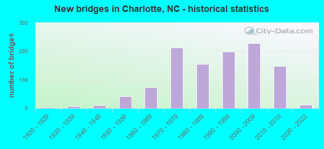
- New bridges - historical statistics
- 31920-1929
- 71930-1939
- 101940-1949
- 411950-1959
- 741960-1969
- 2131970-1979
- 1561980-1989
- 1981990-1999
- 2282000-2009
- 1482010-2019
- 122020-2022
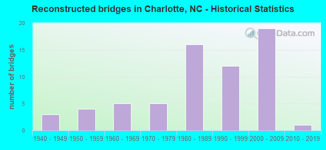
- Reconstructed bridges - Historical Statistics
- 31940-1949
- 41950-1959
- 51960-1969
- 51970-1979
- 161980-1989
- 121990-1999
- 192000-2009
- 12010-2019
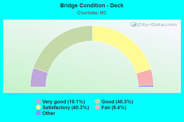
- Bridge Condition - Deck
- 10.1%Excellent
- 40.3%Very good
- 40.3%Good
- 8.4%Satisfactory
- 1.0%Fair
- 0.7%Poor
- Bridge Condition - Superstructure
- 29.5%Excellent
- 45.3%Very good
- 17.5%Good
- 6.0%Satisfactory
- 1.7%Fair
- 0.7%Poor
- 0.5%Serious
- Bridge Condition - Substructure
- 14.6%Excellent
- 48.7%Very good
- 24.5%Good
- 9.8%Satisfactory
- 1.9%Fair
- 0.5%Poor
- 0.2%Serious
- Bridge Condition - Channel
- 1.2%Excellent
- 1.8%Very good
- 73.8%Good
- 18.9%Satisfactory
- 4.0%Fair
- 0.3%Poor
- Bridge Condition - Culverts
- 1.1%Excellent
- 36.6%Very good
- 44.6%Good
- 16.7%Satisfactory
- 1.1%Fair
- 0.5%Serious
Find on map >> Show street view
Structure Number: 119131, Location: 125'N.TRAIN STATION DR. (Lat: 35.452117, Lng: -80.858000), Route carried "on" structure: City street , Year Built: 1980, Status: Open, Structure Length: 1.28m (4.20ft), Average Daily Traffic: 100 (year 2011), Truck Traffic: 7%, Average Future Daily Traffic: 200 (year 2040), Design Load: HS 20+Mod, Features Intersected: UT TO CALDWELL STA CREEK, Facility Carried by Structure: HAMPTON TRACE ROAD
Minimum Vertical Clearance: 30+ m (98+ ft), Kilometerpoint: 0.000, Lanes on structure: 2, Owner: City or Municipal Highway Agency, Approaching Roadway Width: 8.8m (28.9ft), Material/Design: Concrete, Design/Construction: Culvert, Number Of Spans In Main Unit: 1, Length of Maximum Span: 12.8m (42.0ft)
Condition: Channel: Fair, Culverts: Satisfactory, Operating Rating: 41.7 metric tons, Method Used To Determine Operating Rating: Field evaluation and documented engineering judgment, Inventory Rating: 32.6 metric tons, Method Used To Determine Inventory Rating: Field evaluation and documented engineering judgment, Structural Evaluation: Equal to present minimum criteria, Waterway Adequacy: Better than present minimum criteria, Approach Roadway Alignment: Equal to present desirable criteria, Designated Inspection Frequency: Every 24 months, Inspection Date: May 2020
Find on map >> Show street view
Structure Number: 1191314, Location: 0.1 MI. S. JCT. SR3998 (Lat: 35.120847, Lng: -80.881181), Route carried "on" structure: City street , Year Built: 2014, Status: Open, Structure Length: 4.93m (16.17ft), Average Daily Traffic: 5,000 (year 2015), Truck Traffic: 7%, Average Future Daily Traffic: 10,000 (year 2040), Design Load: HS 20+Mod, Features Intersected: NORFOLK SOUTHERN RR, Facility Carried by Structure: CRUMP ROAD
Minimum Vertical Clearance: 30+ m (98+ ft), Kilometerpoint: 0.000, Lanes on structure: 2, Owner: City or Municipal Highway Agency, Approaching Roadway Width: 11.8m (38.7ft), Material/Design: Steel continuous, Design/Construction: Stringer/Multi-beam, Number Of Spans In Main Unit: 2, Length of Maximum Span: 24.0m (78.7ft), Curb-To-Curb Width: 11.2m (36.7ft), Out-to-Out Width: 12.2m (40.0ft)
Condition: Deck: Good, Superstructure: Very good, Substructure: Very good, Operating Rating: 57.1 metric tons, Method Used To Determine Operating Rating: Load Factor (LF), Inventory Rating: 33.5 metric tons, Method Used To Determine Inventory Rating: Load Factor (LF), Structural Evaluation: Equal to present desirable criteria, Deck Geometry: Somewhat better than minimum adequacy, Underclear: High priority of corrective action, Approach Roadway Alignment: Equal to present minimum criteria, Designated Inspection Frequency: Every 24 months, Inspection Date: October 2021, Deck Structure Type: Concrete Cast-file-Place, Wearing Surface/Protective System: Wearing Surface: Monolithic Concrete, Membrane: Built-up, Deck Protection: Epoxy Coated Reinforcing
Find on map >> Show street view
Structure Number: 1191315, Location: .04MI.N.JCT.WILLIAMS ROAD (Lat: 35.244917, Lng: -80.728500), Route carried "on" structure: City street , Year Built: 1980, Status: Open, Structure Length: 1.18m (3.87ft), Average Daily Traffic: 500 (year 2012), Truck Traffic: 7%, Average Future Daily Traffic: 1,000 (year 2040), Design Load: HS 20+Mod, Features Intersected: LINDA LAKE, Facility Carried by Structure: LINDA LAKE DRIVE
Minimum Vertical Clearance: 30+ m (98+ ft), Kilometerpoint: 0.000, Lanes on structure: 2, Owner: City or Municipal Highway Agency, Approaching Roadway Width: 5.7m (18.7ft), Material/Design: Concrete continuous, Design/Construction: Culvert, Number Of Spans In Main Unit: 4, Length of Maximum Span: 2.7m (8.9ft), Curb-To-Curb Width: 7.4m (24.3ft), Out-to-Out Width: 8.5m (27.9ft)
Condition: Channel: Good, Culverts: Good, Operating Rating: 41.7 metric tons, Method Used To Determine Operating Rating: Field evaluation and documented engineering judgment, Inventory Rating: 32.6 metric tons, Method Used To Determine Inventory Rating: Field evaluation and documented engineering judgment, Structural Evaluation: Better than present minimum criteria, Deck Geometry: Meets minimum limits, Waterway Adequacy: Better than present minimum criteria, Approach Roadway Alignment: Equal to present desirable criteria, Designated Inspection Frequency: Every 24 months, Inspection Date: June 2020
Find on map >> Show street view
Structure Number: 1191317, Location: .5MI.E.JCT.US29(TRYON ST) (Lat: 35.251861, Lng: -80.791333), Route carried "on" structure: State highway 2975, Year Built: 2019, Status: Open, Structure Length: 25.78m (84.58ft), Average Daily Traffic: 34,000 (year 2014), Truck Traffic: 6%, Average Future Daily Traffic: 68,000 (year 2040), Design Load: HL 93, Features Intersected: BEARWOOD AVE,NCRR/NSRR
Minimum Vertical Clearance: 30+ m (98+ ft), Kilometerpoint: 0.000, Lanes on structure: 4, Lanes under structure: 4, Base Highway Network: Yes, Owner: State Highway Agency, Approaching Roadway Width: 16.4m (53.8ft), Skew: 1 degrees, Material/Design: Prestressed concrete continuous, Design/Construction: Stringer/Multi-beam, Number Of Spans In Main Unit: 7, Length of Maximum Span: 38.7m (127.0ft), Curb or Sidewalk Widths: Left: 1.9m (6.2ft), Right: 2.4m (7.9ft), Curb-To-Curb Width: 16.4m (53.8ft), Out-to-Out Width: 21.6m (70.9ft)
Condition: Deck: Very good, Superstructure: Good, Substructure: Very good, Operating Rating: 89.8 metric tons, Method Used To Determine Operating Rating: Load and Resistance Factor (LRFR), Inventory Rating: 54.4 metric tons, Method Used To Determine Inventory Rating: Load and Resistance Factor (LRFR), Structural Evaluation: Better than present minimum criteria, Deck Geometry: Meets minimum limits, Underclear: Somewhat better than minimum adequacy, Approach Roadway Alignment: Equal to present desirable criteria, Designated Inspection Frequency: Every 24 months, Inspection Date: August 2021, Deck Structure Type: Concrete Cast-file-Place, Wearing Surface/Protective System: Wearing Surface: Monolithic Concrete, Deck Protection: Epoxy Coated Reinforcing
Find on map >> Show street view
Structure Number: 1191318, Location: 0.1 MI. E. JCT. NC49 (Lat: 35.294000, Lng: -80.744056), Route carried "on" structure: State highway 5316, Year Built: 1980, Status: Open, Structure Length: 2.34m (7.68ft), Average Daily Traffic: 14,250 (year 2012), Truck Traffic: 7%, Average Future Daily Traffic: 28,500 (year 2040), Design Load: HS 20+Mod, Features Intersected: TOBY CREEK
Minimum Vertical Clearance: 30+ m (98+ ft), Kilometerpoint: 0.000, Lanes on structure: 2, Owner: State Highway Agency, Approaching Roadway Width: 13.1m (43.0ft), Skew: 24 degrees, Material/Design: Concrete continuous, Design/Construction: Culvert, Number Of Spans In Main Unit: 5, Length of Maximum Span: 3.0m (9.8ft)
Condition: Channel: Good, Culverts: Satisfactory, Operating Rating: 41.7 metric tons, Method Used To Determine Operating Rating: Field evaluation and documented engineering judgment, Inventory Rating: 32.6 metric tons, Method Used To Determine Inventory Rating: Field evaluation and documented engineering judgment, Structural Evaluation: Equal to present minimum criteria, Waterway Adequacy: Better than present minimum criteria, Approach Roadway Alignment: Equal to present desirable criteria, Designated Inspection Frequency: Every 24 months, Inspection Date: June 2020
Find on map >> Show street view
Structure Number: 1191319, Location: .3 MI.N.JCT.BALLANTYNE CM (Lat: 35.063611, Lng: -80.848611), Route carried "on" structure: Ramp Interstate 485, Year Built: 2014, Status: Open, Structure Length: 18.50m (60.70ft), Average Daily Traffic: 5,000 (year 2012), Truck Traffic: 16%, Average Future Daily Traffic: 10,000 (year 2040), Design Load: HL 93, Features Intersected: I485, US521
Minimum Vertical Clearance: 30+ m (98+ ft), Kilometerpoint: 0.000, Lanes on structure: 1, Lanes under structure: 10, Owner: State Highway Agency, Approaching Roadway Width: 12.1m (39.7ft), Skew: 9 degrees, Material/Design: Prestressed concrete, Design/Construction: Stringer/Multi-beam, Number Of Spans In Main Unit: 5, Length of Maximum Span: 39.3m (128.9ft), Curb-To-Curb Width: 11.5m (37.7ft), Out-to-Out Width: 12.5m (41.0ft)
Condition: Deck: Good, Superstructure: Good, Substructure: Good, Operating Rating: 67.1 metric tons, Method Used To Determine Operating Rating: Load and Resistance Factor (LRFR), Inventory Rating: 50.8 metric tons, Method Used To Determine Inventory Rating: Load and Resistance Factor (LRFR), Structural Evaluation: Better than present minimum criteria, Deck Geometry: Superior to present desirable criteria, Underclear: High priority of corrective action, Approach Roadway Alignment: Equal to present desirable criteria, Designated Inspection Frequency: Every 24 months, Inspection Date: October 2020, Deck Structure Type: Concrete Cast-file-Place, Wearing Surface/Protective System: Wearing Surface: Monolithic Concrete, Deck Protection: Epoxy Coated Reinforcing
Find on map >> Show street view
Structure Number: 119132, Location: 0.2 MI. NW I85 (Lat: 35.350619, Lng: -80.735611), Route carried "on" structure: Interstate 485, Year Built: 2015, Status: Open, Structure Length: 3.68m (12.07ft), Average Daily Traffic: 54,500 (year 2018), Truck Traffic: 16%, Average Future Daily Traffic: 109,000 (year 2040), Design Load: HL 93, Features Intersected: I485 OUTER RAMP TO I85S
Minimum Vertical Clearance: 30+ m (98+ ft), Kilometerpoint: 9.235, Lanes on structure: 3, Lanes under structure: 2, Base Highway Network: Yes (Inventory Route: 1, Subroute: 85), Owner: State Highway Agency, Approaching Roadway Width: 17.6m (57.7ft), Skew: 10 degrees, Material/Design: Prestressed concrete, Design/Construction: Stringer/Multi-beam, Number Of Spans In Main Unit: 1, Length of Maximum Span: 35.6m (116.8ft), Curb-To-Curb Width: 18.2m (59.7ft), Out-to-Out Width: 19.2m (63.0ft)
Condition: Deck: Good, Superstructure: Very good, Substructure: Very good, Operating Rating: 75.2 metric tons, Method Used To Determine Operating Rating: Load and Resistance Factor (LRFR), Inventory Rating: 55.3 metric tons, Method Used To Determine Inventory Rating: Load and Resistance Factor (LRFR), Structural Evaluation: Equal to present desirable criteria, Deck Geometry: Better than present minimum criteria, Underclear: Meets minimum limits, Approach Roadway Alignment: Equal to present desirable criteria, Designated Inspection Frequency: Every 24 months, Inspection Date: November 2020, Deck Structure Type: Concrete Cast-file-Place, Wearing Surface/Protective System: Wearing Surface: Monolithic Concrete, Deck Protection: Epoxy Coated Reinforcing
Find on map >> Show street view
Structure Number: 1191326, Location: 0.09 MI. S,JCT.I85 (Lat: 35.347111, Lng: -80.732694), Route carried "on" structure: Interstate 485, Year Built: 2015, Status: Open, Structure Length: 3.56m (11.68ft), Average Daily Traffic: 28,000 (year 2015), Truck Traffic: 16%, Average Future Daily Traffic: 56,000 (year 2040), Design Load: HL 93, Features Intersected: I-85 & I-485 INNER, RMP
Minimum Vertical Clearance: 30+ m (98+ ft), Kilometerpoint: 9.326, Lanes on structure: 3, Lanes under structure: 2, Owner: State Highway Agency, Approaching Roadway Width: 18.5m (60.7ft), Skew: 1 degrees, Material/Design: Prestressed concrete, Design/Construction: Stringer/Multi-beam, Number Of Spans In Main Unit: 1, Length of Maximum Span: 34.7m (113.8ft), Curb-To-Curb Width: 18.2m (59.7ft), Out-to-Out Width: 19.2m (63.0ft)
Condition: Deck: Good, Superstructure: Very good, Substructure: Good, Operating Rating: 73.4 metric tons, Method Used To Determine Operating Rating: Load and Resistance Factor (LRFR), Inventory Rating: 54.4 metric tons, Method Used To Determine Inventory Rating: Load and Resistance Factor (LRFR), Structural Evaluation: Better than present minimum criteria, Deck Geometry: Better than present minimum criteria, Underclear: Meets minimum limits, Approach Roadway Alignment: Equal to present desirable criteria, Designated Inspection Frequency: Every 24 months, Inspection Date: May 2020, Deck Structure Type: Concrete Cast-file-Place, Wearing Surface/Protective System: Wearing Surface: Monolithic Concrete
Find on map >> Show street view
Structure Number: 1191327, Location: 0.10 MI S. JCT. I-85 (Lat: 35.347214, Lng: -80.732361), Route carried "on" structure: Interstate 485, Year Built: 2015, Status: Open, Structure Length: 3.56m (11.68ft), Average Daily Traffic: 28,000 (year 2015), Truck Traffic: 16%, Average Future Daily Traffic: 56,000 (year 2040), Design Load: HL 93, Features Intersected: I-85 & I-485 RAMP F
Minimum Vertical Clearance: 30+ m (98+ ft), Kilometerpoint: 9.326, Lanes on structure: 3, Lanes under structure: 2, Owner: State Highway Agency, Approaching Roadway Width: 18.2m (59.7ft), Skew: 1 degrees, Material/Design: Prestressed concrete, Design/Construction: Stringer/Multi-beam, Number Of Spans In Main Unit: 1, Length of Maximum Span: 34.7m (113.8ft), Curb-To-Curb Width: 18.2m (59.7ft), Out-to-Out Width: 19.2m (63.0ft)
Condition: Deck: Good, Superstructure: Very good, Substructure: Good, Operating Rating: 73.4 metric tons, Method Used To Determine Operating Rating: Load and Resistance Factor (LRFR), Inventory Rating: 54.4 metric tons, Method Used To Determine Inventory Rating: Load and Resistance Factor (LRFR), Structural Evaluation: Better than present minimum criteria, Deck Geometry: Better than present minimum criteria, Underclear: Superior to present desirable criteria, Approach Roadway Alignment: Equal to present desirable criteria, Designated Inspection Frequency: Every 24 months, Inspection Date: May 2020, Deck Structure Type: Concrete Cast-file-Place, Wearing Surface/Protective System: Wearing Surface: Monolithic Concrete
Find on map >> Show street view
Structure Number: 1191328, Location: 1.2 MI. E. JCT. SR2467 (Lat: 35.346131, Lng: -80.732014), Route carried "on" structure: Interstate 485, Year Built: 2015, Status: Open, Structure Length: 3.62m (11.88ft), Average Daily Traffic: 30,500 (year 2018), Truck Traffic: 16%, Average Future Daily Traffic: 61,000 (year 2040), Design Load: HL 93, Features Intersected: I485 INNER RAMP TO I-85N
Minimum Vertical Clearance: 30+ m (98+ ft), Kilometerpoint: 0.000, Lanes on structure: 3, Lanes under structure: 2, Base Highway Network: Yes (Inventory Route: 1, Subroute: 85), Owner: State Highway Agency, Approaching Roadway Width: 18.5m (60.7ft), Skew: 11 degrees, Material/Design: Prestressed concrete, Design/Construction: Stringer/Multi-beam, Number Of Spans In Main Unit: 1, Length of Maximum Span: 35.3m (115.8ft), Curb-To-Curb Width: 18.3m (60.0ft), Out-to-Out Width: 19.3m (63.3ft)
Condition: Deck: Good, Superstructure: Good, Substructure: Good, Operating Rating: 68.0 metric tons, Method Used To Determine Operating Rating: Load and Resistance Factor (LRFR), Inventory Rating: 49.8 metric tons, Method Used To Determine Inventory Rating: Load and Resistance Factor (LRFR), Structural Evaluation: Better than present minimum criteria, Deck Geometry: Better than present minimum criteria, Underclear: Equal to present desirable criteria, Approach Roadway Alignment: Equal to present desirable criteria, Designated Inspection Frequency: Every 24 months, Inspection Date: November 2020, Deck Structure Type: Concrete Cast-file-Place, Wearing Surface/Protective System: Wearing Surface: Monolithic Concrete, Deck Protection: Epoxy Coated Reinforcing
Find on map >> Show street view
Structure Number: 1191329, Location: 0.10 MI. S. JCT. I-85 (Lat: 35.346389, Lng: -80.731667), Route carried "on" structure: Interstate 485, Year Built: 2015, Status: Open, Structure Length: 3.62m (11.88ft), Average Daily Traffic: 28,000 (year 2015), Truck Traffic: 16%, Average Future Daily Traffic: 56,000 (year 2040), Design Load: HL 93, Features Intersected: I-85 & I-485 RAMP E
Minimum Vertical Clearance: 30+ m (98+ ft), Kilometerpoint: 9.357, Lanes on structure: 3, Lanes under structure: 2, Owner: State Highway Agency, Approaching Roadway Width: 18.5m (60.7ft), Skew: 1 degrees, Material/Design: Prestressed concrete, Design/Construction: Stringer/Multi-beam, Number Of Spans In Main Unit: 1, Length of Maximum Span: 35.3m (115.8ft), Curb-To-Curb Width: 18.3m (60.0ft), Out-to-Out Width: 19.3m (63.3ft)
Condition: Deck: Good, Superstructure: Very good, Substructure: Good, Operating Rating: 68.0 metric tons, Method Used To Determine Operating Rating: Load and Resistance Factor (LRFR), Inventory Rating: 49.8 metric tons, Method Used To Determine Inventory Rating: Load and Resistance Factor (LRFR), Structural Evaluation: Better than present minimum criteria, Deck Geometry: Better than present minimum criteria, Underclear: Somewhat better than minimum adequacy, Approach Roadway Alignment: Equal to present desirable criteria, Designated Inspection Frequency: Every 24 months, Inspection Date: May 2020, Deck Structure Type: Concrete Cast-file-Place, Wearing Surface/Protective System: Wearing Surface: Monolithic Concrete
Find on map >> Show street view
Structure Number: 1191332, Location: 0.33 MI.N.JCT.FREEDOM DR. (Lat: 35.275178, Lng: -80.930044), Route carried "on" structure: City street , Year Built: 2010, Status: Open, Structure Length: 7.25m (23.79ft), Average Daily Traffic: 5,000 (year 2014), Truck Traffic: 7%, Average Future Daily Traffic: 10,000 (year 2040), Design Load: HS 20+Mod, Features Intersected: CSXT RR YARD, Facility Carried by Structure: FRED D.ALEXANDER B
Minimum Vertical Clearance: 30+ m (98+ ft), Kilometerpoint: 102.627, Lanes on structure: 4, Owner: City or Municipal Highway Agency, Approaching Roadway Width: 17.9m (58.7ft), Skew: 24 degrees, Material/Design: Prestressed concrete, Design/Construction: Stringer/Multi-beam, Number Of Spans In Main Unit: 3, Length of Maximum Span: 28.3m (92.8ft), Curb or Sidewalk Widths: Left: 1.6m (5.2ft), Right: 1.6m (5.2ft), Curb-To-Curb Width: 17.9m (58.7ft), Out-to-Out Width: 21.8m (71.5ft)
Condition: Deck: Very good, Superstructure: Very good, Substructure: Very good, Operating Rating: 55.3 metric tons, Method Used To Determine Operating Rating: Load Factor (LF), Inventory Rating: 32.6 metric tons, Method Used To Determine Inventory Rating: Load Factor (LF), Structural Evaluation: Equal to present desirable criteria, Deck Geometry: Somewhat better than minimum adequacy, Underclear: Somewhat better than minimum adequacy, Approach Roadway Alignment: Equal to present desirable criteria, Designated Inspection Frequency: Every 24 months, Inspection Date: December 2020, Deck Structure Type: Concrete Cast-file-Place, Wearing Surface/Protective System: Wearing Surface: Monolithic Concrete
Find on map >> Show street view
Structure Number: 1191334, Location: 0.5 MI.N.JCT.FREEDOM DR. (Lat: 35.275778, Lng: -80.927683), Route carried "on" structure: City street , Year Built: 2010, Status: Open, Structure Length: 4.57m (14.99ft), Average Daily Traffic: 5,000 (year 2014), Truck Traffic: 7%, Average Future Daily Traffic: 10,000 (year 2040), Design Load: HS 20+Mod, Features Intersected: CSXT SPUR TRACKS (RR), Facility Carried by Structure: FRED D.ALEXANDER B
Minimum Vertical Clearance: 30+ m (98+ ft), Kilometerpoint: 0.000, Lanes on structure: 4, Owner: City or Municipal Highway Agency, Approaching Roadway Width: 17.6m (57.7ft), Skew: 25 degrees, Material/Design: Steel, Design/Construction: Stringer/Multi-beam, Number Of Spans In Main Unit: 1, Length of Maximum Span: 43.5m (142.7ft), Curb or Sidewalk Widths: Left: 1.6m (5.2ft), Right: 1.6m (5.2ft), Curb-To-Curb Width: 18.5m (60.7ft), Out-to-Out Width: 22.6m (74.1ft)
Condition: Deck: Good, Superstructure: Very good, Substructure: Very good, Operating Rating: 49.8 metric tons, Method Used To Determine Operating Rating: Load Factor (LF), Inventory Rating: 29.0 metric tons, Method Used To Determine Inventory Rating: Load Factor (LF), Structural Evaluation: Better than present minimum criteria, Deck Geometry: Equal to present minimum criteria, Underclear: Better than present minimum criteria, Approach Roadway Alignment: Equal to present desirable criteria, Designated Inspection Frequency: Every 24 months, Inspection Date: December 2020, Deck Structure Type: Concrete Cast-file-Place, Wearing Surface/Protective System: Wearing Surface: Monolithic Concrete, Deck Protection: Epoxy Coated Reinforcing
Find on map >> Show street view
Structure Number: 1191335, Location: .25 MI. S. JCT. COLONY RD (Lat: 35.101744, Lng: -80.808569), Route carried "on" structure: City street , Year Built: 2012, Status: Open, Structure Length: 3.87m (12.70ft), Average Daily Traffic: 100 (year 2015), Truck Traffic: 7%, Average Future Daily Traffic: 200 (year 2040), Design Load: HS 20+Mod, Features Intersected: UT TO CARMEL LAKE, Facility Carried by Structure: REA ROAD
Minimum Vertical Clearance: 30+ m (98+ ft), Kilometerpoint: 0.000, Lanes on structure: 4, Owner: City or Municipal Highway Agency, Approaching Roadway Width: 13.1m (43.0ft), Skew: 22 degrees, Material/Design: Prestressed concrete, Design/Construction: Stringer/Multi-beam, Number Of Spans In Main Unit: 2, Length of Maximum Span: 25.2m (82.7ft), Curb or Sidewalk Widths: Left: 3.2m (10.5ft), Right: 3.2m (10.5ft), Curb-To-Curb Width: 12.8m (42.0ft), Out-to-Out Width: 20.4m (66.9ft)
Condition: Deck: Good, Superstructure: Very good, Substructure: Very good, Channel: Good, Operating Rating: 74.3 metric tons, Method Used To Determine Operating Rating: Load Factor (LF), Inventory Rating: 30.8 metric tons, Method Used To Determine Inventory Rating: Load Factor (LF), Structural Evaluation: Better than present minimum criteria, Deck Geometry: High priority of replacement, Waterway Adequacy: Better than present minimum criteria, Approach Roadway Alignment: Equal to present desirable criteria, Designated Inspection Frequency: Every 24 months, Inspection Date: June 2020, Deck Structure Type: Concrete Cast-file-Place, Wearing Surface/Protective System: Wearing Surface: Monolithic Concrete
Find on map >> Show street view
Structure Number: 1191336, Location: WOODBURY SUBDIVISION (Lat: 35.220800, Lng: -80.662267), Route carried "on" structure: City street , Year Built: 2012, Status: Open, Structure Length: 1.88m (6.17ft), Average Daily Traffic: 50 (year 2015), Truck Traffic: 7%, Average Future Daily Traffic: 100 (year 2025), Design Load: HS 20, Features Intersected: UT TO MCKEE CREEK, Facility Carried by Structure: DENBUR DRIVE
Minimum Vertical Clearance: 30+ m (98+ ft), Kilometerpoint: 0.000, Lanes on structure: 2, Owner: City or Municipal Highway Agency, Approaching Roadway Width: 8.5m (27.9ft), Skew: 3 degrees, Material/Design: Prestressed concrete, Design/Construction: Slab, Number Of Spans In Main Unit: 1, Length of Maximum Span: 17.6m (57.7ft), Curb or Sidewalk Widths: Left: 2.2m (7.2ft), Right: 2.1m (6.9ft), Curb-To-Curb Width: 8.6m (28.2ft), Out-to-Out Width: 13.7m (44.9ft)
Condition: Deck: Very good, Superstructure: Very good, Substructure: Very good, Channel: Very good, Operating Rating: 73.4 metric tons, Method Used To Determine Operating Rating: Load and Resistance Factor (LRFR), Inventory Rating: 57.1 metric tons, Method Used To Determine Inventory Rating: Load and Resistance Factor (LRFR), Structural Evaluation: Equal to present desirable criteria, Deck Geometry: Better than present minimum criteria, Approach Roadway Alignment: Equal to present desirable criteria, Designated Inspection Frequency: Every 24 months, Inspection Date: June 2020, Deck Structure Type: Concrete Precast Panels, Wearing Surface/Protective System: Wearing Surface: Bituminous
Find on map >> Show street view
Structure Number: 1191338, Location: I-277 ramp flyover from I (Lat: 35.244861, Lng: -80.846278), Route carried "on" structure: Ramp Interstate 277, Year Built: 2019, Status: Open, Structure Length: 20.48m (67.19ft), Average Daily Traffic: 66,500 (year 2018), Truck Traffic: 16%, Average Future Daily Traffic: 133,000 (year 2040), Design Load: HL 93, Features Intersected: I-77 NB
Minimum Vertical Clearance: 30+ m (98+ ft), Kilometerpoint: 1.524, Lanes on structure: 1, Lanes under structure: 4, Owner: State Highway Agency, Approaching Roadway Width: 7.9m (25.9ft), Material/Design: Prestressed concrete, Design/Construction: Stringer/Multi-beam, Number Of Spans In Main Unit: 6, Length of Maximum Span: 35.3m (115.8ft), Curb-To-Curb Width: 7.9m (25.9ft), Out-to-Out Width: 8.9m (29.2ft)
Condition: Deck: Good, Superstructure: Very good, Substructure: Good, Operating Rating: 78.9 metric tons, Method Used To Determine Operating Rating: Load and Resistance Factor (LRFR), Inventory Rating: 54.4 metric tons, Method Used To Determine Inventory Rating: Load and Resistance Factor (LRFR), Structural Evaluation: Better than present minimum criteria, Deck Geometry: Equal to present desirable criteria, Underclear: High priority of corrective action, Approach Roadway Alignment: Equal to present desirable criteria, Designated Inspection Frequency: Every 24 months, Inspection Date: March 2020, Deck Structure Type: Concrete Cast-file-Place, Wearing Surface/Protective System: Wearing Surface: Monolithic Concrete, Deck Protection: Epoxy Coated Reinforcing
Find on map >> Show street view
Structure Number: 1191339, Location: I-77 between Lasalle St. (Lat: 35.267583, Lng: -80.844911), Route carried "on" structure: Interstate 77, Year Built: 2019, Status: Open, Structure Length: 13.80m (45.28ft), Average Daily Traffic: 80,000 (year 2018), Truck Traffic: 16%, Average Future Daily Traffic: 160,000 (year 2040), Design Load: H 10, Features Intersected: I-77 Northbound
Minimum Vertical Clearance: 30+ m (98+ ft), Kilometerpoint: 3.962, Lanes on structure: 2, Lanes under structure: 3, Base Highway Network: Yes (Inventory Route: 1, Subroute: 77), Owner: State Highway Agency, Approaching Roadway Width: 11.2m (36.7ft), Skew: 1 degrees, Material/Design: Prestressed concrete, Design/Construction: Stringer/Multi-beam, Number Of Spans In Main Unit: 4, Length of Maximum Span: 35.6m (116.8ft), Curb-To-Curb Width: 11.5m (37.7ft), Out-to-Out Width: 12.5m (41.0ft)
Condition: Deck: Good, Superstructure: Very good, Substructure: Good, Operating Rating: 64.4 metric tons, Method Used To Determine Operating Rating: Load and Resistance Factor (LRFR), Inventory Rating: 48.9 metric tons, Method Used To Determine Inventory Rating: Load and Resistance Factor (LRFR), Structural Evaluation: Better than present minimum criteria, Deck Geometry: Somewhat better than minimum adequacy, Underclear: Meets minimum limits, Approach Roadway Alignment: Equal to present desirable criteria, Designated Inspection Frequency: Every 24 months, Inspection Date: March 2020, Deck Structure Type: Concrete Cast-file-Place, Wearing Surface/Protective System: Wearing Surface: Monolithic Concrete, Deck Protection: Epoxy Coated Reinforcing
Find on map >> Show street view
Structure Number: 119134, Location: I-77 between Lasalle St. (Lat: 35.273281, Lng: -80.843722), Route carried "on" structure: Interstate 77, Year Built: 2019, Status: Open, Structure Length: 7.46m (24.48ft), Average Daily Traffic: 80,000 (year 2018), Truck Traffic: 16%, Average Future Daily Traffic: 160,000 (year 2040), Design Load: HL 93, Features Intersected: I-85
Minimum Vertical Clearance: 30+ m (98+ ft), Kilometerpoint: 3.962, Lanes on structure: 2, Lanes under structure: 9, Base Highway Network: Yes (Inventory Route: 1, Subroute: 77), Owner: State Highway Agency, Approaching Roadway Width: 10.9m (35.8ft), Skew: 1 degrees, Material/Design: Prestressed concrete, Design/Construction: Stringer/Multi-beam, Number Of Spans In Main Unit: 2, Length of Maximum Span: 36.5m (119.8ft), Curb-To-Curb Width: 11.5m (37.7ft), Out-to-Out Width: 12.5m (41.0ft)
Condition: Deck: Good, Superstructure: Very good, Substructure: Very good, Operating Rating: 76.2 metric tons, Method Used To Determine Operating Rating: Load and Resistance Factor (LRFR), Inventory Rating: 51.7 metric tons, Method Used To Determine Inventory Rating: Load and Resistance Factor (LRFR), Structural Evaluation: Equal to present desirable criteria, Deck Geometry: Somewhat better than minimum adequacy, Underclear: High priority of corrective action, Approach Roadway Alignment: Equal to present desirable criteria, Designated Inspection Frequency: Every 24 months, Inspection Date: March 2020, Deck Structure Type: Concrete Cast-file-Place, Wearing Surface/Protective System: Wearing Surface: Monolithic Concrete, Deck Protection: Epoxy Coated Reinforcing
Find on map >> Show street view
Structure Number: 1191341, Location: I-77 between I-85 and I-7 (Lat: 35.276003, Lng: -80.843986), Route carried "on" structure: Interstate 77, Year Built: 2019, Status: Open, Structure Length: 2.77m (9.09ft), Average Daily Traffic: 80,000 (year 2018), Truck Traffic: 16%, Average Future Daily Traffic: 160,000 (year 2040), Design Load: HL 93, Features Intersected: I-85 Loop
Minimum Vertical Clearance: 30+ m (98+ ft), Kilometerpoint: 4.114, Lanes on structure: 2, Lanes under structure: 2, Base Highway Network: Yes (Inventory Route: 1, Subroute: 77), Owner: State Highway Agency, Approaching Roadway Width: 10.9m (35.8ft), Material/Design: Prestressed concrete, Design/Construction: Stringer/Multi-beam, Number Of Spans In Main Unit: 1, Length of Maximum Span: 27.1m (88.9ft), Curb-To-Curb Width: 11.5m (37.7ft), Out-to-Out Width: 12.5m (41.0ft)
Condition: Deck: Good, Superstructure: Very good, Substructure: Very good, Operating Rating: 69.8 metric tons, Method Used To Determine Operating Rating: Load and Resistance Factor (LRFR), Inventory Rating: 51.7 metric tons, Method Used To Determine Inventory Rating: Load and Resistance Factor (LRFR), Structural Evaluation: Equal to present desirable criteria, Deck Geometry: Somewhat better than minimum adequacy, Underclear: Better than present minimum criteria, Approach Roadway Alignment: Equal to present desirable criteria, Designated Inspection Frequency: Every 24 months, Inspection Date: March 2020, Deck Structure Type: Concrete Cast-file-Place, Wearing Surface/Protective System: Wearing Surface: Monolithic Concrete, Deck Protection: Epoxy Coated Reinforcing
Find on map >> Show street view
Structure Number: 1191342, Location: I77NB BW. I85 & CINDY LN. (Lat: 35.278056, Lng: -80.845278), Route carried "on" structure: Interstate 77, Year Built: 2019, Status: Open, Structure Length: 1.28m (4.20ft), Average Daily Traffic: 57,000 (year 2018), Truck Traffic: 16%, Average Future Daily Traffic: 114,000 (year 2040), Design Load: HL 93, Features Intersected: I-77 NB HOT LANES
Minimum Vertical Clearance: 30+ m (98+ ft), Kilometerpoint: 0.000, Lanes on structure: 3, Lanes under structure: 2, Base Highway Network: Yes (Inventory Route: 1, Subroute: 77), Owner: State Highway Agency, Approaching Roadway Width: 11.5m (37.7ft), Material/Design: Concrete, Design/Construction: Culvert, Number Of Spans In Main Unit: 1, Length of Maximum Span: 12.8m (42.0ft)
Condition: Culverts: Excellent, Operating Rating: 73.4 metric tons, Method Used To Determine Operating Rating: Load and Resistance Factor (LRFR), Inventory Rating: 57.1 metric tons, Method Used To Determine Inventory Rating: Load and Resistance Factor (LRFR), Structural Evaluation: Superior to present desirable criteria, Underclear: Equal to present minimum criteria, Approach Roadway Alignment: Equal to present desirable criteria, Designated Inspection Frequency: Every 24 months, Inspection Date: June 2020
Find on map >> Show street view
Structure Number: 1191344, Location: I-77 between Lasalle St. (Lat: 35.273056, Lng: -80.844444), Route carried "on" structure: Ramp Interstate 77, Year Built: 2019, Status: Open, Structure Length: 7.40m (24.28ft), Average Daily Traffic: 80,000 (year 2018), Truck Traffic: 16%, Average Future Daily Traffic: 160,000 (year 2040), Design Load: H 10, Features Intersected: I-85
Minimum Vertical Clearance: 30+ m (98+ ft), Kilometerpoint: 3.962, Lanes on structure: 1, Lanes under structure: 9, Base Highway Network: Yes (Inventory Route: 1, Subroute: 77), Owner: State Highway Agency, Approaching Roadway Width: 12.4m (40.7ft), Skew: 10 degrees, Material/Design: Prestressed concrete, Design/Construction: Stringer/Multi-beam, Number Of Spans In Main Unit: 2, Length of Maximum Span: 37.1m (121.7ft), Curb-To-Curb Width: 9.1m (29.9ft), Out-to-Out Width: 10.1m (33.1ft)
Condition: Deck: Good, Superstructure: Very good, Substructure: Very good, Operating Rating: 78.0 metric tons, Method Used To Determine Operating Rating: Load and Resistance Factor (LRFR), Inventory Rating: 49.8 metric tons, Method Used To Determine Inventory Rating: Load and Resistance Factor (LRFR), Structural Evaluation: Equal to present desirable criteria, Deck Geometry: Superior to present desirable criteria, Underclear: High priority of corrective action, Approach Roadway Alignment: Equal to present desirable criteria, Designated Inspection Frequency: Every 24 months, Inspection Date: March 2020, Deck Structure Type: Concrete Cast-file-Place, Wearing Surface/Protective System: Wearing Surface: Monolithic Concrete, Deck Protection: Epoxy Coated Reinforcing
Find on map >> Show street view
Structure Number: 1191345, Location: 0.2 MILE E. OF NC HWY 115 (Lat: 35.377594, Lng: -80.830325), Route carried "on" structure: City street , Year Built: 2009, Status: Open, Structure Length: 6.55m (21.49ft), Average Daily Traffic: 3,700 (year 2018), Truck Traffic: 7%, Average Future Daily Traffic: 7,400 (year 2040), Design Load: H 10, Features Intersected: SOUTHERN RAILROAD, Facility Carried by Structure: HAMBRIGHT ROAD
Minimum Vertical Clearance: 30+ m (98+ ft), Kilometerpoint: 0.000, Lanes on structure: 4, Owner: State Highway Agency, Approaching Roadway Width: 20.1m (65.9ft), Skew: 2 degrees, Material/Design: Prestressed concrete, Design/Construction: Box Beam or Girders - Multiple, Number Of Spans In Main Unit: 3, Length of Maximum Span: 22.8m (74.8ft), Curb or Sidewalk Widths: Left: 1.6m (5.2ft), Right: 1.6m (5.2ft), Curb-To-Curb Width: 22.5m (73.8ft), Out-to-Out Width: 27.0m (88.6ft)
Condition: Deck: Good, Superstructure: Very good, Substructure: Good, Operating Rating: 82.5 metric tons, Method Used To Determine Operating Rating: Load Factor (LF), Inventory Rating: 40.8 metric tons, Method Used To Determine Inventory Rating: Load Factor (LF), Structural Evaluation: Better than present minimum criteria, Deck Geometry: Superior to present desirable criteria, Underclear: Superior to present desirable criteria, Approach Roadway Alignment: Equal to present desirable criteria, Designated Inspection Frequency: Every 24 months, Inspection Date: March 2021, Deck Structure Type: Concrete Cast-file-Place, Wearing Surface/Protective System: Wearing Surface: Monolithic Concrete
Find on map >> Show street view
Structure Number: 1191357, Location: 0.5 MI.W.OF NC 29 (Lat: 35.298333, Lng: -80.763611), Route carried "on" structure: City street , Year Built: 2017, Status: Open, Structure Length: 7.80m (25.59ft), Average Daily Traffic: 2,500 (year 2015), Truck Traffic: 7%, Average Future Daily Traffic: 5,000 (year 2040), Design Load: HL 93, Features Intersected: I-85, Facility Carried by Structure: UNIV.POINTE BLVD
Minimum Vertical Clearance: 30+ m (98+ ft), Kilometerpoint: 0.000, Lanes on structure: 2, Lanes under structure: 10, Owner: State Highway Agency, Approaching Roadway Width: 14.3m (46.9ft), Skew: 2 degrees, Material/Design: Prestressed concrete continuous, Design/Construction: Stringer/Multi-beam, Number Of Spans In Main Unit: 2, Length of Maximum Span: 37.7m (123.7ft), Curb or Sidewalk Widths: Left: 2.2m (7.2ft), Right: 2.2m (7.2ft), Curb-To-Curb Width: 14.3m (46.9ft), Out-to-Out Width: 19.7m (64.6ft)
Condition: Deck: Good, Superstructure: Good, Substructure: Very good, Operating Rating: 82.5 metric tons, Method Used To Determine Operating Rating: Load and Resistance Factor (LRFR), Inventory Rating: 51.7 metric tons, Method Used To Determine Inventory Rating: Load and Resistance Factor (LRFR), Structural Evaluation: Better than present minimum criteria, Deck Geometry: Superior to present desirable criteria, Underclear: Equal to present minimum criteria, Approach Roadway Alignment: Equal to present minimum criteria, Designated Inspection Frequency: Every 24 months, Inspection Date: October 2021, Deck Structure Type: Concrete Cast-file-Place, Wearing Surface/Protective System: Wearing Surface: Monolithic Concrete, Deck Protection: Epoxy Coated Reinforcing
Find on map >> Show street view
Structure Number: 119136, Location: 0.1 MI E JCT CALDWELL ST. (Lat: 35.233333, Lng: -80.826667), Route carried "on" structure: City street , Year Built: 2013, Status: Open, Structure Length: 0.76m (2.49ft), Average Daily Traffic: 16,000 (year 2016), Truck Traffic: 6%, Average Future Daily Traffic: 32,000 (year 2040), Design Load: HS 20+Mod, Features Intersected: UT TO LITTLE SUGAR CREEK, Facility Carried by Structure: PARKWOOD AVENUE
Minimum Vertical Clearance: 30+ m (98+ ft), Kilometerpoint: 0.000, Lanes on structure: 4, Owner: City or Municipal Highway Agency, Approaching Roadway Width: 15.5m (50.9ft), Skew: 2 degrees, Material/Design: Concrete continuous, Design/Construction: Culvert, Number Of Spans In Main Unit: 2, Length of Maximum Span: 3.3m (10.8ft)
Condition: Channel: Good, Culverts: Good, Operating Rating: 41.7 metric tons, Method Used To Determine Operating Rating: Field evaluation and documented engineering judgment, Inventory Rating: 32.6 metric tons, Method Used To Determine Inventory Rating: Field evaluation and documented engineering judgment, Structural Evaluation: Better than present minimum criteria, Waterway Adequacy: Better than present minimum criteria, Approach Roadway Alignment: Equal to present desirable criteria, Designated Inspection Frequency: Every 24 months, Inspection Date: March 2020
Find on map >> Show street view
Structure Number: 1191361, Location: 0.1 MI S JCT 15TH STREET (Lat: 35.231667, Lng: -80.825278), Route carried "on" structure: City street , Year Built: 2013, Status: Open, Structure Length: 0.73m (2.40ft), Average Daily Traffic: 16,000 (year 2016), Truck Traffic: 7%, Average Future Daily Traffic: 32,000 (year 2040), Design Load: HS 20+Mod, Features Intersected: UT TO LITTLE SUGAR CREEK, Facility Carried by Structure: N DAVIDSON STREET
Minimum Vertical Clearance: 30+ m (98+ ft), Kilometerpoint: 0.000, Lanes on structure: 2, Owner: City or Municipal Highway Agency, Approaching Roadway Width: 7.9m (25.9ft), Material/Design: Concrete continuous, Design/Construction: Culvert, Number Of Spans In Main Unit: 2, Length of Maximum Span: 3.3m (10.8ft)
Condition: Channel: Good, Culverts: Good, Operating Rating: 41.7 metric tons, Method Used To Determine Operating Rating: Field evaluation and documented engineering judgment, Inventory Rating: 32.6 metric tons, Method Used To Determine Inventory Rating: Field evaluation and documented engineering judgment, Structural Evaluation: Better than present minimum criteria, Waterway Adequacy: Better than present minimum criteria, Approach Roadway Alignment: Equal to present desirable criteria, Designated Inspection Frequency: Every 24 months, Inspection Date: March 2020
Find on map >> Show street view
Structure Number: 1191362, Location: 200' E JCT N ALEXANDER ST (Lat: 35.230000, Lng: -80.816750), Route carried "on" structure: City street , Year Built: 2013, Status: Open, Structure Length: 1.03m (3.38ft), Average Daily Traffic: 1,000 (year 2016), Truck Traffic: 7%, Average Future Daily Traffic: 2,000 (year 2040), Design Load: HS 20+Mod, Features Intersected: UT TO LITTLE SUGAR CREEK, Facility Carried by Structure: BELMOMT AVENUE
Minimum Vertical Clearance: 30+ m (98+ ft), Kilometerpoint: 0.000, Lanes on structure: 2, Owner: City or Municipal Highway Agency, Approaching Roadway Width: 7.9m (25.9ft), Skew: 3 degrees, Material/Design: Concrete continuous, Design/Construction: Culvert, Length of Maximum Span: 4.2m (13.8ft), Curb or Sidewalk Widths: Left: 1.9m (6.2ft), Right: 1.9m (6.2ft), Curb-To-Curb Width: 7.7m (25.3ft), Out-to-Out Width: 12.9m (42.3ft)
Condition: Channel: Good, Culverts: Satisfactory, Operating Rating: 41.7 metric tons, Method Used To Determine Operating Rating: Field evaluation and documented engineering judgment, Inventory Rating: 32.6 metric tons, Method Used To Determine Inventory Rating: Field evaluation and documented engineering judgment, Structural Evaluation: Equal to present minimum criteria, Deck Geometry: Meets minimum limits, Waterway Adequacy: Better than present minimum criteria, Approach Roadway Alignment: Equal to present desirable criteria, Designated Inspection Frequency: Every 24 months, Inspection Date: March 2020, Wearing Surface/Protective System: Wearing Surface: Monolithic Concrete
Find on map >> Show street view
Structure Number: 1191364, Location: 250' N. JTC. INVERNESS RD (Lat: 35.161972, Lng: -80.837503), Route carried "on" structure: City street , Year Built: 1969, Status: Open, Structure Length: 0.67m (2.20ft), Average Daily Traffic: 10,000 (year 2016), Truck Traffic: 7%, Average Future Daily Traffic: 20,000 (year 2040), Design Load: HS 20+Mod, Features Intersected: UT TO BRIAR CREEK, Facility Carried by Structure: BARCLAY DOWNS DR.
Minimum Vertical Clearance: 30+ m (98+ ft), Kilometerpoint: 0.000, Lanes on structure: 2, Owner: City or Municipal Highway Agency, Approaching Roadway Width: 7.3m (24.0ft), Skew: 1 degrees, Material/Design: Concrete continuous, Design/Construction: Culvert, Number Of Spans In Main Unit: 2, Length of Maximum Span: 3.0m (9.8ft)
Condition: Channel: Satisfactory, Culverts: Satisfactory, Operating Rating: 87.9 metric tons, Method Used To Determine Operating Rating: Load and Resistance Factor (LRFR), Inventory Rating: 73.4 metric tons, Method Used To Determine Inventory Rating: Load and Resistance Factor (LRFR), Structural Evaluation: Equal to present minimum criteria, Waterway Adequacy: Better than present minimum criteria, Approach Roadway Alignment: Equal to present desirable criteria, Designated Inspection Frequency: Every 24 months, Inspection Date: July 2020
Find on map >> Show street view
Structure Number: 1191365, Location: 100' S.JTC. COLONYCROSSDR (Lat: 35.143167, Lng: -80.819056), Route carried "on" structure: City street , Year Built: 1990, Status: Open, Structure Length: 1.43m (4.69ft), Average Daily Traffic: 18,000 (year 2016), Truck Traffic: 7%, Average Future Daily Traffic: 36,000 (year 2040), Design Load: HS 20, Features Intersected: MCMULLEN CREEK, Facility Carried by Structure: COLONY ROAD
Minimum Vertical Clearance: 30+ m (98+ ft), Kilometerpoint: 0.000, Lanes on structure: 2, Owner: City or Municipal Highway Agency, Approaching Roadway Width: 14.6m (47.9ft), Skew: 1 degrees, Material/Design: Steel, Design/Construction: Culvert, Number Of Spans In Main Unit: 2, Length of Maximum Span: 6.7m (22.0ft)
Condition: Channel: Good, Culverts: Satisfactory, Operating Rating: 89.8 metric tons, Method Used To Determine Operating Rating: Load and Resistance Factor (LRFR), Inventory Rating: 89.8 metric tons, Method Used To Determine Inventory Rating: Load and Resistance Factor (LRFR), Structural Evaluation: Equal to present minimum criteria, Waterway Adequacy: Better than present minimum criteria, Approach Roadway Alignment: Equal to present desirable criteria, Designated Inspection Frequency: Every 24 months, Inspection Date: July 2020
Find on map >> Show street view
Structure Number: 1191366, Location: 100' N. JCT WOODDALE TERR (Lat: 35.214417, Lng: -80.869944), Route carried "on" structure: City street , Year Built: 2003, Status: Open, Structure Length: 0.70m (2.30ft), Average Daily Traffic: 1,000 (year 2016), Truck Traffic: 7%, Average Future Daily Traffic: 2,000 (year 2040), Design Load: HS 20, Features Intersected: IRWIN CREEK, Facility Carried by Structure: WILMORE DRIVE
Minimum Vertical Clearance: 30+ m (98+ ft), Kilometerpoint: 0.000, Lanes on structure: 2, Owner: City or Municipal Highway Agency, Approaching Roadway Width: 8.8m (28.9ft), Material/Design: Concrete continuous, Design/Construction: Culvert, Number Of Spans In Main Unit: 3, Length of Maximum Span: 1.8m (5.9ft)
Condition: Channel: Satisfactory, Culverts: Satisfactory, Operating Rating: 41.7 metric tons, Method Used To Determine Operating Rating: Field evaluation and documented engineering judgment, Inventory Rating: 32.6 metric tons, Method Used To Determine Inventory Rating: Field evaluation and documented engineering judgment, Structural Evaluation: Equal to present minimum criteria, Waterway Adequacy: Better than present minimum criteria, Approach Roadway Alignment: Equal to present desirable criteria, Designated Inspection Frequency: Every 24 months, Inspection Date: July 2020
Find on map >> Show street view
Structure Number: 1191367, Location: 125' S JCT MARLBROOK DRIV (Lat: 35.188778, Lng: -80.736667), Route carried "on" structure: City street , Year Built: 1977, Status: Open, Structure Length: 0.79m (2.59ft), Average Daily Traffic: 1,000 (year 2016), Average Future Daily Traffic: 2,000 (year 2040), Design Load: HS 20, Features Intersected: CAMPBELL CREEK TRIB, Facility Carried by Structure: IDLEBROOK DRIVE
Minimum Vertical Clearance: 30+ m (98+ ft), Kilometerpoint: 0.000, Lanes on structure: 2, Owner: City or Municipal Highway Agency, Approaching Roadway Width: 8.5m (27.9ft), Skew: 2 degrees, Material/Design: Concrete continuous, Design/Construction: Culvert, Number Of Spans In Main Unit: 3, Length of Maximum Span: 7.3m (24.0ft)
Condition: Channel: Good, Culverts: Good, Operating Rating: 41.7 metric tons, Method Used To Determine Operating Rating: Field evaluation and documented engineering judgment, Inventory Rating: 32.6 metric tons, Method Used To Determine Inventory Rating: Field evaluation and documented engineering judgment, Structural Evaluation: Better than present minimum criteria, Waterway Adequacy: Equal to present minimum criteria, Approach Roadway Alignment: Equal to present desirable criteria, Designated Inspection Frequency: Every 24 months, Inspection Date: July 2020
Find on map >> Show street view
Structure Number: 1191368, Location: AT JCT TARRINGTON AVE. (Lat: 35.203417, Lng: -80.772286), Route carried "on" structure: City street , Year Built: 2002, Status: Open, Structure Length: 0.94m (3.08ft), Average Daily Traffic: 1,000 (year 2016), Truck Traffic: 7%, Average Future Daily Traffic: 2,000 (year 2040), Design Load: HS 20, Features Intersected: EDWARDS BRANCH, Facility Carried by Structure: SHEFFIELD DRIVE
Minimum Vertical Clearance: 30+ m (98+ ft), Kilometerpoint: 0.000, Lanes on structure: 2, Owner: City or Municipal Highway Agency, Approaching Roadway Width: 9.4m (30.8ft), Skew: 2 degrees, Material/Design: Concrete, Design/Construction: Culvert, Number Of Spans In Main Unit: 1, Length of Maximum Span: 8.5m (27.9ft)
Condition: Channel: Good, Culverts: Good, Operating Rating: 41.7 metric tons, Method Used To Determine Operating Rating: Field evaluation and documented engineering judgment, Inventory Rating: 32.6 metric tons, Method Used To Determine Inventory Rating: Field evaluation and documented engineering judgment, Structural Evaluation: Better than present minimum criteria, Waterway Adequacy: Better than present minimum criteria, Approach Roadway Alignment: Equal to present desirable criteria, Designated Inspection Frequency: Every 24 months, Inspection Date: July 2020
Find on map >> Show street view
Structure Number: 1191369, Location: 200' W JCT TIMBER LAKE DR (Lat: 35.199556, Lng: -80.704611), Route carried "on" structure: City street , Year Built: 1994, Status: Open, Structure Length: 0.79m (2.59ft), Average Daily Traffic: 10,000 (year 2016), Truck Traffic: 7%, Average Future Daily Traffic: 20,000 (year 2040), Design Load: HS 20+Mod, Features Intersected: MCALPINE CREEK, Facility Carried by Structure: MARLWOOD CIRCLE
Minimum Vertical Clearance: 30+ m (98+ ft), Kilometerpoint: 0.000, Lanes on structure: 2, Owner: City or Municipal Highway Agency, Approaching Roadway Width: 7.9m (25.9ft), Skew: 1 degrees, Material/Design: Concrete continuous, Design/Construction: Culvert, Number Of Spans In Main Unit: 2, Length of Maximum Span: 3.6m (11.8ft)
Condition: Channel: Good, Culverts: Satisfactory, Operating Rating: 47.1 metric tons, Method Used To Determine Operating Rating: Load and Resistance Factor (LRFR), Inventory Rating: 35.3 metric tons, Method Used To Determine Inventory Rating: Load and Resistance Factor (LRFR), Structural Evaluation: Equal to present minimum criteria, Waterway Adequacy: Equal to present minimum criteria, Approach Roadway Alignment: Equal to present desirable criteria, Designated Inspection Frequency: Every 24 months, Inspection Date: July 2020
Find on map >> Show street view
Structure Number: 119137, Location: 100' N JCT GREEN TRAIL LN (Lat: 35.225861, Lng: -80.824778), Route carried "on" structure: City street , Year Built: 2009, Status: Open, Structure Length: 0.82m (2.69ft), Average Daily Traffic: 12,000 (year 2016), Truck Traffic: 7%, Average Future Daily Traffic: 24,000 (year 2040), Design Load: HS 20, Features Intersected: UT TO LITTLE SUGAR CREEK, Facility Carried by Structure: SEIGLE AVENUE
Minimum Vertical Clearance: 0.00m, Kilometerpoint: 0.000, Lanes on structure: 2, Owner: City or Municipal Highway Agency, Approaching Roadway Width: 10.9m (35.8ft), Material/Design: Concrete continuous, Design/Construction: Culvert, Number Of Spans In Main Unit: 2, Length of Maximum Span: 3.6m (11.8ft)
Condition: Channel: Good, Culverts: Good, Operating Rating: 41.7 metric tons, Method Used To Determine Operating Rating: Field evaluation and documented engineering judgment, Inventory Rating: 32.6 metric tons, Method Used To Determine Inventory Rating: Field evaluation and documented engineering judgment, Structural Evaluation: Better than present minimum criteria, Waterway Adequacy: Better than present minimum criteria, Approach Roadway Alignment: Equal to present desirable criteria, Designated Inspection Frequency: Every 24 months, Inspection Date: July 2020
Find on map >> Show street view
Structure Number: 1191371, Location: 100 N. JCT. WADE MORGAN R (Lat: 35.322861, Lng: -80.797472), Route carried "on" structure: City street , Year Built: 2002, Status: Open, Structure Length: 0.64m (2.10ft), Average Daily Traffic: 12,000 (year 2016), Truck Traffic: 7%, Average Future Daily Traffic: 24,000 (year 2040), Design Load: HS 20, Features Intersected: UT TO MALLARD CREEK, Facility Carried by Structure: HUBBARD ROAD
Minimum Vertical Clearance: 30+ m (98+ ft), Kilometerpoint: 0.000, Lanes on structure: 2, Owner: City or Municipal Highway Agency, Approaching Roadway Width: 8.8m (28.9ft), Skew: 1 degrees, Material/Design: Concrete continuous, Design/Construction: Culvert, Number Of Spans In Main Unit: 1, Length of Maximum Span: 6.0m (19.7ft)
Condition: Channel: Satisfactory, Culverts: Good, Operating Rating: 41.7 metric tons, Method Used To Determine Operating Rating: Field evaluation and documented engineering judgment, Inventory Rating: 32.6 metric tons, Method Used To Determine Inventory Rating: Field evaluation and documented engineering judgment, Structural Evaluation: Better than present minimum criteria, Waterway Adequacy: Somewhat better than minimum adequacy, Approach Roadway Alignment: Equal to present minimum criteria, Designated Inspection Frequency: Every 24 months, Inspection Date: April 2020
Find on map >> Show street view
Structure Number: 1191372, Location: 300' W JCT FERNHILL DRIVE (Lat: 35.152833, Lng: -80.890389), Route carried "on" structure: City street , Year Built: 2018, Status: Open, Structure Length: 0.85m (2.79ft), Average Daily Traffic: 6,500 (year 2016), Truck Traffic: 7%, Average Future Daily Traffic: 13,000 (year 2040), Design Load: HS 20+Mod, Features Intersected: KINGS BRANCH CREEK, Facility Carried by Structure: ARCHDALE DRIVE
Minimum Vertical Clearance: 30+ m (98+ ft), Kilometerpoint: 0.000, Lanes on structure: 2, Owner: City or Municipal Highway Agency, Approaching Roadway Width: 10.3m (33.8ft), Material/Design: Steel, Design/Construction: Culvert, Number Of Spans In Main Unit: 3, Length of Maximum Span: 2.4m (7.9ft)
Condition: Channel: Good, Culverts: Fair, Operating Rating: 89.8 metric tons, Method Used To Determine Operating Rating: Load and Resistance Factor (LRFR), Inventory Rating: 89.8 metric tons, Method Used To Determine Inventory Rating: Load and Resistance Factor (LRFR), Structural Evaluation: Somewhat better than minimum adequacy, Waterway Adequacy: Somewhat better than minimum adequacy, Approach Roadway Alignment: Equal to present desirable criteria, Designated Inspection Frequency: Every 24 months, Inspection Date: March 2020
Find on map >> Show street view
Structure Number: 1191374, Location: 100'N JCT SILVERSTREAM R (Lat: 35.103444, Lng: -80.791833), Route carried "on" structure: City street , Year Built: 2002, Status: Open, Structure Length: 0.91m (2.99ft), Average Daily Traffic: 1,500 (year 2016), Truck Traffic: 7%, Average Future Daily Traffic: 3,000 (year 2040), Design Load: HS 20, Features Intersected: UT TO MCALPINE CREEK, Facility Carried by Structure: SWANS RUN ROAD
Minimum Vertical Clearance: 30+ m (98+ ft), Kilometerpoint: 0.000, Lanes on structure: 2, Owner: City or Municipal Highway Agency, Approaching Roadway Width: 7.9m (25.9ft), Skew: 2 degrees, Material/Design: Concrete continuous, Design/Construction: Culvert, Number Of Spans In Main Unit: 1, Length of Maximum Span: 8.5m (27.9ft)
Condition: Channel: Good, Culverts: Good, Operating Rating: 41.7 metric tons, Method Used To Determine Operating Rating: Field evaluation and documented engineering judgment, Inventory Rating: 32.6 metric tons, Method Used To Determine Inventory Rating: Field evaluation and documented engineering judgment, Structural Evaluation: Better than present minimum criteria, Waterway Adequacy: Equal to present minimum criteria, Approach Roadway Alignment: Equal to present desirable criteria, Designated Inspection Frequency: Every 24 months, Inspection Date: July 2020
Find on map >> Show street view
Structure Number: 1191375, Location: 200' N JCT WEDGEWOOD DR (Lat: 35.169306, Lng: -80.859417), Route carried "on" structure: City street , Year Built: 2002, Status: Open, Structure Length: 1.03m (3.38ft), Average Daily Traffic: 4,000 (year 2016), Truck Traffic: 7%, Average Future Daily Traffic: 8,000 (year 2040), Design Load: HS 20, Features Intersected: UT TO LITTLE HOPE CREEK, Facility Carried by Structure: BRADBURY DRIVE
Minimum Vertical Clearance: 30+ m (98+ ft), Kilometerpoint: 0.000, Lanes on structure: 2, Owner: City or Municipal Highway Agency, Approaching Roadway Width: 8.5m (27.9ft), Skew: 1 degrees, Material/Design: Concrete, Design/Construction: Culvert, Number Of Spans In Main Unit: 1, Length of Maximum Span: 9.7m (31.8ft)
Condition: Channel: Good, Culverts: Good, Operating Rating: 41.7 metric tons, Method Used To Determine Operating Rating: Field evaluation and documented engineering judgment, Inventory Rating: 32.6 metric tons, Method Used To Determine Inventory Rating: Field evaluation and documented engineering judgment, Structural Evaluation: Better than present minimum criteria, Waterway Adequacy: Equal to present minimum criteria, Approach Roadway Alignment: Equal to present desirable criteria, Designated Inspection Frequency: Every 24 months, Inspection Date: July 2020
Find on map >> Show street view
Structure Number: 1191376, Location: 200FT S.OF JCT. RAMA RD (Lat: 35.178028, Lng: -80.767417), Route carried "on" structure: City street , Year Built: 2018, Status: Open, Structure Length: 0.73m (2.40ft), Average Daily Traffic: 1,400 (year 2016), Truck Traffic: 7%, Average Future Daily Traffic: 2,800 (year 2040), Design Load: HS 20, Features Intersected: MCMULLEN CREEK, Facility Carried by Structure: DONEGAL DRIVE
Minimum Vertical Clearance: 30+ m (98+ ft), Kilometerpoint: 0.000, Lanes on structure: 2, Owner: City or Municipal Highway Agency, Approaching Roadway Width: 8.5m (27.9ft), Material/Design: Steel, Design/Construction: Culvert, Number Of Spans In Main Unit: 3, Length of Maximum Span: 2.1m (6.9ft)
Condition: Channel: Good, Culverts: Good, Operating Rating: 89.8 metric tons, Method Used To Determine Operating Rating: Load and Resistance Factor (LRFR), Inventory Rating: 89.8 metric tons, Method Used To Determine Inventory Rating: Load and Resistance Factor (LRFR), Structural Evaluation: Better than present minimum criteria, Waterway Adequacy: Equal to present minimum criteria, Approach Roadway Alignment: Equal to present desirable criteria, Designated Inspection Frequency: Every 24 months, Inspection Date: July 2020
Find on map >> Show street view
Structure Number: 1191377, Location: 150 FT S. JCT.WEST WT HAR (Lat: 35.313556, Lng: -80.764000), Route carried "on" structure: City street , Year Built: 2018, Status: Open, Structure Length: 0.64m (2.10ft), Average Daily Traffic: 12,000 (year 2016), Truck Traffic: 7%, Average Future Daily Traffic: 24,000 (year 2040), Design Load: HS 20, Features Intersected: DOBY CREEK, Facility Carried by Structure: IBM DRIVE
Minimum Vertical Clearance: 30+ m (98+ ft), Kilometerpoint: 0.000, Lanes on structure: 6, Owner: City or Municipal Highway Agency, Approaching Roadway Width: 21.0m (68.9ft), Material/Design: Steel, Design/Construction: Culvert, Number Of Spans In Main Unit: 1, Length of Maximum Span: 6.0m (19.7ft)
Condition: Channel: Satisfactory, Culverts: Satisfactory, Operating Rating: 89.8 metric tons, Method Used To Determine Operating Rating: Load and Resistance Factor (LRFR), Inventory Rating: 89.8 metric tons, Method Used To Determine Inventory Rating: Load and Resistance Factor (LRFR), Structural Evaluation: Equal to present minimum criteria, Waterway Adequacy: Better than present minimum criteria, Approach Roadway Alignment: Equal to present desirable criteria, Designated Inspection Frequency: Every 24 months, Inspection Date: July 2020
Find on map >> Show street view
Structure Number: 1191378, Location: 200' N JCT PEARL PARK WAY (Lat: 35.211333, Lng: -80.837111), Route carried "on" structure: City street , Year Built: 1994, Status: Open, Structure Length: 1.28m (4.20ft), Average Daily Traffic: 29,000 (year 2016), Truck Traffic: 6%, Average Future Daily Traffic: 58,000 (year 2040), Design Load: HS 20, Features Intersected: UT TO LITTLE SUGAR CREEK, Facility Carried by Structure: KENILWORTH AVENUE
Minimum Vertical Clearance: 30+ m (98+ ft), Kilometerpoint: 0.000, Lanes on structure: 4, Owner: City or Municipal Highway Agency, Approaching Roadway Width: 20.7m (67.9ft), Skew: 5 degrees, Material/Design: Concrete continuous, Design/Construction: Culvert, Number Of Spans In Main Unit: 2, Length of Maximum Span: 2.1m (6.9ft)
Condition: Channel: Good, Culverts: Good, Operating Rating: 41.7 metric tons, Method Used To Determine Operating Rating: Field evaluation and documented engineering judgment, Inventory Rating: 32.6 metric tons, Method Used To Determine Inventory Rating: Field evaluation and documented engineering judgment, Structural Evaluation: Better than present minimum criteria, Waterway Adequacy: Better than present minimum criteria, Approach Roadway Alignment: Equal to present desirable criteria, Designated Inspection Frequency: Every 24 months, Inspection Date: July 2020
Find on map >> Show street view
Structure Number: 1191379, Location: 200' W JCT DONCASTER DR (Lat: 35.178306, Lng: -80.773111), Route carried "on" structure: City street , Year Built: 1969, Status: Open, Structure Length: 0.73m (2.40ft), Average Daily Traffic: 1,400 (year 2016), Truck Traffic: 7%, Average Future Daily Traffic: 2,800 (year 2040), Design Load: HS 20, Features Intersected: MCMULLEN CREEK, Facility Carried by Structure: ERINSHIRE ROAD
Minimum Vertical Clearance: 30+ m (98+ ft), Kilometerpoint: 0.000, Lanes on structure: 2, Owner: City or Municipal Highway Agency, Approaching Roadway Width: 8.5m (27.9ft), Skew: 2 degrees, Material/Design: Concrete continuous, Design/Construction: Culvert, Number Of Spans In Main Unit: 2, Length of Maximum Span: 3.0m (9.8ft)
Condition: Channel: Good, Culverts: Good, Operating Rating: 41.7 metric tons, Method Used To Determine Operating Rating: Field evaluation and documented engineering judgment, Inventory Rating: 32.6 metric tons, Method Used To Determine Inventory Rating: Field evaluation and documented engineering judgment, Structural Evaluation: Better than present minimum criteria, Waterway Adequacy: Better than present minimum criteria, Approach Roadway Alignment: Equal to present desirable criteria, Designated Inspection Frequency: Every 24 months, Inspection Date: July 2020
Find on map >> Show street view
Structure Number: 119138, Location: 100FT E.JCT. ERWIN RD. (Lat: 35.111611, Lng: -80.968944), Route carried "on" structure: City street , Year Built: 2018, Status: Open, Structure Length: 1.18m (3.87ft), Average Daily Traffic: 9,900 (year 2016), Truck Traffic: 7%, Average Future Daily Traffic: 19,800 (year 2040), Features Intersected: UT TO WALKER BRANCH, Facility Carried by Structure: LIONESS STREET
Minimum Vertical Clearance: 30+ m (98+ ft), Kilometerpoint: 0.000, Lanes on structure: 2, Owner: City or Municipal Highway Agency, Approaching Roadway Width: 8.5m (27.9ft), Material/Design: Steel, Design/Construction: Culvert, Number Of Spans In Main Unit: 3, Length of Maximum Span: 3.3m (10.8ft)
Condition: Channel: Good, Culverts: Good, Operating Rating: 89.8 metric tons, Method Used To Determine Operating Rating: Load and Resistance Factor (LRFR), Inventory Rating: 89.8 metric tons, Method Used To Determine Inventory Rating: Load and Resistance Factor (LRFR), Structural Evaluation: Better than present minimum criteria, Waterway Adequacy: Equal to present minimum criteria, Approach Roadway Alignment: Equal to present desirable criteria, Designated Inspection Frequency: Every 24 months, Inspection Date: July 2020
Find on map >> Show street view
Structure Number: 1191381, Location: 0.2 MI E.OF JCT. GAILES D (Lat: 35.165014, Lng: -80.987433), Route carried "on" structure: City street , Year Built: 2017, Status: Open, Structure Length: 0.91m (2.99ft), Average Daily Traffic: 17,000 (year 2016), Truck Traffic: 7%, Average Future Daily Traffic: 34,000 (year 2040), Design Load: HS 20, Features Intersected: BEAVERDAM CREEK, Facility Carried by Structure: GLENBURN LANE
Minimum Vertical Clearance: 30+ m (98+ ft), Kilometerpoint: 0.000, Lanes on structure: 2, Owner: City or Municipal Highway Agency, Approaching Roadway Width: 10.9m (35.8ft), Material/Design: Steel, Design/Construction: Culvert, Number Of Spans In Main Unit: 3, Length of Maximum Span: 2.4m (7.9ft)
Condition: Channel: Good, Culverts: Good, Operating Rating: 89.8 metric tons, Method Used To Determine Operating Rating: Load and Resistance Factor (LRFR), Inventory Rating: 89.8 metric tons, Method Used To Determine Inventory Rating: Load and Resistance Factor (LRFR), Structural Evaluation: Better than present minimum criteria, Waterway Adequacy: Equal to present minimum criteria, Approach Roadway Alignment: Equal to present desirable criteria, Designated Inspection Frequency: Every 24 months, Inspection Date: July 2020
Find on map >> Show street view
Structure Number: 1191382, Location: 0.1MI N.JCT.W/CASCADE POI (Lat: 35.200389, Lng: -80.917000), Route carried "on" structure: City street , Year Built: 2018, Status: Open, Structure Length: 1.06m (3.48ft), Average Daily Traffic: 7,700 (year 2016), Truck Traffic: 7%, Average Future Daily Traffic: 15,400 (year 2040), Design Load: HS 20, Features Intersected: GLEN LAKE, Facility Carried by Structure: GLEN LAKE DRIVE
Minimum Vertical Clearance: 30+ m (98+ ft), Kilometerpoint: 0.000, Lanes on structure: 2, Owner: City or Municipal Highway Agency, Approaching Roadway Width: 12.1m (39.7ft), Material/Design: Steel, Design/Construction: Culvert, Number Of Spans In Main Unit: 1, Length of Maximum Span: 10.6m (34.8ft), Curb or Sidewalk Widths: Left: 3.5m (11.5ft), Right: 3.4m (11.2ft), Curb-To-Curb Width: 12.1m (39.7ft), Out-to-Out Width: 20.0m (65.6ft)
Condition: Channel: Good, Culverts: Good, Operating Rating: 53.5 metric tons, Method Used To Determine Operating Rating: Load and Resistance Factor (LRFR), Inventory Rating: 41.7 metric tons, Method Used To Determine Inventory Rating: Load and Resistance Factor (LRFR), Structural Evaluation: Better than present minimum criteria, Deck Geometry: Somewhat better than minimum adequacy, Waterway Adequacy: Better than present minimum criteria, Approach Roadway Alignment: Equal to present desirable criteria, Designated Inspection Frequency: Every 24 months, Inspection Date: July 2020