Bridge Statistics for Council Bluffs, Iowa (IA)
Condition, Traffic, Stress, Structural Evaluation, Project Costs
- New bridges - historical statistics
- 171930-1939
- 51950-1959
- 641960-1969
- 181970-1979
- 211980-1989
- 111990-1999
- 122000-2009
- 452010-2019
- 62020-2022
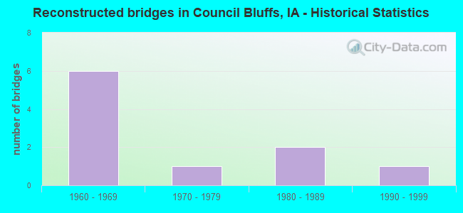
- Reconstructed bridges - Historical Statistics
- 61960-1969
- 11970-1979
- 21980-1989
- 11990-1999
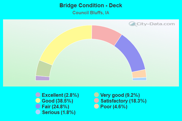
- Bridge Condition - Deck
- 2.8%Excellent
- 9.2%Very good
- 38.5%Good
- 18.3%Satisfactory
- 24.8%Fair
- 4.6%Poor
- 1.8%Serious
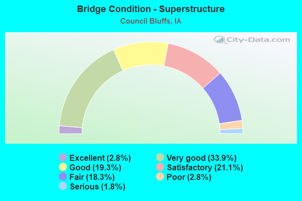
- Bridge Condition - Superstructure
- 2.8%Excellent
- 33.9%Very good
- 19.3%Good
- 21.1%Satisfactory
- 18.3%Fair
- 2.8%Poor
- 1.8%Serious
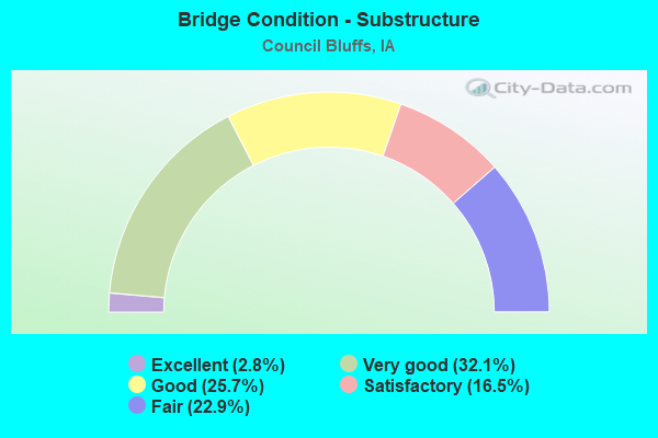
- Bridge Condition - Substructure
- 2.8%Excellent
- 32.1%Very good
- 25.7%Good
- 16.5%Satisfactory
- 22.9%Fair
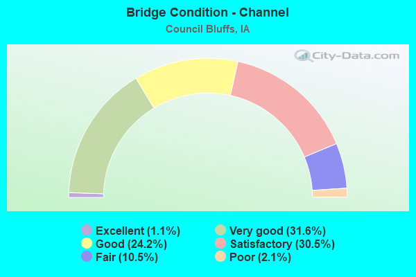
- Bridge Condition - Channel
- 1.1%Excellent
- 31.6%Very good
- 24.2%Good
- 30.5%Satisfactory
- 10.5%Fair
- 2.1%Poor
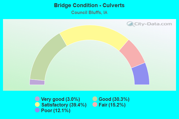
- Bridge Condition - Culverts
- 3.0%Very good
- 30.3%Good
- 39.4%Satisfactory
- 15.2%Fair
- 12.1%Poor
Find on map >> Show street view
Structure Number: 2658, Location: 000000000 (Lat: 41.268953, Lng: -95.807664), Route carried "on" structure: City street , Year Built: 1980, Status: Open, Structure Length: 7.01m (23.00ft), Average Daily Traffic: 740 (year 2008), Average Future Daily Traffic: 740 (year 2041), Design Load: HS 20, Features Intersected: MOSQUITO CREEK, Facility Carried by Structure: COLLEGE RD
Minimum Vertical Clearance: 30+ m (98+ ft), Kilometerpoint: 1.608, Lanes on structure: 2, Owner: City or Municipal Highway Agency, Approaching Roadway Width: 10.7m (35.1ft), Skew: 3 degrees, Material/Design: Prestressed concrete, Design/Construction: Stringer/Multi-beam, Number Of Spans In Main Unit: 3, Length of Maximum Span: 24.7m (81.0ft), Curb-To-Curb Width: 9.1m (29.9ft), Out-to-Out Width: 10.1m (33.1ft)
Condition: Deck: Satisfactory, Superstructure: Very good, Substructure: Good, Channel: Satisfactory, Operating Rating: 52.1 metric tons, Method Used To Determine Operating Rating: Load Factor (LF), Inventory Rating: 31.2 metric tons, Method Used To Determine Inventory Rating: Load Factor (LF), Structural Evaluation: Better than present minimum criteria, Deck Geometry: Equal to present minimum criteria, Waterway Adequacy: Equal to present minimum criteria, Approach Roadway Alignment: Equal to present desirable criteria, Designated Inspection Frequency: Every 24 months, Inspection Date: July 2021, Deck Structure Type: Concrete Cast-file-Place, Wearing Surface/Protective System: Wearing Surface: Monolithic Concrete
Find on map >> Show street view
Structure Number: 2661, Location: 000000000 (Lat: 41.279194, Lng: -95.835650), Route carried "on" structure: City street , Year Built: 1987, Status: Open, Structure Length: 1.07m (3.51ft), Average Daily Traffic: 1,690 (year 2012), Average Future Daily Traffic: 1,690 (year 2040), Design Load: HS 20, Features Intersected: INDIAN CREEK, Facility Carried by Structure: ELLIOTT ST
Minimum Vertical Clearance: 30+ m (98+ ft), Kilometerpoint: 1.138, Lanes on structure: 2, Owner: City or Municipal Highway Agency, Approaching Roadway Width: 7.9m (25.9ft), Material/Design: Concrete, Design/Construction: Slab, Number Of Spans In Main Unit: 1, Length of Maximum Span: 9.8m (32.2ft), Curb or Sidewalk Widths: Left: 1.8m (5.9ft), Right: 0.0m, Curb-To-Curb Width: 7.3m (24.0ft), Out-to-Out Width: 10.3m (33.8ft)
Condition: Deck: Satisfactory, Superstructure: Satisfactory, Substructure: Satisfactory, Channel: Satisfactory, Inventory Rating: 57.1 metric tons, Method Used To Determine Inventory Rating: Load Factor (LF), Structural Evaluation: Equal to present minimum criteria, Deck Geometry: Meets minimum limits, Waterway Adequacy: Better than present minimum criteria, Approach Roadway Alignment: Meets minimum limits, Designated Inspection Frequency: Every 48 months, Inspection Date: June 2020, Deck Structure Type: Concrete Cast-file-Place, Wearing Surface/Protective System: Wearing Surface: Monolithic Concrete, Deck Protection: Epoxy Coated Reinforcing
Find on map >> Show street view
Structure Number: 2671, Location: 000000000 (Lat: 41.280517, Lng: -95.835556), Route carried "on" structure: City street , Year Built: 1987, Status: Open, Structure Length: 1.07m (3.51ft), Average Daily Traffic: 853 (year 1998), Average Future Daily Traffic: 853 (year 2040), Design Load: HS 20, Features Intersected: INDIAN CREEK, Facility Carried by Structure: W ORCHARD AVE
Minimum Vertical Clearance: 30+ m (98+ ft), Kilometerpoint: 0.174, Lanes on structure: 2, Owner: City or Municipal Highway Agency, Approaching Roadway Width: 7.3m (24.0ft), Material/Design: Concrete, Design/Construction: Slab, Number Of Spans In Main Unit: 1, Length of Maximum Span: 9.8m (32.2ft), Curb or Sidewalk Widths: Left: 1.8m (5.9ft), Right: 0.0m, Curb-To-Curb Width: 7.3m (24.0ft), Out-to-Out Width: 10.3m (33.8ft)
Condition: Deck: Good, Superstructure: Good, Substructure: Good, Channel: Very good, Inventory Rating: 57.1 metric tons, Method Used To Determine Inventory Rating: Allowable Stress (AS), Structural Evaluation: Better than present minimum criteria, Deck Geometry: Meets minimum limits, Waterway Adequacy: Better than present minimum criteria, Approach Roadway Alignment: Meets minimum limits, Designated Inspection Frequency: Every 48 months, Inspection Date: June 2020, Deck Structure Type: Concrete Cast-file-Place, Wearing Surface/Protective System: Wearing Surface: Monolithic Concrete, Deck Protection: Epoxy Coated Reinforcing
Find on map >> Show street view
Structure Number: 2681, Location: 000000000 (Lat: 41.284392, Lng: -95.836119), Route carried "on" structure: City street , Year Built: 1988, Status: Open, Structure Length: 1.01m (3.31ft), Average Daily Traffic: 1,063 (year 1978), Average Future Daily Traffic: 1,063 (year 2041), Design Load: H 20, Features Intersected: INDIAN CREEK, Facility Carried by Structure: SYLVAN DR
Minimum Vertical Clearance: 30+ m (98+ ft), Kilometerpoint: 0.576, Lanes on structure: 2, Owner: City or Municipal Highway Agency, Approaching Roadway Width: 7.3m (24.0ft), Material/Design: Prestressed concrete, Design/Construction: Tee Beam, Number Of Spans In Main Unit: 1, Length of Maximum Span: 9.1m (29.9ft), Curb or Sidewalk Widths: Left: 0.0m, Right: 2.1m (6.9ft), Curb-To-Curb Width: 7.4m (24.3ft), Out-to-Out Width: 10.2m (33.5ft)
Condition: Deck: Good, Superstructure: Good, Substructure: Good, Channel: Satisfactory, Operating Rating: 44.5 metric tons, Method Used To Determine Operating Rating: Field evaluation and documented engineering judgment, Inventory Rating: 32.7 metric tons, Method Used To Determine Inventory Rating: Field evaluation and documented engineering judgment, Structural Evaluation: Better than present minimum criteria, Deck Geometry: Meets minimum limits, Waterway Adequacy: Better than present minimum criteria, Approach Roadway Alignment: Equal to present desirable criteria, Length Of Structure Improvement: 3.00m (9.84ft), Designated Inspection Frequency: Every 24 months, Inspection Date: July 2021, Bridge Improvement Cost: $185,000, Roadway Improvement Cost: $50,000, Deck Structure Type: Concrete Cast-file-Place, Wearing Surface/Protective System: Wearing Surface: Monolithic Concrete, Deck Protection: Epoxy Coated Reinforcing
Find on map >> Show street view
Structure Number: 2686, Location: 000000000 (Lat: 41.229036, Lng: -95.826869), Route carried "on" structure: City street , Year Built: 1996, Status: Open, Structure Length: 17.40m (57.09ft), Average Daily Traffic: 7,300 (year 2012), Average Future Daily Traffic: 7,300 (year 2041), Design Load: HS 20, Features Intersected: MOSQUITO CREEK & RR, Facility Carried by Structure: OLD IA 375
Minimum Vertical Clearance: 30+ m (98+ ft), Kilometerpoint: 1.539, Lanes on structure: 2, Owner: City or Municipal Highway Agency, Approaching Roadway Width: 12.2m (40.0ft), Material/Design: Steel continuous, Design/Construction: Girder and Floorbeam System, Number Of Spans In Main Unit: 4, Length of Maximum Span: 43.3m (142.1ft), Curb-To-Curb Width: 10.4m (34.1ft), Out-to-Out Width: 11.3m (37.1ft)
Condition: Deck: Satisfactory, Superstructure: Good, Substructure: Fair, Channel: Fair, Operating Rating: 57.8 metric tons, Method Used To Determine Operating Rating: Load Factor (LF), Inventory Rating: 34.6 metric tons, Method Used To Determine Inventory Rating: Load Factor (LF), Structural Evaluation: Somewhat better than minimum adequacy, Deck Geometry: Meets minimum limits, Underclear: Superior to present desirable criteria, Waterway Adequacy: Equal to present desirable criteria, Approach Roadway Alignment: Equal to present desirable criteria, Designated Inspection Frequency: Every 24 months, Inspection Date: July 2021, Deck Structure Type: Concrete Cast-file-Place, Wearing Surface/Protective System: Wearing Surface: Monolithic Concrete, Deck Protection: Epoxy Coated Reinforcing
Find on map >> Show street view
Structure Number: 2695, Location: Madison Ave over Mosquito (Lat: 41.242233, Lng: -95.818386), Route carried "on" structure: City street , Year Built: 1968, Year Reconstructed: 1999, Status: Open, Structure Length: 5.43m (17.81ft), Average Daily Traffic: 5,900 (year 2016), Average Future Daily Traffic: 5,900 (year 2040), Design Load: HS 20, Features Intersected: MOSQUITO CREEK, Facility Carried by Structure: MADISON AVE
Minimum Vertical Clearance: 30+ m (98+ ft), Kilometerpoint: 0.018, Lanes on structure: 4, Owner: City or Municipal Highway Agency, Approaching Roadway Width: 23.5m (77.1ft), Skew: 20 degrees, Material/Design: Steel continuous, Design/Construction: Stringer/Multi-beam, Number Of Spans In Main Unit: 3, Length of Maximum Span: 20.7m (67.9ft), Curb or Sidewalk Widths: Left: 0.0m, Right: 2.7m (8.9ft), Curb-To-Curb Width: 15.5m (50.9ft), Out-to-Out Width: 23.5m (77.1ft)
Condition: Deck: Good, Superstructure: Good, Substructure: Satisfactory, Channel: Satisfactory, Operating Rating: 60.0 metric tons, Method Used To Determine Operating Rating: Load Factor (LF), Inventory Rating: 36.0 metric tons, Method Used To Determine Inventory Rating: Load Factor (LF), Structural Evaluation: Equal to present minimum criteria, Deck Geometry: Meets minimum limits, Waterway Adequacy: Equal to present minimum criteria, Approach Roadway Alignment: Equal to present desirable criteria, Designated Inspection Frequency: Every 24 months, Inspection Date: June 2020, Deck Structure Type: Concrete Cast-file-Place, Wearing Surface/Protective System: Wearing Surface: Monolithic Concrete, Deck Protection: Epoxy Coated Reinforcing
Find on map >> Show street view
Structure Number: 27, Location: 000000000 (Lat: 41.264892, Lng: -95.842958), Route carried "on" structure: City street , Year Built: 1935, Status: Posted for load, Structure Length: 0.85m (2.79ft), Average Daily Traffic: 853 (year 1998), Average Future Daily Traffic: 853 (year 2041), Features Intersected: INDIAN CREEK, Facility Carried by Structure: BENTON ST
Minimum Vertical Clearance: 30+ m (98+ ft), Kilometerpoint: 0.097, Lanes on structure: 2, Owner: City or Municipal Highway Agency, Approaching Roadway Width: 9.4m (30.8ft), Material/Design: Concrete, Design/Construction: Stringer/Multi-beam, Number Of Spans In Main Unit: 1, Length of Maximum Span: 8.5m (27.9ft), Curb or Sidewalk Widths: Left: 1.8m (5.9ft), Right: 3.7m (12.1ft), Curb-To-Curb Width: 9.1m (29.9ft), Out-to-Out Width: 17.7m (58.1ft)
Condition: Deck: Serious, Superstructure: Serious, Substructure: Fair, Channel: Good, Operating Rating: 9.0 metric tons, Method Used To Determine Operating Rating: Field evaluation and documented engineering judgment, Inventory Rating: 9.0 metric tons, Method Used To Determine Inventory Rating: Field evaluation and documented engineering judgment, Structural Evaluation: High priority of replacement, Deck Geometry: Equal to present minimum criteria, Waterway Adequacy: Better than present minimum criteria, Approach Roadway Alignment: Equal to present minimum criteria, Bridge Posting: Required (Relationship of Operating Rating to Maximum Legal Load: > 39.9% below), Length Of Structure Improvement: 2.80m (9.19ft), Designated Inspection Frequency: Every 24 months, Inspection Date: July 2021, Bridge Improvement Cost: $100,000, Roadway Improvement Cost: $20,000, Deck Structure Type: Concrete Cast-file-Place, Wearing Surface/Protective System: Wearing Surface: Bituminous
Find on map >> Show street view
Structure Number: 3614, Location: AT JCT. OF I-29 (Lat: 41.149283, Lng: -95.822747), Route carried "on" structure: County highway , Year Built: 1968, Status: Open, Structure Length: 6.68m (21.92ft), Average Daily Traffic: 4,940 (year 2019), Truck Traffic: 12%, Average Future Daily Traffic: 4,940 (year 2041), Design Load: HS 20, Features Intersected: I-29, Facility Carried by Structure: BUNGE AVE
Minimum Vertical Clearance: 30+ m (98+ ft), Kilometerpoint: 5.156, Lanes on structure: 2, Lanes under structure: 4, Base Highway Network: Yes, Owner: State Highway Agency, Approaching Roadway Width: 13.4m (44.0ft), Material/Design: Prestressed concrete, Design/Construction: Stringer/Multi-beam, Number Of Spans In Main Unit: 4, Length of Maximum Span: 21.0m (68.9ft), Curb-To-Curb Width: 9.8m (32.2ft), Out-to-Out Width: 10.8m (35.4ft)
Condition: Deck: Satisfactory, Superstructure: Good, Substructure: Good, Operating Rating: 72.7 metric tons, Method Used To Determine Operating Rating: Load Factor (LF), Inventory Rating: 43.6 metric tons, Method Used To Determine Inventory Rating: Load Factor (LF), Structural Evaluation: Better than present minimum criteria, Deck Geometry: Meets minimum limits, Underclear: Meets minimum limits, Approach Roadway Alignment: Equal to present minimum criteria, Designated Inspection Frequency: Every 24 months, Inspection Date: April 2021, Deck Structure Type: Concrete Cast-file-Place, Wearing Surface/Protective System: Wearing Surface: Low Slump Concrete
Find on map >> Show street view
Structure Number: 3636, Location: 1.8 mi. S of Jct. SR H-10 (Lat: 41.123083, Lng: -95.822811), Route carried "on" structure: County highway , Year Built: 1970, Status: Open, Structure Length: 6.95m (22.80ft), Average Daily Traffic: 80 (year 2016), Average Future Daily Traffic: 80 (year 2041), Design Load: H 20, Features Intersected: I-29, Facility Carried by Structure: ALLIS ROAD
Minimum Vertical Clearance: 30+ m (98+ ft), Kilometerpoint: 2.390, Lanes on structure: 2, Lanes under structure: 4, Owner: State Highway Agency, Approaching Roadway Width: 8.5m (27.9ft), Skew: 1 degrees, Material/Design: Prestressed concrete, Design/Construction: Stringer/Multi-beam, Number Of Spans In Main Unit: 4, Length of Maximum Span: 21.0m (68.9ft), Curb or Sidewalk Widths: Left: 0.2m (0.7ft), Right: 0.2m (0.7ft), Curb-To-Curb Width: 8.6m (28.2ft), Out-to-Out Width: 9.6m (31.5ft)
Condition: Deck: Good, Superstructure: Very good, Substructure: Very good, Operating Rating: 67.4 metric tons, Method Used To Determine Operating Rating: Load Factor (LF), Inventory Rating: 25.0 metric tons, Method Used To Determine Inventory Rating: Load Factor (LF), Structural Evaluation: Equal to present minimum criteria, Deck Geometry: Better than present minimum criteria, Underclear: Meets minimum limits, Approach Roadway Alignment: Equal to present minimum criteria, Designated Inspection Frequency: Every 24 months, Inspection Date: April 2021, Deck Structure Type: Concrete Cast-file-Place, Wearing Surface/Protective System: Wearing Surface: Monolithic Concrete
Find on map >> Show street view
Structure Number: 36371, Location: 0.9 mi. S of Jct. IA 370 (Lat: 41.136369, Lng: -95.820617), Route carried "on" structure: Interstate 29, Year Built: 2009, Status: Open, Structure Length: 3.75m (12.30ft), Average Daily Traffic: 9,400 (year 2020), Truck Traffic: 23%, Average Future Daily Traffic: 9,400 (year 2041), Design Load: HS 20, Features Intersected: ST MARYS CREEK
Minimum Vertical Clearance: 30+ m (98+ ft), Kilometerpoint: 67.512, Lanes on structure: 2, Base Highway Network: Yes, Owner: State Highway Agency, Approaching Roadway Width: 12.2m (40.0ft), Skew: 3 degrees, Material/Design: Concrete continuous, Design/Construction: Slab, Number Of Spans In Main Unit: 3, Length of Maximum Span: 14.3m (46.9ft), Curb-To-Curb Width: 12.2m (40.0ft), Out-to-Out Width: 13.2m (43.3ft)
Condition: Deck: Good, Superstructure: Good, Substructure: Very good, Channel: Very good, Operating Rating: 74.8 metric tons, Method Used To Determine Operating Rating: Load Factor (LF), Inventory Rating: 44.9 metric tons, Method Used To Determine Inventory Rating: Load Factor (LF), Structural Evaluation: Better than present minimum criteria, Deck Geometry: Better than present minimum criteria, Waterway Adequacy: Equal to present desirable criteria, Approach Roadway Alignment: Equal to present desirable criteria, Designated Inspection Frequency: Every 24 months, Inspection Date: December 2021, Deck Structure Type: Concrete Cast-file-Place, Wearing Surface/Protective System: Wearing Surface: Monolithic Concrete, Deck Protection: Epoxy Coated Reinforcing
Find on map >> Show street view
Structure Number: 36381, Location: 0.9 mi. S of Jct. IA 370 (Lat: 41.136703, Lng: -95.820914), Route carried "on" structure: Interstate 29, Year Built: 2009, Status: Open, Structure Length: 3.75m (12.30ft), Average Daily Traffic: 9,400 (year 2020), Truck Traffic: 23%, Average Future Daily Traffic: 9,400 (year 2041), Design Load: HS 20, Features Intersected: ST MARYS CREEK
Minimum Vertical Clearance: 30+ m (98+ ft), Kilometerpoint: 176.933, Lanes on structure: 2, Owner: State Highway Agency, Approaching Roadway Width: 12.2m (40.0ft), Skew: 3 degrees, Material/Design: Concrete continuous, Design/Construction: Slab, Number Of Spans In Main Unit: 3, Length of Maximum Span: 14.3m (46.9ft), Curb-To-Curb Width: 12.2m (40.0ft), Out-to-Out Width: 13.2m (43.3ft)
Condition: Deck: Good, Superstructure: Good, Substructure: Very good, Channel: Very good, Operating Rating: 74.8 metric tons, Method Used To Determine Operating Rating: Load Factor (LF), Inventory Rating: 44.9 metric tons, Method Used To Determine Inventory Rating: Load Factor (LF), Structural Evaluation: Better than present minimum criteria, Deck Geometry: Better than present minimum criteria, Waterway Adequacy: Equal to present desirable criteria, Approach Roadway Alignment: Equal to present desirable criteria, Designated Inspection Frequency: Every 24 months, Inspection Date: December 2021, Deck Structure Type: Concrete Cast-file-Place, Wearing Surface/Protective System: Wearing Surface: Monolithic Concrete, Deck Protection: Epoxy Coated Reinforcing
Find on map >> Show street view
Structure Number: 43131, Location: 3.2 MI. E. OF NEBR. LINE (Lat: 41.261844, Lng: -95.864075), Route carried "on" structure: City street , Year Built: 2011, Status: Open, Structure Length: 47.03m (154.30ft), Average Daily Traffic: 12,800 (year 2016), Average Future Daily Traffic: 12,800 (year 2041), Design Load: HL 93, Features Intersected: UP&CNIC RR & CITY STREET, Facility Carried by Structure: W BROADWAY
Minimum Vertical Clearance: 30+ m (98+ ft), Kilometerpoint: 3.404, Lanes on structure: 4, Lanes under structure: 8, Base Highway Network: Yes, Owner: City or Municipal Highway Agency, Approaching Roadway Width: 17.7m (58.1ft), Skew: 30 degrees, Material/Design: Prestressed concrete, Design/Construction: Stringer/Multi-beam, Number Of Spans In Main Unit: 12, Length of Maximum Span: 46.3m (151.9ft), Curb or Sidewalk Widths: Left: 3.0m (9.8ft), Right: 0.0m, Curb-To-Curb Width: 20.8m (68.2ft), Out-to-Out Width: 22.6m (74.1ft)
Condition: Deck: Satisfactory, Superstructure: Very good, Substructure: Very good, Operating Rating: 42.1 metric tons, Method Used To Determine Operating Rating: Assigned ratings based on Load and Resistance Factor Design (LRFD) reported by rating factor (RF) using HL93 loadings, Inventory Rating: 32.4 metric tons, Method Used To Determine Inventory Rating: Assigned ratings based on Load and Resistance Factor Design (LRFD) reported by rating factor (RF) using HL93 loadings, Structural Evaluation: Equal to present desirable criteria, Deck Geometry: Superior to present desirable criteria, Underclear: Better than present minimum criteria, Approach Roadway Alignment: Equal to present desirable criteria, Designated Inspection Frequency: Every 24 months, Inspection Date: July 2021, Deck Structure Type: Concrete Cast-file-Place, Wearing Surface/Protective System: Wearing Surface: Monolithic Concrete, Deck Protection: Epoxy Coated Reinforcing
Find on map >> Show street view
Structure Number: 4314, Location: 1.0 MI. W. OF JCT. I-80 (Lat: 41.279392, Lng: -95.806386), Route carried "on" structure: State highway 906, Year Built: 1968, Status: Open, Structure Length: 5.09m (16.70ft), Average Daily Traffic: 3,550 (year 2020), Truck Traffic: 5%, Average Future Daily Traffic: 3,550 (year 2041), Design Load: HS 20, Features Intersected: BNSF RR
Minimum Vertical Clearance: 30+ m (98+ ft), Kilometerpoint: 4.479, Lanes on structure: 2, Base Highway Network: Yes, Owner: State Highway Agency, Approaching Roadway Width: 12.2m (40.0ft), Skew: 1 degrees, Material/Design: Prestressed concrete, Design/Construction: Stringer/Multi-beam, Number Of Spans In Main Unit: 3, Length of Maximum Span: 17.4m (57.1ft), Curb-To-Curb Width: 9.8m (32.2ft), Out-to-Out Width: 10.8m (35.4ft)
Condition: Deck: Good, Superstructure: Good, Substructure: Good, Operating Rating: 65.7 metric tons, Method Used To Determine Operating Rating: Load Factor (LF), Inventory Rating: 26.3 metric tons, Method Used To Determine Inventory Rating: Load Factor (LF), Structural Evaluation: Equal to present minimum criteria, Deck Geometry: Meets minimum limits, Underclear: Equal to present minimum criteria, Approach Roadway Alignment: Equal to present desirable criteria, Designated Inspection Frequency: Every 24 months, Inspection Date: May 2021, Deck Structure Type: Concrete Cast-file-Place, Wearing Surface/Protective System: Wearing Surface: Monolithic Concrete
Find on map >> Show street view
Structure Number: 4315, Location: 1.0 MI. W. OF JCT. I-80 (Lat: 41.279544, Lng: -95.805783), Route carried "on" structure: State highway 906, Year Built: 1968, Status: Open, Structure Length: 5.09m (16.70ft), Average Daily Traffic: 3,550 (year 2020), Truck Traffic: 5%, Average Future Daily Traffic: 3,550 (year 2041), Design Load: HS 20, Features Intersected: BNSF RR
Minimum Vertical Clearance: 30+ m (98+ ft), Kilometerpoint: 1.928, Lanes on structure: 2, Owner: State Highway Agency, Approaching Roadway Width: 12.2m (40.0ft), Skew: 1 degrees, Material/Design: Prestressed concrete, Design/Construction: Stringer/Multi-beam, Number Of Spans In Main Unit: 3, Length of Maximum Span: 17.4m (57.1ft), Curb-To-Curb Width: 9.8m (32.2ft), Out-to-Out Width: 10.8m (35.4ft)
Condition: Deck: Good, Superstructure: Good, Substructure: Good, Operating Rating: 66.2 metric tons, Method Used To Determine Operating Rating: Load Factor (LF), Inventory Rating: 23.9 metric tons, Method Used To Determine Inventory Rating: Load Factor (LF), Structural Evaluation: Equal to present minimum criteria, Deck Geometry: Meets minimum limits, Underclear: Somewhat better than minimum adequacy, Approach Roadway Alignment: Equal to present minimum criteria, Designated Inspection Frequency: Every 24 months, Inspection Date: May 2021, Deck Structure Type: Concrete Cast-file-Place, Wearing Surface/Protective System: Wearing Surface: Low Slump Concrete
Find on map >> Show street view
Structure Number: 4317, Location: 1.0 MI. W OF Jct. I-80 (Lat: 41.279611, Lng: -95.803386), Route carried "on" structure: State highway 906, Year Built: 1968, Status: Open, Structure Length: 11.16m (36.61ft), Average Daily Traffic: 3,550 (year 2020), Truck Traffic: 5%, Average Future Daily Traffic: 3,550 (year 2041), Design Load: HS 20, Features Intersected: MOSQUITO CREEK
Minimum Vertical Clearance: 30+ m (98+ ft), Kilometerpoint: 1.727, Lanes on structure: 2, Owner: State Highway Agency, Approaching Roadway Width: 12.2m (40.0ft), Skew: 2 degrees, Material/Design: Steel continuous, Design/Construction: Girder and Floorbeam System, Number Of Spans In Main Unit: 3, Length of Maximum Span: 42.7m (140.1ft), Curb-To-Curb Width: 9.8m (32.2ft), Out-to-Out Width: 10.8m (35.4ft)
Condition: Deck: Satisfactory, Superstructure: Fair, Substructure: Good, Channel: Satisfactory, Operating Rating: 47.8 metric tons, Method Used To Determine Operating Rating: Load Factor (LF), Inventory Rating: 28.7 metric tons, Method Used To Determine Inventory Rating: Load Factor (LF), Structural Evaluation: Somewhat better than minimum adequacy, Deck Geometry: Meets minimum limits, Waterway Adequacy: Equal to present minimum criteria, Approach Roadway Alignment: Equal to present desirable criteria, Designated Inspection Frequency: Every 24 months, Critical Feature Inspection Frequency: Every 24 months, Other Special Inspection Frequency: Every 24 months, Inspection Date: September 2021, Critical Feature Inspection Date: September 2021, Other Special Inspection Date: September 2020, Deck Structure Type: Concrete Cast-file-Place, Wearing Surface/Protective System: Wearing Surface: Low Slump Concrete
Find on map >> Show street view
Structure Number: 4321, Location: 0.9 MI. E OF JCT. I-80 (Lat: 41.280747, Lng: -95.767086), Route carried "on" structure: US 6, Year Built: 1968, Status: Open, Structure Length: 0.88m (2.89ft), Average Daily Traffic: 5,800 (year 2020), Truck Traffic: 6%, Average Future Daily Traffic: 5,800 (year 2041), Design Load: HS 20, Features Intersected: LITTLE MOSQUITO CREEK
Minimum Vertical Clearance: 30+ m (98+ ft), Kilometerpoint: 18.242, Lanes on structure: 2, Base Highway Network: Yes, Owner: State Highway Agency, Approaching Roadway Width: 13.4m (44.0ft), Skew: 3 degrees, Material/Design: Concrete continuous, Design/Construction: Culvert, Number Of Spans In Main Unit: 2, Length of Maximum Span: 4.3m (14.1ft)
Condition: Channel: Satisfactory, Culverts: Satisfactory, Structural Evaluation: Equal to present minimum criteria, Waterway Adequacy: Equal to present minimum criteria, Approach Roadway Alignment: Better than present minimum criteria, Designated Inspection Frequency: Every 24 months, Inspection Date: May 2021
Find on map >> Show street view
Structure Number: 43511, Location: 074431617 (Lat: 41.209739, Lng: -95.788917), Route carried "on" structure: County highway , Year Built: 1991, Status: Open, Structure Length: 5.52m (18.11ft), Average Daily Traffic: 4,510 (year 2016), Truck Traffic: 10%, Average Future Daily Traffic: 4,510 (year 2040), Design Load: HS 20, Features Intersected: PONY CREEK, Facility Carried by Structure: CO RD L35
Minimum Vertical Clearance: 30+ m (98+ ft), Kilometerpoint: 6.527, Lanes on structure: 2, Base Highway Network: Yes, Owner: County Highway Agency, Approaching Roadway Width: 15.9m (52.2ft), Skew: 1 degrees, Material/Design: Concrete continuous, Design/Construction: Slab, Number Of Spans In Main Unit: 5, Length of Maximum Span: 11.9m (39.0ft), Curb-To-Curb Width: 12.2m (40.0ft), Out-to-Out Width: 13.2m (43.3ft)
Condition: Deck: Satisfactory, Superstructure: Good, Substructure: Satisfactory, Channel: Fair, Operating Rating: 44.4 metric tons, Method Used To Determine Operating Rating: Allowable Stress (AS), Inventory Rating: 32.7 metric tons, Method Used To Determine Inventory Rating: Allowable Stress (AS), Structural Evaluation: Equal to present minimum criteria, Deck Geometry: Equal to present minimum criteria, Waterway Adequacy: Equal to present desirable criteria, Approach Roadway Alignment: Equal to present desirable criteria, Designated Inspection Frequency: Every 24 months, Inspection Date: May 2020, Deck Structure Type: Concrete Cast-file-Place, Wearing Surface/Protective System: Wearing Surface: Monolithic Concrete, Deck Protection: Epoxy Coated Reinforcing
Find on map >> Show street view
Structure Number: 43531, Location: 0.4 MI. E. OF JCT I-29 (Lat: 41.224386, Lng: -95.827550), Route carried "on" structure: State highway 92, Year Built: 2015, Status: Open, Structure Length: 32.46m (106.50ft), Average Daily Traffic: 8,900 (year 2020), Truck Traffic: 7%, Average Future Daily Traffic: 8,900 (year 2040), Design Load: HL 93, Features Intersected: MOSQUITO CREEK & RR
Minimum Vertical Clearance: 30+ m (98+ ft), Kilometerpoint: 441.200, Lanes on structure: 2, Owner: State Highway Agency, Approaching Roadway Width: 12.2m (40.0ft), Skew: 3 degrees, Material/Design: Prestressed concrete, Design/Construction: Stringer/Multi-beam, Number Of Spans In Main Unit: 9, Length of Maximum Span: 46.3m (151.9ft), Curb-To-Curb Width: 11.6m (38.1ft), Out-to-Out Width: 12.6m (41.3ft)
Condition: Deck: Good, Superstructure: Very good, Substructure: Very good, Channel: Very good, Operating Rating: 42.1 metric tons, Method Used To Determine Operating Rating: Assigned ratings based on Load and Resistance Factor Design (LRFD) reported by rating factor (RF) using HL93 loadings, Inventory Rating: 32.4 metric tons, Method Used To Determine Inventory Rating: Assigned ratings based on Load and Resistance Factor Design (LRFD) reported by rating factor (RF) using HL93 loadings, Structural Evaluation: Equal to present desirable criteria, Deck Geometry: Better than present minimum criteria, Underclear: Superior to present desirable criteria, Waterway Adequacy: Superior to present desirable criteria, Approach Roadway Alignment: Equal to present desirable criteria, Designated Inspection Frequency: Every 24 months, Inspection Date: October 2020, Deck Structure Type: Concrete Cast-file-Place, Wearing Surface/Protective System: Wearing Surface: Monolithic Concrete, Deck Protection: Epoxy Coated Reinforcing
Find on map >> Show street view
Structure Number: 4355, Location: 0.4 MI. N OF N Jct I-29 (Lat: 41.218142, Lng: -95.839325), Route carried "on" structure: US 275, Year Built: 1968, Status: Open, Structure Length: 9.51m (31.20ft), Average Daily Traffic: 4,600 (year 2020), Truck Traffic: 10%, Average Future Daily Traffic: 4,600 (year 2041), Design Load: HS 20, Features Intersected: BNSF RR/SM STREAM
Minimum Vertical Clearance: 30+ m (98+ ft), Kilometerpoint: 7.603, Lanes on structure: 2, Owner: State Highway Agency, Approaching Roadway Width: 11.6m (38.1ft), Skew: 4 degrees, Material/Design: Steel continuous, Design/Construction: Stringer/Multi-beam, Number Of Spans In Main Unit: 4, Length of Maximum Span: 26.2m (86.0ft), Curb-To-Curb Width: 9.8m (32.2ft), Out-to-Out Width: 10.8m (35.4ft)
Condition: Deck: Satisfactory, Superstructure: Satisfactory, Substructure: Satisfactory, Channel: Good, Operating Rating: 48.9 metric tons, Method Used To Determine Operating Rating: Load Factor (LF), Inventory Rating: 29.3 metric tons, Method Used To Determine Inventory Rating: Load Factor (LF), Structural Evaluation: Equal to present minimum criteria, Deck Geometry: Meets minimum limits, Underclear: Superior to present desirable criteria, Waterway Adequacy: Equal to present desirable criteria, Approach Roadway Alignment: Meets minimum limits, Designated Inspection Frequency: Every 24 months, Inspection Date: July 2021, Deck Structure Type: Concrete Cast-file-Place, Wearing Surface/Protective System: Wearing Surface: Low Slump Concrete
Find on map >> Show street view
Structure Number: 43561, Location: 3.3 MI. S OF NEB ST. LINE (Lat: 41.219828, Lng: -95.868033), Route carried "on" structure: US 275, Year Built: 2008, Status: Open, Structure Length: 7.04m (23.10ft), Average Daily Traffic: 13,000 (year 2020), Truck Traffic: 7%, Average Future Daily Traffic: 13,000 (year 2040), Design Load: HS 20, Features Intersected: INDIAN CREEK
Minimum Vertical Clearance: 30+ m (98+ ft), Kilometerpoint: 90.041, Lanes on structure: 4, Base Highway Network: Yes, Owner: State Highway Agency, Approaching Roadway Width: 19.5m (64.0ft), Skew: 20 degrees, Material/Design: Prestressed concrete, Design/Construction: Stringer/Multi-beam, Number Of Spans In Main Unit: 3, Length of Maximum Span: 32.3m (106.0ft), Curb or Sidewalk Widths: Left: 3.0m (9.8ft), Right: 0.0m, Curb-To-Curb Width: 23.8m (78.1ft), Out-to-Out Width: 28.0m (91.9ft)
Condition: Deck: Good, Superstructure: Very good, Substructure: Very good, Channel: Very good, Operating Rating: 73.6 metric tons, Method Used To Determine Operating Rating: Load Factor (LF), Inventory Rating: 36.3 metric tons, Method Used To Determine Inventory Rating: Load Factor (LF), Structural Evaluation: Equal to present desirable criteria, Deck Geometry: Superior to present desirable criteria, Waterway Adequacy: Equal to present desirable criteria, Approach Roadway Alignment: Equal to present desirable criteria, Designated Inspection Frequency: Every 24 months, Inspection Date: December 2020, Deck Structure Type: Concrete Cast-file-Place, Wearing Surface/Protective System: Wearing Surface: Monolithic Concrete, Deck Protection: Epoxy Coated Reinforcing
Find on map >> Show street view
Structure Number: 43571, Location: SOUTH OMAHA (Lat: 41.208789, Lng: -95.917889), Route carried "on" structure: US 275, Year Built: 2010, Status: Open, Structure Length: 130.97m (429.69ft), Average Daily Traffic: 10,100 (year 2020), Truck Traffic: 6%, Average Future Daily Traffic: 10,100 (year 2040), Design Load: HL 93, Features Intersected: MISSOURI RIVER AND RR
Minimum Vertical Clearance: 6.71m (22.01ft), Kilometerpoint: 94.531, Lanes on structure: 4, Lanes under structure: 2, Base Highway Network: Yes, Owner: State Highway Agency, Approaching Roadway Width: 22.6m (74.1ft), Skew: 20 degrees, Navigation Control: Yes ( Vertical Clearance: 15.2m (49.9ft), Horizontal Clearance: 157.0m (515.1ft)), Material/Design: Steel, Design/Construction: Truss - Thru, Number Of Spans In Main Unit: 1, Number Of Approach Spans: 22, Length of Maximum Span: 190.2m (624.0ft), Curb or Sidewalk Widths: Left: 3.0m (9.8ft), Right: 0.0m, Curb-To-Curb Width: 22.6m (74.1ft), Out-to-Out Width: 26.7m (87.6ft)
Condition: Deck: Good, Superstructure: Good, Substructure: Good, Channel: Good, Operating Rating: 54.4 metric tons, Method Used To Determine Operating Rating: Load Factor (LF), Inventory Rating: 32.7 metric tons, Method Used To Determine Inventory Rating: Load Factor (LF), Structural Evaluation: Better than present minimum criteria, Deck Geometry: Superior to present desirable criteria, Waterway Adequacy: Superior to present desirable criteria, Approach Roadway Alignment: Equal to present desirable criteria, Designated Inspection Frequency: Every 24 months, Inspection Date: June 2020, Deck Structure Type: Concrete Cast-file-Place, Wearing Surface/Protective System: Wearing Surface: Monolithic Concrete, Deck Protection: Epoxy Coated Reinforcing
Find on map >> Show street view
Structure Number: 4377, Location: 0.3 MI. E OF SR L-35 (Lat: 41.228778, Lng: -95.819508), Route carried "on" structure: State highway 92, Year Built: 1953, Year Reconstructed: 1973, Status: Open, Structure Length: 0.88m (2.89ft), Design Load: H 20, Features Intersected: NATURAL CREEK
Minimum Vertical Clearance: 30+ m (98+ ft), Kilometerpoint: 9.717, Lanes on structure: 4, Owner: State Highway Agency, Approaching Roadway Width: 25.6m (84.0ft), Skew: 23 degrees, Material/Design: Concrete continuous, Design/Construction: Culvert, Number Of Spans In Main Unit: 2, Length of Maximum Span: 4.3m (14.1ft)
Condition: Channel: Satisfactory, Culverts: Satisfactory, Operating Rating: 24.5 metric tons, Method Used To Determine Operating Rating: Field evaluation and documented engineering judgment, Inventory Rating: 18.1 metric tons, Method Used To Determine Inventory Rating: Field evaluation and documented engineering judgment, Structural Evaluation: Somewhat better than minimum adequacy, Waterway Adequacy: Better than present minimum criteria, Approach Roadway Alignment: Better than present minimum criteria, Designated Inspection Frequency: Every 24 months, Inspection Date: October 2020
Find on map >> Show street view
Structure Number: 4378, Location: 1.6 MI. E OF SR L-35 (Lat: 41.232908, Lng: -95.793536), Route carried "on" structure: State highway 92, Year Built: 1953, Year Reconstructed: 1972, Status: Open, Structure Length: 0.70m (2.30ft), Design Load: H 20, Features Intersected: STREAM
Minimum Vertical Clearance: 30+ m (98+ ft), Kilometerpoint: 11.969, Lanes on structure: 4, Owner: State Highway Agency, Approaching Roadway Width: 24.7m (81.0ft), Skew: 22 degrees, Material/Design: Concrete continuous, Design/Construction: Culvert, Number Of Spans In Main Unit: 2, Length of Maximum Span: 3.4m (11.2ft)
Condition: Channel: Satisfactory, Culverts: Satisfactory, Structural Evaluation: Equal to present minimum criteria, Waterway Adequacy: Equal to present minimum criteria, Approach Roadway Alignment: Somewhat better than minimum adequacy, Designated Inspection Frequency: Every 24 months, Inspection Date: May 2021
Find on map >> Show street view
Structure Number: 4379, Location: 3.7 MI. E OF I-29 (Lat: 41.232592, Lng: -95.765672), Route carried "on" structure: State highway 92, Year Built: 1953, Status: Open, Structure Length: 0.98m (3.22ft), Average Daily Traffic: 5,700 (year 2020), Truck Traffic: 6%, Average Future Daily Traffic: 5,700 (year 2042), Design Load: H 20, Features Intersected: PONY CREEK
Minimum Vertical Clearance: 30+ m (98+ ft), Kilometerpoint: 14.305, Lanes on structure: 2, Owner: State Highway Agency, Approaching Roadway Width: 13.4m (44.0ft), Skew: 2 degrees, Material/Design: Concrete continuous, Design/Construction: Culvert, Number Of Spans In Main Unit: 2, Length of Maximum Span: 4.6m (15.1ft)
Condition: Channel: Fair, Culverts: Satisfactory, Operating Rating: 24.5 metric tons, Method Used To Determine Operating Rating: Field evaluation and documented engineering judgment, Inventory Rating: 18.1 metric tons, Method Used To Determine Inventory Rating: Field evaluation and documented engineering judgment, Structural Evaluation: Meets minimum limits, Waterway Adequacy: Better than present minimum criteria, Approach Roadway Alignment: Equal to present desirable criteria, Designated Inspection Frequency: Every 24 months, Inspection Date: Febuary 2022
Find on map >> Show street view
Structure Number: 4396, Location: 000000000 (Lat: 41.289019, Lng: -95.834747), Route carried "on" structure: City street , Year Built: 1938, Year Reconstructed: 1977, Status: Open, Structure Length: 0.91m (2.99ft), Average Daily Traffic: 6,500 (year 2012), Average Future Daily Traffic: 6,500 (year 2041), Design Load: H 15, Features Intersected: INDIAN CREEK, Facility Carried by Structure: N BROADWAY
Minimum Vertical Clearance: 30+ m (98+ ft), Kilometerpoint: 2.260, Lanes on structure: 2, Owner: City or Municipal Highway Agency, Approaching Roadway Width: 10.7m (35.1ft), Skew: 1 degrees, Material/Design: Concrete, Design/Construction: Stringer/Multi-beam, Number Of Spans In Main Unit: 1, Length of Maximum Span: 8.8m (28.9ft), Curb or Sidewalk Widths: Left: 1.5m (4.9ft), Right: 1.5m (4.9ft), Curb-To-Curb Width: 10.4m (34.1ft), Out-to-Out Width: 14.8m (48.6ft)
Condition: Deck: Fair, Superstructure: Poor, Substructure: Fair, Channel: Satisfactory, Operating Rating: 44.5 metric tons, Method Used To Determine Operating Rating: Field evaluation and documented engineering judgment, Inventory Rating: 32.7 metric tons, Method Used To Determine Inventory Rating: Field evaluation and documented engineering judgment, Structural Evaluation: Meets minimum limits, Deck Geometry: Meets minimum limits, Waterway Adequacy: Better than present minimum criteria, Approach Roadway Alignment: Equal to present desirable criteria, Length Of Structure Improvement: 2.90m (9.51ft), Designated Inspection Frequency: Every 24 months, Inspection Date: July 2021, Bridge Improvement Cost: $275,000, Roadway Improvement Cost: $75,000, Deck Structure Type: Concrete Cast-file-Place, Wearing Surface/Protective System: Wearing Surface: Bituminous
Find on map >> Show street view
Structure Number: 4456, Location: 2.3 MI. N OF IA 370 (Lat: 41.182044, Lng: -95.823819), Route carried "on" structure: Interstate 29, Year Built: 1968, Status: Open, Structure Length: 5.33m (17.49ft), Average Daily Traffic: 11,600 (year 2020), Truck Traffic: 22%, Average Future Daily Traffic: 11,600 (year 2040), Design Load: HS 20, Features Intersected: PONY CREEK
Minimum Vertical Clearance: 30+ m (98+ ft), Kilometerpoint: 171.889, Lanes on structure: 2, Owner: State Highway Agency, Approaching Roadway Width: 12.2m (40.0ft), Material/Design: Prestressed concrete, Design/Construction: Stringer/Multi-beam, Number Of Spans In Main Unit: 3, Length of Maximum Span: 21.0m (68.9ft), Curb or Sidewalk Widths: Left: 0.2m (0.7ft), Right: 0.2m (0.7ft), Curb-To-Curb Width: 12.2m (40.0ft), Out-to-Out Width: 13.2m (43.3ft)
Condition: Deck: Satisfactory, Superstructure: Good, Substructure: Good, Channel: Satisfactory, Operating Rating: 58.8 metric tons, Method Used To Determine Operating Rating: Load Factor (LF), Inventory Rating: 29.7 metric tons, Method Used To Determine Inventory Rating: Load Factor (LF), Structural Evaluation: Better than present minimum criteria, Deck Geometry: Better than present minimum criteria, Waterway Adequacy: Better than present minimum criteria, Approach Roadway Alignment: Equal to present desirable criteria, Designated Inspection Frequency: Every 24 months, Inspection Date: August 2020, Deck Structure Type: Concrete Cast-file-Place, Wearing Surface/Protective System: Wearing Surface: Low Slump Concrete
Find on map >> Show street view
Structure Number: 4457, Location: 2.6 mi. S of Jct. IA 92 (Lat: 41.189622, Lng: -95.824050), Route carried "on" structure: City street , Year Built: 1968, Status: Open, Structure Length: 8.26m (27.10ft), Average Daily Traffic: 40 (year 2016), Average Future Daily Traffic: 40 (year 2040), Design Load: H 15, Features Intersected: I-29, Facility Carried by Structure: BASSWOOD RD
Minimum Vertical Clearance: 30+ m (98+ ft), Kilometerpoint: 0.774, Lanes on structure: 2, Lanes under structure: 4, Owner: State Highway Agency, Approaching Roadway Width: 7.3m (24.0ft), Skew: 1 degrees, Material/Design: Steel continuous, Design/Construction: Stringer/Multi-beam, Number Of Spans In Main Unit: 4, Length of Maximum Span: 25.3m (83.0ft), Curb or Sidewalk Widths: Left: 0.2m (0.7ft), Right: 0.2m (0.7ft), Curb-To-Curb Width: 7.3m (24.0ft), Out-to-Out Width: 8.3m (27.2ft)
Condition: Deck: Good, Superstructure: Good, Substructure: Good, Operating Rating: 48.9 metric tons, Method Used To Determine Operating Rating: Load Factor (LF), Inventory Rating: 29.3 metric tons, Method Used To Determine Inventory Rating: Load Factor (LF), Structural Evaluation: Better than present minimum criteria, Deck Geometry: Equal to present minimum criteria, Underclear: Equal to present minimum criteria, Approach Roadway Alignment: Somewhat better than minimum adequacy, Designated Inspection Frequency: Every 24 months, Inspection Date: August 2020, Deck Structure Type: Concrete Cast-file-Place, Wearing Surface/Protective System: Wearing Surface: Monolithic Concrete
Find on map >> Show street view
Structure Number: 4458, Location: 1.3 MI. S OF JCT. 92 (Lat: 41.205897, Lng: -95.823244), Route carried "on" structure: Interstate 29, Year Built: 1968, Status: Open, Structure Length: 7.10m (23.29ft), Average Daily Traffic: 11,600 (year 2020), Truck Traffic: 22%, Average Future Daily Traffic: 11,600 (year 2040), Design Load: HS 20, Features Intersected: BNSF & CBEC RR
Minimum Vertical Clearance: 30+ m (98+ ft), Kilometerpoint: 75.242, Lanes on structure: 2, Base Highway Network: Yes, Owner: State Highway Agency, Approaching Roadway Width: 12.2m (40.0ft), Skew: 4 degrees, Material/Design: Steel continuous, Design/Construction: Stringer/Multi-beam, Number Of Spans In Main Unit: 3, Length of Maximum Span: 26.5m (86.9ft), Curb or Sidewalk Widths: Left: 0.2m (0.7ft), Right: 0.2m (0.7ft), Curb-To-Curb Width: 12.2m (40.0ft), Out-to-Out Width: 13.3m (43.6ft)
Condition: Deck: Good, Superstructure: Satisfactory, Substructure: Good, Operating Rating: 44.6 metric tons, Method Used To Determine Operating Rating: Load Factor (LF), Inventory Rating: 26.8 metric tons, Method Used To Determine Inventory Rating: Load Factor (LF), Structural Evaluation: Equal to present minimum criteria, Deck Geometry: Better than present minimum criteria, Underclear: Superior to present desirable criteria, Approach Roadway Alignment: Better than present minimum criteria, Designated Inspection Frequency: Every 24 months, Inspection Date: March 2020, Deck Structure Type: Concrete Cast-file-Place, Wearing Surface/Protective System: Wearing Surface: Low Slump Concrete
Find on map >> Show street view
Structure Number: 4459, Location: 1.3 MI. S OF JCT. 92 (Lat: 41.206628, Lng: -95.823511), Route carried "on" structure: Interstate 29, Year Built: 1968, Status: Open, Structure Length: 7.10m (23.29ft), Average Daily Traffic: 11,600 (year 2020), Truck Traffic: 22%, Average Future Daily Traffic: 11,600 (year 2040), Design Load: HS 20, Features Intersected: BNSF RR
Minimum Vertical Clearance: 30+ m (98+ ft), Kilometerpoint: 169.160, Lanes on structure: 2, Owner: State Highway Agency, Approaching Roadway Width: 12.2m (40.0ft), Skew: 4 degrees, Material/Design: Steel continuous, Design/Construction: Stringer/Multi-beam, Number Of Spans In Main Unit: 3, Length of Maximum Span: 26.5m (86.9ft), Curb or Sidewalk Widths: Left: 0.2m (0.7ft), Right: 0.2m (0.7ft), Curb-To-Curb Width: 12.2m (40.0ft), Out-to-Out Width: 13.2m (43.3ft)
Condition: Deck: Fair, Superstructure: Satisfactory, Substructure: Satisfactory, Channel: Very good, Operating Rating: 44.0 metric tons, Method Used To Determine Operating Rating: Load Factor (LF), Inventory Rating: 26.4 metric tons, Method Used To Determine Inventory Rating: Load Factor (LF), Structural Evaluation: Equal to present minimum criteria, Deck Geometry: Better than present minimum criteria, Underclear: Superior to present desirable criteria, Approach Roadway Alignment: Better than present minimum criteria, Designated Inspection Frequency: Every 24 months, Inspection Date: March 2020, Deck Structure Type: Concrete Cast-file-Place, Wearing Surface/Protective System: Wearing Surface: Low Slump Concrete
Find on map >> Show street view
Structure Number: 44601, Location: 0.4 MI. S OF JCT. US 275 (Lat: 41.216250, Lng: -95.827117), Route carried "on" structure: Interstate 29, Year Built: 2016, Status: Open, Structure Length: 32.19m (105.61ft), Average Daily Traffic: 11,600 (year 2020), Truck Traffic: 22%, Average Future Daily Traffic: 11,600 (year 2042), Design Load: HL 93, Features Intersected: MOSQUITO CK,RR,BIKE PATH
Minimum Vertical Clearance: 30+ m (98+ ft), Kilometerpoint: 76.492, Lanes on structure: 3, Base Highway Network: Yes, Owner: State Highway Agency, Approaching Roadway Width: 18.3m (60.0ft), Skew: 5 degrees, Material/Design: Steel continuous, Design/Construction: Stringer/Multi-beam, Number Of Spans In Main Unit: 5, Length of Maximum Span: 70.1m (230.0ft), Curb-To-Curb Width: 18.3m (60.0ft), Out-to-Out Width: 19.3m (63.3ft)
Condition: Deck: Very good, Superstructure: Very good, Substructure: Very good, Channel: Very good, Operating Rating: 76.1 metric tons, Method Used To Determine Operating Rating: Load and Resistance Factor Rating (LRFR) rating reported by rating factor(RF) method using HL-93 loadings, Inventory Rating: 43.4 metric tons, Method Used To Determine Inventory Rating: Load and Resistance Factor Rating (LRFR) rating reported by rating factor(RF) method using HL-93 loadings, Structural Evaluation: Equal to present desirable criteria, Deck Geometry: Better than present minimum criteria, Waterway Adequacy: Superior to present desirable criteria, Approach Roadway Alignment: Equal to present desirable criteria, Designated Inspection Frequency: Every 24 months, Inspection Date: Febuary 2022, Deck Structure Type: Concrete Cast-file-Place, Wearing Surface/Protective System: Wearing Surface: Monolithic Concrete, Deck Protection: Epoxy Coated Reinforcing
Find on map >> Show street view
Structure Number: 44611, Location: 0.4 MI S OF JCT US 275 (Lat: 41.217814, Lng: -95.829283), Route carried "on" structure: Interstate 29, Year Built: 2016, Status: Open, Structure Length: 32.19m (105.61ft), Average Daily Traffic: 9,400 (year 2020), Truck Traffic: 22%, Average Future Daily Traffic: 9,400 (year 2040), Design Load: HL 93, Features Intersected: MOSQUITO CK,RR,BIKE PATH
Minimum Vertical Clearance: 30+ m (98+ ft), Kilometerpoint: 167.766, Lanes on structure: 3, Owner: State Highway Agency, Approaching Roadway Width: 18.3m (60.0ft), Skew: 5 degrees, Material/Design: Steel continuous, Design/Construction: Stringer/Multi-beam, Number Of Spans In Main Unit: 5, Length of Maximum Span: 70.1m (230.0ft), Curb-To-Curb Width: 18.3m (60.0ft), Out-to-Out Width: 19.3m (63.3ft)
Condition: Deck: Very good, Superstructure: Very good, Substructure: Very good, Channel: Very good, Operating Rating: 59.9 metric tons, Method Used To Determine Operating Rating: Load and Resistance Factor Rating (LRFR) rating reported by rating factor(RF) method using HL-93 loadings, Inventory Rating: 34.3 metric tons, Method Used To Determine Inventory Rating: Load and Resistance Factor Rating (LRFR) rating reported by rating factor(RF) method using HL-93 loadings, Structural Evaluation: Equal to present desirable criteria, Deck Geometry: Better than present minimum criteria, Waterway Adequacy: Superior to present desirable criteria, Approach Roadway Alignment: Equal to present desirable criteria, Designated Inspection Frequency: Every 24 months, Inspection Date: August 2020, Deck Structure Type: Concrete Cast-file-Place, Wearing Surface/Protective System: Wearing Surface: Monolithic Concrete, Deck Protection: Epoxy Coated Reinforcing
Find on map >> Show street view
Structure Number: 44651, Location: AT JCT. 192 (Lat: 41.232447, Lng: -95.850847), Route carried "on" structure: Interstate 80, Year Built: 2017, Status: Open, Structure Length: 8.90m (29.20ft), Average Daily Traffic: 27,150 (year 2020), Truck Traffic: 21%, Average Future Daily Traffic: 27,150 (year 2041), Design Load: HL 93, Features Intersected: IA 192
Minimum Vertical Clearance: 30+ m (98+ ft), Kilometerpoint: 487.345, Lanes on structure: 4, Lanes under structure: 5, Owner: State Highway Agency, Approaching Roadway Width: 21.9m (71.9ft), Material/Design: Prestressed concrete, Design/Construction: Stringer/Multi-beam, Number Of Spans In Main Unit: 3, Length of Maximum Span: 47.9m (157.2ft), Curb-To-Curb Width: 21.9m (71.9ft), Out-to-Out Width: 22.9m (75.1ft)
Condition: Deck: Good, Superstructure: Very good, Substructure: Very good, Operating Rating: 42.1 metric tons, Method Used To Determine Operating Rating: Assigned ratings based on Load and Resistance Factor Design (LRFD) reported by rating factor (RF) using HL93 loadings, Inventory Rating: 32.4 metric tons, Method Used To Determine Inventory Rating: Assigned ratings based on Load and Resistance Factor Design (LRFD) reported by rating factor (RF) using HL93 loadings, Structural Evaluation: Equal to present desirable criteria, Deck Geometry: Better than present minimum criteria, Underclear: Equal to present minimum criteria, Approach Roadway Alignment: Superior to present desirable criteria, Designated Inspection Frequency: Every 24 months, Inspection Date: October 2021, Deck Structure Type: Concrete Cast-file-Place, Wearing Surface/Protective System: Wearing Surface: Monolithic Concrete, Deck Protection: Epoxy Coated Reinforcing
Find on map >> Show street view
Structure Number: 44661, Location: AT JCT. IA 192 (Lat: 41.232025, Lng: -95.851786), Route carried "on" structure: Interstate 29, Year Built: 2020, Status: Open, Structure Length: 8.90m (29.20ft), Design Load: HL 93, Features Intersected: IA 192
Minimum Vertical Clearance: 30+ m (98+ ft), Kilometerpoint: 165.106, Lanes on structure: 3, Lanes under structure: 5, Owner: State Highway Agency, Approaching Roadway Width: 18.3m (60.0ft), Material/Design: Prestressed concrete, Design/Construction: Stringer/Multi-beam, Number Of Spans In Main Unit: 3, Length of Maximum Span: 47.9m (157.2ft), Curb-To-Curb Width: 18.3m (60.0ft), Out-to-Out Width: 19.3m (63.3ft)
Condition: Deck: Good, Superstructure: Very good, Substructure: Very good, Operating Rating: 42.1 metric tons, Method Used To Determine Operating Rating: Assigned ratings based on Load and Resistance Factor Design (LRFD) reported by rating factor (RF) using HL93 loadings, Inventory Rating: 32.4 metric tons, Method Used To Determine Inventory Rating: Assigned ratings based on Load and Resistance Factor Design (LRFD) reported by rating factor (RF) using HL93 loadings, Structural Evaluation: Equal to present desirable criteria, Deck Geometry: Better than present minimum criteria, Underclear: Equal to present minimum criteria, Approach Roadway Alignment: Equal to present desirable criteria, Designated Inspection Frequency: Every 24 months, Inspection Date: October 2021, Deck Structure Type: Concrete Cast-file-Place, Wearing Surface/Protective System: Wearing Surface: Monolithic Concrete, Deck Protection: Epoxy Coated Reinforcing
Find on map >> Show street view
Structure Number: 44671, Location: 0.7 MI. E OF 24TH ST (Lat: 41.232383, Lng: -95.864419), Route carried "on" structure: Interstate 80, Year Built: 2017, Status: Open, Structure Length: 7.83m (25.69ft), Average Daily Traffic: 35,250 (year 2020), Truck Traffic: 19%, Average Future Daily Traffic: 35,250 (year 2041), Design Load: HL 93, Features Intersected: INDIAN CREEK
Minimum Vertical Clearance: 30+ m (98+ ft), Kilometerpoint: 488.481, Lanes on structure: 3, Owner: State Highway Agency, Approaching Roadway Width: 18.3m (60.0ft), Material/Design: Prestressed concrete, Design/Construction: Stringer/Multi-beam, Number Of Spans In Main Unit: 3, Length of Maximum Span: 31.1m (102.0ft), Curb-To-Curb Width: 18.3m (60.0ft), Out-to-Out Width: 19.3m (63.3ft)
Condition: Deck: Good, Superstructure: Very good, Substructure: Very good, Channel: Very good, Operating Rating: 42.1 metric tons, Method Used To Determine Operating Rating: Assigned ratings based on Load and Resistance Factor Design (LRFD) reported by rating factor (RF) using HL93 loadings, Inventory Rating: 32.4 metric tons, Method Used To Determine Inventory Rating: Assigned ratings based on Load and Resistance Factor Design (LRFD) reported by rating factor (RF) using HL93 loadings, Structural Evaluation: Equal to present desirable criteria, Deck Geometry: Better than present minimum criteria, Waterway Adequacy: Superior to present desirable criteria, Approach Roadway Alignment: Equal to present desirable criteria, Designated Inspection Frequency: Every 24 months, Inspection Date: August 2021, Deck Structure Type: Concrete Cast-file-Place, Wearing Surface/Protective System: Wearing Surface: Monolithic Concrete, Deck Protection: Epoxy Coated Reinforcing
Find on map >> Show street view
Structure Number: 44681, Location: 0.7 MI. E. OF 24TH ST (Lat: 41.232206, Lng: -95.865386), Route carried "on" structure: Interstate 80, Year Built: 2018, Status: Open, Structure Length: 7.83m (25.69ft), Average Daily Traffic: 35,250 (year 2020), Truck Traffic: 19%, Average Future Daily Traffic: 35,250 (year 2041), Design Load: HL 93, Features Intersected: INDIAN CREEK
Minimum Vertical Clearance: 30+ m (98+ ft), Kilometerpoint: 3.822, Lanes on structure: 3, Base Highway Network: Yes, Owner: State Highway Agency, Approaching Roadway Width: 18.3m (60.0ft), Material/Design: Prestressed concrete, Design/Construction: Stringer/Multi-beam, Number Of Spans In Main Unit: 3, Length of Maximum Span: 31.1m (102.0ft), Curb-To-Curb Width: 18.3m (60.0ft), Out-to-Out Width: 19.3m (63.3ft)
Condition: Deck: Good, Superstructure: Very good, Substructure: Very good, Channel: Very good, Operating Rating: 42.1 metric tons, Method Used To Determine Operating Rating: Assigned ratings based on Load and Resistance Factor Design (LRFD) reported by rating factor (RF) using HL93 loadings, Inventory Rating: 32.4 metric tons, Method Used To Determine Inventory Rating: Assigned ratings based on Load and Resistance Factor Design (LRFD) reported by rating factor (RF) using HL93 loadings, Structural Evaluation: Equal to present desirable criteria, Deck Geometry: Better than present minimum criteria, Waterway Adequacy: Superior to present desirable criteria, Approach Roadway Alignment: Equal to present desirable criteria, Designated Inspection Frequency: Every 24 months, Inspection Date: August 2021, Deck Structure Type: Concrete Cast-file-Place, Wearing Surface/Protective System: Wearing Surface: Monolithic Concrete, Deck Protection: Epoxy Coated Reinforcing
Find on map >> Show street view
Structure Number: 44691, Location: 1.7 mi. E of NE St. Line (Lat: 41.231878, Lng: -95.879161), Route carried "on" structure: City street , Year Built: 2008, Status: Open, Structure Length: 10.93m (35.86ft), Average Daily Traffic: 8,600 (year 2016), Average Future Daily Traffic: 8,600 (year 2040), Design Load: HL 93, Features Intersected: I 80 I 29 US 6, Facility Carried by Structure: 24TH ST
Minimum Vertical Clearance: 30+ m (98+ ft), Kilometerpoint: 1.534, Lanes on structure: 4, Lanes under structure: 6, Owner: State Highway Agency, Approaching Roadway Width: 32.3m (106.0ft), Skew: 30 degrees, Material/Design: Steel continuous, Design/Construction: Stringer/Multi-beam, Number Of Spans In Main Unit: 2, Length of Maximum Span: 54.4m (178.5ft), Curb or Sidewalk Widths: Left: 3.1m (10.2ft), Right: 2.5m (8.2ft), Curb-To-Curb Width: 25.0m (82.0ft), Out-to-Out Width: 32.2m (105.6ft)
Condition: Deck: Very good, Superstructure: Very good, Substructure: Very good, Operating Rating: 42.1 metric tons, Method Used To Determine Operating Rating: Assigned ratings based on Load and Resistance Factor Design (LRFD) reported by rating factor (RF) using HL93 loadings, Inventory Rating: 32.4 metric tons, Method Used To Determine Inventory Rating: Assigned ratings based on Load and Resistance Factor Design (LRFD) reported by rating factor (RF) using HL93 loadings, Structural Evaluation: Equal to present desirable criteria, Deck Geometry: Superior to present desirable criteria, Underclear: High priority of corrective action, Approach Roadway Alignment: Equal to present desirable criteria, Designated Inspection Frequency: Every 24 months, Inspection Date: September 2020, Deck Structure Type: Concrete Precast Panels, Wearing Surface/Protective System: Wearing Surface: Integral Concrete, Deck Protection: Epoxy Coated Reinforcing
Find on map >> Show street view
Structure Number: 4472, Location: 1.4 MI. S OF JCT. US 6 (Lat: 41.241958, Lng: -95.904406), Route carried "on" structure: Interstate 29, Year Built: 1969, Status: Open, Structure Length: 6.95m (22.80ft), Average Daily Traffic: 16,300 (year 2020), Truck Traffic: 14%, Average Future Daily Traffic: 16,300 (year 2041), Design Load: HS 20, Features Intersected: NEBRASKA AVE & UPRR SPUR
Minimum Vertical Clearance: 30+ m (98+ ft), Kilometerpoint: 84.445, Lanes on structure: 2, Lanes under structure: 3, Base Highway Network: Yes, Owner: State Highway Agency, Approaching Roadway Width: 13.7m (44.9ft), Material/Design: Prestressed concrete, Design/Construction: Stringer/Multi-beam, Number Of Spans In Main Unit: 4, Length of Maximum Span: 19.8m (65.0ft), Curb or Sidewalk Widths: Left: 0.2m (0.7ft), Right: 0.2m (0.7ft), Curb-To-Curb Width: 13.7m (44.9ft), Out-to-Out Width: 14.8m (48.6ft)
Condition: Deck: Fair, Superstructure: Satisfactory, Substructure: Good, Operating Rating: 67.3 metric tons, Method Used To Determine Operating Rating: Load Factor (LF), Inventory Rating: 28.2 metric tons, Method Used To Determine Inventory Rating: Load Factor (LF), Structural Evaluation: Equal to present minimum criteria, Deck Geometry: Superior to present desirable criteria, Underclear: High priority of corrective action, Approach Roadway Alignment: Somewhat better than minimum adequacy, Designated Inspection Frequency: Every 24 months, Inspection Date: May 2021, Deck Structure Type: Concrete Cast-file-Place, Wearing Surface/Protective System: Wearing Surface: Low Slump Concrete
Find on map >> Show street view
Structure Number: 44721, Location: 1.4 MI. S OF JCT. US 6 (Lat: 41.241928, Lng: -95.903922), Route carried "on" structure: Interstate 29, Year Built: 2021, Status: Open, Structure Length: 9.48m (31.10ft), Design Load: HL 93, Features Intersected: NEBRASKA AVE UP RR
Minimum Vertical Clearance: 30+ m (98+ ft), Kilometerpoint: 84.420, Lanes on structure: 5, Lanes under structure: 4, Base Highway Network: Yes, Owner: State Highway Agency, Approaching Roadway Width: 23.2m (76.1ft), Material/Design: Steel continuous, Design/Construction: Stringer/Multi-beam, Number Of Spans In Main Unit: 2, Length of Maximum Span: 53.0m (173.9ft), Curb-To-Curb Width: 23.4m (76.8ft), Out-to-Out Width: 24.4m (80.1ft)
Condition: Deck: Excellent, Superstructure: Excellent, Substructure: Excellent, Operating Rating: 42.1 metric tons, Method Used To Determine Operating Rating: Assigned ratings based on Load and Resistance Factor Design (LRFD) reported by rating factor (RF) using HL93 loadings, Inventory Rating: 32.4 metric tons, Method Used To Determine Inventory Rating: Assigned ratings based on Load and Resistance Factor Design (LRFD) reported by rating factor (RF) using HL93 loadings, Structural Evaluation: Equal to present desirable criteria, Deck Geometry: Equal to present minimum criteria, Underclear: Superior to present desirable criteria, Approach Roadway Alignment: Equal to present desirable criteria, Designated Inspection Frequency: Every 24 months, Inspection Date: July 2021, Deck Structure Type: Concrete Cast-file-Place, Wearing Surface/Protective System: Wearing Surface: Monolithic Concrete, Deck Protection: Epoxy Coated Reinforcing
Find on map >> Show street view
Structure Number: 4474, Location: 0.6 MI. S OF JCT. U.S. 6 (Lat: 41.253489, Lng: -95.906725), Route carried "on" structure: Interstate 29, Year Built: 1969, Status: Open, Structure Length: 4.08m (13.39ft), Average Daily Traffic: 13,600 (year 2020), Truck Traffic: 14%, Average Future Daily Traffic: 13,600 (year 2040), Design Load: HS 20, Features Intersected: 9TH AVE
Minimum Vertical Clearance: 30+ m (98+ ft), Kilometerpoint: 85.759, Lanes on structure: 2, Lanes under structure: 4, Base Highway Network: Yes, Owner: State Highway Agency, Approaching Roadway Width: 12.2m (40.0ft), Material/Design: Prestressed concrete, Design/Construction: Stringer/Multi-beam, Number Of Spans In Main Unit: 3, Length of Maximum Span: 18.6m (61.0ft), Curb or Sidewalk Widths: Left: 0.2m (0.7ft), Right: 0.2m (0.7ft), Curb-To-Curb Width: 11.9m (39.0ft), Out-to-Out Width: 12.9m (42.3ft)
Condition: Deck: Fair, Superstructure: Satisfactory, Substructure: Satisfactory, Operating Rating: 69.8 metric tons, Method Used To Determine Operating Rating: Load Factor (LF), Inventory Rating: 33.5 metric tons, Method Used To Determine Inventory Rating: Load Factor (LF), Structural Evaluation: Equal to present minimum criteria, Deck Geometry: Equal to present minimum criteria, Underclear: High priority of corrective action, Approach Roadway Alignment: Equal to present minimum criteria, Designated Inspection Frequency: Every 24 months, Inspection Date: July 2020, Deck Structure Type: Concrete Cast-file-Place, Wearing Surface/Protective System: Wearing Surface: Monolithic Concrete
Find on map >> Show street view
Structure Number: 4475, Location: 0.6 MI. S OF JCT. U.S. 6 (Lat: 41.253864, Lng: -95.906967), Route carried "on" structure: Interstate 29, Year Built: 1969, Status: Open, Structure Length: 4.08m (13.39ft), Average Daily Traffic: 13,600 (year 2020), Truck Traffic: 14%, Average Future Daily Traffic: 13,600 (year 2040), Design Load: HS 20, Features Intersected: 9TH AVE
Minimum Vertical Clearance: 30+ m (98+ ft), Kilometerpoint: 158.680, Lanes on structure: 2, Lanes under structure: 4, Owner: State Highway Agency, Approaching Roadway Width: 12.2m (40.0ft), Material/Design: Prestressed concrete, Design/Construction: Stringer/Multi-beam, Number Of Spans In Main Unit: 3, Length of Maximum Span: 18.6m (61.0ft), Curb or Sidewalk Widths: Left: 0.2m (0.7ft), Right: 0.2m (0.7ft), Curb-To-Curb Width: 11.9m (39.0ft), Out-to-Out Width: 12.9m (42.3ft)
Condition: Deck: Fair, Superstructure: Satisfactory, Substructure: Satisfactory, Operating Rating: 68.8 metric tons, Method Used To Determine Operating Rating: Load Factor (LF), Inventory Rating: 31.8 metric tons, Method Used To Determine Inventory Rating: Load Factor (LF), Structural Evaluation: Equal to present minimum criteria, Deck Geometry: Equal to present minimum criteria, Underclear: High priority of corrective action, Approach Roadway Alignment: Equal to present minimum criteria, Designated Inspection Frequency: Every 24 months, Inspection Date: July 2020, Deck Structure Type: Concrete Cast-file-Place, Wearing Surface/Protective System: Wearing Surface: Monolithic Concrete