Bridge Statistics for Council Bluffs, Iowa (IA)
Condition, Traffic, Stress, Structural Evaluation, Project Costs
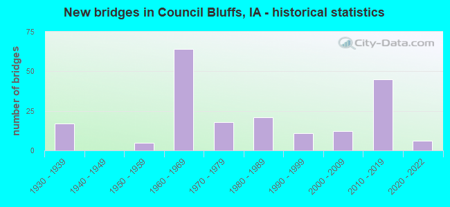
- New bridges - historical statistics
- 171930-1939
- 51950-1959
- 641960-1969
- 181970-1979
- 211980-1989
- 111990-1999
- 122000-2009
- 452010-2019
- 62020-2022
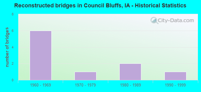
- Reconstructed bridges - Historical Statistics
- 61960-1969
- 11970-1979
- 21980-1989
- 11990-1999
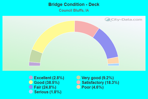
- Bridge Condition - Deck
- 2.8%Excellent
- 9.2%Very good
- 38.5%Good
- 18.3%Satisfactory
- 24.8%Fair
- 4.6%Poor
- 1.8%Serious
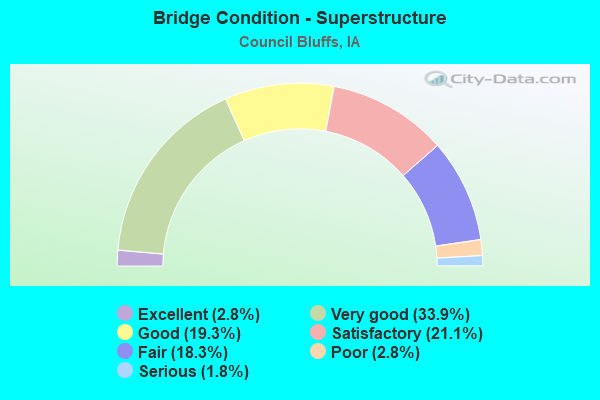
- Bridge Condition - Superstructure
- 2.8%Excellent
- 33.9%Very good
- 19.3%Good
- 21.1%Satisfactory
- 18.3%Fair
- 2.8%Poor
- 1.8%Serious
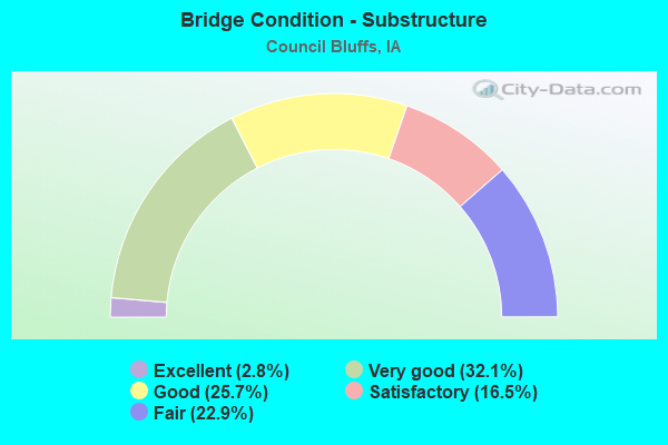
- Bridge Condition - Substructure
- 2.8%Excellent
- 32.1%Very good
- 25.7%Good
- 16.5%Satisfactory
- 22.9%Fair
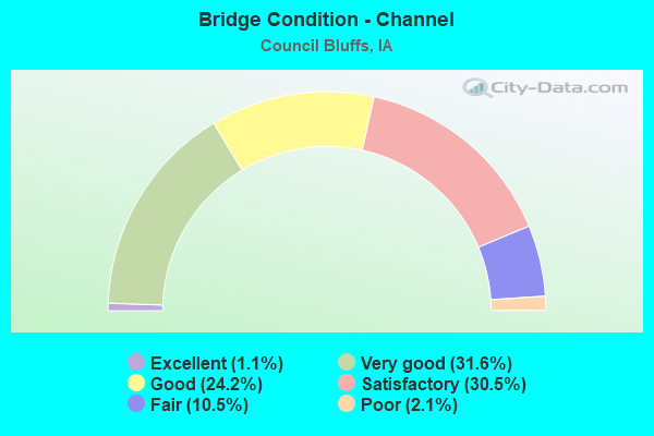
- Bridge Condition - Channel
- 1.1%Excellent
- 31.6%Very good
- 24.2%Good
- 30.5%Satisfactory
- 10.5%Fair
- 2.1%Poor
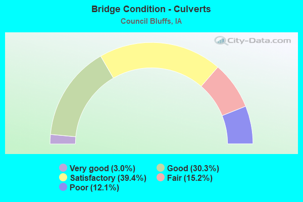
- Bridge Condition - Culverts
- 3.0%Very good
- 30.3%Good
- 39.4%Satisfactory
- 15.2%Fair
- 12.1%Poor
Find on map >> Show street view
Structure Number: 70001, Location: 0.7 MI. E OF 24th Street (Lat: 41.232569, Lng: -95.864383), Route carried "on" structure: Interstate 29, Year Built: 2014, Status: Open, Structure Length: 7.83m (25.69ft), Average Daily Traffic: 35,250 (year 2020), Truck Traffic: 19%, Average Future Daily Traffic: 35,250 (year 2041), Design Load: HL 93, Features Intersected: INDIAN CREEK
Minimum Vertical Clearance: 30+ m (98+ ft), Kilometerpoint: 80.604, Lanes on structure: 3, Base Highway Network: Yes, Owner: State Highway Agency, Approaching Roadway Width: 18.3m (60.0ft), Material/Design: Prestressed concrete, Design/Construction: Stringer/Multi-beam, Number Of Spans In Main Unit: 3, Length of Maximum Span: 31.1m (102.0ft), Curb-To-Curb Width: 18.3m (60.0ft), Out-to-Out Width: 19.3m (63.3ft)
Condition: Deck: Good, Superstructure: Very good, Substructure: Very good, Channel: Very good, Operating Rating: 42.1 metric tons, Method Used To Determine Operating Rating: Assigned ratings based on Load and Resistance Factor Design (LRFD) reported by rating factor (RF) using HL93 loadings, Inventory Rating: 32.4 metric tons, Method Used To Determine Inventory Rating: Assigned ratings based on Load and Resistance Factor Design (LRFD) reported by rating factor (RF) using HL93 loadings, Structural Evaluation: Equal to present desirable criteria, Deck Geometry: Better than present minimum criteria, Waterway Adequacy: Superior to present desirable criteria, Approach Roadway Alignment: Equal to present desirable criteria, Designated Inspection Frequency: Every 24 months, Inspection Date: August 2021, Deck Structure Type: Concrete Cast-file-Place, Wearing Surface/Protective System: Wearing Surface: Monolithic Concrete, Deck Protection: Epoxy Coated Reinforcing
Find on map >> Show street view
Structure Number: 700015, Location: 0.7 MI. E OF 24TH ST (Lat: 41.231978, Lng: -95.865389), Route carried "on" structure: Interstate 29, Year Built: 2018, Status: Open, Structure Length: 7.83m (25.69ft), Average Daily Traffic: 35,250 (year 2020), Truck Traffic: 19%, Average Future Daily Traffic: 35,250 (year 2041), Design Load: HL 93, Features Intersected: INDIAN CREEK
Minimum Vertical Clearance: 30+ m (98+ ft), Kilometerpoint: 163.965, Lanes on structure: 4, Owner: State Highway Agency, Approaching Roadway Width: 21.9m (71.9ft), Material/Design: Prestressed concrete, Design/Construction: Stringer/Multi-beam, Number Of Spans In Main Unit: 3, Length of Maximum Span: 31.1m (102.0ft), Curb-To-Curb Width: 21.9m (71.9ft), Out-to-Out Width: 22.9m (75.1ft)
Condition: Deck: Good, Superstructure: Very good, Substructure: Very good, Channel: Very good, Operating Rating: 42.1 metric tons, Method Used To Determine Operating Rating: Assigned ratings based on Load and Resistance Factor Design (LRFD) reported by rating factor (RF) using HL93 loadings, Inventory Rating: 32.4 metric tons, Method Used To Determine Inventory Rating: Assigned ratings based on Load and Resistance Factor Design (LRFD) reported by rating factor (RF) using HL93 loadings, Structural Evaluation: Equal to present desirable criteria, Deck Geometry: Better than present minimum criteria, Waterway Adequacy: Superior to present desirable criteria, Approach Roadway Alignment: Equal to present desirable criteria, Designated Inspection Frequency: Every 24 months, Inspection Date: August 2021, Deck Structure Type: Concrete Cast-file-Place, Wearing Surface/Protective System: Wearing Surface: Monolithic Concrete, Deck Protection: Epoxy Coated Reinforcing
Find on map >> Show street view
Structure Number: 700045, Location: I-80, I-29 AND RAMPS (Lat: 41.231119, Lng: -95.899178), Route carried "on" structure: Ramp Interstate 80, Year Built: 2014, Status: Open, Structure Length: 60.53m (198.59ft), Average Daily Traffic: 5,400 (year 2020), Truck Traffic: 14%, Average Future Daily Traffic: 5,400 (year 2040), Design Load: HL 93, Features Intersected: I80 & I29 INTERCHANGE
Minimum Vertical Clearance: 30+ m (98+ ft), Kilometerpoint: 0.583, Lanes on structure: 1, Lanes under structure: 17, Owner: State Highway Agency, Approaching Roadway Width: 9.8m (32.2ft), Material/Design: Steel continuous, Design/Construction: Stringer/Multi-beam, Number Of Spans In Main Unit: 12, Length of Maximum Span: 59.4m (194.9ft), Curb-To-Curb Width: 9.8m (32.2ft), Out-to-Out Width: 10.7m (35.1ft)
Condition: Deck: Very good, Superstructure: Very good, Substructure: Very good, Operating Rating: 46.7 metric tons, Method Used To Determine Operating Rating: Load and Resistance Factor Rating (LRFR) rating reported by rating factor(RF) method using HL-93 loadings, Inventory Rating: 36.0 metric tons, Method Used To Determine Inventory Rating: Load and Resistance Factor Rating (LRFR) rating reported by rating factor(RF) method using HL-93 loadings, Structural Evaluation: Equal to present desirable criteria, Deck Geometry: Superior to present desirable criteria, Underclear: Equal to present minimum criteria, Approach Roadway Alignment: Equal to present desirable criteria, Designated Inspection Frequency: Every 24 months, Inspection Date: October 2020, Deck Structure Type: Concrete Cast-file-Place, Wearing Surface/Protective System: Wearing Surface: Monolithic Concrete, Deck Protection: Epoxy Coated Reinforcing
Find on map >> Show street view
Structure Number: 70005, Location: I-80 AND RAMPS (Lat: 41.236572, Lng: -95.900519), Route carried "on" structure: Interstate 29, Year Built: 2014, Status: Open, Structure Length: 66.26m (217.39ft), Average Daily Traffic: 24,700 (year 2020), Truck Traffic: 15%, Average Future Daily Traffic: 24,700 (year 2040), Design Load: HL 93, Features Intersected: I-80 & I-29 INTERCHANGE
Minimum Vertical Clearance: 5.13m (16.83ft), Kilometerpoint: 160.741, Lanes on structure: 3, Lanes under structure: 11, Owner: State Highway Agency, Approaching Roadway Width: 18.6m (61.0ft), Material/Design: Steel continuous, Design/Construction: Stringer/Multi-beam, Number Of Spans In Main Unit: 11, Length of Maximum Span: 75.6m (248.0ft), Curb-To-Curb Width: 14.6m (47.9ft), Out-to-Out Width: 15.6m (51.2ft)
Condition: Deck: Good, Superstructure: Very good, Substructure: Very good, Operating Rating: 48.0 metric tons, Method Used To Determine Operating Rating: Load and Resistance Factor Rating (LRFR) rating reported by rating factor(RF) method using HL-93 loadings, Inventory Rating: 36.9 metric tons, Method Used To Determine Inventory Rating: Load and Resistance Factor Rating (LRFR) rating reported by rating factor(RF) method using HL-93 loadings, Structural Evaluation: Equal to present desirable criteria, Deck Geometry: Meets minimum limits, Underclear: Equal to present minimum criteria, Approach Roadway Alignment: Equal to present desirable criteria, Designated Inspection Frequency: Every 24 months, Inspection Date: October 2020, Deck Structure Type: Concrete Cast-file-Place, Wearing Surface/Protective System: Wearing Surface: Monolithic Concrete, Deck Protection: Epoxy Coated Reinforcing
Find on map >> Show street view
Structure Number: 70012, Location: N-E- CONNECTOR (Lat: 41.234042, Lng: -95.900078), Route carried "on" structure: US 6, Year Built: 2019, Status: Open, Structure Length: 32.83m (107.71ft), Average Daily Traffic: 26,100 (year 2020), Truck Traffic: 14%, Average Future Daily Traffic: 26,100 (year 2042), Design Load: HL 93, Features Intersected: US 6 TO I 80 EB
Minimum Vertical Clearance: 30+ m (98+ ft), Kilometerpoint: 4.204, Lanes on structure: 2, Lanes under structure: 9, Base Highway Network: Yes, Owner: State Highway Agency, Approaching Roadway Width: 12.8m (42.0ft), Material/Design: Steel continuous, Design/Construction: Stringer/Multi-beam, Number Of Spans In Main Unit: 5, Length of Maximum Span: 76.2m (250.0ft), Curb-To-Curb Width: 12.8m (42.0ft), Out-to-Out Width: 13.8m (45.3ft)
Condition: Deck: Very good, Superstructure: Very good, Substructure: Very good, Operating Rating: 48.0 metric tons, Method Used To Determine Operating Rating: Load and Resistance Factor Rating (LRFR) rating reported by rating factor(RF) method using HL-93 loadings, Inventory Rating: 36.9 metric tons, Method Used To Determine Inventory Rating: Load and Resistance Factor Rating (LRFR) rating reported by rating factor(RF) method using HL-93 loadings, Structural Evaluation: Equal to present desirable criteria, Deck Geometry: Equal to present desirable criteria, Underclear: Equal to present minimum criteria, Approach Roadway Alignment: Equal to present desirable criteria, Designated Inspection Frequency: Every 24 months, Inspection Date: January 2022, Deck Structure Type: Concrete Cast-file-Place, Wearing Surface/Protective System: Wearing Surface: Monolithic Concrete, Deck Protection: Epoxy Coated Reinforcing
Find on map >> Show street view
Structure Number: 70019, Location: At jct. I-29 (Lat: 41.221031, Lng: -95.831678), Route carried "on" structure: US 275, Year Built: 2015, Status: Open, Structure Length: 14.60m (47.90ft), Average Daily Traffic: 8,250 (year 2020), Truck Traffic: 7%, Average Future Daily Traffic: 8,250 (year 2041), Design Load: HL 93, Features Intersected: I 29
Minimum Vertical Clearance: 30+ m (98+ ft), Kilometerpoint: 86.863, Lanes on structure: 3, Lanes under structure: 8, Base Highway Network: Yes, Owner: State Highway Agency, Approaching Roadway Width: 12.2m (40.0ft), Skew: 20 degrees, Material/Design: Prestressed concrete, Design/Construction: Stringer/Multi-beam, Number Of Spans In Main Unit: 4, Length of Maximum Span: 46.0m (150.9ft), Curb-To-Curb Width: 12.8m (42.0ft), Out-to-Out Width: 14.4m (47.2ft)
Condition: Deck: Good, Superstructure: Very good, Substructure: Good, Operating Rating: 42.1 metric tons, Method Used To Determine Operating Rating: Assigned ratings based on Load and Resistance Factor Design (LRFD) reported by rating factor (RF) using HL93 loadings, Inventory Rating: 32.4 metric tons, Method Used To Determine Inventory Rating: Assigned ratings based on Load and Resistance Factor Design (LRFD) reported by rating factor (RF) using HL93 loadings, Structural Evaluation: Better than present minimum criteria, Deck Geometry: Meets minimum limits, Underclear: Equal to present minimum criteria, Approach Roadway Alignment: Equal to present desirable criteria, Designated Inspection Frequency: Every 24 months, Inspection Date: August 2021, Deck Structure Type: Concrete Cast-file-Place, Wearing Surface/Protective System: Wearing Surface: Monolithic Concrete, Deck Protection: Epoxy Coated Reinforcing
Find on map >> Show street view
Structure Number: 700195, Location: AT JCT OF I-29 (Lat: 41.220014, Lng: -95.832736), Route carried "on" structure: State highway 92, Year Built: 2016, Status: Open, Structure Length: 14.60m (47.90ft), Average Daily Traffic: 8,250 (year 2020), Truck Traffic: 7%, Average Future Daily Traffic: 8,250 (year 2041), Design Load: HL 93, Features Intersected: I 29
Minimum Vertical Clearance: 30+ m (98+ ft), Kilometerpoint: 8.222, Lanes on structure: 2, Lanes under structure: 8, Base Highway Network: Yes, Owner: State Highway Agency, Approaching Roadway Width: 11.6m (38.1ft), Skew: 20 degrees, Material/Design: Prestressed concrete, Design/Construction: Stringer/Multi-beam, Number Of Spans In Main Unit: 4, Length of Maximum Span: 46.0m (150.9ft), Curb-To-Curb Width: 11.3m (37.1ft), Out-to-Out Width: 16.0m (52.5ft)
Condition: Deck: Good, Superstructure: Very good, Substructure: Very good, Operating Rating: 42.1 metric tons, Method Used To Determine Operating Rating: Assigned ratings based on Load and Resistance Factor Design (LRFD) reported by rating factor (RF) using HL93 loadings, Inventory Rating: 32.4 metric tons, Method Used To Determine Inventory Rating: Assigned ratings based on Load and Resistance Factor Design (LRFD) reported by rating factor (RF) using HL93 loadings, Structural Evaluation: Equal to present desirable criteria, Deck Geometry: Equal to present minimum criteria, Underclear: Equal to present minimum criteria, Approach Roadway Alignment: Equal to present desirable criteria, Designated Inspection Frequency: Every 24 months, Inspection Date: August 2021, Deck Structure Type: Concrete Cast-file-Place, Wearing Surface/Protective System: Wearing Surface: Monolithic Concrete, Deck Protection: Epoxy Coated Reinforcing
Find on map >> Show street view
Structure Number: 70021, Location: 0.4 MI. S OF JCT. US 275 (Lat: 41.218069, Lng: -95.831019), Route carried "on" structure: Ramp US 275, Year Built: 2017, Status: Open, Structure Length: 3.92m (12.86ft), Average Daily Traffic: 2,450 (year 2020), Truck Traffic: 19%, Average Future Daily Traffic: 2,450 (year 2041), Design Load: HL 93, Features Intersected: MSE WALL, Facility Carried by Structure: I 29 SB ON RAMP
Minimum Vertical Clearance: 30+ m (98+ ft), Kilometerpoint: 8.362, Lanes on structure: 1, Owner: State Highway Agency, Approaching Roadway Width: 7.9m (25.9ft), Skew: 4 degrees, Material/Design: Steel, Design/Construction: Stringer/Multi-beam, Number Of Spans In Main Unit: 1, Length of Maximum Span: 37.9m (124.3ft), Curb-To-Curb Width: 7.9m (25.9ft), Out-to-Out Width: 8.9m (29.2ft)
Condition: Deck: Very good, Superstructure: Very good, Substructure: Very good, Operating Rating: 61.6 metric tons, Method Used To Determine Operating Rating: Load and Resistance Factor Rating (LRFR) rating reported by rating factor(RF) method using HL-93 loadings, Inventory Rating: 35.3 metric tons, Method Used To Determine Inventory Rating: Load and Resistance Factor Rating (LRFR) rating reported by rating factor(RF) method using HL-93 loadings, Structural Evaluation: Equal to present desirable criteria, Deck Geometry: Equal to present desirable criteria, Approach Roadway Alignment: Equal to present desirable criteria, Designated Inspection Frequency: Every 24 months, Inspection Date: October 2021, Deck Structure Type: Concrete Cast-file-Place, Wearing Surface/Protective System: Wearing Surface: Monolithic Concrete, Deck Protection: Epoxy Coated Reinforcing
Find on map >> Show street view
Structure Number: 700385, Location: 4.4 MI. E OF NE LINE (Lat: 41.232864, Lng: -95.830286), Route carried "on" structure: Interstate 80, Year Built: 2017, Status: Open, Structure Length: 102.35m (335.79ft), Average Daily Traffic: 19,100 (year 2020), Truck Traffic: 23%, Average Future Daily Traffic: 19,100 (year 2041), Design Load: HL 93, Features Intersected: I29 RR HARRY LANGDON BLV
Minimum Vertical Clearance: 6.63m (21.75ft), Kilometerpoint: 485.599, Lanes on structure: 3, Lanes under structure: 4, Owner: State Highway Agency, Approaching Roadway Width: 18.3m (60.0ft), Skew: 9 degrees, Material/Design: Steel continuous, Design/Construction: Stringer/Multi-beam, Number Of Spans In Main Unit: 16, Length of Maximum Span: 84.7m (277.9ft), Curb-To-Curb Width: 18.3m (60.0ft), Out-to-Out Width: 19.3m (63.3ft)
Condition: Deck: Good, Superstructure: Very good, Substructure: Very good, Channel: Very good, Operating Rating: 48.6 metric tons, Method Used To Determine Operating Rating: Load and Resistance Factor Rating (LRFR) rating reported by rating factor(RF) method using HL-93 loadings, Inventory Rating: 37.6 metric tons, Method Used To Determine Inventory Rating: Load and Resistance Factor Rating (LRFR) rating reported by rating factor(RF) method using HL-93 loadings, Structural Evaluation: Equal to present desirable criteria, Deck Geometry: Better than present minimum criteria, Underclear: Meets minimum limits, Approach Roadway Alignment: Equal to present desirable criteria, Designated Inspection Frequency: Every 24 months, Inspection Date: October 2021, Deck Structure Type: Concrete Cast-file-Place, Wearing Surface/Protective System: Wearing Surface: Monolithic Concrete, Deck Protection: Epoxy Coated Reinforcing
Find on map >> Show street view
Structure Number: 70039, Location: 4.0 MI. E OF NE LINE (Lat: 41.231917, Lng: -95.834928), Route carried "on" structure: Ramp Interstate 80, Year Built: 2017, Status: Open, Structure Length: 36.36m (119.29ft), Average Daily Traffic: 1,210 (year 2020), Truck Traffic: 29%, Average Future Daily Traffic: 1,210 (year 2041), Design Load: HL 93, Features Intersected: RR & DRAINAGE DITCH
Minimum Vertical Clearance: 5.59m (18.34ft), Kilometerpoint: 0.229, Lanes on structure: 2, Owner: State Highway Agency, Approaching Roadway Width: 12.8m (42.0ft), Skew: 3 degrees, Material/Design: Steel continuous, Design/Construction: Stringer/Multi-beam, Number Of Spans In Main Unit: 6, Length of Maximum Span: 81.9m (268.7ft), Curb-To-Curb Width: 12.8m (42.0ft), Out-to-Out Width: 13.8m (45.3ft)
Condition: Deck: Good, Superstructure: Very good, Substructure: Very good, Channel: Very good, Operating Rating: 42.8 metric tons, Method Used To Determine Operating Rating: Load and Resistance Factor Rating (LRFR) rating reported by rating factor(RF) method using HL-93 loadings, Inventory Rating: 33.0 metric tons, Method Used To Determine Inventory Rating: Load and Resistance Factor Rating (LRFR) rating reported by rating factor(RF) method using HL-93 loadings, Structural Evaluation: Equal to present desirable criteria, Deck Geometry: Superior to present desirable criteria, Underclear: Better than present minimum criteria, Waterway Adequacy: Superior to present desirable criteria, Approach Roadway Alignment: Equal to present desirable criteria, Designated Inspection Frequency: Every 24 months, Inspection Date: October 2021, Deck Structure Type: Concrete Cast-file-Place, Wearing Surface/Protective System: Wearing Surface: Monolithic Concrete, Deck Protection: Epoxy Coated Reinforcing
Find on map >> Show street view
Structure Number: 700395, Location: 4.0 MI. E. OF NEB. LINE (Lat: 41.232139, Lng: -95.833353), Route carried "on" structure: Ramp Interstate 80, Year Built: 2017, Status: Open, Structure Length: 112.11m (367.81ft), Average Daily Traffic: 2,200 (year 2020), Truck Traffic: 19%, Average Future Daily Traffic: 2,200 (year 2041), Design Load: HL 93, Features Intersected: I80 US 6 I29 & RR
Minimum Vertical Clearance: 30+ m (98+ ft), Kilometerpoint: 0.174, Lanes on structure: 1, Lanes under structure: 19, Owner: State Highway Agency, Approaching Roadway Width: 9.8m (32.2ft), Skew: 9 degrees, Material/Design: Steel continuous, Design/Construction: Stringer/Multi-beam, Number Of Spans In Main Unit: 19, Length of Maximum Span: 78.6m (257.9ft), Curb-To-Curb Width: 9.8m (32.2ft), Out-to-Out Width: 10.7m (35.1ft)
Condition: Deck: Good, Superstructure: Very good, Substructure: Very good, Channel: Excellent, Operating Rating: 43.7 metric tons, Method Used To Determine Operating Rating: Load and Resistance Factor Rating (LRFR) rating reported by rating factor(RF) method using HL-93 loadings, Inventory Rating: 33.7 metric tons, Method Used To Determine Inventory Rating: Load and Resistance Factor Rating (LRFR) rating reported by rating factor(RF) method using HL-93 loadings, Structural Evaluation: Equal to present desirable criteria, Deck Geometry: Superior to present desirable criteria, Underclear: Superior to present desirable criteria, Waterway Adequacy: Superior to present desirable criteria, Approach Roadway Alignment: Equal to present desirable criteria, Designated Inspection Frequency: Every 24 months, Inspection Date: October 2021, Deck Structure Type: Concrete Cast-file-Place, Wearing Surface/Protective System: Wearing Surface: Monolithic Concrete, Deck Protection: Epoxy Coated Reinforcing
Find on map >> Show street view
Structure Number: 7004, Location: I-80 EB VIADUCT (Lat: 41.232031, Lng: -95.842297), Route carried "on" structure: Interstate 80, Year Built: 2019, Status: Open, Structure Length: 10.27m (33.69ft), Average Daily Traffic: 16,400 (year 2020), Truck Traffic: 23%, Average Future Daily Traffic: 16,400 (year 2042), Design Load: HL 93, Features Intersected: I29 RR HARRY LANGDON BLV
Minimum Vertical Clearance: 7.24m (23.75ft), Kilometerpoint: 5.758, Lanes on structure: 3, Lanes under structure: 7, Base Highway Network: Yes, Owner: State Highway Agency, Approaching Roadway Width: 18.3m (60.0ft), Skew: 2 degrees, Material/Design: Steel continuous, Design/Construction: Stringer/Multi-beam, Number Of Spans In Main Unit: 17, Length of Maximum Span: 83.8m (274.9ft), Curb-To-Curb Width: 18.3m (60.0ft), Out-to-Out Width: 19.3m (63.3ft)
Condition: Deck: Good, Superstructure: Very good, Substructure: Very good, Channel: Very good, Operating Rating: 43.1 metric tons, Method Used To Determine Operating Rating: Load and Resistance Factor Rating (LRFR) rating reported by rating factor(RF) method using HL-93 loadings, Inventory Rating: 33.4 metric tons, Method Used To Determine Inventory Rating: Load and Resistance Factor Rating (LRFR) rating reported by rating factor(RF) method using HL-93 loadings, Structural Evaluation: Equal to present desirable criteria, Deck Geometry: Better than present minimum criteria, Underclear: Superior to present desirable criteria, Approach Roadway Alignment: Equal to present desirable criteria, Designated Inspection Frequency: Every 24 months, Inspection Date: March 2022, Deck Structure Type: Concrete Cast-file-Place, Wearing Surface/Protective System: Wearing Surface: Monolithic Concrete, Deck Protection: Epoxy Coated Reinforcing
Find on map >> Show street view
Structure Number: 700405, Location: I-29 TO I-80 EB RAMP D (Lat: 41.229942, Lng: -95.837353), Route carried "on" structure: Ramp Interstate 80, Year Built: 2019, Status: Open, Structure Length: 16.49m (54.10ft), Average Daily Traffic: 1,980 (year 2020), Truck Traffic: 19%, Average Future Daily Traffic: 1,980 (year 2040), Design Load: HL 93, Features Intersected: CBEC RR
Minimum Vertical Clearance: 30+ m (98+ ft), Kilometerpoint: 0.381, Lanes on structure: 1, Owner: State Highway Agency, Approaching Roadway Width: 9.1m (29.9ft), Material/Design: Steel continuous, Design/Construction: Stringer/Multi-beam, Number Of Spans In Main Unit: 3, Length of Maximum Span: 64.0m (210.0ft), Curb-To-Curb Width: 9.1m (29.9ft), Out-to-Out Width: 10.1m (33.1ft)
Condition: Deck: Very good, Superstructure: Very good, Substructure: Very good, Operating Rating: 47.3 metric tons, Method Used To Determine Operating Rating: Load and Resistance Factor Rating (LRFR) rating reported by rating factor(RF) method using HL-93 loadings, Inventory Rating: 36.6 metric tons, Method Used To Determine Inventory Rating: Load and Resistance Factor Rating (LRFR) rating reported by rating factor(RF) method using HL-93 loadings, Structural Evaluation: Equal to present desirable criteria, Deck Geometry: Superior to present desirable criteria, Underclear: Superior to present desirable criteria, Approach Roadway Alignment: Equal to present desirable criteria, Designated Inspection Frequency: Every 24 months, Inspection Date: June 2020, Deck Structure Type: Concrete Cast-file-Place, Wearing Surface/Protective System: Wearing Surface: Monolithic Concrete, Deck Protection: Epoxy Coated Reinforcing
Find on map >> Show street view
Structure Number: 70041, Location: I-29/I-80 RAMP F (Lat: 41.230425, Lng: -95.841947), Route carried "on" structure: Ramp Interstate 80, Year Built: 2019, Status: Open, Structure Length: 80.64m (264.57ft), Average Daily Traffic: 1,210 (year 2020), Truck Traffic: 29%, Average Future Daily Traffic: 1,210 (year 2040), Design Load: HL 93, Features Intersected: I 29 & CBEC RR
Minimum Vertical Clearance: 5.51m (18.08ft), Kilometerpoint: 1.254, Lanes on structure: 3, Lanes under structure: 7, Owner: State Highway Agency, Approaching Roadway Width: 14.6m (47.9ft), Material/Design: Steel continuous, Design/Construction: Stringer/Multi-beam, Number Of Spans In Main Unit: 13, Length of Maximum Span: 71.6m (234.9ft), Curb-To-Curb Width: 14.6m (47.9ft), Out-to-Out Width: 15.6m (51.2ft)
Condition: Deck: Excellent, Superstructure: Excellent, Substructure: Excellent, Operating Rating: 45.4 metric tons, Method Used To Determine Operating Rating: Load and Resistance Factor Rating (LRFR) rating reported by rating factor(RF) method using HL-93 loadings, Inventory Rating: 35.0 metric tons, Method Used To Determine Inventory Rating: Load and Resistance Factor Rating (LRFR) rating reported by rating factor(RF) method using HL-93 loadings, Structural Evaluation: Superior to present desirable criteria, Deck Geometry: Better than present minimum criteria, Underclear: Superior to present desirable criteria, Approach Roadway Alignment: Equal to present desirable criteria, Designated Inspection Frequency: Every 24 months, Inspection Date: November 2020, Deck Structure Type: Concrete Cast-file-Place, Wearing Surface/Protective System: Wearing Surface: Monolithic Concrete, Deck Protection: Epoxy Coated Reinforcing
Find on map >> Show street view
Structure Number: 700485, Location: E-W CONNECTOR (Lat: 41.233589, Lng: -95.894842), Route carried "on" structure: Ramp Interstate 80, Year Built: 2019, Status: Open, Structure Length: 28.06m (92.06ft), Average Daily Traffic: 6,400 (year 2020), Truck Traffic: 19%, Average Future Daily Traffic: 6,400 (year 2041), Design Load: HL 93, Features Intersected: I 29 NB
Minimum Vertical Clearance: 6.45m (21.16ft), Kilometerpoint: 0.465, Lanes on structure: 2, Lanes under structure: 5, Owner: State Highway Agency, Approaching Roadway Width: 12.8m (42.0ft), Material/Design: Steel continuous, Design/Construction: Stringer/Multi-beam, Number Of Spans In Main Unit: 5, Length of Maximum Span: 72.5m (237.9ft), Curb-To-Curb Width: 12.8m (42.0ft), Out-to-Out Width: 13.8m (45.3ft)
Condition: Deck: Very good, Superstructure: Very good, Substructure: Very good, Operating Rating: 46.7 metric tons, Method Used To Determine Operating Rating: Load and Resistance Factor Rating (LRFR) rating reported by rating factor(RF) method using HL-93 loadings, Inventory Rating: 36.0 metric tons, Method Used To Determine Inventory Rating: Load and Resistance Factor Rating (LRFR) rating reported by rating factor(RF) method using HL-93 loadings, Structural Evaluation: Equal to present desirable criteria, Deck Geometry: Superior to present desirable criteria, Underclear: Superior to present desirable criteria, Approach Roadway Alignment: Equal to present desirable criteria, Designated Inspection Frequency: Every 24 months, Inspection Date: September 2021, Deck Structure Type: Concrete Cast-file-Place, Wearing Surface/Protective System: Wearing Surface: Monolithic Concrete, Deck Protection: Epoxy Coated Reinforcing
Find on map >> Show street view
Structure Number: 70066, Location: AT JCT. 192 (Lat: 41.232725, Lng: -95.850881), Route carried "on" structure: Interstate 29, Year Built: 2017, Status: Open, Structure Length: 8.90m (29.20ft), Average Daily Traffic: 27,150 (year 2020), Truck Traffic: 21%, Average Future Daily Traffic: 27,150 (year 2041), Design Load: HL 93, Features Intersected: IA 192
Minimum Vertical Clearance: 30+ m (98+ ft), Kilometerpoint: 79.471, Lanes on structure: 5, Lanes under structure: 5, Base Highway Network: Yes, Owner: State Highway Agency, Approaching Roadway Width: 25.6m (84.0ft), Material/Design: Prestressed concrete, Design/Construction: Stringer/Multi-beam, Number Of Spans In Main Unit: 3, Length of Maximum Span: 47.9m (157.2ft), Curb-To-Curb Width: 24.8m (81.4ft), Out-to-Out Width: 25.8m (84.6ft)
Condition: Deck: Good, Superstructure: Very good, Substructure: Very good, Operating Rating: 42.1 metric tons, Method Used To Determine Operating Rating: Assigned ratings based on Load and Resistance Factor Design (LRFD) reported by rating factor (RF) using HL93 loadings, Inventory Rating: 32.4 metric tons, Method Used To Determine Inventory Rating: Assigned ratings based on Load and Resistance Factor Design (LRFD) reported by rating factor (RF) using HL93 loadings, Structural Evaluation: Equal to present desirable criteria, Deck Geometry: Better than present minimum criteria, Underclear: Equal to present minimum criteria, Approach Roadway Alignment: Equal to present desirable criteria, Designated Inspection Frequency: Every 24 months, Inspection Date: October 2021, Deck Structure Type: Concrete Cast-file-Place, Wearing Surface/Protective System: Wearing Surface: Monolithic Concrete, Deck Protection: Epoxy Coated Reinforcing
Find on map >> Show street view
Structure Number: 70067, Location: AT JCT. IA 192 (Lat: 41.231828, Lng: -95.851767), Route carried "on" structure: Ramp Interstate 80, Year Built: 2020, Status: Open, Structure Length: 8.90m (29.20ft), Average Daily Traffic: 2,460 (year 2020), Truck Traffic: 28%, Average Future Daily Traffic: 2,460 (year 2040), Design Load: HL 93, Features Intersected: IA 192, Facility Carried by Structure: I 29 SB ON RAMP
Minimum Vertical Clearance: 30+ m (98+ ft), Kilometerpoint: 0.401, Lanes on structure: 1, Lanes under structure: 5, Owner: State Highway Agency, Approaching Roadway Width: 8.5m (27.9ft), Material/Design: Prestressed concrete, Design/Construction: Stringer/Multi-beam, Number Of Spans In Main Unit: 3, Length of Maximum Span: 47.9m (157.2ft), Curb-To-Curb Width: 8.5m (27.9ft), Out-to-Out Width: 9.5m (31.2ft)
Condition: Deck: Excellent, Superstructure: Excellent, Substructure: Excellent, Operating Rating: 42.1 metric tons, Method Used To Determine Operating Rating: Assigned ratings based on Load and Resistance Factor Design (LRFD) reported by rating factor (RF) using HL93 loadings, Inventory Rating: 32.4 metric tons, Method Used To Determine Inventory Rating: Assigned ratings based on Load and Resistance Factor Design (LRFD) reported by rating factor (RF) using HL93 loadings, Structural Evaluation: Equal to present desirable criteria, Deck Geometry: Superior to present desirable criteria, Underclear: Better than present minimum criteria, Approach Roadway Alignment: Equal to present desirable criteria, Designated Inspection Frequency: Every 24 months, Inspection Date: November 2020, Deck Structure Type: Concrete Cast-file-Place, Wearing Surface/Protective System: Wearing Surface: Monolithic Concrete, Deck Protection: Epoxy Coated Reinforcing
Find on map >> Show street view
Structure Number: 3614, Location: AT JCT. OF I-29 (Lat: 41.149283, Lng: -95.822747), Route carried "under" structure: Interstate 29, Year Built: 1968, Structure Length: 0. m, Average Daily Traffic: 18,000 (year 2020), Truck Traffic: 23%, Features Intersected: I-29, Facility Carried by Structure: BUNGE AVE
Minimum Vertical Clearance: 30+ m (98+ ft), Kilometerpoint: 68.948, Lanes on structure: 2, Lanes under structure: 4, Material/Design: Prestressed concrete, Design/Construction: Stringer/Multi-beam, Length of Maximum Span: 21.0m (68.9ft)
Find on map >> Show street view
Structure Number: 3636, Location: 1.8 mi. S of Jct. SR H-10 (Lat: 41.123083, Lng: -95.822811), Route carried "under" structure: Interstate 29, Year Built: 1970, Structure Length: 0. m, Average Daily Traffic: 18,800 (year 2020), Truck Traffic: 23%, Features Intersected: I-29, Facility Carried by Structure: ALLIS ROAD
Minimum Vertical Clearance: 30+ m (98+ ft), Kilometerpoint: 66.009, Lanes on structure: 2, Lanes under structure: 4, Material/Design: Prestressed concrete, Design/Construction: Stringer/Multi-beam, Length of Maximum Span: 21.0m (68.9ft)
Find on map >> Show street view
Structure Number: 43131, Location: 3.2 MI. E. OF NEBR. LINE (Lat: 41.261844, Lng: -95.864075), Route carried "under" structure: City street , Year Built: 2011, Structure Length: 0. m, Average Daily Traffic: 2,531 (year 1998), Features Intersected: UP&CNIC RR & CITY STREET, Facility Carried by Structure: W BROADWAY
Minimum Vertical Clearance: 30+ m (98+ ft), Kilometerpoint: 0.021, Lanes on structure: 4, Lanes under structure: 8, Material/Design: Prestressed concrete, Design/Construction: Stringer/Multi-beam, Length of Maximum Span: 46.3m (151.9ft)
Find on map >> Show street view
Structure Number: 4457, Location: 2.6 mi. S of Jct. IA 92 (Lat: 41.189622, Lng: -95.824050), Route carried "under" structure: Interstate 29, Year Built: 1968, Structure Length: 0. m, Average Daily Traffic: 23,200 (year 2020), Truck Traffic: 22%, Features Intersected: I-29, Facility Carried by Structure: BASSWOOD RD
Minimum Vertical Clearance: 30+ m (98+ ft), Kilometerpoint: 73.423, Lanes on structure: 2, Lanes under structure: 4, Material/Design: Steel continuous, Design/Construction: Stringer/Multi-beam, Length of Maximum Span: 25.3m (83.0ft)
Find on map >> Show street view
Structure Number: 44651, Location: AT JCT. 192 (Lat: 41.232447, Lng: -95.850847), Route carried "under" structure: State highway 192, Year Built: 2017, Structure Length: 0. m, Average Daily Traffic: 11,250 (year 2020), Truck Traffic: 5%, Features Intersected: IA 192, Facility Carried by Structure: I 80 WB US 6 WB
Minimum Vertical Clearance: 30+ m (98+ ft), Kilometerpoint: 0.188, Lanes on structure: 4, Lanes under structure: 5, Material/Design: Prestressed concrete, Design/Construction: Stringer/Multi-beam, Length of Maximum Span: 47.9m (157.2ft)
Find on map >> Show street view
Structure Number: 44661, Location: AT JCT. IA 192 (Lat: 41.232025, Lng: -95.851786), Route carried "under" structure: State highway 192, Year Built: 2020, Structure Length: 0. m, Average Daily Traffic: 12,050 (year 2020), Truck Traffic: 7%, Features Intersected: IA 192, Facility Carried by Structure: I 29 SB
Minimum Vertical Clearance: 30+ m (98+ ft), Kilometerpoint: 0.140, Lanes on structure: 3, Lanes under structure: 5, Material/Design: Prestressed concrete, Design/Construction: Stringer/Multi-beam, Length of Maximum Span: 47.9m (157.2ft)
Find on map >> Show street view
Structure Number: 44691, Location: 1.7 mi. E of NE St. Line (Lat: 41.231878, Lng: -95.879161), Route carried "under" structure: Interstate 80, Year Built: 2008, Structure Length: 0. m, Average Daily Traffic: 53,000 (year 2020), Truck Traffic: 20%, Features Intersected: I 80 I 29 US 6, Facility Carried by Structure: 24TH ST
Minimum Vertical Clearance: 30+ m (98+ ft), Kilometerpoint: 2.643, Lanes on structure: 4, Lanes under structure: 6, Material/Design: Steel continuous, Design/Construction: Stringer/Multi-beam, Length of Maximum Span: 54.4m (178.5ft)
Find on map >> Show street view
Structure Number: 4472, Location: 1.4 MI. S OF JCT. US 6 (Lat: 41.241958, Lng: -95.904406), Route carried "under" structure: City street , Year Built: 1969, Structure Length: 0. m, Average Daily Traffic: 3,200 (year 2016), Features Intersected: NEBRASKA AVE & UPRR SPUR, Facility Carried by Structure: I 29 NB US 6 WB
Minimum Vertical Clearance: 30+ m (98+ ft), Kilometerpoint: 0.217, Lanes on structure: 2, Lanes under structure: 3, Material/Design: Prestressed concrete, Design/Construction: Stringer/Multi-beam, Length of Maximum Span: 19.8m (65.0ft)
Find on map >> Show street view
Structure Number: 44721, Location: 1.4 MI. S OF JCT. US 6 (Lat: 41.241928, Lng: -95.903922), Route carried "under" structure: City street , Year Built: 2021, Structure Length: 0. m, Average Daily Traffic: 3,200 (year 2016), Features Intersected: NEBRASKA AVE UP RR, Facility Carried by Structure: I 29 NB US 6 WB
Minimum Vertical Clearance: 30+ m (98+ ft), Kilometerpoint: 0.253, Lanes on structure: 5, Lanes under structure: 4, Material/Design: Steel continuous, Design/Construction: Stringer/Multi-beam, Length of Maximum Span: 53.0m (173.9ft)
Find on map >> Show street view
Structure Number: 4473, Location: 1.4 MI. S OF JCT. US 6 (Lat: 41.242328, Lng: -95.905133), Route carried "under" structure: City street , Year Built: 1969, Structure Length: 0. m, Average Daily Traffic: 3,200 (year 2016), Features Intersected: NEBR AVE & UPRR SPUR, Facility Carried by Structure: I 29 SB US 6 EB
Minimum Vertical Clearance: 30+ m (98+ ft), Kilometerpoint: 0.188, Lanes on structure: 3, Lanes under structure: 2, Material/Design: Prestressed concrete, Design/Construction: Stringer/Multi-beam, Length of Maximum Span: 19.8m (65.0ft)
Find on map >> Show street view
Structure Number: 4474, Location: 0.6 MI. S OF JCT. U.S. 6 (Lat: 41.253489, Lng: -95.906725), Route carried "under" structure: City street , Year Built: 1969, Structure Length: 0. m, Average Daily Traffic: 3,300 (year 2016), Features Intersected: 9TH AVE, Facility Carried by Structure: I 29 NB US 6 WB
Minimum Vertical Clearance: 30+ m (98+ ft), Kilometerpoint: 0.048, Lanes on structure: 2, Lanes under structure: 4, Material/Design: Prestressed concrete, Design/Construction: Stringer/Multi-beam, Length of Maximum Span: 18.6m (61.0ft)
Find on map >> Show street view
Structure Number: 4475, Location: 0.6 MI. S OF JCT. U.S. 6 (Lat: 41.253864, Lng: -95.906967), Route carried "under" structure: City street , Year Built: 1969, Structure Length: 0. m, Average Daily Traffic: 3,300 (year 2016), Features Intersected: 9TH AVE, Facility Carried by Structure: I 29 SB US 6 EB
Minimum Vertical Clearance: 30+ m (98+ ft), Kilometerpoint: 0.027, Lanes on structure: 2, Lanes under structure: 4, Material/Design: Prestressed concrete, Design/Construction: Stringer/Multi-beam, Length of Maximum Span: 18.6m (61.0ft)
Find on map >> Show street view
Structure Number: 4476, Location: 0.1 MI. S OF JCT. U.S. 6 (Lat: 41.259644, Lng: -95.907033), Route carried "under" structure: City street , Year Built: 1967, Structure Length: 0. m, Average Daily Traffic: 1,030 (year 2015), Features Intersected: 2ND AVE, Facility Carried by Structure: I 29 NB US 6 WB
Minimum Vertical Clearance: 30+ m (98+ ft), Kilometerpoint: 0.220, Lanes on structure: 2, Lanes under structure: 2, Material/Design: Steel continuous, Design/Construction: Stringer/Multi-beam, Length of Maximum Span: 15.9m (52.2ft)
Find on map >> Show street view
Structure Number: 4477, Location: 0.1 MI. S OF JCT. US 6 (Lat: 41.259853, Lng: -95.907756), Route carried "under" structure: City street , Year Built: 1967, Structure Length: 0. m, Average Daily Traffic: 1,030 (year 2015), Features Intersected: 2ND AVE, Facility Carried by Structure: I 29 SB US 6 EB
Minimum Vertical Clearance: 30+ m (98+ ft), Kilometerpoint: 0.164, Lanes on structure: 3, Lanes under structure: 2, Material/Design: Steel continuous, Design/Construction: Stringer/Multi-beam, Length of Maximum Span: 17.1m (56.1ft)
Find on map >> Show street view
Structure Number: 4479, Location: AT JCT US 6 & I-480 (Lat: 41.261617, Lng: -95.907339), Route carried "under" structure: Interstate 480, Year Built: 1965, Structure Length: 0. m, Average Daily Traffic: 15,700 (year 2020), Truck Traffic: 2%, Features Intersected: I 480, Facility Carried by Structure: I 29 NB
Minimum Vertical Clearance: 30+ m (98+ ft), Kilometerpoint: 1.186, Lanes on structure: 2, Lanes under structure: 6, Material/Design: Steel continuous, Design/Construction: Stringer/Multi-beam, Length of Maximum Span: 19.5m (64.0ft)
Find on map >> Show street view
Structure Number: 448, Location: AT JCT. I-480 (Lat: 41.262789, Lng: -95.909336), Route carried "under" structure: Interstate 480, Year Built: 1966, Structure Length: 0. m, Average Daily Traffic: 18,400 (year 2020), Truck Traffic: 2%, Features Intersected: I-480 & US 6 WB, Facility Carried by Structure: I 29 SB
Minimum Vertical Clearance: 30+ m (98+ ft), Kilometerpoint: 1.054, Lanes on structure: 2, Lanes under structure: 7, Material/Design: Steel continuous, Design/Construction: Stringer/Multi-beam, Length of Maximum Span: 22.3m (73.2ft)
Find on map >> Show street view
Structure Number: 4481, Location: 0.3 MI. N. OF JCT. US 6 (Lat: 41.267850, Lng: -95.908042), Route carried "under" structure: City street , Year Built: 1967, Structure Length: 0. m, Average Daily Traffic: 1,725 (year 2016), Features Intersected: AVE G, Facility Carried by Structure: NB I-29
Minimum Vertical Clearance: 30+ m (98+ ft), Kilometerpoint: 0.531, Lanes on structure: 2, Lanes under structure: 2, Material/Design: Steel continuous, Design/Construction: Stringer/Multi-beam, Length of Maximum Span: 16.5m (54.1ft)
Find on map >> Show street view
Structure Number: 4482, Location: 0.3 MI. N. OF JCT. U.S. 6 (Lat: 41.268269, Lng: -95.908131), Route carried "under" structure: City street , Year Built: 1967, Structure Length: 0. m, Average Daily Traffic: 1,725 (year 2016), Features Intersected: AVE G, Facility Carried by Structure: SB I-29
Minimum Vertical Clearance: 30+ m (98+ ft), Kilometerpoint: 0.507, Lanes on structure: 3, Lanes under structure: 2, Material/Design: Steel continuous, Design/Construction: Stringer/Multi-beam, Length of Maximum Span: 16.5m (54.1ft)
Find on map >> Show street view
Structure Number: 4483, Location: 1.0 MI. S OF IA 192 (Lat: 41.274881, Lng: -95.882050), Route carried "under" structure: City street , Year Built: 1967, Structure Length: 0. m, Average Daily Traffic: 2,105 (year 2016), Features Intersected: 25TH ST, Facility Carried by Structure: I 29 NB
Minimum Vertical Clearance: 30+ m (98+ ft), Kilometerpoint: 1.432, Lanes on structure: 2, Lanes under structure: 2, Material/Design: Prestressed concrete, Design/Construction: Stringer/Multi-beam, Length of Maximum Span: 23.5m (77.1ft)
Find on map >> Show street view
Structure Number: 4484, Location: 1.0 MI. S OF IA 192 (Lat: 41.275069, Lng: -95.881469), Route carried "under" structure: City street , Year Built: 1967, Structure Length: 0. m, Average Daily Traffic: 2,105 (year 2016), Features Intersected: 25TH ST, Facility Carried by Structure: I 29 SB
Minimum Vertical Clearance: 30+ m (98+ ft), Kilometerpoint: 1.456, Lanes on structure: 2, Lanes under structure: 2, Material/Design: Prestressed concrete, Design/Construction: Stringer/Multi-beam, Length of Maximum Span: 23.5m (77.1ft)
Find on map >> Show street view
Structure Number: 4487, Location: At N jct. of IA 192 (Lat: 41.285217, Lng: -95.867661), Route carried "under" structure: Interstate 29, Year Built: 1967, Structure Length: 0. m, Average Daily Traffic: 1,980 (year 2020), Truck Traffic: 7%, Features Intersected: SB IA 192
Minimum Vertical Clearance: 30+ m (98+ ft), Kilometerpoint: 0.270, Lanes on structure: 2, Lanes under structure: 2, Material/Design: Steel continuous, Design/Construction: Stringer/Multi-beam, Length of Maximum Span: 26.2m (86.0ft)
Find on map >> Show street view
Structure Number: 45082, Location: NEBR. STATE LINE (Lat: 41.231611, Lng: -95.910931), Route carried "under" structure: City street , Year Built: 1972, Structure Length: 0. m, Average Daily Traffic: 80 (year 2012), Features Intersected: MISSOURI RIVER, RD & RR, Facility Carried by Structure: I-80 EB
Minimum Vertical Clearance: 30+ m (98+ ft), Kilometerpoint: 1.109, Lanes on structure: 4, Lanes under structure: 2, Material/Design: Steel continuous, Design/Construction: Girder and Floorbeam System, Length of Maximum Span: 129.5m (424.9ft)
Find on map >> Show street view
Structure Number: 4517, Location: At Madison Ave. (Lat: 41.241858, Lng: -95.823789), Route carried "under" structure: City street , Year Built: 1968, Structure Length: 0. m, Average Daily Traffic: 5,500 (year 2016), Features Intersected: MADISON AVE, Facility Carried by Structure: EB I 80 & US 6
Minimum Vertical Clearance: 30+ m (98+ ft), Kilometerpoint: 0.473, Lanes on structure: 2, Lanes under structure: 3, Material/Design: Prestressed concrete, Design/Construction: Stringer/Multi-beam, Length of Maximum Span: 17.4m (57.1ft)
Find on map >> Show street view
Structure Number: 4518, Location: At Madison Ave. (Lat: 41.242328, Lng: -95.823714), Route carried "under" structure: City street , Year Built: 1968, Structure Length: 0. m, Average Daily Traffic: 5,500 (year 2016), Features Intersected: MADISON AVE, Facility Carried by Structure: WB I 80 & US 6
Minimum Vertical Clearance: 30+ m (98+ ft), Kilometerpoint: 0.497, Lanes on structure: 2, Lanes under structure: 4, Material/Design: Prestressed concrete, Design/Construction: Stringer/Multi-beam, Length of Maximum Span: 17.4m (57.1ft)
Find on map >> Show street view
Structure Number: 4519, Location: 3.2 MI. W OF US 6 (Lat: 41.244236, Lng: -95.820044), Route carried "under" structure: City street , Year Built: 1968, Structure Length: 0. m, Average Daily Traffic: 4,500 (year 2008), Features Intersected: BNSF RR,RD & CREEK, Facility Carried by Structure: EB I 80 & US 6
Minimum Vertical Clearance: 30+ m (98+ ft), Kilometerpoint: 3.862, Lanes on structure: 3, Lanes under structure: 2, Material/Design: Steel continuous, Design/Construction: Stringer/Multi-beam, Length of Maximum Span: 30.5m (100.1ft)
Find on map >> Show street view
Structure Number: 452, Location: 3.2 MI. W OF JCT. US 6 (Lat: 41.245192, Lng: -95.818206), Route carried "under" structure: City street , Year Built: 1968, Structure Length: 0. m, Average Daily Traffic: 4,450 (year 2012), Features Intersected: BNSF RR,RD & CREEK, Facility Carried by Structure: I 80 & US 6 WB
Minimum Vertical Clearance: 30+ m (98+ ft), Kilometerpoint: 3.833, Lanes on structure: 3, Lanes under structure: 2, Material/Design: Steel continuous, Design/Construction: Stringer/Multi-beam, Length of Maximum Span: 30.5m (100.1ft)
Find on map >> Show street view
Structure Number: 4521, Location: 2.3 MI. W OF JCT. US 6 (Lat: 41.253147, Lng: -95.809183), Route carried "under" structure: City street , Year Built: 1968, Structure Length: 0. m, Average Daily Traffic: 1,680 (year 2016), Features Intersected: FRANKLIN AVE, Facility Carried by Structure: EB I 80 & US 6
Minimum Vertical Clearance: 30+ m (98+ ft), Kilometerpoint: 1.727, Lanes on structure: 2, Lanes under structure: 2, Material/Design: Steel continuous, Design/Construction: Stringer/Multi-beam, Length of Maximum Span: 18.6m (61.0ft)
Find on map >> Show street view
Structure Number: 4522, Location: 2.3 MI. W OF JCT. US 6 (Lat: 41.253586, Lng: -95.809167), Route carried "under" structure: City street , Year Built: 1968, Structure Length: 0. m, Average Daily Traffic: 1,680 (year 2016), Features Intersected: FRANKLIN AVE, Facility Carried by Structure: WB I 80 & US 6
Minimum Vertical Clearance: 30+ m (98+ ft), Kilometerpoint: 1.756, Lanes on structure: 2, Lanes under structure: 2, Material/Design: Steel continuous, Design/Construction: Stringer/Multi-beam, Length of Maximum Span: 18.6m (61.0ft)
Find on map >> Show street view
Structure Number: 4523, Location: 1.6 mi. W of Jct. U.S. 6 (Lat: 41.260664, Lng: -95.803142), Route carried "under" structure: City street , Year Built: 1967, Structure Length: 0. m, Average Daily Traffic: 1,865 (year 2016), Features Intersected: MCPHERSON AVE, Facility Carried by Structure: EB I 80 & US 6
Minimum Vertical Clearance: 30+ m (98+ ft), Kilometerpoint: 2.969, Lanes on structure: 2, Lanes under structure: 2, Material/Design: Steel continuous, Design/Construction: Stringer/Multi-beam, Length of Maximum Span: 21.3m (69.9ft)
Find on map >> Show street view
Structure Number: 4524, Location: 1.6 mi. W of Jct. U.S. 6 (Lat: 41.261208, Lng: -95.803031), Route carried "under" structure: City street , Year Built: 1967, Structure Length: 0. m, Average Daily Traffic: 1,865 (year 2016), Features Intersected: MCPHERSON AVE, Facility Carried by Structure: WB I 80 & US 6
Minimum Vertical Clearance: 30+ m (98+ ft), Kilometerpoint: 2.937, Lanes on structure: 2, Lanes under structure: 2, Material/Design: Steel continuous, Design/Construction: Stringer/Multi-beam, Length of Maximum Span: 21.3m (69.9ft)
Find on map >> Show street view
Structure Number: 4526, Location: AT JCT US 6 (Lat: 41.279739, Lng: -95.784633), Route carried "under" structure: State highway 906, Year Built: 1967, Structure Length: 0. m, Average Daily Traffic: 3,300 (year 2020), Truck Traffic: 5%, Features Intersected: US 6, Facility Carried by Structure: I 80 EB
Minimum Vertical Clearance: 30+ m (98+ ft), Kilometerpoint: 6.317, Lanes on structure: 2, Lanes under structure: 4, Material/Design: Steel continuous, Design/Construction: Stringer/Multi-beam, Length of Maximum Span: 21.3m (69.9ft)
Find on map >> Show street view
Structure Number: 4527, Location: AT JCT US 6 (Lat: 41.280436, Lng: -95.784500), Route carried "under" structure: State highway 906, Year Built: 1967, Structure Length: 0. m, Average Daily Traffic: 3,300 (year 2020), Truck Traffic: 5%, Features Intersected: US 6, Facility Carried by Structure: I 80 WB
Minimum Vertical Clearance: 30+ m (98+ ft), Kilometerpoint: 6.289, Lanes on structure: 2, Lanes under structure: 4, Material/Design: Steel continuous, Design/Construction: Stringer/Multi-beam, Length of Maximum Span: 21.3m (69.9ft)
Find on map >> Show street view
Structure Number: 4568, Location: 0.4 MI. E OF NE ST. LINE (Lat: 41.261231, Lng: -95.914150), Route carried "under" structure: City street , Year Built: 1965, Structure Length: 0. m, Average Daily Traffic: 810 (year 2016), Features Intersected: 41ST STREET, Facility Carried by Structure: I 480 WB
Minimum Vertical Clearance: 30+ m (98+ ft), Kilometerpoint: 0.087, Lanes on structure: 4, Lanes under structure: 2, Material/Design: Steel continuous, Design/Construction: Stringer/Multi-beam, Length of Maximum Span: 18.3m (60.0ft)
Find on map >> Show street view
Structure Number: 50023, Location: 1.1 MI. N OF I-80 (Lat: 41.253528, Lng: -95.853992), Route carried "under" structure: City street , Year Built: 1976, Structure Length: 0. m, Average Daily Traffic: 5,500 (year 2008), Features Intersected: VIADUCT(RR & STREETS), Facility Carried by Structure: SOUTH EXPRESSWAY
Minimum Vertical Clearance: 30+ m (98+ ft), Kilometerpoint: 4.463, Lanes on structure: 2, Lanes under structure: 10, Material/Design: Steel continuous, Design/Construction: Stringer/Multi-beam, Length of Maximum Span: 41.5m (136.2ft)
Find on map >> Show street view
Structure Number: 50478, Location: Ave G over Railroads (Lat: 41.267983, Lng: -95.863736), Route carried "under" structure: City street , Year Built: 2006, Structure Length: 0. m, Average Daily Traffic: 21 (year 1978), Features Intersected: RRS, N 10TH AND N 13TH, Facility Carried by Structure: G AVENUE
Minimum Vertical Clearance: 30+ m (98+ ft), Kilometerpoint: 0.687, Lanes on structure: 2, Lanes under structure: 6, Material/Design: Steel continuous, Design/Construction: Stringer/Multi-beam, Length of Maximum Span: 54.9m (180.1ft)
Find on map >> Show street view
Structure Number: 60899, Location: 0.4 mi. E of NE St. line (Lat: 41.261008, Lng: -95.914583), Route carried "under" structure: City street , Year Built: 1965, Structure Length: 0. m, Average Daily Traffic: 810 (year 2016), Features Intersected: 41ST STREET, Facility Carried by Structure: I 480 EB
Minimum Vertical Clearance: 30+ m (98+ ft), Kilometerpoint: 0.063, Lanes on structure: 4, Lanes under structure: 2, Material/Design: Steel continuous, Design/Construction: Stringer/Multi-beam, Length of Maximum Span: 18.3m (60.0ft)
Find on map >> Show street view
Structure Number: 60909, Location: S. Expressway NB (Lat: 41.246403, Lng: -95.853928), Route carried "under" structure: City street , Year Built: 1976, Structure Length: 0. m, Average Daily Traffic: 2,750 (year 2008), Features Intersected: VIADUCT(OVER RR & STREET, Facility Carried by Structure: SOUTH EXPRESSWAY
Minimum Vertical Clearance: 30+ m (98+ ft), Kilometerpoint: 4.479, Lanes on structure: 2, Lanes under structure: 10, Material/Design: Steel continuous, Design/Construction: Stringer/Multi-beam, Length of Maximum Span: 41.5m (136.2ft)
Find on map >> Show street view
Structure Number: 60909, Location: S. Expressway NB (Lat: 41.246403, Lng: -95.853928), Route carried "under" structure: City street , Year Built: 1976, Structure Length: 0. m, Average Daily Traffic: 1,266 (year 1998), Features Intersected: VIADUCT(OVER RR & STREET, Facility Carried by Structure: SOUTH EXPRESSWAY
Minimum Vertical Clearance: 30+ m (98+ ft), Kilometerpoint: 2.168, Lanes on structure: 2, Lanes under structure: 10, Material/Design: Steel continuous, Design/Construction: Stringer/Multi-beam, Length of Maximum Span: 41.5m (136.2ft)
Find on map >> Show street view
Structure Number: 60909, Location: S. Expressway NB (Lat: 41.246403, Lng: -95.853928), Route carried "under" structure: City street , Year Built: 1976, Structure Length: 0. m, Average Daily Traffic: 2,110 (year 2012), Features Intersected: VIADUCT(OVER RR & STREET, Facility Carried by Structure: SOUTH EXPRESSWAY
Minimum Vertical Clearance: 30+ m (98+ ft), Kilometerpoint: 1.854, Lanes on structure: 2, Lanes under structure: 10, Material/Design: Steel continuous, Design/Construction: Stringer/Multi-beam, Length of Maximum Span: 41.5m (136.2ft)
Find on map >> Show street view
Structure Number: 60909, Location: S. Expressway NB (Lat: 41.246403, Lng: -95.853928), Route carried "under" structure: City street , Year Built: 1976, Structure Length: 0. m, Average Daily Traffic: 1,743 (year 2021), Features Intersected: VIADUCT(OVER RR & STREET, Facility Carried by Structure: SOUTH EXPRESSWAY
Minimum Vertical Clearance: 30+ m (98+ ft), Kilometerpoint: 2.073, Lanes on structure: 2, Lanes under structure: 10, Material/Design: Steel continuous, Design/Construction: Stringer/Multi-beam, Length of Maximum Span: 41.5m (136.2ft)
Find on map >> Show street view
Structure Number: 60909, Location: S. Expressway NB (Lat: 41.246403, Lng: -95.853928), Route carried "under" structure: City street , Year Built: 1976, Structure Length: 0. m, Average Daily Traffic: 1,266 (year 1998), Features Intersected: VIADUCT(OVER RR & STREET, Facility Carried by Structure: SOUTH EXPRESSWAY
Minimum Vertical Clearance: 30+ m (98+ ft), Kilometerpoint: 1.046, Lanes on structure: 2, Lanes under structure: 10, Material/Design: Steel continuous, Design/Construction: Stringer/Multi-beam, Length of Maximum Span: 41.5m (136.2ft)
Find on map >> Show street view
Structure Number: 609905, Location: NEBRASKA STATE LINE (Lat: 41.232328, Lng: -95.903986), Route carried "under" structure: City street , Year Built: 2010, Structure Length: 0. m, Average Daily Traffic: 80 (year 2012), Features Intersected: MISSOURI RVR, RD, RR, Facility Carried by Structure: I 80 WB
Minimum Vertical Clearance: 30+ m (98+ ft), Kilometerpoint: 1.138, Lanes on structure: 5, Material/Design: Steel, Design/Construction: Girder and Floorbeam System, Length of Maximum Span: 129.5m (424.9ft)
Find on map >> Show street view
Structure Number: 700045, Location: I-80, I-29 AND RAMPS (Lat: 41.231119, Lng: -95.899178), Route carried "under" structure: US 6, Year Built: 2014, Structure Length: 0. m, Average Daily Traffic: 26,100 (year 2020), Truck Traffic: 14%, Features Intersected: I80 & I29 INTERCHANGE, Facility Carried by Structure: I 80 EB TO I 29 NB
Minimum Vertical Clearance: 30+ m (98+ ft), Kilometerpoint: 513.944, Lanes on structure: 1, Lanes under structure: 17, Material/Design: Steel continuous, Design/Construction: Stringer/Multi-beam, Length of Maximum Span: 59.4m (194.9ft)
Find on map >> Show street view
Structure Number: 700045, Location: I-80, I-29 AND RAMPS (Lat: 41.231119, Lng: -95.899178), Route carried "under" structure: Interstate 29, Year Built: 2014, Structure Length: 0. m, Average Daily Traffic: 24,700 (year 2020), Truck Traffic: 15%, Features Intersected: I80 & I29 INTERCHANGE
Minimum Vertical Clearance: 30+ m (98+ ft), Kilometerpoint: 161.358, Lanes on structure: 1, Lanes under structure: 17, Material/Design: Steel continuous, Design/Construction: Stringer/Multi-beam, Length of Maximum Span: 59.4m (194.9ft)
Find on map >> Show street view
Structure Number: 700045, Location: I-80, I-29 AND RAMPS (Lat: 41.231119, Lng: -95.899178), Route carried "under" structure: Interstate 80, Year Built: 2014, Structure Length: 0. m, Average Daily Traffic: 47,000 (year 2020), Truck Traffic: 21%, Features Intersected: I80 & I29 INTERCHANGE
Minimum Vertical Clearance: 30+ m (98+ ft), Kilometerpoint: 1.244, Lanes on structure: 1, Lanes under structure: 17, Material/Design: Steel continuous, Design/Construction: Stringer/Multi-beam, Length of Maximum Span: 59.4m (194.9ft)
Find on map >> Show street view
Structure Number: 70005, Location: I-80 AND RAMPS (Lat: 41.236572, Lng: -95.900519), Route carried "under" structure: Interstate 80, Year Built: 2014, Structure Length: 0. m, Average Daily Traffic: 47,000 (year 2020), Truck Traffic: 21%, Features Intersected: I-80 & I-29 INTERCHANGE, Facility Carried by Structure: I 29 SB
Minimum Vertical Clearance: 30+ m (98+ ft), Kilometerpoint: 1.147, Lanes on structure: 3, Lanes under structure: 11, Material/Design: Steel continuous, Design/Construction: Stringer/Multi-beam, Length of Maximum Span: 75.6m (248.0ft)
Find on map >> Show street view
Structure Number: 70012, Location: N-E- CONNECTOR (Lat: 41.234042, Lng: -95.900078), Route carried "under" structure: Interstate 80, Year Built: 2019, Structure Length: 0. m, Average Daily Traffic: 47,000 (year 2020), Truck Traffic: 21%, Features Intersected: US 6 TO I 80 EB, Facility Carried by Structure: US 6
Minimum Vertical Clearance: 30+ m (98+ ft), Kilometerpoint: 1.025, Lanes on structure: 2, Lanes under structure: 9, Material/Design: Steel continuous, Design/Construction: Stringer/Multi-beam, Length of Maximum Span: 76.2m (250.0ft)
Find on map >> Show street view
Structure Number: 70019, Location: At jct. I-29 (Lat: 41.221031, Lng: -95.831678), Route carried "under" structure: Interstate 29, Year Built: 2015, Structure Length: 0. m, Average Daily Traffic: 11,150 (year 2020), Truck Traffic: 23%, Features Intersected: I 29, Facility Carried by Structure: US 275 NB IA 92 WB
Minimum Vertical Clearance: 30+ m (98+ ft), Kilometerpoint: 77.134, Lanes on structure: 3, Lanes under structure: 8, Material/Design: Prestressed concrete, Design/Construction: Stringer/Multi-beam, Length of Maximum Span: 46.0m (150.9ft)
Find on map >> Show street view
Structure Number: 700195, Location: AT JCT OF I-29 (Lat: 41.220014, Lng: -95.832736), Route carried "under" structure: Interstate 29, Year Built: 2016, Structure Length: 0. m, Average Daily Traffic: 9,400 (year 2020), Truck Traffic: 22%, Features Intersected: I 29, Facility Carried by Structure: IA 92 EB
Minimum Vertical Clearance: 30+ m (98+ ft), Kilometerpoint: 77.118, Lanes on structure: 2, Lanes under structure: 8, Material/Design: Prestressed concrete, Design/Construction: Stringer/Multi-beam, Length of Maximum Span: 46.0m (150.9ft)
Find on map >> Show street view
Structure Number: 700385, Location: 4.4 MI. E OF NE LINE (Lat: 41.232864, Lng: -95.830286), Route carried "under" structure: Ramp Interstate 29, Year Built: 2017, Structure Length: 0. m, Average Daily Traffic: 1,210 (year 2020), Truck Traffic: 29%, Features Intersected: I29 RR HARRY LANGDON BLV, Facility Carried by Structure: I 80 WB US 6 WB
Minimum Vertical Clearance: 30+ m (98+ ft), Kilometerpoint: 78.599, Lanes on structure: 3, Lanes under structure: 4, Material/Design: Steel continuous, Design/Construction: Stringer/Multi-beam, Length of Maximum Span: 84.7m (277.9ft)
Find on map >> Show street view
Structure Number: 700395, Location: 4.0 MI. E. OF NEB. LINE (Lat: 41.232139, Lng: -95.833353), Route carried "under" structure: Interstate 80, Year Built: 2017, Structure Length: 0. m, Average Daily Traffic: 32,800 (year 2020), Truck Traffic: 23%, Features Intersected: I80 US 6 I29 & RR
Minimum Vertical Clearance: 30+ m (98+ ft), Kilometerpoint: 5.953, Lanes on structure: 1, Lanes under structure: 19, Material/Design: Steel continuous, Design/Construction: Stringer/Multi-beam, Length of Maximum Span: 78.6m (257.9ft)