Bridge Statistics for Council Bluffs, Iowa (IA)
Condition, Traffic, Stress, Structural Evaluation, Project Costs
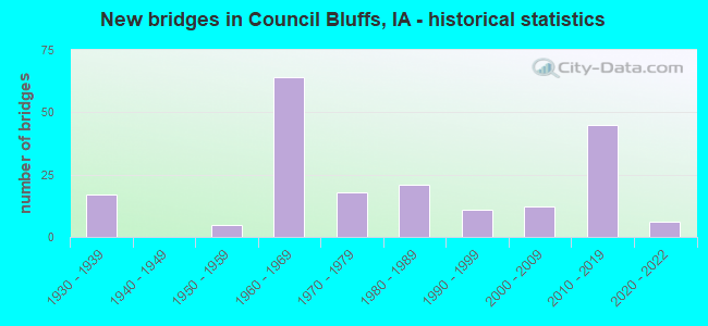
- New bridges - historical statistics
- 171930-1939
- 51950-1959
- 641960-1969
- 181970-1979
- 211980-1989
- 111990-1999
- 122000-2009
- 452010-2019
- 62020-2022
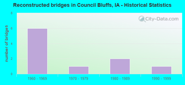
- Reconstructed bridges - Historical Statistics
- 61960-1969
- 11970-1979
- 21980-1989
- 11990-1999
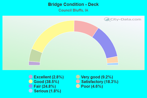
- Bridge Condition - Deck
- 2.8%Excellent
- 9.2%Very good
- 38.5%Good
- 18.3%Satisfactory
- 24.8%Fair
- 4.6%Poor
- 1.8%Serious
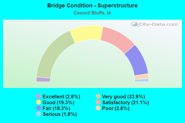
- Bridge Condition - Superstructure
- 2.8%Excellent
- 33.9%Very good
- 19.3%Good
- 21.1%Satisfactory
- 18.3%Fair
- 2.8%Poor
- 1.8%Serious
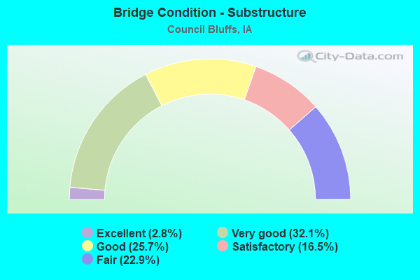
- Bridge Condition - Substructure
- 2.8%Excellent
- 32.1%Very good
- 25.7%Good
- 16.5%Satisfactory
- 22.9%Fair
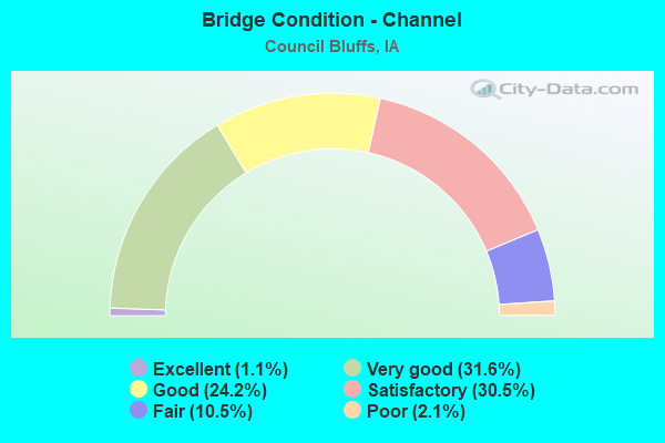
- Bridge Condition - Channel
- 1.1%Excellent
- 31.6%Very good
- 24.2%Good
- 30.5%Satisfactory
- 10.5%Fair
- 2.1%Poor
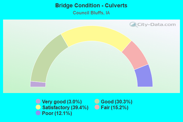
- Bridge Condition - Culverts
- 3.0%Very good
- 30.3%Good
- 39.4%Satisfactory
- 15.2%Fair
- 12.1%Poor
Find on map >> Show street view
Structure Number: 7004, Location: I-80 EB VIADUCT (Lat: 41.232031, Lng: -95.842297), Route carried "under" structure: Ramp Interstate 29, Year Built: 2019, Structure Length: 0. m, Average Daily Traffic: 605 (year 2020), Truck Traffic: 29%, Features Intersected: I29 RR HARRY LANGDON BLV, Facility Carried by Structure: I 80 US 6 EB
Minimum Vertical Clearance: 30+ m (98+ ft), Kilometerpoint: 78.575, Lanes on structure: 3, Lanes under structure: 7, Material/Design: Steel continuous, Design/Construction: Stringer/Multi-beam, Length of Maximum Span: 83.8m (274.9ft)
Find on map >> Show street view
Structure Number: 70041, Location: I-29/I-80 RAMP F (Lat: 41.230425, Lng: -95.841947), Route carried "under" structure: Interstate 29, Year Built: 2019, Structure Length: 0. m, Average Daily Traffic: 1,210 (year 2020), Truck Traffic: 29%, Features Intersected: I 29 & CBEC RR
Minimum Vertical Clearance: 30+ m (98+ ft), Kilometerpoint: 78.330, Lanes on structure: 3, Lanes under structure: 7, Material/Design: Steel continuous, Design/Construction: Stringer/Multi-beam, Length of Maximum Span: 71.6m (234.9ft)
Find on map >> Show street view
Structure Number: 700485, Location: E-W CONNECTOR (Lat: 41.233589, Lng: -95.894842), Route carried "under" structure: Interstate 29, Year Built: 2019, Structure Length: 0. m, Average Daily Traffic: 24,700 (year 2020), Truck Traffic: 15%, Features Intersected: I 29 NB
Minimum Vertical Clearance: 30+ m (98+ ft), Kilometerpoint: 83.317, Lanes on structure: 2, Lanes under structure: 5, Material/Design: Steel continuous, Design/Construction: Stringer/Multi-beam, Length of Maximum Span: 72.5m (237.9ft)
Find on map >> Show street view
Structure Number: 70066, Location: AT JCT. 192 (Lat: 41.232725, Lng: -95.850881), Route carried "under" structure: State highway 192, Year Built: 2017, Structure Length: 0. m, Average Daily Traffic: 11,250 (year 2020), Truck Traffic: 5%, Features Intersected: IA 192, Facility Carried by Structure: I 29 NB
Minimum Vertical Clearance: 30+ m (98+ ft), Kilometerpoint: 0.222, Lanes on structure: 5, Lanes under structure: 5, Material/Design: Prestressed concrete, Design/Construction: Stringer/Multi-beam, Length of Maximum Span: 47.9m (157.2ft)
Find on map >> Show street view
Structure Number: 700665, Location: I-80 EB over IA 92 (Lat: 41.232214, Lng: -95.851731), Route carried "under" structure: State highway 192, Year Built: 2019, Structure Length: 0. m, Average Daily Traffic: 11,250 (year 2020), Truck Traffic: 5%, Features Intersected: IA 192, Facility Carried by Structure: I 80 US 6 EB
Minimum Vertical Clearance: 30+ m (98+ ft), Kilometerpoint: 0.166, Lanes on structure: 3, Lanes under structure: 4, Material/Design: Prestressed concrete, Design/Construction: Stringer/Multi-beam, Length of Maximum Span: 47.9m (157.2ft)
Find on map >> Show street view
Structure Number: 70067, Location: AT JCT. IA 192 (Lat: 41.231828, Lng: -95.851767), Route carried "under" structure: State highway 192, Year Built: 2020, Structure Length: 0. m, Average Daily Traffic: 24,100 (year 2020), Truck Traffic: 7%, Features Intersected: IA 192, Facility Carried by Structure: I 29 SB ON RAMP
Minimum Vertical Clearance: 30+ m (98+ ft), Kilometerpoint: 0.127, Lanes on structure: 1, Lanes under structure: 5, Material/Design: Prestressed concrete, Design/Construction: Stringer/Multi-beam, Length of Maximum Span: 47.9m (157.2ft)