Bridge Statistics for Denton, Texas (TX)
Condition, Traffic, Stress, Structural Evaluation, Project Costs
- National Bridge Inventory (NBI) Statistics
- 296Number of bridges
- 3,894ft / 1,187mTotal length
- $742,000Total costs
- 4,491,088Total average daily traffic
- 543,508Total average daily truck traffic
- National Bridge Inventory (NBI) Registered Bridges for Denton
- No street view available for this location
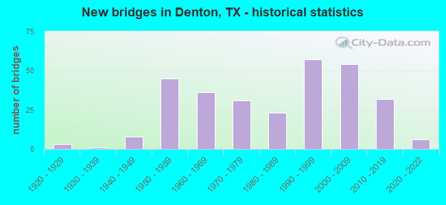
- New bridges - historical statistics
- 31920-1929
- 11930-1939
- 81940-1949
- 451950-1959
- 361960-1969
- 311970-1979
- 231980-1989
- 571990-1999
- 542000-2009
- 322010-2019
- 62020-2022
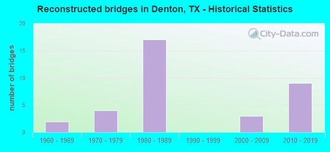
- Reconstructed bridges - Historical Statistics
- 21960-1969
- 41970-1979
- 171980-1989
- 01990-1999
- 32000-2009
- 92010-2019
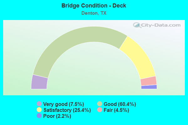
- Bridge Condition - Deck
- 7.5%Very good
- 60.4%Good
- 25.4%Satisfactory
- 4.5%Fair
- 2.2%Poor
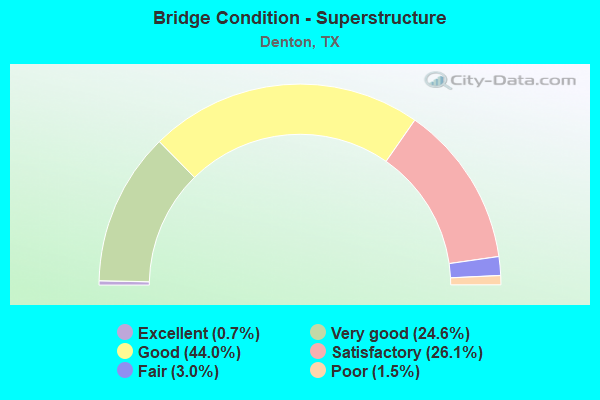
- Bridge Condition - Superstructure
- 0.7%Excellent
- 24.6%Very good
- 44.0%Good
- 26.1%Satisfactory
- 3.0%Fair
- 1.5%Poor
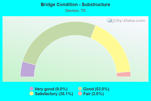
- Bridge Condition - Substructure
- 9.0%Very good
- 53.0%Good
- 35.1%Satisfactory
- 3.0%Fair
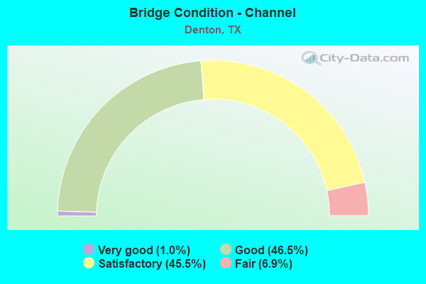
- Bridge Condition - Channel
- 1.0%Very good
- 46.5%Good
- 45.5%Satisfactory
- 6.9%Fair
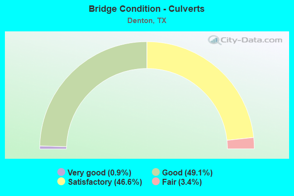
- Bridge Condition - Culverts
- 0.9%Very good
- 49.1%Good
- 46.6%Satisfactory
- 3.4%Fair
Find on map >> Show street view
Structure Number: 18061000810304, Location: 3.60 MI N OF FM 407 (Lat: 33.146378, Lng: -97.169978), Route carried "on" structure: US 377, Year Built: 1942, Status: Open, Structure Length: 0.82m (2.69ft), Average Daily Traffic: 6,879 (year 2020), Truck Traffic: 11%, Average Future Daily Traffic: 11,780 (year 2033), Features Intersected: TRIB OF GRAVEYARD BRANCH
Minimum Vertical Clearance: 30+ m (98+ ft), Kilometerpoint: 2.942, Lanes on structure: 2, Owner: State Highway Agency, Approaching Roadway Width: 13.1m (43.0ft), Skew: 3 degrees, Material/Design: Concrete, Design/Construction: Culvert, Number Of Spans In Main Unit: 2, Length of Maximum Span: 3.0m (9.8ft), Curb-To-Curb Width: 13.4m (44.0ft), Out-to-Out Width: 16.2m (53.1ft)
Condition: Channel: Good, Culverts: Satisfactory, Operating Rating: 32.7 metric tons, Method Used To Determine Operating Rating: Field evaluation and documented engineering judgment, Inventory Rating: 24.5 metric tons, Method Used To Determine Inventory Rating: Field evaluation and documented engineering judgment, Structural Evaluation: Equal to present minimum criteria, Deck Geometry: Equal to present minimum criteria, Waterway Adequacy: Equal to present minimum criteria, Approach Roadway Alignment: Equal to present desirable criteria, Designated Inspection Frequency: Every 24 months, Inspection Date: August 2021, Deck Structure Type: Concrete Cast-file-Place, Wearing Surface/Protective System: Wearing Surface: Bituminous
Find on map >> Show street view
Structure Number: 180610008103041, Location: 2.75 MI S OF IH 35E (Lat: 33.162908, Lng: -97.158569), Route carried "on" structure: US 377, Year Built: 1942, Year Reconstructed: 2015, Status: Open, Structure Length: 4.11m (13.48ft), Average Daily Traffic: 6,879 (year 2020), Truck Traffic: 11%, Average Future Daily Traffic: 11,780 (year 2033), Design Load: HL 93, Features Intersected: ROARK BRANCH
Minimum Vertical Clearance: 30+ m (98+ ft), Kilometerpoint: 0.822, Lanes on structure: 2, Owner: State Highway Agency, Approaching Roadway Width: 15.9m (52.2ft), Skew: 3 degrees, Material/Design: Steel, Design/Construction: Stringer/Multi-beam, Number Of Spans In Main Unit: 3, Length of Maximum Span: 13.7m (44.9ft), Curb-To-Curb Width: 15.9m (52.2ft), Out-to-Out Width: 16.5m (54.1ft)
Condition: Deck: Very good, Superstructure: Good, Substructure: Good, Channel: Good, Operating Rating: 54.4 metric tons, Method Used To Determine Operating Rating: Assigned ratings based on Load and Resistance Factor Design (LRFD) reported in metric tons, Inventory Rating: 32.7 metric tons, Method Used To Determine Inventory Rating: Assigned ratings based on Load and Resistance Factor Design (LRFD) reported in metric tons, Structural Evaluation: Better than present minimum criteria, Deck Geometry: Superior to present desirable criteria, Waterway Adequacy: Equal to present minimum criteria, Approach Roadway Alignment: Equal to present desirable criteria, Length Of Structure Improvement: 4.11m (13.48ft), Designated Inspection Frequency: Every 24 months, Inspection Date: September 2021, Bridge Improvement Cost: $7,000, Roadway Improvement Cost: $2,000, Total Project Cost: $9,000, Deck Structure Type: Concrete Cast-file-Place
Find on map >> Show street view
Structure Number: 180610008103042, Location: 2.55 MI S OF IH 35E (Lat: 33.164972, Lng: -97.156156), Route carried "on" structure: US 377, Year Built: 1942, Year Reconstructed: 2015, Status: Open, Structure Length: 4.11m (13.48ft), Average Daily Traffic: 6,879 (year 2020), Truck Traffic: 11%, Average Future Daily Traffic: 11,780 (year 2033), Design Load: HL 93, Features Intersected: HICKORY CREEK RELIEF
Minimum Vertical Clearance: 30+ m (98+ ft), Kilometerpoint: 0.501, Lanes on structure: 2, Owner: State Highway Agency, Approaching Roadway Width: 15.9m (52.2ft), Skew: 20 degrees, Material/Design: Steel, Design/Construction: Stringer/Multi-beam, Number Of Spans In Main Unit: 3, Length of Maximum Span: 13.7m (44.9ft), Curb-To-Curb Width: 15.9m (52.2ft), Out-to-Out Width: 16.5m (54.1ft)
Condition: Deck: Good, Superstructure: Satisfactory, Substructure: Fair, Channel: Satisfactory, Operating Rating: 54.4 metric tons, Method Used To Determine Operating Rating: Assigned ratings based on Load and Resistance Factor Design (LRFD) reported in metric tons, Inventory Rating: 32.7 metric tons, Method Used To Determine Inventory Rating: Assigned ratings based on Load and Resistance Factor Design (LRFD) reported in metric tons, Structural Evaluation: Somewhat better than minimum adequacy, Deck Geometry: Superior to present desirable criteria, Waterway Adequacy: Equal to present minimum criteria, Approach Roadway Alignment: Equal to present desirable criteria, Length Of Structure Improvement: 4.11m (13.48ft), Designated Inspection Frequency: Every 24 months, Inspection Date: September 2021, Bridge Improvement Cost: $7,000, Roadway Improvement Cost: $2,000, Total Project Cost: $9,000, Deck Structure Type: Concrete Cast-file-Place
Find on map >> Show street view
Structure Number: 180610008103043, Location: 2.30 MI S OF IH 35E (Lat: 33.168075, Lng: -97.152553), Route carried "on" structure: US 377, Year Built: 1942, Year Reconstructed: 2015, Status: Open, Structure Length: 6.00m (19.69ft), Average Daily Traffic: 6,879 (year 2020), Truck Traffic: 11%, Average Future Daily Traffic: 11,780 (year 2033), Design Load: HL 93, Features Intersected: HICKORY CREEK
Minimum Vertical Clearance: 30+ m (98+ ft), Kilometerpoint: 0.000, Lanes on structure: 2, Owner: State Highway Agency, Approaching Roadway Width: 16.5m (54.1ft), Material/Design: Steel continuous, Design/Construction: Stringer/Multi-beam, Number Of Spans In Main Unit: 3, Length of Maximum Span: 22.9m (75.1ft), Curb-To-Curb Width: 16.5m (54.1ft), Out-to-Out Width: 17.1m (56.1ft)
Condition: Deck: Good, Superstructure: Good, Substructure: Good, Channel: Satisfactory, Operating Rating: 54.4 metric tons, Method Used To Determine Operating Rating: Assigned ratings based on Load and Resistance Factor Design (LRFD) reported in metric tons, Inventory Rating: 32.7 metric tons, Method Used To Determine Inventory Rating: Assigned ratings based on Load and Resistance Factor Design (LRFD) reported in metric tons, Structural Evaluation: Better than present minimum criteria, Deck Geometry: Superior to present desirable criteria, Waterway Adequacy: Equal to present minimum criteria, Approach Roadway Alignment: Equal to present desirable criteria, Length Of Structure Improvement: 6.00m (19.69ft), Designated Inspection Frequency: Every 24 months, Inspection Date: September 2021, Bridge Improvement Cost: $10,000, Roadway Improvement Cost: $3,000, Total Project Cost: $13,000, Deck Structure Type: Concrete Cast-file-Place
Find on map >> Show street view
Structure Number: 180610008104044, Location: 2.05 MI S OF IH 35E (Lat: 33.170061, Lng: -97.150269), Route carried "on" structure: US 377, Year Built: 1942, Status: Open, Structure Length: 0.76m (2.49ft), Average Daily Traffic: 31,460 (year 2010), Truck Traffic: 15%, Average Future Daily Traffic: 44,310 (year 2029), Features Intersected: DRAW
Minimum Vertical Clearance: 30+ m (98+ ft), Kilometerpoint: 0.946, Lanes on structure: 2, Owner: State Highway Agency, Approaching Roadway Width: 13.4m (44.0ft), Skew: 3 degrees, Material/Design: Concrete, Design/Construction: Culvert, Number Of Spans In Main Unit: 2, Length of Maximum Span: 3.0m (9.8ft), Curb-To-Curb Width: 14.0m (45.9ft), Out-to-Out Width: 15.5m (50.9ft)
Condition: Channel: Satisfactory, Culverts: Good, Operating Rating: 32.7 metric tons, Method Used To Determine Operating Rating: Field evaluation and documented engineering judgment, Inventory Rating: 24.5 metric tons, Method Used To Determine Inventory Rating: Field evaluation and documented engineering judgment, Structural Evaluation: Equal to present minimum criteria, Deck Geometry: Superior to present desirable criteria, Waterway Adequacy: Equal to present minimum criteria, Approach Roadway Alignment: Equal to present desirable criteria, Designated Inspection Frequency: Every 24 months, Inspection Date: September 2021, Deck Structure Type: Concrete Cast-file-Place, Wearing Surface/Protective System: Wearing Surface: Bituminous
Find on map >> Show street view
Structure Number: 180610008105016, Location: 0.90 MI S OF LP 288 (Lat: 33.245972, Lng: -97.117769), Route carried "on" structure: State highway 428, Year Built: 1921, Year Reconstructed: 1960, Status: Posted for load, Structure Length: 1.01m (3.31ft), Average Daily Traffic: 8,393 (year 2020), Truck Traffic: 14%, Average Future Daily Traffic: 8,820 (year 2033), Features Intersected: COOPER CREEK
Minimum Vertical Clearance: 30+ m (98+ ft), Kilometerpoint: 4.038, Lanes on structure: 4, Owner: State Highway Agency, Approaching Roadway Width: 14.6m (47.9ft), Material/Design: Concrete, Design/Construction: Tee Beam, Number Of Spans In Main Unit: 1, Length of Maximum Span: 9.4m (30.8ft), Curb or Sidewalk Widths: Left: 2.6m (8.5ft), Right: 1.4m (4.6ft), Curb-To-Curb Width: 18.3m (60.0ft), Out-to-Out Width: 22.3m (73.2ft)
Condition: Deck: Satisfactory, Superstructure: Fair, Substructure: Satisfactory, Channel: Satisfactory, Operating Rating: 32.7 metric tons, Method Used To Determine Operating Rating: Field evaluation and documented engineering judgment, Inventory Rating: 24.5 metric tons, Method Used To Determine Inventory Rating: Field evaluation and documented engineering judgment, Structural Evaluation: Somewhat better than minimum adequacy, Deck Geometry: Somewhat better than minimum adequacy, Waterway Adequacy: Equal to present minimum criteria, Approach Roadway Alignment: Equal to present desirable criteria, Bridge Posting: Required (Relationship of Operating Rating to Maximum Legal Load: 30.0 - 39.9% below), Length Of Structure Improvement: 0.98m (3.22ft), Designated Inspection Frequency: Every 24 months, Inspection Date: August 2021, Deck Structure Type: Concrete Cast-file-Place, Wearing Surface/Protective System: Wearing Surface: Bituminous
Find on map >> Show street view
Structure Number: 180610008105145, Location: 2.00 MI NE OF LP 288 (Lat: 33.281811, Lng: -97.092400), Route carried "on" structure: State highway 428, Year Built: 1972, Status: Open, Structure Length: 18.29m (60.01ft), Average Daily Traffic: 7,142 (year 2020), Truck Traffic: 8%, Average Future Daily Traffic: 8,260 (year 2033), Design Load: HS 20, Features Intersected: CLEAR CREEK
Minimum Vertical Clearance: 30+ m (98+ ft), Kilometerpoint: 8.575, Lanes on structure: 2, Owner: State Highway Agency, Approaching Roadway Width: 13.4m (44.0ft), Skew: 9 degrees, Material/Design: Prestressed concrete, Design/Construction: Stringer/Multi-beam, Number Of Spans In Main Unit: 7, Length of Maximum Span: 30.5m (100.1ft), Curb-To-Curb Width: 14.6m (47.9ft), Out-to-Out Width: 15.3m (50.2ft)
Condition: Deck: Good, Superstructure: Good, Substructure: Satisfactory, Channel: Fair, Operating Rating: 54.4 metric tons, Method Used To Determine Operating Rating: Assigned rating based on Load Factor Design (LFD) reported in metric tons, Inventory Rating: 32.7 metric tons, Method Used To Determine Inventory Rating: Assigned rating based on Load Factor Design (LFD) reported in metric tons, Structural Evaluation: Equal to present minimum criteria, Deck Geometry: Superior to present desirable criteria, Waterway Adequacy: Equal to present minimum criteria, Approach Roadway Alignment: Somewhat better than minimum adequacy, Designated Inspection Frequency: Every 24 months, Inspection Date: September 2021, Deck Structure Type: Concrete Cast-file-Place
Find on map >> Show street view
Structure Number: 180610008105156, Location: 2.20 MI NE OF LP 288 (Lat: 33.284683, Lng: -97.089531), Route carried "on" structure: State highway 428, Year Built: 1986, Status: Open, Structure Length: 0.98m (3.22ft), Average Daily Traffic: 1,560 (year 2013), Truck Traffic: 7%, Average Future Daily Traffic: 2,190 (year 2033), Design Load: HS 20, Features Intersected: CLEAR CREEK RELIEF NO 1
Minimum Vertical Clearance: 30+ m (98+ ft), Kilometerpoint: 9.119, Lanes on structure: 2, Owner: State Highway Agency, Approaching Roadway Width: 13.1m (43.0ft), Material/Design: Concrete, Design/Construction: Culvert, Number Of Spans In Main Unit: 3, Length of Maximum Span: 3.0m (9.8ft)
Condition: Channel: Good, Culverts: Good, Operating Rating: 39.9 metric tons, Method Used To Determine Operating Rating: Load Factor (LF), Inventory Rating: 23.6 metric tons, Method Used To Determine Inventory Rating: Load Factor (LF), Structural Evaluation: Equal to present minimum criteria, Waterway Adequacy: Equal to present minimum criteria, Approach Roadway Alignment: Equal to present desirable criteria, Designated Inspection Frequency: Every 48 months, Inspection Date: September 2021
Find on map >> Show street view
Structure Number: 180610008105157, Location: 2.45 MI NE OF LP 288 (Lat: 33.287231, Lng: -97.086189), Route carried "on" structure: State highway 428, Year Built: 1986, Status: Open, Structure Length: 1.92m (6.30ft), Average Daily Traffic: 1,560 (year 2013), Truck Traffic: 7%, Average Future Daily Traffic: 2,190 (year 2033), Design Load: HS 20, Features Intersected: CLEAR CREEK RELIEF NO 2
Minimum Vertical Clearance: 30+ m (98+ ft), Kilometerpoint: 9.508, Lanes on structure: 2, Owner: State Highway Agency, Approaching Roadway Width: 13.4m (44.0ft), Material/Design: Concrete, Design/Construction: Culvert, Number Of Spans In Main Unit: 6, Length of Maximum Span: 3.0m (9.8ft), Curb-To-Curb Width: 13.4m (44.0ft), Out-to-Out Width: 26.0m (85.3ft)
Condition: Channel: Good, Culverts: Good, Operating Rating: 39.9 metric tons, Method Used To Determine Operating Rating: Load Factor (LF), Inventory Rating: 23.6 metric tons, Method Used To Determine Inventory Rating: Load Factor (LF), Structural Evaluation: Equal to present minimum criteria, Deck Geometry: Equal to present desirable criteria, Waterway Adequacy: Equal to present minimum criteria, Approach Roadway Alignment: Equal to present desirable criteria, Designated Inspection Frequency: Every 48 months, Inspection Date: September 2021, Deck Structure Type: Concrete Cast-file-Place, Wearing Surface/Protective System: Wearing Surface: Bituminous
Find on map >> Show street view
Structure Number: 180610008105176, Location: 2.70 MI NE OF LP 288 (Lat: 33.288792, Lng: -97.084267), Route carried "on" structure: State highway 428, Year Built: 1992, Status: Open, Structure Length: 2.99m (9.81ft), Average Daily Traffic: 1,560 (year 2013), Truck Traffic: 7%, Average Future Daily Traffic: 2,190 (year 2033), Design Load: HS 20, Features Intersected: CLEAR CREEK RELIEF NO 3
Minimum Vertical Clearance: 30+ m (98+ ft), Kilometerpoint: 9.759, Lanes on structure: 2, Owner: State Highway Agency, Approaching Roadway Width: 13.7m (44.9ft), Material/Design: Concrete, Design/Construction: Culvert, Number Of Spans In Main Unit: 9, Length of Maximum Span: 3.0m (9.8ft)
Condition: Channel: Satisfactory, Culverts: Fair, Operating Rating: 39.9 metric tons, Method Used To Determine Operating Rating: Load Factor (LF), Inventory Rating: 23.6 metric tons, Method Used To Determine Inventory Rating: Load Factor (LF), Structural Evaluation: Somewhat better than minimum adequacy, Waterway Adequacy: Equal to present minimum criteria, Approach Roadway Alignment: Equal to present desirable criteria, Designated Inspection Frequency: Every 24 months, Inspection Date: September 2021
Find on map >> Show street view
Structure Number: 180610008105177, Location: 3.55 MI NE OF LP 288 (Lat: 33.297217, Lng: -97.073961), Route carried "on" structure: State highway 428, Year Built: 1992, Status: Open, Structure Length: 1.04m (3.41ft), Average Daily Traffic: 1,560 (year 2013), Truck Traffic: 7%, Average Future Daily Traffic: 2,190 (year 2033), Design Load: HS 20, Features Intersected: DRAW
Minimum Vertical Clearance: 30+ m (98+ ft), Kilometerpoint: 11.114, Lanes on structure: 2, Owner: State Highway Agency, Approaching Roadway Width: 13.4m (44.0ft), Material/Design: Concrete, Design/Construction: Culvert, Number Of Spans In Main Unit: 3, Length of Maximum Span: 3.0m (9.8ft), Curb-To-Curb Width: 14.4m (47.2ft), Out-to-Out Width: 26.2m (86.0ft)
Condition: Channel: Good, Culverts: Satisfactory, Operating Rating: 39.9 metric tons, Method Used To Determine Operating Rating: Load Factor (LF), Inventory Rating: 23.6 metric tons, Method Used To Determine Inventory Rating: Load Factor (LF), Structural Evaluation: Equal to present minimum criteria, Deck Geometry: Superior to present desirable criteria, Waterway Adequacy: Equal to present minimum criteria, Approach Roadway Alignment: Equal to present desirable criteria, Designated Inspection Frequency: Every 48 months, Inspection Date: September 2021, Deck Structure Type: Concrete Cast-file-Place, Wearing Surface/Protective System: Wearing Surface: Bituminous
Find on map >> Show street view
Structure Number: 180610008105182, Location: 4.60 MI NE OF LP 288 (Lat: 33.307217, Lng: -97.059619), Route carried "on" structure: State highway 428, Year Built: 1992, Status: Open, Structure Length: 1.98m (6.50ft), Average Daily Traffic: 5,969 (year 2020), Truck Traffic: 7%, Average Future Daily Traffic: 6,340 (year 2033), Design Load: HS 20, Features Intersected: CULP BRANCH
Minimum Vertical Clearance: 30+ m (98+ ft), Kilometerpoint: 12.875, Lanes on structure: 2, Owner: State Highway Agency, Approaching Roadway Width: 14.6m (47.9ft), Skew: 1 degrees, Material/Design: Concrete, Design/Construction: Culvert, Number Of Spans In Main Unit: 6, Length of Maximum Span: 3.0m (9.8ft)
Condition: Channel: Good, Culverts: Good, Operating Rating: 39.9 metric tons, Method Used To Determine Operating Rating: Load Factor (LF), Inventory Rating: 23.6 metric tons, Method Used To Determine Inventory Rating: Load Factor (LF), Structural Evaluation: Somewhat better than minimum adequacy, Waterway Adequacy: Equal to present minimum criteria, Approach Roadway Alignment: Equal to present desirable criteria, Designated Inspection Frequency: Every 48 months, Inspection Date: September 2021
Find on map >> Show street view
Structure Number: 180610008105183, Location: 5.30 MI NE OF LP 288 (Lat: 33.306989, Lng: -97.047172), Route carried "on" structure: State highway 428, Year Built: 1992, Status: Open, Structure Length: 1.98m (6.50ft), Average Daily Traffic: 5,969 (year 2020), Truck Traffic: 7%, Average Future Daily Traffic: 6,340 (year 2033), Design Load: HS 20, Features Intersected: DRAIN
Minimum Vertical Clearance: 30+ m (98+ ft), Kilometerpoint: 14.035, Lanes on structure: 2, Owner: State Highway Agency, Approaching Roadway Width: 14.6m (47.9ft), Skew: 1 degrees, Material/Design: Concrete, Design/Construction: Culvert, Number Of Spans In Main Unit: 6, Length of Maximum Span: 3.0m (9.8ft)
Condition: Channel: Good, Culverts: Satisfactory, Operating Rating: 39.9 metric tons, Method Used To Determine Operating Rating: Load Factor (LF), Inventory Rating: 23.6 metric tons, Method Used To Determine Inventory Rating: Load Factor (LF), Structural Evaluation: Somewhat better than minimum adequacy, Waterway Adequacy: Equal to present minimum criteria, Approach Roadway Alignment: Equal to present desirable criteria, Designated Inspection Frequency: Every 48 months, Inspection Date: September 2021
Find on map >> Show street view
Structure Number: 180610008105184, Location: 5.65 MI NE OF LP 288 (Lat: 33.306769, Lng: -97.041853), Route carried "on" structure: State highway 428, Year Built: 1992, Status: Open, Structure Length: 7.32m (24.02ft), Average Daily Traffic: 5,969 (year 2020), Truck Traffic: 7%, Average Future Daily Traffic: 6,340 (year 2033), Design Load: HS 20, Features Intersected: ELM FORK TRINITY RIVER
Minimum Vertical Clearance: 30+ m (98+ ft), Kilometerpoint: 14.476, Lanes on structure: 2, Owner: State Highway Agency, Approaching Roadway Width: 13.1m (43.0ft), Material/Design: Prestressed concrete, Design/Construction: Stringer/Multi-beam, Number Of Spans In Main Unit: 3, Length of Maximum Span: 24.4m (80.1ft), Curb-To-Curb Width: 13.2m (43.3ft), Out-to-Out Width: 14.0m (45.9ft)
Condition: Deck: Good, Superstructure: Good, Substructure: Satisfactory, Channel: Fair, Operating Rating: 54.4 metric tons, Method Used To Determine Operating Rating: Assigned rating based on Load Factor Design (LFD) reported in metric tons, Inventory Rating: 32.7 metric tons, Method Used To Determine Inventory Rating: Assigned rating based on Load Factor Design (LFD) reported in metric tons, Structural Evaluation: Equal to present minimum criteria, Deck Geometry: Somewhat better than minimum adequacy, Waterway Adequacy: Superior to present desirable criteria, Approach Roadway Alignment: Equal to present desirable criteria, Designated Inspection Frequency: Every 24 months, Inspection Date: September 2021, Deck Structure Type: Concrete Cast-file-Place
Find on map >> Show street view
Structure Number: 180610008113091, Location: 1.40 MI S OF FM 1515 (Lat: 33.185733, Lng: -97.172844), Route carried "on" structure: Interstate 35, Year Built: 1969, Status: Open, Structure Length: 13.69m (44.91ft), Average Daily Traffic: 27,418 (year 2019), Truck Traffic: 7%, Average Future Daily Traffic: 30,720 (year 2033), Design Load: HS 20, Features Intersected: DRY FORK OF HICKORY CRK
Minimum Vertical Clearance: 30+ m (98+ ft), Kilometerpoint: 24.972, Lanes on structure: 2, Lanes under structure: 2, Owner: State Highway Agency, Approaching Roadway Width: 12.2m (40.0ft), Skew: 1 degrees, Material/Design: Concrete, Design/Construction: Stringer/Multi-beam, Number Of Spans In Main Unit: 11, Length of Maximum Span: 12.5m (41.0ft), Curb-To-Curb Width: 9.9m (32.5ft), Out-to-Out Width: 10.8m (35.4ft)
Condition: Deck: Satisfactory, Superstructure: Satisfactory, Substructure: Fair, Channel: Satisfactory, Operating Rating: 50.8 metric tons, Method Used To Determine Operating Rating: Load Factor (LF), Inventory Rating: 29.9 metric tons, Method Used To Determine Inventory Rating: Load Factor (LF), Structural Evaluation: Somewhat better than minimum adequacy, Deck Geometry: Meets minimum limits, Underclear: Somewhat better than minimum adequacy, Waterway Adequacy: Equal to present minimum criteria, Approach Roadway Alignment: Equal to present desirable criteria, Designated Inspection Frequency: Every 24 months, Inspection Date: August 2021, Deck Structure Type: Concrete Cast-file-Place, Wearing Surface/Protective System: Wearing Surface: Bituminous
Find on map >> Show street view
Structure Number: 180610008113092, Location: 1.40 MI S OF FM 1515 (Lat: 33.185897, Lng: -97.172489), Route carried "on" structure: Interstate 35, Year Built: 1969, Status: Open, Structure Length: 13.69m (44.91ft), Average Daily Traffic: 27,136 (year 2019), Truck Traffic: 7%, Average Future Daily Traffic: 30,720 (year 2033), Design Load: HS 20, Features Intersected: DRY FORK OF HICKORY CRK
Minimum Vertical Clearance: 30+ m (98+ ft), Kilometerpoint: 24.967, Lanes on structure: 2, Lanes under structure: 2, Owner: State Highway Agency, Approaching Roadway Width: 12.2m (40.0ft), Skew: 1 degrees, Material/Design: Concrete, Design/Construction: Stringer/Multi-beam, Number Of Spans In Main Unit: 11, Length of Maximum Span: 12.5m (41.0ft), Curb-To-Curb Width: 9.9m (32.5ft), Out-to-Out Width: 10.8m (35.4ft)
Condition: Deck: Satisfactory, Superstructure: Satisfactory, Substructure: Satisfactory, Channel: Satisfactory, Operating Rating: 50.8 metric tons, Method Used To Determine Operating Rating: Load Factor (LF), Inventory Rating: 29.9 metric tons, Method Used To Determine Inventory Rating: Load Factor (LF), Structural Evaluation: Equal to present minimum criteria, Deck Geometry: Meets minimum limits, Underclear: Somewhat better than minimum adequacy, Waterway Adequacy: Equal to present minimum criteria, Approach Roadway Alignment: Equal to present desirable criteria, Designated Inspection Frequency: Every 24 months, Inspection Date: August 2021, Deck Structure Type: Concrete Cast-file-Place, Wearing Surface/Protective System: Wearing Surface: Bituminous
Find on map >> Show street view
Structure Number: 180610008113093, Location: 1.80 MI S OF FM 1515 (Lat: 33.181161, Lng: -97.175617), Route carried "on" structure: Interstate 35, Year Built: 1969, Status: Open, Structure Length: 9.75m (31.99ft), Average Daily Traffic: 27,418 (year 2019), Truck Traffic: 7%, Average Future Daily Traffic: 30,720 (year 2033), Design Load: HS 20, Features Intersected: HICKORY CRK REL
Minimum Vertical Clearance: 30+ m (98+ ft), Kilometerpoint: 24.433, Lanes on structure: 2, Owner: State Highway Agency, Approaching Roadway Width: 12.2m (40.0ft), Material/Design: Concrete, Design/Construction: Stringer/Multi-beam, Number Of Spans In Main Unit: 8, Length of Maximum Span: 12.2m (40.0ft), Curb-To-Curb Width: 9.9m (32.5ft), Out-to-Out Width: 10.8m (35.4ft)
Condition: Deck: Good, Superstructure: Good, Substructure: Good, Channel: Good, Operating Rating: 66.2 metric tons, Method Used To Determine Operating Rating: Load Factor (LF), Inventory Rating: 39.9 metric tons, Method Used To Determine Inventory Rating: Load Factor (LF), Structural Evaluation: Better than present minimum criteria, Deck Geometry: Meets minimum limits, Waterway Adequacy: Equal to present minimum criteria, Approach Roadway Alignment: Equal to present desirable criteria, Designated Inspection Frequency: Every 24 months, Inspection Date: August 2021, Deck Structure Type: Concrete Cast-file-Place, Wearing Surface/Protective System: Wearing Surface: Bituminous
Find on map >> Show street view
Structure Number: 180610008113094, Location: 1.80 MI S OF FM 1515 (Lat: 33.181342, Lng: -97.175264), Route carried "on" structure: Interstate 35, Year Built: 1969, Status: Open, Structure Length: 9.75m (31.99ft), Average Daily Traffic: 27,136 (year 2019), Truck Traffic: 7%, Average Future Daily Traffic: 30,720 (year 2033), Design Load: HS 20, Features Intersected: HICKORY CRK REL
Minimum Vertical Clearance: 30+ m (98+ ft), Kilometerpoint: 24.433, Lanes on structure: 2, Owner: State Highway Agency, Approaching Roadway Width: 12.2m (40.0ft), Material/Design: Concrete, Design/Construction: Stringer/Multi-beam, Number Of Spans In Main Unit: 8, Length of Maximum Span: 12.2m (40.0ft), Curb-To-Curb Width: 9.9m (32.5ft), Out-to-Out Width: 10.8m (35.4ft)
Condition: Deck: Good, Superstructure: Good, Substructure: Good, Channel: Good, Operating Rating: 68.0 metric tons, Method Used To Determine Operating Rating: Load Factor (LF), Inventory Rating: 40.8 metric tons, Method Used To Determine Inventory Rating: Load Factor (LF), Structural Evaluation: Better than present minimum criteria, Deck Geometry: Meets minimum limits, Waterway Adequacy: Equal to present minimum criteria, Approach Roadway Alignment: Equal to present desirable criteria, Designated Inspection Frequency: Every 24 months, Inspection Date: August 2021, Deck Structure Type: Concrete Cast-file-Place, Wearing Surface/Protective System: Wearing Surface: Bituminous
Find on map >> Show street view
Structure Number: 180610008113095, Location: 2.00 MI S OF FM 1515 (Lat: 33.178258, Lng: -97.177378), Route carried "on" structure: Interstate 35, Year Built: 1969, Status: Open, Structure Length: 13.41m (44.00ft), Average Daily Traffic: 27,418 (year 2019), Truck Traffic: 7%, Average Future Daily Traffic: 30,720 (year 2033), Design Load: HS 20, Features Intersected: HICKORY CRK SLOUGH
Minimum Vertical Clearance: 30+ m (98+ ft), Kilometerpoint: 24.065, Lanes on structure: 2, Owner: State Highway Agency, Approaching Roadway Width: 12.2m (40.0ft), Material/Design: Concrete, Design/Construction: Stringer/Multi-beam, Number Of Spans In Main Unit: 11, Length of Maximum Span: 12.2m (40.0ft), Curb-To-Curb Width: 9.9m (32.5ft), Out-to-Out Width: 10.8m (35.4ft)
Condition: Deck: Satisfactory, Superstructure: Satisfactory, Substructure: Satisfactory, Channel: Good, Operating Rating: 66.2 metric tons, Method Used To Determine Operating Rating: Load Factor (LF), Inventory Rating: 39.9 metric tons, Method Used To Determine Inventory Rating: Load Factor (LF), Structural Evaluation: Equal to present minimum criteria, Deck Geometry: Meets minimum limits, Waterway Adequacy: Equal to present minimum criteria, Approach Roadway Alignment: Equal to present desirable criteria, Designated Inspection Frequency: Every 24 months, Inspection Date: August 2021, Deck Structure Type: Concrete Cast-file-Place, Wearing Surface/Protective System: Wearing Surface: Bituminous
Find on map >> Show street view
Structure Number: 180610008113096, Location: 2.00 MI S OF FM 1515 (Lat: 33.178419, Lng: -97.177036), Route carried "on" structure: Interstate 35, Year Built: 1969, Status: Open, Structure Length: 13.41m (44.00ft), Average Daily Traffic: 27,136 (year 2019), Truck Traffic: 7%, Average Future Daily Traffic: 30,720 (year 2033), Design Load: HS 20, Features Intersected: HICKORY CRK SLOUGH
Minimum Vertical Clearance: 30+ m (98+ ft), Kilometerpoint: 24.065, Lanes on structure: 2, Owner: State Highway Agency, Approaching Roadway Width: 12.2m (40.0ft), Material/Design: Concrete, Design/Construction: Stringer/Multi-beam, Number Of Spans In Main Unit: 11, Length of Maximum Span: 12.2m (40.0ft), Curb-To-Curb Width: 9.9m (32.5ft), Out-to-Out Width: 10.8m (35.4ft)
Condition: Deck: Satisfactory, Superstructure: Satisfactory, Substructure: Good, Channel: Good, Operating Rating: 68.0 metric tons, Method Used To Determine Operating Rating: Load Factor (LF), Inventory Rating: 40.8 metric tons, Method Used To Determine Inventory Rating: Load Factor (LF), Structural Evaluation: Equal to present minimum criteria, Deck Geometry: Meets minimum limits, Waterway Adequacy: Equal to present minimum criteria, Approach Roadway Alignment: Equal to present desirable criteria, Designated Inspection Frequency: Every 24 months, Inspection Date: August 2021, Deck Structure Type: Concrete Cast-file-Place, Wearing Surface/Protective System: Wearing Surface: Bituminous
Find on map >> Show street view
Structure Number: 180610008113097, Location: 2.10 MI S OF FM 1515 (Lat: 33.176144, Lng: -97.178658), Route carried "on" structure: Interstate 35, Year Built: 1969, Status: Open, Structure Length: 10.67m (35.01ft), Average Daily Traffic: 27,418 (year 2019), Truck Traffic: 7%, Average Future Daily Traffic: 30,720 (year 2033), Design Load: HS 20, Features Intersected: HICKORY CRK
Minimum Vertical Clearance: 30+ m (98+ ft), Kilometerpoint: 23.802, Lanes on structure: 2, Owner: State Highway Agency, Approaching Roadway Width: 12.2m (40.0ft), Material/Design: Steel continuous, Design/Construction: Stringer/Multi-beam, Number Of Spans In Main Unit: 3, Number Of Approach Spans: 3, Length of Maximum Span: 27.4m (89.9ft), Curb-To-Curb Width: 9.9m (32.5ft), Out-to-Out Width: 10.8m (35.4ft)
Condition: Deck: Satisfactory, Superstructure: Good, Substructure: Satisfactory, Channel: Satisfactory, Operating Rating: 49.9 metric tons, Method Used To Determine Operating Rating: Load Factor (LF), Inventory Rating: 29.0 metric tons, Method Used To Determine Inventory Rating: Load Factor (LF), Structural Evaluation: Equal to present minimum criteria, Deck Geometry: Meets minimum limits, Waterway Adequacy: Equal to present minimum criteria, Approach Roadway Alignment: Equal to present desirable criteria, Designated Inspection Frequency: Every 24 months, Inspection Date: August 2021, Deck Structure Type: Concrete Cast-file-Place, Wearing Surface/Protective System: Wearing Surface: Bituminous
Find on map >> Show street view
Structure Number: 180610008113098, Location: 2.10 MI S OF FM 1515 (Lat: 33.176297, Lng: -97.178322), Route carried "on" structure: Interstate 35, Year Built: 1969, Status: Open, Structure Length: 10.67m (35.01ft), Average Daily Traffic: 27,136 (year 2019), Truck Traffic: 7%, Average Future Daily Traffic: 30,720 (year 2033), Design Load: HS 20, Features Intersected: HICKORY CRK
Minimum Vertical Clearance: 30+ m (98+ ft), Kilometerpoint: 23.802, Lanes on structure: 2, Owner: State Highway Agency, Approaching Roadway Width: 12.2m (40.0ft), Material/Design: Steel continuous, Design/Construction: Stringer/Multi-beam, Number Of Spans In Main Unit: 3, Number Of Approach Spans: 3, Length of Maximum Span: 27.4m (89.9ft), Curb-To-Curb Width: 9.9m (32.5ft), Out-to-Out Width: 10.8m (35.4ft)
Condition: Deck: Satisfactory, Superstructure: Good, Substructure: Satisfactory, Channel: Satisfactory, Operating Rating: 55.3 metric tons, Method Used To Determine Operating Rating: Load Factor (LF), Inventory Rating: 32.7 metric tons, Method Used To Determine Inventory Rating: Load Factor (LF), Structural Evaluation: Equal to present minimum criteria, Deck Geometry: Meets minimum limits, Waterway Adequacy: Equal to present minimum criteria, Approach Roadway Alignment: Equal to present desirable criteria, Designated Inspection Frequency: Every 24 months, Inspection Date: August 2021, Deck Structure Type: Concrete Cast-file-Place, Wearing Surface/Protective System: Wearing Surface: Bituminous
Find on map >> Show street view
Structure Number: 180610008113099, Location: 2.90 MI S OF IH 35E (Lat: 33.171744, Lng: -97.181264), Route carried "on" structure: State highway 2449, Year Built: 1969, Status: Open, Structure Length: 8.99m (29.49ft), Average Daily Traffic: 4,850 (year 2013), Truck Traffic: 22%, Average Future Daily Traffic: 6,790 (year 2033), Design Load: H 15, Features Intersected: IH 35W
Minimum Vertical Clearance: 30+ m (98+ ft), Kilometerpoint: 20.629, Lanes on structure: 2, Lanes under structure: 5, Owner: State Highway Agency, Approaching Roadway Width: 7.3m (24.0ft), Material/Design: Prestressed concrete, Design/Construction: Stringer/Multi-beam, Number Of Spans In Main Unit: 4, Length of Maximum Span: 24.4m (80.1ft), Curb-To-Curb Width: 7.9m (25.9ft), Out-to-Out Width: 8.6m (28.2ft)
Condition: Deck: Satisfactory, Superstructure: Good, Substructure: Good, Operating Rating: 51.7 metric tons, Method Used To Determine Operating Rating: Load Factor (LF), Inventory Rating: 19.0 metric tons, Method Used To Determine Inventory Rating: Load Factor (LF), Structural Evaluation: Somewhat better than minimum adequacy, Deck Geometry: High priority of corrective action, Underclear: Somewhat better than minimum adequacy, Approach Roadway Alignment: Equal to present desirable criteria, Length Of Structure Improvement: 8.99m (29.49ft), Designated Inspection Frequency: Every 24 months, Inspection Date: September 2021, Bridge Improvement Cost: $15,000, Roadway Improvement Cost: $4,000, Total Project Cost: $19,000, Deck Structure Type: Concrete Cast-file-Place
Find on map >> Show street view
Structure Number: 1806100081131, Location: 0.50 MI S OF FM 2449 (Lat: 33.165503, Lng: -97.185139), Route carried "on" structure: Interstate 35, Year Built: 1969, Status: Open, Structure Length: 8.02m (26.31ft), Average Daily Traffic: 27,489 (year 2019), Truck Traffic: 14%, Average Future Daily Traffic: 28,050 (year 2033), Design Load: HS 20, Features Intersected: ROARK BRANCH
Minimum Vertical Clearance: 30+ m (98+ ft), Kilometerpoint: 22.503, Lanes on structure: 2, Owner: State Highway Agency, Approaching Roadway Width: 12.2m (40.0ft), Skew: 4 degrees, Material/Design: Concrete, Design/Construction: Stringer/Multi-beam, Number Of Spans In Main Unit: 6, Length of Maximum Span: 13.4m (44.0ft), Curb-To-Curb Width: 10.1m (33.1ft), Out-to-Out Width: 10.8m (35.4ft)
Condition: Deck: Satisfactory, Superstructure: Satisfactory, Substructure: Satisfactory, Channel: Satisfactory, Operating Rating: 49.0 metric tons, Method Used To Determine Operating Rating: Load Factor (LF), Inventory Rating: 29.9 metric tons, Method Used To Determine Inventory Rating: Load Factor (LF), Structural Evaluation: Equal to present minimum criteria, Deck Geometry: Meets minimum limits, Waterway Adequacy: Equal to present minimum criteria, Approach Roadway Alignment: Equal to present desirable criteria, Designated Inspection Frequency: Every 24 months, Inspection Date: September 2021, Deck Structure Type: Concrete Cast-file-Place, Wearing Surface/Protective System: Wearing Surface: Bituminous
Find on map >> Show street view
Structure Number: 180610008113101, Location: 0.50 MI S OF FM 2449 (Lat: 33.165700, Lng: -97.184733), Route carried "on" structure: Interstate 35, Year Built: 1969, Status: Open, Structure Length: 8.02m (26.31ft), Average Daily Traffic: 27,067 (year 2019), Truck Traffic: 14%, Average Future Daily Traffic: 28,050 (year 2033), Design Load: HS 20, Features Intersected: ROARK BRANCH
Minimum Vertical Clearance: 30+ m (98+ ft), Kilometerpoint: 22.526, Lanes on structure: 2, Owner: State Highway Agency, Approaching Roadway Width: 12.2m (40.0ft), Skew: 4 degrees, Material/Design: Concrete, Design/Construction: Stringer/Multi-beam, Number Of Spans In Main Unit: 6, Length of Maximum Span: 13.4m (44.0ft), Curb-To-Curb Width: 10.1m (33.1ft), Out-to-Out Width: 10.8m (35.4ft)
Condition: Deck: Satisfactory, Superstructure: Satisfactory, Substructure: Satisfactory, Channel: Satisfactory, Operating Rating: 49.0 metric tons, Method Used To Determine Operating Rating: Load Factor (LF), Inventory Rating: 29.9 metric tons, Method Used To Determine Inventory Rating: Load Factor (LF), Structural Evaluation: Equal to present minimum criteria, Deck Geometry: Meets minimum limits, Waterway Adequacy: Equal to present minimum criteria, Approach Roadway Alignment: Equal to present desirable criteria, Designated Inspection Frequency: Every 24 months, Inspection Date: September 2021, Deck Structure Type: Concrete Cast-file-Place, Wearing Surface/Protective System: Wearing Surface: Bituminous
Find on map >> Show street view
Structure Number: 180610008113102, Location: 1.50 MI S OF FM 2449 (Lat: 33.153472, Lng: -97.191742), Route carried "on" structure: City street , Year Built: 1969, Status: Open, Structure Length: 9.75m (31.99ft), Average Daily Traffic: 100 (year 2013), Average Future Daily Traffic: 300 (year 2029), Design Load: H 15, Features Intersected: IH 35W, Facility Carried by Structure: JOHN PAINE ROAD
Minimum Vertical Clearance: 30+ m (98+ ft), Kilometerpoint: 20.983, Lanes on structure: 2, Lanes under structure: 4, Owner: State Highway Agency, Approaching Roadway Width: 7.3m (24.0ft), Skew: 3 degrees, Material/Design: Prestressed concrete, Design/Construction: Stringer/Multi-beam, Number Of Spans In Main Unit: 4, Length of Maximum Span: 25.9m (85.0ft), Curb-To-Curb Width: 7.9m (25.9ft), Out-to-Out Width: 8.6m (28.2ft)
Condition: Deck: Good, Superstructure: Good, Substructure: Good, Operating Rating: 55.3 metric tons, Method Used To Determine Operating Rating: Load Factor (LF), Inventory Rating: 14.5 metric tons, Method Used To Determine Inventory Rating: Load Factor (LF), Structural Evaluation: Meets minimum limits, Deck Geometry: Equal to present minimum criteria, Underclear: Equal to present minimum criteria, Approach Roadway Alignment: Equal to present desirable criteria, Designated Inspection Frequency: Every 24 months, Inspection Date: September 2021, Deck Structure Type: Concrete Cast-file-Place
Find on map >> Show street view
Structure Number: 180610008113103, Location: 2.75 MI S OF FM 2449 (Lat: 33.138722, Lng: -97.201725), Route carried "on" structure: Interstate 35, Year Built: 1969, Status: Open, Structure Length: 0.64m (2.10ft), Average Daily Traffic: 48,555 (year 2020), Truck Traffic: 14%, Average Future Daily Traffic: 56,100 (year 2033), Design Load: HS 20, Features Intersected: GOBLIN HOLLER
Minimum Vertical Clearance: 30+ m (98+ ft), Kilometerpoint: 19.209, Lanes on structure: 4, Owner: State Highway Agency, Approaching Roadway Width: 24.4m (80.1ft), Skew: 4 degrees, Material/Design: Concrete, Design/Construction: Culvert, Number Of Spans In Main Unit: 2, Length of Maximum Span: 2.1m (6.9ft)
Condition: Channel: Good, Culverts: Satisfactory, Operating Rating: 44.4 metric tons, Method Used To Determine Operating Rating: No rating analysis performed, Inventory Rating: 32.7 metric tons, Method Used To Determine Inventory Rating: No rating analysis performed, Structural Evaluation: Equal to present minimum criteria, Waterway Adequacy: Equal to present minimum criteria, Approach Roadway Alignment: Equal to present desirable criteria, Designated Inspection Frequency: Every 24 months, Inspection Date: November 2021
Find on map >> Show street view
Structure Number: 180610008113104, Location: 3.10 MI S OF FM 2449 (Lat: 33.133683, Lng: -97.205086), Route carried "on" structure: Interstate 35, Year Built: 1969, Status: Open, Structure Length: 1.37m (4.49ft), Average Daily Traffic: 48,555 (year 2020), Truck Traffic: 14%, Average Future Daily Traffic: 56,100 (year 2033), Design Load: HS 20, Features Intersected: N GRAVEYARD BR
Minimum Vertical Clearance: 30+ m (98+ ft), Kilometerpoint: 18.516, Lanes on structure: 6, Owner: State Highway Agency, Approaching Roadway Width: 35.4m (116.1ft), Skew: 4 degrees, Material/Design: Concrete, Design/Construction: Culvert, Number Of Spans In Main Unit: 3, Length of Maximum Span: 2.7m (8.9ft)
Condition: Channel: Satisfactory, Culverts: Satisfactory, Operating Rating: 44.4 metric tons, Method Used To Determine Operating Rating: No rating analysis performed, Inventory Rating: 32.7 metric tons, Method Used To Determine Inventory Rating: No rating analysis performed, Structural Evaluation: Equal to present minimum criteria, Waterway Adequacy: Equal to present minimum criteria, Approach Roadway Alignment: Equal to present desirable criteria, Designated Inspection Frequency: Every 24 months, Inspection Date: November 2021
Find on map >> Show street view
Structure Number: 180610008113132, Location: 0.10 MI S OF FM 1515 (Lat: 33.202125, Lng: -97.164706), Route carried "on" structure: Interstate 35, Year Built: 1970, Status: Open, Structure Length: 14.33m (47.01ft), Average Daily Traffic: 27,418 (year 2019), Truck Traffic: 7%, Average Future Daily Traffic: 30,720 (year 2033), Design Load: HS 20, Features Intersected: KSC Railroad
Minimum Vertical Clearance: 30+ m (98+ ft), Kilometerpoint: 26.997, Lanes on structure: 2, Owner: State Highway Agency, Approaching Roadway Width: 12.8m (42.0ft), Skew: 9 degrees, Material/Design: Prestressed concrete, Design/Construction: Stringer/Multi-beam, Number Of Spans In Main Unit: 7, Length of Maximum Span: 25.3m (83.0ft), Curb-To-Curb Width: 9.9m (32.5ft), Out-to-Out Width: 10.6m (34.8ft)
Condition: Deck: Good, Superstructure: Good, Substructure: Satisfactory, Operating Rating: 68.0 metric tons, Method Used To Determine Operating Rating: Load Factor (LF), Inventory Rating: 28.1 metric tons, Method Used To Determine Inventory Rating: Load Factor (LF), Structural Evaluation: Equal to present minimum criteria, Deck Geometry: Meets minimum limits, Underclear: Equal to present minimum criteria, Approach Roadway Alignment: Equal to present desirable criteria, Designated Inspection Frequency: Every 24 months, Inspection Date: Febuary 2021, Deck Structure Type: Concrete Cast-file-Place, Wearing Surface/Protective System: Wearing Surface: Bituminous
Find on map >> Show street view
Structure Number: 180610008113133, Location: 0.10 MI S OF FM 1515 (Lat: 33.202517, Lng: -97.164300), Route carried "on" structure: Interstate 35, Year Built: 1970, Status: Open, Structure Length: 13.26m (43.50ft), Average Daily Traffic: 27,136 (year 2019), Truck Traffic: 7%, Average Future Daily Traffic: 30,720 (year 2033), Design Load: HS 20, Features Intersected: KSC Railroad
Minimum Vertical Clearance: 30+ m (98+ ft), Kilometerpoint: 26.963, Lanes on structure: 2, Owner: State Highway Agency, Approaching Roadway Width: 13.4m (44.0ft), Skew: 9 degrees, Material/Design: Prestressed concrete, Design/Construction: Stringer/Multi-beam, Number Of Spans In Main Unit: 7, Length of Maximum Span: 23.5m (77.1ft), Curb-To-Curb Width: 9.9m (32.5ft), Out-to-Out Width: 10.6m (34.8ft)
Condition: Deck: Good, Superstructure: Good, Substructure: Satisfactory, Operating Rating: 64.4 metric tons, Method Used To Determine Operating Rating: Load Factor (LF), Inventory Rating: 27.2 metric tons, Method Used To Determine Inventory Rating: Load Factor (LF), Structural Evaluation: Equal to present minimum criteria, Deck Geometry: Meets minimum limits, Underclear: Equal to present minimum criteria, Approach Roadway Alignment: Equal to present desirable criteria, Designated Inspection Frequency: Every 24 months, Inspection Date: Febuary 2021, Deck Structure Type: Concrete Cast-file-Place, Wearing Surface/Protective System: Wearing Surface: Bituminous
Find on map >> Show street view
Structure Number: 180610008113135, Location: 0.40 MI S OF IH 35 (Lat: 33.205614, Lng: -97.163956), Route carried "on" structure: State highway 1515, Year Built: 1970, Status: Open, Structure Length: 13.11m (43.01ft), Average Daily Traffic: 12,500 (year 2013), Truck Traffic: 14%, Average Future Daily Traffic: 17,500 (year 2033), Design Load: H 20, Features Intersected: IH 35W
Minimum Vertical Clearance: 30+ m (98+ ft), Kilometerpoint: 2.789, Lanes on structure: 2, Lanes under structure: 6, Owner: State Highway Agency, Approaching Roadway Width: 12.2m (40.0ft), Skew: 2 degrees, Material/Design: Prestressed concrete, Design/Construction: Stringer/Multi-beam, Number Of Spans In Main Unit: 3, Number Of Approach Spans: 4, Length of Maximum Span: 24.4m (80.1ft), Curb or Sidewalk Widths: Left: 1.8m (5.9ft), Right: 1.8m (5.9ft), Curb-To-Curb Width: 8.5m (27.9ft), Out-to-Out Width: 12.8m (42.0ft)
Condition: Deck: Satisfactory, Superstructure: Good, Substructure: Satisfactory, Operating Rating: 56.2 metric tons, Method Used To Determine Operating Rating: Load Factor (LF), Inventory Rating: 25.4 metric tons, Method Used To Determine Inventory Rating: Load Factor (LF), Structural Evaluation: Equal to present minimum criteria, Deck Geometry: Meets minimum limits, Underclear: Somewhat better than minimum adequacy, Approach Roadway Alignment: Equal to present desirable criteria, Length Of Structure Improvement: 13.11m (43.01ft), Designated Inspection Frequency: Every 24 months, Inspection Date: Febuary 2021, Bridge Improvement Cost: $24,000, Roadway Improvement Cost: $6,000, Total Project Cost: $30,000, Deck Structure Type: Concrete Cast-file-Place
Find on map >> Show street view
Structure Number: 180610008113136, Location: 1.60 MI NW OF US 377 (Lat: 33.208247, Lng: -97.161786), Route carried "on" structure: Ramp Interstate 35, Year Built: 1970, Status: Open, Structure Length: 5.03m (16.50ft), Average Daily Traffic: 4,000 (year 2013), Truck Traffic: 14%, Average Future Daily Traffic: 5,610 (year 2033), Design Load: HS 20, Features Intersected: FM 1515 (BONNIE BRAE RD)
Minimum Vertical Clearance: 30+ m (98+ ft), Kilometerpoint: 21.251, Lanes on structure: 1, Lanes under structure: 4, Owner: State Highway Agency, Approaching Roadway Width: 7.3m (24.0ft), Skew: 9 degrees, Material/Design: Prestressed concrete, Design/Construction: Stringer/Multi-beam, Number Of Spans In Main Unit: 3, Length of Maximum Span: 18.3m (60.0ft), Curb-To-Curb Width: 7.3m (24.0ft), Out-to-Out Width: 7.9m (25.9ft)
Condition: Deck: Satisfactory, Superstructure: Good, Substructure: Good, Operating Rating: 68.0 metric tons, Method Used To Determine Operating Rating: Load Factor (LF), Inventory Rating: 40.8 metric tons, Method Used To Determine Inventory Rating: Load Factor (LF), Structural Evaluation: Better than present minimum criteria, Deck Geometry: Better than present minimum criteria, Underclear: Meets minimum limits, Approach Roadway Alignment: Equal to present desirable criteria, Designated Inspection Frequency: Every 24 months, Inspection Date: Febuary 2021, Deck Structure Type: Concrete Cast-file-Place
Find on map >> Show street view
Structure Number: 180610008113142, Location: 1.8 MI NW OF US 377 (Lat: 33.218628, Lng: -97.170158), Route carried "on" structure: Interstate 35, Year Built: 1970, Status: Open, Structure Length: 0.88m (2.89ft), Average Daily Traffic: 91,450 (year 2020), Truck Traffic: 7%, Average Future Daily Traffic: 61,440 (year 2033), Design Load: HS 20, Features Intersected: DRAIN
Minimum Vertical Clearance: 30+ m (98+ ft), Kilometerpoint: 28.083, Lanes on structure: 13, Owner: State Highway Agency, Approaching Roadway Width: 75.9m (249.0ft), Skew: 29 degrees, Material/Design: Concrete, Design/Construction: Culvert, Number Of Spans In Main Unit: 3, Length of Maximum Span: 2.1m (6.9ft), Curb-To-Curb Width: 13.9m (45.6ft), Out-to-Out Width: 192.0m (629.9ft)
Condition: Channel: Satisfactory, Culverts: Satisfactory, Operating Rating: 44.4 metric tons, Method Used To Determine Operating Rating: No rating analysis performed, Inventory Rating: 32.7 metric tons, Method Used To Determine Inventory Rating: No rating analysis performed, Structural Evaluation: Equal to present minimum criteria, Deck Geometry: High priority of replacement, Waterway Adequacy: Equal to present minimum criteria, Approach Roadway Alignment: Equal to present desirable criteria, Designated Inspection Frequency: Every 24 months, Inspection Date: November 2021, Deck Structure Type: Concrete Cast-file-Place, Wearing Surface/Protective System: Wearing Surface: Bituminous
Find on map >> Show street view
Structure Number: 180610008113143, Location: 2.30 MI NW OF US 377 (Lat: 33.215550, Lng: -97.168586), Route carried "on" structure: Ramp Interstate 35, Year Built: 1970, Status: Open, Structure Length: 5.49m (18.01ft), Average Daily Traffic: 4,380 (year 2013), Truck Traffic: 7%, Average Future Daily Traffic: 6,140 (year 2033), Design Load: HS 20, Features Intersected: W OAK ST
Minimum Vertical Clearance: 30+ m (98+ ft), Kilometerpoint: 28.085, Lanes on structure: 1, Lanes under structure: 4, Owner: State Highway Agency, Approaching Roadway Width: 12.2m (40.0ft), Skew: 1 degrees, Material/Design: Prestressed concrete, Design/Construction: Stringer/Multi-beam, Number Of Spans In Main Unit: 1, Number Of Approach Spans: 2, Length of Maximum Span: 24.4m (80.1ft), Curb-To-Curb Width: 12.2m (40.0ft), Out-to-Out Width: 12.8m (42.0ft)
Condition: Deck: Fair, Superstructure: Good, Substructure: Good, Operating Rating: 54.4 metric tons, Method Used To Determine Operating Rating: Assigned rating based on Load Factor Design (LFD) reported in metric tons, Inventory Rating: 32.7 metric tons, Method Used To Determine Inventory Rating: Assigned rating based on Load Factor Design (LFD) reported in metric tons, Structural Evaluation: Better than present minimum criteria, Deck Geometry: Superior to present desirable criteria, Underclear: Somewhat better than minimum adequacy, Approach Roadway Alignment: Equal to present desirable criteria, Designated Inspection Frequency: Every 24 months, Inspection Date: September 2021, Deck Structure Type: Concrete Cast-file-Place
Find on map >> Show street view
Structure Number: 180610013409002, Location: 4.35 MI W OF IH35 (Lat: 33.234936, Lng: -97.248592), Route carried "on" structure: US 380, Year Built: 2006, Year Reconstructed: 2015, Status: Open, Structure Length: 9.02m (29.59ft), Average Daily Traffic: 24,041 (year 2020), Truck Traffic: 8%, Average Future Daily Traffic: 21,990 (year 2033), Design Load: HS 20, Features Intersected: FM 156 & BNSF RR
Minimum Vertical Clearance: 30+ m (98+ ft), Kilometerpoint: 13.200, Lanes on structure: 6, Lanes under structure: 2, Owner: State Highway Agency, Approaching Roadway Width: 30.5m (100.1ft), Skew: 32 degrees, Material/Design: Prestressed concrete, Design/Construction: Stringer/Multi-beam, Number Of Spans In Main Unit: 2, Number Of Approach Spans: 2, Length of Maximum Span: 34.7m (113.8ft), Curb or Sidewalk Widths: Left: 2.4m (7.9ft), Right: 0.0m, Curb-To-Curb Width: 27.8m (91.2ft), Out-to-Out Width: 30.5m (100.1ft)
Condition: Deck: Good, Superstructure: Good, Substructure: Satisfactory, Operating Rating: 54.4 metric tons, Method Used To Determine Operating Rating: Assigned rating based on Load Factor Design (LFD) reported in metric tons, Inventory Rating: 32.7 metric tons, Method Used To Determine Inventory Rating: Assigned rating based on Load Factor Design (LFD) reported in metric tons, Structural Evaluation: Equal to present minimum criteria, Deck Geometry: Superior to present desirable criteria, Underclear: Superior to present desirable criteria, Approach Roadway Alignment: Equal to present desirable criteria, Designated Inspection Frequency: Every 24 months, Inspection Date: September 2021, Deck Structure Type: Concrete Precast Panels
Find on map >> Show street view
Structure Number: 180610013409054, Location: 2.00 MI E OF IH 35 (Lat: 33.230611, Lng: -97.139439), Route carried "on" structure: US 380, Year Built: 1937, Year Reconstructed: 1967, Status: Open, Structure Length: 1.19m (3.90ft), Average Daily Traffic: 30,647 (year 2020), Truck Traffic: 8%, Average Future Daily Traffic: 34,230 (year 2033), Design Load: H 15, Features Intersected: NORTH PECAN CREEK
Minimum Vertical Clearance: 30+ m (98+ ft), Kilometerpoint: 23.519, Lanes on structure: 6, Owner: State Highway Agency, Approaching Roadway Width: 12.8m (42.0ft), Skew: 9 degrees, Material/Design: Concrete, Design/Construction: Culvert, Number Of Spans In Main Unit: 6, Length of Maximum Span: 1.8m (5.9ft), Curb-To-Curb Width: 15.9m (52.2ft), Out-to-Out Width: 39.6m (129.9ft)
Condition: Channel: Good, Culverts: Satisfactory, Operating Rating: 32.7 metric tons, Method Used To Determine Operating Rating: Field evaluation and documented engineering judgment, Inventory Rating: 24.5 metric tons, Method Used To Determine Inventory Rating: Field evaluation and documented engineering judgment, Structural Evaluation: Equal to present minimum criteria, Deck Geometry: High priority of replacement, Waterway Adequacy: Equal to present minimum criteria, Approach Roadway Alignment: Equal to present desirable criteria, Length Of Structure Improvement: 1.19m (3.90ft), Designated Inspection Frequency: Every 24 months, Inspection Date: September 2021, Bridge Improvement Cost: $4,000, Roadway Improvement Cost: $1,000, Total Project Cost: $5,000, Deck Structure Type: Concrete Cast-file-Place, Wearing Surface/Protective System: Wearing Surface: Monolithic Concrete
Find on map >> Show street view
Structure Number: 180610013409081, Location: 0.10 MI W OF IH 35 (Lat: 33.230217, Lng: -97.176156), Route carried "on" structure: US 380, Year Built: 1971, Year Reconstructed: 2011, Status: Open, Structure Length: 0.73m (2.40ft), Average Daily Traffic: 31,752 (year 2020), Truck Traffic: 17%, Average Future Daily Traffic: 34,150 (year 2031), Design Load: HS 20, Features Intersected: DRAW
Minimum Vertical Clearance: 30+ m (98+ ft), Kilometerpoint: 20.093, Lanes on structure: 6, Owner: State Highway Agency, Approaching Roadway Width: 23.2m (76.1ft), Material/Design: Concrete, Design/Construction: Culvert, Number Of Spans In Main Unit: 3, Length of Maximum Span: 2.1m (6.9ft)
Condition: Channel: Fair, Culverts: Good, Operating Rating: 39.9 metric tons, Method Used To Determine Operating Rating: Load Factor (LF), Inventory Rating: 23.6 metric tons, Method Used To Determine Inventory Rating: Load Factor (LF), Structural Evaluation: Somewhat better than minimum adequacy, Waterway Adequacy: Equal to present minimum criteria, Approach Roadway Alignment: Equal to present desirable criteria, Designated Inspection Frequency: Every 24 months, Inspection Date: September 2021
Find on map >> Show street view
Structure Number: 180610013409099, Location: 5.30 MI W OF IH 35 (Lat: 33.235919, Lng: -97.265117), Route carried "on" structure: US 380, Year Built: 2001, Status: Open, Structure Length: 6.00m (19.69ft), Average Daily Traffic: 9,786 (year 2019), Truck Traffic: 11%, Average Future Daily Traffic: 8,580 (year 2033), Design Load: HS 20, Features Intersected: S HICKORY CREEK
Minimum Vertical Clearance: 30+ m (98+ ft), Kilometerpoint: 11.727, Lanes on structure: 2, Owner: State Highway Agency, Approaching Roadway Width: 10.4m (34.1ft), Skew: 3 degrees, Material/Design: Prestressed concrete, Design/Construction: Stringer/Multi-beam, Number Of Spans In Main Unit: 3, Length of Maximum Span: 20.1m (65.9ft), Curb-To-Curb Width: 15.2m (49.9ft), Out-to-Out Width: 16.0m (52.5ft)
Condition: Deck: Good, Superstructure: Very good, Substructure: Good, Channel: Satisfactory, Operating Rating: 54.4 metric tons, Method Used To Determine Operating Rating: Assigned rating based on Load Factor Design (LFD) reported in metric tons, Inventory Rating: 32.7 metric tons, Method Used To Determine Inventory Rating: Assigned rating based on Load Factor Design (LFD) reported in metric tons, Structural Evaluation: Better than present minimum criteria, Deck Geometry: Superior to present desirable criteria, Waterway Adequacy: Equal to present desirable criteria, Approach Roadway Alignment: Equal to present desirable criteria, Designated Inspection Frequency: Every 24 months, Inspection Date: September 2021, Deck Structure Type: Concrete Precast Panels
Find on map >> Show street view
Structure Number: 1806100134091, Location: 3.25 MI W OF IH 35 (Lat: 33.232950, Lng: -97.230786), Route carried "on" structure: US 380, Year Built: 2001, Year Reconstructed: 2015, Status: Open, Structure Length: 9.39m (30.81ft), Average Daily Traffic: 24,041 (year 2020), Truck Traffic: 8%, Average Future Daily Traffic: 21,990 (year 2033), Design Load: HS 20, Features Intersected: N HICKORY CREEK
Minimum Vertical Clearance: 30+ m (98+ ft), Kilometerpoint: 14.912, Lanes on structure: 6, Owner: State Highway Agency, Approaching Roadway Width: 23.2m (76.1ft), Skew: 33 degrees, Material/Design: Prestressed concrete, Design/Construction: Stringer/Multi-beam, Number Of Spans In Main Unit: 5, Length of Maximum Span: 21.9m (71.9ft), Curb or Sidewalk Widths: Left: 2.4m (7.9ft), Right: 2.4m (7.9ft), Curb-To-Curb Width: 23.2m (76.1ft), Out-to-Out Width: 33.5m (109.9ft)
Condition: Deck: Good, Superstructure: Satisfactory, Substructure: Good, Channel: Satisfactory, Operating Rating: 54.4 metric tons, Method Used To Determine Operating Rating: Assigned rating based on Load Factor Design (LFD) reported in metric tons, Inventory Rating: 32.7 metric tons, Method Used To Determine Inventory Rating: Assigned rating based on Load Factor Design (LFD) reported in metric tons, Structural Evaluation: Equal to present minimum criteria, Deck Geometry: Meets minimum limits, Waterway Adequacy: Superior to present desirable criteria, Approach Roadway Alignment: Equal to present desirable criteria, Designated Inspection Frequency: Every 24 months, Inspection Date: September 2021, Deck Structure Type: Concrete Precast Panels
Find on map >> Show street view
Structure Number: 180610013409132, Location: 5.3 MI W OF IH 35 (Lat: 33.235497, Lng: -97.265183), Route carried "on" structure: US 380, Year Built: 2013, Status: Open, Structure Length: 6.04m (19.82ft), Average Daily Traffic: 9,038 (year 2019), Truck Traffic: 12%, Average Future Daily Traffic: 13,775 (year 2031), Design Load: HL 93, Features Intersected: S HICKORY CREEK
Minimum Vertical Clearance: 30+ m (98+ ft), Kilometerpoint: 11.727, Lanes on structure: 2, Owner: State Highway Agency, Approaching Roadway Width: 11.3m (37.1ft), Skew: 3 degrees, Material/Design: Prestressed concrete, Design/Construction: Stringer/Multi-beam, Number Of Spans In Main Unit: 3, Length of Maximum Span: 20.1m (65.9ft), Curb-To-Curb Width: 11.3m (37.1ft), Out-to-Out Width: 12.2m (40.0ft)
Condition: Deck: Good, Superstructure: Very good, Substructure: Good, Channel: Good, Operating Rating: 54.4 metric tons, Method Used To Determine Operating Rating: Assigned ratings based on Load and Resistance Factor Design (LRFD) reported in metric tons, Inventory Rating: 32.7 metric tons, Method Used To Determine Inventory Rating: Assigned ratings based on Load and Resistance Factor Design (LRFD) reported in metric tons, Structural Evaluation: Better than present minimum criteria, Deck Geometry: Equal to present minimum criteria, Waterway Adequacy: Equal to present desirable criteria, Approach Roadway Alignment: Equal to present desirable criteria, Designated Inspection Frequency: Every 24 months, Inspection Date: September 2021, Deck Structure Type: Concrete Precast Panels
Find on map >> Show street view
Structure Number: 180610013409133, Location: 2.5 MI W of IH 35 (Lat: 33.231781, Lng: -97.217564), Route carried "on" structure: US 380, Year Built: 2015, Status: Open, Structure Length: 5.94m (19.49ft), Average Daily Traffic: 11,908 (year 2020), Truck Traffic: 11%, Average Future Daily Traffic: 27,800 (year 2032), Design Load: HL 93, Features Intersected: Dry Fork Hickory Creek
Minimum Vertical Clearance: 30+ m (98+ ft), Kilometerpoint: 16.209, Lanes on structure: 3, Base Highway Network: Yes, Owner: State Highway Agency, Approaching Roadway Width: 11.6m (38.1ft), Material/Design: Prestressed concrete, Design/Construction: Stringer/Multi-beam, Number Of Spans In Main Unit: 3, Length of Maximum Span: 19.8m (65.0ft), Curb or Sidewalk Widths: Left: 0.0m, Right: 2.7m (8.9ft), Curb-To-Curb Width: 11.6m (38.1ft), Out-to-Out Width: 18.9m (62.0ft)
Condition: Deck: Good, Superstructure: Very good, Substructure: Good, Channel: Satisfactory, Operating Rating: 54.4 metric tons, Method Used To Determine Operating Rating: Assigned ratings based on Load and Resistance Factor Design (LRFD) reported in metric tons, Inventory Rating: 32.7 metric tons, Method Used To Determine Inventory Rating: Assigned ratings based on Load and Resistance Factor Design (LRFD) reported in metric tons, Structural Evaluation: Better than present minimum criteria, Deck Geometry: High priority of replacement, Waterway Adequacy: Superior to present desirable criteria, Approach Roadway Alignment: Equal to present desirable criteria, Designated Inspection Frequency: Every 24 months, Inspection Date: September 2021, Deck Structure Type: Concrete Precast Panels
Find on map >> Show street view
Structure Number: 180610013409134, Location: 0.95 Mi W of IH 35 (Lat: 33.230772, Lng: -97.190942), Route carried "on" structure: US 380, Year Built: 2015, Status: Open, Structure Length: 2.32m (7.61ft), Average Daily Traffic: 31,752 (year 2020), Truck Traffic: 10%, Average Future Daily Traffic: 36,800 (year 2036), Design Load: HS 20, Features Intersected: Draw
Minimum Vertical Clearance: 30+ m (98+ ft), Kilometerpoint: 18.689, Lanes on structure: 6, Owner: State Highway Agency, Approaching Roadway Width: 38.1m (125.0ft), Material/Design: Concrete, Design/Construction: Culvert, Number Of Spans In Main Unit: 7, Length of Maximum Span: 3.0m (9.8ft), Curb or Sidewalk Widths: Left: 1.5m (4.9ft), Right: 1.5m (4.9ft)
Condition: Channel: Satisfactory, Culverts: Good, Operating Rating: 54.4 metric tons, Method Used To Determine Operating Rating: Assigned rating based on Load Factor Design (LFD) reported in metric tons, Inventory Rating: 32.7 metric tons, Method Used To Determine Inventory Rating: Assigned rating based on Load Factor Design (LFD) reported in metric tons, Structural Evaluation: Better than present minimum criteria, Waterway Adequacy: Equal to present minimum criteria, Approach Roadway Alignment: Equal to present desirable criteria, Designated Inspection Frequency: Every 24 months, Inspection Date: September 2021