Bridge Statistics for Denton, Texas (TX)
Condition, Traffic, Stress, Structural Evaluation, Project Costs
- National Bridge Inventory (NBI) Statistics
- 296Number of bridges
- 3,894ft / 1,187mTotal length
- $742,000Total costs
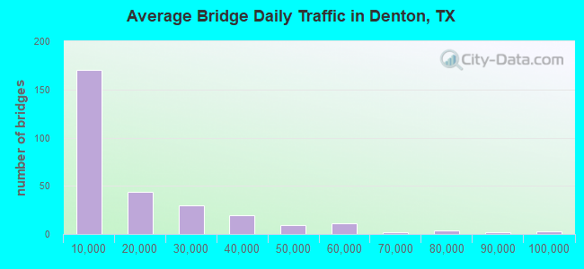
- 4,491,088Total average daily traffic
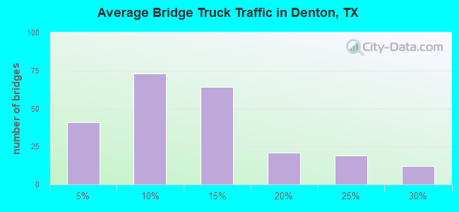
- 543,508Total average daily truck traffic
- National Bridge Inventory (NBI) Registered Bridges for Denton
- No street view available for this location
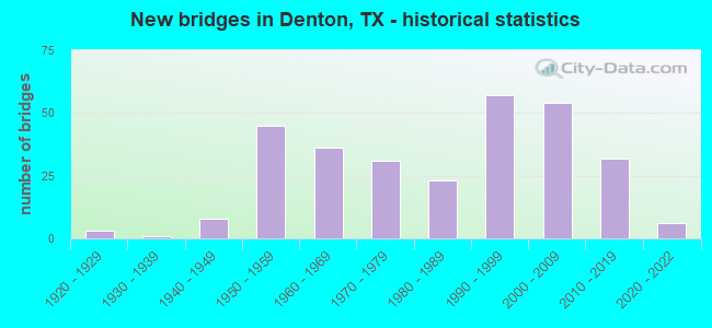
- New bridges - historical statistics
- 31920-1929
- 11930-1939
- 81940-1949
- 451950-1959
- 361960-1969
- 311970-1979
- 231980-1989
- 571990-1999
- 542000-2009
- 322010-2019
- 62020-2022
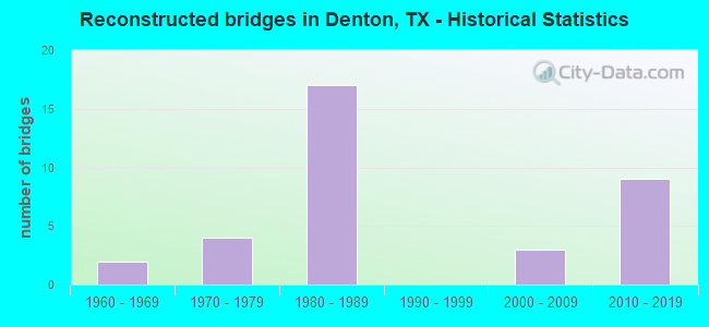
- Reconstructed bridges - Historical Statistics
- 21960-1969
- 41970-1979
- 171980-1989
- 01990-1999
- 32000-2009
- 92010-2019
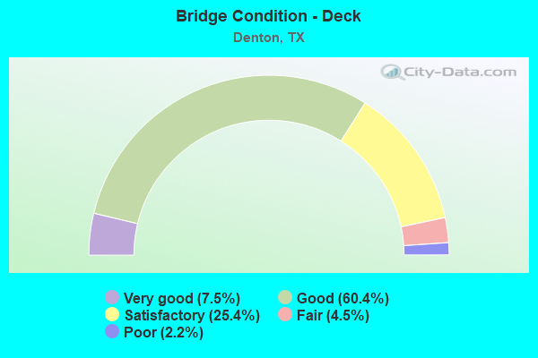
- Bridge Condition - Deck
- 7.5%Very good
- 60.4%Good
- 25.4%Satisfactory
- 4.5%Fair
- 2.2%Poor
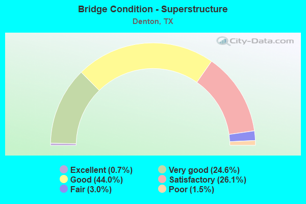
- Bridge Condition - Superstructure
- 0.7%Excellent
- 24.6%Very good
- 44.0%Good
- 26.1%Satisfactory
- 3.0%Fair
- 1.5%Poor
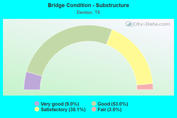
- Bridge Condition - Substructure
- 9.0%Very good
- 53.0%Good
- 35.1%Satisfactory
- 3.0%Fair
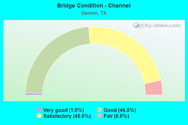
- Bridge Condition - Channel
- 1.0%Very good
- 46.5%Good
- 45.5%Satisfactory
- 6.9%Fair
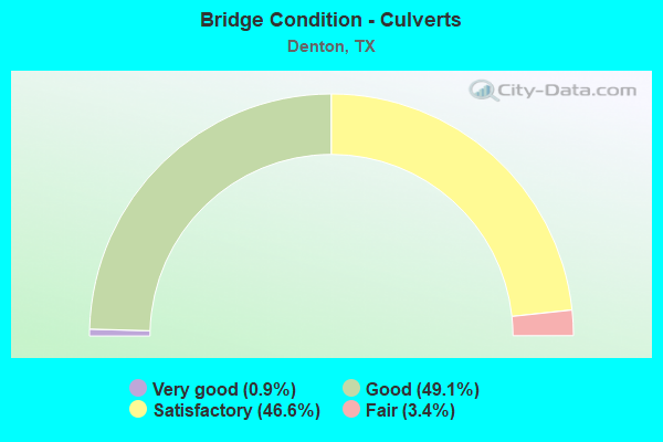
- Bridge Condition - Culverts
- 0.9%Very good
- 49.1%Good
- 46.6%Satisfactory
- 3.4%Fair
Find on map >> Show street view
Structure Number: 180610008113091, Location: 1.40 MI S OF FM 1515 (Lat: 33.185733, Lng: -97.172844), Route carried "under" structure: City street , Year Built: 1969, Structure Length: 0. m, Average Daily Traffic: 1,000 (year 2016), Truck Traffic: 5%, Features Intersected: None, Facility Carried by Structure: IH 35W SBML
Minimum Vertical Clearance: 4.80m (15.75ft), Kilometerpoint: 1.754, Material/Design: Concrete, Design/Construction: Stringer/Multi-beam, Length of Maximum Span: 12.5m (41.0ft)
Find on map >> Show street view
Structure Number: 180610008113092, Location: 1.40 MI S OF FM 1515 (Lat: 33.185897, Lng: -97.172489), Route carried "under" structure: City street , Year Built: 1969, Structure Length: 0. m, Average Daily Traffic: 1,000 (year 2016), Truck Traffic: 5%, Features Intersected: None, Facility Carried by Structure: IH 35W NBML
Minimum Vertical Clearance: 4.55m (14.93ft), Kilometerpoint: 1.770, Material/Design: Concrete, Design/Construction: Stringer/Multi-beam, Length of Maximum Span: 12.5m (41.0ft)
Find on map >> Show street view
Structure Number: 180610008113099, Location: 2.90 MI S OF IH 35E (Lat: 33.171744, Lng: -97.181264), Route carried "under" structure: Interstate 35, Year Built: 1969, Structure Length: 0. m, Average Daily Traffic: 43,890 (year 2013), Truck Traffic: 7%, Features Intersected: IH 35W, Facility Carried by Structure: FM 2449
Minimum Vertical Clearance: 5.11m (16.77ft), Kilometerpoint: 23.316, Lanes on structure: 2, Lanes under structure: 5, Material/Design: Prestressed concrete, Design/Construction: Stringer/Multi-beam, Length of Maximum Span: 24.4m (80.1ft)
Find on map >> Show street view
Structure Number: 180610008113102, Location: 1.50 MI S OF FM 2449 (Lat: 33.153792, Lng: -97.192111), Route carried "under" structure: Interstate 35, Year Built: 1969, Structure Length: 0. m, Average Daily Traffic: 40,070 (year 2013), Truck Traffic: 14%, Features Intersected: IH 35W, Facility Carried by Structure: JOHN PAINE ROAD
Minimum Vertical Clearance: 5.39m (17.68ft), Kilometerpoint: 21.089, Lanes on structure: 2, Lanes under structure: 4, Material/Design: Prestressed concrete, Design/Construction: Stringer/Multi-beam, Length of Maximum Span: 25.9m (85.0ft)
Find on map >> Show street view
Structure Number: 180610008113135, Location: 0.40 MI S OF IH 35 (Lat: 33.205614, Lng: -97.163956), Route carried "under" structure: Interstate 35, Year Built: 1970, Structure Length: 0. m, Average Daily Traffic: 43,890 (year 2013), Truck Traffic: 7%, Features Intersected: None, Facility Carried by Structure: FM 1515
Minimum Vertical Clearance: 6.02m (19.75ft), Kilometerpoint: 27.420, Lanes on structure: 2, Lanes under structure: 6, Material/Design: Prestressed concrete, Design/Construction: Stringer/Multi-beam, Length of Maximum Span: 24.4m (80.1ft)
Find on map >> Show street view
Structure Number: 180610008113136, Location: 1.60 MI NW OF US 377 (Lat: 33.208278, Lng: -97.161444), Route carried "under" structure: State highway 1515, Year Built: 1970, Structure Length: 0. m, Average Daily Traffic: 12,500 (year 2013), Truck Traffic: 14%, Features Intersected: FM 1515, Facility Carried by Structure: IH 35W NB CONN A
Minimum Vertical Clearance: 5.03m (16.50ft), Kilometerpoint: 3.277, Lanes on structure: 1, Lanes under structure: 4, Material/Design: Prestressed concrete, Design/Construction: Stringer/Multi-beam, Length of Maximum Span: 18.3m (60.0ft)
Find on map >> Show street view
Structure Number: 180610008113143, Location: 2.30 MI NW OF US 377 (Lat: 33.215550, Lng: -97.168586), Route carried "under" structure: City street , Year Built: 1970, Structure Length: 0. m, Average Daily Traffic: 1,000 (year 2011), Truck Traffic: 5%, Features Intersected: None, Facility Carried by Structure: IH 35W NBML
Minimum Vertical Clearance: 5.13m (16.83ft), Kilometerpoint: 0.885, Material/Design: Prestressed concrete, Design/Construction: Stringer/Multi-beam, Length of Maximum Span: 24.4m (80.1ft)
Find on map >> Show street view
Structure Number: 180610013409002, Location: 4.35 MI W OF IH35 (Lat: 33.234936, Lng: -97.248592), Route carried "under" structure: State highway 156, Year Built: 2006, Structure Length: 0. m, Average Daily Traffic: 4,500 (year 2009), Truck Traffic: 11%, Features Intersected: None, Facility Carried by Structure: US 380
Minimum Vertical Clearance: 6.07m (19.91ft), Kilometerpoint: 12.505, Material/Design: Prestressed concrete, Design/Construction: Stringer/Multi-beam, Length of Maximum Span: 34.7m (113.8ft)
Find on map >> Show street view
Structure Number: 180610013510096, Location: 2.15 MI SE OF FM 426 (Lat: 33.233789, Lng: -97.089700), Route carried "under" structure: US 377, Year Built: 1987, Structure Length: 0. m, Average Daily Traffic: 21,060 (year 2013), Truck Traffic: 9%, Features Intersected: US380 / UPRR / MINGO RD, Facility Carried by Structure: LP 288 NB
Minimum Vertical Clearance: 5.69m (18.67ft), Kilometerpoint: 7.242, Lanes on structure: 2, Lanes under structure: 12, Material/Design: Prestressed concrete, Design/Construction: Stringer/Multi-beam, Length of Maximum Span: 29.9m (98.1ft)
Find on map >> Show street view
Structure Number: 180610013510097, Location: 2.15 MI SE OF FM 426 (Lat: 33.233414, Lng: -97.089936), Route carried "under" structure: US 377, Year Built: 1987, Structure Length: 0. m, Average Daily Traffic: 21,060 (year 2013), Truck Traffic: 9%, Features Intersected: US380 / UPRR / MINGO RD, Facility Carried by Structure: LP 288 SB
Minimum Vertical Clearance: 5.79m (19.00ft), Kilometerpoint: 7.265, Lanes on structure: 2, Lanes under structure: 12, Material/Design: Prestressed concrete, Design/Construction: Stringer/Multi-beam, Length of Maximum Span: 29.9m (98.1ft)
Find on map >> Show street view
Structure Number: 180610013510226, Location: 0.40 MI W OF LP 288 (Lat: 33.234494, Lng: -97.096933), Route carried "under" structure: City street , Year Built: 2006, Structure Length: 0. m, Average Daily Traffic: 2,000 (year 2013), Truck Traffic: 1%, Features Intersected: None, Facility Carried by Structure: US 380 WB
Minimum Vertical Clearance: 7.62m (25.00ft), Kilometerpoint: 27.434, Material/Design: Prestressed concrete, Design/Construction: Stringer/Multi-beam, Length of Maximum Span: 30.5m (100.1ft)
Find on map >> Show street view
Structure Number: 180610013510227, Location: 0.40 MI W OF LP 288 (Lat: 33.234367, Lng: -97.097117), Route carried "under" structure: City street , Year Built: 2006, Structure Length: 0. m, Average Daily Traffic: 2,000 (year 2013), Truck Traffic: 1%, Features Intersected: None, Facility Carried by Structure: US 380 EB
Minimum Vertical Clearance: 7.62m (25.00ft), Kilometerpoint: 27.434, Material/Design: Prestressed concrete, Design/Construction: Stringer/Multi-beam, Length of Maximum Span: 30.5m (100.1ft)
Find on map >> Show street view
Structure Number: 180610019502057, Location: 2.90 MI S OF FM 455 (Lat: 33.324547, Lng: -97.180553), Route carried "under" structure: Interstate 35, Year Built: 1958, Structure Length: 0. m, Average Daily Traffic: 52,630 (year 2013), Truck Traffic: 26%, Features Intersected: None, Facility Carried by Structure: RECTOR RD
Minimum Vertical Clearance: 5.46m (17.91ft), Kilometerpoint: 6.758, Material/Design: Steel continuous, Design/Construction: Stringer/Multi-beam, Length of Maximum Span: 19.8m (65.0ft)
Find on map >> Show street view
Structure Number: 180610019502065, Location: 4.70 MI N OF US 380 (Lat: 33.298853, Lng: -97.177797), Route carried "under" structure: Interstate 35, Year Built: 1958, Structure Length: 0. m, Average Daily Traffic: 53,620 (year 2013), Truck Traffic: 26%, Features Intersected: None, Facility Carried by Structure: FM 3163 (MILAM)
Minimum Vertical Clearance: 5.26m (17.26ft), Kilometerpoint: 5.493, Lanes on structure: 2, Lanes under structure: 6, Material/Design: Steel continuous, Design/Construction: Stringer/Multi-beam, Length of Maximum Span: 19.8m (65.0ft)
Find on map >> Show street view
Structure Number: 180610019502066, Location: 3.65 MI N OF US 380 (Lat: 33.283286, Lng: -97.178097), Route carried "under" structure: Interstate 35, Year Built: 1958, Structure Length: 0. m, Average Daily Traffic: 54,860 (year 2013), Truck Traffic: 16%, Features Intersected: None, Facility Carried by Structure: GANZER RD
Minimum Vertical Clearance: 5.31m (17.42ft), Kilometerpoint: 2.157, Lanes on structure: 2, Lanes under structure: 8, Material/Design: Steel continuous, Design/Construction: Stringer/Multi-beam, Length of Maximum Span: 19.8m (65.0ft)
Find on map >> Show street view
Structure Number: 180610019502073, Location: 5.80 MI N OF US 380 (Lat: 33.314964, Lng: -97.179483), Route carried "under" structure: State highway 156, Year Built: 1958, Structure Length: 0. m, Average Daily Traffic: 2,000 (year 2016), Truck Traffic: 10%, Features Intersected: None, Facility Carried by Structure: IH 35 NB
Minimum Vertical Clearance: 7.24m (23.75ft), Kilometerpoint: 0.016, Material/Design: Steel continuous, Design/Construction: Stringer/Multi-beam, Length of Maximum Span: 21.3m (69.9ft)
Find on map >> Show street view
Structure Number: 180610019502074, Location: 5.80 MI N OF US 380 (Lat: 33.314658, Lng: -97.179653), Route carried "under" structure: State highway 156, Year Built: 1958, Structure Length: 0. m, Average Daily Traffic: 2,000 (year 2016), Truck Traffic: 10%, Features Intersected: None, Facility Carried by Structure: IH 35 SB
Minimum Vertical Clearance: 7.09m (23.26ft), Kilometerpoint: 0.032, Material/Design: Steel continuous, Design/Construction: Stringer/Multi-beam, Length of Maximum Span: 21.3m (69.9ft)
Find on map >> Show street view
Structure Number: 180610019502135, Location: 0.70 MI E OF IH 35 (Lat: 33.257283, Lng: -97.165364), Route carried "under" structure: US 77, Year Built: 1992, Structure Length: 0. m, Average Daily Traffic: 3,250 (year 2010), Truck Traffic: 4%, Features Intersected: None, Facility Carried by Structure: LP 288 WB
Minimum Vertical Clearance: 5.18m (16.99ft), Kilometerpoint: 32.617, Lanes on structure: 5, Material/Design: Prestressed concrete, Design/Construction: Stringer/Multi-beam, Length of Maximum Span: 21.3m (69.9ft)
Find on map >> Show street view
Structure Number: 180610019502136, Location: 0.70 MI E OF IH 35 (Lat: 33.257289, Lng: -97.164650), Route carried "under" structure: US 77, Year Built: 1992, Structure Length: 0. m, Average Daily Traffic: 10,470 (year 2013), Truck Traffic: 19%, Features Intersected: None, Facility Carried by Structure: LP 288 EB
Minimum Vertical Clearance: 5.26m (17.26ft), Kilometerpoint: 33.698, Lanes on structure: 2, Lanes under structure: 5, Material/Design: Prestressed concrete, Design/Construction: Stringer/Multi-beam, Length of Maximum Span: 21.3m (69.9ft)
Find on map >> Show street view
Structure Number: 18061001950304, Location: 2.30 MI N OF US 380 (Lat: 33.263647, Lng: -97.177844), Route carried "under" structure: US 77, Year Built: 1958, Structure Length: 0. m, Average Daily Traffic: 10,470 (year 2013), Truck Traffic: 19%, Features Intersected: US 77 SB & CONN, Facility Carried by Structure: IH 35
Minimum Vertical Clearance: 4.70m (15.42ft), Kilometerpoint: 32.280, Lanes on structure: 4, Lanes under structure: 3, Material/Design: Steel continuous, Design/Construction: Stringer/Multi-beam, Length of Maximum Span: 13.7m (44.9ft)
Find on map >> Show street view
Structure Number: 18061001950309, Location: 1.45 MI SE OF US 377 (Lat: 33.191839, Lng: -97.115178), Route carried "under" structure: US 77, Year Built: 1958, Structure Length: 0. m, Average Daily Traffic: 9,800 (year 2010), Truck Traffic: 2%, Features Intersected: US 77 SB, Facility Carried by Structure: IH 35E NBML
Minimum Vertical Clearance: 4.65m (15.26ft), Kilometerpoint: 43.404, Material/Design: Steel continuous, Design/Construction: Stringer/Multi-beam, Length of Maximum Span: 25.9m (85.0ft)
Find on map >> Show street view
Structure Number: 180610019503118, Location: 1.60 MI NW OF US 377 (Lat: 33.208908, Lng: -97.161381), Route carried "under" structure: State highway 1515, Year Built: 1970, Structure Length: 0. m, Average Daily Traffic: 12,500 (year 2013), Truck Traffic: 14%, Features Intersected: FM 1515, Facility Carried by Structure: IH 35E NB CONN B
Minimum Vertical Clearance: 4.83m (15.85ft), Kilometerpoint: 3.347, Lanes on structure: 1, Lanes under structure: 4, Material/Design: Prestressed concrete, Design/Construction: Stringer/Multi-beam, Length of Maximum Span: 24.4m (80.1ft)
Find on map >> Show street view
Structure Number: 180610019503133, Location: 1.75 MI N OF US 380 (Lat: 33.255742, Lng: -97.177597), Route carried "under" structure: Interstate 35, Year Built: 1992, Structure Length: 0. m, Average Daily Traffic: 52,260 (year 2013), Truck Traffic: 12%, Features Intersected: None, Facility Carried by Structure: LP 288 WB
Minimum Vertical Clearance: 5.39m (17.68ft), Kilometerpoint: 26.804, Material/Design: Prestressed concrete, Design/Construction: Stringer/Multi-beam, Length of Maximum Span: 30.5m (100.1ft)
Find on map >> Show street view
Structure Number: 180610019503134, Location: 1.75 MI N OF US 380 (Lat: 33.255569, Lng: -97.177583), Route carried "under" structure: Interstate 35, Year Built: 1992, Structure Length: 0. m, Average Daily Traffic: 52,260 (year 2013), Truck Traffic: 12%, Features Intersected: None, Facility Carried by Structure: LP 288 EB
Minimum Vertical Clearance: 5.16m (16.93ft), Kilometerpoint: 26.781, Lanes on structure: 2, Lanes under structure: 8, Material/Design: Prestressed concrete, Design/Construction: Stringer/Multi-beam, Length of Maximum Span: 30.5m (100.1ft)
Find on map >> Show street view
Structure Number: 180610019503137, Location: 0.90 MI SE OF US 377 (Lat: 33.193425, Lng: -97.124197), Route carried "under" structure: Alternate State highway 2181, Year Built: 1995, Structure Length: 0. m, Average Daily Traffic: 19,540 (year 2013), Truck Traffic: 2%, Features Intersected: None, Facility Carried by Structure: IH 35E
Minimum Vertical Clearance: 5.13m (16.83ft), Kilometerpoint: 0.547, Material/Design: Prestressed concrete, Design/Construction: Stringer/Multi-beam, Length of Maximum Span: 25.9m (85.0ft)
Find on map >> Show street view
Structure Number: 180610019503139, Location: 1.80 MI NW OF US 377 (Lat: 33.209739, Lng: -97.165014), Route carried "under" structure: Interstate 35, Year Built: 1970, Structure Length: 0. m, Average Daily Traffic: 58,640 (year 2013), Truck Traffic: 12%, Features Intersected: None
Minimum Vertical Clearance: 5.05m (16.57ft), Kilometerpoint: 21.461, Material/Design: Steel continuous, Design/Construction: Stringer/Multi-beam, Length of Maximum Span: 27.4m (89.9ft)
Find on map >> Show street view
Structure Number: 18061001950314, Location: 1.90 MI NW OF US 377 (Lat: 33.210853, Lng: -97.165453), Route carried "under" structure: Interstate 35, Year Built: 1970, Structure Length: 0. m, Average Daily Traffic: 13,000 (year 2013), Truck Traffic: 16%, Features Intersected: None
Minimum Vertical Clearance: 5.82m (19.09ft), Kilometerpoint: 27.826, Material/Design: Steel continuous, Design/Construction: Stringer/Multi-beam, Length of Maximum Span: 33.5m (109.9ft)
Find on map >> Show street view
Structure Number: 180610019503141, Location: 1.90 MI NW OF US 377 (Lat: 33.210772, Lng: -97.164986), Route carried "under" structure: Interstate 35, Year Built: 1970, Structure Length: 0. m, Average Daily Traffic: 13,000 (year 2013), Truck Traffic: 16%, Features Intersected: None
Minimum Vertical Clearance: 5.08m (16.67ft), Kilometerpoint: 27.826, Material/Design: Steel continuous, Design/Construction: Stringer/Multi-beam, Length of Maximum Span: 33.5m (109.9ft)
Find on map >> Show street view
Structure Number: 180610019503149, Location: 1.10 MI S OF US 380 (Lat: 33.215153, Lng: -97.168753), Route carried "under" structure: City street , Year Built: 2004, Structure Length: 0. m, Average Daily Traffic: 1,000 (year 2013), Truck Traffic: 5%, Features Intersected: None, Facility Carried by Structure: IH 35
Minimum Vertical Clearance: 5.28m (17.32ft), Kilometerpoint: 0.853, Material/Design: Prestressed concrete, Design/Construction: Box Beam or Girders - Multiple, Length of Maximum Span: 21.3m (69.9ft)
Find on map >> Show street view
Structure Number: 180610019503201, Location: 2.50 MI S OF US 380 (Lat: 33.196286, Lng: -97.138900), Route carried "under" structure: US 377, Year Built: 2004, Structure Length: 0. m, Average Daily Traffic: 18,540 (year 2013), Truck Traffic: 19%, Features Intersected: None, Facility Carried by Structure: IH 35E NB
Minimum Vertical Clearance: 5.36m (17.59ft), Kilometerpoint: 4.432, Lanes on structure: 2, Lanes under structure: 7, Material/Design: Prestressed concrete, Design/Construction: Box Beam or Girders - Multiple, Length of Maximum Span: 34.1m (111.9ft)
Find on map >> Show street view
Structure Number: 180610019503206, Location: 1.50 MI N OF IH 35W (Lat: 33.229575, Lng: -97.173614), Route carried "under" structure: US 380, Year Built: 2005, Structure Length: 0. m, Average Daily Traffic: 17,900 (year 2013), Truck Traffic: 17%, Features Intersected: None, Facility Carried by Structure: IH 35 NBML
Minimum Vertical Clearance: 5.18m (16.99ft), Kilometerpoint: 20.279, Material/Design: Steel, Design/Construction: Stringer/Multi-beam, Length of Maximum Span: 24.4m (80.1ft)
Find on map >> Show street view
Structure Number: 180610019503207, Location: 1.50 MI N OF IH 35W (Lat: 33.229603, Lng: -97.173914), Route carried "under" structure: US 380, Year Built: 2005, Structure Length: 0. m, Average Daily Traffic: 21,240 (year 2013), Truck Traffic: 17%, Features Intersected: None, Facility Carried by Structure: IH 35 SBML
Minimum Vertical Clearance: 5.18m (16.99ft), Kilometerpoint: 20.276, Material/Design: Steel, Design/Construction: Stringer/Multi-beam, Length of Maximum Span: 24.4m (80.1ft)
Find on map >> Show street view
Structure Number: 180610019503209, Location: 1.60 MI NW of US 377 (Lat: 33.208517, Lng: -97.161283), Route carried "under" structure: State highway 1515, Year Built: 1958, Structure Length: 0. m, Average Daily Traffic: 9,300 (year 2011), Truck Traffic: 1%, Features Intersected: FM 1515, Facility Carried by Structure: IH 35E ML
Minimum Vertical Clearance: 4.75m (15.58ft), Kilometerpoint: 3.317, Lanes on structure: 6, Lanes under structure: 4, Material/Design: Steel continuous, Design/Construction: Stringer/Multi-beam, Length of Maximum Span: 18.3m (60.0ft)
Find on map >> Show street view
Structure Number: 18061001950321, Location: 1.05 MI NW OF US 377 (Lat: 33.204519, Lng: -97.152881), Route carried "under" structure: Interstate 35, Year Built: 2016, Structure Length: 0. m, Average Daily Traffic: 81,000 (year 2016), Truck Traffic: 10%, Features Intersected: IH 35E, Facility Carried by Structure: NORTH TEXAS BLVD
Minimum Vertical Clearance: 4.42m (14.50ft), Kilometerpoint: 20.117, Lanes on structure: 8, Lanes under structure: 6, Material/Design: Prestressed concrete, Design/Construction: Stringer/Multi-beam, Length of Maximum Span: 31.1m (102.0ft)
Find on map >> Show street view
Structure Number: 180610019503211, Location: 1.05 MI NW OF US 377 (Lat: 33.204831, Lng: -97.153039), Route carried "under" structure: City street 35, Year Built: 2016, Structure Length: 0. m, Average Daily Traffic: 81,000 (year 2016), Truck Traffic: 10%, Features Intersected: McCORMICK ST
Minimum Vertical Clearance: 5.03m (16.50ft), Kilometerpoint: 20.117, Lanes on structure: 6, Lanes under structure: 2, Material/Design: Prestressed concrete, Design/Construction: Stringer/Multi-beam, Length of Maximum Span: 28.7m (94.2ft)
Structure Number: 180610019503214, Location: 2.5 MI S OF US 380, Route carried "under" structure: US 377, Year Built: 2004, Structure Length: 0. m, Average Daily Traffic: 18,540 (year 2013), Truck Traffic: 19%, Features Intersected: None, Facility Carried by Structure: IH 35E SB
Minimum Vertical Clearance: 6.89m (22.60ft), Kilometerpoint: 4.432, Lanes on structure: 2, Lanes under structure: 7, Material/Design: Prestressed concrete, Design/Construction: Box Beam or Girders - Multiple, Length of Maximum Span: 34.1m (111.9ft)
Minimum Vertical Clearance: 6.89m (22.60ft), Kilometerpoint: 4.432, Lanes on structure: 2, Lanes under structure: 7, Material/Design: Prestressed concrete, Design/Construction: Box Beam or Girders - Multiple, Length of Maximum Span: 34.1m (111.9ft)
Find on map >> Show street view
Structure Number: 180610019601468, Location: 4.20 MI NW OF FM 2181 (Lat: 33.173622, Lng: -97.089931), Route carried "under" structure: City street , Year Built: 1960, Structure Length: 0. m, Average Daily Traffic: 14,000 (year 2016), Truck Traffic: 3%, Features Intersected: MAYHILL RD, Facility Carried by Structure: IH 35E ML
Minimum Vertical Clearance: 4.57m (14.99ft), Kilometerpoint: 0.161, Lanes on structure: 8, Lanes under structure: 5, Material/Design: Prestressed concrete, Design/Construction: Stringer/Multi-beam, Length of Maximum Span: 16.8m (55.1ft)
Find on map >> Show street view
Structure Number: 180610019601498, Location: 4.20 MI NW OF FM 2181 (Lat: 33.173622, Lng: -97.089931), Route carried "under" structure: City street , Year Built: 2017, Structure Length: 0. m, Average Daily Traffic: 14,000 (year 2016), Truck Traffic: 3%, Features Intersected: None, Facility Carried by Structure: IH-35E SB
Minimum Vertical Clearance: 4.57m (14.99ft), Kilometerpoint: 26.081, Lanes on structure: 2, Material/Design: Prestressed concrete, Design/Construction: Stringer/Multi-beam, Length of Maximum Span: 41.3m (135.5ft)
Find on map >> Show street view
Structure Number: 180610019601525, Location: 0.6 MI SE OF LOOP 288 (Lat: 33.181267, Lng: -97.100789), Route carried "under" structure: City street , Year Built: 2019, Structure Length: 0. m, Average Daily Traffic: 13,524 (year 2015), Truck Traffic: 3%, Features Intersected: BRINKER RD, Facility Carried by Structure: IH 35E
Minimum Vertical Clearance: 6.31m (20.70ft), Kilometerpoint: 0.000, Lanes on structure: 6, Lanes under structure: 8, Material/Design: Prestressed concrete, Design/Construction: Stringer/Multi-beam, Length of Maximum Span: 36.6m (120.1ft)
Find on map >> Show street view
Structure Number: 180610019601526, Location: 0.6 MI SE OF US 77 (Lat: 33.186625, Lng: -97.107706), Route carried "under" structure: State highway 288, Year Built: 2019, Structure Length: 0. m, Average Daily Traffic: 29,915 (year 2017), Truck Traffic: 20%, Features Intersected: Loop 288, Facility Carried by Structure: IH 35E
Minimum Vertical Clearance: 8.93m (29.30ft), Kilometerpoint: 0.000, Lanes on structure: 6, Lanes under structure: 10, Material/Design: Prestressed concrete, Design/Construction: Stringer/Multi-beam, Length of Maximum Span: 36.3m (119.1ft)
Find on map >> Show street view
Structure Number: 180610225002009, Location: 0.90 MI E OF IH 35 (Lat: 33.258142, Lng: -97.161447), Route carried "under" structure: City street , Year Built: 1992, Structure Length: 0. m, Average Daily Traffic: 200 (year 2009), Features Intersected: None, Facility Carried by Structure: LP 288 WB
Minimum Vertical Clearance: 6.20m (20.34ft), Kilometerpoint: 0.805, Lanes on structure: 3, Lanes under structure: 2, Material/Design: Prestressed concrete, Design/Construction: Stringer/Multi-beam, Length of Maximum Span: 27.7m (90.9ft)
Find on map >> Show street view
Structure Number: 18061022500201, Location: 0.90 MI E OF IH 35 (Lat: 33.257850, Lng: -97.161456), Route carried "under" structure: City street , Year Built: 1992, Structure Length: 0. m, Average Daily Traffic: 200 (year 2009), Features Intersected: None, Facility Carried by Structure: LP 288 EB
Minimum Vertical Clearance: 5.33m (17.49ft), Kilometerpoint: 0.805, Lanes on structure: 2, Material/Design: Prestressed concrete, Design/Construction: Stringer/Multi-beam, Length of Maximum Span: 27.7m (90.9ft)
Find on map >> Show street view
Structure Number: 180610225002013, Location: 2.70 MI E OF IH 35 (Lat: 33.260733, Lng: -97.131497), Route carried "under" structure: State highway 2164, Year Built: 1992, Structure Length: 0. m, Average Daily Traffic: 5,820 (year 2013), Truck Traffic: 14%, Features Intersected: None, Facility Carried by Structure: LP 288 WB
Minimum Vertical Clearance: 5.21m (17.09ft), Kilometerpoint: 13.438, Lanes on structure: 2, Lanes under structure: 2, Material/Design: Prestressed concrete, Design/Construction: Stringer/Multi-beam, Length of Maximum Span: 31.1m (102.0ft)
Find on map >> Show street view
Structure Number: 180610225002014, Location: 2.70 MI E OF IH 35 (Lat: 33.260536, Lng: -97.131503), Route carried "under" structure: State highway 2164, Year Built: 1992, Structure Length: 0. m, Average Daily Traffic: 5,820 (year 2013), Truck Traffic: 14%, Features Intersected: None, Facility Carried by Structure: LP 288 EB
Minimum Vertical Clearance: 5.36m (17.59ft), Kilometerpoint: 13.438, Lanes on structure: 2, Lanes under structure: 2, Material/Design: Prestressed concrete, Design/Construction: Stringer/Multi-beam, Length of Maximum Span: 31.1m (102.0ft)
Find on map >> Show street view
Structure Number: 180610225002164, Location: 4.00 MI E OF IH 35 (Lat: 33.257744, Lng: -97.109700), Route carried "under" structure: State highway 428, Year Built: 1987, Structure Length: 0. m, Average Daily Traffic: 7,640 (year 2016), Truck Traffic: 8%, Features Intersected: None, Facility Carried by Structure: LP 288 EB
Minimum Vertical Clearance: 5.05m (16.57ft), Kilometerpoint: 5.681, Lanes on structure: 2, Lanes under structure: 2, Material/Design: Prestressed concrete, Design/Construction: Stringer/Multi-beam, Length of Maximum Span: 29.0m (95.1ft)
Find on map >> Show street view
Structure Number: 180610225002165, Location: 4.00 MI E OF IH 35 (Lat: 33.258003, Lng: -97.109794), Route carried "under" structure: State highway 428, Year Built: 1987, Structure Length: 0. m, Average Daily Traffic: 7,640 (year 2016), Truck Traffic: 8%, Features Intersected: None, Facility Carried by Structure: LP 288 WB
Minimum Vertical Clearance: 5.33m (17.49ft), Kilometerpoint: 5.681, Lanes on structure: 2, Lanes under structure: 2, Material/Design: Prestressed concrete, Design/Construction: Stringer/Multi-beam, Length of Maximum Span: 29.0m (95.1ft)