Bridge Statistics for Denton, Texas (TX)
Condition, Traffic, Stress, Structural Evaluation, Project Costs
- National Bridge Inventory (NBI) Statistics
- 296Number of bridges
- 3,894ft / 1,187mTotal length
- $742,000Total costs
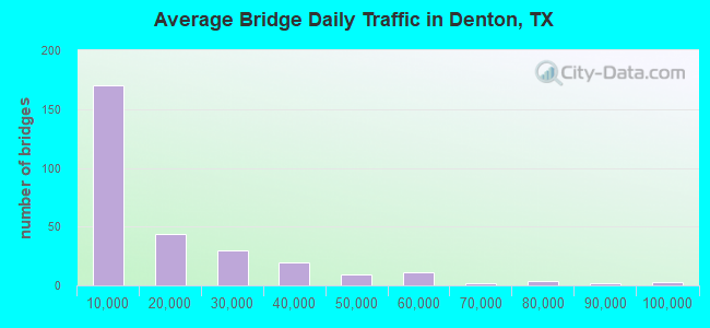
- 4,491,088Total average daily traffic
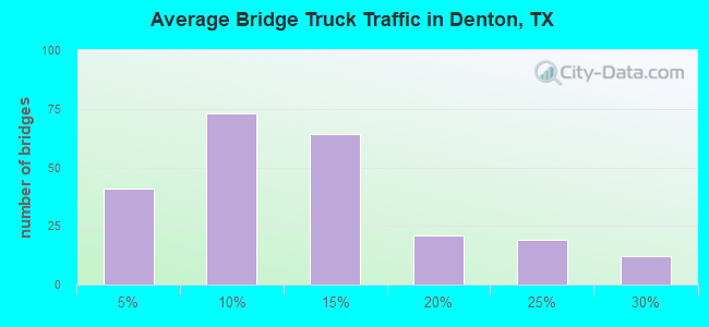
- 543,508Total average daily truck traffic
- National Bridge Inventory (NBI) Registered Bridges for Denton
- No street view available for this location
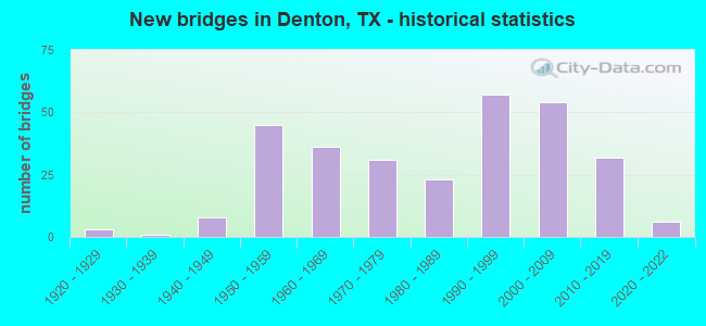
- New bridges - historical statistics
- 31920-1929
- 11930-1939
- 81940-1949
- 451950-1959
- 361960-1969
- 311970-1979
- 231980-1989
- 571990-1999
- 542000-2009
- 322010-2019
- 62020-2022
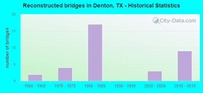
- Reconstructed bridges - Historical Statistics
- 21960-1969
- 41970-1979
- 171980-1989
- 01990-1999
- 32000-2009
- 92010-2019
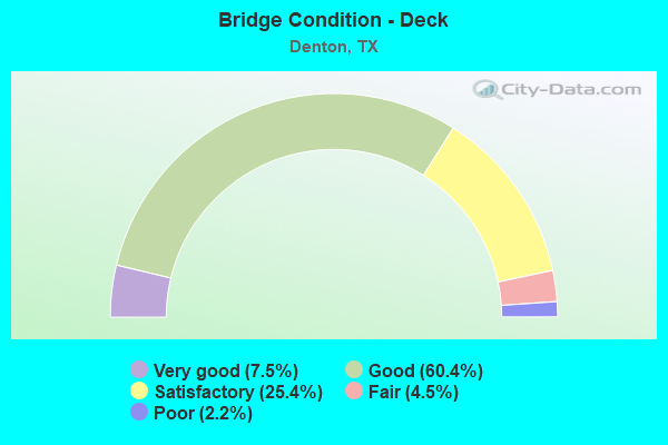
- Bridge Condition - Deck
- 7.5%Very good
- 60.4%Good
- 25.4%Satisfactory
- 4.5%Fair
- 2.2%Poor
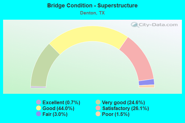
- Bridge Condition - Superstructure
- 0.7%Excellent
- 24.6%Very good
- 44.0%Good
- 26.1%Satisfactory
- 3.0%Fair
- 1.5%Poor
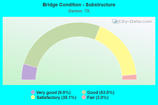
- Bridge Condition - Substructure
- 9.0%Very good
- 53.0%Good
- 35.1%Satisfactory
- 3.0%Fair
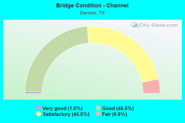
- Bridge Condition - Channel
- 1.0%Very good
- 46.5%Good
- 45.5%Satisfactory
- 6.9%Fair
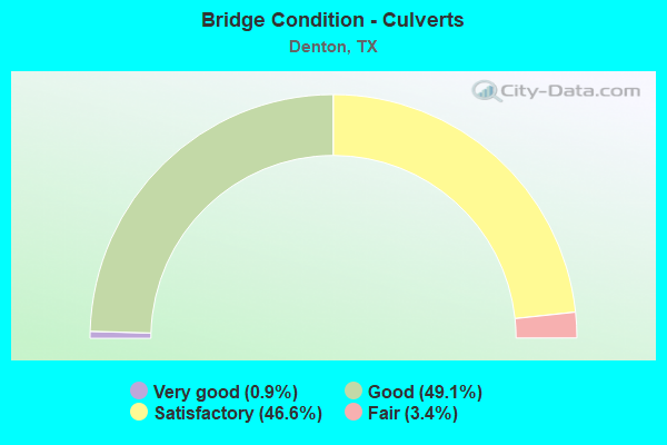
- Bridge Condition - Culverts
- 0.9%Very good
- 49.1%Good
- 46.6%Satisfactory
- 3.4%Fair
Find on map >> Show street view
Structure Number: 180610013409136, Location: 1.4 Mi W of IH 35 (Lat: 33.231081, Lng: -97.198894), Route carried "on" structure: US 380, Year Built: 2015, Status: Open, Structure Length: 2.32m (7.61ft), Average Daily Traffic: 24,041 (year 2020), Truck Traffic: 11%, Average Future Daily Traffic: 28,310 (year 2036), Design Load: HS 20, Features Intersected: Draw
Minimum Vertical Clearance: 30+ m (98+ ft), Kilometerpoint: 17.943, Lanes on structure: 4, Owner: State Highway Agency, Approaching Roadway Width: 38.1m (125.0ft), Skew: 30 degrees, Material/Design: Concrete, Design/Construction: Culvert, Number Of Spans In Main Unit: 7, Length of Maximum Span: 3.0m (9.8ft), Curb or Sidewalk Widths: Left: 1.5m (4.9ft), Right: 1.5m (4.9ft)
Condition: Channel: Good, Culverts: Good, Operating Rating: 54.4 metric tons, Method Used To Determine Operating Rating: Assigned rating based on Load Factor Design (LFD) reported in metric tons, Inventory Rating: 32.7 metric tons, Method Used To Determine Inventory Rating: Assigned rating based on Load Factor Design (LFD) reported in metric tons, Structural Evaluation: Better than present minimum criteria, Waterway Adequacy: Equal to present desirable criteria, Approach Roadway Alignment: Equal to present desirable criteria, Designated Inspection Frequency: Every 24 months, Inspection Date: September 2021
Find on map >> Show street view
Structure Number: 180610013409137, Location: 2.5 Mi W of IH 35 (Lat: 33.231797, Lng: -97.217581), Route carried "on" structure: US 380, Year Built: 2016, Status: Open, Structure Length: 5.94m (19.49ft), Average Daily Traffic: 19,200 (year 2012), Truck Traffic: 11%, Average Future Daily Traffic: 1 (year 1900), Design Load: HL 93, Features Intersected: Dry Fork Hickory Creek
Minimum Vertical Clearance: 30+ m (98+ ft), Kilometerpoint: 16.209, Lanes on structure: 3, Base Highway Network: Yes, Owner: State Highway Agency, Approaching Roadway Width: 11.6m (38.1ft), Skew: 30 degrees, Material/Design: Prestressed concrete, Design/Construction: Stringer/Multi-beam, Number Of Spans In Main Unit: 3, Length of Maximum Span: 19.5m (64.0ft), Curb or Sidewalk Widths: Left: 0.0m, Right: 2.7m (8.9ft), Curb-To-Curb Width: 11.6m (38.1ft), Out-to-Out Width: 18.9m (62.0ft)
Condition: Deck: Good, Superstructure: Good, Substructure: Good, Channel: Good, Operating Rating: 54.4 metric tons, Method Used To Determine Operating Rating: Assigned ratings based on Load and Resistance Factor Design (LRFD) reported in metric tons, Inventory Rating: 32.7 metric tons, Method Used To Determine Inventory Rating: Assigned ratings based on Load and Resistance Factor Design (LRFD) reported in metric tons, Structural Evaluation: Better than present minimum criteria, Deck Geometry: High priority of replacement, Waterway Adequacy: Superior to present desirable criteria, Approach Roadway Alignment: Equal to present desirable criteria, Designated Inspection Frequency: Every 24 months, Inspection Date: October 2021, Deck Structure Type: Concrete Precast Panels, Wearing Surface/Protective System: Deck Protection: Epoxy Coated Reinforcing
Find on map >> Show street view
Structure Number: 18061001340914, Location: 1.25 Mi E of IH 35 (Lat: 33.229308, Lng: -97.148894), Route carried "on" structure: US 380, Year Built: 2015, Status: Open, Structure Length: 1.89m (6.20ft), Average Daily Traffic: 30,647 (year 2020), Truck Traffic: 15%, Average Future Daily Traffic: 32,200 (year 2033), Design Load: HL 93, Features Intersected: PECAN CREEK
Minimum Vertical Clearance: 30+ m (98+ ft), Kilometerpoint: 22.603, Lanes on structure: 3, Owner: State Highway Agency, Approaching Roadway Width: 24.7m (81.0ft), Skew: 4 degrees, Material/Design: Concrete, Design/Construction: Culvert, Number Of Spans In Main Unit: 5, Length of Maximum Span: 2.4m (7.9ft)
Condition: Channel: Good, Culverts: Good, Operating Rating: 54.4 metric tons, Method Used To Determine Operating Rating: Assigned ratings based on Load and Resistance Factor Design (LRFD) reported in metric tons, Inventory Rating: 32.7 metric tons, Method Used To Determine Inventory Rating: Assigned ratings based on Load and Resistance Factor Design (LRFD) reported in metric tons, Structural Evaluation: Better than present minimum criteria, Waterway Adequacy: Equal to present desirable criteria, Approach Roadway Alignment: Equal to present desirable criteria, Designated Inspection Frequency: Every 24 months, Inspection Date: September 2021
Find on map >> Show street view
Structure Number: 180610013510096, Location: 2.15 MI SE OF FM 426 (Lat: 33.233789, Lng: -97.089700), Route carried "on" structure: State highway 288, Year Built: 1987, Status: Open, Structure Length: 44.14m (144.82ft), Average Daily Traffic: 10,200 (year 2013), Truck Traffic: 20%, Average Future Daily Traffic: 14,280 (year 2033), Design Load: HS 20, Features Intersected: US380 / UPRR / MINGO RD
Minimum Vertical Clearance: 30+ m (98+ ft), Kilometerpoint: 36.209, Lanes on structure: 2, Lanes under structure: 12, Owner: State Highway Agency, Approaching Roadway Width: 11.3m (37.1ft), Skew: 9 degrees, Material/Design: Prestressed concrete, Design/Construction: Stringer/Multi-beam, Number Of Spans In Main Unit: 14, Number Of Approach Spans: 2, Length of Maximum Span: 29.9m (98.1ft), Curb-To-Curb Width: 11.3m (37.1ft), Out-to-Out Width: 12.2m (40.0ft)
Condition: Deck: Good, Superstructure: Good, Substructure: Satisfactory, Channel: Satisfactory, Operating Rating: 54.4 metric tons, Method Used To Determine Operating Rating: Assigned rating based on Load Factor Design (LFD) reported in metric tons, Inventory Rating: 32.7 metric tons, Method Used To Determine Inventory Rating: Assigned rating based on Load Factor Design (LFD) reported in metric tons, Structural Evaluation: Equal to present minimum criteria, Deck Geometry: Equal to present minimum criteria, Underclear: Somewhat better than minimum adequacy, Waterway Adequacy: Superior to present desirable criteria, Approach Roadway Alignment: Equal to present desirable criteria, Designated Inspection Frequency: Every 24 months, Inspection Date: September 2021, Deck Structure Type: Concrete Precast Panels
Find on map >> Show street view
Structure Number: 180610013510097, Location: 2.15 MI SE OF FM 426 (Lat: 33.233414, Lng: -97.089936), Route carried "on" structure: State highway 288, Year Built: 1987, Status: Open, Structure Length: 44.14m (144.82ft), Average Daily Traffic: 10,200 (year 2013), Truck Traffic: 20%, Average Future Daily Traffic: 14,280 (year 2033), Design Load: HS 20, Features Intersected: US 380 / UPRR / MINGO RD
Minimum Vertical Clearance: 30+ m (98+ ft), Kilometerpoint: 36.209, Lanes on structure: 2, Lanes under structure: 12, Owner: State Highway Agency, Approaching Roadway Width: 11.3m (37.1ft), Skew: 9 degrees, Material/Design: Prestressed concrete, Design/Construction: Stringer/Multi-beam, Number Of Spans In Main Unit: 14, Number Of Approach Spans: 2, Length of Maximum Span: 29.9m (98.1ft), Curb-To-Curb Width: 11.3m (37.1ft), Out-to-Out Width: 12.2m (40.0ft)
Condition: Deck: Good, Superstructure: Good, Substructure: Satisfactory, Channel: Satisfactory, Operating Rating: 54.4 metric tons, Method Used To Determine Operating Rating: Assigned rating based on Load Factor Design (LFD) reported in metric tons, Inventory Rating: 32.7 metric tons, Method Used To Determine Inventory Rating: Assigned rating based on Load Factor Design (LFD) reported in metric tons, Structural Evaluation: Equal to present minimum criteria, Deck Geometry: Equal to present minimum criteria, Underclear: Somewhat better than minimum adequacy, Waterway Adequacy: Superior to present desirable criteria, Approach Roadway Alignment: Equal to present desirable criteria, Designated Inspection Frequency: Every 24 months, Inspection Date: September 2021, Deck Structure Type: Concrete Precast Panels
Find on map >> Show street view
Structure Number: 180610013510121, Location: 0.05 MI E OF LP 288 (Lat: 33.233197, Lng: -97.088044), Route carried "on" structure: US 377, Year Built: 1999, Status: Open, Structure Length: 3.75m (12.30ft), Average Daily Traffic: 33,649 (year 2020), Truck Traffic: 9%, Average Future Daily Traffic: 47,670 (year 2033), Features Intersected: COOPER CREEK
Minimum Vertical Clearance: 30+ m (98+ ft), Kilometerpoint: 7.091, Lanes on structure: 7, Owner: State Highway Agency, Approaching Roadway Width: 33.8m (110.9ft), Skew: 23 degrees, Material/Design: Concrete, Design/Construction: Culvert, Number Of Spans In Main Unit: 10, Length of Maximum Span: 3.0m (9.8ft)
Condition: Channel: Satisfactory, Culverts: Satisfactory, Operating Rating: 39.9 metric tons, Method Used To Determine Operating Rating: Load Factor (LF), Inventory Rating: 23.6 metric tons, Method Used To Determine Inventory Rating: Load Factor (LF), Structural Evaluation: Somewhat better than minimum adequacy, Waterway Adequacy: Equal to present minimum criteria, Approach Roadway Alignment: Equal to present desirable criteria, Designated Inspection Frequency: Every 48 months, Inspection Date: September 2021
Find on map >> Show street view
Structure Number: 180610013510122, Location: 0.70 MI E OF LP 288 (Lat: 33.234511, Lng: -97.077747), Route carried "on" structure: US 377, Year Built: 1999, Status: Open, Structure Length: 1.46m (4.79ft), Average Daily Traffic: 33,649 (year 2020), Truck Traffic: 9%, Average Future Daily Traffic: 47,670 (year 2033), Design Load: HS 20, Features Intersected: DRAIN
Minimum Vertical Clearance: 30+ m (98+ ft), Kilometerpoint: 7.091, Lanes on structure: 7, Owner: State Highway Agency, Approaching Roadway Width: 28.0m (91.9ft), Material/Design: Concrete, Design/Construction: Culvert, Number Of Spans In Main Unit: 5, Length of Maximum Span: 2.4m (7.9ft)
Condition: Channel: Good, Culverts: Good, Operating Rating: 44.4 metric tons, Method Used To Determine Operating Rating: No rating analysis performed, Inventory Rating: 32.7 metric tons, Method Used To Determine Inventory Rating: No rating analysis performed, Structural Evaluation: Better than present minimum criteria, Waterway Adequacy: Equal to present minimum criteria, Approach Roadway Alignment: Equal to present desirable criteria, Designated Inspection Frequency: Every 48 months, Inspection Date: October 2021
Find on map >> Show street view
Structure Number: 180610013510123, Location: 1.45 MI E OF LP 288 (Lat: 33.236122, Lng: -97.065389), Route carried "on" structure: US 377, Year Built: 1999, Status: Open, Structure Length: 1.80m (5.91ft), Average Daily Traffic: 33,649 (year 2020), Truck Traffic: 9%, Average Future Daily Traffic: 47,670 (year 2033), Design Load: HS 20, Features Intersected: TIMBER BRANCH
Minimum Vertical Clearance: 30+ m (98+ ft), Kilometerpoint: 4.937, Lanes on structure: 7, Owner: State Highway Agency, Approaching Roadway Width: 28.0m (91.9ft), Material/Design: Concrete, Design/Construction: Culvert, Number Of Spans In Main Unit: 6, Length of Maximum Span: 2.4m (7.9ft)
Condition: Channel: Good, Culverts: Good, Operating Rating: 44.4 metric tons, Method Used To Determine Operating Rating: No rating analysis performed, Inventory Rating: 32.7 metric tons, Method Used To Determine Inventory Rating: No rating analysis performed, Structural Evaluation: Better than present minimum criteria, Waterway Adequacy: Equal to present desirable criteria, Approach Roadway Alignment: Equal to present desirable criteria, Designated Inspection Frequency: Every 48 months, Inspection Date: October 2021
Find on map >> Show street view
Structure Number: 180610013510124, Location: 2.10 MI E OF LP 288 (Lat: 33.237872, Lng: -97.053167), Route carried "on" structure: US 377, Year Built: 1999, Status: Open, Structure Length: 0.64m (2.10ft), Average Daily Traffic: 36,434 (year 2020), Truck Traffic: 7%, Average Future Daily Traffic: 43,280 (year 2033), Features Intersected: THOMPSON CREEK
Minimum Vertical Clearance: 30+ m (98+ ft), Kilometerpoint: 3.787, Lanes on structure: 7, Owner: State Highway Agency, Approaching Roadway Width: 28.0m (91.9ft), Skew: 3 degrees, Material/Design: Concrete, Design/Construction: Culvert, Number Of Spans In Main Unit: 2, Length of Maximum Span: 2.7m (8.9ft)
Condition: Channel: Good, Culverts: Good, Operating Rating: 44.4 metric tons, Method Used To Determine Operating Rating: No rating analysis performed, Inventory Rating: 32.7 metric tons, Method Used To Determine Inventory Rating: No rating analysis performed, Structural Evaluation: Better than present minimum criteria, Waterway Adequacy: Superior to present desirable criteria, Approach Roadway Alignment: Equal to present desirable criteria, Designated Inspection Frequency: Every 48 months, Inspection Date: October 2021
Find on map >> Show street view
Structure Number: 180610013510125, Location: 2.70 MI E OF LP 288 (Lat: 33.238128, Lng: -97.044031), Route carried "on" structure: US 377, Year Built: 1999, Status: Open, Structure Length: 7.77m (25.49ft), Average Daily Traffic: 18,536 (year 2020), Truck Traffic: 7%, Average Future Daily Traffic: 43,280 (year 2033), Design Load: HS 20, Features Intersected: ELM FORK TRINITY RIVER
Minimum Vertical Clearance: 30+ m (98+ ft), Kilometerpoint: 1.611, Lanes on structure: 3, Owner: State Highway Agency, Approaching Roadway Width: 16.5m (54.1ft), Material/Design: Prestressed concrete, Design/Construction: Stringer/Multi-beam, Number Of Spans In Main Unit: 3, Length of Maximum Span: 27.4m (89.9ft), Curb-To-Curb Width: 16.5m (54.1ft), Out-to-Out Width: 16.8m (55.1ft)
Condition: Deck: Good, Superstructure: Good, Substructure: Good, Channel: Good, Operating Rating: 54.4 metric tons, Method Used To Determine Operating Rating: Assigned rating based on Load Factor Design (LFD) reported in metric tons, Inventory Rating: 32.7 metric tons, Method Used To Determine Inventory Rating: Assigned rating based on Load Factor Design (LFD) reported in metric tons, Structural Evaluation: Better than present minimum criteria, Deck Geometry: Better than present minimum criteria, Waterway Adequacy: Superior to present desirable criteria, Approach Roadway Alignment: Equal to present desirable criteria, Designated Inspection Frequency: Every 24 months, Inspection Date: September 2021, Deck Structure Type: Concrete Precast Panels
Find on map >> Show street view
Structure Number: 180610013510126, Location: 2.70 MI E OF LP 288 (Lat: 33.238397, Lng: -97.043594), Route carried "on" structure: US 377, Year Built: 1999, Status: Open, Structure Length: 7.77m (25.49ft), Average Daily Traffic: 17,898 (year 2020), Truck Traffic: 14%, Average Future Daily Traffic: 10,930 (year 2033), Design Load: HS 20, Features Intersected: ELM FORK TRINITY RIVER
Minimum Vertical Clearance: 30+ m (98+ ft), Kilometerpoint: 1.614, Lanes on structure: 3, Owner: State Highway Agency, Approaching Roadway Width: 16.5m (54.1ft), Material/Design: Prestressed concrete, Design/Construction: Stringer/Multi-beam, Number Of Spans In Main Unit: 3, Length of Maximum Span: 27.4m (89.9ft), Curb-To-Curb Width: 16.5m (54.1ft), Out-to-Out Width: 16.8m (55.1ft)
Condition: Deck: Good, Superstructure: Good, Substructure: Good, Channel: Satisfactory, Operating Rating: 54.4 metric tons, Method Used To Determine Operating Rating: Assigned rating based on Load Factor Design (LFD) reported in metric tons, Inventory Rating: 32.7 metric tons, Method Used To Determine Inventory Rating: Assigned rating based on Load Factor Design (LFD) reported in metric tons, Structural Evaluation: Better than present minimum criteria, Deck Geometry: Better than present minimum criteria, Waterway Adequacy: Superior to present desirable criteria, Approach Roadway Alignment: Equal to present desirable criteria, Designated Inspection Frequency: Every 24 months, Inspection Date: September 2021, Deck Structure Type: Concrete Precast Panels
Find on map >> Show street view
Structure Number: 180610013510127, Location: 3.10 MI E OF LP 288 (Lat: 33.237894, Lng: -97.036742), Route carried "on" structure: US 377, Year Built: 1999, Status: Open, Structure Length: 12.19m (39.99ft), Average Daily Traffic: 18,536 (year 2020), Truck Traffic: 7%, Average Future Daily Traffic: 43,280 (year 2033), Design Load: HS 20, Features Intersected: ELM FK TRINITY RIV REL 1
Minimum Vertical Clearance: 30+ m (98+ ft), Kilometerpoint: 2.185, Lanes on structure: 3, Owner: State Highway Agency, Approaching Roadway Width: 16.5m (54.1ft), Material/Design: Prestressed concrete, Design/Construction: Stringer/Multi-beam, Number Of Spans In Main Unit: 5, Length of Maximum Span: 24.4m (80.1ft), Curb-To-Curb Width: 16.5m (54.1ft), Out-to-Out Width: 16.8m (55.1ft)
Condition: Deck: Good, Superstructure: Good, Substructure: Good, Channel: Good, Operating Rating: 54.4 metric tons, Method Used To Determine Operating Rating: Assigned rating based on Load Factor Design (LFD) reported in metric tons, Inventory Rating: 32.7 metric tons, Method Used To Determine Inventory Rating: Assigned rating based on Load Factor Design (LFD) reported in metric tons, Structural Evaluation: Better than present minimum criteria, Deck Geometry: Better than present minimum criteria, Waterway Adequacy: Superior to present desirable criteria, Approach Roadway Alignment: Equal to present desirable criteria, Designated Inspection Frequency: Every 24 months, Inspection Date: September 2021, Deck Structure Type: Concrete Precast Panels
Find on map >> Show street view
Structure Number: 180610013510128, Location: 3.10 MI E OF LP 288 (Lat: 33.238175, Lng: -97.036792), Route carried "on" structure: US 377, Year Built: 1999, Status: Open, Structure Length: 12.19m (39.99ft), Average Daily Traffic: 17,898 (year 2020), Truck Traffic: 7%, Average Future Daily Traffic: 43,280 (year 2033), Design Load: HS 20, Features Intersected: ELM FK TRINITY RIV REL 1
Minimum Vertical Clearance: 30+ m (98+ ft), Kilometerpoint: 2.189, Lanes on structure: 3, Owner: State Highway Agency, Approaching Roadway Width: 16.5m (54.1ft), Material/Design: Prestressed concrete, Design/Construction: Stringer/Multi-beam, Number Of Spans In Main Unit: 5, Length of Maximum Span: 24.4m (80.1ft), Curb-To-Curb Width: 16.5m (54.1ft), Out-to-Out Width: 16.8m (55.1ft)
Condition: Deck: Good, Superstructure: Good, Substructure: Good, Channel: Good, Operating Rating: 54.4 metric tons, Method Used To Determine Operating Rating: Assigned rating based on Load Factor Design (LFD) reported in metric tons, Inventory Rating: 32.7 metric tons, Method Used To Determine Inventory Rating: Assigned rating based on Load Factor Design (LFD) reported in metric tons, Structural Evaluation: Better than present minimum criteria, Deck Geometry: Better than present minimum criteria, Waterway Adequacy: Superior to present desirable criteria, Approach Roadway Alignment: Equal to present desirable criteria, Designated Inspection Frequency: Every 24 months, Inspection Date: September 2021, Deck Structure Type: Concrete Precast Panels
Find on map >> Show street view
Structure Number: 180610013510129, Location: 4.00 MI E OF LP 288 (Lat: 33.237622, Lng: -97.028433), Route carried "on" structure: US 377, Year Built: 1999, Status: Open, Structure Length: 24.38m (79.99ft), Average Daily Traffic: 18,536 (year 2020), Truck Traffic: 7%, Average Future Daily Traffic: 43,280 (year 2033), Design Load: HS 20, Features Intersected: ELM FK TRINITY RIV REL 2
Minimum Vertical Clearance: 30+ m (98+ ft), Kilometerpoint: 1.485, Lanes on structure: 3, Owner: State Highway Agency, Approaching Roadway Width: 16.5m (54.1ft), Material/Design: Prestressed concrete, Design/Construction: Stringer/Multi-beam, Number Of Spans In Main Unit: 10, Length of Maximum Span: 24.4m (80.1ft), Curb-To-Curb Width: 16.5m (54.1ft), Out-to-Out Width: 16.8m (55.1ft)
Condition: Deck: Satisfactory, Superstructure: Good, Substructure: Good, Channel: Good, Operating Rating: 54.4 metric tons, Method Used To Determine Operating Rating: Assigned rating based on Load Factor Design (LFD) reported in metric tons, Inventory Rating: 32.7 metric tons, Method Used To Determine Inventory Rating: Assigned rating based on Load Factor Design (LFD) reported in metric tons, Structural Evaluation: Better than present minimum criteria, Deck Geometry: Better than present minimum criteria, Waterway Adequacy: Superior to present desirable criteria, Approach Roadway Alignment: Equal to present desirable criteria, Designated Inspection Frequency: Every 24 months, Inspection Date: September 2021, Deck Structure Type: Concrete Precast Panels
Find on map >> Show street view
Structure Number: 18061001351013, Location: 4.00 MI E OF LP 288 (Lat: 33.237933, Lng: -97.028647), Route carried "on" structure: US 377, Year Built: 1999, Status: Open, Structure Length: 24.38m (79.99ft), Average Daily Traffic: 17,898 (year 2020), Truck Traffic: 7%, Average Future Daily Traffic: 43,280 (year 2033), Design Load: HS 20, Features Intersected: ELM FK TRINITY RIV REL 2
Minimum Vertical Clearance: 30+ m (98+ ft), Kilometerpoint: 1.489, Lanes on structure: 3, Owner: State Highway Agency, Approaching Roadway Width: 16.5m (54.1ft), Material/Design: Prestressed concrete, Design/Construction: Stringer/Multi-beam, Number Of Spans In Main Unit: 10, Length of Maximum Span: 24.4m (80.1ft), Curb-To-Curb Width: 16.5m (54.1ft), Out-to-Out Width: 16.8m (55.1ft)
Condition: Deck: Good, Superstructure: Good, Substructure: Good, Channel: Satisfactory, Operating Rating: 54.4 metric tons, Method Used To Determine Operating Rating: Assigned rating based on Load Factor Design (LFD) reported in metric tons, Inventory Rating: 32.7 metric tons, Method Used To Determine Inventory Rating: Assigned rating based on Load Factor Design (LFD) reported in metric tons, Structural Evaluation: Better than present minimum criteria, Deck Geometry: Better than present minimum criteria, Waterway Adequacy: Superior to present desirable criteria, Approach Roadway Alignment: Equal to present desirable criteria, Designated Inspection Frequency: Every 24 months, Inspection Date: September 2021, Deck Structure Type: Concrete Precast Panels
Find on map >> Show street view
Structure Number: 180610013510133, Location: 0.55 MI E OF US 77 (Lat: 33.231289, Lng: -97.123200), Route carried "on" structure: US 377, Year Built: 2006, Status: Open, Structure Length: 0.91m (2.99ft), Average Daily Traffic: 22,134 (year 2020), Truck Traffic: 9%, Average Future Daily Traffic: 29,330 (year 2033), Design Load: HS 20, Features Intersected: DRAW
Minimum Vertical Clearance: 30+ m (98+ ft), Kilometerpoint: 10.486, Lanes on structure: 6, Owner: State Highway Agency, Approaching Roadway Width: 23.8m (78.1ft), Skew: 20 degrees, Material/Design: Concrete, Design/Construction: Culvert, Number Of Spans In Main Unit: 4, Length of Maximum Span: 2.1m (6.9ft), Curb or Sidewalk Widths: Left: 0.0m, Right: 1.5m (4.9ft), Curb-To-Curb Width: 23.8m (78.1ft), Out-to-Out Width: 32.9m (107.9ft)
Condition: Channel: Satisfactory, Culverts: Good, Operating Rating: 54.4 metric tons, Method Used To Determine Operating Rating: Assigned rating based on Load Factor Design (LFD) reported in metric tons, Inventory Rating: 32.7 metric tons, Method Used To Determine Inventory Rating: Assigned rating based on Load Factor Design (LFD) reported in metric tons, Structural Evaluation: Better than present minimum criteria, Deck Geometry: Somewhat better than minimum adequacy, Waterway Adequacy: Equal to present minimum criteria, Approach Roadway Alignment: Equal to present desirable criteria, Designated Inspection Frequency: Every 48 months, Inspection Date: November 2021, Deck Structure Type: Concrete Cast-file-Place, Wearing Surface/Protective System: Wearing Surface: Monolithic Concrete
Find on map >> Show street view
Structure Number: 180610013510226, Location: 0.40 MI W OF LP 288 (Lat: 33.234494, Lng: -97.096933), Route carried "on" structure: US 380, Year Built: 2006, Status: Open, Structure Length: 12.80m (41.99ft), Average Daily Traffic: 11,715 (year 2019), Truck Traffic: 22%, Average Future Daily Traffic: 18,400 (year 2033), Design Load: HS 20, Features Intersected: UP RR & MINGO ROAD
Minimum Vertical Clearance: 7.16m (23.49ft), Kilometerpoint: 27.434, Lanes on structure: 3, Lanes under structure: 4, Owner: State Highway Agency, Approaching Roadway Width: 12.2m (40.0ft), Skew: 4 degrees, Material/Design: Prestressed concrete, Design/Construction: Stringer/Multi-beam, Number Of Spans In Main Unit: 3, Number Of Approach Spans: 2, Length of Maximum Span: 30.5m (100.1ft), Curb or Sidewalk Widths: Left: 1.8m (5.9ft), Right: 0.0m, Curb-To-Curb Width: 12.2m (40.0ft), Out-to-Out Width: 16.8m (55.1ft)
Condition: Deck: Good, Superstructure: Very good, Substructure: Satisfactory, Operating Rating: 54.4 metric tons, Method Used To Determine Operating Rating: Assigned rating based on Load Factor Design (LFD) reported in metric tons, Inventory Rating: 32.7 metric tons, Method Used To Determine Inventory Rating: Assigned rating based on Load Factor Design (LFD) reported in metric tons, Structural Evaluation: Equal to present minimum criteria, Deck Geometry: Meets minimum limits, Underclear: Superior to present desirable criteria, Approach Roadway Alignment: Equal to present desirable criteria, Designated Inspection Frequency: Every 24 months, Inspection Date: September 2021, Deck Structure Type: Concrete Cast-file-Place
Find on map >> Show street view
Structure Number: 180610013510227, Location: 0.40 MI W OF LP 288 (Lat: 33.234367, Lng: -97.097117), Route carried "on" structure: US 380, Year Built: 2006, Status: Open, Structure Length: 12.80m (41.99ft), Average Daily Traffic: 12,603 (year 2019), Truck Traffic: 22%, Average Future Daily Traffic: 18,400 (year 2033), Design Load: HS 20, Features Intersected: UP RR & MINGO ROAD
Minimum Vertical Clearance: 7.16m (23.49ft), Kilometerpoint: 27.434, Lanes on structure: 3, Lanes under structure: 4, Owner: State Highway Agency, Approaching Roadway Width: 12.2m (40.0ft), Skew: 4 degrees, Material/Design: Prestressed concrete, Design/Construction: Stringer/Multi-beam, Number Of Spans In Main Unit: 3, Number Of Approach Spans: 2, Length of Maximum Span: 30.5m (100.1ft), Curb or Sidewalk Widths: Left: 0.0m, Right: 1.8m (5.9ft), Curb-To-Curb Width: 12.2m (40.0ft), Out-to-Out Width: 16.8m (55.1ft)
Condition: Deck: Good, Superstructure: Very good, Substructure: Good, Operating Rating: 54.4 metric tons, Method Used To Determine Operating Rating: Assigned rating based on Load Factor Design (LFD) reported in metric tons, Inventory Rating: 32.7 metric tons, Method Used To Determine Inventory Rating: Assigned rating based on Load Factor Design (LFD) reported in metric tons, Structural Evaluation: Better than present minimum criteria, Deck Geometry: Meets minimum limits, Underclear: Superior to present desirable criteria, Approach Roadway Alignment: Equal to present desirable criteria, Designated Inspection Frequency: Every 24 months, Inspection Date: September 2021, Deck Structure Type: Concrete Cast-file-Place
Find on map >> Show street view
Structure Number: 180610019502033, Location: 2.45 MI N OF US 380 (Lat: 33.265147, Lng: -97.177467), Route carried "on" structure: ServiceState highway 35, Year Built: 1956, Year Reconstructed: 1987, Status: Open, Structure Length: 1.16m (3.81ft), Average Daily Traffic: 380 (year 2013), Truck Traffic: 17%, Average Future Daily Traffic: 540 (year 2033), Features Intersected: DRAINAGE DITCH
Minimum Vertical Clearance: 30+ m (98+ ft), Kilometerpoint: 0.151, Lanes on structure: 2, Owner: State Highway Agency, Approaching Roadway Width: 9.1m (29.9ft), Skew: 3 degrees, Material/Design: Concrete, Design/Construction: Culvert, Number Of Spans In Main Unit: 5, Length of Maximum Span: 1.8m (5.9ft)
Condition: Channel: Good, Culverts: Good, Operating Rating: 39.9 metric tons, Method Used To Determine Operating Rating: Load Factor (LF), Inventory Rating: 23.6 metric tons, Method Used To Determine Inventory Rating: Load Factor (LF), Structural Evaluation: Equal to present minimum criteria, Waterway Adequacy: Equal to present minimum criteria, Approach Roadway Alignment: Equal to present desirable criteria, Designated Inspection Frequency: Every 24 months, Inspection Date: Febuary 2021
Find on map >> Show street view
Structure Number: 180610019502034, Location: 2.45 MI N OF US 380 (Lat: 33.265147, Lng: -97.177972), Route carried "on" structure: Interstate 35, Year Built: 1956, Year Reconstructed: 1987, Status: Open, Structure Length: 1.16m (3.81ft), Average Daily Traffic: 74,206 (year 2020), Truck Traffic: 16%, Average Future Daily Traffic: 76,800 (year 2033), Features Intersected: DRAINAGE DITCH
Minimum Vertical Clearance: 30+ m (98+ ft), Kilometerpoint: 0.127, Lanes on structure: 4, Owner: State Highway Agency, Approaching Roadway Width: 29.0m (95.1ft), Skew: 33 degrees, Material/Design: Concrete, Design/Construction: Culvert, Number Of Spans In Main Unit: 5, Length of Maximum Span: 1.8m (5.9ft)
Condition: Channel: Good, Culverts: Satisfactory, Operating Rating: 39.9 metric tons, Method Used To Determine Operating Rating: Load Factor (LF), Inventory Rating: 23.6 metric tons, Method Used To Determine Inventory Rating: Load Factor (LF), Structural Evaluation: Somewhat better than minimum adequacy, Waterway Adequacy: Superior to present desirable criteria, Approach Roadway Alignment: Equal to present desirable criteria, Designated Inspection Frequency: Every 24 months, Inspection Date: Febuary 2021
Find on map >> Show street view
Structure Number: 180610019502035, Location: 2.45 MI N OF US 380 (Lat: 33.264897, Lng: -97.178289), Route carried "on" structure: ServiceState highway 35, Year Built: 1956, Year Reconstructed: 1987, Status: Open, Structure Length: 1.16m (3.81ft), Average Daily Traffic: 320 (year 2013), Truck Traffic: 18%, Average Future Daily Traffic: 450 (year 2033), Features Intersected: DRAINAGE DITCH
Minimum Vertical Clearance: 30+ m (98+ ft), Kilometerpoint: 0.101, Lanes on structure: 1, Owner: State Highway Agency, Approaching Roadway Width: 9.1m (29.9ft), Skew: 3 degrees, Material/Design: Concrete, Design/Construction: Culvert, Number Of Spans In Main Unit: 5, Length of Maximum Span: 1.8m (5.9ft)
Condition: Channel: Satisfactory, Culverts: Satisfactory, Operating Rating: 39.9 metric tons, Method Used To Determine Operating Rating: Load Factor (LF), Inventory Rating: 23.6 metric tons, Method Used To Determine Inventory Rating: Load Factor (LF), Structural Evaluation: Equal to present minimum criteria, Waterway Adequacy: Equal to present minimum criteria, Approach Roadway Alignment: Equal to present desirable criteria, Designated Inspection Frequency: Every 24 months, Inspection Date: Febuary 2021
Find on map >> Show street view
Structure Number: 180610019502055, Location: 2.40 MI S OF FM 455 (Lat: 33.332806, Lng: -97.180797), Route carried "on" structure: Interstate 35, Year Built: 1958, Year Reconstructed: 1989, Status: Open, Structure Length: 6.46m (21.19ft), Average Daily Traffic: 33,174 (year 2019), Truck Traffic: 26%, Average Future Daily Traffic: 36,840 (year 2033), Design Load: HS 20, Features Intersected: CLEAR CREEK RELIEF
Minimum Vertical Clearance: 30+ m (98+ ft), Kilometerpoint: 7.669, Lanes on structure: 2, Owner: State Highway Agency, Approaching Roadway Width: 11.3m (37.1ft), Material/Design: Concrete, Design/Construction: Stringer/Multi-beam, Number Of Spans In Main Unit: 7, Length of Maximum Span: 9.1m (29.9ft), Curb-To-Curb Width: 11.3m (37.1ft), Out-to-Out Width: 12.2m (40.0ft)
Condition: Deck: Satisfactory, Superstructure: Satisfactory, Substructure: Good, Channel: Good, Operating Rating: 62.6 metric tons, Method Used To Determine Operating Rating: Load Factor (LF), Inventory Rating: 37.2 metric tons, Method Used To Determine Inventory Rating: Load Factor (LF), Structural Evaluation: Equal to present minimum criteria, Deck Geometry: Somewhat better than minimum adequacy, Waterway Adequacy: Superior to present desirable criteria, Approach Roadway Alignment: Equal to present desirable criteria, Length Of Structure Improvement: 6.46m (21.19ft), Designated Inspection Frequency: Every 24 months, Inspection Date: September 2021, Bridge Improvement Cost: $16,000, Roadway Improvement Cost: $4,000, Total Project Cost: $20,000, Deck Structure Type: Concrete Cast-file-Place
Find on map >> Show street view
Structure Number: 180610019502056, Location: 2.40 MI S OF FM 455 (Lat: 33.332797, Lng: -97.181022), Route carried "on" structure: Interstate 35, Year Built: 1956, Year Reconstructed: 1989, Status: Open, Structure Length: 6.46m (21.19ft), Average Daily Traffic: 34,970 (year 2019), Truck Traffic: 26%, Average Future Daily Traffic: 36,840 (year 2033), Design Load: HS 20, Features Intersected: CLEAR CREEK RELIEF
Minimum Vertical Clearance: 30+ m (98+ ft), Kilometerpoint: 7.669, Lanes on structure: 3, Owner: State Highway Agency, Approaching Roadway Width: 11.6m (38.1ft), Material/Design: Concrete, Design/Construction: Stringer/Multi-beam, Number Of Spans In Main Unit: 7, Length of Maximum Span: 9.1m (29.9ft), Curb-To-Curb Width: 13.8m (45.3ft), Out-to-Out Width: 14.6m (47.9ft)
Condition: Deck: Satisfactory, Superstructure: Satisfactory, Substructure: Good, Channel: Good, Operating Rating: 62.6 metric tons, Method Used To Determine Operating Rating: Load Factor (LF), Inventory Rating: 37.2 metric tons, Method Used To Determine Inventory Rating: Load Factor (LF), Structural Evaluation: Equal to present minimum criteria, Deck Geometry: Meets minimum limits, Waterway Adequacy: Superior to present desirable criteria, Approach Roadway Alignment: Equal to present desirable criteria, Designated Inspection Frequency: Every 24 months, Inspection Date: September 2021, Deck Structure Type: Concrete Cast-file-Place
Find on map >> Show street view
Structure Number: 180610019502057, Location: 2.90 MI S OF FM 455 (Lat: 33.324567, Lng: -97.180947), Route carried "on" structure: County highway , Year Built: 1958, Status: Open, Structure Length: 8.29m (27.20ft), Average Daily Traffic: 300 (year 2011), Average Future Daily Traffic: 600 (year 2031), Features Intersected: IH 35, Facility Carried by Structure: RECTOR RD
Minimum Vertical Clearance: 30+ m (98+ ft), Kilometerpoint: 65.048, Lanes on structure: 2, Lanes under structure: 6, Owner: State Highway Agency, Approaching Roadway Width: 7.9m (25.9ft), Material/Design: Steel continuous, Design/Construction: Stringer/Multi-beam, Number Of Spans In Main Unit: 4, Number Of Approach Spans: 1, Length of Maximum Span: 19.8m (65.0ft), Curb-To-Curb Width: 7.8m (25.6ft), Out-to-Out Width: 8.9m (29.2ft)
Condition: Deck: Satisfactory, Superstructure: Fair, Substructure: Good, Operating Rating: 48.1 metric tons, Method Used To Determine Operating Rating: Load Factor (LF), Inventory Rating: 29.0 metric tons, Method Used To Determine Inventory Rating: Load Factor (LF), Structural Evaluation: Somewhat better than minimum adequacy, Deck Geometry: Somewhat better than minimum adequacy, Underclear: Meets minimum limits, Approach Roadway Alignment: Equal to present desirable criteria, Designated Inspection Frequency: Every 24 months, Inspection Date: Febuary 2021, Deck Structure Type: Concrete Cast-file-Place, Wearing Surface/Protective System: Wearing Surface: Bituminous
Find on map >> Show street view
Structure Number: 180610019502058, Location: 5.65 MI N OF US 380 (Lat: 33.311303, Lng: -97.178844), Route carried "on" structure: Interstate 35, Year Built: 1958, Year Reconstructed: 1989, Status: Open, Structure Length: 4.63m (15.19ft), Average Daily Traffic: 34,552 (year 2019), Truck Traffic: 26%, Average Future Daily Traffic: 37,540 (year 2033), Design Load: HS 20, Features Intersected: MOORES BRANCH
Minimum Vertical Clearance: 30+ m (98+ ft), Kilometerpoint: 5.266, Lanes on structure: 2, Owner: State Highway Agency, Approaching Roadway Width: 11.3m (37.1ft), Material/Design: Concrete, Design/Construction: Stringer/Multi-beam, Number Of Spans In Main Unit: 5, Length of Maximum Span: 9.1m (29.9ft), Curb-To-Curb Width: 11.3m (37.1ft), Out-to-Out Width: 12.2m (40.0ft)
Condition: Deck: Satisfactory, Superstructure: Satisfactory, Substructure: Good, Channel: Satisfactory, Operating Rating: 62.6 metric tons, Method Used To Determine Operating Rating: Load Factor (LF), Inventory Rating: 37.2 metric tons, Method Used To Determine Inventory Rating: Load Factor (LF), Structural Evaluation: Equal to present minimum criteria, Deck Geometry: Somewhat better than minimum adequacy, Waterway Adequacy: Superior to present desirable criteria, Approach Roadway Alignment: Equal to present desirable criteria, Designated Inspection Frequency: Every 24 months, Inspection Date: September 2021, Deck Structure Type: Concrete Cast-file-Place
Find on map >> Show street view
Structure Number: 180610019502059, Location: 5.65 MI N OF US 380 (Lat: 33.311278, Lng: -97.179064), Route carried "on" structure: Interstate 35, Year Built: 1958, Year Reconstructed: 1989, Status: Open, Structure Length: 4.63m (15.19ft), Average Daily Traffic: 35,585 (year 2019), Truck Traffic: 26%, Average Future Daily Traffic: 37,540 (year 2033), Design Load: HS 20, Features Intersected: MOORES BRANCH
Minimum Vertical Clearance: 30+ m (98+ ft), Kilometerpoint: 5.266, Lanes on structure: 2, Owner: State Highway Agency, Approaching Roadway Width: 11.3m (37.1ft), Material/Design: Concrete, Design/Construction: Stringer/Multi-beam, Number Of Spans In Main Unit: 5, Length of Maximum Span: 9.1m (29.9ft), Curb-To-Curb Width: 11.3m (37.1ft), Out-to-Out Width: 12.2m (40.0ft)
Condition: Deck: Satisfactory, Superstructure: Satisfactory, Substructure: Good, Channel: Satisfactory, Operating Rating: 61.7 metric tons, Method Used To Determine Operating Rating: Load Factor (LF), Inventory Rating: 37.2 metric tons, Method Used To Determine Inventory Rating: Load Factor (LF), Structural Evaluation: Equal to present minimum criteria, Deck Geometry: Somewhat better than minimum adequacy, Waterway Adequacy: Superior to present desirable criteria, Approach Roadway Alignment: Equal to present desirable criteria, Designated Inspection Frequency: Every 24 months, Inspection Date: September 2021, Deck Structure Type: Concrete Cast-file-Place
Find on map >> Show street view
Structure Number: 18061001950206, Location: 5.65 MI N OF US 380 (Lat: 33.311356, Lng: -97.178475), Route carried "on" structure: ServiceInterstate 35, Year Built: 1958, Status: Open, Structure Length: 2.74m (8.99ft), Average Daily Traffic: 150 (year 2013), Truck Traffic: 14%, Average Future Daily Traffic: 210 (year 2033), Design Load: H 15, Features Intersected: MOORES BRANCH
Minimum Vertical Clearance: 30+ m (98+ ft), Kilometerpoint: 5.279, Lanes on structure: 2, Owner: State Highway Agency, Approaching Roadway Width: 6.4m (21.0ft), Material/Design: Concrete, Design/Construction: Stringer/Multi-beam, Number Of Spans In Main Unit: 3, Length of Maximum Span: 9.1m (29.9ft), Curb-To-Curb Width: 6.5m (21.3ft), Out-to-Out Width: 7.6m (24.9ft)
Condition: Deck: Good, Superstructure: Good, Substructure: Good, Channel: Good, Operating Rating: 51.7 metric tons, Method Used To Determine Operating Rating: Load Factor (LF), Inventory Rating: 30.8 metric tons, Method Used To Determine Inventory Rating: Load Factor (LF), Structural Evaluation: Better than present minimum criteria, Deck Geometry: High priority of replacement, Waterway Adequacy: Equal to present minimum criteria, Approach Roadway Alignment: Equal to present desirable criteria, Length Of Structure Improvement: 2.74m (8.99ft), Designated Inspection Frequency: Every 24 months, Inspection Date: September 2021, Deck Structure Type: Concrete Cast-file-Place, Wearing Surface/Protective System: Wearing Surface: Bituminous
Find on map >> Show street view
Structure Number: 180610019502061, Location: 5.65 MI N OF US 380 (Lat: 33.311217, Lng: -97.179500), Route carried "on" structure: ServiceInterstate 35, Year Built: 1958, Status: Open, Structure Length: 2.74m (8.99ft), Average Daily Traffic: 150 (year 2013), Truck Traffic: 14%, Average Future Daily Traffic: 210 (year 2033), Design Load: H 15, Features Intersected: MOORES BRANCH
Minimum Vertical Clearance: 30+ m (98+ ft), Kilometerpoint: 5.279, Lanes on structure: 2, Owner: State Highway Agency, Approaching Roadway Width: 6.4m (21.0ft), Material/Design: Concrete, Design/Construction: Stringer/Multi-beam, Number Of Spans In Main Unit: 3, Length of Maximum Span: 9.1m (29.9ft), Curb-To-Curb Width: 6.4m (21.0ft), Out-to-Out Width: 7.6m (24.9ft)
Condition: Deck: Satisfactory, Superstructure: Satisfactory, Substructure: Good, Channel: Fair, Operating Rating: 39.0 metric tons, Method Used To Determine Operating Rating: Load Factor (LF), Inventory Rating: 23.6 metric tons, Method Used To Determine Inventory Rating: Load Factor (LF), Structural Evaluation: Equal to present minimum criteria, Deck Geometry: High priority of replacement, Waterway Adequacy: Equal to present minimum criteria, Approach Roadway Alignment: Equal to present desirable criteria, Length Of Structure Improvement: 2.74m (8.99ft), Designated Inspection Frequency: Every 24 months, Inspection Date: September 2021, Deck Structure Type: Concrete Cast-file-Place, Wearing Surface/Protective System: Wearing Surface: Bituminous
Find on map >> Show street view
Structure Number: 180610019502062, Location: 5.00 MI N OF US 380 (Lat: 33.302636, Lng: -97.177714), Route carried "on" structure: Interstate 35, Year Built: 1958, Year Reconstructed: 1988, Status: Open, Structure Length: 1.25m (4.10ft), Average Daily Traffic: 63,123 (year 2020), Truck Traffic: 26%, Average Future Daily Traffic: 75,080 (year 2033), Features Intersected: TRIETSCH BRANCH
Minimum Vertical Clearance: 30+ m (98+ ft), Kilometerpoint: 4.295, Lanes on structure: 9, Owner: State Highway Agency, Approaching Roadway Width: 45.4m (149.0ft), Skew: 21 degrees, Material/Design: Concrete, Design/Construction: Culvert, Number Of Spans In Main Unit: 6, Length of Maximum Span: 1.8m (5.9ft)
Condition: Channel: Fair, Culverts: Satisfactory, Operating Rating: 39.9 metric tons, Method Used To Determine Operating Rating: Load Factor (LF), Inventory Rating: 23.6 metric tons, Method Used To Determine Inventory Rating: Load Factor (LF), Structural Evaluation: Somewhat better than minimum adequacy, Waterway Adequacy: Equal to present minimum criteria, Approach Roadway Alignment: Equal to present desirable criteria, Designated Inspection Frequency: Every 24 months, Inspection Date: August 2021
Find on map >> Show street view
Structure Number: 180610019502065, Location: 4.70 MI N OF US 380 (Lat: 33.298853, Lng: -97.177797), Route carried "on" structure: State highway 3163, Year Built: 1958, Status: Open, Structure Length: 8.29m (27.20ft), Average Daily Traffic: 3,000 (year 2013), Truck Traffic: 4%, Average Future Daily Traffic: 6,990 (year 2033), Features Intersected: IH 35
Minimum Vertical Clearance: 30+ m (98+ ft), Kilometerpoint: 0.016, Lanes on structure: 2, Lanes under structure: 6, Owner: State Highway Agency, Approaching Roadway Width: 7.9m (25.9ft), Material/Design: Steel continuous, Design/Construction: Stringer/Multi-beam, Number Of Spans In Main Unit: 4, Number Of Approach Spans: 1, Length of Maximum Span: 19.8m (65.0ft), Curb-To-Curb Width: 7.9m (25.9ft), Out-to-Out Width: 8.9m (29.2ft)
Condition: Deck: Poor, Superstructure: Satisfactory, Substructure: Satisfactory, Operating Rating: 49.9 metric tons, Method Used To Determine Operating Rating: Load Factor (LF), Inventory Rating: 29.9 metric tons, Method Used To Determine Inventory Rating: Load Factor (LF), Structural Evaluation: Equal to present minimum criteria, Deck Geometry: High priority of corrective action, Underclear: High priority of corrective action, Approach Roadway Alignment: Equal to present desirable criteria, Length Of Structure Improvement: 8.29m (27.20ft), Designated Inspection Frequency: Every 24 months, Inspection Date: August 2021, Bridge Improvement Cost: $14,000, Roadway Improvement Cost: $4,000, Total Project Cost: $18,000, Deck Structure Type: Concrete Cast-file-Place, Wearing Surface/Protective System: Wearing Surface: Bituminous
Find on map >> Show street view
Structure Number: 180610019502066, Location: 3.65 MI N OF US 380 (Lat: 33.283286, Lng: -97.178097), Route carried "on" structure: County highway , Year Built: 1958, Year Reconstructed: 1987, Status: Open, Structure Length: 9.45m (31.00ft), Average Daily Traffic: 150 (year 2011), Average Future Daily Traffic: 180 (year 2031), Features Intersected: IH 35, Facility Carried by Structure: GANZER RD
Minimum Vertical Clearance: 30+ m (98+ ft), Kilometerpoint: 2.157, Lanes on structure: 2, Lanes under structure: 8, Owner: State Highway Agency, Approaching Roadway Width: 7.3m (24.0ft), Material/Design: Steel continuous, Design/Construction: Stringer/Multi-beam, Number Of Spans In Main Unit: 4, Number Of Approach Spans: 2, Length of Maximum Span: 19.8m (65.0ft), Curb-To-Curb Width: 7.9m (25.9ft), Out-to-Out Width: 8.9m (29.2ft)
Condition: Deck: Satisfactory, Superstructure: Satisfactory, Substructure: Satisfactory, Operating Rating: 50.8 metric tons, Method Used To Determine Operating Rating: Load Factor (LF), Inventory Rating: 29.9 metric tons, Method Used To Determine Inventory Rating: Load Factor (LF), Structural Evaluation: Equal to present minimum criteria, Deck Geometry: Somewhat better than minimum adequacy, Underclear: Meets minimum limits, Approach Roadway Alignment: Equal to present desirable criteria, Length Of Structure Improvement: 9.51m (31.20ft), Designated Inspection Frequency: Every 24 months, Inspection Date: August 2021, Bridge Improvement Cost: $162,000, Roadway Improvement Cost: $41,000, Total Project Cost: $203,000, Deck Structure Type: Concrete Cast-file-Place, Wearing Surface/Protective System: Wearing Surface: Bituminous
Find on map >> Show street view
Structure Number: 180610019502067, Location: 3.45 MI N OF US 380 (Lat: 33.280433, Lng: -97.178075), Route carried "on" structure: Interstate 35, Year Built: 1958, Year Reconstructed: 1988, Status: Open, Structure Length: 2.16m (7.09ft), Average Daily Traffic: 74,206 (year 2020), Truck Traffic: 16%, Average Future Daily Traffic: 76,800 (year 2033), Features Intersected: MILAM CREEK
Minimum Vertical Clearance: 30+ m (98+ ft), Kilometerpoint: 1.798, Lanes on structure: 9, Owner: State Highway Agency, Approaching Roadway Width: 38.1m (125.0ft), Skew: 24 degrees, Material/Design: Concrete, Design/Construction: Culvert, Number Of Spans In Main Unit: 6, Length of Maximum Span: 2.4m (7.9ft)
Condition: Channel: Good, Culverts: Satisfactory, Operating Rating: 39.9 metric tons, Method Used To Determine Operating Rating: Load Factor (LF), Inventory Rating: 23.6 metric tons, Method Used To Determine Inventory Rating: Load Factor (LF), Structural Evaluation: Somewhat better than minimum adequacy, Waterway Adequacy: Equal to present minimum criteria, Approach Roadway Alignment: Equal to present desirable criteria, Designated Inspection Frequency: Every 24 months, Inspection Date: August 2021
Find on map >> Show street view
Structure Number: 18061001950207, Location: 6.00 MI N OF US 380 (Lat: 33.317281, Lng: -97.179886), Route carried "on" structure: Interstate 35, Year Built: 1958, Year Reconstructed: 1989, Status: Open, Structure Length: 4.63m (15.19ft), Average Daily Traffic: 33,174 (year 2019), Truck Traffic: 26%, Average Future Daily Traffic: 36,840 (year 2033), Design Load: HS 20, Features Intersected: WEAVER CREEK
Minimum Vertical Clearance: 30+ m (98+ ft), Kilometerpoint: 5.890, Lanes on structure: 2, Owner: State Highway Agency, Approaching Roadway Width: 11.6m (38.1ft), Material/Design: Concrete, Design/Construction: Stringer/Multi-beam, Number Of Spans In Main Unit: 5, Length of Maximum Span: 9.1m (29.9ft), Curb-To-Curb Width: 11.6m (38.1ft), Out-to-Out Width: 12.2m (40.0ft)
Condition: Deck: Satisfactory, Superstructure: Satisfactory, Substructure: Satisfactory, Channel: Satisfactory, Operating Rating: 68.0 metric tons, Method Used To Determine Operating Rating: Load Factor (LF), Inventory Rating: 40.8 metric tons, Method Used To Determine Inventory Rating: Load Factor (LF), Structural Evaluation: Equal to present minimum criteria, Deck Geometry: Equal to present minimum criteria, Waterway Adequacy: Superior to present desirable criteria, Approach Roadway Alignment: Equal to present desirable criteria, Designated Inspection Frequency: Every 24 months, Inspection Date: August 2021, Deck Structure Type: Concrete Cast-file-Place
Find on map >> Show street view
Structure Number: 180610019502071, Location: 6.00 MI N OF US 380 (Lat: 33.317247, Lng: -97.180108), Route carried "on" structure: Interstate 35, Year Built: 1958, Year Reconstructed: 1989, Status: Open, Structure Length: 4.63m (15.19ft), Average Daily Traffic: 34,970 (year 2019), Truck Traffic: 26%, Average Future Daily Traffic: 36,840 (year 2033), Design Load: HS 20, Features Intersected: WEAVER CREEK
Minimum Vertical Clearance: 30+ m (98+ ft), Kilometerpoint: 5.881, Lanes on structure: 2, Owner: State Highway Agency, Approaching Roadway Width: 14.0m (45.9ft), Material/Design: Concrete, Design/Construction: Stringer/Multi-beam, Number Of Spans In Main Unit: 5, Length of Maximum Span: 9.1m (29.9ft), Curb-To-Curb Width: 14.0m (45.9ft), Out-to-Out Width: 14.6m (47.9ft)
Condition: Deck: Fair, Superstructure: Fair, Substructure: Satisfactory, Channel: Good, Operating Rating: 68.0 metric tons, Method Used To Determine Operating Rating: Load Factor (LF), Inventory Rating: 40.8 metric tons, Method Used To Determine Inventory Rating: Load Factor (LF), Structural Evaluation: Somewhat better than minimum adequacy, Deck Geometry: Superior to present desirable criteria, Waterway Adequacy: Superior to present desirable criteria, Approach Roadway Alignment: Equal to present desirable criteria, Designated Inspection Frequency: Every 24 months, Inspection Date: August 2021, Deck Structure Type: Concrete Cast-file-Place
Find on map >> Show street view
Structure Number: 180610019502072, Location: 6.00 MI N OF US 380 (Lat: 33.317328, Lng: -97.179519), Route carried "on" structure: ServiceOther road 35, Year Built: 1958, Status: Open, Structure Length: 1.52m (4.99ft), Average Daily Traffic: 1,370 (year 2013), Truck Traffic: 14%, Average Future Daily Traffic: 1,930 (year 2033), Design Load: H 15, Features Intersected: WEAVER CREEK
Minimum Vertical Clearance: 30+ m (98+ ft), Kilometerpoint: 5.914, Lanes on structure: 2, Owner: State Highway Agency, Approaching Roadway Width: 6.7m (22.0ft), Skew: 3 degrees, Material/Design: Concrete, Design/Construction: Slab, Number Of Spans In Main Unit: 2, Length of Maximum Span: 7.6m (24.9ft), Curb-To-Curb Width: 6.9m (22.6ft), Out-to-Out Width: 7.7m (25.3ft)
Condition: Deck: Good, Superstructure: Good, Substructure: Good, Channel: Good, Operating Rating: 68.0 metric tons, Method Used To Determine Operating Rating: Load Factor (LF), Inventory Rating: 34.5 metric tons, Method Used To Determine Inventory Rating: Load Factor (LF), Structural Evaluation: Better than present minimum criteria, Deck Geometry: High priority of replacement, Waterway Adequacy: Better than present minimum criteria, Approach Roadway Alignment: Equal to present desirable criteria, Length Of Structure Improvement: 1.52m (4.99ft), Designated Inspection Frequency: Every 24 months, Inspection Date: August 2021, Bridge Improvement Cost: $2,000, Roadway Improvement Cost: $1,000, Total Project Cost: $3,000, Deck Structure Type: Concrete Cast-file-Place, Wearing Surface/Protective System: Wearing Surface: Bituminous
Find on map >> Show street view
Structure Number: 180610019502073, Location: 5.80 MI N OF US 380 (Lat: 33.314964, Lng: -97.179483), Route carried "on" structure: Interstate 35, Year Built: 1958, Year Reconstructed: 1989, Status: Open, Structure Length: 9.75m (31.99ft), Average Daily Traffic: 34,552 (year 2019), Truck Traffic: 26%, Average Future Daily Traffic: 37,540 (year 2033), Design Load: HS 20, Features Intersected: FM 156 & BNSF RAILROAD
Minimum Vertical Clearance: 30+ m (98+ ft), Kilometerpoint: 5.615, Lanes on structure: 2, Lanes under structure: 4, Owner: State Highway Agency, Approaching Roadway Width: 11.6m (38.1ft), Skew: 2 degrees, Material/Design: Steel continuous, Design/Construction: Stringer/Multi-beam, Number Of Spans In Main Unit: 5, Length of Maximum Span: 21.3m (69.9ft), Curb-To-Curb Width: 11.6m (38.1ft), Out-to-Out Width: 12.3m (40.4ft)
Condition: Deck: Satisfactory, Superstructure: Satisfactory, Substructure: Satisfactory, Operating Rating: 68.0 metric tons, Method Used To Determine Operating Rating: Load Factor (LF), Inventory Rating: 40.8 metric tons, Method Used To Determine Inventory Rating: Load Factor (LF), Structural Evaluation: Equal to present minimum criteria, Deck Geometry: Equal to present minimum criteria, Underclear: Superior to present desirable criteria, Approach Roadway Alignment: Equal to present desirable criteria, Designated Inspection Frequency: Every 24 months, Inspection Date: August 2021, Deck Structure Type: Concrete Cast-file-Place
Find on map >> Show street view
Structure Number: 180610019502074, Location: 5.80 MI N OF US 380 (Lat: 33.314658, Lng: -97.179653), Route carried "on" structure: Interstate 35, Year Built: 1958, Year Reconstructed: 1989, Status: Open, Structure Length: 9.75m (31.99ft), Average Daily Traffic: 35,585 (year 2019), Truck Traffic: 26%, Average Future Daily Traffic: 37,540 (year 2033), Design Load: HS 20, Features Intersected: FM 156 & BNSF RAILROAD
Minimum Vertical Clearance: 30+ m (98+ ft), Kilometerpoint: 5.609, Lanes on structure: 2, Lanes under structure: 4, Owner: State Highway Agency, Approaching Roadway Width: 11.9m (39.0ft), Skew: 2 degrees, Material/Design: Steel continuous, Design/Construction: Stringer/Multi-beam, Number Of Spans In Main Unit: 5, Length of Maximum Span: 21.3m (69.9ft), Curb-To-Curb Width: 11.6m (38.1ft), Out-to-Out Width: 12.3m (40.4ft)
Condition: Deck: Satisfactory, Superstructure: Satisfactory, Substructure: Satisfactory, Operating Rating: 68.0 metric tons, Method Used To Determine Operating Rating: Load Factor (LF), Inventory Rating: 40.8 metric tons, Method Used To Determine Inventory Rating: Load Factor (LF), Structural Evaluation: Equal to present minimum criteria, Deck Geometry: Equal to present minimum criteria, Underclear: Superior to present desirable criteria, Approach Roadway Alignment: Equal to present desirable criteria, Designated Inspection Frequency: Every 24 months, Inspection Date: August 2021, Deck Structure Type: Concrete Cast-file-Place
Find on map >> Show street view
Structure Number: 18061001950211, Location: 6.00 MI N OF US 380 (Lat: 33.317200, Lng: -97.180519), Route carried "on" structure: ServiceOther road 35, Year Built: 1951, Status: Open, Structure Length: 1.52m (4.99ft), Average Daily Traffic: 330 (year 2013), Truck Traffic: 14%, Average Future Daily Traffic: 470 (year 2033), Design Load: H 15, Features Intersected: WEAVER CREEK
Minimum Vertical Clearance: 30+ m (98+ ft), Kilometerpoint: 5.890, Lanes on structure: 2, Owner: State Highway Agency, Approaching Roadway Width: 6.7m (22.0ft), Material/Design: Concrete, Design/Construction: Slab, Number Of Spans In Main Unit: 2, Length of Maximum Span: 7.6m (24.9ft), Curb-To-Curb Width: 6.9m (22.6ft), Out-to-Out Width: 7.7m (25.3ft)
Condition: Deck: Good, Superstructure: Good, Substructure: Good, Channel: Good, Operating Rating: 47.2 metric tons, Method Used To Determine Operating Rating: Load Factor (LF), Inventory Rating: 24.5 metric tons, Method Used To Determine Inventory Rating: Load Factor (LF), Structural Evaluation: Equal to present minimum criteria, Deck Geometry: High priority of replacement, Waterway Adequacy: Equal to present minimum criteria, Approach Roadway Alignment: Equal to present desirable criteria, Length Of Structure Improvement: 1.52m (4.99ft), Designated Inspection Frequency: Every 24 months, Inspection Date: August 2021, Bridge Improvement Cost: $2,000, Roadway Improvement Cost: $1,000, Total Project Cost: $3,000, Deck Structure Type: Concrete Cast-file-Place, Wearing Surface/Protective System: Wearing Surface: Bituminous
Find on map >> Show street view
Structure Number: 180610019502135, Location: 0.70 MI E OF IH 35 (Lat: 33.257467, Lng: -97.164500), Route carried "on" structure: Spur State highway 288, Year Built: 1992, Status: Open, Structure Length: 7.96m (26.12ft), Average Daily Traffic: 7,730 (year 2013), Truck Traffic: 20%, Average Future Daily Traffic: 10,830 (year 2033), Design Load: HS 20, Features Intersected: US 77
Minimum Vertical Clearance: 30+ m (98+ ft), Kilometerpoint: 27.800, Lanes on structure: 2, Lanes under structure: 5, Owner: State Highway Agency, Approaching Roadway Width: 11.6m (38.1ft), Skew: 4 degrees, Material/Design: Prestressed concrete, Design/Construction: Stringer/Multi-beam, Number Of Spans In Main Unit: 4, Length of Maximum Span: 21.3m (69.9ft), Curb-To-Curb Width: 11.3m (37.1ft), Out-to-Out Width: 12.2m (40.0ft)
Condition: Deck: Satisfactory, Superstructure: Good, Substructure: Satisfactory, Operating Rating: 54.4 metric tons, Method Used To Determine Operating Rating: Assigned rating based on Load Factor Design (LFD) reported in metric tons, Inventory Rating: 32.7 metric tons, Method Used To Determine Inventory Rating: Assigned rating based on Load Factor Design (LFD) reported in metric tons, Structural Evaluation: Equal to present minimum criteria, Deck Geometry: Equal to present minimum criteria, Underclear: Meets minimum limits, Approach Roadway Alignment: Equal to present desirable criteria, Designated Inspection Frequency: Every 24 months, Inspection Date: August 2021, Deck Structure Type: Concrete Cast-file-Place
Find on map >> Show street view
Structure Number: 180610019502136, Location: 0.70 MI E OF IH 35 (Lat: 33.256933, Lng: -97.165303), Route carried "on" structure: Spur State highway 288, Year Built: 1992, Status: Open, Structure Length: 7.96m (26.12ft), Average Daily Traffic: 7,730 (year 2013), Truck Traffic: 20%, Average Future Daily Traffic: 10,830 (year 2033), Design Load: HS 20, Features Intersected: US 77
Minimum Vertical Clearance: 30+ m (98+ ft), Kilometerpoint: 27.826, Lanes on structure: 2, Lanes under structure: 5, Owner: State Highway Agency, Approaching Roadway Width: 11.6m (38.1ft), Skew: 4 degrees, Material/Design: Prestressed concrete, Design/Construction: Stringer/Multi-beam, Number Of Spans In Main Unit: 4, Length of Maximum Span: 21.3m (69.9ft), Curb-To-Curb Width: 11.4m (37.4ft), Out-to-Out Width: 12.2m (40.0ft)
Condition: Deck: Fair, Superstructure: Satisfactory, Substructure: Satisfactory, Operating Rating: 54.4 metric tons, Method Used To Determine Operating Rating: Assigned rating based on Load Factor Design (LFD) reported in metric tons, Inventory Rating: 32.7 metric tons, Method Used To Determine Inventory Rating: Assigned rating based on Load Factor Design (LFD) reported in metric tons, Structural Evaluation: Equal to present minimum criteria, Deck Geometry: Equal to present minimum criteria, Underclear: Meets minimum limits, Approach Roadway Alignment: Equal to present desirable criteria, Designated Inspection Frequency: Every 24 months, Inspection Date: August 2021, Deck Structure Type: Concrete Cast-file-Place
Find on map >> Show street view
Structure Number: 180610019503039, Location: 1.60 MI NW OF US 377 (Lat: 33.208772, Lng: -97.160514), Route carried "on" structure: Interstate 35, Year Built: 1956, Year Reconstructed: 1970, Status: Open, Structure Length: 0.98m (3.22ft), Average Daily Traffic: 77,741 (year 2020), Truck Traffic: 10%, Average Future Daily Traffic: 113,070 (year 2033), Design Load: HS 20, Features Intersected: DRAIN
Minimum Vertical Clearance: 30+ m (98+ ft), Kilometerpoint: 20.859, Lanes on structure: 11, Owner: State Highway Agency, Approaching Roadway Width: 54.9m (180.1ft), Skew: 39 degrees, Material/Design: Concrete, Design/Construction: Culvert, Number Of Spans In Main Unit: 5, Length of Maximum Span: 1.8m (5.9ft), Curb or Sidewalk Widths: Left: 1.6m (5.2ft), Right: 0.0m, Curb-To-Curb Width: 11.6m (38.1ft), Out-to-Out Width: 117.1m (384.2ft)
Condition: Channel: Fair, Culverts: Satisfactory, Operating Rating: 39.9 metric tons, Method Used To Determine Operating Rating: Load Factor (LF), Inventory Rating: 23.6 metric tons, Method Used To Determine Inventory Rating: Load Factor (LF), Structural Evaluation: Somewhat better than minimum adequacy, Deck Geometry: High priority of replacement, Waterway Adequacy: Equal to present minimum criteria, Approach Roadway Alignment: Equal to present desirable criteria, Designated Inspection Frequency: Every 24 months, Inspection Date: September 2021, Deck Structure Type: Concrete Cast-file-Place, Wearing Surface/Protective System: Wearing Surface: Bituminous
Find on map >> Show street view
Structure Number: 18061001950304, Location: 2.30 MI N OF US 380 (Lat: 33.263647, Lng: -97.177844), Route carried "on" structure: Interstate 35, Year Built: 1958, Year Reconstructed: 1989, Status: Open, Structure Length: 3.66m (12.01ft), Average Daily Traffic: 62,343 (year 2020), Truck Traffic: 12%, Average Future Daily Traffic: 73,160 (year 2033), Features Intersected: US 77 SB & CONN
Minimum Vertical Clearance: 30+ m (98+ ft), Kilometerpoint: 27.658, Lanes on structure: 4, Lanes under structure: 3, Owner: State Highway Agency, Approaching Roadway Width: 29.3m (96.1ft), Skew: 30 degrees, Material/Design: Steel continuous, Design/Construction: Stringer/Multi-beam, Number Of Spans In Main Unit: 3, Length of Maximum Span: 13.7m (44.9ft), Curb-To-Curb Width: 14.2m (46.6ft), Out-to-Out Width: 29.9m (98.1ft)
Condition: Deck: Good, Superstructure: Satisfactory, Substructure: Satisfactory, Operating Rating: 67.1 metric tons, Method Used To Determine Operating Rating: Load Factor (LF), Inventory Rating: 39.9 metric tons, Method Used To Determine Inventory Rating: Load Factor (LF), Structural Evaluation: Equal to present minimum criteria, Deck Geometry: High priority of replacement, Underclear: High priority of corrective action, Approach Roadway Alignment: Equal to present desirable criteria, Designated Inspection Frequency: Every 24 months, Inspection Date: Febuary 2021, Deck Structure Type: Concrete Cast-file-Place, Wearing Surface/Protective System: Deck Protection: Epoxy Coated Reinforcing
Find on map >> Show street view
Structure Number: 180610019503084, Location: 0.20 MI E OF US 377 (Lat: 33.195831, Lng: -97.136764), Route carried "on" structure: ServiceOther road 35, Year Built: 1958, Status: Open, Structure Length: 5.21m (17.09ft), Average Daily Traffic: 7,290 (year 2016), Truck Traffic: 13%, Average Future Daily Traffic: 10,200 (year 2036), Design Load: H 20, Features Intersected: UP RAILROAD
Minimum Vertical Clearance: 30+ m (98+ ft), Kilometerpoint: 18.388, Lanes on structure: 2, Owner: State Highway Agency, Approaching Roadway Width: 8.5m (27.9ft), Material/Design: Prestressed concrete, Design/Construction: Stringer/Multi-beam, Number Of Spans In Main Unit: 1, Number Of Approach Spans: 4, Length of Maximum Span: 15.2m (49.9ft), Curb-To-Curb Width: 8.5m (27.9ft), Out-to-Out Width: 9.5m (31.2ft)
Condition: Deck: Poor, Superstructure: Satisfactory, Substructure: Fair, Operating Rating: 44.4 metric tons, Method Used To Determine Operating Rating: Load Factor (LF), Inventory Rating: 32.7 metric tons, Method Used To Determine Inventory Rating: Load Factor (LF), Structural Evaluation: Somewhat better than minimum adequacy, Deck Geometry: High priority of corrective action, Underclear: Somewhat better than minimum adequacy, Approach Roadway Alignment: Equal to present desirable criteria, Length Of Structure Improvement: 5.21m (17.09ft), Designated Inspection Frequency: Every 24 months, Inspection Date: Febuary 2021, Bridge Improvement Cost: $10,000, Roadway Improvement Cost: $3,000, Total Project Cost: $13,000, Deck Structure Type: Concrete Cast-file-Place