Bridge Statistics for Erie, Pennsylvania (PA)
Condition, Traffic, Stress, Structural Evaluation, Project Costs
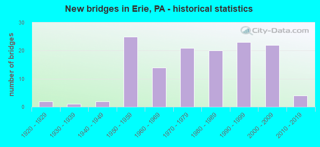
- New bridges - historical statistics
- 21920-1929
- 11930-1939
- 21940-1949
- 251950-1959
- 141960-1969
- 211970-1979
- 201980-1989
- 231990-1999
- 222000-2009
- 42010-2019
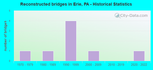
- Reconstructed bridges - Historical Statistics
- 11970-1979
- 11980-1989
- 41990-1999
- 12000-2009
- 02010-2019
- 12020-2022
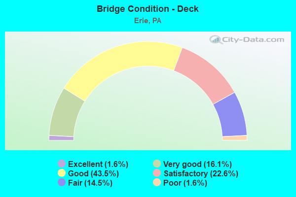
- Bridge Condition - Deck
- 1.6%Excellent
- 16.1%Very good
- 43.5%Good
- 22.6%Satisfactory
- 14.5%Fair
- 1.6%Poor
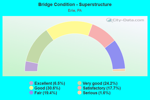
- Bridge Condition - Superstructure
- 6.5%Excellent
- 24.2%Very good
- 30.6%Good
- 17.7%Satisfactory
- 19.4%Fair
- 1.6%Serious
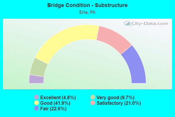
- Bridge Condition - Substructure
- 4.8%Excellent
- 9.7%Very good
- 41.9%Good
- 21.0%Satisfactory
- 22.6%Fair
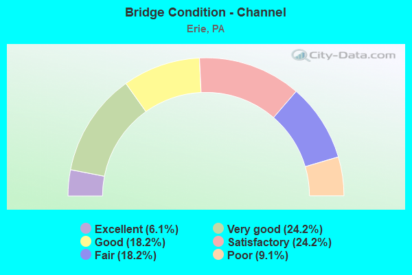
- Bridge Condition - Channel
- 6.1%Excellent
- 24.2%Very good
- 18.2%Good
- 24.2%Satisfactory
- 18.2%Fair
- 9.1%Poor
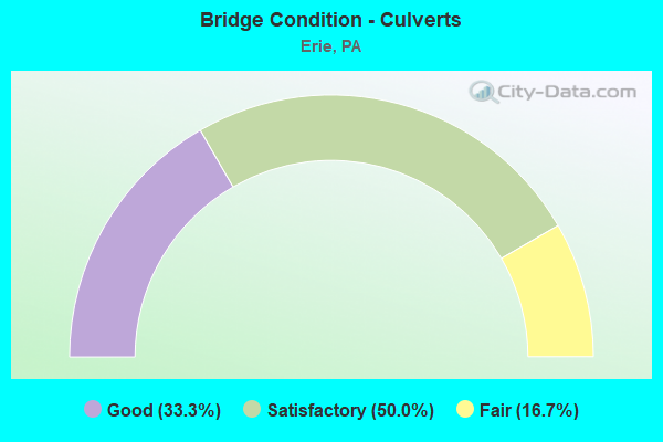
- Bridge Condition - Culverts
- 33.3%Good
- 50.0%Satisfactory
- 16.7%Fair
Find on map >> Show street view
Structure Number: 16457, Location: 1100' SE OF ZIMMERLY ROAD (Lat: 42.061094, Lng: -80.116964), Route carried "on" structure: City street 7213, Year Built: 1977, Status: Open, Structure Length: 1.55m (5.09ft), Average Daily Traffic: 504 (year 2013), Truck Traffic: 3%, Average Future Daily Traffic: 547 (year 2033), Design Load: HS 20, Features Intersected: WALNUT CREEK, Facility Carried by Structure: T-516 Old Zuck Rd
Minimum Vertical Clearance: 30+ m (98+ ft), Kilometerpoint: 0.000, Lanes on structure: 2, Owner: Town or Township Highway Agency, Approaching Roadway Width: 9.1m (29.9ft), Skew: 2 degrees, Material/Design: Concrete, Design/Construction: Culvert, Number Of Spans In Main Unit: 2, Length of Maximum Span: 7.3m (24.0ft)
Condition: Channel: Fair, Culverts: Satisfactory, Operating Rating: 71.7 metric tons, Method Used To Determine Operating Rating: Load Factor (LF), Inventory Rating: 42.6 metric tons, Method Used To Determine Inventory Rating: Load Factor (LF), Structural Evaluation: Equal to present minimum criteria, Waterway Adequacy: Superior to present desirable criteria, Approach Roadway Alignment: Equal to present desirable criteria, Length Of Structure Improvement: 2.20m (7.22ft), Designated Inspection Frequency: Every 24 months, Inspection Date: October 2021
Find on map >> Show street view
Structure Number: 16461, Location: AT LOWE ROAD INTERSECTION (Lat: 42.056308, Lng: -80.143475), Route carried "on" structure: City street 7213, Year Built: 2006, Status: Open, Structure Length: 2.93m (9.61ft), Average Daily Traffic: 1,913 (year 2015), Truck Traffic: 7%, Average Future Daily Traffic: 2,076 (year 2035), Design Load: HS 20, Features Intersected: WALNUT CREEK, Facility Carried by Structure: T-707 ZIMMERLY RD
Minimum Vertical Clearance: 30+ m (98+ ft), Kilometerpoint: 0.000, Lanes on structure: 2, Owner: Town or Township Highway Agency, Approaching Roadway Width: 9.1m (29.9ft), Skew: 1 degrees, Material/Design: Prestressed concrete, Design/Construction: Box Beam or Girders - Multiple, Number Of Spans In Main Unit: 1, Length of Maximum Span: 29.0m (95.1ft), Curb or Sidewalk Widths: Left: 0.2m (0.7ft), Right: 0.2m (0.7ft), Curb-To-Curb Width: 9.0m (29.5ft), Out-to-Out Width: 10.0m (32.8ft)
Condition: Deck: Fair, Superstructure: Fair, Substructure: Good, Channel: Satisfactory, Inventory Rating: 37.2 metric tons, Method Used To Determine Inventory Rating: Load Factor (LF), Structural Evaluation: Somewhat better than minimum adequacy, Deck Geometry: Somewhat better than minimum adequacy, Waterway Adequacy: Equal to present desirable criteria, Approach Roadway Alignment: Equal to present desirable criteria, Length Of Structure Improvement: 1.40m (4.59ft), Designated Inspection Frequency: Every 24 months, Inspection Date: October 2021, Bridge Improvement Cost: $40,000, Roadway Improvement Cost: $200,000, Total Project Cost: $800,000, Deck Structure Type: Other, Wearing Surface/Protective System: Wearing Surface: Bituminous
Find on map >> Show street view
Structure Number: 16463, Location: 200 FT S OF E. GORE RD (Lat: 42.100975, Lng: -80.033022), Route carried "on" structure: City street , Year Built: 1973, Status: Posted for load, Structure Length: 1.58m (5.18ft), Average Daily Traffic: 1,819 (year 2015), Truck Traffic: 2%, Average Future Daily Traffic: 1,974 (year 2035), Design Load: HS 20, Features Intersected: MILL CREEK, Facility Carried by Structure: T-928 CIDER MILL
Minimum Vertical Clearance: 30+ m (98+ ft), Kilometerpoint: 0.000, Lanes on structure: 2, Owner: Town or Township Highway Agency, Approaching Roadway Width: 8.5m (27.9ft), Skew: 3 degrees, Material/Design: Wood or Timber, Design/Construction: Slab, Number Of Spans In Main Unit: 2, Length of Maximum Span: 7.6m (24.9ft), Curb or Sidewalk Widths: Left: 0.2m (0.7ft), Right: 1.2m (3.9ft), Curb-To-Curb Width: 7.8m (25.6ft), Out-to-Out Width: 8.3m (27.2ft)
Condition: Deck: Fair, Superstructure: Fair, Substructure: Fair, Channel: Satisfactory, Operating Rating: 38.1 metric tons, Method Used To Determine Operating Rating: Allowable Stress (AS), Inventory Rating: 25.4 metric tons, Method Used To Determine Inventory Rating: Allowable Stress (AS), Structural Evaluation: Somewhat better than minimum adequacy, Deck Geometry: Meets minimum limits, Waterway Adequacy: Better than present minimum criteria, Approach Roadway Alignment: Equal to present desirable criteria, Bridge Posting: Required (Relationship of Operating Rating to Maximum Legal Load: 20.0 - 29.9% below), Length Of Structure Improvement: 1.60m (5.25ft), Designated Inspection Frequency: Every 24 months, Other Special Inspection Frequency: Every 12 months, Inspection Date: October 2021, Other Special Inspection Date: October 2021, Deck Structure Type: Wood or Timber, Wearing Surface/Protective System: Wearing Surface: Bituminous
Find on map >> Show street view
Structure Number: 16478, Location: 1000' SOUTH OF JOHNSON RD (Lat: 42.065561, Lng: -80.059481), Route carried "on" structure: City street 7216, Year Built: 1988, Status: Open, Structure Length: 0.79m (2.59ft), Average Daily Traffic: 2,446 (year 2013), Truck Traffic: 2%, Average Future Daily Traffic: 2,654 (year 2033), Features Intersected: WALNUT CREEK, Facility Carried by Structure: T-548 CHERRY ST
Minimum Vertical Clearance: 30+ m (98+ ft), Kilometerpoint: 0.000, Lanes on structure: 2, Owner: Town or Township Highway Agency, Approaching Roadway Width: 5.5m (18.0ft), Skew: 1 degrees, Material/Design: Concrete, Design/Construction: Culvert, Number Of Spans In Main Unit: 1, Length of Maximum Span: 7.9m (25.9ft)
Condition: Channel: Satisfactory, Culverts: Satisfactory, Operating Rating: 49.0 metric tons, Method Used To Determine Operating Rating: Field evaluation and documented engineering judgment, Inventory Rating: 32.7 metric tons, Method Used To Determine Inventory Rating: Field evaluation and documented engineering judgment, Structural Evaluation: Equal to present minimum criteria, Waterway Adequacy: Equal to present desirable criteria, Approach Roadway Alignment: Equal to present desirable criteria, Length Of Structure Improvement: 1.40m (4.59ft), Designated Inspection Frequency: Every 24 months, Inspection Date: September 2021
Find on map >> Show street view
Structure Number: 16479, Location: 150' S OF JOHNSON RD (Lat: 42.066683, Lng: -80.049375), Route carried "on" structure: City street 7216, Year Built: 1983, Status: Open, Structure Length: 0.88m (2.89ft), Average Daily Traffic: 1,706 (year 2013), Truck Traffic: 2%, Average Future Daily Traffic: 1,851 (year 2033), Features Intersected: WALNUT CREEK, Facility Carried by Structure: T-558 OLD FRENCH
Minimum Vertical Clearance: 30+ m (98+ ft), Kilometerpoint: 0.000, Lanes on structure: 2, Owner: Town or Township Highway Agency, Approaching Roadway Width: 8.2m (26.9ft), Skew: 1 degrees, Material/Design: Steel, Design/Construction: Culvert, Number Of Spans In Main Unit: 1, Length of Maximum Span: 8.8m (28.9ft)
Condition: Channel: Poor, Culverts: Satisfactory, Operating Rating: 45.4 metric tons, Method Used To Determine Operating Rating: Field evaluation and documented engineering judgment, Inventory Rating: 32.7 metric tons, Method Used To Determine Inventory Rating: Field evaluation and documented engineering judgment, Structural Evaluation: Equal to present minimum criteria, Waterway Adequacy: Equal to present desirable criteria, Approach Roadway Alignment: Equal to present desirable criteria, Length Of Structure Improvement: 1.60m (5.25ft), Designated Inspection Frequency: Every 24 months, Inspection Date: September 2021
Find on map >> Show street view
Structure Number: 16504, Location: CITY OF ERIE (Lat: 42.113333, Lng: -80.116667), Route carried "on" structure: State highway , Year Built: 1990, Status: Open, Structure Length: 0.79m (2.59ft), Average Daily Traffic: 13,002 (year 2020), Truck Traffic: 4%, Average Future Daily Traffic: 16,283 (year 2032), Design Load: HS 25 or greater, Features Intersected: OVER CASCADE CREEK, Facility Carried by Structure: SR 4034
Minimum Vertical Clearance: 30+ m (98+ ft), Kilometerpoint: 0.583, Lanes on structure: 4, Base Highway Network: Yes, Owner: State Highway Agency, Approaching Roadway Width: 19.5m (64.0ft), Skew: 5 degrees, Material/Design: Concrete, Design/Construction: Culvert, Number Of Spans In Main Unit: 2, Length of Maximum Span: 3.4m (11.2ft)
Condition: Channel: Very good, Culverts: Good, Operating Rating: 49.0 metric tons, Method Used To Determine Operating Rating: Load Factor (LF), Inventory Rating: 32.7 metric tons, Method Used To Determine Inventory Rating: Load Factor (LF), Structural Evaluation: Better than present minimum criteria, Waterway Adequacy: Superior to present desirable criteria, Approach Roadway Alignment: Equal to present desirable criteria, Length Of Structure Improvement: 1.30m (4.27ft), Designated Inspection Frequency: Every 48 months, Inspection Date: Febuary 2020
Find on map >> Show street view
Structure Number: 16505, Location: CITY OF ERIE (Lat: 42.118333, Lng: -80.116667), Route carried "on" structure: State highway , Year Built: 1990, Status: Open, Structure Length: 1.04m (3.41ft), Average Daily Traffic: 13,002 (year 2020), Truck Traffic: 4%, Average Future Daily Traffic: 16,282 (year 2032), Design Load: HS 25 or greater, Features Intersected: OVER CASCADE CREEK, Facility Carried by Structure: SR 4034
Minimum Vertical Clearance: 30+ m (98+ ft), Kilometerpoint: 1.078, Lanes on structure: 3, Base Highway Network: Yes, Owner: State Highway Agency, Approaching Roadway Width: 12.5m (41.0ft), Skew: 3 degrees, Material/Design: Prestressed concrete, Design/Construction: Box Beam or Girders - Single/Spread, Number Of Spans In Main Unit: 1, Length of Maximum Span: 10.1m (33.1ft), Curb or Sidewalk Widths: Left: 0.2m (0.7ft), Right: 0.2m (0.7ft), Curb-To-Curb Width: 12.2m (40.0ft), Out-to-Out Width: 13.2m (43.3ft)
Condition: Deck: Very good, Superstructure: Very good, Substructure: Good, Channel: Good, Operating Rating: 97.1 metric tons, Method Used To Determine Operating Rating: Load Factor (LF), Inventory Rating: 52.6 metric tons, Method Used To Determine Inventory Rating: Load Factor (LF), Structural Evaluation: Better than present minimum criteria, Deck Geometry: Meets minimum limits, Waterway Adequacy: Superior to present desirable criteria, Approach Roadway Alignment: Equal to present desirable criteria, Length Of Structure Improvement: 1.00m (3.28ft), Designated Inspection Frequency: Every 48 months, Inspection Date: Febuary 2020, Deck Structure Type: Concrete Cast-file-Place, Wearing Surface/Protective System: Wearing Surface: Bituminous, Deck Protection: Epoxy Coated Reinforcing
Find on map >> Show street view
Structure Number: 16506, Location: CITY OF ERIE (Lat: 42.120000, Lng: -80.116667), Route carried "on" structure: State highway , Year Built: 1990, Status: Open, Structure Length: 1.46m (4.79ft), Average Daily Traffic: 13,002 (year 2020), Truck Traffic: 4%, Average Future Daily Traffic: 16,282 (year 2032), Design Load: HS 25 or greater, Features Intersected: OVER CASCADE CREEK, Facility Carried by Structure: SR 4034
Minimum Vertical Clearance: 30+ m (98+ ft), Kilometerpoint: 1.078, Lanes on structure: 3, Base Highway Network: Yes, Owner: State Highway Agency, Approaching Roadway Width: 12.2m (40.0ft), Skew: 4 degrees, Material/Design: Prestressed concrete, Design/Construction: Box Beam or Girders - Single/Spread, Number Of Spans In Main Unit: 1, Length of Maximum Span: 14.6m (47.9ft), Curb or Sidewalk Widths: Left: 0.2m (0.7ft), Right: 0.2m (0.7ft), Curb-To-Curb Width: 12.2m (40.0ft), Out-to-Out Width: 13.3m (43.6ft)
Condition: Deck: Very good, Superstructure: Very good, Substructure: Good, Channel: Good, Operating Rating: 72.6 metric tons, Method Used To Determine Operating Rating: Load Factor (LF), Inventory Rating: 43.5 metric tons, Method Used To Determine Inventory Rating: Load Factor (LF), Structural Evaluation: Better than present minimum criteria, Deck Geometry: Meets minimum limits, Waterway Adequacy: Superior to present desirable criteria, Approach Roadway Alignment: Equal to present desirable criteria, Length Of Structure Improvement: 1.50m (4.92ft), Designated Inspection Frequency: Every 48 months, Inspection Date: Febuary 2020, Deck Structure Type: Concrete Cast-file-Place, Wearing Surface/Protective System: Wearing Surface: Bituminous, Deck Protection: Epoxy Coated Reinforcing
Find on map >> Show street view
Structure Number: 16507, Location: 500FT SW of Penn. Ave. (Lat: 42.125300, Lng: -80.053100), Route carried "on" structure: City street 7302, Year Built: 2004, Status: Open, Structure Length: 5.64m (18.50ft), Average Daily Traffic: 6,342 (year 2013), Truck Traffic: 5%, Average Future Daily Traffic: 6,881 (year 2033), Design Load: HL 93, Features Intersected: OVER NSRC & SR 0290, Facility Carried by Structure: BUFFALO ROAD
Minimum Vertical Clearance: 30+ m (98+ ft), Kilometerpoint: 0.000, Lanes on structure: 2, Lanes under structure: 8, Owner: Railroad, Maintenance Responsibility: City or Municipal Highway Agency, Approaching Roadway Width: 9.8m (32.2ft), Skew: 3 degrees, Material/Design: Prestressed concrete, Design/Construction: Box Beam or Girders - Single/Spread, Number Of Spans In Main Unit: 2, Length of Maximum Span: 38.7m (127.0ft), Curb or Sidewalk Widths: Left: 0.1m (0.3ft), Right: 2.0m (6.6ft), Curb-To-Curb Width: 9.8m (32.2ft), Out-to-Out Width: 12.9m (42.3ft)
Condition: Deck: Good, Superstructure: Satisfactory, Substructure: Very good, Operating Rating: 63.5 metric tons, Method Used To Determine Operating Rating: Load and Resistance Factor (LRFR), Inventory Rating: 42.6 metric tons, Method Used To Determine Inventory Rating: Load and Resistance Factor (LRFR), Structural Evaluation: Equal to present minimum criteria, Deck Geometry: Meets minimum limits, Underclear: Superior to present desirable criteria, Approach Roadway Alignment: Better than present minimum criteria, Length Of Structure Improvement: 6.60m (21.65ft), Designated Inspection Frequency: Every 24 months, Inspection Date: November 2021, Deck Structure Type: Concrete Cast-file-Place, Wearing Surface/Protective System: Wearing Surface: Monolithic Concrete, Deck Protection: Epoxy Coated Reinforcing
Find on map >> Show street view
Structure Number: 16509, Location: 200 FT.S.OF E. 12TH ST. (Lat: 42.138597, Lng: -80.031675), Route carried "on" structure: City street 7302, Year Built: 1943, Year Reconstructed: 1990, Status: Open, Structure Length: 11.09m (36.38ft), Average Daily Traffic: 9,462 (year 2013), Truck Traffic: 5%, Average Future Daily Traffic: 10,266 (year 2033), Design Load: HS 25 or greater, Features Intersected: OVER BNSF & CSX RR, Facility Carried by Structure: FRANKLIN AVENUE
Minimum Vertical Clearance: 30+ m (98+ ft), Kilometerpoint: 0.000, Lanes on structure: 2, Lanes under structure: 2, Base Highway Network: Yes, Owner: City or Municipal Highway Agency, Approaching Roadway Width: 8.5m (27.9ft), Material/Design: Prestressed concrete continuous, Design/Construction: Box Beam or Girders - Single/Spread, Number Of Spans In Main Unit: 7, Length of Maximum Span: 25.0m (82.0ft), Curb or Sidewalk Widths: Left: 1.5m (4.9ft), Right: 1.5m (4.9ft), Curb-To-Curb Width: 8.5m (27.9ft), Out-to-Out Width: 12.2m (40.0ft)
Condition: Deck: Good, Superstructure: Satisfactory, Substructure: Good, Operating Rating: 63.5 metric tons, Method Used To Determine Operating Rating: Load Factor (LF), Inventory Rating: 28.1 metric tons, Method Used To Determine Inventory Rating: Load Factor (LF), Structural Evaluation: Equal to present minimum criteria, Deck Geometry: Meets minimum limits, Underclear: Equal to present minimum criteria, Approach Roadway Alignment: Equal to present minimum criteria, Length Of Structure Improvement: 12.00m (39.37ft), Designated Inspection Frequency: Every 24 months, Inspection Date: November 2021, Deck Structure Type: Concrete Cast-file-Place
Find on map >> Show street view
Structure Number: 16512, Location: UNDER CITY OF ERIE (Lat: 42.107967, Lng: -80.073189), Route carried "on" structure: City street 7302, Year Built: 1920, Status: Open, Structure Length: 0.67m (2.20ft), Average Daily Traffic: 8,327 (year 2009), Truck Traffic: 5%, Average Future Daily Traffic: 8,500 (year 2029), Features Intersected: OVER MILL CREEK, Facility Carried by Structure: VARIOUS STREETS
Minimum Vertical Clearance: 30+ m (98+ ft), Kilometerpoint: 0.000, Lanes on structure: 2, Owner: City or Municipal Highway Agency, Approaching Roadway Width: 7.3m (24.0ft), Skew: 9 degrees, Material/Design: Concrete, Design/Construction: Culvert, Number Of Spans In Main Unit: 1, Length of Maximum Span: 6.7m (22.0ft)
Condition: Channel: Good, Culverts: Fair, Operating Rating: 62.6 metric tons, Method Used To Determine Operating Rating: Field evaluation and documented engineering judgment, Inventory Rating: 37.2 metric tons, Method Used To Determine Inventory Rating: Field evaluation and documented engineering judgment, Structural Evaluation: Somewhat better than minimum adequacy, Waterway Adequacy: Better than present minimum criteria, Approach Roadway Alignment: Equal to present desirable criteria, Length Of Structure Improvement: 1.30m (4.27ft), Designated Inspection Frequency: Every 24 months, Inspection Date: September 2021, Bridge Improvement Cost: $3,000, Roadway Improvement Cost: $9,000, Total Project Cost: $43,000
Find on map >> Show street view
Structure Number: 16514, Location: CITY OF ERIE (Lat: 42.134117, Lng: -80.088908), Route carried "on" structure: State highway , Year Built: 1990, Status: Open, Structure Length: 4.91m (16.11ft), Average Daily Traffic: 13,002 (year 2020), Truck Traffic: 4%, Average Future Daily Traffic: 16,282 (year 2032), Design Load: HS 25 or greater, Features Intersected: OVER CSX RAILROAD, Facility Carried by Structure: SR 4034
Minimum Vertical Clearance: 30+ m (98+ ft), Kilometerpoint: 3.655, Lanes on structure: 4, Base Highway Network: Yes, Owner: State Highway Agency, Approaching Roadway Width: 15.8m (51.8ft), Material/Design: Prestressed concrete, Design/Construction: Box Beam or Girders - Single/Spread, Number Of Spans In Main Unit: 1, Length of Maximum Span: 48.5m (159.1ft), Curb or Sidewalk Widths: Left: 0.0m, Right: 2.5m (8.2ft), Curb-To-Curb Width: 16.3m (53.5ft), Out-to-Out Width: 16.3m (53.5ft)
Condition: Deck: Good, Superstructure: Good, Substructure: Good, Operating Rating: 79.8 metric tons, Method Used To Determine Operating Rating: Load Factor (LF), Inventory Rating: 48.1 metric tons, Method Used To Determine Inventory Rating: Load Factor (LF), Structural Evaluation: Better than present minimum criteria, Deck Geometry: Meets minimum limits, Underclear: High priority of corrective action, Approach Roadway Alignment: Better than present minimum criteria, Length Of Structure Improvement: 4.90m (16.08ft), Designated Inspection Frequency: Every 48 months, Inspection Date: Febuary 2020, Deck Structure Type: Concrete Cast-file-Place, Wearing Surface/Protective System: Wearing Surface: Monolithic Concrete, Deck Protection: Epoxy Coated Reinforcing
Find on map >> Show street view
Structure Number: 16515, Location: 0.3 MI.E.OF PEACH STREET (Lat: 42.098328, Lng: -80.076011), Route carried "on" structure: ServiceCity street 7302, Year Built: 1934, Status: Closed, Structure Length: 1.37m (4.49ft), Features Intersected: OVER MILL CREEK, Facility Carried by Structure: ERIE ZOO DRIVE
Minimum Vertical Clearance: 30+ m (98+ ft), Kilometerpoint: 0.000, Lanes on structure: 2, Owner: City or Municipal Highway Agency, Approaching Roadway Width: 7.3m (24.0ft), Material/Design: Steel, Design/Construction: Girder and Floorbeam System, Number Of Spans In Main Unit: 1, Length of Maximum Span: 13.7m (44.9ft), Curb or Sidewalk Widths: Left: 2.0m (6.6ft), Right: 2.0m (6.6ft), Curb-To-Curb Width: 7.4m (24.3ft), Out-to-Out Width: 11.5m (37.7ft)
Condition: Deck: Poor, Superstructure: Serious, Substructure: Fair, Channel: Fair, Operating Rating: 48.1 metric tons, Method Used To Determine Operating Rating: Load Factor (LF), Inventory Rating: 29.0 metric tons, Method Used To Determine Inventory Rating: Load Factor (LF), Structural Evaluation: High priority of corrective action, Deck Geometry: Equal to present minimum criteria, Waterway Adequacy: Better than present minimum criteria, Approach Roadway Alignment: Equal to present desirable criteria, Length Of Structure Improvement: 1.40m (4.59ft), Designated Inspection Frequency: Every 24 months, Critical Feature Inspection Frequency: Every 24 months, Inspection Date: October 2021, Critical Feature Inspection Date: October 2021, Bridge Improvement Cost: $25,000, Roadway Improvement Cost: $15,000, Total Project Cost: $476,000, Deck Structure Type: Concrete Cast-file-Place, Wearing Surface/Protective System: Wearing Surface: Bituminous
Find on map >> Show street view
Structure Number: 16529, Location: CITY OF ERIE (Lat: 42.093803, Lng: -80.121797), Route carried "on" structure: Ramp State highway , Year Built: 1972, Status: Open, Structure Length: 14.66m (48.10ft), Average Daily Traffic: 2,714 (year 2021), Truck Traffic: 7%, Average Future Daily Traffic: 3,736 (year 2032), Design Load: HS 20+Mod, Features Intersected: OVER SR 20,RAMP C,SR 79, Facility Carried by Structure: RAMP B FROM SR 79
Minimum Vertical Clearance: 30+ m (98+ ft), Kilometerpoint: 0.000, Lanes on structure: 1, Lanes under structure: 28, Base Highway Network: Yes, Owner: State Highway Agency, Approaching Roadway Width: 4.3m (14.1ft), Skew: 9 degrees, Material/Design: Steel continuous, Design/Construction: Stringer/Multi-beam, Number Of Spans In Main Unit: 5, Length of Maximum Span: 32.9m (107.9ft), Curb or Sidewalk Widths: Left: 0.2m (0.7ft), Right: 0.2m (0.7ft), Curb-To-Curb Width: 9.2m (30.2ft), Out-to-Out Width: 10.5m (34.4ft)
Condition: Deck: Fair, Superstructure: Fair, Substructure: Satisfactory, Operating Rating: 38.1 metric tons, Method Used To Determine Operating Rating: Load Factor (LF), Inventory Rating: 24.5 metric tons, Method Used To Determine Inventory Rating: Load Factor (LF), Structural Evaluation: Somewhat better than minimum adequacy, Deck Geometry: Superior to present desirable criteria, Underclear: High priority of corrective action, Approach Roadway Alignment: Better than present minimum criteria, Length Of Structure Improvement: 15.50m (50.85ft), Designated Inspection Frequency: Every 24 months, Inspection Date: August 2021, Bridge Improvement Cost: $151,000, Roadway Improvement Cost: $444,000, Total Project Cost: $2,035,000, Deck Structure Type: Concrete Cast-file-Place, Wearing Surface/Protective System: Wearing Surface: Bituminous, Membrane: Preformed Fabric
Find on map >> Show street view
Structure Number: 1653, Location: CITY OF ERIE (Lat: 42.093556, Lng: -80.121467), Route carried "on" structure: Ramp State highway , Year Built: 1972, Status: Open, Structure Length: 8.44m (27.69ft), Average Daily Traffic: 3,400 (year 2021), Truck Traffic: 7%, Average Future Daily Traffic: 1,425 (year 2032), Design Load: HS 20+Mod, Features Intersected: OVER SR 79,N.B & S.B., Facility Carried by Structure: RAMP C FROM SR 20
Minimum Vertical Clearance: 4.88m (16.01ft), Kilometerpoint: 0.000, Lanes on structure: 1, Lanes under structure: 8, Base Highway Network: Yes, Owner: State Highway Agency, Approaching Roadway Width: 7.3m (24.0ft), Skew: 4 degrees, Material/Design: Steel continuous, Design/Construction: Stringer/Multi-beam, Number Of Spans In Main Unit: 2, Number Of Approach Spans: 2, Length of Maximum Span: 32.9m (107.9ft), Curb or Sidewalk Widths: Left: 0.2m (0.7ft), Right: 0.2m (0.7ft), Curb-To-Curb Width: 9.1m (29.9ft), Out-to-Out Width: 10.4m (34.1ft)
Condition: Deck: Good, Superstructure: Fair, Substructure: Satisfactory, Operating Rating: 42.6 metric tons, Method Used To Determine Operating Rating: Load Factor (LF), Inventory Rating: 25.4 metric tons, Method Used To Determine Inventory Rating: Load Factor (LF), Structural Evaluation: Somewhat better than minimum adequacy, Deck Geometry: Meets minimum limits, Underclear: Equal to present minimum criteria, Approach Roadway Alignment: Better than present minimum criteria, Length Of Structure Improvement: 9.40m (30.84ft), Designated Inspection Frequency: Every 24 months, Inspection Date: September 2021, Bridge Improvement Cost: $19,000, Roadway Improvement Cost: $55,000, Total Project Cost: $254,000, Deck Structure Type: Concrete Cast-file-Place, Wearing Surface/Protective System: Wearing Surface: Bituminous, Membrane: Preformed Fabric
Find on map >> Show street view
Structure Number: 39534, Location: SUMMIT TOWNSHIP (Lat: 42.065122, Lng: -80.048989), Route carried "on" structure: Interstate 90, Year Built: 1996, Status: Open, Structure Length: 1.49m (4.89ft), Average Daily Traffic: 29,584 (year 2021), Truck Traffic: 20%, Average Future Daily Traffic: 21,602 (year 2032), Design Load: HS 25 or greater, Features Intersected: OVER T-558,OLD FRENCH RD
Minimum Vertical Clearance: 30+ m (98+ ft), Kilometerpoint: 41.795, Lanes on structure: 2, Lanes under structure: 2, Base Highway Network: Yes, Owner: State Highway Agency, Approaching Roadway Width: 11.6m (38.1ft), Skew: 12 degrees, Material/Design: Prestressed concrete, Design/Construction: Box Beam or Girders - Single/Spread, Number Of Spans In Main Unit: 1, Length of Maximum Span: 14.3m (46.9ft), Curb or Sidewalk Widths: Left: 0.2m (0.7ft), Right: 0.2m (0.7ft), Curb-To-Curb Width: 12.8m (42.0ft), Out-to-Out Width: 14.0m (45.9ft)
Condition: Deck: Good, Superstructure: Very good, Substructure: Good, Operating Rating: 75.3 metric tons, Method Used To Determine Operating Rating: Load Factor (LF), Inventory Rating: 40.8 metric tons, Method Used To Determine Inventory Rating: Load Factor (LF), Structural Evaluation: Better than present minimum criteria, Deck Geometry: Equal to present desirable criteria, Underclear: Superior to present desirable criteria, Approach Roadway Alignment: Equal to present desirable criteria, Length Of Structure Improvement: 2.20m (7.22ft), Designated Inspection Frequency: Every 48 months, Inspection Date: June 2019, Deck Structure Type: Concrete Cast-file-Place, Wearing Surface/Protective System: Wearing Surface: Epoxy Overlay, Membrane: Epoxy, Deck Protection: Epoxy Coated Reinforcing
Find on map >> Show street view
Structure Number: 39591, Location: SUMMIT TOWNSHIP (Lat: 42.077817, Lng: -80.027878), Route carried "on" structure: Interstate 90, Year Built: 1997, Status: Open, Structure Length: 3.72m (12.20ft), Average Daily Traffic: 23,543 (year 2021), Truck Traffic: 17%, Average Future Daily Traffic: 21,530 (year 2032), Design Load: HS 25 or greater, Features Intersected: OVER ALLEGHENY RAILROAD
Minimum Vertical Clearance: 30+ m (98+ ft), Kilometerpoint: 44.241, Lanes on structure: 2, Base Highway Network: Yes, Owner: State Highway Agency, Approaching Roadway Width: 12.5m (41.0ft), Skew: 14 degrees, Material/Design: Prestressed concrete, Design/Construction: Box Beam or Girders - Multiple, Number Of Spans In Main Unit: 1, Length of Maximum Span: 35.7m (117.1ft), Curb or Sidewalk Widths: Left: 0.2m (0.7ft), Right: 0.2m (0.7ft), Curb-To-Curb Width: 12.8m (42.0ft), Out-to-Out Width: 13.9m (45.6ft)
Condition: Deck: Good, Superstructure: Good, Substructure: Good, Operating Rating: 89.8 metric tons, Method Used To Determine Operating Rating: Load Factor (LF), Inventory Rating: 50.8 metric tons, Method Used To Determine Inventory Rating: Load Factor (LF), Structural Evaluation: Better than present minimum criteria, Deck Geometry: Equal to present desirable criteria, Underclear: High priority of corrective action, Approach Roadway Alignment: Equal to present desirable criteria, Length Of Structure Improvement: 4.70m (15.42ft), Designated Inspection Frequency: Every 48 months, Inspection Date: August 2020, Deck Structure Type: Concrete Cast-file-Place, Wearing Surface/Protective System: Wearing Surface: Epoxy Overlay, Membrane: Epoxy, Deck Protection: Epoxy Coated Reinforcing
Find on map >> Show street view
Structure Number: 40386, Location: 1200' S OF ZIMMERLY RD (Lat: 42.057867, Lng: -80.131706), Route carried "on" structure: City street 7213, Year Built: 1996, Status: Open, Structure Length: 2.50m (8.20ft), Average Daily Traffic: 1,567 (year 2015), Truck Traffic: 1%, Average Future Daily Traffic: 1,700 (year 2035), Design Load: HS 25 or greater, Features Intersected: WALNUT CREEK, Facility Carried by Structure: T-461 GARRIES ROAD
Minimum Vertical Clearance: 30+ m (98+ ft), Kilometerpoint: 0.000, Lanes on structure: 2, Owner: Town or Township Highway Agency, Approaching Roadway Width: 8.2m (26.9ft), Skew: 2 degrees, Material/Design: Prestressed concrete, Design/Construction: Box Beam or Girders - Multiple, Number Of Spans In Main Unit: 1, Length of Maximum Span: 24.7m (81.0ft), Curb or Sidewalk Widths: Left: 0.2m (0.7ft), Right: 0.2m (0.7ft), Curb-To-Curb Width: 8.8m (28.9ft), Out-to-Out Width: 10.0m (32.8ft)
Condition: Deck: Fair, Superstructure: Fair, Substructure: Good, Channel: Satisfactory, Operating Rating: 83.5 metric tons, Method Used To Determine Operating Rating: Load Factor (LF), Inventory Rating: 27.2 metric tons, Method Used To Determine Inventory Rating: Load Factor (LF), Structural Evaluation: Somewhat better than minimum adequacy, Deck Geometry: Somewhat better than minimum adequacy, Waterway Adequacy: Superior to present desirable criteria, Approach Roadway Alignment: Equal to present desirable criteria, Length Of Structure Improvement: 3.20m (10.50ft), Designated Inspection Frequency: Every 24 months, Inspection Date: October 2021, Deck Structure Type: Other, Wearing Surface/Protective System: Wearing Surface: Bituminous
Find on map >> Show street view
Structure Number: 4083, Location: CITY OF ERIE (Lat: 42.119506, Lng: -80.114236), Route carried "on" structure: Alternate State highway , Year Built: 1998, Status: Open, Structure Length: 7.62m (25.00ft), Average Daily Traffic: 7,131 (year 2013), Truck Traffic: 3%, Average Future Daily Traffic: 7,737 (year 2033), Design Load: HS 25 or greater, Features Intersected: OVER SR 4034, Facility Carried by Structure: WEST 6TH STREET
Minimum Vertical Clearance: 30+ m (98+ ft), Kilometerpoint: 0.000, Lanes on structure: 2, Lanes under structure: 3, Owner: City or Municipal Highway Agency, Approaching Roadway Width: 11.0m (36.1ft), Skew: 2 degrees, Material/Design: Steel continuous, Design/Construction: Stringer/Multi-beam, Number Of Spans In Main Unit: 2, Length of Maximum Span: 38.1m (125.0ft), Curb or Sidewalk Widths: Left: 2.0m (6.6ft), Right: 3.3m (10.8ft), Curb-To-Curb Width: 11.0m (36.1ft), Out-to-Out Width: 16.9m (55.4ft)
Condition: Deck: Good, Superstructure: Good, Substructure: Good, Channel: Satisfactory, Operating Rating: 80.7 metric tons, Method Used To Determine Operating Rating: Load Factor (LF), Inventory Rating: 48.1 metric tons, Method Used To Determine Inventory Rating: Load Factor (LF), Structural Evaluation: Better than present minimum criteria, Deck Geometry: Meets minimum limits, Underclear: Superior to present desirable criteria, Waterway Adequacy: Superior to present desirable criteria, Approach Roadway Alignment: Better than present minimum criteria, Length Of Structure Improvement: 8.60m (28.22ft), Designated Inspection Frequency: Every 24 months, Inspection Date: November 2021, Deck Structure Type: Concrete Cast-file-Place, Wearing Surface/Protective System: Wearing Surface: Monolithic Concrete, Deck Protection: Epoxy Coated Reinforcing
Find on map >> Show street view
Structure Number: 40919, Location: CITY OF ERIE (Lat: 42.089244, Lng: -80.118483), Route carried "on" structure: Interstate 79, Year Built: 2000, Status: Open, Structure Length: 3.08m (10.10ft), Average Daily Traffic: 15,393 (year 2021), Truck Traffic: 5%, Average Future Daily Traffic: 21,053 (year 2032), Design Load: HS 25 or greater, Features Intersected: OVER WEST 32ND STREET
Minimum Vertical Clearance: 30+ m (98+ ft), Kilometerpoint: 28.936, Lanes on structure: 3, Lanes under structure: 2, Base Highway Network: Yes, Owner: State Highway Agency, Approaching Roadway Width: 15.8m (51.8ft), Skew: 10 degrees, Material/Design: Prestressed concrete, Design/Construction: Box Beam or Girders - Multiple, Number Of Spans In Main Unit: 1, Length of Maximum Span: 30.2m (99.1ft), Curb or Sidewalk Widths: Left: 0.1m (0.3ft), Right: 0.1m (0.3ft), Curb-To-Curb Width: 17.7m (58.1ft), Out-to-Out Width: 18.6m (61.0ft)
Condition: Deck: Good, Superstructure: Good, Substructure: Good, Operating Rating: 72.6 metric tons, Method Used To Determine Operating Rating: Load and Resistance Factor (LRFR), Inventory Rating: 44.5 metric tons, Method Used To Determine Inventory Rating: Load and Resistance Factor (LRFR), Structural Evaluation: Better than present minimum criteria, Deck Geometry: Better than present minimum criteria, Underclear: Equal to present minimum criteria, Approach Roadway Alignment: Equal to present desirable criteria, Length Of Structure Improvement: 3.80m (12.47ft), Designated Inspection Frequency: Every 24 months, Inspection Date: May 2020, Deck Structure Type: Concrete Cast-file-Place, Wearing Surface/Protective System: Wearing Surface: Bituminous, Membrane: Preformed Fabric, Deck Protection: Epoxy Coated Reinforcing
Find on map >> Show street view
Structure Number: 40941, Location: MILL CREEK TOWNSHIP (Lat: 42.072131, Lng: -80.107047), Route carried "on" structure: Interstate 79, Year Built: 2000, Status: Open, Structure Length: 2.87m (9.42ft), Average Daily Traffic: 15,393 (year 2021), Truck Traffic: 5%, Average Future Daily Traffic: 21,053 (year 2032), Design Load: HS 25 or greater, Features Intersected: OVER WALNUT CREEK
Minimum Vertical Clearance: 30+ m (98+ ft), Kilometerpoint: 26.532, Lanes on structure: 2, Base Highway Network: Yes, Owner: State Highway Agency, Approaching Roadway Width: 13.7m (44.9ft), Skew: 10 degrees, Material/Design: Prestressed concrete, Design/Construction: Stringer/Multi-beam, Number Of Spans In Main Unit: 1, Length of Maximum Span: 27.7m (90.9ft), Curb or Sidewalk Widths: Left: 0.1m (0.3ft), Right: 0.1m (0.3ft), Curb-To-Curb Width: 13.4m (44.0ft), Out-to-Out Width: 14.3m (46.9ft)
Condition: Deck: Very good, Superstructure: Excellent, Substructure: Excellent, Channel: Very good, Inventory Rating: 38.1 metric tons, Method Used To Determine Inventory Rating: Load Factor (LF), Structural Evaluation: Superior to present desirable criteria, Deck Geometry: Superior to present desirable criteria, Waterway Adequacy: Superior to present desirable criteria, Approach Roadway Alignment: Equal to present desirable criteria, Length Of Structure Improvement: 3.60m (11.81ft), Designated Inspection Frequency: Every 48 months, Inspection Date: August 2020, Deck Structure Type: Concrete Cast-file-Place, Wearing Surface/Protective System: Wearing Surface: Bituminous, Membrane: Preformed Fabric, Deck Protection: Epoxy Coated Reinforcing
Find on map >> Show street view
Structure Number: 4123, Location: MILL CREEK TOWNSHIP (Lat: 42.072000, Lng: -80.107433), Route carried "on" structure: Interstate 79, Year Built: 2001, Status: Open, Structure Length: 2.87m (9.42ft), Average Daily Traffic: 15,192 (year 2021), Truck Traffic: 5%, Average Future Daily Traffic: 20,632 (year 2032), Design Load: HS 25 or greater, Features Intersected: OVER WALNUT CREEK
Minimum Vertical Clearance: 30+ m (98+ ft), Kilometerpoint: 26.567, Lanes on structure: 2, Base Highway Network: Yes, Owner: State Highway Agency, Approaching Roadway Width: 16.2m (53.1ft), Skew: 10 degrees, Material/Design: Prestressed concrete, Design/Construction: Stringer/Multi-beam, Number Of Spans In Main Unit: 1, Length of Maximum Span: 28.0m (91.9ft), Curb or Sidewalk Widths: Left: 0.1m (0.3ft), Right: 0.1m (0.3ft), Curb-To-Curb Width: 15.9m (52.2ft), Out-to-Out Width: 16.9m (55.4ft)
Condition: Deck: Very good, Superstructure: Very good, Substructure: Very good, Channel: Very good, Inventory Rating: 46.3 metric tons, Method Used To Determine Inventory Rating: Load Factor (LF), Structural Evaluation: Equal to present desirable criteria, Deck Geometry: Superior to present desirable criteria, Waterway Adequacy: Superior to present desirable criteria, Approach Roadway Alignment: Equal to present desirable criteria, Length Of Structure Improvement: 3.60m (11.81ft), Designated Inspection Frequency: Every 24 months, Inspection Date: August 2020, Deck Structure Type: Concrete Cast-file-Place, Wearing Surface/Protective System: Wearing Surface: Bituminous, Membrane: Preformed Fabric, Deck Protection: Epoxy Coated Reinforcing
Find on map >> Show street view
Structure Number: 41231, Location: CITY OF ERIE (Lat: 42.089175, Lng: -80.118694), Route carried "on" structure: Interstate 79, Year Built: 2001, Status: Open, Structure Length: 3.14m (10.30ft), Average Daily Traffic: 15,192 (year 2021), Truck Traffic: 5%, Average Future Daily Traffic: 20,632 (year 2032), Design Load: HS 25 or greater, Features Intersected: OVER WEST 32ND STREET
Minimum Vertical Clearance: 30+ m (98+ ft), Kilometerpoint: 28.994, Lanes on structure: 2, Lanes under structure: 2, Base Highway Network: Yes, Owner: State Highway Agency, Approaching Roadway Width: 15.2m (49.9ft), Skew: 10 degrees, Material/Design: Prestressed concrete, Design/Construction: Box Beam or Girders - Multiple, Number Of Spans In Main Unit: 1, Length of Maximum Span: 30.8m (101.0ft), Curb or Sidewalk Widths: Left: 0.1m (0.3ft), Right: 0.1m (0.3ft), Curb-To-Curb Width: 16.4m (53.8ft), Out-to-Out Width: 17.3m (56.8ft)
Condition: Deck: Good, Superstructure: Good, Substructure: Good, Operating Rating: 77.1 metric tons, Method Used To Determine Operating Rating: Load and Resistance Factor (LRFR), Inventory Rating: 52.6 metric tons, Method Used To Determine Inventory Rating: Load and Resistance Factor (LRFR), Structural Evaluation: Better than present minimum criteria, Deck Geometry: Superior to present desirable criteria, Underclear: Equal to present minimum criteria, Approach Roadway Alignment: Equal to present desirable criteria, Length Of Structure Improvement: 3.90m (12.80ft), Designated Inspection Frequency: Every 48 months, Inspection Date: May 2020, Deck Structure Type: Concrete Cast-file-Place, Wearing Surface/Protective System: Wearing Surface: Bituminous, Membrane: Preformed Fabric, Deck Protection: Epoxy Coated Reinforcing
Find on map >> Show street view
Structure Number: 42021, Location: GREEN TOWNSHIP (Lat: 42.082283, Lng: -80.021969), Route carried "on" structure: State highway , Year Built: 2003, Status: Open, Structure Length: 5.55m (18.21ft), Average Daily Traffic: 2,113 (year 2021), Truck Traffic: 5%, Average Future Daily Traffic: 3,847 (year 2032), Design Load: HS 25 or greater, Features Intersected: OVER SR 90,EB/WB, Facility Carried by Structure: SR 1001,LK.PLSNT.R
Minimum Vertical Clearance: 30+ m (98+ ft), Kilometerpoint: 20.402, Lanes on structure: 2, Lanes under structure: 8, Base Highway Network: Yes, Owner: State Highway Agency, Approaching Roadway Width: 8.8m (28.9ft), Material/Design: Prestressed concrete continuous, Design/Construction: Box Beam or Girders - Multiple, Number Of Spans In Main Unit: 2, Length of Maximum Span: 27.1m (88.9ft), Curb or Sidewalk Widths: Left: 0.2m (0.7ft), Right: 0.2m (0.7ft), Curb-To-Curb Width: 10.4m (34.1ft), Out-to-Out Width: 11.2m (36.7ft)
Condition: Deck: Good, Superstructure: Good, Substructure: Good, Operating Rating: 80.7 metric tons, Method Used To Determine Operating Rating: Load Factor (LF), Inventory Rating: 36.3 metric tons, Method Used To Determine Inventory Rating: Load Factor (LF), Structural Evaluation: Better than present minimum criteria, Deck Geometry: Somewhat better than minimum adequacy, Underclear: Somewhat better than minimum adequacy, Approach Roadway Alignment: Better than present minimum criteria, Length Of Structure Improvement: 6.50m (21.33ft), Designated Inspection Frequency: Every 24 months, Inspection Date: July 2020, Deck Structure Type: Concrete Cast-file-Place, Wearing Surface/Protective System: Wearing Surface: Monolithic Concrete, Deck Protection: Epoxy Coated Reinforcing
Find on map >> Show street view
Structure Number: 42158, Location: CITY OF ERIE (Lat: 42.101639, Lng: -80.076006), Route carried "on" structure: State highway 505, Year Built: 2003, Status: Open, Structure Length: 1.65m (5.41ft), Average Daily Traffic: 9,095 (year 2020), Truck Traffic: 5%, Average Future Daily Traffic: 9,666 (year 2032), Design Load: HL 93, Features Intersected: OVER MILL CREEK
Minimum Vertical Clearance: 30+ m (98+ ft), Kilometerpoint: 3.201, Lanes on structure: 4, Owner: State Highway Agency, Approaching Roadway Width: 15.8m (51.8ft), Skew: 4 degrees, Material/Design: Concrete, Design/Construction: Culvert, Number Of Spans In Main Unit: 2, Length of Maximum Span: 6.7m (22.0ft), Curb or Sidewalk Widths: Left: 2.0m (6.6ft), Right: 0.0m
Condition: Channel: Very good, Culverts: Good, Operating Rating: 76.2 metric tons, Method Used To Determine Operating Rating: Load Factor (LF), Inventory Rating: 32.7 metric tons, Method Used To Determine Inventory Rating: Load Factor (LF), Structural Evaluation: Better than present minimum criteria, Waterway Adequacy: Equal to present desirable criteria, Approach Roadway Alignment: Equal to present desirable criteria, Length Of Structure Improvement: 2.30m (7.55ft), Designated Inspection Frequency: Every 48 months, Inspection Date: May 2020
Find on map >> Show street view
Structure Number: 42301, Location: CITY OF ERIE (Lat: 41.949083, Lng: -80.492014), Route carried "on" structure: State highway 5, Year Built: 2002, Status: Open, Structure Length: 1.43m (4.69ft), Average Daily Traffic: 9,471 (year 2021), Truck Traffic: 5%, Average Future Daily Traffic: 14,248 (year 2032), Design Load: HS 25 or greater, Features Intersected: OVER RAILROAD
Minimum Vertical Clearance: 30+ m (98+ ft), Kilometerpoint: 41.742, Lanes on structure: 5, Base Highway Network: Yes, Owner: State Highway Agency, Approaching Roadway Width: 18.6m (61.0ft), Material/Design: Prestressed concrete, Design/Construction: Box Beam or Girders - Multiple, Number Of Spans In Main Unit: 1, Length of Maximum Span: 14.0m (45.9ft), Curb or Sidewalk Widths: Left: 2.3m (7.5ft), Right: 2.3m (7.5ft), Curb-To-Curb Width: 18.6m (61.0ft), Out-to-Out Width: 23.7m (77.8ft)
Condition: Deck: Good, Superstructure: Very good, Substructure: Good, Operating Rating: 58.1 metric tons, Method Used To Determine Operating Rating: Load Factor (LF), Inventory Rating: 39.0 metric tons, Method Used To Determine Inventory Rating: Load Factor (LF), Structural Evaluation: Better than present minimum criteria, Deck Geometry: High priority of corrective action, Underclear: High priority of corrective action, Approach Roadway Alignment: Better than present minimum criteria, Length Of Structure Improvement: 2.10m (6.89ft), Designated Inspection Frequency: Every 24 months, Inspection Date: August 2020, Deck Structure Type: Concrete Cast-file-Place, Wearing Surface/Protective System: Wearing Surface: Monolithic Concrete, Deck Protection: Epoxy Coated Reinforcing
Find on map >> Show street view
Structure Number: 42589, Location: CITY ERIE (Lat: 42.123967, Lng: -80.043075), Route carried "on" structure: State highway 290, Year Built: 2004, Status: Open, Structure Length: 2.56m (8.40ft), Average Daily Traffic: 13,504 (year 2022), Truck Traffic: 3%, Average Future Daily Traffic: 19,517 (year 2032), Design Load: HL 93, Features Intersected: BROAD ST./S.R.20, Facility Carried by Structure: EAST ACCESS HWY.
Minimum Vertical Clearance: 30+ m (98+ ft), Kilometerpoint: 1.687, Lanes on structure: 4, Lanes under structure: 8, Base Highway Network: Yes, Owner: State Highway Agency, Approaching Roadway Width: 10.1m (33.1ft), Skew: 31 degrees, Material/Design: Prestressed concrete, Design/Construction: Box Beam or Girders - Single/Spread, Number Of Spans In Main Unit: 1, Length of Maximum Span: 25.3m (83.0ft), Curb or Sidewalk Widths: Left: 3.0m (9.8ft), Right: 0.1m (0.3ft), Curb-To-Curb Width: 10.2m (33.5ft), Out-to-Out Width: 25.6m (84.0ft)
Condition: Deck: Very good, Superstructure: Excellent, Substructure: Satisfactory, Operating Rating: 71.7 metric tons, Method Used To Determine Operating Rating: Load and Resistance Factor (LRFR), Inventory Rating: 38.1 metric tons, Method Used To Determine Inventory Rating: Load and Resistance Factor (LRFR), Structural Evaluation: Equal to present minimum criteria, Deck Geometry: High priority of replacement, Underclear: Superior to present desirable criteria, Approach Roadway Alignment: Equal to present desirable criteria, Length Of Structure Improvement: 3.30m (10.83ft), Designated Inspection Frequency: Every 48 months, Inspection Date: May 2020, Deck Structure Type: Concrete Cast-file-Place, Wearing Surface/Protective System: Wearing Surface: Monolithic Concrete, Deck Protection: Epoxy Coated Reinforcing
Find on map >> Show street view
Structure Number: 4273, Location: CITY ERIE (Lat: 42.129022, Lng: -80.059214), Route carried "on" structure: State highway 290, Year Built: 2004, Status: Open, Structure Length: 34.29m (112.50ft), Average Daily Traffic: 13,504 (year 2022), Truck Traffic: 3%, Average Future Daily Traffic: 19,517 (year 2032), Design Load: HL 93, Features Intersected: CSX & LIM.CO
Minimum Vertical Clearance: 30+ m (98+ ft), Kilometerpoint: 0.000, Lanes on structure: 4, Base Highway Network: Yes, Owner: State Highway Agency, Approaching Roadway Width: 21.0m (68.9ft), Skew: 30 degrees, Material/Design: Steel continuous, Design/Construction: Stringer/Multi-beam, Number Of Spans In Main Unit: 8, Length of Maximum Span: 70.1m (230.0ft), Curb or Sidewalk Widths: Left: 0.0m, Right: 3.0m (9.8ft), Curb-To-Curb Width: 21.1m (69.2ft), Out-to-Out Width: 25.6m (84.0ft)
Condition: Deck: Good, Superstructure: Very good, Substructure: Good, Operating Rating: 59.9 metric tons, Method Used To Determine Operating Rating: Load and Resistance Factor (LRFR), Inventory Rating: 42.6 metric tons, Method Used To Determine Inventory Rating: Load and Resistance Factor (LRFR), Structural Evaluation: Better than present minimum criteria, Deck Geometry: Superior to present desirable criteria, Underclear: High priority of corrective action, Approach Roadway Alignment: Better than present minimum criteria, Length Of Structure Improvement: 34.80m (114.17ft), Designated Inspection Frequency: Every 48 months, Inspection Date: June 2019, Deck Structure Type: Concrete Cast-file-Place, Wearing Surface/Protective System: Wearing Surface: Monolithic Concrete, Deck Protection: Epoxy Coated Reinforcing
Find on map >> Show street view
Structure Number: 43484, Location: MILL CREEK TOWNSHIP (Lat: 42.083167, Lng: -80.161889), Route carried "on" structure: State highway 299, Year Built: 2006, Status: Open, Structure Length: 8.35m (27.40ft), Average Daily Traffic: 4,050 (year 2022), Truck Traffic: 3%, Average Future Daily Traffic: 7,999 (year 2032), Design Load: HL 93, Features Intersected: OVER CSX & NS RAILROADS, Facility Carried by Structure: POWELL AVE.
Minimum Vertical Clearance: 30+ m (98+ ft), Kilometerpoint: 0.000, Lanes on structure: 2, Base Highway Network: Yes, Owner: State Highway Agency, Approaching Roadway Width: 12.2m (40.0ft), Material/Design: Prestressed concrete continuous, Design/Construction: Box Beam or Girders - Single/Spread, Number Of Spans In Main Unit: 3, Length of Maximum Span: 29.0m (95.1ft), Curb or Sidewalk Widths: Left: 0.2m (0.7ft), Right: 0.2m (0.7ft), Curb-To-Curb Width: 12.2m (40.0ft), Out-to-Out Width: 13.3m (43.6ft)
Condition: Deck: Very good, Superstructure: Very good, Substructure: Very good, Operating Rating: 78.0 metric tons, Method Used To Determine Operating Rating: Load Factor (LF), Inventory Rating: 38.1 metric tons, Method Used To Determine Inventory Rating: Load Factor (LF), Structural Evaluation: Equal to present desirable criteria, Deck Geometry: Equal to present minimum criteria, Underclear: High priority of corrective action, Approach Roadway Alignment: Better than present minimum criteria, Designated Inspection Frequency: Every 24 months, Inspection Date: July 2020, Deck Structure Type: Concrete Cast-file-Place, Wearing Surface/Protective System: Wearing Surface: Bituminous, Membrane: Preformed Fabric, Deck Protection: Epoxy Coated Reinforcing
Find on map >> Show street view
Structure Number: 441, Location: MISERY BAY BRIDGE (Lat: 42.155900, Lng: -80.092697), Route carried "on" structure: State lands road , Year Built: 2007, Status: Open, Structure Length: 3.75m (12.30ft), Average Daily Traffic: 1,655 (year 2009), Truck Traffic: 2%, Average Future Daily Traffic: 2,220 (year 2029), Design Load: HL 93, Features Intersected: GRAVEYARD POND, Facility Carried by Structure: EAST FISHER DRIVE
Minimum Vertical Clearance: 30+ m (98+ ft), Kilometerpoint: 0.000, Lanes on structure: 2, Owner: State Park, Forest, or Reservation Agency, Approaching Roadway Width: 8.8m (28.9ft), Material/Design: Prestressed concrete, Design/Construction: Box Beam or Girders - Multiple, Number Of Spans In Main Unit: 1, Length of Maximum Span: 37.2m (122.0ft), Curb or Sidewalk Widths: Left: 0.0m, Right: 1.5m (4.9ft), Curb-To-Curb Width: 8.8m (28.9ft), Out-to-Out Width: 11.1m (36.4ft)
Condition: Deck: Good, Superstructure: Very good, Substructure: Good, Channel: Very good, Inventory Rating: 49.9 metric tons, Method Used To Determine Inventory Rating: Load and Resistance Factor (LRFR), Structural Evaluation: Better than present minimum criteria, Deck Geometry: Somewhat better than minimum adequacy, Waterway Adequacy: Equal to present desirable criteria, Approach Roadway Alignment: Better than present minimum criteria, Length Of Structure Improvement: 4.60m (15.09ft), Designated Inspection Frequency: Every 24 months, Inspection Date: May 2021, Deck Structure Type: Concrete Cast-file-Place, Wearing Surface/Protective System: Wearing Surface: Monolithic Concrete, Deck Protection: Epoxy Coated Reinforcing
Find on map >> Show street view
Structure Number: 44375, Location: CITY ERIE (Lat: 42.099592, Lng: -80.076750), Route carried "on" structure: State highway , Year Built: 2003, Status: Open, Structure Length: 1.22m (4.00ft), Average Daily Traffic: 16,355 (year 2020), Truck Traffic: 3%, Average Future Daily Traffic: 17,357 (year 2032), Design Load: HL 93, Features Intersected: MILL CREEK, Facility Carried by Structure: 38th STREET
Minimum Vertical Clearance: 30+ m (98+ ft), Kilometerpoint: 12.625, Lanes on structure: 2, Base Highway Network: Yes, Owner: State Highway Agency, Approaching Roadway Width: 24.4m (80.1ft), Skew: 23 degrees, Material/Design: Concrete, Design/Construction: Culvert, Number Of Spans In Main Unit: 2, Length of Maximum Span: 5.5m (18.0ft)
Condition: Channel: Very good, Culverts: Good, Operating Rating: 77.1 metric tons, Method Used To Determine Operating Rating: Load and Resistance Factor (LRFR), Inventory Rating: 59.9 metric tons, Method Used To Determine Inventory Rating: Load and Resistance Factor (LRFR), Structural Evaluation: Better than present minimum criteria, Waterway Adequacy: Superior to present desirable criteria, Approach Roadway Alignment: Equal to present desirable criteria, Designated Inspection Frequency: Every 48 months, Inspection Date: May 2020
Find on map >> Show street view
Structure Number: 45619, Location: CITY of ERIE (Lat: 42.143964, Lng: -80.080236), Route carried "on" structure: City street , Year Built: 1967, Status: Open, Structure Length: 1.92m (6.30ft), Average Daily Traffic: 242 (year 2015), Truck Traffic: 26%, Average Future Daily Traffic: 263 (year 2035), Design Load: HS 20, Features Intersected: MILL CREEK, Facility Carried by Structure: ORE DOCK ROAD
Minimum Vertical Clearance: 30+ m (98+ ft), Kilometerpoint: 0.000, Lanes on structure: 2, Owner: City or Municipal Highway Agency, Approaching Roadway Width: 7.3m (24.0ft), Skew: 3 degrees, Material/Design: Steel, Design/Construction: Stringer/Multi-beam, Number Of Spans In Main Unit: 61, Length of Maximum Span: 18.6m (61.0ft), Curb or Sidewalk Widths: Left: 0.5m (1.6ft), Right: 0.5m (1.6ft), Curb-To-Curb Width: 8.5m (27.9ft), Out-to-Out Width: 10.0m (32.8ft)
Condition: Deck: Satisfactory, Superstructure: Satisfactory, Substructure: Fair, Channel: Fair, Operating Rating: 55.3 metric tons, Method Used To Determine Operating Rating: Load Factor (LF), Inventory Rating: 32.7 metric tons, Method Used To Determine Inventory Rating: Load Factor (LF), Structural Evaluation: Somewhat better than minimum adequacy, Deck Geometry: Equal to present minimum criteria, Waterway Adequacy: Better than present minimum criteria, Approach Roadway Alignment: Somewhat better than minimum adequacy, Designated Inspection Frequency: Every 24 months, Underwater Inspection Frequency: Every 60 months, Inspection Date: November 2021, Underwater Inspection Date: April 2018, Deck Structure Type: Concrete Cast-file-Place, Wearing Surface/Protective System: Wearing Surface: Bituminous
Find on map >> Show street view
Structure Number: 48244, Location: 0.13 MI SE OF SR 0019 (Lat: 42.103944, Lng: -80.075194), Route carried "on" structure: Other road 2881, Year Built: 2013, Status: Open, Structure Length: 1.62m (5.31ft), Average Daily Traffic: 1,750 (year 2015), Average Future Daily Traffic: 1,899 (year 2035), Design Load: HL 93, Features Intersected: MILL CREEK, Facility Carried by Structure: NORMAN WAY
Minimum Vertical Clearance: 30+ m (98+ ft), Kilometerpoint: 0.000, Lanes on structure: 2, Owner: City or Municipal Highway Agency, Approaching Roadway Width: 7.9m (25.9ft), Material/Design: Prestressed concrete, Design/Construction: Box Beam or Girders - Single/Spread, Number Of Spans In Main Unit: 1, Length of Maximum Span: 15.5m (50.9ft), Curb or Sidewalk Widths: Left: 0.0m, Right: 1.5m (4.9ft), Curb-To-Curb Width: 7.9m (25.9ft), Out-to-Out Width: 10.4m (34.1ft)
Condition: Deck: Very good, Superstructure: Very good, Substructure: Very good, Channel: Good, Operating Rating: 54.1 metric tons, Method Used To Determine Operating Rating: Assigned ratings based on Load and Resistance Factor Design (LRFD) reported by rating factor (RF) using HL93 loadings, Inventory Rating: 34.0 metric tons, Method Used To Determine Inventory Rating: Assigned ratings based on Load and Resistance Factor Design (LRFD) reported by rating factor (RF) using HL93 loadings, Structural Evaluation: Equal to present desirable criteria, Deck Geometry: Meets minimum limits, Waterway Adequacy: Superior to present desirable criteria, Approach Roadway Alignment: Equal to present desirable criteria, Designated Inspection Frequency: Every 24 months, Inspection Date: October 2021, Deck Structure Type: Concrete Cast-file-Place, Wearing Surface/Protective System: Wearing Surface: Monolithic Concrete, Deck Protection: Epoxy Coated Reinforcing
Find on map >> Show street view
Structure Number: 48245, Location: 0.5 MI N OF N PARK&STAT (Lat: 42.136492, Lng: -80.089950), Route carried "on" structure: City street 7302, Year Built: 2012, Status: Open, Structure Length: 1.62m (5.31ft), Average Daily Traffic: 3,827 (year 2013), Truck Traffic: 8%, Average Future Daily Traffic: 4,152 (year 2033), Design Load: HL 93, Features Intersected: CANAL BASIN, Facility Carried by Structure: STATE STREET
Minimum Vertical Clearance: 30+ m (98+ ft), Kilometerpoint: 0.000, Lanes on structure: 4, Owner: City or Municipal Highway Agency, Approaching Roadway Width: 14.6m (47.9ft), Material/Design: Prestressed concrete, Design/Construction: Box Beam or Girders - Single/Spread, Number Of Spans In Main Unit: 1, Length of Maximum Span: 15.2m (49.9ft), Curb or Sidewalk Widths: Left: 3.7m (12.1ft), Right: 3.7m (12.1ft), Curb-To-Curb Width: 14.6m (47.9ft), Out-to-Out Width: 25.1m (82.3ft)
Condition: Deck: Good, Superstructure: Excellent, Substructure: Very good, Channel: Excellent, Operating Rating: 57.7 metric tons, Method Used To Determine Operating Rating: Assigned ratings based on Load and Resistance Factor Design (LRFD) reported by rating factor (RF) using HL93 loadings, Inventory Rating: 36.0 metric tons, Method Used To Determine Inventory Rating: Assigned ratings based on Load and Resistance Factor Design (LRFD) reported by rating factor (RF) using HL93 loadings, Structural Evaluation: Equal to present desirable criteria, Deck Geometry: High priority of replacement, Waterway Adequacy: Superior to present desirable criteria, Approach Roadway Alignment: Equal to present desirable criteria, Designated Inspection Frequency: Every 24 months, Underwater Inspection Frequency: Every 60 months, Inspection Date: August 2021, Underwater Inspection Date: October 2018, Deck Structure Type: Concrete Cast-file-Place, Wearing Surface/Protective System: Wearing Surface: Monolithic Concrete, Deck Protection: Epoxy Coated Reinforcing
Find on map >> Show street view
Structure Number: 53782, Location: MILL CREEK TOWNSHIP (Lat: 42.057400, Lng: -80.148128), Route carried "on" structure: State highway , Year Built: 2018, Status: Open, Structure Length: 4.08m (13.39ft), Average Daily Traffic: 4,927 (year 2022), Truck Traffic: 5%, Average Future Daily Traffic: 4,598 (year 2037), Design Load: HL 93, Features Intersected: Walnut Creek, Facility Carried by Structure: GRUBB ROAD
Minimum Vertical Clearance: 30+ m (98+ ft), Kilometerpoint: 5.810, Lanes on structure: 2, Owner: State Highway Agency, Maintenance Responsibility: Private, Approaching Roadway Width: 8.8m (28.9ft), Skew: 3 degrees, Material/Design: Concrete, Design/Construction: Tee Beam, Number Of Spans In Main Unit: 1, Length of Maximum Span: 39.6m (129.9ft), Curb-To-Curb Width: 10.4m (34.1ft), Out-to-Out Width: 11.0m (36.1ft)
Condition: Deck: Very good, Superstructure: Very good, Substructure: Excellent, Channel: Good, Operating Rating: 60.3 metric tons, Method Used To Determine Operating Rating: Assigned ratings based on Load and Resistance Factor Design (LRFD) reported by rating factor (RF) using HL93 loadings, Inventory Rating: 46.7 metric tons, Method Used To Determine Inventory Rating: Assigned ratings based on Load and Resistance Factor Design (LRFD) reported by rating factor (RF) using HL93 loadings, Structural Evaluation: Equal to present desirable criteria, Deck Geometry: Somewhat better than minimum adequacy, Waterway Adequacy: Superior to present desirable criteria, Approach Roadway Alignment: Equal to present desirable criteria, Designated Inspection Frequency: Every 24 months, Inspection Date: June 2020, Deck Structure Type: Concrete Cast-file-Place, Wearing Surface/Protective System: Wearing Surface: Integral Concrete, Deck Protection: Epoxy Coated Reinforcing
Find on map >> Show street view
Structure Number: 55833, Location: MILL CREEK TOWNSHIP (Lat: 42.066500, Lng: -80.109417), Route carried "on" structure: State highway , Year Built: 2018, Status: Open, Structure Length: 4.30m (14.11ft), Average Daily Traffic: 14,042 (year 2022), Truck Traffic: 3%, Average Future Daily Traffic: 17,924 (year 2032), Design Load: HL 93, Features Intersected: OVER WALNUT CREEK, Facility Carried by Structure: SR 4012,ZIMMERLY R
Minimum Vertical Clearance: 30+ m (98+ ft), Kilometerpoint: 2.633, Lanes on structure: 5, Owner: State Highway Agency, Approaching Roadway Width: 7.3m (24.0ft), Skew: 2 degrees, Material/Design: Steel, Design/Construction: Stringer/Multi-beam, Number Of Spans In Main Unit: 1, Length of Maximum Span: 42.4m (139.1ft), Curb or Sidewalk Widths: Left: 1.7m (5.6ft), Right: 0.0m, Curb-To-Curb Width: 20.7m (67.9ft), Out-to-Out Width: 23.4m (76.8ft)
Condition: Deck: Excellent, Superstructure: Excellent, Substructure: Excellent, Channel: Excellent, Operating Rating: 48.3 metric tons, Method Used To Determine Operating Rating: Assigned ratings based on Load and Resistance Factor Design (LRFD) reported by rating factor (RF) using HL93 loadings, Inventory Rating: 37.3 metric tons, Method Used To Determine Inventory Rating: Assigned ratings based on Load and Resistance Factor Design (LRFD) reported by rating factor (RF) using HL93 loadings, Structural Evaluation: Superior to present desirable criteria, Deck Geometry: Somewhat better than minimum adequacy, Waterway Adequacy: Superior to present desirable criteria, Approach Roadway Alignment: Equal to present desirable criteria, Designated Inspection Frequency: Every 24 months, Inspection Date: August 2020, Deck Structure Type: Concrete Cast-file-Place, Wearing Surface/Protective System: Wearing Surface: Bituminous, Membrane: Preformed Fabric, Deck Protection: Epoxy Coated Reinforcing
Find on map >> Show street view
Structure Number: 158, Location: CITY OF ERIE (Lat: 42.107667, Lng: -80.124017), Route carried "under" structure: Ramp State highway , Year Built: 1983, Structure Length: 0. m, Average Daily Traffic: 3,495 (year 2021), Truck Traffic: 11%, Features Intersected: OVER SR 8011,RAMP G, Facility Carried by Structure: SR 5,WEST LAKE RD
Minimum Vertical Clearance: 4.52m (14.83ft), Kilometerpoint: 0.000, Lanes on structure: 2, Lanes under structure: 1, Material/Design: Prestressed concrete, Design/Construction: Stringer/Multi-beam, Length of Maximum Span: 20.7m (67.9ft)
Find on map >> Show street view
Structure Number: 15801, Location: CITY OF ERIE (Lat: 42.108258, Lng: -80.122467), Route carried "under" structure: Interstate 79, Year Built: 1983, Structure Length: 0. m, Average Daily Traffic: 18,576 (year 2022), Truck Traffic: 5%, Features Intersected: OVER SR 79,NB/SB, Facility Carried by Structure: SR 5 EB,W 12 TH ST
Minimum Vertical Clearance: 5.77m (18.93ft), Kilometerpoint: 30.653, Lanes on structure: 2, Lanes under structure: 5, Material/Design: Prestressed concrete, Design/Construction: Stringer/Multi-beam, Length of Maximum Span: 20.7m (67.9ft)
Find on map >> Show street view
Structure Number: 15801, Location: CITY OF ERIE (Lat: 42.108258, Lng: -80.122467), Route carried "under" structure: Interstate 79, Year Built: 1983, Structure Length: 0. m, Average Daily Traffic: 20,700 (year 2022), Truck Traffic: 4%, Features Intersected: OVER SR 79,NB/SB, Facility Carried by Structure: SR 5 EB,W 12 TH ST
Minimum Vertical Clearance: 5.87m (19.26ft), Kilometerpoint: 30.669, Lanes on structure: 2, Lanes under structure: 5, Material/Design: Prestressed concrete, Design/Construction: Stringer/Multi-beam, Length of Maximum Span: 20.7m (67.9ft)
Find on map >> Show street view
Structure Number: 15803, Location: CITY OF ERIE (Lat: 42.108825, Lng: -80.122378), Route carried "under" structure: State highway , Year Built: 1982, Structure Length: 0. m, Average Daily Traffic: 6,388 (year 2020), Truck Traffic: 3%, Features Intersected: OVER SR 79,NB/SB, Facility Carried by Structure: SR 5 WB,W 12 TH ST
Minimum Vertical Clearance: 5.11m (16.77ft), Kilometerpoint: 0.000, Lanes on structure: 4, Lanes under structure: 2, Material/Design: Prestressed concrete, Design/Construction: Stringer/Multi-beam, Length of Maximum Span: 23.8m (78.1ft)
Find on map >> Show street view
Structure Number: 15803, Location: CITY OF ERIE (Lat: 42.108825, Lng: -80.122378), Route carried "under" structure: State highway , Year Built: 1982, Structure Length: 0. m, Average Daily Traffic: 6,614 (year 2020), Truck Traffic: 4%, Features Intersected: OVER SR 79,NB/SB, Facility Carried by Structure: SR 5 WB,W 12 TH ST
Minimum Vertical Clearance: 5.54m (18.18ft), Kilometerpoint: 0.000, Lanes on structure: 4, Lanes under structure: 3, Material/Design: Prestressed concrete, Design/Construction: Stringer/Multi-beam, Length of Maximum Span: 23.8m (78.1ft)
Find on map >> Show street view
Structure Number: 15907, Location: CITY OF ERIE (Lat: 42.092819, Lng: -80.122456), Route carried "under" structure: State highway , Year Built: 1972, Structure Length: 0. m, Average Daily Traffic: 8,320 (year 2021), Truck Traffic: 1%, Features Intersected: OVER 4017,PITTSBURG AVE, Facility Carried by Structure: SR 20,W.26TH.ST,EB
Minimum Vertical Clearance: 4.37m (14.34ft), Kilometerpoint: 0.937, Lanes on structure: 4, Lanes under structure: 2, Material/Design: Prestressed concrete, Design/Construction: Box Beam or Girders - Single/Spread, Length of Maximum Span: 16.5m (54.1ft)