Bridge Statistics for Erie, Pennsylvania (PA)
Condition, Traffic, Stress, Structural Evaluation, Project Costs
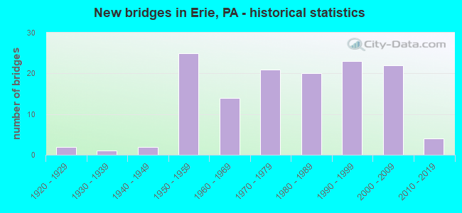
- New bridges - historical statistics
- 21920-1929
- 11930-1939
- 21940-1949
- 251950-1959
- 141960-1969
- 211970-1979
- 201980-1989
- 231990-1999
- 222000-2009
- 42010-2019
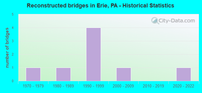
- Reconstructed bridges - Historical Statistics
- 11970-1979
- 11980-1989
- 41990-1999
- 12000-2009
- 02010-2019
- 12020-2022
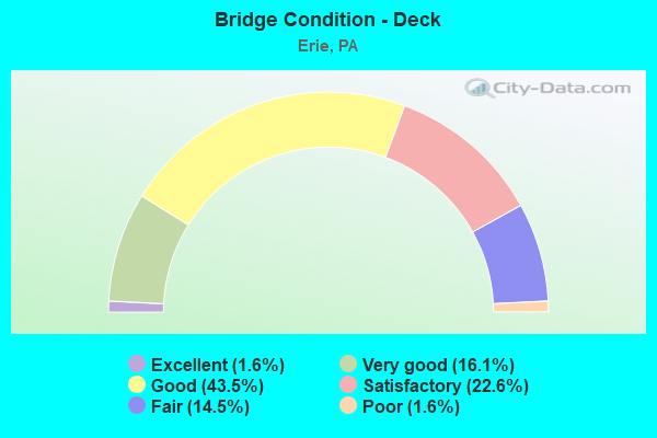
- Bridge Condition - Deck
- 1.6%Excellent
- 16.1%Very good
- 43.5%Good
- 22.6%Satisfactory
- 14.5%Fair
- 1.6%Poor
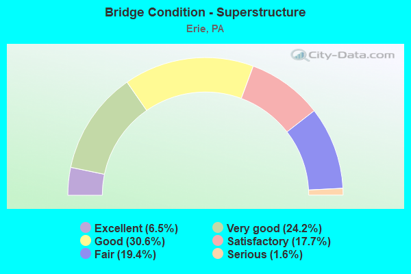
- Bridge Condition - Superstructure
- 6.5%Excellent
- 24.2%Very good
- 30.6%Good
- 17.7%Satisfactory
- 19.4%Fair
- 1.6%Serious
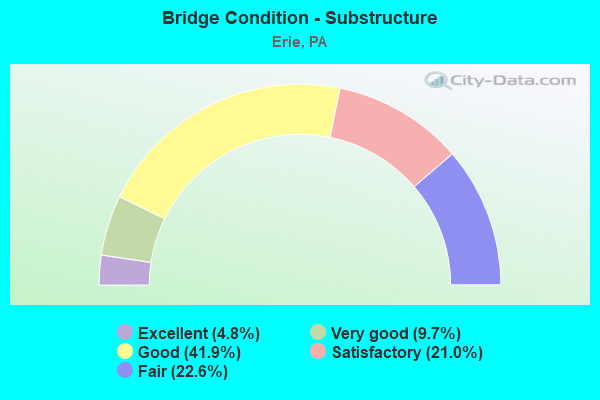
- Bridge Condition - Substructure
- 4.8%Excellent
- 9.7%Very good
- 41.9%Good
- 21.0%Satisfactory
- 22.6%Fair
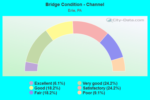
- Bridge Condition - Channel
- 6.1%Excellent
- 24.2%Very good
- 18.2%Good
- 24.2%Satisfactory
- 18.2%Fair
- 9.1%Poor
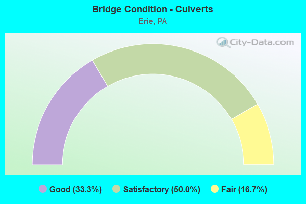
- Bridge Condition - Culverts
- 33.3%Good
- 50.0%Satisfactory
- 16.7%Fair
Find on map >> Show street view
Structure Number: 15908, Location: CITY OF ERIE (Lat: 42.093308, Lng: -80.121150), Route carried "under" structure: Interstate 79, Year Built: 1972, Structure Length: 0. m, Average Daily Traffic: 20,700 (year 2022), Truck Traffic: 4%, Features Intersected: OVER SR 79,NB/SB, Facility Carried by Structure: SR 20 EB,26 TH ST
Minimum Vertical Clearance: 5.16m (16.93ft), Kilometerpoint: 29.763, Lanes on structure: 2, Lanes under structure: 4, Material/Design: Steel continuous, Design/Construction: Stringer/Multi-beam, Length of Maximum Span: 22.3m (73.2ft)
Find on map >> Show street view
Structure Number: 15908, Location: CITY OF ERIE (Lat: 42.093308, Lng: -80.121150), Route carried "under" structure: Interstate 79, Year Built: 1972, Structure Length: 0. m, Average Daily Traffic: 18,576 (year 2022), Truck Traffic: 5%, Features Intersected: OVER SR 79,NB/SB, Facility Carried by Structure: SR 20 EB,26 TH ST
Minimum Vertical Clearance: 5.16m (16.93ft), Kilometerpoint: 29.749, Lanes on structure: 2, Lanes under structure: 4, Material/Design: Steel continuous, Design/Construction: Stringer/Multi-beam, Length of Maximum Span: 22.3m (73.2ft)
Find on map >> Show street view
Structure Number: 15911, Location: CITY OF ERIE (Lat: 42.090000, Lng: -80.121667), Route carried "under" structure: State highway , Year Built: 1972, Structure Length: 0. m, Average Daily Traffic: 8,320 (year 2021), Truck Traffic: 1%, Features Intersected: OVER 4017,PITTSBURG AVE, Facility Carried by Structure: SR 20,W.26TH ST.WB
Minimum Vertical Clearance: 4.55m (14.93ft), Kilometerpoint: 1.236, Lanes on structure: 4, Lanes under structure: 2, Material/Design: Prestressed concrete, Design/Construction: Box Beam or Girders - Single/Spread, Length of Maximum Span: 16.5m (54.1ft)
Find on map >> Show street view
Structure Number: 15912, Location: CITY OF ERIE (Lat: 42.094156, Lng: -80.121750), Route carried "under" structure: Ramp State highway , Year Built: 1972, Structure Length: 0. m, Average Daily Traffic: 3,400 (year 2021), Truck Traffic: 7%, Features Intersected: OVER SR 79,NB/SB RAMP C, Facility Carried by Structure: SR 20 WB,26 TH ST
Minimum Vertical Clearance: 4.45m (14.60ft), Kilometerpoint: 0.000, Lanes on structure: 2, Lanes under structure: 5, Material/Design: Steel continuous, Design/Construction: Stringer/Multi-beam, Length of Maximum Span: 30.8m (101.0ft)
Find on map >> Show street view
Structure Number: 15912, Location: CITY OF ERIE (Lat: 42.094156, Lng: -80.121750), Route carried "under" structure: Interstate 79, Year Built: 1972, Structure Length: 0. m, Average Daily Traffic: 20,700 (year 2022), Truck Traffic: 4%, Features Intersected: OVER SR 79,NB/SB RAMP C, Facility Carried by Structure: SR 20 WB,26 TH ST
Minimum Vertical Clearance: 10.21m (33.50ft), Kilometerpoint: 29.763, Lanes on structure: 2, Lanes under structure: 5, Material/Design: Steel continuous, Design/Construction: Stringer/Multi-beam, Length of Maximum Span: 30.8m (101.0ft)
Find on map >> Show street view
Structure Number: 15912, Location: CITY OF ERIE (Lat: 42.094156, Lng: -80.121750), Route carried "under" structure: Interstate 79, Year Built: 1972, Structure Length: 0. m, Average Daily Traffic: 18,576 (year 2022), Truck Traffic: 5%, Features Intersected: OVER SR 79,NB/SB RAMP C, Facility Carried by Structure: SR 20 WB,26 TH ST
Minimum Vertical Clearance: 10.18m (33.40ft), Kilometerpoint: 29.749, Lanes on structure: 2, Lanes under structure: 5, Material/Design: Steel continuous, Design/Construction: Stringer/Multi-beam, Length of Maximum Span: 30.8m (101.0ft)
Find on map >> Show street view
Structure Number: 15982, Location: CITY OF ERIE (Lat: 42.099286, Lng: -80.121792), Route carried "under" structure: City street W210, Year Built: 1982, Structure Length: 0. m, Average Daily Traffic: 50 (year 2001), Features Intersected: OVER WEST 21ST STREET, Facility Carried by Structure: SR 79,NB
Minimum Vertical Clearance: 5.49m (18.01ft), Kilometerpoint: 0.000, Lanes on structure: 3, Lanes under structure: 2, Material/Design: Prestressed concrete, Design/Construction: Box Beam or Girders - Single/Spread, Length of Maximum Span: 21.3m (69.9ft)
Find on map >> Show street view
Structure Number: 15984, Location: CITY OF ERIE (Lat: 42.099139, Lng: -80.122089), Route carried "under" structure: City street W210, Year Built: 1982, Structure Length: 0. m, Average Daily Traffic: 50 (year 2003), Truck Traffic: 1%, Features Intersected: OVER WEST 21ST STREET, Facility Carried by Structure: SR 79,SB
Minimum Vertical Clearance: 4.78m (15.68ft), Kilometerpoint: 0.000, Lanes on structure: 3, Lanes under structure: 2, Material/Design: Prestressed concrete, Design/Construction: Box Beam or Girders - Single/Spread, Length of Maximum Span: 21.3m (69.9ft)
Find on map >> Show street view
Structure Number: 15986, Location: CITY OF ERIE (Lat: 42.102836, Lng: -80.121925), Route carried "under" structure: City street W160, Year Built: 1983, Structure Length: 0. m, Average Daily Traffic: 50 (year 2001), Features Intersected: OVER W 16TH,CSX &NS RR, Facility Carried by Structure: SR 79,NB
Minimum Vertical Clearance: 7.77m (25.49ft), Kilometerpoint: 0.000, Lanes on structure: 3, Lanes under structure: 2, Material/Design: Steel continuous, Design/Construction: Stringer/Multi-beam, Length of Maximum Span: 68.9m (226.0ft)
Find on map >> Show street view
Structure Number: 1599, Location: CITY OF ERIE (Lat: 42.102622, Lng: -80.122175), Route carried "under" structure: City street W160, Year Built: 1983, Structure Length: 0. m, Average Daily Traffic: 50 (year 2001), Features Intersected: OVER W 16TH,CSX & N&W RR, Facility Carried by Structure: SR 79,SB
Minimum Vertical Clearance: 7.95m (26.08ft), Kilometerpoint: 0.000, Lanes on structure: 3, Lanes under structure: 2, Material/Design: Steel continuous, Design/Construction: Stringer/Multi-beam, Length of Maximum Span: 68.9m (226.0ft)
Find on map >> Show street view
Structure Number: 16051, Location: SUMMIT TOWNSHIP (Lat: 42.042139, Lng: -80.100567), Route carried "under" structure: Interstate 90, Year Built: 1959, Structure Length: 0. m, Average Daily Traffic: 21,995 (year 2021), Truck Traffic: 19%, Features Intersected: OVER SR 90,EB/WB, Facility Carried by Structure: T-534,HAMOT ROAD
Minimum Vertical Clearance: 5.12m (16.80ft), Kilometerpoint: 36.967, Lanes on structure: 2, Lanes under structure: 4, Material/Design: Prestressed concrete, Design/Construction: Box Beam or Girders - Multiple, Length of Maximum Span: 19.5m (64.0ft)
Find on map >> Show street view
Structure Number: 16051, Location: SUMMIT TOWNSHIP (Lat: 42.042139, Lng: -80.100567), Route carried "under" structure: Interstate 90, Year Built: 1959, Structure Length: 0. m, Average Daily Traffic: 23,155 (year 2021), Truck Traffic: 19%, Features Intersected: OVER SR 90,EB/WB, Facility Carried by Structure: T-534,HAMOT ROAD
Minimum Vertical Clearance: 5.07m (16.63ft), Kilometerpoint: 37.033, Lanes on structure: 2, Lanes under structure: 4, Material/Design: Prestressed concrete, Design/Construction: Box Beam or Girders - Multiple, Length of Maximum Span: 19.5m (64.0ft)
Find on map >> Show street view
Structure Number: 16053, Location: SUMMIT TOWNSHIP (Lat: 42.049344, Lng: -80.081278), Route carried "under" structure: US 19, Year Built: 1995, Structure Length: 0. m, Average Daily Traffic: 6,755 (year 2020), Truck Traffic: 7%, Features Intersected: OVER SR 0019, PEACH ST, Facility Carried by Structure: SR 90,EB
Minimum Vertical Clearance: 5.36m (17.59ft), Kilometerpoint: 21.176, Lanes on structure: 2, Lanes under structure: 4, Material/Design: Steel, Design/Construction: Stringer/Multi-beam, Length of Maximum Span: 48.8m (160.1ft)
Find on map >> Show street view
Structure Number: 16054, Location: SUMMIT TOWNSHIP (Lat: 42.049589, Lng: -80.081325), Route carried "under" structure: US 19, Year Built: 1996, Structure Length: 0. m, Average Daily Traffic: 6,755 (year 2020), Truck Traffic: 7%, Features Intersected: OVER SR 0019, PEACH ST, Facility Carried by Structure: SR 90,WB
Minimum Vertical Clearance: 6.22m (20.41ft), Kilometerpoint: 21.176, Lanes on structure: 2, Lanes under structure: 4, Material/Design: Steel, Design/Construction: Stringer/Multi-beam, Length of Maximum Span: 48.8m (160.1ft)
Find on map >> Show street view
Structure Number: 16058, Location: SUMMIT TOWNSHIP (Lat: 42.060881, Lng: -80.056381), Route carried "under" structure: Interstate 90, Year Built: 1959, Structure Length: 0. m, Average Daily Traffic: 27,409 (year 2021), Truck Traffic: 20%, Features Intersected: OVER SR 90,EB/WB, Facility Carried by Structure: T-548,CHERRY ST.
Minimum Vertical Clearance: 4.92m (16.14ft), Kilometerpoint: 41.066, Lanes on structure: 2, Lanes under structure: 4, Material/Design: Prestressed concrete, Design/Construction: Box Beam or Girders - Multiple, Length of Maximum Span: 19.8m (65.0ft)
Find on map >> Show street view
Structure Number: 16058, Location: SUMMIT TOWNSHIP (Lat: 42.060881, Lng: -80.056381), Route carried "under" structure: Interstate 90, Year Built: 1959, Structure Length: 0. m, Average Daily Traffic: 29,584 (year 2021), Truck Traffic: 20%, Features Intersected: OVER SR 90,EB/WB, Facility Carried by Structure: T-548,CHERRY ST.
Minimum Vertical Clearance: 5.25m (17.22ft), Kilometerpoint: 40.966, Lanes on structure: 2, Lanes under structure: 4, Material/Design: Prestressed concrete, Design/Construction: Box Beam or Girders - Multiple, Length of Maximum Span: 19.8m (65.0ft)
Find on map >> Show street view
Structure Number: 16059, Location: SUMMIT TOWNSHIP (Lat: 42.064856, Lng: -80.048978), Route carried "under" structure: City street T558, Year Built: 1995, Structure Length: 0. m, Average Daily Traffic: 50 (year 2001), Features Intersected: OVER T-558,OLD FRENCH RD, Facility Carried by Structure: SR 90,EB
Minimum Vertical Clearance: 4.24m (13.91ft), Kilometerpoint: 0.000, Lanes on structure: 2, Lanes under structure: 2, Material/Design: Prestressed concrete, Design/Construction: Box Beam or Girders - Single/Spread, Length of Maximum Span: 14.9m (48.9ft)
Find on map >> Show street view
Structure Number: 16062, Location: SUMMIT TOWNSHIP (Lat: 42.069814, Lng: -80.039989), Route carried "under" structure: State highway 97, Year Built: 1959, Structure Length: 0. m, Average Daily Traffic: 7,295 (year 2011), Truck Traffic: 3%, Features Intersected: OVER SR 97,UNION CITY RD, Facility Carried by Structure: SR 90,EB
Minimum Vertical Clearance: 5.39m (17.68ft), Kilometerpoint: 25.669, Lanes on structure: 2, Lanes under structure: 4, Material/Design: Prestressed concrete, Design/Construction: Box Beam or Girders - Multiple, Length of Maximum Span: 21.9m (71.9ft)
Find on map >> Show street view
Structure Number: 16062, Location: SUMMIT TOWNSHIP (Lat: 42.069814, Lng: -80.039989), Route carried "under" structure: State highway 97, Year Built: 1959, Structure Length: 0. m, Average Daily Traffic: 14,806 (year 2022), Truck Traffic: 4%, Features Intersected: OVER SR 97,UNION CITY RD, Facility Carried by Structure: SR 90,EB
Minimum Vertical Clearance: 5.39m (17.68ft), Kilometerpoint: 26.147, Lanes on structure: 2, Lanes under structure: 4, Material/Design: Prestressed concrete, Design/Construction: Box Beam or Girders - Multiple, Length of Maximum Span: 21.9m (71.9ft)
Find on map >> Show street view
Structure Number: 16063, Location: SUMMIT TOWNSHIP (Lat: 42.070006, Lng: -80.040167), Route carried "under" structure: State highway 97, Year Built: 1959, Structure Length: 0. m, Average Daily Traffic: 7,295 (year 2011), Truck Traffic: 3%, Features Intersected: OVER SR 97,UNION CITY RD, Facility Carried by Structure: SR 90,WB
Minimum Vertical Clearance: 4.57m (14.99ft), Kilometerpoint: 25.669, Lanes on structure: 2, Lanes under structure: 4, Material/Design: Prestressed concrete, Design/Construction: Box Beam or Girders - Multiple, Length of Maximum Span: 21.9m (71.9ft)
Find on map >> Show street view
Structure Number: 16063, Location: SUMMIT TOWNSHIP (Lat: 42.070006, Lng: -80.040167), Route carried "under" structure: State highway 97, Year Built: 1959, Structure Length: 0. m, Average Daily Traffic: 14,806 (year 2022), Truck Traffic: 4%, Features Intersected: OVER SR 97,UNION CITY RD, Facility Carried by Structure: SR 90,WB
Minimum Vertical Clearance: 4.50m (14.76ft), Kilometerpoint: 26.147, Lanes on structure: 2, Lanes under structure: 4, Material/Design: Prestressed concrete, Design/Construction: Box Beam or Girders - Multiple, Length of Maximum Span: 21.9m (71.9ft)
Find on map >> Show street view
Structure Number: 16067, Location: SUMMIT TOWNSHIP (Lat: 42.074947, Lng: -80.032222), Route carried "under" structure: City street T568, Year Built: 1996, Structure Length: 0. m, Average Daily Traffic: 50 (year 2002), Features Intersected: OVER T-568,FOOTMILL ROAD, Facility Carried by Structure: SR 90,WB
Minimum Vertical Clearance: 4.52m (14.83ft), Kilometerpoint: 0.000, Lanes on structure: 2, Lanes under structure: 2, Material/Design: Prestressed concrete continuous, Design/Construction: Box Beam or Girders - Multiple, Length of Maximum Span: 10.7m (35.1ft)
Find on map >> Show street view
Structure Number: 16071, Location: MILL CREEK TOWNSHIP (Lat: 42.093311, Lng: -80.005831), Route carried "under" structure: State highway 8, Year Built: 1959, Structure Length: 0. m, Average Daily Traffic: 3,882 (year 2021), Truck Traffic: 5%, Features Intersected: OVER SR 8,WATTSBURG ROAD, Facility Carried by Structure: SR 90,EB
Minimum Vertical Clearance: 4.36m (14.30ft), Kilometerpoint: 40.496, Lanes on structure: 3, Lanes under structure: 3, Material/Design: Prestressed concrete, Design/Construction: Box Beam or Girders - Multiple, Length of Maximum Span: 21.9m (71.9ft)
Find on map >> Show street view
Structure Number: 16071, Location: MILL CREEK TOWNSHIP (Lat: 42.093311, Lng: -80.005831), Route carried "under" structure: State highway 8, Year Built: 1959, Structure Length: 0. m, Average Daily Traffic: 3,341 (year 2022), Truck Traffic: 9%, Features Intersected: OVER SR 8,WATTSBURG ROAD, Facility Carried by Structure: SR 90,EB
Minimum Vertical Clearance: 4.38m (14.37ft), Kilometerpoint: 40.496, Lanes on structure: 3, Lanes under structure: 3, Material/Design: Prestressed concrete, Design/Construction: Box Beam or Girders - Multiple, Length of Maximum Span: 21.9m (71.9ft)
Find on map >> Show street view
Structure Number: 16073, Location: MILL CREEK TOWNSHIP (Lat: 42.093481, Lng: -80.006072), Route carried "under" structure: State highway 8, Year Built: 1959, Structure Length: 0. m, Average Daily Traffic: 3,341 (year 2022), Truck Traffic: 9%, Features Intersected: OVER SR 8,WATTSBURG ROAD, Facility Carried by Structure: SR 90,WB
Minimum Vertical Clearance: 4.52m (14.83ft), Kilometerpoint: 40.496, Lanes on structure: 2, Lanes under structure: 3, Material/Design: Prestressed concrete, Design/Construction: Box Beam or Girders - Multiple, Length of Maximum Span: 21.9m (71.9ft)
Find on map >> Show street view
Structure Number: 16073, Location: MILL CREEK TOWNSHIP (Lat: 42.093481, Lng: -80.006072), Route carried "under" structure: State highway 8, Year Built: 1959, Structure Length: 0. m, Average Daily Traffic: 3,882 (year 2021), Truck Traffic: 5%, Features Intersected: OVER SR 8,WATTSBURG ROAD, Facility Carried by Structure: SR 90,WB
Minimum Vertical Clearance: 4.50m (14.76ft), Kilometerpoint: 40.496, Lanes on structure: 2, Lanes under structure: 3, Material/Design: Prestressed concrete, Design/Construction: Box Beam or Girders - Multiple, Length of Maximum Span: 21.9m (71.9ft)
Find on map >> Show street view
Structure Number: 16367, Location: SUMMIT TOWNSHIP (Lat: 42.045369, Lng: -80.115844), Route carried "under" structure: Interstate 79, Year Built: 1965, Structure Length: 0. m, Average Daily Traffic: 10,867 (year 2021), Truck Traffic: 8%, Features Intersected: OVER SR 79,NB/SB, Facility Carried by Structure: SR 4010,HERSHEY RD
Minimum Vertical Clearance: 5.18m (16.99ft), Kilometerpoint: 23.987, Lanes on structure: 2, Lanes under structure: 4, Material/Design: Prestressed concrete, Design/Construction: Box Beam or Girders - Single/Spread, Length of Maximum Span: 22.6m (74.1ft)
Find on map >> Show street view
Structure Number: 16367, Location: SUMMIT TOWNSHIP (Lat: 42.045369, Lng: -80.115844), Route carried "under" structure: Interstate 79, Year Built: 1965, Structure Length: 0. m, Average Daily Traffic: 11,597 (year 2021), Truck Traffic: 7%, Features Intersected: OVER SR 79,NB/SB, Facility Carried by Structure: SR 4010,HERSHEY RD
Minimum Vertical Clearance: 5.36m (17.59ft), Kilometerpoint: 23.973, Lanes on structure: 2, Lanes under structure: 4, Material/Design: Prestressed concrete, Design/Construction: Box Beam or Girders - Single/Spread, Length of Maximum Span: 22.6m (74.1ft)
Find on map >> Show street view
Structure Number: 16375, Location: MILL CREEK TOWNSHIP (Lat: 42.065883, Lng: -80.105931), Route carried "under" structure: Interstate 79, Year Built: 1965, Structure Length: 0. m, Average Daily Traffic: 15,393 (year 2021), Truck Traffic: 5%, Features Intersected: OVER SR 79,NB/SB, Facility Carried by Structure: SR 4012,ZIMMERLY R
Minimum Vertical Clearance: 5.46m (17.91ft), Kilometerpoint: 25.727, Lanes on structure: 4, Lanes under structure: 4, Material/Design: Prestressed concrete, Design/Construction: Box Beam or Girders - Single/Spread, Length of Maximum Span: 17.7m (58.1ft)
Find on map >> Show street view
Structure Number: 16375, Location: MILL CREEK TOWNSHIP (Lat: 42.065883, Lng: -80.105931), Route carried "under" structure: Interstate 79, Year Built: 1965, Structure Length: 0. m, Average Daily Traffic: 15,192 (year 2021), Truck Traffic: 5%, Features Intersected: OVER SR 79,NB/SB, Facility Carried by Structure: SR 4012,ZIMMERLY R
Minimum Vertical Clearance: 5.49m (18.01ft), Kilometerpoint: 25.745, Lanes on structure: 4, Lanes under structure: 4, Material/Design: Prestressed concrete, Design/Construction: Box Beam or Girders - Single/Spread, Length of Maximum Span: 17.7m (58.1ft)
Find on map >> Show street view
Structure Number: 16383, Location: CITY OF ERIE (Lat: 42.077706, Lng: -80.110908), Route carried "under" structure: Interstate 79, Year Built: 1965, Structure Length: 0. m, Average Daily Traffic: 15,393 (year 2021), Truck Traffic: 5%, Features Intersected: OVER SR 79,NB/SB, Facility Carried by Structure: SR 4014,W GRNDVIEW
Minimum Vertical Clearance: 5.26m (17.26ft), Kilometerpoint: 27.336, Lanes on structure: 2, Lanes under structure: 4, Material/Design: Prestressed concrete, Design/Construction: Box Beam or Girders - Single/Spread, Length of Maximum Span: 17.7m (58.1ft)
Find on map >> Show street view
Structure Number: 16383, Location: CITY OF ERIE (Lat: 42.077706, Lng: -80.110908), Route carried "under" structure: Interstate 79, Year Built: 1965, Structure Length: 0. m, Average Daily Traffic: 15,192 (year 2021), Truck Traffic: 5%, Features Intersected: OVER SR 79,NB/SB, Facility Carried by Structure: SR 4014,W GRNDVIEW
Minimum Vertical Clearance: 5.16m (16.93ft), Kilometerpoint: 27.386, Lanes on structure: 2, Lanes under structure: 4, Material/Design: Prestressed concrete, Design/Construction: Box Beam or Girders - Single/Spread, Length of Maximum Span: 17.7m (58.1ft)
Find on map >> Show street view
Structure Number: 16385, Location: CITY OF ERIE (Lat: 42.084244, Lng: -80.115025), Route carried "under" structure: Interstate 79, Year Built: 1965, Structure Length: 0. m, Average Daily Traffic: 15,393 (year 2021), Truck Traffic: 5%, Features Intersected: OVER SR 79,NB/SB, Facility Carried by Structure: SR 4016,38TH ST
Minimum Vertical Clearance: 5.18m (16.99ft), Kilometerpoint: 28.147, Lanes on structure: 4, Lanes under structure: 4, Material/Design: Prestressed concrete, Design/Construction: Box Beam or Girders - Single/Spread, Length of Maximum Span: 16.5m (54.1ft)
Find on map >> Show street view
Structure Number: 16385, Location: CITY OF ERIE (Lat: 42.084244, Lng: -80.115025), Route carried "under" structure: Interstate 79, Year Built: 1965, Structure Length: 0. m, Average Daily Traffic: 15,192 (year 2021), Truck Traffic: 5%, Features Intersected: OVER SR 79,NB/SB, Facility Carried by Structure: SR 4016,38TH ST
Minimum Vertical Clearance: 5.16m (16.93ft), Kilometerpoint: 28.147, Lanes on structure: 4, Lanes under structure: 4, Material/Design: Prestressed concrete, Design/Construction: Box Beam or Girders - Single/Spread, Length of Maximum Span: 16.5m (54.1ft)
Find on map >> Show street view
Structure Number: 16507, Location: 500FT SW of Penn. Ave. (Lat: 42.125300, Lng: -80.053100), Route carried "under" structure: State highway 290, Year Built: 2004, Structure Length: 0. m, Average Daily Traffic: 6,892 (year 2022), Truck Traffic: 3%, Features Intersected: OVER NSRC & SR 0290, Facility Carried by Structure: BUFFALO ROAD
Minimum Vertical Clearance: 5.26m (17.26ft), Kilometerpoint: 0.930, Lanes on structure: 2, Lanes under structure: 4, Material/Design: Prestressed concrete, Design/Construction: Box Beam or Girders - Single/Spread, Length of Maximum Span: 38.7m (127.0ft)
Find on map >> Show street view
Structure Number: 16507, Location: 500FT SW of Penn. Ave. (Lat: 42.125300, Lng: -80.053100), Route carried "under" structure: State highway 290, Year Built: 2004, Structure Length: 0. m, Average Daily Traffic: 6,612 (year 2022), Truck Traffic: 3%, Features Intersected: OVER NSRC & SR 0290, Facility Carried by Structure: BUFFALO ROAD
Minimum Vertical Clearance: 5.26m (17.26ft), Kilometerpoint: 0.922, Lanes on structure: 2, Lanes under structure: 4, Material/Design: Prestressed concrete, Design/Construction: Box Beam or Girders - Single/Spread, Length of Maximum Span: 38.7m (127.0ft)
Find on map >> Show street view
Structure Number: 16509, Location: 200 FT.S.OF E. 12TH ST. (Lat: 42.138597, Lng: -80.031675), Route carried "under" structure: City street E016, Year Built: 1943, Structure Length: 0. m, Average Daily Traffic: 250 (year 2004), Features Intersected: OVER BNSF & CSX RR, Facility Carried by Structure: FRANKLIN AVENUE
Minimum Vertical Clearance: 8.84m (29.00ft), Kilometerpoint: 0.000, Lanes on structure: 2, Lanes under structure: 2, Material/Design: Prestressed concrete continuous, Design/Construction: Box Beam or Girders - Single/Spread, Length of Maximum Span: 25.0m (82.0ft)
Find on map >> Show street view
Structure Number: 16529, Location: CITY OF ERIE (Lat: 42.093803, Lng: -80.121797), Route carried "under" structure: Interstate 79, Year Built: 1972, Structure Length: 0. m, Average Daily Traffic: 20,700 (year 2022), Truck Traffic: 4%, Features Intersected: OVER SR 20,RAMP C,SR 79
Minimum Vertical Clearance: 13.72m (45.01ft), Kilometerpoint: 29.763, Lanes on structure: 1, Lanes under structure: 7, Material/Design: Steel continuous, Design/Construction: Stringer/Multi-beam, Length of Maximum Span: 32.9m (107.9ft)
Find on map >> Show street view
Structure Number: 16529, Location: CITY OF ERIE (Lat: 42.093803, Lng: -80.121797), Route carried "under" structure: Ramp State highway , Year Built: 1972, Structure Length: 0. m, Average Daily Traffic: 3,400 (year 2021), Truck Traffic: 7%, Features Intersected: OVER SR 20,RAMP C,SR 79, Facility Carried by Structure: RAMP B FROM SR 79
Minimum Vertical Clearance: 4.53m (14.86ft), Kilometerpoint: 0.000, Lanes on structure: 1, Lanes under structure: 7, Material/Design: Steel continuous, Design/Construction: Stringer/Multi-beam, Length of Maximum Span: 32.9m (107.9ft)
Find on map >> Show street view
Structure Number: 16529, Location: CITY OF ERIE (Lat: 42.093803, Lng: -80.121797), Route carried "under" structure: US 20, Year Built: 1972, Structure Length: 0. m, Average Daily Traffic: 6,992 (year 2022), Truck Traffic: 3%, Features Intersected: OVER SR 20,RAMP C,SR 79, Facility Carried by Structure: RAMP B FROM SR 79
Minimum Vertical Clearance: 4.80m (15.75ft), Kilometerpoint: 37.480, Lanes on structure: 1, Lanes under structure: 7, Material/Design: Steel continuous, Design/Construction: Stringer/Multi-beam, Length of Maximum Span: 32.9m (107.9ft)
Find on map >> Show street view
Structure Number: 16529, Location: CITY OF ERIE (Lat: 42.093803, Lng: -80.121797), Route carried "under" structure: Interstate 79, Year Built: 1972, Structure Length: 0. m, Average Daily Traffic: 18,576 (year 2022), Truck Traffic: 5%, Features Intersected: OVER SR 20,RAMP C,SR 79
Minimum Vertical Clearance: 10.67m (35.01ft), Kilometerpoint: 29.749, Lanes on structure: 1, Lanes under structure: 7, Material/Design: Steel continuous, Design/Construction: Stringer/Multi-beam, Length of Maximum Span: 32.9m (107.9ft)
Find on map >> Show street view
Structure Number: 1653, Location: CITY OF ERIE (Lat: 42.093556, Lng: -80.121467), Route carried "under" structure: Interstate 79, Year Built: 1972, Structure Length: 0. m, Average Daily Traffic: 20,700 (year 2022), Truck Traffic: 4%, Features Intersected: OVER SR 79,N.B & S.B., Facility Carried by Structure: RAMP C FROM SR 20
Minimum Vertical Clearance: 4.95m (16.24ft), Kilometerpoint: 29.763, Lanes on structure: 1, Lanes under structure: 4, Material/Design: Steel continuous, Design/Construction: Stringer/Multi-beam, Length of Maximum Span: 32.9m (107.9ft)
Find on map >> Show street view
Structure Number: 1653, Location: CITY OF ERIE (Lat: 42.093556, Lng: -80.121467), Route carried "under" structure: Interstate 79, Year Built: 1972, Structure Length: 0. m, Average Daily Traffic: 18,576 (year 2022), Truck Traffic: 5%, Features Intersected: OVER SR 79,N.B & S.B., Facility Carried by Structure: RAMP C FROM SR 20
Minimum Vertical Clearance: 5.11m (16.77ft), Kilometerpoint: 29.749, Lanes on structure: 1, Lanes under structure: 4, Material/Design: Steel continuous, Design/Construction: Stringer/Multi-beam, Length of Maximum Span: 32.9m (107.9ft)
Find on map >> Show street view
Structure Number: 39534, Location: SUMMIT TOWNSHIP (Lat: 42.065122, Lng: -80.048989), Route carried "under" structure: City street T558, Year Built: 1996, Structure Length: 0. m, Average Daily Traffic: 50 (year 2001), Features Intersected: OVER T-558,OLD FRENCH RD, Facility Carried by Structure: SR 90,WB
Minimum Vertical Clearance: 5.76m (18.90ft), Kilometerpoint: 0.000, Lanes on structure: 2, Lanes under structure: 2, Material/Design: Prestressed concrete, Design/Construction: Box Beam or Girders - Single/Spread, Length of Maximum Span: 14.3m (46.9ft)
Find on map >> Show street view
Structure Number: 3959, Location: SUMMIT TOWNSHIP (Lat: 42.074733, Lng: -80.032056), Route carried "under" structure: City street T568, Year Built: 1997, Structure Length: 0. m, Average Daily Traffic: 50 (year 2002), Features Intersected: OVER T-568,FOOTMILL ROAD, Facility Carried by Structure: SR 90,EB
Minimum Vertical Clearance: 4.52m (14.83ft), Kilometerpoint: 0.000, Lanes on structure: 2, Lanes under structure: 2, Material/Design: Prestressed concrete continuous, Design/Construction: Box Beam or Girders - Multiple, Length of Maximum Span: 10.7m (35.1ft)
Find on map >> Show street view
Structure Number: 4083, Location: CITY OF ERIE (Lat: 42.119506, Lng: -80.114236), Route carried "under" structure: State highway , Year Built: 1998, Structure Length: 0. m, Average Daily Traffic: 13,002 (year 2020), Truck Traffic: 4%, Features Intersected: OVER SR 4034, Facility Carried by Structure: WEST 6TH STREET
Minimum Vertical Clearance: 5.16m (16.93ft), Kilometerpoint: 1.078, Lanes on structure: 2, Lanes under structure: 3, Material/Design: Steel continuous, Design/Construction: Stringer/Multi-beam, Length of Maximum Span: 38.1m (125.0ft)
Find on map >> Show street view
Structure Number: 40919, Location: CITY OF ERIE (Lat: 42.089244, Lng: -80.118483), Route carried "under" structure: City street 320T, Year Built: 2000, Structure Length: 0. m, Average Daily Traffic: 100 (year 2002), Truck Traffic: 4%, Features Intersected: OVER WEST 32ND STREET, Facility Carried by Structure: SR 79,NB
Minimum Vertical Clearance: 4.47m (14.67ft), Kilometerpoint: 0.000, Lanes on structure: 3, Lanes under structure: 2, Material/Design: Prestressed concrete, Design/Construction: Box Beam or Girders - Multiple, Length of Maximum Span: 30.2m (99.1ft)
Find on map >> Show street view
Structure Number: 41231, Location: CITY OF ERIE (Lat: 42.089175, Lng: -80.118694), Route carried "under" structure: City street 320T, Year Built: 2001, Structure Length: 0. m, Average Daily Traffic: 100 (year 2002), Truck Traffic: 4%, Features Intersected: OVER WEST 32ND STREET, Facility Carried by Structure: SR 79,SB
Minimum Vertical Clearance: 4.52m (14.83ft), Kilometerpoint: 0.000, Lanes on structure: 2, Lanes under structure: 2, Material/Design: Prestressed concrete, Design/Construction: Box Beam or Girders - Multiple, Length of Maximum Span: 30.8m (101.0ft)
Find on map >> Show street view
Structure Number: 42021, Location: GREEN TOWNSHIP (Lat: 42.082283, Lng: -80.021969), Route carried "under" structure: Interstate 90, Year Built: 2003, Structure Length: 0. m, Average Daily Traffic: 23,543 (year 2021), Truck Traffic: 17%, Features Intersected: OVER SR 90,EB/WB, Facility Carried by Structure: SR 1001,LK.PLSNT.R
Minimum Vertical Clearance: 5.35m (17.55ft), Kilometerpoint: 45.099, Lanes on structure: 2, Lanes under structure: 4, Material/Design: Prestressed concrete continuous, Design/Construction: Box Beam or Girders - Multiple, Length of Maximum Span: 27.1m (88.9ft)
Find on map >> Show street view
Structure Number: 42021, Location: GREEN TOWNSHIP (Lat: 42.082283, Lng: -80.021969), Route carried "under" structure: Interstate 90, Year Built: 2003, Structure Length: 0. m, Average Daily Traffic: 24,493 (year 2021), Truck Traffic: 17%, Features Intersected: OVER SR 90,EB/WB, Facility Carried by Structure: SR 1001,LK.PLSNT.R
Minimum Vertical Clearance: 4.91m (16.11ft), Kilometerpoint: 45.021, Lanes on structure: 2, Lanes under structure: 4, Material/Design: Prestressed concrete continuous, Design/Construction: Box Beam or Girders - Multiple, Length of Maximum Span: 27.1m (88.9ft)
Find on map >> Show street view
Structure Number: 42589, Location: CITY ERIE (Lat: 42.123967, Lng: -80.043075), Route carried "under" structure: US 20, Year Built: 2004, Structure Length: 0. m, Average Daily Traffic: 3,417 (year 2020), Truck Traffic: 3%, Features Intersected: BROAD ST./S.R.20, Facility Carried by Structure: EAST ACCESS HWY.
Minimum Vertical Clearance: 5.40m (17.72ft), Kilometerpoint: 45.334, Lanes on structure: 4, Lanes under structure: 4, Material/Design: Prestressed concrete, Design/Construction: Box Beam or Girders - Single/Spread, Length of Maximum Span: 25.3m (83.0ft)
Find on map >> Show street view
Structure Number: 42589, Location: CITY ERIE (Lat: 42.123967, Lng: -80.043075), Route carried "under" structure: US 20, Year Built: 2004, Structure Length: 0. m, Average Daily Traffic: 3,209 (year 2020), Truck Traffic: 4%, Features Intersected: BROAD ST./S.R.20, Facility Carried by Structure: EAST ACCESS HWY.
Minimum Vertical Clearance: 5.40m (17.72ft), Kilometerpoint: 45.334, Lanes on structure: 4, Lanes under structure: 4, Material/Design: Prestressed concrete, Design/Construction: Box Beam or Girders - Single/Spread, Length of Maximum Span: 25.3m (83.0ft)