Bridge Statistics for Flint, Michigan (MI)
Condition, Traffic, Stress, Structural Evaluation, Project Costs
- National Bridge Inventory (NBI) Statistics
- 266Number of bridges
- 2,680ft / 817mTotal length
- $9,644,000Total costs
- 7,390,893Total average daily traffic
- 449,050Total average daily truck traffic
- National Bridge Inventory (NBI) Registered Bridges for Flint
- No street view available for this location
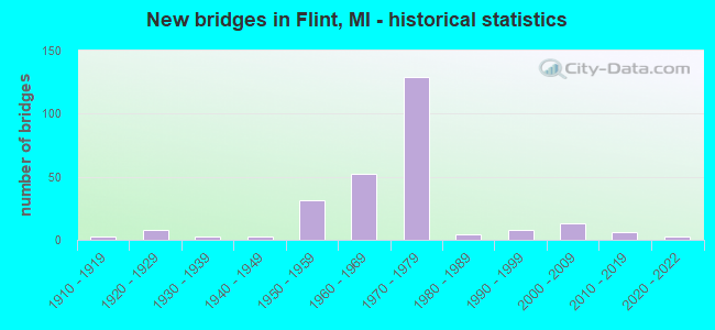
- New bridges - historical statistics
- 11900-1909
- 31910-1919
- 81920-1929
- 31930-1939
- 31940-1949
- 311950-1959
- 521960-1969
- 1291970-1979
- 41980-1989
- 81990-1999
- 132000-2009
- 62010-2019
- 32020-2022
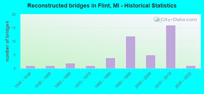
- Reconstructed bridges - Historical Statistics
- 11940-1949
- 11950-1959
- 21960-1969
- 11970-1979
- 41980-1989
- 121990-1999
- 52000-2009
- 162010-2019
- 12020-2022
- Bridge Condition - Deck
- 2.0%Excellent
- 8.6%Very good
- 17.8%Good
- 31.6%Satisfactory
- 26.3%Fair
- 8.6%Poor
- 4.6%Serious
- 0.7%Critical
- Bridge Condition - Superstructure
- 1.3%Excellent
- 13.1%Very good
- 19.0%Good
- 28.1%Satisfactory
- 27.5%Fair
- 6.5%Poor
- 3.9%Serious
- 0.7%Critical
- Bridge Condition - Substructure
- 7.8%Excellent
- 30.1%Very good
- 37.9%Good
- 19.0%Satisfactory
- 3.3%Fair
- 2.0%Poor
- 0.7%Serious
- 0.7%Critical
- Bridge Condition - Channel
- 10.3%Very good
- 42.3%Good
- 25.6%Satisfactory
- 17.9%Fair
- 3.8%Poor
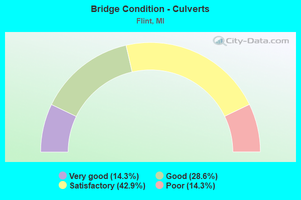
- Bridge Condition - Culverts
- 14.3%Very good
- 28.6%Good
- 42.9%Satisfactory
- 14.3%Poor
Find on map >> Show street view
Structure Number: 2608, Location: IN FLINT (Lat: 43.008547, Lng: -83.683600), Route carried "on" structure: City street , Year Built: 1970, Status: Open, Structure Length: 8.35m (27.40ft), Average Daily Traffic: 14,650 (year 2011), Truck Traffic: 4%, Average Future Daily Traffic: 16,200 (year 2031), Design Load: HS 20, Features Intersected: I-69, Facility Carried by Structure: SAGINAW ST
Minimum Vertical Clearance: 30.48m (100.00ft), Kilometerpoint: 17.460, Lanes on structure: 4, Lanes under structure: 10, Base Highway Network: Yes (Inventory Route: 149, Subroute: 2), Owner: State Highway Agency, Approaching Roadway Width: 17.9m (58.7ft), Material/Design: Steel, Design/Construction: Stringer/Multi-beam, Number Of Spans In Main Unit: 2, Length of Maximum Span: 43.0m (141.1ft), Curb or Sidewalk Widths: Left: 1.8m (5.9ft), Right: 1.8m (5.9ft), Curb-To-Curb Width: 18.0m (59.1ft), Out-to-Out Width: 22.4m (73.5ft)
Condition: Deck: Satisfactory, Superstructure: Fair, Substructure: Satisfactory, Operating Rating: 75.8 metric tons, Method Used To Determine Operating Rating: Load Factor (LF) rating reported by rating factor (RF) method using MS18 loading, Inventory Rating: 45.4 metric tons, Method Used To Determine Inventory Rating: Load Factor (LF) rating reported by rating factor (RF) method using MS18 loading, Structural Evaluation: Somewhat better than minimum adequacy, Deck Geometry: Somewhat better than minimum adequacy, Underclear: High priority of corrective action, Approach Roadway Alignment: Equal to present desirable criteria, Designated Inspection Frequency: Every 24 months, Inspection Date: January 2022, Deck Structure Type: Concrete Cast-file-Place, Wearing Surface/Protective System: Wearing Surface: Epoxy Overlay
Find on map >> Show street view
Structure Number: 2632, Location: 1.2 MI SE OF US-23 (Lat: 42.944192, Lng: -83.712939), Route carried "on" structure: County highway 2002, Year Built: 1962, Year Reconstructed: 2002, Status: Open, Structure Length: 8.73m (28.64ft), Average Daily Traffic: 25,344 (year 1996), Truck Traffic: 3%, Average Future Daily Traffic: 45,770 (year 2016), Design Load: H 20, Features Intersected: I-75, Facility Carried by Structure: HILL RD
Minimum Vertical Clearance: 30.48m (100.00ft), Kilometerpoint: 11.898, Lanes on structure: 4, Lanes under structure: 6, Base Highway Network: Yes (Inventory Route: 151, Subroute: 9), Owner: State Highway Agency, Approaching Roadway Width: 17.4m (57.1ft), Skew: 4 degrees, Material/Design: Prestressed concrete, Design/Construction: Box Beam or Girders - Single/Spread, Number Of Spans In Main Unit: 4, Length of Maximum Span: 29.8m (97.8ft), Curb-To-Curb Width: 15.8m (51.8ft), Out-to-Out Width: 16.8m (55.1ft)
Condition: Deck: Fair, Superstructure: Satisfactory, Substructure: Satisfactory, Operating Rating: 77.4 metric tons, Method Used To Determine Operating Rating: Load Factor (LF) rating reported by rating factor (RF) method using MS18 loading, Inventory Rating: 27.9 metric tons, Method Used To Determine Inventory Rating: Load Factor (LF) rating reported by rating factor (RF) method using MS18 loading, Structural Evaluation: Equal to present minimum criteria, Deck Geometry: Meets minimum limits, Underclear: Somewhat better than minimum adequacy, Approach Roadway Alignment: Equal to present desirable criteria, Designated Inspection Frequency: Every 13 months, Inspection Date: May 2021, Deck Structure Type: Concrete Cast-file-Place, Wearing Surface/Protective System: Wearing Surface: Monolithic Concrete, Deck Protection: Epoxy Coated Reinforcing
Find on map >> Show street view
Structure Number: 2633, Location: 1.6 MI SE OF M-121 (Lat: 42.951428, Lng: -83.722958), Route carried "on" structure: Interstate 75, Year Built: 1962, Year Reconstructed: 1980, Status: Open, Structure Length: 7.40m (24.28ft), Average Daily Traffic: 17,100 (year 2007), Truck Traffic: 9%, Average Future Daily Traffic: 21,400 (year 2018), Design Load: HS 20, Features Intersected: US-23 NB
Minimum Vertical Clearance: 30.48m (100.00ft), Kilometerpoint: 13.598, Lanes on structure: 2, Lanes under structure: 3, Base Highway Network: Yes (Inventory Route: 150, Subroute: 7), Owner: State Highway Agency, Approaching Roadway Width: 13.7m (44.9ft), Skew: 5 degrees, Material/Design: Steel, Design/Construction: Stringer/Multi-beam, Number Of Spans In Main Unit: 3, Length of Maximum Span: 35.6m (116.8ft), Curb-To-Curb Width: 9.8m (32.2ft), Out-to-Out Width: 11.1m (36.4ft)
Condition: Deck: Fair, Superstructure: Satisfactory, Substructure: Satisfactory, Operating Rating: 68.0 metric tons, Method Used To Determine Operating Rating: Load Factor (LF) rating reported by rating factor (RF) method using MS18 loading, Inventory Rating: 40.8 metric tons, Method Used To Determine Inventory Rating: Load Factor (LF) rating reported by rating factor (RF) method using MS18 loading, Structural Evaluation: Equal to present minimum criteria, Deck Geometry: Meets minimum limits, Underclear: Meets minimum limits, Approach Roadway Alignment: Equal to present desirable criteria, Designated Inspection Frequency: Every 10 months, Inspection Date: May 2021, Deck Structure Type: Concrete Cast-file-Place, Wearing Surface/Protective System: Wearing Surface: Latex Concrete
Find on map >> Show street view
Structure Number: 2636, Location: IN FLINT (Lat: 43.003503, Lng: -83.676378), Route carried "on" structure: Interstate 475, Year Built: 1971, Status: Open, Structure Length: 1.22m (4.00ft), Average Daily Traffic: 59,000 (year 2007), Truck Traffic: 4%, Average Future Daily Traffic: 58,830 (year 2018), Design Load: HS 20+Mod, Features Intersected: THREAD CREEK
Minimum Vertical Clearance: 30.48m (100.00ft), Kilometerpoint: 9.615, Lanes on structure: 7, Base Highway Network: Yes (Inventory Route: 149, Subroute: 3), Owner: State Highway Agency, Approaching Roadway Width: 39.9m (130.9ft), Skew: 31 degrees, Material/Design: Steel, Design/Construction: Stringer/Multi-beam, Number Of Spans In Main Unit: 1, Length of Maximum Span: 12.2m (40.0ft), Curb or Sidewalk Widths: Left: 0.2m (0.7ft), Right: 0.2m (0.7ft), Curb-To-Curb Width: 38.7m (127.0ft), Out-to-Out Width: 39.3m (128.9ft)
Condition: Deck: Fair, Superstructure: Satisfactory, Substructure: Satisfactory, Channel: Good, Operating Rating: 57.0 metric tons, Method Used To Determine Operating Rating: Load Factor (LF) rating reported by rating factor (RF) method using MS18 loading, Inventory Rating: 34.3 metric tons, Method Used To Determine Inventory Rating: Load Factor (LF) rating reported by rating factor (RF) method using MS18 loading, Structural Evaluation: Equal to present minimum criteria, Deck Geometry: Superior to present desirable criteria, Waterway Adequacy: Equal to present desirable criteria, Approach Roadway Alignment: Equal to present desirable criteria, Designated Inspection Frequency: Every 24 months, Inspection Date: June 2020, Deck Structure Type: Concrete Cast-file-Place, Wearing Surface/Protective System: Wearing Surface: Monolithic Concrete
Find on map >> Show street view
Structure Number: 2637, Location: IN FLINT (Lat: 43.038486, Lng: -83.676839), Route carried "on" structure: Interstate 475, Year Built: 1976, Status: Temporarily open, Structure Length: 16.15m (52.99ft), Average Daily Traffic: 56,000 (year 2007), Truck Traffic: 3%, Average Future Daily Traffic: 66,597 (year 2018), Design Load: HS 25 or greater, Features Intersected: FLINT R,W BLVD&R SIDE DR
Minimum Vertical Clearance: 30.48m (100.00ft), Kilometerpoint: 13.878, Lanes on structure: 6, Lanes under structure: 4, Base Highway Network: Yes (Inventory Route: 149, Subroute: 3), Owner: State Highway Agency, Approaching Roadway Width: 36.5m (119.8ft), Skew: 35 degrees, Material/Design: Steel, Design/Construction: Stringer/Multi-beam, Number Of Spans In Main Unit: 6, Length of Maximum Span: 37.5m (123.0ft), Curb-To-Curb Width: 37.2m (122.0ft), Out-to-Out Width: 38.0m (124.7ft)
Condition: Deck: Fair, Superstructure: Satisfactory, Substructure: Fair, Channel: Satisfactory, Structural Evaluation: High priority of corrective action, Deck Geometry: Superior to present desirable criteria, Underclear: Somewhat better than minimum adequacy, Waterway Adequacy: Equal to present desirable criteria, Approach Roadway Alignment: Equal to present desirable criteria, Length Of Structure Improvement: 16.16m (53.02ft), Designated Inspection Frequency: Every 24 months, Underwater Inspection Frequency: Every 60 months, Other Special Inspection Frequency: Every 12 months, Inspection Date: April 2020, Underwater Inspection Date: August 2020, Other Special Inspection Date: August 2021, Bridge Improvement Cost: $895,000, Roadway Improvement Cost: $45,000, Total Project Cost: $531,000, Deck Structure Type: Concrete Cast-file-Place, Wearing Surface/Protective System: Wearing Surface: Monolithic Concrete
Find on map >> Show street view
Structure Number: 264, Location: S OF STEVER RD (Lat: 43.030853, Lng: -83.677739), Route carried "on" structure: Interstate 475, Year Built: 1976, Status: Open, Structure Length: 0.70m (2.30ft), Average Daily Traffic: 63,400 (year 2007), Truck Traffic: 2%, Average Future Daily Traffic: 78,521 (year 2018), Design Load: HS 20, Features Intersected: GILKEY CREEK
Minimum Vertical Clearance: 30.48m (100.00ft), Kilometerpoint: 12.917, Lanes on structure: 12, Base Highway Network: Yes (Inventory Route: 149, Subroute: 3), Owner: State Highway Agency, Approaching Roadway Width: 51.8m (169.9ft), Skew: 30 degrees, Material/Design: Concrete, Design/Construction: Culvert, Number Of Spans In Main Unit: 1, Length of Maximum Span: 6.1m (20.0ft), Curb-To-Curb Width: 51.8m (169.9ft), Out-to-Out Width: 108.5m (356.0ft)
Condition: Channel: Fair, Culverts: Poor, Operating Rating: 97.2 metric tons, Method Used To Determine Operating Rating: Load Factor (LF) rating reported by rating factor (RF) method using MS18 loading, Inventory Rating: 59.6 metric tons, Method Used To Determine Inventory Rating: Load Factor (LF) rating reported by rating factor (RF) method using MS18 loading, Structural Evaluation: Meets minimum limits, Deck Geometry: Superior to present desirable criteria, Waterway Adequacy: Equal to present minimum criteria, Approach Roadway Alignment: Equal to present desirable criteria, Designated Inspection Frequency: Every 12 months, Inspection Date: July 2021
Find on map >> Show street view
Structure Number: 2645, Location: IN FLINT (Lat: 42.993156, Lng: -83.680367), Route carried "on" structure: Interstate 475, Year Built: 1971, Status: Open, Structure Length: 10.88m (35.70ft), Average Daily Traffic: 59,000 (year 2007), Truck Traffic: 4%, Average Future Daily Traffic: 58,830 (year 2018), Design Load: HS 20, Features Intersected: CSX RR & NB SERV RD(ABN)
Minimum Vertical Clearance: 30.48m (100.00ft), Kilometerpoint: 8.211, Lanes on structure: 8, Lanes under structure: 2, Base Highway Network: Yes (Inventory Route: 149, Subroute: 3), Owner: State Highway Agency, Approaching Roadway Width: 41.4m (135.8ft), Skew: 30 degrees, Material/Design: Steel, Design/Construction: Stringer/Multi-beam, Number Of Spans In Main Unit: 4, Length of Maximum Span: 45.4m (149.0ft), Curb or Sidewalk Widths: Left: 0.2m (0.7ft), Right: 0.2m (0.7ft), Curb-To-Curb Width: 40.8m (133.9ft), Out-to-Out Width: 41.5m (136.2ft)
Condition: Deck: Poor, Superstructure: Fair, Substructure: Poor, Operating Rating: 72.6 metric tons, Method Used To Determine Operating Rating: Load Factor (LF) rating reported by rating factor (RF) method using MS18 loading, Inventory Rating: 46.7 metric tons, Method Used To Determine Inventory Rating: Load Factor (LF) rating reported by rating factor (RF) method using MS18 loading, Structural Evaluation: Meets minimum limits, Deck Geometry: Superior to present desirable criteria, Underclear: Equal to present desirable criteria, Approach Roadway Alignment: Equal to present desirable criteria, Designated Inspection Frequency: Every 24 months, Inspection Date: April 2020, Deck Structure Type: Concrete Cast-file-Place, Wearing Surface/Protective System: Wearing Surface: Latex Concrete
Find on map >> Show street view
Structure Number: 2647, Location: IN CITY OF FLINT (Lat: 43.061331, Lng: -83.677314), Route carried "on" structure: Interstate 475, Year Built: 1976, Status: Open, Structure Length: 10.57m (34.68ft), Average Daily Traffic: 45,200 (year 2007), Truck Traffic: 4%, Average Future Daily Traffic: 50,712 (year 2018), Design Load: HS 25 or greater, Features Intersected: CSX RR AND PIERSON RD
Minimum Vertical Clearance: 7.29m (23.92ft), Kilometerpoint: 16.459, Lanes on structure: 6, Lanes under structure: 4, Base Highway Network: Yes (Inventory Route: 149, Subroute: 3), Owner: State Highway Agency, Approaching Roadway Width: 40.5m (132.9ft), Skew: 33 degrees, Material/Design: Steel, Design/Construction: Stringer/Multi-beam, Number Of Spans In Main Unit: 3, Length of Maximum Span: 45.7m (149.9ft), Curb-To-Curb Width: 39.6m (129.9ft), Out-to-Out Width: 40.4m (132.5ft)
Condition: Deck: Satisfactory, Superstructure: Fair, Substructure: Satisfactory, Operating Rating: 66.4 metric tons, Method Used To Determine Operating Rating: Load Factor (LF) rating reported by rating factor (RF) method using MS18 loading, Inventory Rating: 39.9 metric tons, Method Used To Determine Inventory Rating: Load Factor (LF) rating reported by rating factor (RF) method using MS18 loading, Structural Evaluation: Somewhat better than minimum adequacy, Deck Geometry: Superior to present desirable criteria, Underclear: High priority of corrective action, Approach Roadway Alignment: Equal to present desirable criteria, Length Of Structure Improvement: 10.58m (34.71ft), Designated Inspection Frequency: Every 16 months, Inspection Date: December 2020, Bridge Improvement Cost: $1,014,000, Roadway Improvement Cost: $51,000, Total Project Cost: $598,000, Deck Structure Type: Concrete Cast-file-Place, Wearing Surface/Protective System: Wearing Surface: Latex Concrete
Find on map >> Show street view
Structure Number: 2653, Location: IN FLINT (Lat: 42.988867, Lng: -83.682442), Route carried "on" structure: Interstate 475, Year Built: 1971, Status: Open, Structure Length: 3.66m (12.01ft), Average Daily Traffic: 33,250 (year 2016), Truck Traffic: 5%, Average Future Daily Traffic: 36,700 (year 2036), Design Load: HS 20, Features Intersected: ATHERTON RD
Minimum Vertical Clearance: 30.48m (100.00ft), Kilometerpoint: 7.762, Lanes on structure: 6, Lanes under structure: 4, Base Highway Network: Yes (Inventory Route: 149, Subroute: 3), Owner: State Highway Agency, Approaching Roadway Width: 35.9m (117.8ft), Skew: 30 degrees, Material/Design: Prestressed concrete, Design/Construction: Stringer/Multi-beam, Number Of Spans In Main Unit: 3, Length of Maximum Span: 18.7m (61.4ft), Curb-To-Curb Width: 35.2m (115.5ft), Out-to-Out Width: 37.2m (122.0ft)
Condition: Deck: Satisfactory, Superstructure: Good, Substructure: Very good, Operating Rating: 51.2 metric tons, Method Used To Determine Operating Rating: Load Factor (LF) rating reported by rating factor (RF) method using MS18 loading, Inventory Rating: 30.5 metric tons, Method Used To Determine Inventory Rating: Load Factor (LF) rating reported by rating factor (RF) method using MS18 loading, Structural Evaluation: Better than present minimum criteria, Deck Geometry: Superior to present desirable criteria, Underclear: Equal to present minimum criteria, Approach Roadway Alignment: Equal to present desirable criteria, Designated Inspection Frequency: Every 24 months, Inspection Date: August 2020, Deck Structure Type: Concrete Cast-file-Place, Wearing Surface/Protective System: Wearing Surface: Epoxy Overlay
Find on map >> Show street view
Structure Number: 2654, Location: IN FLINT (Lat: 42.995033, Lng: -83.677511), Route carried "on" structure: Interstate 475, Year Built: 1971, Status: Open, Structure Length: 5.03m (16.50ft), Average Daily Traffic: 59,000 (year 2007), Truck Traffic: 4%, Average Future Daily Traffic: 58,830 (year 2018), Design Load: HS 20+Mod, Features Intersected: M-54 BR (SAGINAW ST)
Minimum Vertical Clearance: 30.48m (100.00ft), Kilometerpoint: 8.593, Lanes on structure: 4, Lanes under structure: 4, Base Highway Network: Yes (Inventory Route: 149, Subroute: 3), Owner: State Highway Agency, Approaching Roadway Width: 35.9m (117.8ft), Skew: 33 degrees, Material/Design: Steel, Design/Construction: Stringer/Multi-beam, Number Of Spans In Main Unit: 3, Length of Maximum Span: 27.4m (89.9ft), Curb or Sidewalk Widths: Left: 0.2m (0.7ft), Right: 0.2m (0.7ft), Curb-To-Curb Width: 36.4m (119.4ft), Out-to-Out Width: 37.1m (121.7ft)
Condition: Deck: Fair, Superstructure: Fair, Substructure: Fair, Operating Rating: 83.6 metric tons, Method Used To Determine Operating Rating: Load Factor (LF) rating reported by rating factor (RF) method using MS18 loading, Inventory Rating: 49.9 metric tons, Method Used To Determine Inventory Rating: Load Factor (LF) rating reported by rating factor (RF) method using MS18 loading, Structural Evaluation: Somewhat better than minimum adequacy, Deck Geometry: Superior to present desirable criteria, Underclear: Meets minimum limits, Approach Roadway Alignment: Equal to present desirable criteria, Designated Inspection Frequency: Every 24 months, Inspection Date: July 2020, Bridge Improvement Cost: $261,000, Deck Structure Type: Concrete Cast-file-Place, Wearing Surface/Protective System: Wearing Surface: Latex Concrete
Find on map >> Show street view
Structure Number: 2655, Location: IN FLINT (Lat: 43.006950, Lng: -83.677628), Route carried "on" structure: City street 2002, Year Built: 1970, Status: Open, Structure Length: 7.22m (23.69ft), Average Daily Traffic: 8,322 (year 1995), Truck Traffic: 4%, Average Future Daily Traffic: 9,195 (year 2015), Design Load: HS 20, Features Intersected: I-475, Facility Carried by Structure: 12TH ST
Minimum Vertical Clearance: 30.48m (100.00ft), Kilometerpoint: 3.594, Lanes on structure: 4, Lanes under structure: 9, Owner: State Highway Agency, Approaching Roadway Width: 14.3m (46.9ft), Material/Design: Steel, Design/Construction: Stringer/Multi-beam, Number Of Spans In Main Unit: 2, Length of Maximum Span: 37.5m (123.0ft), Curb or Sidewalk Widths: Left: 1.8m (5.9ft), Right: 3.0m (9.8ft), Curb-To-Curb Width: 14.6m (47.9ft), Out-to-Out Width: 20.2m (66.3ft)
Condition: Deck: Fair, Superstructure: Fair, Substructure: Fair, Operating Rating: 76.1 metric tons, Method Used To Determine Operating Rating: Load Factor (LF) rating reported by rating factor (RF) method using MS18 loading, Inventory Rating: 45.4 metric tons, Method Used To Determine Inventory Rating: Load Factor (LF) rating reported by rating factor (RF) method using MS18 loading, Structural Evaluation: Somewhat better than minimum adequacy, Deck Geometry: High priority of replacement, Underclear: Somewhat better than minimum adequacy, Approach Roadway Alignment: Equal to present desirable criteria, Designated Inspection Frequency: Every 24 months, Inspection Date: July 2020, Deck Structure Type: Concrete Cast-file-Place, Wearing Surface/Protective System: Wearing Surface: Monolithic Concrete
Find on map >> Show street view
Structure Number: 2656, Location: IN FLINT LVL 2 (Lat: 43.010253, Lng: -83.679314), Route carried "on" structure: Interstate 69, Year Built: 1970, Year Reconstructed: 2004, Status: Open, Structure Length: 5.81m (19.06ft), Average Daily Traffic: 54,300 (year 2012), Truck Traffic: 9%, Average Future Daily Traffic: 52,848 (year 2018), Design Load: HS 20, Features Intersected: I-475 & I-475 RAMPS
Minimum Vertical Clearance: 4.80m (15.75ft), Kilometerpoint: 21.880, Lanes on structure: 3, Lanes under structure: 6, Base Highway Network: Yes (Inventory Route: 149, Subroute: 5), Owner: State Highway Agency, Approaching Roadway Width: 18.3m (60.0ft), Material/Design: Steel, Design/Construction: Stringer/Multi-beam, Number Of Spans In Main Unit: 2, Length of Maximum Span: 30.4m (99.7ft), Curb or Sidewalk Widths: Left: 0.2m (0.7ft), Right: 0.2m (0.7ft), Curb-To-Curb Width: 19.6m (64.3ft), Out-to-Out Width: 20.4m (66.9ft)
Condition: Deck: Satisfactory, Superstructure: Satisfactory, Substructure: Satisfactory, Operating Rating: 91.1 metric tons, Method Used To Determine Operating Rating: Load Factor (LF), Inventory Rating: 54.6 metric tons, Method Used To Determine Inventory Rating: Load Factor (LF), Structural Evaluation: Equal to present minimum criteria, Deck Geometry: Somewhat better than minimum adequacy, Underclear: High priority of corrective action, Approach Roadway Alignment: Equal to present desirable criteria, Designated Inspection Frequency: Every 24 months, Inspection Date: July 2020, Deck Structure Type: Concrete Cast-file-Place, Wearing Surface/Protective System: Wearing Surface: Latex Concrete
Find on map >> Show street view
Structure Number: 2657, Location: IN FLINT LVL 2 (Lat: 43.010469, Lng: -83.679378), Route carried "on" structure: Interstate 69, Year Built: 1970, Year Reconstructed: 2021, Status: Open, Structure Length: 5.80m (19.03ft), Average Daily Traffic: 46,500 (year 2022), Truck Traffic: 7%, Average Future Daily Traffic: 53,475 (year 2042), Design Load: HS 20, Features Intersected: I-475 & I-475 RAMPS
Minimum Vertical Clearance: 4.50m (14.76ft), Kilometerpoint: 21.869, Lanes on structure: 3, Lanes under structure: 6, Base Highway Network: Yes (Inventory Route: 149, Subroute: 6), Owner: State Highway Agency, Approaching Roadway Width: 18.2m (59.7ft), Material/Design: Steel, Design/Construction: Stringer/Multi-beam, Number Of Spans In Main Unit: 2, Length of Maximum Span: 29.8m (97.8ft), Curb-To-Curb Width: 20.2m (66.3ft), Out-to-Out Width: 21.3m (69.9ft)
Condition: Deck: Excellent, Superstructure: Satisfactory, Substructure: Satisfactory, Operating Rating: 79.7 metric tons, Method Used To Determine Operating Rating: Load Factor (LF) rating reported by rating factor (RF) method using MS18 loading, Inventory Rating: 46.7 metric tons, Method Used To Determine Inventory Rating: Load Factor (LF) rating reported by rating factor (RF) method using MS18 loading, Structural Evaluation: Equal to present minimum criteria, Deck Geometry: High priority of corrective action, Underclear: Meets minimum limits, Approach Roadway Alignment: Equal to present desirable criteria, Designated Inspection Frequency: Every 4 months, Inspection Date: March 2022, Deck Structure Type: Concrete Cast-file-Place, Wearing Surface/Protective System: Wearing Surface: Monolithic Concrete, Deck Protection: Other
Find on map >> Show street view
Structure Number: 2658, Location: IN FLINT (Lat: 43.010542, Lng: -83.679397), Route carried "on" structure: Ramp Interstate 475, Year Built: 1970, Year Reconstructed: 1998, Status: Open, Structure Length: 13.78m (45.21ft), Average Daily Traffic: 9,800 (year 1998), Truck Traffic: 5%, Average Future Daily Traffic: 11,000 (year 2020), Design Load: HS 20, Features Intersected: I-475 & I-69
Minimum Vertical Clearance: 4.50m (14.76ft), Kilometerpoint: 0.237, Lanes on structure: 1, Lanes under structure: 6, Owner: State Highway Agency, Approaching Roadway Width: 8.2m (26.9ft), Skew: 10 degrees, Material/Design: Steel continuous, Design/Construction: Stringer/Multi-beam, Number Of Spans In Main Unit: 2, Number Of Approach Spans: 2, Length of Maximum Span: 45.7m (149.9ft), Curb-To-Curb Width: 7.8m (25.6ft), Out-to-Out Width: 8.6m (28.2ft)
Condition: Deck: Fair, Superstructure: Good, Substructure: Satisfactory, Operating Rating: 81.0 metric tons, Method Used To Determine Operating Rating: Load Factor (LF) rating reported by rating factor (RF) method using MS18 loading, Inventory Rating: 48.6 metric tons, Method Used To Determine Inventory Rating: Load Factor (LF) rating reported by rating factor (RF) method using MS18 loading, Structural Evaluation: Equal to present minimum criteria, Deck Geometry: High priority of corrective action, Underclear: High priority of corrective action, Approach Roadway Alignment: Equal to present desirable criteria, Designated Inspection Frequency: Every 24 months, Critical Feature Inspection Frequency: Every 24 months, Inspection Date: July 2020, Critical Feature Inspection Date: April 2021, Deck Structure Type: Concrete Cast-file-Place, Wearing Surface/Protective System: Wearing Surface: Latex Concrete
Find on map >> Show street view
Structure Number: 2659, Location: IN FLINT (Lat: 43.010486, Lng: -83.679292), Route carried "on" structure: Ramp Interstate 475, Year Built: 1970, Year Reconstructed: 2004, Status: Open, Structure Length: 13.78m (45.21ft), Average Daily Traffic: 8,200 (year 1988), Truck Traffic: 7%, Average Future Daily Traffic: 9,430 (year 2008), Design Load: HS 20, Features Intersected: I-69 & I-475
Minimum Vertical Clearance: 4.52m (14.83ft), Kilometerpoint: 0.344, Lanes on structure: 1, Lanes under structure: 6, Owner: State Highway Agency, Approaching Roadway Width: 8.2m (26.9ft), Skew: 10 degrees, Material/Design: Steel continuous, Design/Construction: Stringer/Multi-beam, Number Of Spans In Main Unit: 2, Number Of Approach Spans: 2, Length of Maximum Span: 45.7m (149.9ft), Curb-To-Curb Width: 7.8m (25.6ft), Out-to-Out Width: 8.6m (28.2ft)
Condition: Deck: Fair, Superstructure: Satisfactory, Substructure: Fair, Operating Rating: 82.3 metric tons, Method Used To Determine Operating Rating: Load Factor (LF) rating reported by rating factor (RF) method using MS18 loading, Inventory Rating: 49.2 metric tons, Method Used To Determine Inventory Rating: Load Factor (LF) rating reported by rating factor (RF) method using MS18 loading, Structural Evaluation: Somewhat better than minimum adequacy, Deck Geometry: High priority of corrective action, Underclear: Meets minimum limits, Approach Roadway Alignment: Somewhat better than minimum adequacy, Designated Inspection Frequency: Every 24 months, Critical Feature Inspection Frequency: Every 24 months, Inspection Date: July 2020, Critical Feature Inspection Date: April 2021, Deck Structure Type: Concrete Cast-file-Place, Wearing Surface/Protective System: Wearing Surface: Latex Concrete
Find on map >> Show street view
Structure Number: 266, Location: IN FLINT (Lat: 43.010267, Lng: -83.679236), Route carried "on" structure: Ramp Interstate 475, Year Built: 1970, Year Reconstructed: 2004, Status: Open, Structure Length: 17.71m (58.10ft), Average Daily Traffic: 8,400 (year 1988), Truck Traffic: 7%, Average Future Daily Traffic: 9,660 (year 2008), Design Load: HS 20, Features Intersected: I-475RMPS E&F,I-69&475
Minimum Vertical Clearance: 30.48m (100.00ft), Kilometerpoint: 0.323, Lanes on structure: 4, Lanes under structure: 4, Owner: State Highway Agency, Approaching Roadway Width: 17.0m (55.8ft), Skew: 30 degrees, Material/Design: Steel continuous, Design/Construction: Stringer/Multi-beam, Number Of Spans In Main Unit: 2, Number Of Approach Spans: 2, Length of Maximum Span: 47.2m (154.9ft), Curb-To-Curb Width: 16.0m (52.5ft), Out-to-Out Width: 16.8m (55.1ft)
Condition: Deck: Fair, Superstructure: Fair, Substructure: Fair, Operating Rating: 77.4 metric tons, Method Used To Determine Operating Rating: Load Factor (LF) rating reported by rating factor (RF) method using MS18 loading, Inventory Rating: 46.3 metric tons, Method Used To Determine Inventory Rating: Load Factor (LF) rating reported by rating factor (RF) method using MS18 loading, Structural Evaluation: Somewhat better than minimum adequacy, Deck Geometry: Meets minimum limits, Underclear: High priority of corrective action, Approach Roadway Alignment: Equal to present desirable criteria, Designated Inspection Frequency: Every 24 months, Inspection Date: August 2020, Deck Structure Type: Concrete Cast-file-Place, Wearing Surface/Protective System: Wearing Surface: Latex Concrete
Find on map >> Show street view
Structure Number: 2661, Location: IN FLINT (Lat: 43.008869, Lng: -83.682542), Route carried "on" structure: Ramp Interstate 69, Year Built: 1970, Status: Open, Structure Length: 4.05m (13.29ft), Average Daily Traffic: 3,650 (year 1982), Truck Traffic: 6%, Average Future Daily Traffic: 4,198 (year 2002), Design Load: HS 20, Features Intersected: I-69 & I-475 RAMP A
Minimum Vertical Clearance: 30.48m (100.00ft), Kilometerpoint: 0.090, Lanes on structure: 2, Lanes under structure: 2, Owner: State Highway Agency, Approaching Roadway Width: 11.2m (36.7ft), Skew: 5 degrees, Material/Design: Steel, Design/Construction: Stringer/Multi-beam, Number Of Spans In Main Unit: 1, Length of Maximum Span: 40.5m (132.9ft), Curb or Sidewalk Widths: Left: 0.2m (0.7ft), Right: 0.2m (0.7ft), Curb-To-Curb Width: 10.9m (35.8ft), Out-to-Out Width: 11.7m (38.4ft)
Condition: Deck: Serious, Superstructure: Good, Substructure: Satisfactory, Operating Rating: 86.0 metric tons, Method Used To Determine Operating Rating: Load Factor (LF), Inventory Rating: 51.5 metric tons, Method Used To Determine Inventory Rating: Load Factor (LF), Structural Evaluation: Equal to present minimum criteria, Deck Geometry: Better than present minimum criteria, Underclear: High priority of corrective action, Approach Roadway Alignment: Equal to present desirable criteria, Designated Inspection Frequency: Every 12 months, Inspection Date: April 2021, Bridge Improvement Cost: $64,000, Deck Structure Type: Concrete Cast-file-Place, Wearing Surface/Protective System: Wearing Surface: Latex Concrete
Find on map >> Show street view
Structure Number: 2662, Location: IN FLINT (Lat: 43.009806, Lng: -83.683247), Route carried "on" structure: ServiceInterstate 69, Year Built: 1970, Year Reconstructed: 2021, Status: Open, Structure Length: 3.19m (10.47ft), Average Daily Traffic: 2,786 (year 2022), Truck Traffic: 3%, Average Future Daily Traffic: 3,204 (year 2042), Design Load: HS 20, Features Intersected: I-475 RAMP D, Facility Carried by Structure: 8TH ST SERVICE RD
Minimum Vertical Clearance: 30.48m (100.00ft), Kilometerpoint: 0.278, Lanes on structure: 3, Lanes under structure: 2, Owner: State Highway Agency, Approaching Roadway Width: 14.6m (47.9ft), Skew: 5 degrees, Material/Design: Steel, Design/Construction: Stringer/Multi-beam, Number Of Spans In Main Unit: 1, Length of Maximum Span: 31.9m (104.7ft), Curb-To-Curb Width: 14.6m (47.9ft), Out-to-Out Width: 15.6m (51.2ft)
Condition: Deck: Very good, Superstructure: Satisfactory, Substructure: Good, Operating Rating: 82.0 metric tons, Method Used To Determine Operating Rating: Load Factor (LF) rating reported by rating factor (RF) method using MS18 loading, Inventory Rating: 49.2 metric tons, Method Used To Determine Inventory Rating: Load Factor (LF) rating reported by rating factor (RF) method using MS18 loading, Structural Evaluation: Equal to present minimum criteria, Deck Geometry: Meets minimum limits, Underclear: High priority of corrective action, Approach Roadway Alignment: Equal to present desirable criteria, Designated Inspection Frequency: Every 2 months, Inspection Date: Febuary 2022, Deck Structure Type: Concrete Cast-file-Place, Wearing Surface/Protective System: Wearing Surface: Monolithic Concrete, Deck Protection: Other
Find on map >> Show street view
Structure Number: 2663, Location: IN FLINT (Lat: 43.013150, Lng: -83.681897), Route carried "on" structure: ServiceCity street , Year Built: 1970, Status: Open, Structure Length: 3.90m (12.80ft), Average Daily Traffic: 16,400 (year 1988), Truck Traffic: 3%, Average Future Daily Traffic: 18,860 (year 2008), Design Load: HS 20, Features Intersected: RAMP D I-69&I475 INTERCH, Facility Carried by Structure: S B SERVICE RD
Minimum Vertical Clearance: 30.48m (100.00ft), Kilometerpoint: 0.196, Lanes on structure: 2, Lanes under structure: 2, Owner: State Highway Agency, Approaching Roadway Width: 10.9m (35.8ft), Skew: 5 degrees, Material/Design: Steel, Design/Construction: Stringer/Multi-beam, Number Of Spans In Main Unit: 1, Length of Maximum Span: 39.0m (128.0ft), Curb or Sidewalk Widths: Left: 0.2m (0.7ft), Right: 0.2m (0.7ft), Curb-To-Curb Width: 10.9m (35.8ft), Out-to-Out Width: 11.7m (38.4ft)
Condition: Deck: Poor, Superstructure: Fair, Substructure: Satisfactory, Operating Rating: 96.6 metric tons, Method Used To Determine Operating Rating: Load Factor (LF) rating reported by rating factor (RF) method using MS18 loading, Inventory Rating: 58.0 metric tons, Method Used To Determine Inventory Rating: Load Factor (LF) rating reported by rating factor (RF) method using MS18 loading, Structural Evaluation: Somewhat better than minimum adequacy, Deck Geometry: Meets minimum limits, Underclear: High priority of corrective action, Approach Roadway Alignment: Equal to present desirable criteria, Designated Inspection Frequency: Every 24 months, Inspection Date: April 2020, Deck Structure Type: Concrete Cast-file-Place, Wearing Surface/Protective System: Wearing Surface: Latex Concrete
Find on map >> Show street view
Structure Number: 2664, Location: IN FLINT (Lat: 43.013647, Lng: -83.680914), Route carried "on" structure: Ramp Interstate 69, Year Built: 1970, Status: Open, Structure Length: 4.17m (13.68ft), Average Daily Traffic: 8,800 (year 1988), Truck Traffic: 7%, Average Future Daily Traffic: 10,120 (year 2008), Design Load: HS 20, Features Intersected: I-475S ON RMP C
Minimum Vertical Clearance: 30.48m (100.00ft), Kilometerpoint: 0.343, Lanes on structure: 3, Lanes under structure: 2, Owner: State Highway Agency, Approaching Roadway Width: 14.6m (47.9ft), Skew: 6 degrees, Material/Design: Steel, Design/Construction: Stringer/Multi-beam, Number Of Spans In Main Unit: 1, Length of Maximum Span: 41.7m (136.8ft), Curb or Sidewalk Widths: Left: 0.2m (0.7ft), Right: 0.2m (0.7ft), Curb-To-Curb Width: 14.6m (47.9ft), Out-to-Out Width: 15.3m (50.2ft)
Condition: Deck: Fair, Superstructure: Poor, Substructure: Poor, Operating Rating: 71.6 metric tons, Method Used To Determine Operating Rating: Load Factor (LF) rating reported by rating factor (RF) method using MS18 loading, Inventory Rating: 42.8 metric tons, Method Used To Determine Inventory Rating: Load Factor (LF) rating reported by rating factor (RF) method using MS18 loading, Structural Evaluation: Meets minimum limits, Deck Geometry: Better than present minimum criteria, Underclear: High priority of corrective action, Approach Roadway Alignment: Equal to present desirable criteria, Designated Inspection Frequency: Every 24 months, Inspection Date: April 2020, Deck Structure Type: Concrete Cast-file-Place, Wearing Surface/Protective System: Wearing Surface: Latex Concrete
Find on map >> Show street view
Structure Number: 2665, Location: IN FLINT (Lat: 43.014144, Lng: -83.681594), Route carried "on" structure: State highway 21, Year Built: 1970, Year Reconstructed: 2004, Status: Open, Structure Length: 6.79m (22.28ft), Average Daily Traffic: 19,000 (year 2007), Truck Traffic: 2%, Average Future Daily Traffic: 15,277 (year 2018), Design Load: HS 20, Features Intersected: I-475 & RAMPS C&D
Minimum Vertical Clearance: 30.48m (100.00ft), Kilometerpoint: 0.998, Lanes on structure: 4, Lanes under structure: 8, Base Highway Network: Yes (Inventory Route: 149, Subroute: 3), Owner: State Highway Agency, Approaching Roadway Width: 14.3m (46.9ft), Material/Design: Steel, Design/Construction: Stringer/Multi-beam, Number Of Spans In Main Unit: 2, Length of Maximum Span: 37.2m (122.0ft), Curb or Sidewalk Widths: Left: 2.4m (7.9ft), Right: 2.4m (7.9ft), Curb-To-Curb Width: 14.6m (47.9ft), Out-to-Out Width: 20.2m (66.3ft)
Condition: Deck: Fair, Superstructure: Good, Substructure: Satisfactory, Operating Rating: 63.8 metric tons, Method Used To Determine Operating Rating: Load Factor (LF) rating reported by rating factor (RF) method using MS18 loading, Inventory Rating: 38.2 metric tons, Method Used To Determine Inventory Rating: Load Factor (LF) rating reported by rating factor (RF) method using MS18 loading, Structural Evaluation: Equal to present minimum criteria, Deck Geometry: High priority of replacement, Underclear: Meets minimum limits, Approach Roadway Alignment: Equal to present desirable criteria, Designated Inspection Frequency: Every 24 months, Inspection Date: July 2020, Deck Structure Type: Concrete Cast-file-Place, Wearing Surface/Protective System: Wearing Surface: Latex Concrete
Find on map >> Show street view
Structure Number: 2666, Location: IN FLINT (Lat: 43.015050, Lng: -83.682347), Route carried "on" structure: City street 2002, Year Built: 1970, Year Reconstructed: 2004, Status: Open, Structure Length: 5.30m (17.39ft), Average Daily Traffic: 8,561 (year 2007), Truck Traffic: 3%, Average Future Daily Traffic: 10,975 (year 2018), Design Load: HS 20, Features Intersected: I-475, Facility Carried by Structure: COURT ST - WB
Minimum Vertical Clearance: 30.48m (100.00ft), Kilometerpoint: 10.849, Lanes on structure: 4, Lanes under structure: 9, Base Highway Network: Yes (Inventory Route: 149, Subroute: 6), Owner: State Highway Agency, Approaching Roadway Width: 14.3m (46.9ft), Material/Design: Steel, Design/Construction: Stringer/Multi-beam, Number Of Spans In Main Unit: 2, Length of Maximum Span: 26.5m (86.9ft), Curb or Sidewalk Widths: Left: 2.4m (7.9ft), Right: 2.4m (7.9ft), Curb-To-Curb Width: 14.6m (47.9ft), Out-to-Out Width: 20.2m (66.3ft)
Condition: Deck: Fair, Superstructure: Fair, Substructure: Satisfactory, Operating Rating: 73.5 metric tons, Method Used To Determine Operating Rating: Load Factor (LF) rating reported by rating factor (RF) method using MS18 loading, Inventory Rating: 44.1 metric tons, Method Used To Determine Inventory Rating: Load Factor (LF) rating reported by rating factor (RF) method using MS18 loading, Structural Evaluation: Somewhat better than minimum adequacy, Deck Geometry: High priority of replacement, Underclear: High priority of corrective action, Approach Roadway Alignment: Equal to present desirable criteria, Designated Inspection Frequency: Every 24 months, Inspection Date: July 2020, Deck Structure Type: Concrete Cast-file-Place, Wearing Surface/Protective System: Wearing Surface: Latex Concrete
Find on map >> Show street view
Structure Number: 2667, Location: IN FLINT (Lat: 43.016614, Lng: -83.683519), Route carried "on" structure: City street 2002, Year Built: 1976, Status: Open, Structure Length: 4.94m (16.21ft), Average Daily Traffic: 3,379 (year 1997), Truck Traffic: 3%, Average Future Daily Traffic: 3,733 (year 2017), Design Load: HS 20, Features Intersected: I-475, Facility Carried by Structure: THIRD ST
Minimum Vertical Clearance: 30.48m (100.00ft), Kilometerpoint: 1.107, Lanes on structure: 2, Lanes under structure: 6, Owner: State Highway Agency, Approaching Roadway Width: 9.1m (29.9ft), Material/Design: Steel, Design/Construction: Stringer/Multi-beam, Number Of Spans In Main Unit: 2, Length of Maximum Span: 24.9m (81.7ft), Curb or Sidewalk Widths: Left: 1.8m (5.9ft), Right: 1.8m (5.9ft), Curb-To-Curb Width: 9.1m (29.9ft), Out-to-Out Width: 13.5m (44.3ft)
Condition: Deck: Fair, Superstructure: Good, Substructure: Satisfactory, Operating Rating: 93.6 metric tons, Method Used To Determine Operating Rating: Load Factor (LF) rating reported by rating factor (RF) method using MS18 loading, Inventory Rating: 56.1 metric tons, Method Used To Determine Inventory Rating: Load Factor (LF) rating reported by rating factor (RF) method using MS18 loading, Structural Evaluation: Equal to present minimum criteria, Deck Geometry: Meets minimum limits, Underclear: Meets minimum limits, Approach Roadway Alignment: Equal to present desirable criteria, Designated Inspection Frequency: Every 24 months, Inspection Date: July 2020, Deck Structure Type: Concrete Cast-file-Place, Wearing Surface/Protective System: Wearing Surface: Epoxy Overlay
Find on map >> Show street view
Structure Number: 2668, Location: IN FLINT (Lat: 43.017594, Lng: -83.684158), Route carried "on" structure: City street 2002, Year Built: 1976, Status: Open, Structure Length: 5.03m (16.50ft), Average Daily Traffic: 5,222 (year 1997), Truck Traffic: 3%, Average Future Daily Traffic: 5,770 (year 2017), Design Load: HS 20, Features Intersected: I-475, Facility Carried by Structure: SECOND ST
Minimum Vertical Clearance: 30.48m (100.00ft), Kilometerpoint: 2.099, Lanes on structure: 3, Lanes under structure: 6, Owner: State Highway Agency, Approaching Roadway Width: 12.2m (40.0ft), Material/Design: Steel, Design/Construction: Stringer/Multi-beam, Number Of Spans In Main Unit: 2, Length of Maximum Span: 26.2m (86.0ft), Curb or Sidewalk Widths: Left: 1.8m (5.9ft), Right: 1.8m (5.9ft), Curb-To-Curb Width: 12.2m (40.0ft), Out-to-Out Width: 16.6m (54.5ft)
Condition: Deck: Satisfactory, Superstructure: Good, Substructure: Good, Operating Rating: 70.3 metric tons, Method Used To Determine Operating Rating: Load Factor (LF), Inventory Rating: 42.2 metric tons, Method Used To Determine Inventory Rating: Load Factor (LF), Structural Evaluation: Better than present minimum criteria, Deck Geometry: Meets minimum limits, Underclear: Meets minimum limits, Approach Roadway Alignment: Equal to present desirable criteria, Designated Inspection Frequency: Every 24 months, Inspection Date: July 2020, Bridge Improvement Cost: $110,000, Roadway Improvement Cost: $6,000, Total Project Cost: $75,000, Deck Structure Type: Concrete Cast-file-Place, Wearing Surface/Protective System: Wearing Surface: Monolithic Concrete
Find on map >> Show street view
Structure Number: 2669, Location: IN FLINT (Lat: 43.020058, Lng: -83.684425), Route carried "on" structure: City street 2002, Year Built: 1976, Status: Open, Structure Length: 7.88m (25.85ft), Average Daily Traffic: 8,000 (year 1988), Average Future Daily Traffic: 9,200 (year 2008), Design Load: HS 20, Features Intersected: I-475, Facility Carried by Structure: KEARSLEY ST
Minimum Vertical Clearance: 30.48m (100.00ft), Kilometerpoint: 1.701, Lanes on structure: 4, Lanes under structure: 8, Owner: State Highway Agency, Approaching Roadway Width: 14.6m (47.9ft), Skew: 4 degrees, Material/Design: Steel, Design/Construction: Stringer/Multi-beam, Number Of Spans In Main Unit: 2, Length of Maximum Span: 39.3m (128.9ft), Curb or Sidewalk Widths: Left: 3.7m (12.1ft), Right: 3.7m (12.1ft), Curb-To-Curb Width: 15.8m (51.8ft), Out-to-Out Width: 23.9m (78.4ft)
Condition: Deck: Satisfactory, Superstructure: Good, Substructure: Good, Operating Rating: 93.6 metric tons, Method Used To Determine Operating Rating: Load Factor (LF) rating reported by rating factor (RF) method using MS18 loading, Inventory Rating: 56.1 metric tons, Method Used To Determine Inventory Rating: Load Factor (LF) rating reported by rating factor (RF) method using MS18 loading, Structural Evaluation: Better than present minimum criteria, Deck Geometry: Meets minimum limits, Underclear: Somewhat better than minimum adequacy, Approach Roadway Alignment: Equal to present desirable criteria, Designated Inspection Frequency: Every 24 months, Inspection Date: July 2020, Deck Structure Type: Concrete Cast-file-Place, Wearing Surface/Protective System: Wearing Surface: Epoxy Overlay
Find on map >> Show street view
Structure Number: 267, Location: IN FLINT (Lat: 43.024900, Lng: -83.681500), Route carried "on" structure: City street 2002, Year Built: 1976, Status: Open, Structure Length: 5.98m (19.62ft), Average Daily Traffic: 14,364 (year 1995), Truck Traffic: 3%, Average Future Daily Traffic: 15,871 (year 2015), Design Load: HS 20, Features Intersected: I-475, Facility Carried by Structure: E BD LONGWAY BLVD
Minimum Vertical Clearance: 30.48m (100.00ft), Kilometerpoint: 0.417, Lanes on structure: 4, Lanes under structure: 6, Base Highway Network: Yes (Inventory Route: 149, Subroute: 1), Owner: State Highway Agency, Approaching Roadway Width: 19.5m (64.0ft), Skew: 3 degrees, Material/Design: Steel, Design/Construction: Stringer/Multi-beam, Number Of Spans In Main Unit: 2, Length of Maximum Span: 30.8m (101.0ft), Curb or Sidewalk Widths: Left: 1.8m (5.9ft), Right: 1.8m (5.9ft), Curb-To-Curb Width: 15.8m (51.8ft), Out-to-Out Width: 20.2m (66.3ft)
Condition: Deck: Satisfactory, Superstructure: Good, Substructure: Good, Operating Rating: 82.3 metric tons, Method Used To Determine Operating Rating: Load Factor (LF) rating reported by rating factor (RF) method using MS18 loading, Inventory Rating: 49.2 metric tons, Method Used To Determine Inventory Rating: Load Factor (LF) rating reported by rating factor (RF) method using MS18 loading, Structural Evaluation: Better than present minimum criteria, Deck Geometry: Meets minimum limits, Underclear: High priority of corrective action, Approach Roadway Alignment: Meets minimum limits, Length Of Structure Improvement: 5.98m (19.62ft), Designated Inspection Frequency: Every 24 months, Inspection Date: July 2020, Bridge Improvement Cost: $180,000, Roadway Improvement Cost: $9,000, Total Project Cost: $108,000, Deck Structure Type: Concrete Cast-file-Place, Wearing Surface/Protective System: Wearing Surface: Epoxy Overlay
Find on map >> Show street view
Structure Number: 2672, Location: IN FLINT (Lat: 43.031714, Lng: -83.677072), Route carried "on" structure: Interstate 475, Year Built: 1976, Status: Open, Structure Length: 5.15m (16.90ft), Average Daily Traffic: 63,400 (year 2007), Truck Traffic: 2%, Average Future Daily Traffic: 78,521 (year 2018), Design Load: HS 25 or greater, Features Intersected: CHAVEZ DR
Minimum Vertical Clearance: 30.48m (100.00ft), Kilometerpoint: 13.007, Lanes on structure: 4, Lanes under structure: 2, Base Highway Network: Yes (Inventory Route: 149, Subroute: 3), Owner: State Highway Agency, Approaching Roadway Width: 40.5m (132.9ft), Skew: 33 degrees, Material/Design: Steel, Design/Construction: Stringer/Multi-beam, Number Of Spans In Main Unit: 3, Length of Maximum Span: 23.1m (75.8ft), Curb-To-Curb Width: 50.3m (165.0ft), Out-to-Out Width: 51.8m (169.9ft)
Condition: Deck: Fair, Superstructure: Satisfactory, Substructure: Poor, Operating Rating: 91.0 metric tons, Method Used To Determine Operating Rating: Load Factor (LF) rating reported by rating factor (RF) method using MS18 loading, Inventory Rating: 54.4 metric tons, Method Used To Determine Inventory Rating: Load Factor (LF) rating reported by rating factor (RF) method using MS18 loading, Structural Evaluation: Meets minimum limits, Deck Geometry: Superior to present desirable criteria, Underclear: Somewhat better than minimum adequacy, Approach Roadway Alignment: Equal to present desirable criteria, Length Of Structure Improvement: 5.15m (16.90ft), Designated Inspection Frequency: Every 16 months, Other Special Inspection Frequency: Every 12 months, Inspection Date: December 2020, Other Special Inspection Date: April 2021, Bridge Improvement Cost: $729,000, Roadway Improvement Cost: $21,000, Total Project Cost: $246,000, Deck Structure Type: Concrete Cast-file-Place, Wearing Surface/Protective System: Wearing Surface: Monolithic Concrete
Find on map >> Show street view
Structure Number: 2673, Location: IN FLINT (Lat: 43.034172, Lng: -83.676689), Route carried "on" structure: Interstate 475, Year Built: 1976, Year Reconstructed: 2001, Status: Temporarily open, Structure Length: 13.41m (44.00ft), Average Daily Traffic: 63,400 (year 2007), Truck Traffic: 3%, Average Future Daily Traffic: 66,597 (year 2018), Design Load: HS 25 or greater, Features Intersected: DAVISON - BROADWAY AVES
Minimum Vertical Clearance: 30.48m (100.00ft), Kilometerpoint: 13.297, Lanes on structure: 6, Lanes under structure: 4, Base Highway Network: Yes (Inventory Route: 149, Subroute: 3), Owner: State Highway Agency, Approaching Roadway Width: 36.5m (119.8ft), Skew: 30 degrees, Material/Design: Steel, Design/Construction: Stringer/Multi-beam, Number Of Spans In Main Unit: 7, Length of Maximum Span: 24.0m (78.7ft), Curb-To-Curb Width: 37.5m (123.0ft), Out-to-Out Width: 38.0m (124.7ft)
Condition: Deck: Fair, Superstructure: Satisfactory, Substructure: Poor, Structural Evaluation: High priority of corrective action, Deck Geometry: Superior to present desirable criteria, Underclear: Somewhat better than minimum adequacy, Approach Roadway Alignment: Equal to present desirable criteria, Length Of Structure Improvement: 13.41m (44.00ft), Designated Inspection Frequency: Every 24 months, Inspection Date: April 2020, Bridge Improvement Cost: $713,000, Roadway Improvement Cost: $36,000, Total Project Cost: $423,000, Deck Structure Type: Concrete Cast-file-Place, Wearing Surface/Protective System: Wearing Surface: Latex Concrete
Find on map >> Show street view
Structure Number: 2675, Location: IN FLINT (Lat: 43.054089, Lng: -83.673639), Route carried "on" structure: Interstate 475, Year Built: 1978, Status: Open, Structure Length: 4.69m (15.39ft), Average Daily Traffic: 56,000 (year 2007), Truck Traffic: 4%, Average Future Daily Traffic: 50,712 (year 2018), Design Load: HS 25 or greater, Features Intersected: STEWART AVE
Minimum Vertical Clearance: 30.48m (100.00ft), Kilometerpoint: 15.550, Lanes on structure: 6, Lanes under structure: 6, Base Highway Network: Yes (Inventory Route: 149, Subroute: 3), Owner: State Highway Agency, Approaching Roadway Width: 36.8m (120.7ft), Skew: 30 degrees, Material/Design: Steel, Design/Construction: Stringer/Multi-beam, Number Of Spans In Main Unit: 3, Length of Maximum Span: 28.9m (94.8ft), Curb-To-Curb Width: 36.8m (120.7ft), Out-to-Out Width: 37.7m (123.7ft)
Condition: Deck: Satisfactory, Superstructure: Satisfactory, Substructure: Good, Operating Rating: 89.1 metric tons, Method Used To Determine Operating Rating: Load Factor (LF) rating reported by rating factor (RF) method using MS18 loading, Inventory Rating: 53.5 metric tons, Method Used To Determine Inventory Rating: Load Factor (LF) rating reported by rating factor (RF) method using MS18 loading, Structural Evaluation: Equal to present minimum criteria, Deck Geometry: Superior to present desirable criteria, Underclear: Equal to present minimum criteria, Approach Roadway Alignment: Equal to present desirable criteria, Length Of Structure Improvement: 4.70m (15.42ft), Designated Inspection Frequency: Every 16 months, Inspection Date: December 2020, Bridge Improvement Cost: $274,000, Roadway Improvement Cost: $15,000, Total Project Cost: $181,000, Deck Structure Type: Concrete Cast-file-Place, Wearing Surface/Protective System: Wearing Surface: Monolithic Concrete
Find on map >> Show street view
Structure Number: 2676, Location: IN FLINT (Lat: 43.057914, Lng: -83.674361), Route carried "on" structure: Interstate 475, Year Built: 1978, Status: Open, Structure Length: 4.63m (15.19ft), Average Daily Traffic: 45,200 (year 2007), Truck Traffic: 4%, Average Future Daily Traffic: 50,712 (year 2018), Design Load: HS 25 or greater, Features Intersected: RAMP C I-475
Minimum Vertical Clearance: 30.48m (100.00ft), Kilometerpoint: 15.981, Lanes on structure: 8, Lanes under structure: 1, Base Highway Network: Yes (Inventory Route: 149, Subroute: 3), Owner: State Highway Agency, Approaching Roadway Width: 37.2m (122.0ft), Skew: 34 degrees, Material/Design: Steel, Design/Construction: Stringer/Multi-beam, Number Of Spans In Main Unit: 3, Length of Maximum Span: 23.1m (75.8ft), Curb-To-Curb Width: 46.8m (153.5ft), Out-to-Out Width: 47.5m (155.8ft)
Condition: Deck: Satisfactory, Superstructure: Satisfactory, Substructure: Satisfactory, Operating Rating: 66.1 metric tons, Method Used To Determine Operating Rating: Load Factor (LF) rating reported by rating factor (RF) method using MS18 loading, Inventory Rating: 39.5 metric tons, Method Used To Determine Inventory Rating: Load Factor (LF) rating reported by rating factor (RF) method using MS18 loading, Structural Evaluation: Equal to present minimum criteria, Deck Geometry: Superior to present desirable criteria, Underclear: High priority of corrective action, Approach Roadway Alignment: Equal to present desirable criteria, Length Of Structure Improvement: 4.63m (15.19ft), Designated Inspection Frequency: Every 16 months, Inspection Date: December 2020, Bridge Improvement Cost: $314,000, Roadway Improvement Cost: $18,000, Total Project Cost: $209,000, Deck Structure Type: Concrete Cast-file-Place, Wearing Surface/Protective System: Wearing Surface: Monolithic Concrete
Find on map >> Show street view
Structure Number: 2677, Location: IN FLINT (Lat: 43.064886, Lng: -83.681583), Route carried "on" structure: Interstate 475, Year Built: 1977, Status: Open, Structure Length: 4.08m (13.39ft), Average Daily Traffic: 45,200 (year 2007), Truck Traffic: 5%, Average Future Daily Traffic: 46,486 (year 2018), Design Load: HS 25 or greater, Features Intersected: HORTON AVE
Minimum Vertical Clearance: 30.48m (100.00ft), Kilometerpoint: 16.960, Lanes on structure: 6, Lanes under structure: 2, Base Highway Network: Yes (Inventory Route: 149, Subroute: 3), Owner: State Highway Agency, Approaching Roadway Width: 39.0m (128.0ft), Skew: 32 degrees, Material/Design: Steel, Design/Construction: Stringer/Multi-beam, Number Of Spans In Main Unit: 3, Length of Maximum Span: 20.7m (67.9ft), Curb-To-Curb Width: 36.4m (119.4ft), Out-to-Out Width: 37.7m (123.7ft)
Condition: Deck: Good, Superstructure: Satisfactory, Substructure: Satisfactory, Operating Rating: 80.0 metric tons, Method Used To Determine Operating Rating: Load Factor (LF) rating reported by rating factor (RF) method using MS18 loading, Inventory Rating: 48.0 metric tons, Method Used To Determine Inventory Rating: Load Factor (LF) rating reported by rating factor (RF) method using MS18 loading, Structural Evaluation: Equal to present minimum criteria, Deck Geometry: Superior to present desirable criteria, Underclear: Somewhat better than minimum adequacy, Approach Roadway Alignment: Equal to present desirable criteria, Length Of Structure Improvement: 4.09m (13.42ft), Designated Inspection Frequency: Every 16 months, Inspection Date: December 2020, Bridge Improvement Cost: $175,000, Roadway Improvement Cost: $9,000, Total Project Cost: $106,000, Deck Structure Type: Concrete Cast-file-Place, Wearing Surface/Protective System: Wearing Surface: Latex Concrete
Find on map >> Show street view
Structure Number: 2678, Location: AT N LIMITS OF FLINT (Lat: 43.075792, Lng: -83.683517), Route carried "on" structure: County highway 2002, Year Built: 1978, Status: Open, Structure Length: 4.85m (15.91ft), Average Daily Traffic: 12,209 (year 2010), Truck Traffic: 3%, Average Future Daily Traffic: 13,430 (year 2025), Design Load: HS 20, Features Intersected: I-475, Facility Carried by Structure: CARPENTER ROAD
Minimum Vertical Clearance: 30.48m (100.00ft), Kilometerpoint: 7.302, Lanes on structure: 5, Lanes under structure: 7, Owner: State Highway Agency, Approaching Roadway Width: 18.2m (59.7ft), Material/Design: Steel, Design/Construction: Stringer/Multi-beam, Number Of Spans In Main Unit: 2, Length of Maximum Span: 24.9m (81.7ft), Curb or Sidewalk Widths: Left: 1.8m (5.9ft), Right: 1.8m (5.9ft), Curb-To-Curb Width: 19.5m (64.0ft), Out-to-Out Width: 23.9m (78.4ft)
Condition: Deck: Satisfactory, Superstructure: Satisfactory, Substructure: Good, Operating Rating: 75.2 metric tons, Method Used To Determine Operating Rating: Load Factor (LF) rating reported by rating factor (RF) method using MS18 loading, Inventory Rating: 45.0 metric tons, Method Used To Determine Inventory Rating: Load Factor (LF) rating reported by rating factor (RF) method using MS18 loading, Structural Evaluation: Equal to present minimum criteria, Deck Geometry: Meets minimum limits, Underclear: High priority of corrective action, Approach Roadway Alignment: Equal to present desirable criteria, Length Of Structure Improvement: 4.85m (15.91ft), Designated Inspection Frequency: Every 24 months, Inspection Date: July 2020, Bridge Improvement Cost: $143,000, Roadway Improvement Cost: $8,000, Total Project Cost: $96,000, Deck Structure Type: Concrete Cast-file-Place, Wearing Surface/Protective System: Wearing Surface: Monolithic Concrete
Find on map >> Show street view
Structure Number: 2688, Location: AT S LIMITS OF FLINT (Lat: 42.980458, Lng: -83.682067), Route carried "on" structure: Ramp County highway , Year Built: 1971, Year Reconstructed: 2010, Status: Open, Structure Length: 4.27m (14.01ft), Average Daily Traffic: 3,300 (year 1988), Average Future Daily Traffic: 3,795 (year 2008), Design Load: HS 20, Features Intersected: I-475, Facility Carried by Structure: LEFT TURN LANE NO1
Minimum Vertical Clearance: 30.48m (100.00ft), Kilometerpoint: 0.042, Lanes on structure: 1, Lanes under structure: 4, Owner: State Highway Agency, Approaching Roadway Width: 6.1m (20.0ft), Material/Design: Steel continuous, Design/Construction: Stringer/Multi-beam, Number Of Spans In Main Unit: 2, Length of Maximum Span: 21.3m (69.9ft), Curb-To-Curb Width: 6.1m (20.0ft), Out-to-Out Width: 7.3m (24.0ft)
Condition: Deck: Satisfactory, Superstructure: Good, Substructure: Good, Operating Rating: 59.5 metric tons, Method Used To Determine Operating Rating: Load Factor (LF), Inventory Rating: 35.6 metric tons, Method Used To Determine Inventory Rating: Load Factor (LF), Structural Evaluation: Better than present minimum criteria, Deck Geometry: Somewhat better than minimum adequacy, Underclear: High priority of corrective action, Approach Roadway Alignment: Equal to present desirable criteria, Designated Inspection Frequency: Every 24 months, Inspection Date: July 2020, Deck Structure Type: Concrete Cast-file-Place, Wearing Surface/Protective System: Wearing Surface: Latex Concrete
Find on map >> Show street view
Structure Number: 2689, Location: AT S LIMITS OF FLINT (Lat: 42.982125, Lng: -83.682117), Route carried "on" structure: County highway 2002, Year Built: 1971, Status: Open, Structure Length: 4.26m (13.98ft), Average Daily Traffic: 3,000 (year 2007), Average Future Daily Traffic: 3,300 (year 2022), Design Load: HS 20, Features Intersected: I-475, Facility Carried by Structure: LEFT TURN LANE NO2
Minimum Vertical Clearance: 30.48m (100.00ft), Kilometerpoint: 0.066, Lanes on structure: 1, Lanes under structure: 4, Base Highway Network: Yes (Inventory Route: 183, Subroute: 2), Owner: State Highway Agency, Approaching Roadway Width: 6.1m (20.0ft), Material/Design: Steel continuous, Design/Construction: Stringer/Multi-beam, Number Of Spans In Main Unit: 2, Length of Maximum Span: 21.3m (69.9ft), Curb or Sidewalk Widths: Left: 0.2m (0.7ft), Right: 0.2m (0.7ft), Curb-To-Curb Width: 6.5m (21.3ft), Out-to-Out Width: 7.2m (23.6ft)
Condition: Deck: Poor, Superstructure: Satisfactory, Substructure: Fair, Operating Rating: 59.5 metric tons, Method Used To Determine Operating Rating: Load Factor (LF), Inventory Rating: 35.6 metric tons, Method Used To Determine Inventory Rating: Load Factor (LF), Structural Evaluation: Somewhat better than minimum adequacy, Deck Geometry: High priority of replacement, Underclear: Somewhat better than minimum adequacy, Approach Roadway Alignment: Equal to present desirable criteria, Designated Inspection Frequency: Every 24 months, Inspection Date: April 2020, Deck Structure Type: Concrete Cast-file-Place, Wearing Surface/Protective System: Wearing Surface: Latex Concrete
Find on map >> Show street view
Structure Number: 269, Location: IN FLINT (Lat: 42.987786, Lng: -83.682414), Route carried "on" structure: Interstate 475, Year Built: 1971, Status: Open, Structure Length: 3.02m (9.91ft), Average Daily Traffic: 33,250 (year 2016), Truck Traffic: 5%, Average Future Daily Traffic: 36,700 (year 2036), Design Load: HS 20, Features Intersected: LEFT TURN LANE NO 3
Minimum Vertical Clearance: 30.48m (100.00ft), Kilometerpoint: 7.641, Lanes on structure: 6, Lanes under structure: 1, Base Highway Network: Yes (Inventory Route: 149, Subroute: 3), Owner: State Highway Agency, Approaching Roadway Width: 35.9m (117.8ft), Skew: 30 degrees, Material/Design: Prestressed concrete, Design/Construction: Stringer/Multi-beam, Number Of Spans In Main Unit: 3, Length of Maximum Span: 12.0m (39.4ft), Curb-To-Curb Width: 35.2m (115.5ft), Out-to-Out Width: 37.2m (122.0ft)
Condition: Deck: Good, Superstructure: Good, Substructure: Good, Operating Rating: 54.4 metric tons, Method Used To Determine Operating Rating: Load Factor (LF) rating reported by rating factor (RF) method using MS18 loading, Inventory Rating: 32.4 metric tons, Method Used To Determine Inventory Rating: Load Factor (LF) rating reported by rating factor (RF) method using MS18 loading, Structural Evaluation: Better than present minimum criteria, Deck Geometry: Superior to present desirable criteria, Underclear: Meets minimum limits, Approach Roadway Alignment: Equal to present desirable criteria, Designated Inspection Frequency: Every 24 months, Inspection Date: August 2020, Deck Structure Type: Concrete Cast-file-Place, Wearing Surface/Protective System: Wearing Surface: Epoxy Overlay
Find on map >> Show street view
Structure Number: 2693, Location: IN FLINT (Lat: 43.065258, Lng: -83.681383), Route carried "on" structure: Ramp Interstate 475, Year Built: 1977, Status: Open, Structure Length: 5.48m (17.98ft), Average Daily Traffic: 6,700 (year 1988), Truck Traffic: 7%, Average Future Daily Traffic: 7,705 (year 2008), Design Load: HS 25 or greater, Features Intersected: HORTON AVE
Minimum Vertical Clearance: 30.48m (100.00ft), Kilometerpoint: 0.166, Lanes on structure: 1, Lanes under structure: 2, Owner: State Highway Agency, Approaching Roadway Width: 7.3m (24.0ft), Skew: 4 degrees, Material/Design: Steel, Design/Construction: Stringer/Multi-beam, Number Of Spans In Main Unit: 3, Length of Maximum Span: 27.0m (88.6ft), Curb-To-Curb Width: 7.2m (23.6ft), Out-to-Out Width: 8.1m (26.6ft)
Condition: Deck: Satisfactory, Superstructure: Good, Substructure: Good, Operating Rating: 91.5 metric tons, Method Used To Determine Operating Rating: Load Factor (LF), Inventory Rating: 54.9 metric tons, Method Used To Determine Inventory Rating: Load Factor (LF), Structural Evaluation: Better than present minimum criteria, Deck Geometry: Equal to present minimum criteria, Underclear: Meets minimum limits, Approach Roadway Alignment: Equal to present desirable criteria, Length Of Structure Improvement: 5.49m (18.01ft), Designated Inspection Frequency: Every 16 months, Inspection Date: December 2020, Bridge Improvement Cost: $72,000, Roadway Improvement Cost: $4,000, Total Project Cost: $46,000, Deck Structure Type: Concrete Cast-file-Place, Wearing Surface/Protective System: Wearing Surface: Latex Concrete
Find on map >> Show street view
Structure Number: 2694, Location: IN FLINT (Lat: 43.067072, Lng: -83.682972), Route carried "on" structure: Ramp Interstate 475, Year Built: 1977, Year Reconstructed: 2010, Status: Open, Structure Length: 4.88m (16.01ft), Average Daily Traffic: 4,860 (year 1982), Truck Traffic: 7%, Average Future Daily Traffic: 5,589 (year 2002), Design Load: HS 25 or greater, Features Intersected: I-475
Minimum Vertical Clearance: 30.48m (100.00ft), Kilometerpoint: 0.414, Lanes on structure: 1, Lanes under structure: 6, Owner: State Highway Agency, Approaching Roadway Width: 7.6m (24.9ft), Skew: 2 degrees, Material/Design: Steel, Design/Construction: Stringer/Multi-beam, Number Of Spans In Main Unit: 2, Length of Maximum Span: 25.6m (84.0ft), Curb-To-Curb Width: 7.2m (23.6ft), Out-to-Out Width: 8.1m (26.6ft)
Condition: Deck: Satisfactory, Superstructure: Satisfactory, Substructure: Satisfactory, Inventory Rating: 69.0 metric tons, Method Used To Determine Inventory Rating: Load Factor (LF), Structural Evaluation: Equal to present minimum criteria, Deck Geometry: Equal to present minimum criteria, Underclear: High priority of corrective action, Approach Roadway Alignment: Equal to present desirable criteria, Length Of Structure Improvement: 4.85m (15.91ft), Designated Inspection Frequency: Every 16 months, Inspection Date: December 2020, Bridge Improvement Cost: $69,000, Roadway Improvement Cost: $4,000, Total Project Cost: $45,000, Deck Structure Type: Concrete Cast-file-Place, Wearing Surface/Protective System: Wearing Surface: Latex Concrete