Bridge Statistics for Flint, Michigan (MI)
Condition, Traffic, Stress, Structural Evaluation, Project Costs
- National Bridge Inventory (NBI) Statistics
- 266Number of bridges
- 2,680ft / 817mTotal length
- $9,644,000Total costs
- 7,390,893Total average daily traffic
- 449,050Total average daily truck traffic
- National Bridge Inventory (NBI) Registered Bridges for Flint
- No street view available for this location
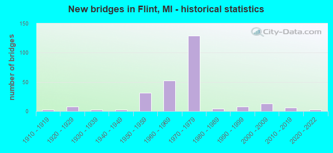
- New bridges - historical statistics
- 11900-1909
- 31910-1919
- 81920-1929
- 31930-1939
- 31940-1949
- 311950-1959
- 521960-1969
- 1291970-1979
- 41980-1989
- 81990-1999
- 132000-2009
- 62010-2019
- 32020-2022
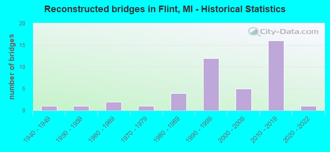
- Reconstructed bridges - Historical Statistics
- 11940-1949
- 11950-1959
- 21960-1969
- 11970-1979
- 41980-1989
- 121990-1999
- 52000-2009
- 162010-2019
- 12020-2022
- Bridge Condition - Deck
- 2.0%Excellent
- 8.6%Very good
- 17.8%Good
- 31.6%Satisfactory
- 26.3%Fair
- 8.6%Poor
- 4.6%Serious
- 0.7%Critical
- Bridge Condition - Superstructure
- 1.3%Excellent
- 13.1%Very good
- 19.0%Good
- 28.1%Satisfactory
- 27.5%Fair
- 6.5%Poor
- 3.9%Serious
- 0.7%Critical
- Bridge Condition - Substructure
- 7.8%Excellent
- 30.1%Very good
- 37.9%Good
- 19.0%Satisfactory
- 3.3%Fair
- 2.0%Poor
- 0.7%Serious
- 0.7%Critical
- Bridge Condition - Channel
- 10.3%Very good
- 42.3%Good
- 25.6%Satisfactory
- 17.9%Fair
- 3.8%Poor
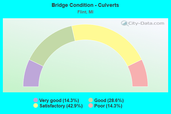
- Bridge Condition - Culverts
- 14.3%Very good
- 28.6%Good
- 42.9%Satisfactory
- 14.3%Poor
Find on map >> Show street view
Structure Number: 2842, Location: IN FLINT (Lat: 42.999500, Lng: -83.707167), Route carried "on" structure: City street 2002, Year Built: 1970, Year Reconstructed: 2012, Status: Open, Structure Length: 2.95m (9.68ft), Average Daily Traffic: 14,129 (year 2014), Truck Traffic: 8%, Average Future Daily Traffic: 17,240 (year 2034), Design Load: HS 20+Mod, Features Intersected: SWARTZ CREEK, Facility Carried by Structure: HAMMERBERG
Minimum Vertical Clearance: 30+ m (98+ ft), Kilometerpoint: 0.626, Lanes on structure: 6, Owner: City or Municipal Highway Agency, Approaching Roadway Width: 18.2m (59.7ft), Material/Design: Prestressed concrete, Design/Construction: Stringer/Multi-beam, Number Of Spans In Main Unit: 3, Length of Maximum Span: 9.7m (31.8ft), Curb or Sidewalk Widths: Left: 1.4m (4.6ft), Right: 1.2m (3.9ft), Curb-To-Curb Width: 23.3m (76.4ft), Out-to-Out Width: 26.8m (87.9ft)
Condition: Deck: Good, Superstructure: Very good, Substructure: Good, Channel: Good, Operating Rating: 49.3 metric tons, Method Used To Determine Operating Rating: Field evaluation and documented engineering judgment, Inventory Rating: 29.7 metric tons, Method Used To Determine Inventory Rating: Field evaluation and documented engineering judgment, Structural Evaluation: Better than present minimum criteria, Deck Geometry: Meets minimum limits, Waterway Adequacy: Equal to present desirable criteria, Approach Roadway Alignment: Equal to present desirable criteria, Designated Inspection Frequency: Every 24 months, Inspection Date: December 2021, Deck Structure Type: Concrete Cast-file-Place, Wearing Surface/Protective System: Wearing Surface: Latex Concrete
Find on map >> Show street view
Structure Number: 2843, Location: 1 BLOCK W OF SAGINAW ST (Lat: 43.017897, Lng: -83.694153), Route carried "on" structure: City street 2002, Year Built: 2007, Status: Open, Structure Length: 5.67m (18.60ft), Average Daily Traffic: 2,929 (year 2005), Truck Traffic: 7%, Average Future Daily Traffic: 5,284 (year 2025), Design Load: HS 20+Mod, Features Intersected: FLINT RIVER, Facility Carried by Structure: BEACH GARLAND STS
Minimum Vertical Clearance: 30.48m (100.00ft), Kilometerpoint: 1.708, Lanes on structure: 3, Owner: City or Municipal Highway Agency, Approaching Roadway Width: 11.3m (37.1ft), Skew: 4 degrees, Material/Design: Prestressed concrete, Design/Construction: Box Beam or Girders - Multiple, Number Of Spans In Main Unit: 2, Length of Maximum Span: 28.4m (93.2ft), Curb or Sidewalk Widths: Left: 2.3m (7.5ft), Right: 2.3m (7.5ft), Curb-To-Curb Width: 11.0m (36.1ft), Out-to-Out Width: 16.2m (53.1ft)
Condition: Deck: Good, Superstructure: Very good, Substructure: Very good, Channel: Good, Operating Rating: 76.8 metric tons, Method Used To Determine Operating Rating: Load Factor (LF) rating reported by rating factor (RF) method using MS18 loading, Inventory Rating: 37.3 metric tons, Method Used To Determine Inventory Rating: Load Factor (LF) rating reported by rating factor (RF) method using MS18 loading, Structural Evaluation: Equal to present desirable criteria, Deck Geometry: High priority of replacement, Waterway Adequacy: Equal to present minimum criteria, Approach Roadway Alignment: Equal to present minimum criteria, Designated Inspection Frequency: Every 24 months, Inspection Date: June 2021, Deck Structure Type: Concrete Cast-file-Place, Wearing Surface/Protective System: Wearing Surface: Integral Concrete, Deck Protection: Epoxy Coated Reinforcing
Find on map >> Show street view
Structure Number: 2844, Location: IN FLINT (Lat: 43.019211, Lng: -83.691614), Route carried "on" structure: City street 2002, Year Built: 1953, Year Reconstructed: 1983, Status: Open, Structure Length: 4.45m (14.60ft), Average Daily Traffic: 6,867 (year 1995), Truck Traffic: 8%, Average Future Daily Traffic: 12,403 (year 2015), Design Load: HS 20+Mod, Features Intersected: FLINT RIVER, Facility Carried by Structure: HARRISON
Minimum Vertical Clearance: 30.48m (100.00ft), Kilometerpoint: 0.946, Lanes on structure: 4, Owner: City or Municipal Highway Agency, Approaching Roadway Width: 13.1m (43.0ft), Skew: 1 degrees, Material/Design: Steel, Design/Construction: Stringer/Multi-beam, Number Of Spans In Main Unit: 3, Number Of Approach Spans: 1, Length of Maximum Span: 17.6m (57.7ft), Curb or Sidewalk Widths: Left: 1.9m (6.2ft), Right: 1.8m (5.9ft), Curb-To-Curb Width: 13.3m (43.6ft), Out-to-Out Width: 17.8m (58.4ft)
Condition: Deck: Fair, Superstructure: Satisfactory, Substructure: Satisfactory, Channel: Good, Operating Rating: 61.2 metric tons, Method Used To Determine Operating Rating: Load Factor (LF) rating reported by rating factor (RF) method using MS18 loading, Inventory Rating: 36.6 metric tons, Method Used To Determine Inventory Rating: Load Factor (LF) rating reported by rating factor (RF) method using MS18 loading, Structural Evaluation: Equal to present minimum criteria, Deck Geometry: High priority of replacement, Waterway Adequacy: Better than present minimum criteria, Approach Roadway Alignment: Better than present minimum criteria, Designated Inspection Frequency: Every 24 months, Inspection Date: June 2021, Deck Structure Type: Concrete Cast-file-Place, Wearing Surface/Protective System: Wearing Surface: Latex Concrete, Deck Protection: Epoxy Coated Reinforcing
Find on map >> Show street view
Structure Number: 2845, Location: IN CITY OF FLINT (Lat: 43.032375, Lng: -83.681211), Route carried "on" structure: City street 2002, Year Built: 1920, Status: Posted for load, Structure Length: 0.97m (3.18ft), Average Daily Traffic: 467 (year 2016), Truck Traffic: 8%, Average Future Daily Traffic: 570 (year 2036), Design Load: HS 20+Mod, Features Intersected: GILKEY CREEK, Facility Carried by Structure: EAST BOULEVARD
Minimum Vertical Clearance: 30.48m (100.00ft), Kilometerpoint: 1.568, Lanes on structure: 2, Owner: City or Municipal Highway Agency, Approaching Roadway Width: 8.2m (26.9ft), Material/Design: Concrete, Design/Construction: Arch - Deck, Number Of Spans In Main Unit: 1, Length of Maximum Span: 9.1m (29.9ft), Curb-To-Curb Width: 7.9m (25.9ft), Out-to-Out Width: 10.6m (34.8ft)
Condition: Deck: Fair, Superstructure: Fair, Substructure: Fair, Channel: Fair, Operating Rating: 63.7 metric tons, Method Used To Determine Operating Rating: Field evaluation and documented engineering judgment, Inventory Rating: 38.2 metric tons, Method Used To Determine Inventory Rating: Field evaluation and documented engineering judgment, Structural Evaluation: Somewhat better than minimum adequacy, Deck Geometry: Somewhat better than minimum adequacy, Waterway Adequacy: Better than present minimum criteria, Approach Roadway Alignment: Better than present minimum criteria, Bridge Posting: Required (Relationship of Operating Rating to Maximum Legal Load: > 39.9% below), Designated Inspection Frequency: Every 24 months, Inspection Date: December 2021
Find on map >> Show street view
Structure Number: 2846, Location: IN FLINT (Lat: 43.030697, Lng: -83.677425), Route carried "on" structure: City street 2002, Year Built: 1976, Status: Open, Structure Length: 0.70m (2.30ft), Average Daily Traffic: 1,734 (year 2017), Truck Traffic: 7%, Average Future Daily Traffic: 2,116 (year 2037), Design Load: HS 20+Mod, Features Intersected: GILKEY CREEK, Facility Carried by Structure: LEWIS NORTH BOUND
Minimum Vertical Clearance: 30.48m (100.00ft), Kilometerpoint: 1.894, Lanes on structure: 2, Owner: City or Municipal Highway Agency, Approaching Roadway Width: 8.5m (27.9ft), Material/Design: Prestressed concrete, Design/Construction: Box Beam or Girders - Multiple, Number Of Spans In Main Unit: 1, Length of Maximum Span: 7.0m (23.0ft), Curb or Sidewalk Widths: Left: 0.0m, Right: 1.5m (4.9ft), Curb-To-Curb Width: 10.3m (33.8ft), Out-to-Out Width: 12.8m (42.0ft)
Condition: Deck: Good, Superstructure: Good, Substructure: Satisfactory, Channel: Satisfactory, Inventory Rating: 97.0 metric tons, Method Used To Determine Inventory Rating: Field evaluation and documented engineering judgment, Structural Evaluation: Equal to present minimum criteria, Deck Geometry: Somewhat better than minimum adequacy, Waterway Adequacy: Equal to present desirable criteria, Approach Roadway Alignment: Equal to present desirable criteria, Designated Inspection Frequency: Every 24 months, Inspection Date: December 2021, Deck Structure Type: Concrete Cast-file-Place, Wearing Surface/Protective System: Wearing Surface: Monolithic Concrete
Find on map >> Show street view
Structure Number: 2847, Location: IN CITY OF FLINT (Lat: 43.027133, Lng: -83.671111), Route carried "on" structure: City street 2002, Year Built: 1920, Status: Posted for load, Structure Length: 0.97m (3.18ft), Average Daily Traffic: 4,837 (year 2015), Truck Traffic: 3%, Average Future Daily Traffic: 5,902 (year 2035), Design Load: HS 20+Mod, Features Intersected: GILKEY CREEK, Facility Carried by Structure: KEARSLEY PARK BLVD
Minimum Vertical Clearance: 30.48m (100.00ft), Kilometerpoint: 0.219, Lanes on structure: 2, Owner: City or Municipal Highway Agency, Approaching Roadway Width: 10.1m (33.1ft), Material/Design: Concrete, Design/Construction: Arch - Deck, Number Of Spans In Main Unit: 1, Length of Maximum Span: 7.9m (25.9ft), Curb or Sidewalk Widths: Left: 1.8m (5.9ft), Right: 1.7m (5.6ft), Curb-To-Curb Width: 9.8m (32.2ft), Out-to-Out Width: 14.3m (46.9ft)
Condition: Deck: Satisfactory, Superstructure: Satisfactory, Substructure: Satisfactory, Channel: Fair, Operating Rating: 7.5 metric tons, Method Used To Determine Operating Rating: Field evaluation and documented engineering judgment, Inventory Rating: 4.6 metric tons, Method Used To Determine Inventory Rating: Field evaluation and documented engineering judgment, Structural Evaluation: High priority of replacement, Deck Geometry: Meets minimum limits, Waterway Adequacy: Equal to present minimum criteria, Approach Roadway Alignment: Equal to present minimum criteria, Bridge Posting: Required (Relationship of Operating Rating to Maximum Legal Load: > 39.9% below), Length Of Structure Improvement: 0.79m (2.59ft), Designated Inspection Frequency: Every 12 months, Inspection Date: December 2021, Bridge Improvement Cost: $460,000, Roadway Improvement Cost: $150,000, Total Project Cost: $610,000, Wearing Surface/Protective System: Wearing Surface: Bituminous
Find on map >> Show street view
Structure Number: 2848, Location: IN CITY OF FLINT (Lat: 43.003292, Lng: -83.683775), Route carried "on" structure: City street 2002, Year Built: 1958, Year Reconstructed: 2013, Status: Open, Structure Length: 1.45m (4.76ft), Average Daily Traffic: 7,911 (year 2012), Truck Traffic: 5%, Average Future Daily Traffic: 8,741 (year 2032), Design Load: HS 20+Mod, Features Intersected: THREAD CREEK, Facility Carried by Structure: S GRAND TRAVERSE
Minimum Vertical Clearance: 30.48m (100.00ft), Kilometerpoint: 3.227, Lanes on structure: 4, Owner: City or Municipal Highway Agency, Approaching Roadway Width: 14.3m (46.9ft), Skew: 2 degrees, Material/Design: Prestressed concrete, Design/Construction: Box Beam or Girders - Single/Spread, Number Of Spans In Main Unit: 1, Length of Maximum Span: 13.0m (42.7ft), Curb or Sidewalk Widths: Left: 1.6m (5.2ft), Right: 1.6m (5.2ft), Curb-To-Curb Width: 14.3m (46.9ft), Out-to-Out Width: 19.5m (64.0ft)
Condition: Deck: Very good, Superstructure: Very good, Substructure: Very good, Channel: Good, Operating Rating: 75.8 metric tons, Method Used To Determine Operating Rating: Load and Resistance Factor Rating (LRFR) rating reported by rating factor(RF) method using HL-93 loadings, Inventory Rating: 58.6 metric tons, Method Used To Determine Inventory Rating: Load and Resistance Factor Rating (LRFR) rating reported by rating factor(RF) method using HL-93 loadings, Structural Evaluation: Equal to present desirable criteria, Deck Geometry: High priority of replacement, Waterway Adequacy: Equal to present desirable criteria, Approach Roadway Alignment: Equal to present desirable criteria, Designated Inspection Frequency: Every 24 months, Inspection Date: December 2021, Deck Structure Type: Concrete Cast-file-Place, Wearing Surface/Protective System: Wearing Surface: Monolithic Concrete, Deck Protection: Epoxy Coated Reinforcing
Find on map >> Show street view
Structure Number: 2849, Location: IN FLINT (Lat: 43.018778, Lng: -83.693108), Route carried "on" structure: City street 2002, Year Built: 1976, Status: Open, Structure Length: 4.69m (15.39ft), Average Daily Traffic: 14,204 (year 2018), Truck Traffic: 10%, Average Future Daily Traffic: 17,333 (year 2038), Design Load: HS 20+Mod, Features Intersected: FLINT RIVER, Facility Carried by Structure: SAGINAW STREET
Minimum Vertical Clearance: 30.48m (100.00ft), Kilometerpoint: 18.856, Lanes on structure: 4, Owner: City or Municipal Highway Agency, Approaching Roadway Width: 18.2m (59.7ft), Skew: 20 degrees, Material/Design: Prestressed concrete, Design/Construction: Stringer/Multi-beam, Number Of Spans In Main Unit: 3, Length of Maximum Span: 15.6m (51.2ft), Curb or Sidewalk Widths: Left: 2.6m (8.5ft), Right: 2.6m (8.5ft), Curb-To-Curb Width: 17.9m (58.7ft), Out-to-Out Width: 24.1m (79.1ft)
Condition: Deck: Satisfactory, Superstructure: Satisfactory, Substructure: Satisfactory, Channel: Very good, Operating Rating: 97.2 metric tons, Method Used To Determine Operating Rating: Load Factor (LF) rating reported by rating factor (RF) method using MS18 loading, Inventory Rating: 81.3 metric tons, Method Used To Determine Inventory Rating: Load Factor (LF) rating reported by rating factor (RF) method using MS18 loading, Structural Evaluation: Equal to present minimum criteria, Deck Geometry: Somewhat better than minimum adequacy, Waterway Adequacy: Equal to present desirable criteria, Approach Roadway Alignment: Equal to present desirable criteria, Designated Inspection Frequency: Every 24 months, Inspection Date: October 2020, Deck Structure Type: Concrete Cast-file-Place, Wearing Surface/Protective System: Wearing Surface: Epoxy Overlay
Find on map >> Show street view
Structure Number: 285, Location: IN FLINT (Lat: 43.002106, Lng: -83.678381), Route carried "on" structure: City street , Year Built: 1940, Status: Posted for load, Structure Length: 1.16m (3.81ft), Average Daily Traffic: 4,837 (year 2015), Truck Traffic: 3%, Average Future Daily Traffic: 5,902 (year 2035), Design Load: HS 20+Mod, Features Intersected: THREAD CREEK, Facility Carried by Structure: BARTON ROAD
Minimum Vertical Clearance: 30.48m (100.00ft), Kilometerpoint: 0.140, Lanes on structure: 2, Owner: City or Municipal Highway Agency, Approaching Roadway Width: 8.2m (26.9ft), Material/Design: Steel, Design/Construction: Stringer/Multi-beam, Number Of Spans In Main Unit: 1, Length of Maximum Span: 11.2m (36.7ft), Curb or Sidewalk Widths: Left: 1.5m (4.9ft), Right: 1.5m (4.9ft), Curb-To-Curb Width: 7.9m (25.9ft), Out-to-Out Width: 12.1m (39.7ft)
Condition: Deck: Good, Superstructure: Fair, Substructure: Satisfactory, Channel: Poor, Operating Rating: 35.6 metric tons, Method Used To Determine Operating Rating: Load Factor (LF) rating reported by rating factor (RF) method using MS18 loading, Inventory Rating: 21.4 metric tons, Method Used To Determine Inventory Rating: Load Factor (LF) rating reported by rating factor (RF) method using MS18 loading, Structural Evaluation: Somewhat better than minimum adequacy, Deck Geometry: High priority of corrective action, Waterway Adequacy: Equal to present minimum criteria, Approach Roadway Alignment: Equal to present minimum criteria, Bridge Posting: Required (Relationship of Operating Rating to Maximum Legal Load: 10.0 - 19.9% below), Length Of Structure Improvement: 1.74m (5.71ft), Designated Inspection Frequency: Every 24 months, Inspection Date: November 2020, Bridge Improvement Cost: $95,000, Roadway Improvement Cost: $8,000, Total Project Cost: $106,000, Deck Structure Type: Concrete Cast-file-Place, Wearing Surface/Protective System: Wearing Surface: Bituminous
Find on map >> Show street view
Structure Number: 2851, Location: IN FLINT (Lat: 42.997300, Lng: -83.707200), Route carried "on" structure: City street , Year Built: 1970, Status: Open, Structure Length: 2.40m (7.87ft), Average Daily Traffic: 50 (year 2017), Truck Traffic: 3%, Average Future Daily Traffic: 100 (year 2037), Design Load: HS 20+Mod, Features Intersected: SWARTZ CREEK, Facility Carried by Structure: CAMBRIDGE AVENUE
Minimum Vertical Clearance: 30.48m (100.00ft), Kilometerpoint: 0.061, Lanes on structure: 2, Owner: City or Municipal Highway Agency, Approaching Roadway Width: 9.8m (32.2ft), Skew: 2 degrees, Material/Design: Prestressed concrete, Design/Construction: Stringer/Multi-beam, Number Of Spans In Main Unit: 3, Length of Maximum Span: 7.9m (25.9ft), Curb or Sidewalk Widths: Left: 0.0m, Right: 1.8m (5.9ft), Curb-To-Curb Width: 7.6m (24.9ft), Out-to-Out Width: 10.4m (34.1ft)
Condition: Deck: Good, Superstructure: Very good, Substructure: Good, Channel: Satisfactory, Operating Rating: 59.0 metric tons, Method Used To Determine Operating Rating: Load Factor (LF) rating reported by rating factor (RF) method using MS18 loading, Inventory Rating: 35.3 metric tons, Method Used To Determine Inventory Rating: Load Factor (LF) rating reported by rating factor (RF) method using MS18 loading, Structural Evaluation: Better than present minimum criteria, Deck Geometry: Equal to present minimum criteria, Waterway Adequacy: Equal to present minimum criteria, Approach Roadway Alignment: Equal to present minimum criteria, Designated Inspection Frequency: Every 24 months, Inspection Date: December 2021, Deck Structure Type: Concrete Cast-file-Place, Wearing Surface/Protective System: Wearing Surface: Monolithic Concrete
Find on map >> Show street view
Structure Number: 2852, Location: IN FLINT (Lat: 43.011328, Lng: -83.668539), Route carried "on" structure: City street , Year Built: 1971, Status: Posted for load, Structure Length: 0.70m (2.30ft), Average Daily Traffic: 270 (year 1995), Truck Traffic: 2%, Average Future Daily Traffic: 488 (year 2015), Design Load: HS 20+Mod, Features Intersected: GILKEY CREEK, Facility Carried by Structure: SUNNYSIDE AVENUE
Minimum Vertical Clearance: 30.48m (100.00ft), Kilometerpoint: 0.014, Lanes on structure: 2, Owner: City or Municipal Highway Agency, Approaching Roadway Width: 9.4m (30.8ft), Material/Design: Concrete, Design/Construction: Culvert, Number Of Spans In Main Unit: 2, Length of Maximum Span: 3.3m (10.8ft), Curb or Sidewalk Widths: Left: 1.8m (5.9ft), Right: 0.0m, Curb-To-Curb Width: 9.1m (29.9ft), Out-to-Out Width: 11.8m (38.7ft)
Condition: Channel: Satisfactory, Culverts: Good, Operating Rating: 63.7 metric tons, Method Used To Determine Operating Rating: Field evaluation and documented engineering judgment, Inventory Rating: 38.2 metric tons, Method Used To Determine Inventory Rating: Field evaluation and documented engineering judgment, Structural Evaluation: Better than present minimum criteria, Deck Geometry: Equal to present minimum criteria, Waterway Adequacy: Equal to present desirable criteria, Approach Roadway Alignment: Equal to present minimum criteria, Bridge Posting: Required (Relationship of Operating Rating to Maximum Legal Load: > 39.9% below), Designated Inspection Frequency: Every 24 months, Inspection Date: December 2021, Deck Structure Type: Concrete Cast-file-Place, Wearing Surface/Protective System: Wearing Surface: Monolithic Concrete
Find on map >> Show street view
Structure Number: 2853, Location: IN CITY OF FLINT (Lat: 43.055911, Lng: -83.656625), Route carried "on" structure: City street 2002, Year Built: 1928, Status: Posted for load, Structure Length: 1.92m (6.30ft), Average Daily Traffic: 5,538 (year 2008), Truck Traffic: 8%, Average Future Daily Traffic: 6,758 (year 2028), Design Load: HS 20+Mod, Features Intersected: KEARSLEY CREEK, Facility Carried by Structure: WESTERN ROAD
Minimum Vertical Clearance: 30.48m (100.00ft), Kilometerpoint: 1.645, Lanes on structure: 2, Owner: City or Municipal Highway Agency, Approaching Roadway Width: 7.3m (24.0ft), Material/Design: Concrete continuous, Design/Construction: Tee Beam, Number Of Spans In Main Unit: 3, Length of Maximum Span: 8.2m (26.9ft), Curb or Sidewalk Widths: Left: 0.0m, Right: 1.3m (4.3ft), Curb-To-Curb Width: 6.8m (22.3ft), Out-to-Out Width: 9.1m (29.9ft)
Condition: Deck: Poor, Superstructure: Poor, Substructure: Fair, Channel: Good, Operating Rating: 15.5 metric tons, Method Used To Determine Operating Rating: Load Factor (LF), Inventory Rating: 9.4 metric tons, Method Used To Determine Inventory Rating: Load Factor (LF), Structural Evaluation: High priority of corrective action, Deck Geometry: High priority of replacement, Waterway Adequacy: Equal to present minimum criteria, Approach Roadway Alignment: Better than present minimum criteria, Bridge Posting: Required (Relationship of Operating Rating to Maximum Legal Load: > 39.9% below), Designated Inspection Frequency: Every 12 months, Inspection Date: December 2021, Deck Structure Type: Concrete Cast-file-Place, Wearing Surface/Protective System: Wearing Surface: Bituminous
Find on map >> Show street view
Structure Number: 2855, Location: IN FLINT (Lat: 42.996858, Lng: -83.648019), Route carried "on" structure: City street , Year Built: 1970, Status: Posted for load, Structure Length: 2.13m (6.99ft), Truck Traffic: 5%, Average Future Daily Traffic: 385 (year 2015), Design Load: HS 20+Mod, Features Intersected: THREAD CREEK, Facility Carried by Structure: CHAMBERS STREET
Minimum Vertical Clearance: 30+ m (98+ ft), Kilometerpoint: 0.845, Lanes on structure: 2, Owner: City or Municipal Highway Agency, Approaching Roadway Width: 8.2m (26.9ft), Skew: 3 degrees, Material/Design: Steel, Design/Construction: Culvert, Number Of Spans In Main Unit: 4, Length of Maximum Span: 5.7m (18.7ft), Curb or Sidewalk Widths: Left: 0.0m, Right: 1.5m (4.9ft)
Condition: Channel: Satisfactory, Culverts: Poor, Operating Rating: 16.8 metric tons, Method Used To Determine Operating Rating: Load Factor (LF) rating reported by rating factor (RF) method using MS18 loading, Inventory Rating: 12.0 metric tons, Method Used To Determine Inventory Rating: Load Factor (LF) rating reported by rating factor (RF) method using MS18 loading, Structural Evaluation: Meets minimum limits, Waterway Adequacy: High priority of corrective action, Approach Roadway Alignment: Better than present minimum criteria, Bridge Posting: Required (Relationship of Operating Rating to Maximum Legal Load: > 39.9% below), Designated Inspection Frequency: Every 12 months, Inspection Date: December 2021, Wearing Surface/Protective System: Wearing Surface: Bituminous
Find on map >> Show street view
Structure Number: 2856, Location: CITY OF FLINT (Lat: 42.997200, Lng: -83.708200), Route carried "on" structure: City street , Year Built: 1924, Status: Posted for load, Structure Length: 1.82m (5.97ft), Truck Traffic: 1%, Average Future Daily Traffic: 50 (year 2010), Design Load: H 15, Features Intersected: SWARTZ CREEK, Facility Carried by Structure: OLD CAMBRIDGE AVE
Minimum Vertical Clearance: 30.48m (100.00ft), Kilometerpoint: 0.282, Lanes on structure: 2, Owner: City or Municipal Highway Agency, Approaching Roadway Width: 7.3m (24.0ft), Material/Design: Concrete, Design/Construction: Arch - Deck, Number Of Spans In Main Unit: 1, Length of Maximum Span: 18.2m (59.7ft), Curb or Sidewalk Widths: Left: 0.1m (0.3ft), Right: 2.5m (8.2ft), Curb-To-Curb Width: 7.4m (24.3ft), Out-to-Out Width: 10.5m (34.4ft)
Condition: Deck: Poor, Superstructure: Poor, Substructure: Poor, Channel: Good, Operating Rating: 54.5 metric tons, Method Used To Determine Operating Rating: Field evaluation and documented engineering judgment, Inventory Rating: 32.7 metric tons, Method Used To Determine Inventory Rating: Field evaluation and documented engineering judgment, Structural Evaluation: Meets minimum limits, Deck Geometry: Equal to present minimum criteria, Waterway Adequacy: Equal to present minimum criteria, Approach Roadway Alignment: Equal to present minimum criteria, Bridge Posting: Required (Relationship of Operating Rating to Maximum Legal Load: 30.0 - 39.9% below), Designated Inspection Frequency: Every 24 months, Inspection Date: December 2021, Wearing Surface/Protective System: Wearing Surface: Bituminous
Find on map >> Show street view
Structure Number: 2857, Location: IN FLINT (Lat: 43.000178, Lng: -83.679739), Route carried "on" structure: City street , Year Built: 1964, Status: Posted for load, Structure Length: 1.03m (3.38ft), Truck Traffic: 2%, Average Future Daily Traffic: 2,048 (year 2015), Design Load: HS 20+Mod, Features Intersected: THREAD CREEK, Facility Carried by Structure: BEACH STREET
Minimum Vertical Clearance: 30.48m (100.00ft), Kilometerpoint: 0.267, Lanes on structure: 2, Owner: City or Municipal Highway Agency, Approaching Roadway Width: 9.4m (30.8ft), Material/Design: Steel, Design/Construction: Stringer/Multi-beam, Number Of Spans In Main Unit: 1, Length of Maximum Span: 9.7m (31.8ft), Curb or Sidewalk Widths: Left: 2.6m (8.5ft), Right: 1.7m (5.6ft), Curb-To-Curb Width: 9.4m (30.8ft), Out-to-Out Width: 14.4m (47.2ft)
Condition: Deck: Fair, Superstructure: Serious, Substructure: Fair, Channel: Good, Operating Rating: 29.2 metric tons, Method Used To Determine Operating Rating: Load Factor (LF) rating reported by rating factor (RF) method using MS18 loading, Inventory Rating: 17.5 metric tons, Method Used To Determine Inventory Rating: Load Factor (LF) rating reported by rating factor (RF) method using MS18 loading, Structural Evaluation: High priority of corrective action, Deck Geometry: Better than present minimum criteria, Waterway Adequacy: Meets minimum limits, Approach Roadway Alignment: Meets minimum limits, Bridge Posting: Required (Relationship of Operating Rating to Maximum Legal Load: 30.0 - 39.9% below), Designated Inspection Frequency: Every 12 months, Inspection Date: December 2021, Deck Structure Type: Concrete Cast-file-Place, Wearing Surface/Protective System: Wearing Surface: Monolithic Concrete
Find on map >> Show street view
Structure Number: 2858, Location: IN FLINT (Lat: 43.054067, Lng: -83.668239), Route carried "on" structure: City street , Year Built: 1962, Status: Open, Structure Length: 3.04m (9.97ft), Average Daily Traffic: 4,130 (year 2001), Truck Traffic: 8%, Average Future Daily Traffic: 5,040 (year 2021), Design Load: HS 20+Mod, Features Intersected: KEARSLEY CREEK, Facility Carried by Structure: EAST BOULEVARD
Minimum Vertical Clearance: 30.48m (100.00ft), Kilometerpoint: 0.119, Lanes on structure: 2, Owner: City or Municipal Highway Agency, Approaching Roadway Width: 9.4m (30.8ft), Material/Design: Prestressed concrete, Design/Construction: Box Beam or Girders - Multiple, Number Of Spans In Main Unit: 3, Length of Maximum Span: 12.2m (40.0ft), Curb or Sidewalk Widths: Left: 0.0m, Right: 1.5m (4.9ft), Curb-To-Curb Width: 9.1m (29.9ft), Out-to-Out Width: 11.7m (38.4ft)
Condition: Deck: Satisfactory, Superstructure: Satisfactory, Substructure: Satisfactory, Channel: Fair, Operating Rating: 52.8 metric tons, Method Used To Determine Operating Rating: Load Factor (LF) rating reported by rating factor (RF) method using MS18 loading, Inventory Rating: 31.8 metric tons, Method Used To Determine Inventory Rating: Load Factor (LF) rating reported by rating factor (RF) method using MS18 loading, Structural Evaluation: Equal to present minimum criteria, Deck Geometry: Meets minimum limits, Waterway Adequacy: Better than present minimum criteria, Approach Roadway Alignment: Equal to present minimum criteria, Designated Inspection Frequency: Every 24 months, Inspection Date: December 2021, Deck Structure Type: Concrete Cast-file-Place, Wearing Surface/Protective System: Wearing Surface: Bituminous
Find on map >> Show street view
Structure Number: 12825, Location: E OF I-69 (Lat: 42.972931, Lng: -83.757608), Route carried "on" structure: County highway 121, Year Built: 1999, Status: Open, Structure Length: 5.23m (17.16ft), Average Daily Traffic: 11,132 (year 2014), Truck Traffic: 11%, Average Future Daily Traffic: 20,107 (year 2034), Design Load: HS 25 or greater, Features Intersected: GTW RR, Facility Carried by Structure: BRISTOL RD
Minimum Vertical Clearance: 30.48m (100.00ft), Kilometerpoint: 1.716, Lanes on structure: 4, Base Highway Network: Yes (Inventory Route: 150, Subroute: 10), Owner: County Highway Agency, Approaching Roadway Width: 19.8m (65.0ft), Skew: 1 degrees, Material/Design: Prestressed concrete, Design/Construction: Stringer/Multi-beam, Number Of Spans In Main Unit: 1, Length of Maximum Span: 52.3m (171.6ft), Curb or Sidewalk Widths: Left: 1.6m (5.2ft), Right: 1.6m (5.2ft), Curb-To-Curb Width: 19.5m (64.0ft), Out-to-Out Width: 39.3m (128.9ft)
Condition: Deck: Good, Superstructure: Very good, Substructure: Good, Operating Rating: 72.6 metric tons, Method Used To Determine Operating Rating: Load Factor (LF) rating reported by rating factor (RF) method using MS18 loading, Inventory Rating: 44.4 metric tons, Method Used To Determine Inventory Rating: Load Factor (LF) rating reported by rating factor (RF) method using MS18 loading, Structural Evaluation: Better than present minimum criteria, Deck Geometry: Better than present minimum criteria, Underclear: High priority of corrective action, Approach Roadway Alignment: Equal to present desirable criteria, Designated Inspection Frequency: Every 24 months, Inspection Date: November 2020, Deck Structure Type: Concrete Cast-file-Place, Wearing Surface/Protective System: Wearing Surface: Monolithic Concrete, Deck Protection: Epoxy Coated Reinforcing
Find on map >> Show street view
Structure Number: 13168, Location: FLINT TWP SEC 33 (Lat: 42.964667, Lng: -83.766919), Route carried "on" structure: County highway , Year Built: 2000, Status: Open, Structure Length: 1.28m (4.20ft), Average Daily Traffic: 77 (year 2000), Average Future Daily Traffic: 137 (year 2020), Design Load: HS 25 or greater, Features Intersected: HEWITT DRAIN, Facility Carried by Structure: LINDEN CRK PARKWAY
Minimum Vertical Clearance: 30.48m (100.00ft), Kilometerpoint: 0.391, Lanes on structure: 2, Owner: County Highway Agency, Approaching Roadway Width: 7.9m (25.9ft), Material/Design: Concrete, Design/Construction: Culvert, Number Of Spans In Main Unit: 1, Length of Maximum Span: 12.8m (42.0ft), Curb or Sidewalk Widths: Left: 0.6m (2.0ft), Right: 0.6m (2.0ft), Curb-To-Curb Width: 7.6m (24.9ft), Out-to-Out Width: 8.8m (28.9ft)
Condition: Channel: Satisfactory, Culverts: Good, Operating Rating: 95.6 metric tons, Method Used To Determine Operating Rating: Load and Resistance Factor Rating (LRFR) rating reported by rating factor(RF) method using HL-93 loadings, Inventory Rating: 73.9 metric tons, Method Used To Determine Inventory Rating: Load and Resistance Factor Rating (LRFR) rating reported by rating factor(RF) method using HL-93 loadings, Structural Evaluation: Better than present minimum criteria, Deck Geometry: Equal to present minimum criteria, Waterway Adequacy: Better than present minimum criteria, Approach Roadway Alignment: Equal to present desirable criteria, Designated Inspection Frequency: Every 24 months, Inspection Date: November 2020
Find on map >> Show street view
Structure Number: 2482, Location: 7.3 MI N OF FENTON (Lat: 42.914728, Lng: -83.725861), Route carried "under" structure: US 23, Year Built: 1957, Structure Length: 0. m, Average Daily Traffic: 49,260 (year 2007), Truck Traffic: 9%, Features Intersected: US-23, Facility Carried by Structure: GRAND BLANC RD
Minimum Vertical Clearance: 4.93m (16.17ft), Kilometerpoint: 15.613, Lanes on structure: 4, Lanes under structure: 6, Material/Design: Steel, Design/Construction: Stringer/Multi-beam, Length of Maximum Span: 18.2m (59.7ft)
Find on map >> Show street view
Structure Number: 2483, Location: 2.0 MI S OF M-121 (Lat: 42.944017, Lng: -83.723808), Route carried "under" structure: US 23, Year Built: 2005, Structure Length: 0. m, Average Daily Traffic: 55,924 (year 2007), Truck Traffic: 9%, Features Intersected: US-23, Facility Carried by Structure: HILL RD
Minimum Vertical Clearance: 4.93m (16.17ft), Kilometerpoint: 18.883, Lanes on structure: 5, Lanes under structure: 4, Material/Design: Steel continuous, Design/Construction: Stringer/Multi-beam, Length of Maximum Span: 25.7m (84.3ft)
Find on map >> Show street view
Structure Number: 2484, Location: 0.4 MI S OF FLINT (Lat: 42.959031, Lng: -83.725100), Route carried "under" structure: Interstate 75, Year Built: 1957, Structure Length: 0. m, Average Daily Traffic: 91,300 (year 2013), Truck Traffic: 7%, Features Intersected: I-75, Facility Carried by Structure: MAPLE RD
Minimum Vertical Clearance: 4.52m (14.83ft), Kilometerpoint: 14.671, Lanes on structure: 2, Lanes under structure: 6, Material/Design: Steel, Design/Construction: Stringer/Multi-beam, Length of Maximum Span: 16.2m (53.1ft)
Find on map >> Show street view
Structure Number: 2485, Location: 1.0 MI SW OF FLINT (Lat: 42.973497, Lng: -83.725639), Route carried "under" structure: County highway 121, Year Built: 2005, Structure Length: 0. m, Average Daily Traffic: 19,300 (year 2002), Truck Traffic: 9%, Features Intersected: BRISTOL RD, Facility Carried by Structure: I-75
Minimum Vertical Clearance: 4.85m (15.91ft), Kilometerpoint: 0.557, Lanes on structure: 8, Lanes under structure: 6, Material/Design: Steel continuous, Design/Construction: Stringer/Multi-beam, Length of Maximum Span: 23.5m (77.1ft)
Find on map >> Show street view
Structure Number: 2486, Location: W LTS OF FLINT (Lat: 42.989736, Lng: -83.738514), Route carried "under" structure: Interstate 75, Year Built: 1954, Structure Length: 0. m, Average Daily Traffic: 89,348 (year 2007), Truck Traffic: 6%, Features Intersected: I-75, Facility Carried by Structure: MILLER RD
Minimum Vertical Clearance: 4.42m (14.50ft), Kilometerpoint: 18.416, Lanes on structure: 4, Lanes under structure: 9, Material/Design: Steel, Design/Construction: Stringer/Multi-beam, Length of Maximum Span: 19.5m (64.0ft)
Find on map >> Show street view
Structure Number: 2497, Location: S OF M-21 (Lat: 42.995283, Lng: -83.747628), Route carried "under" structure: Interstate 75, Year Built: 1957, Structure Length: 0. m, Average Daily Traffic: 89,348 (year 2007), Truck Traffic: 6%, Features Intersected: I-75, Facility Carried by Structure: HOGARTH ST WALKOER
Minimum Vertical Clearance: 5.00m (16.40ft), Kilometerpoint: 19.384, Lanes under structure: 7, Material/Design: Steel, Design/Construction: Girder and Floorbeam System, Length of Maximum Span: 25.9m (85.0ft)
Find on map >> Show street view
Structure Number: 2498, Location: S OF M-21 (Lat: 42.998781, Lng: -83.749369), Route carried "under" structure: Interstate 75, Year Built: 1957, Structure Length: 0. m, Average Daily Traffic: 89,348 (year 2007), Truck Traffic: 6%, Features Intersected: I-75, Facility Carried by Structure: ARLENE DRIVE
Minimum Vertical Clearance: 5.16m (16.93ft), Kilometerpoint: 19.804, Lanes on structure: 2, Lanes under structure: 6, Material/Design: Steel, Design/Construction: Stringer/Multi-beam, Length of Maximum Span: 17.1m (56.1ft)
Find on map >> Show street view
Structure Number: 2499, Location: NEAR W LTS OF FLINT (Lat: 43.002142, Lng: -83.749369), Route carried "under" structure: Interstate 75, Year Built: 2009, Structure Length: 0. m, Average Daily Traffic: 89,348 (year 2007), Truck Traffic: 6%, Features Intersected: I-75, Facility Carried by Structure: M-21
Minimum Vertical Clearance: 4.65m (15.26ft), Kilometerpoint: 20.177, Lanes on structure: 6, Lanes under structure: 7, Material/Design: Prestressed concrete, Design/Construction: Stringer/Multi-beam, Length of Maximum Span: 32.4m (106.3ft)
Find on map >> Show street view
Structure Number: 25, Location: N OF M-21 (Lat: 43.006892, Lng: -83.748739), Route carried "under" structure: County highway , Year Built: 1957, Structure Length: 0. m, Average Daily Traffic: 9,348 (year 1995), Truck Traffic: 3%, Features Intersected: COURT ST, Facility Carried by Structure: I-75
Minimum Vertical Clearance: 4.09m (13.42ft), Kilometerpoint: 5.177, Lanes on structure: 6, Lanes under structure: 2, Material/Design: Steel, Design/Construction: Stringer/Multi-beam, Length of Maximum Span: 12.6m (41.3ft)
Find on map >> Show street view
Structure Number: 2501, Location: 1 MI N OF M-21 (Lat: 43.016925, Lng: -83.748086), Route carried "under" structure: Interstate 75, Year Built: 1958, Structure Length: 0. m, Average Daily Traffic: 70,414 (year 2007), Truck Traffic: 6%, Features Intersected: I-75, Facility Carried by Structure: BEECHER RD
Minimum Vertical Clearance: 4.88m (16.01ft), Kilometerpoint: 21.835, Lanes on structure: 2, Lanes under structure: 6, Material/Design: Steel, Design/Construction: Stringer/Multi-beam, Length of Maximum Span: 28.1m (92.2ft)
Find on map >> Show street view
Structure Number: 2502, Location: N OF FLINT RIVER (Lat: 43.032339, Lng: -83.754042), Route carried "under" structure: County highway 2002, Year Built: 1958, Structure Length: 0. m, Average Daily Traffic: 16,078 (year 1996), Truck Traffic: 3%, Features Intersected: FLUSHING RD, Facility Carried by Structure: I-75 NB
Minimum Vertical Clearance: 4.67m (15.32ft), Kilometerpoint: 10.175, Lanes on structure: 3, Lanes under structure: 4, Material/Design: Concrete continuous, Design/Construction: Tee Beam, Length of Maximum Span: 21.3m (69.9ft)
Find on map >> Show street view
Structure Number: 2503, Location: N OF FLINT RIVER (Lat: 43.032475, Lng: -83.754325), Route carried "under" structure: County highway 2002, Year Built: 1958, Structure Length: 0. m, Average Daily Traffic: 16,078 (year 1996), Truck Traffic: 3%, Features Intersected: FLUSHING RD, Facility Carried by Structure: I-75 SB
Minimum Vertical Clearance: 5.26m (17.26ft), Kilometerpoint: 10.147, Lanes on structure: 3, Lanes under structure: 4, Material/Design: Concrete continuous, Design/Construction: Tee Beam, Length of Maximum Span: 22.6m (74.1ft)
Find on map >> Show street view
Structure Number: 2504, Location: 3 MI N OF M-21 (Lat: 43.046078, Lng: -83.754781), Route carried "under" structure: Interstate 75, Year Built: 1958, Structure Length: 0. m, Average Daily Traffic: 70,414 (year 2007), Truck Traffic: 6%, Features Intersected: I-75, Facility Carried by Structure: PASADENA AVE
Minimum Vertical Clearance: 4.52m (14.83ft), Kilometerpoint: 25.213, Lanes on structure: 2, Lanes under structure: 6, Material/Design: Steel, Design/Construction: Stringer/Multi-beam, Length of Maximum Span: 19.4m (63.6ft)
Find on map >> Show street view
Structure Number: 2505, Location: 4 MI N OF M-21 (Lat: 43.060653, Lng: -83.762297), Route carried "under" structure: Interstate 75, Year Built: 1973, Structure Length: 0. m, Average Daily Traffic: 70,414 (year 2007), Truck Traffic: 8%, Features Intersected: I-75, Facility Carried by Structure: PIERSON RD
Minimum Vertical Clearance: 5.08m (16.67ft), Kilometerpoint: 26.956, Lanes on structure: 5, Lanes under structure: 8, Material/Design: Steel, Design/Construction: Stringer/Multi-beam, Length of Maximum Span: 34.7m (113.8ft)
Find on map >> Show street view
Structure Number: 2506, Location: 5.4 MI N OF M-21 (Lat: 43.075242, Lng: -83.762578), Route carried "under" structure: Interstate 75, Year Built: 1957, Structure Length: 0. m, Average Daily Traffic: 64,650 (year 2007), Truck Traffic: 8%, Features Intersected: I-75, Facility Carried by Structure: CARPENTER RD
Minimum Vertical Clearance: 4.37m (14.34ft), Kilometerpoint: 28.575, Lanes on structure: 2, Lanes under structure: 6, Material/Design: Steel, Design/Construction: Stringer/Multi-beam, Length of Maximum Span: 21.2m (69.6ft)
Find on map >> Show street view
Structure Number: 2525, Location: NB I-75 RMP TO WB I-69 (Lat: 42.982806, Lng: -83.731000), Route carried "under" structure: Interstate 75, Year Built: 1969, Structure Length: 0. m, Average Daily Traffic: 44,200 (year 0000), Features Intersected: GTW RR &I-75
Minimum Vertical Clearance: 6.10m (20.01ft), Kilometerpoint: 17.584, Lanes on structure: 2, Lanes under structure: 6, Material/Design: Steel, Design/Construction: Stringer/Multi-beam, Length of Maximum Span: 44.2m (145.0ft)
Find on map >> Show street view
Structure Number: 2538, Location: 2.0 MI SW OF FLINT (Lat: 42.969814, Lng: -83.771850), Route carried "under" structure: County highway 2002, Year Built: 1968, Structure Length: 0. m, Average Daily Traffic: 13,402 (year 1996), Truck Traffic: 3%, Features Intersected: LINDEN RD, Facility Carried by Structure: I-69 EB
Minimum Vertical Clearance: 5.13m (16.83ft), Kilometerpoint: 21.923, Lanes on structure: 3, Lanes under structure: 2, Material/Design: Prestressed concrete, Design/Construction: Stringer/Multi-beam, Length of Maximum Span: 20.4m (66.9ft)
Find on map >> Show street view
Structure Number: 2539, Location: 2.4 MI E OF SWARTZ CREEK (Lat: 42.972867, Lng: -83.765156), Route carried "under" structure: County highway 121, Year Built: 1968, Structure Length: 0. m, Average Daily Traffic: 15,247 (year 2002), Truck Traffic: 3%, Features Intersected: BRISTOL RD, Facility Carried by Structure: I-69 EB
Minimum Vertical Clearance: 4.60m (15.09ft), Kilometerpoint: 1.101, Lanes on structure: 3, Lanes under structure: 4, Material/Design: Steel, Design/Construction: Stringer/Multi-beam, Length of Maximum Span: 20.7m (67.9ft)
Find on map >> Show street view
Structure Number: 254, Location: 2.4 MI E OF SWARTZ CREEK (Lat: 42.972853, Lng: -83.765692), Route carried "under" structure: County highway 121, Year Built: 1968, Structure Length: 0. m, Average Daily Traffic: 15,247 (year 2002), Truck Traffic: 5%, Features Intersected: BRISTOL RD, Facility Carried by Structure: I-69 WB
Minimum Vertical Clearance: 4.57m (14.99ft), Kilometerpoint: 1.056, Lanes on structure: 3, Lanes under structure: 4, Material/Design: Steel, Design/Construction: Stringer/Multi-beam, Length of Maximum Span: 20.7m (67.9ft)
Find on map >> Show street view
Structure Number: 2541, Location: NB I-75 RAMP TO WB I-69 (Lat: 42.983739, Lng: -83.736228), Route carried "under" structure: Interstate 69, Year Built: 1969, Structure Length: 0. m, Average Daily Traffic: 51,012 (year 2007), Truck Traffic: 11%, Features Intersected: I-69, Facility Carried by Structure: I-75 RAMP B
Minimum Vertical Clearance: 4.80m (15.75ft), Kilometerpoint: 16.224, Lanes on structure: 2, Lanes under structure: 6, Material/Design: Steel, Design/Construction: Stringer/Multi-beam, Length of Maximum Span: 25.3m (83.0ft)
Find on map >> Show street view
Structure Number: 2542, Location: SB I-75 RAMP TO EB I-69 (Lat: 42.983886, Lng: -83.735700), Route carried "under" structure: Interstate 69, Year Built: 1969, Structure Length: 0. m, Average Daily Traffic: 51,012 (year 2007), Truck Traffic: 11%, Features Intersected: I-69, Facility Carried by Structure: I-75 RAMP C
Minimum Vertical Clearance: 4.95m (16.24ft), Kilometerpoint: 16.279, Lanes on structure: 2, Lanes under structure: 6, Material/Design: Steel, Design/Construction: Stringer/Multi-beam, Length of Maximum Span: 23.1m (75.8ft)
Find on map >> Show street view
Structure Number: 2543, Location: SW LTS OF FLINT (Lat: 42.984750, Lng: -83.733094), Route carried "under" structure: Interstate 75, Year Built: 1969, Structure Length: 0. m, Average Daily Traffic: 85,314 (year 2007), Truck Traffic: 11%, Features Intersected: I-75, Facility Carried by Structure: I-69 EB
Minimum Vertical Clearance: 5.28m (17.32ft), Kilometerpoint: 17.707, Lanes on structure: 2, Lanes under structure: 6, Material/Design: Prestressed concrete, Design/Construction: Stringer/Multi-beam, Length of Maximum Span: 21.2m (69.6ft)
Find on map >> Show street view
Structure Number: 2544, Location: SW LTS OF FLINT (Lat: 42.984872, Lng: -83.733242), Route carried "under" structure: Interstate 75, Year Built: 1969, Structure Length: 0. m, Average Daily Traffic: 85,314 (year 2007), Truck Traffic: 7%, Features Intersected: I-75, Facility Carried by Structure: I-69 WB
Minimum Vertical Clearance: 5.23m (17.16ft), Kilometerpoint: 17.724, Lanes on structure: 2, Lanes under structure: 6, Material/Design: Prestressed concrete, Design/Construction: Stringer/Multi-beam, Length of Maximum Span: 21.2m (69.6ft)
Find on map >> Show street view
Structure Number: 2545, Location: EB I-69 RAMP TO NB I-75 (Lat: 42.984600, Lng: -83.733111), Route carried "under" structure: Interstate 75, Year Built: 1969, Structure Length: 0. m, Average Daily Traffic: 66,912 (year 2007), Truck Traffic: 7%, Features Intersected: I-75, Facility Carried by Structure: I-69 RAMP E
Minimum Vertical Clearance: 5.16m (16.93ft), Kilometerpoint: 17.747, Lanes on structure: 1, Lanes under structure: 6, Material/Design: Prestressed concrete, Design/Construction: Stringer/Multi-beam, Length of Maximum Span: 21.2m (69.6ft)
Find on map >> Show street view
Structure Number: 2546, Location: WB I-69 RAMP TO SB I-75 (Lat: 42.985000, Lng: -83.733500), Route carried "under" structure: Interstate 75, Year Built: 1960, Structure Length: 0. m, Average Daily Traffic: 85,314 (year 2007), Truck Traffic: 11%, Features Intersected: I-75, Facility Carried by Structure: I-69 RAMP F
Minimum Vertical Clearance: 5.13m (16.83ft), Kilometerpoint: 17.687, Lanes on structure: 1, Lanes under structure: 4, Material/Design: Prestressed concrete, Design/Construction: Stringer/Multi-beam, Length of Maximum Span: 21.2m (69.6ft)
Find on map >> Show street view
Structure Number: 2547, Location: SB I-75 RAMP TO EB I-69 (Lat: 42.983078, Lng: -83.731411), Route carried "under" structure: Interstate 75, Year Built: 1969, Structure Length: 0. m, Average Daily Traffic: 85,314 (year 2007), Truck Traffic: 11%, Features Intersected: I-75
Minimum Vertical Clearance: 6.12m (20.08ft), Kilometerpoint: 17.476, Lanes on structure: 2, Lanes under structure: 4, Material/Design: Steel, Design/Construction: Stringer/Multi-beam, Length of Maximum Span: 22.5m (73.8ft)
Find on map >> Show street view
Structure Number: 2548, Location: E OF I-75 @ INTERCHG (Lat: 42.985333, Lng: -83.730500), Route carried "under" structure: County highway 2002, Year Built: 1969, Structure Length: 0. m, Average Daily Traffic: 24,600 (year 1988), Features Intersected: BALLENGER RD, Facility Carried by Structure: I-69 EB
Minimum Vertical Clearance: 4.47m (14.67ft), Kilometerpoint: 1.490, Lanes on structure: 2, Lanes under structure: 4, Material/Design: Steel, Design/Construction: Stringer/Multi-beam, Length of Maximum Span: 22.8m (74.8ft)
Find on map >> Show street view
Structure Number: 2549, Location: E OF I-75 @ INTERCHG (Lat: 42.985458, Lng: -83.730667), Route carried "under" structure: County highway 2002, Year Built: 1969, Structure Length: 0. m, Average Daily Traffic: 24,600 (year 1988), Features Intersected: BALLENGER RD, Facility Carried by Structure: I-69 WB
Minimum Vertical Clearance: 4.67m (15.32ft), Kilometerpoint: 1.510, Lanes on structure: 2, Lanes under structure: 4, Material/Design: Steel, Design/Construction: Stringer/Multi-beam, Length of Maximum Span: 22.8m (74.8ft)
Find on map >> Show street view
Structure Number: 255, Location: WB I-69 RAMP TO I-75 (Lat: 42.985614, Lng: -83.730861), Route carried "under" structure: County highway 2002, Year Built: 1969, Structure Length: 0. m, Average Daily Traffic: 24,600 (year 1988), Features Intersected: BALLENGER RD, Facility Carried by Structure: I-69 WB RAMPS H&F
Minimum Vertical Clearance: 4.70m (15.42ft), Kilometerpoint: 1.532, Lanes on structure: 2, Lanes under structure: 4, Material/Design: Steel, Design/Construction: Stringer/Multi-beam, Length of Maximum Span: 22.8m (74.8ft)
Find on map >> Show street view
Structure Number: 2551, Location: I-75 RAMP TO EB I-69 (Lat: 42.984461, Lng: -83.728808), Route carried "under" structure: County highway 2002, Year Built: 1969, Structure Length: 0. m, Average Daily Traffic: 24,600 (year 1988), Features Intersected: BALLENGER RD, Facility Carried by Structure: I-75 RAMPS C & D
Minimum Vertical Clearance: 30+ m (98+ ft), Kilometerpoint: 1.313, Lanes on structure: 2, Lanes under structure: 4, Material/Design: Steel, Design/Construction: Stringer/Multi-beam, Length of Maximum Span: 22.1m (72.5ft)
Find on map >> Show street view
Structure Number: 2553, Location: 2.0 MI E OF SWARTZ CREEK (Lat: 42.970125, Lng: -83.771850), Route carried "under" structure: County highway 2002, Year Built: 1968, Structure Length: 0. m, Average Daily Traffic: 13,402 (year 1996), Truck Traffic: 3%, Features Intersected: LINDEN RD, Facility Carried by Structure: I-69 WB
Minimum Vertical Clearance: 30+ m (98+ ft), Kilometerpoint: 21.957, Lanes on structure: 3, Lanes under structure: 2, Material/Design: Prestressed concrete, Design/Construction: Stringer/Multi-beam, Length of Maximum Span: 20.7m (67.9ft)
Find on map >> Show street view
Structure Number: 2556, Location: WB I-69 RAMP TO NB I-75 (Lat: 42.986294, Lng: -83.734067), Route carried "under" structure: Ramp Interstate 69, Year Built: 1969, Structure Length: 0. m, Average Daily Traffic: 4,000 (year 0000), Features Intersected: I-69 RAMP L, Facility Carried by Structure: I-75 RAMPS H & M
Minimum Vertical Clearance: 4.44m (14.57ft), Kilometerpoint: 0.129, Lanes on structure: 1, Lanes under structure: 1, Material/Design: Steel, Design/Construction: Stringer/Multi-beam, Length of Maximum Span: 22.8m (74.8ft)
Find on map >> Show street view
Structure Number: 2559, Location: IN FLINT (S SAGINAW ST) (Lat: 43.004144, Lng: -83.678722), Route carried "under" structure: City street , Year Built: 1941, Structure Length: 0. m, Average Daily Traffic: 13,000 (year 1995), Truck Traffic: 4%, Features Intersected: SAGINAW ST (OLD M-54 BR), Facility Carried by Structure: GTW RR
Minimum Vertical Clearance: 4.32m (14.17ft), Kilometerpoint: 16.809, Lanes under structure: 4, Material/Design: Concrete continuous, Design/Construction: Slab, Length of Maximum Span: 11.8m (38.7ft)
Find on map >> Show street view
Structure Number: 2569, Location: IN FLINT(.2MI S OF COURT) (Lat: 43.014408, Lng: -83.654425), Route carried "under" structure: State highway 54, Year Built: 1936, Structure Length: 0. m, Average Daily Traffic: 25,021 (year 2007), Truck Traffic: 4%, Features Intersected: M-54, Facility Carried by Structure: GTW RR
Minimum Vertical Clearance: 4.34m (14.24ft), Kilometerpoint: 12.328, Lanes under structure: 4, Material/Design: Steel, Design/Construction: Girder and Floorbeam System, Length of Maximum Span: 23.4m (76.8ft)
Find on map >> Show street view
Structure Number: 257, Location: IN FLINT(3.4MI N OF COURT (Lat: 43.064053, Lng: -83.673944), Route carried "under" structure: State highway 54, Year Built: 1929, Structure Length: 0. m, Average Daily Traffic: 13,737 (year 2007), Truck Traffic: 2%, Features Intersected: M-54, Facility Carried by Structure: LSRC RR
Minimum Vertical Clearance: 4.44m (14.57ft), Kilometerpoint: 18.461, Lanes under structure: 4, Material/Design: Steel, Design/Construction: Girder and Floorbeam System, Length of Maximum Span: 25.3m (83.0ft)
Find on map >> Show street view
Structure Number: 2585, Location: IN FLINT (Lat: 43.010353, Lng: -83.673028), Route carried "under" structure: Interstate 69, Year Built: 1970, Structure Length: 0. m, Average Daily Traffic: 95,314 (year 2007), Truck Traffic: 6%, Features Intersected: I-69, Facility Carried by Structure: LAPEER RD
Minimum Vertical Clearance: 5.16m (16.93ft), Kilometerpoint: 22.367, Lanes on structure: 4, Lanes under structure: 8, Material/Design: Steel, Design/Construction: Stringer/Multi-beam, Length of Maximum Span: 37.8m (124.0ft)
Find on map >> Show street view
Structure Number: 2586, Location: IN FLINT (Lat: 43.011972, Lng: -83.654300), Route carried "under" structure: State highway 54, Year Built: 2015, Structure Length: 0. m, Average Daily Traffic: 27,757 (year 2007), Truck Traffic: 6%, Features Intersected: M-54 (DORT HWY), Facility Carried by Structure: I-69
Minimum Vertical Clearance: 5.23m (17.16ft), Kilometerpoint: 12.058, Lanes on structure: 8, Lanes under structure: 6, Material/Design: Steel continuous, Design/Construction: Stringer/Multi-beam, Length of Maximum Span: 20.1m (65.9ft)
Find on map >> Show street view
Structure Number: 2587, Location: IN FLINT (Lat: 43.013006, Lng: -83.643064), Route carried "under" structure: City street , Year Built: 1971, Structure Length: 0. m, Average Daily Traffic: 7,013 (year 1997), Truck Traffic: 5%, Features Intersected: AVERILL AVE, Facility Carried by Structure: I-69 EB
Minimum Vertical Clearance: 4.85m (15.91ft), Kilometerpoint: 1.032, Lanes on structure: 4, Lanes under structure: 4, Material/Design: Steel, Design/Construction: Stringer/Multi-beam, Length of Maximum Span: 22.2m (72.8ft)
Find on map >> Show street view
Structure Number: 2588, Location: IN FLINT (Lat: 43.013258, Lng: -83.643039), Route carried "under" structure: City street , Year Built: 1971, Structure Length: 0. m, Average Daily Traffic: 7,013 (year 1995), Truck Traffic: 5%, Features Intersected: AVERILL AVE, Facility Carried by Structure: I-69 WB
Minimum Vertical Clearance: 4.52m (14.83ft), Kilometerpoint: 1.059, Lanes on structure: 4, Lanes under structure: 4, Material/Design: Steel, Design/Construction: Stringer/Multi-beam, Length of Maximum Span: 22.2m (72.8ft)
Find on map >> Show street view
Structure Number: 2589, Location: IN FLINT (Lat: 43.013806, Lng: -83.634717), Route carried "under" structure: County highway 2002, Year Built: 1971, Structure Length: 0. m, Average Daily Traffic: 24,500 (year 1995), Truck Traffic: 7%, Features Intersected: CENTER RD, Facility Carried by Structure: I-69 EB
Minimum Vertical Clearance: 4.75m (15.58ft), Kilometerpoint: 9.310, Lanes on structure: 4, Lanes under structure: 4, Material/Design: Prestressed concrete, Design/Construction: Stringer/Multi-beam, Length of Maximum Span: 12.5m (41.0ft)
Find on map >> Show street view
Structure Number: 259, Location: IN FLINT (Lat: 43.014039, Lng: -83.634717), Route carried "under" structure: County highway 2002, Year Built: 1971, Structure Length: 0. m, Average Daily Traffic: 24,500 (year 1995), Truck Traffic: 7%, Features Intersected: CENTER RD, Facility Carried by Structure: I-69 WB
Minimum Vertical Clearance: 4.70m (15.42ft), Kilometerpoint: 9.336, Lanes on structure: 4, Lanes under structure: 4, Material/Design: Prestressed concrete, Design/Construction: Stringer/Multi-beam, Length of Maximum Span: 12.5m (41.0ft)
Find on map >> Show street view
Structure Number: 2597, Location: 6.0 MI E OF FLINT (Lat: 43.011675, Lng: -83.517447), Route carried "under" structure: Bypass State highway 15, Year Built: 1970, Structure Length: 0. m, Average Daily Traffic: 24,935 (year 2007), Truck Traffic: 1%, Features Intersected: M-15, Facility Carried by Structure: I-69 WB
Minimum Vertical Clearance: 4.72m (15.49ft), Kilometerpoint: 16.149, Lanes on structure: 3, Lanes under structure: 6, Material/Design: Steel, Design/Construction: Stringer/Multi-beam, Length of Maximum Span: 24.8m (81.4ft)
Find on map >> Show street view
Structure Number: 2598, Location: 1.0 MI E OF FLINT (Lat: 43.017961, Lng: -83.615086), Route carried "under" structure: County highway 2002, Year Built: 1971, Structure Length: 0. m, Average Daily Traffic: 9,691 (year 1996), Truck Traffic: 3%, Features Intersected: GENESEE RD, Facility Carried by Structure: I-69 WB
Minimum Vertical Clearance: 4.50m (14.76ft), Kilometerpoint: 8.092, Lanes on structure: 3, Lanes under structure: 2, Material/Design: Steel, Design/Construction: Stringer/Multi-beam, Length of Maximum Span: 29.4m (96.5ft)
Find on map >> Show street view
Structure Number: 2602, Location: IN FLINT (Lat: 43.003517, Lng: -83.692278), Route carried "under" structure: City street 2002, Year Built: 1970, Structure Length: 0. m, Average Daily Traffic: 15,800 (year 1988), Features Intersected: CSX RR,FENTON,THREAD(ABN, Facility Carried by Structure: I-69
Minimum Vertical Clearance: 6.12m (20.08ft), Kilometerpoint: 23.526, Lanes on structure: 8, Lanes under structure: 4, Material/Design: Steel, Design/Construction: Stringer/Multi-beam, Length of Maximum Span: 45.8m (150.3ft)
Find on map >> Show street view
Structure Number: 2603, Location: IN FLINT (Lat: 42.996972, Lng: -83.705814), Route carried "under" structure: City street , Year Built: 1970, Structure Length: 0. m, Average Daily Traffic: 18,011 (year 1995), Truck Traffic: 6%, Features Intersected: HAMMERBERG ROAD, Facility Carried by Structure: I-69 EB
Minimum Vertical Clearance: 4.57m (14.99ft), Kilometerpoint: 0.307, Lanes on structure: 4, Lanes under structure: 4, Material/Design: Steel, Design/Construction: Stringer/Multi-beam, Length of Maximum Span: 15.6m (51.2ft)
Find on map >> Show street view
Structure Number: 2604, Location: IN FLINT (Lat: 42.997200, Lng: -83.705933), Route carried "under" structure: City street , Year Built: 1970, Structure Length: 0. m, Average Daily Traffic: 21,717 (year 1995), Truck Traffic: 6%, Features Intersected: HAMMERBERG ROAD, Facility Carried by Structure: I-69 WB
Minimum Vertical Clearance: 5.08m (16.67ft), Kilometerpoint: 0.335, Lanes on structure: 4, Lanes under structure: 4, Material/Design: Steel, Design/Construction: Stringer/Multi-beam, Length of Maximum Span: 15.5m (50.9ft)
Find on map >> Show street view
Structure Number: 2605, Location: IN FLINT (Lat: 43.006408, Lng: -83.687525), Route carried "under" structure: Interstate 69, Year Built: 1970, Structure Length: 0. m, Average Daily Traffic: 82,100 (year 2011), Truck Traffic: 8%, Features Intersected: I-69, Facility Carried by Structure: GRAND TRAVERSE ST
Minimum Vertical Clearance: 4.70m (15.42ft), Kilometerpoint: 21.075, Lanes on structure: 4, Lanes under structure: 7, Material/Design: Steel, Design/Construction: Stringer/Multi-beam, Length of Maximum Span: 27.0m (88.6ft)
Find on map >> Show street view
Structure Number: 2606, Location: IN FLINT (Lat: 43.007250, Lng: -83.686092), Route carried "under" structure: Interstate 69, Year Built: 1970, Structure Length: 0. m, Average Daily Traffic: 82,100 (year 2011), Truck Traffic: 8%, Features Intersected: I-69, Facility Carried by Structure: CHURCH ST
Minimum Vertical Clearance: 4.70m (15.42ft), Kilometerpoint: 21.225, Lanes on structure: 4, Lanes under structure: 7, Material/Design: Steel, Design/Construction: Stringer/Multi-beam, Length of Maximum Span: 27.7m (90.9ft)