Bridge Statistics for Flint, Michigan (MI)
Condition, Traffic, Stress, Structural Evaluation, Project Costs
- National Bridge Inventory (NBI) Statistics
- 266Number of bridges
- 2,680ft / 817mTotal length
- $9,644,000Total costs
- 7,390,893Total average daily traffic
- 449,050Total average daily truck traffic
- National Bridge Inventory (NBI) Registered Bridges for Flint
- No street view available for this location
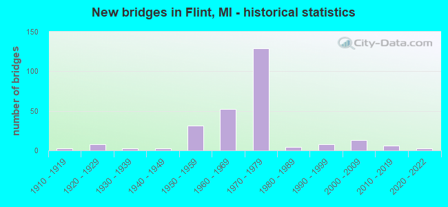
- New bridges - historical statistics
- 11900-1909
- 31910-1919
- 81920-1929
- 31930-1939
- 31940-1949
- 311950-1959
- 521960-1969
- 1291970-1979
- 41980-1989
- 81990-1999
- 132000-2009
- 62010-2019
- 32020-2022
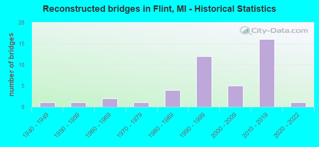
- Reconstructed bridges - Historical Statistics
- 11940-1949
- 11950-1959
- 21960-1969
- 11970-1979
- 41980-1989
- 121990-1999
- 52000-2009
- 162010-2019
- 12020-2022
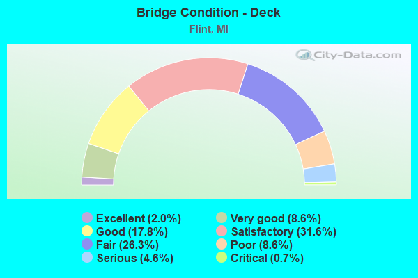
- Bridge Condition - Deck
- 2.0%Excellent
- 8.6%Very good
- 17.8%Good
- 31.6%Satisfactory
- 26.3%Fair
- 8.6%Poor
- 4.6%Serious
- 0.7%Critical
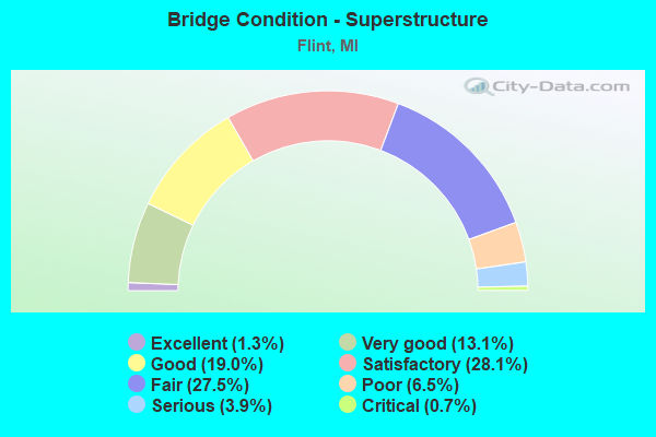
- Bridge Condition - Superstructure
- 1.3%Excellent
- 13.1%Very good
- 19.0%Good
- 28.1%Satisfactory
- 27.5%Fair
- 6.5%Poor
- 3.9%Serious
- 0.7%Critical
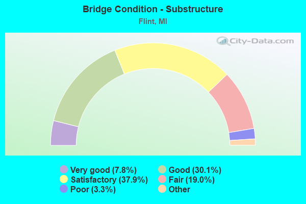
- Bridge Condition - Substructure
- 7.8%Excellent
- 30.1%Very good
- 37.9%Good
- 19.0%Satisfactory
- 3.3%Fair
- 2.0%Poor
- 0.7%Serious
- 0.7%Critical
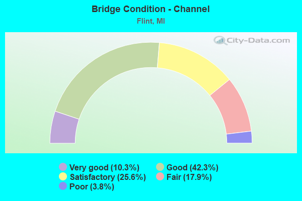
- Bridge Condition - Channel
- 10.3%Very good
- 42.3%Good
- 25.6%Satisfactory
- 17.9%Fair
- 3.8%Poor
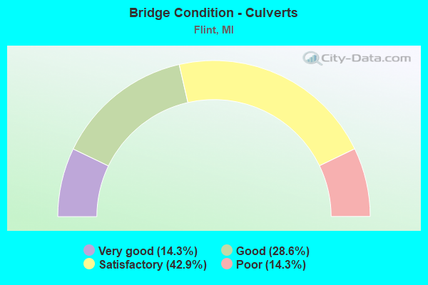
- Bridge Condition - Culverts
- 14.3%Very good
- 28.6%Good
- 42.9%Satisfactory
- 14.3%Poor
Find on map >> Show street view
Structure Number: 2607, Location: IN FLINT (Lat: 43.007853, Lng: -83.684858), Route carried "under" structure: Interstate 69, Year Built: 1970, Structure Length: 0. m, Average Daily Traffic: 82,100 (year 2011), Truck Traffic: 8%, Features Intersected: I-69, Facility Carried by Structure: BEACH ST (OLDM-56)
Minimum Vertical Clearance: 4.67m (15.32ft), Kilometerpoint: 21.345, Lanes on structure: 4, Lanes under structure: 8, Material/Design: Steel, Design/Construction: Stringer/Multi-beam, Length of Maximum Span: 33.3m (109.3ft)
Find on map >> Show street view
Structure Number: 2608, Location: IN FLINT (Lat: 43.008547, Lng: -83.683600), Route carried "under" structure: Interstate 69, Year Built: 1970, Structure Length: 0. m, Average Daily Traffic: 82,100 (year 2011), Truck Traffic: 8%, Features Intersected: I-69, Facility Carried by Structure: SAGINAW ST
Minimum Vertical Clearance: 4.62m (15.16ft), Kilometerpoint: 21.474, Lanes on structure: 4, Lanes under structure: 10, Material/Design: Steel, Design/Construction: Stringer/Multi-beam, Length of Maximum Span: 43.0m (141.1ft)
Find on map >> Show street view
Structure Number: 2632, Location: 1.2 MI SE OF US-23 (Lat: 42.944192, Lng: -83.712939), Route carried "under" structure: Interstate 75, Year Built: 1962, Structure Length: 0. m, Average Daily Traffic: 34,200 (year 2007), Truck Traffic: 9%, Features Intersected: I-75, Facility Carried by Structure: HILL RD
Minimum Vertical Clearance: 5.05m (16.57ft), Kilometerpoint: 12.684, Lanes on structure: 4, Lanes under structure: 6, Material/Design: Prestressed concrete, Design/Construction: Box Beam or Girders - Single/Spread, Length of Maximum Span: 29.8m (97.8ft)
Find on map >> Show street view
Structure Number: 2633, Location: 1.6 MI SE OF M-121 (Lat: 42.951428, Lng: -83.722958), Route carried "under" structure: US 23, Year Built: 1962, Structure Length: 0. m, Average Daily Traffic: 27,962 (year 2007), Truck Traffic: 9%, Features Intersected: US-23 NB, Facility Carried by Structure: I-75 SB
Minimum Vertical Clearance: 4.95m (16.24ft), Kilometerpoint: 19.712, Lanes on structure: 2, Lanes under structure: 3, Material/Design: Steel, Design/Construction: Stringer/Multi-beam, Length of Maximum Span: 35.6m (116.8ft)
Find on map >> Show street view
Structure Number: 2637, Location: IN FLINT (Lat: 43.038486, Lng: -83.676839), Route carried "under" structure: City street , Year Built: 1976, Structure Length: 0. m, Average Daily Traffic: 2,200 (year 1988), Features Intersected: FLINT R,W BLVD&R SIDE DR, Facility Carried by Structure: I-475
Minimum Vertical Clearance: 5.23m (17.16ft), Kilometerpoint: 0.079, Lanes on structure: 6, Lanes under structure: 4, Material/Design: Steel, Design/Construction: Stringer/Multi-beam, Length of Maximum Span: 37.5m (123.0ft)
Find on map >> Show street view
Structure Number: 2641, Location: IN FLINT (Lat: 43.021892, Lng: -83.683125), Route carried "under" structure: Interstate 475, Year Built: 1976, Structure Length: 0. m, Average Daily Traffic: 72,100 (year 2007), Truck Traffic: 2%, Features Intersected: I-475, Facility Carried by Structure: AVON ST WALKOVER
Minimum Vertical Clearance: 7.42m (24.34ft), Kilometerpoint: 11.831, Lanes under structure: 13, Material/Design: Steel, Design/Construction: Stringer/Multi-beam, Length of Maximum Span: 28.0m (91.9ft)
Find on map >> Show street view
Structure Number: 2644, Location: IN FLINT (Lat: 42.997967, Lng: -83.675044), Route carried "under" structure: Interstate 475, Year Built: 1971, Structure Length: 0. m, Average Daily Traffic: 59,000 (year 2007), Truck Traffic: 4%, Features Intersected: I-475, Facility Carried by Structure: LINDSAY BLVD PED-X
Minimum Vertical Clearance: 4.93m (16.17ft), Kilometerpoint: 8.982, Lanes under structure: 6, Material/Design: Steel, Design/Construction: Stringer/Multi-beam, Length of Maximum Span: 24.7m (81.0ft)
Find on map >> Show street view
Structure Number: 2645, Location: IN FLINT (Lat: 42.993156, Lng: -83.680367), Route carried "under" structure: City street , Year Built: 1971, Structure Length: 0. m, Average Daily Traffic: 550 (year 1988), Features Intersected: CSX RR & NB SERV RD(ABN), Facility Carried by Structure: I-475
Minimum Vertical Clearance: 6.57m (21.56ft), Kilometerpoint: 2.073, Lanes on structure: 8, Lanes under structure: 2, Material/Design: Steel, Design/Construction: Stringer/Multi-beam, Length of Maximum Span: 45.4m (149.0ft)
Find on map >> Show street view
Structure Number: 2647, Location: IN CITY OF FLINT (Lat: 43.061331, Lng: -83.677314), Route carried "under" structure: City street , Year Built: 1976, Structure Length: 0. m, Average Daily Traffic: 23,700 (year 1990), Truck Traffic: 8%, Features Intersected: CSX RR AND PIERSON RD, Facility Carried by Structure: I-475
Minimum Vertical Clearance: 6.10m (20.01ft), Kilometerpoint: 0.988, Lanes on structure: 6, Lanes under structure: 4, Material/Design: Steel, Design/Construction: Stringer/Multi-beam, Length of Maximum Span: 45.7m (149.9ft)
Find on map >> Show street view
Structure Number: 2653, Location: IN FLINT (Lat: 42.988867, Lng: -83.682442), Route carried "under" structure: City street 2002, Year Built: 1971, Structure Length: 0. m, Average Daily Traffic: 19,046 (year 1995), Truck Traffic: 6%, Features Intersected: ATHERTON RD, Facility Carried by Structure: I-475
Minimum Vertical Clearance: 4.62m (15.16ft), Kilometerpoint: 2.517, Lanes on structure: 6, Lanes under structure: 4, Material/Design: Prestressed concrete, Design/Construction: Stringer/Multi-beam, Length of Maximum Span: 18.7m (61.4ft)
Find on map >> Show street view
Structure Number: 2654, Location: IN FLINT (Lat: 42.995033, Lng: -83.677511), Route carried "under" structure: Business State highway 54, Year Built: 1971, Structure Length: 0. m, Average Daily Traffic: 47,000 (year 1995), Truck Traffic: 5%, Features Intersected: M-54 BR (SAGINAW ST), Facility Carried by Structure: I-475
Minimum Vertical Clearance: 4.78m (15.68ft), Kilometerpoint: 15.756, Lanes on structure: 4, Lanes under structure: 4, Material/Design: Steel, Design/Construction: Stringer/Multi-beam, Length of Maximum Span: 27.4m (89.9ft)
Find on map >> Show street view
Structure Number: 2655, Location: IN FLINT (Lat: 43.006950, Lng: -83.677628), Route carried "under" structure: Interstate 475, Year Built: 1970, Structure Length: 0. m, Average Daily Traffic: 59,000 (year 2007), Truck Traffic: 4%, Features Intersected: I-475, Facility Carried by Structure: 12TH ST
Minimum Vertical Clearance: 5.00m (16.40ft), Kilometerpoint: 10.009, Lanes on structure: 4, Lanes under structure: 9, Material/Design: Steel, Design/Construction: Stringer/Multi-beam, Length of Maximum Span: 37.5m (123.0ft)
Find on map >> Show street view
Structure Number: 2656, Location: IN FLINT LVL 2 (Lat: 43.010253, Lng: -83.679314), Route carried "under" structure: Interstate 475, Year Built: 1970, Structure Length: 0. m, Average Daily Traffic: 47,700 (year 2012), Truck Traffic: 2%, Features Intersected: I-475 & I-475 RAMPS, Facility Carried by Structure: I-69 EB
Minimum Vertical Clearance: 4.93m (16.17ft), Kilometerpoint: 10.402, Lanes on structure: 3, Lanes under structure: 6, Material/Design: Steel, Design/Construction: Stringer/Multi-beam, Length of Maximum Span: 30.4m (99.7ft)
Find on map >> Show street view
Structure Number: 2657, Location: IN FLINT LVL 2 (Lat: 43.010469, Lng: -83.679378), Route carried "under" structure: Interstate 475, Year Built: 1970, Structure Length: 0. m, Average Daily Traffic: 45,500 (year 2022), Truck Traffic: 5%, Features Intersected: I-475 & I-475 RAMPS, Facility Carried by Structure: I-69 WB
Minimum Vertical Clearance: 5.51m (18.08ft), Kilometerpoint: 10.426, Lanes on structure: 3, Lanes under structure: 6, Material/Design: Steel, Design/Construction: Stringer/Multi-beam, Length of Maximum Span: 29.8m (97.8ft)
Find on map >> Show street view
Structure Number: 2658, Location: IN FLINT (Lat: 43.010542, Lng: -83.679397), Route carried "under" structure: Interstate 69, Year Built: 1970, Structure Length: 0. m, Average Daily Traffic: 53,938 (year 2007), Truck Traffic: 14%, Features Intersected: I-475 & I-69, Facility Carried by Structure: I-475 RAMP E
Minimum Vertical Clearance: 4.93m (16.17ft), Kilometerpoint: 21.849, Lanes on structure: 1, Lanes under structure: 6, Material/Design: Steel continuous, Design/Construction: Stringer/Multi-beam, Length of Maximum Span: 45.7m (149.9ft)
Find on map >> Show street view
Structure Number: 2659, Location: IN FLINT (Lat: 43.010486, Lng: -83.679292), Route carried "under" structure: Interstate 69, Year Built: 1970, Structure Length: 0. m, Average Daily Traffic: 59,000 (year 2007), Truck Traffic: 4%, Features Intersected: I-69 & I-475, Facility Carried by Structure: I-475 RAMP F
Minimum Vertical Clearance: 5.31m (17.42ft), Kilometerpoint: 10.419, Lanes on structure: 1, Lanes under structure: 6, Material/Design: Steel continuous, Design/Construction: Stringer/Multi-beam, Length of Maximum Span: 45.7m (149.9ft)
Find on map >> Show street view
Structure Number: 266, Location: IN FLINT (Lat: 43.010267, Lng: -83.679236), Route carried "under" structure: Interstate 69, Year Built: 1970, Structure Length: 0. m, Average Daily Traffic: 95,314 (year 2007), Truck Traffic: 6%, Features Intersected: I-475RMPS E&F,I-69&475, Facility Carried by Structure: I-475 RAMPS G & H
Minimum Vertical Clearance: 4.50m (14.76ft), Kilometerpoint: 21.886, Lanes on structure: 4, Lanes under structure: 4, Material/Design: Steel continuous, Design/Construction: Stringer/Multi-beam, Length of Maximum Span: 47.2m (154.9ft)
Find on map >> Show street view
Structure Number: 2661, Location: IN FLINT (Lat: 43.008869, Lng: -83.682542), Route carried "under" structure: Ramp Interstate 69, Year Built: 1970, Structure Length: 0. m, Average Daily Traffic: 56,400 (year 1988), Truck Traffic: 4%, Features Intersected: I-69 & I-475 RAMP A
Minimum Vertical Clearance: 4.70m (15.42ft), Kilometerpoint: 0.261, Lanes on structure: 2, Lanes under structure: 2, Material/Design: Steel, Design/Construction: Stringer/Multi-beam, Length of Maximum Span: 40.5m (132.9ft)
Find on map >> Show street view
Structure Number: 2662, Location: IN FLINT (Lat: 43.009806, Lng: -83.683247), Route carried "under" structure: Ramp Interstate 475, Year Built: 1970, Structure Length: 0. m, Average Daily Traffic: 14,400 (year 1988), Features Intersected: I-475 RAMP D, Facility Carried by Structure: 8TH ST SERVICE RD
Minimum Vertical Clearance: 4.70m (15.42ft), Kilometerpoint: 0.578, Lanes on structure: 3, Lanes under structure: 2, Material/Design: Steel, Design/Construction: Stringer/Multi-beam, Length of Maximum Span: 31.9m (104.7ft)
Find on map >> Show street view
Structure Number: 2663, Location: IN FLINT (Lat: 43.013150, Lng: -83.681897), Route carried "under" structure: Ramp Interstate 475, Year Built: 1970, Structure Length: 0. m, Average Daily Traffic: 56,400 (year 1988), Features Intersected: RAMP D I-69&I475 INTERCH, Facility Carried by Structure: S B SERVICE RD
Minimum Vertical Clearance: 4.52m (14.83ft), Kilometerpoint: 0.183, Lanes on structure: 2, Lanes under structure: 2, Material/Design: Steel, Design/Construction: Stringer/Multi-beam, Length of Maximum Span: 39.0m (128.0ft)
Find on map >> Show street view
Structure Number: 2664, Location: IN FLINT (Lat: 43.013647, Lng: -83.680914), Route carried "under" structure: Ramp Interstate 475, Year Built: 1970, Structure Length: 0. m, Average Daily Traffic: 56,400 (year 1988), Features Intersected: I-475S ON RMP C
Minimum Vertical Clearance: 4.40m (14.44ft), Kilometerpoint: 0.906, Lanes on structure: 3, Lanes under structure: 2, Material/Design: Steel, Design/Construction: Stringer/Multi-beam, Length of Maximum Span: 41.7m (136.8ft)
Find on map >> Show street view
Structure Number: 2665, Location: IN FLINT (Lat: 43.014144, Lng: -83.681594), Route carried "under" structure: Interstate 475, Year Built: 1970, Structure Length: 0. m, Average Daily Traffic: 72,100 (year 2007), Truck Traffic: 2%, Features Intersected: I-475 & RAMPS C&D, Facility Carried by Structure: FIFTH ST, M-21
Minimum Vertical Clearance: 4.90m (16.08ft), Kilometerpoint: 10.870, Lanes on structure: 4, Lanes under structure: 8, Material/Design: Steel, Design/Construction: Stringer/Multi-beam, Length of Maximum Span: 37.2m (122.0ft)
Find on map >> Show street view
Structure Number: 2666, Location: IN FLINT (Lat: 43.015050, Lng: -83.682347), Route carried "under" structure: Interstate 475, Year Built: 1970, Structure Length: 0. m, Average Daily Traffic: 72,100 (year 2007), Truck Traffic: 2%, Features Intersected: I-475, Facility Carried by Structure: COURT ST - WB
Minimum Vertical Clearance: 4.82m (15.81ft), Kilometerpoint: 10.991, Lanes on structure: 4, Lanes under structure: 9, Material/Design: Steel, Design/Construction: Stringer/Multi-beam, Length of Maximum Span: 26.5m (86.9ft)
Find on map >> Show street view
Structure Number: 2667, Location: IN FLINT (Lat: 43.016614, Lng: -83.683519), Route carried "under" structure: Interstate 475, Year Built: 1976, Structure Length: 0. m, Average Daily Traffic: 72,100 (year 2007), Truck Traffic: 2%, Features Intersected: I-475, Facility Carried by Structure: THIRD ST
Minimum Vertical Clearance: 4.75m (15.58ft), Kilometerpoint: 11.189, Lanes on structure: 2, Lanes under structure: 6, Material/Design: Steel, Design/Construction: Stringer/Multi-beam, Length of Maximum Span: 24.9m (81.7ft)
Find on map >> Show street view
Structure Number: 2668, Location: IN FLINT (Lat: 43.017594, Lng: -83.684158), Route carried "under" structure: Interstate 475, Year Built: 1976, Structure Length: 0. m, Average Daily Traffic: 72,100 (year 2007), Truck Traffic: 2%, Features Intersected: I-475, Facility Carried by Structure: SECOND ST
Minimum Vertical Clearance: 5.66m (18.57ft), Kilometerpoint: 11.309, Lanes on structure: 3, Lanes under structure: 6, Material/Design: Steel, Design/Construction: Stringer/Multi-beam, Length of Maximum Span: 26.2m (86.0ft)
Find on map >> Show street view
Structure Number: 2669, Location: IN FLINT (Lat: 43.020058, Lng: -83.684425), Route carried "under" structure: Interstate 475, Year Built: 1976, Structure Length: 0. m, Average Daily Traffic: 72,100 (year 2007), Truck Traffic: 2%, Features Intersected: I-475, Facility Carried by Structure: KEARSLEY ST
Minimum Vertical Clearance: 6.25m (20.51ft), Kilometerpoint: 11.580, Lanes on structure: 4, Lanes under structure: 8, Material/Design: Steel, Design/Construction: Stringer/Multi-beam, Length of Maximum Span: 39.3m (128.9ft)
Find on map >> Show street view
Structure Number: 267, Location: IN FLINT (Lat: 43.024900, Lng: -83.681500), Route carried "under" structure: Interstate 475, Year Built: 1976, Structure Length: 0. m, Average Daily Traffic: 72,100 (year 2007), Truck Traffic: 2%, Features Intersected: I-475, Facility Carried by Structure: E BD LONGWAY BLVD
Minimum Vertical Clearance: 4.93m (16.17ft), Kilometerpoint: 12.277, Lanes on structure: 4, Lanes under structure: 6, Material/Design: Steel, Design/Construction: Stringer/Multi-beam, Length of Maximum Span: 30.8m (101.0ft)
Find on map >> Show street view
Structure Number: 2671, Location: IN FLINT (Lat: 43.025600, Lng: -83.681000), Route carried "under" structure: Interstate 475, Year Built: 1976, Structure Length: 0. m, Average Daily Traffic: 72,100 (year 2007), Truck Traffic: 2%, Features Intersected: I-475, Facility Carried by Structure: W BD LONGWAY BLVD
Minimum Vertical Clearance: 4.67m (15.32ft), Kilometerpoint: 12.199, Lanes on structure: 4, Lanes under structure: 6, Material/Design: Steel, Design/Construction: Stringer/Multi-beam, Length of Maximum Span: 25.4m (83.3ft)
Find on map >> Show street view
Structure Number: 2672, Location: IN FLINT (Lat: 43.031714, Lng: -83.677072), Route carried "under" structure: City street 25, Year Built: 1976, Structure Length: 0. m, Average Daily Traffic: 4,400 (year 1988), Features Intersected: CHAVEZ DR, Facility Carried by Structure: I-475 AND RAMP B
Minimum Vertical Clearance: 4.82m (15.81ft), Kilometerpoint: 2.092, Lanes on structure: 4, Lanes under structure: 2, Material/Design: Steel, Design/Construction: Stringer/Multi-beam, Length of Maximum Span: 23.1m (75.8ft)
Find on map >> Show street view
Structure Number: 2673, Location: IN FLINT (Lat: 43.034172, Lng: -83.676689), Route carried "under" structure: City street 2002, Year Built: 1976, Structure Length: 0. m, Average Daily Traffic: 14,300 (year 1988), Features Intersected: DAVISON - BROADWAY AVES, Facility Carried by Structure: I-475
Minimum Vertical Clearance: 5.16m (16.93ft), Kilometerpoint: 3.629, Lanes on structure: 6, Lanes under structure: 4, Material/Design: Steel, Design/Construction: Stringer/Multi-beam, Length of Maximum Span: 24.0m (78.7ft)
Find on map >> Show street view
Structure Number: 2674, Location: IN CITY OF FLINT (Lat: 43.042889, Lng: -83.676317), Route carried "under" structure: City street 2002, Year Built: 1977, Structure Length: 0. m, Average Daily Traffic: 3,878 (year 1995), Truck Traffic: 4%, Features Intersected: LEITH STREET, Facility Carried by Structure: I-475
Minimum Vertical Clearance: 4.50m (14.76ft), Kilometerpoint: 0.064, Lanes on structure: 6, Lanes under structure: 4, Material/Design: Steel, Design/Construction: Stringer/Multi-beam, Length of Maximum Span: 24.3m (79.7ft)
Find on map >> Show street view
Structure Number: 2675, Location: IN FLINT (Lat: 43.054089, Lng: -83.673639), Route carried "under" structure: City street 2002, Year Built: 1978, Structure Length: 0. m, Average Daily Traffic: 21,500 (year 1996), Truck Traffic: 7%, Features Intersected: STEWART AVE, Facility Carried by Structure: I-475
Minimum Vertical Clearance: 4.65m (15.26ft), Kilometerpoint: 1.645, Lanes on structure: 6, Lanes under structure: 6, Material/Design: Steel, Design/Construction: Stringer/Multi-beam, Length of Maximum Span: 28.9m (94.8ft)
Find on map >> Show street view
Structure Number: 2676, Location: IN FLINT (Lat: 43.057914, Lng: -83.674361), Route carried "under" structure: Ramp Interstate 475, Year Built: 1978, Structure Length: 0. m, Average Daily Traffic: 3,000 (year 0000), Features Intersected: RAMP C I-475
Minimum Vertical Clearance: 4.50m (14.76ft), Kilometerpoint: 0.187, Lanes on structure: 8, Lanes under structure: 1, Material/Design: Steel, Design/Construction: Stringer/Multi-beam, Length of Maximum Span: 23.1m (75.8ft)
Find on map >> Show street view
Structure Number: 2677, Location: IN FLINT (Lat: 43.064886, Lng: -83.681583), Route carried "under" structure: City street 2002, Year Built: 1977, Structure Length: 0. m, Average Daily Traffic: 5,564 (year 1996), Truck Traffic: 2%, Features Intersected: HORTON AVE, Facility Carried by Structure: I-475
Minimum Vertical Clearance: 4.72m (15.49ft), Kilometerpoint: 0.837, Lanes on structure: 6, Lanes under structure: 2, Material/Design: Steel, Design/Construction: Stringer/Multi-beam, Length of Maximum Span: 20.7m (67.9ft)
Find on map >> Show street view
Structure Number: 2678, Location: AT N LIMITS OF FLINT (Lat: 43.075792, Lng: -83.683517), Route carried "under" structure: Interstate 475, Year Built: 1978, Structure Length: 0. m, Average Daily Traffic: 41,600 (year 2007), Truck Traffic: 7%, Features Intersected: I-475, Facility Carried by Structure: CARPENTER ROAD
Minimum Vertical Clearance: 4.82m (15.81ft), Kilometerpoint: 18.202, Lanes on structure: 5, Lanes under structure: 7, Material/Design: Steel, Design/Construction: Stringer/Multi-beam, Length of Maximum Span: 24.9m (81.7ft)
Find on map >> Show street view
Structure Number: 2688, Location: AT S LIMITS OF FLINT (Lat: 42.980458, Lng: -83.682067), Route carried "under" structure: Interstate 475, Year Built: 1971, Structure Length: 0. m, Average Daily Traffic: 30,200 (year 2007), Truck Traffic: 7%, Features Intersected: I-475, Facility Carried by Structure: LEFT TURN LANE NO1
Minimum Vertical Clearance: 4.83m (15.85ft), Kilometerpoint: 6.827, Lanes on structure: 1, Lanes under structure: 4, Material/Design: Steel continuous, Design/Construction: Stringer/Multi-beam, Length of Maximum Span: 21.3m (69.9ft)
Find on map >> Show street view
Structure Number: 2689, Location: AT S LIMITS OF FLINT (Lat: 42.982125, Lng: -83.682117), Route carried "under" structure: Interstate 475, Year Built: 1971, Structure Length: 0. m, Average Daily Traffic: 48,400 (year 2007), Truck Traffic: 6%, Features Intersected: I-475, Facility Carried by Structure: LEFT TURN LANE NO2
Minimum Vertical Clearance: 4.50m (14.76ft), Kilometerpoint: 7.012, Lanes on structure: 1, Lanes under structure: 4, Material/Design: Steel continuous, Design/Construction: Stringer/Multi-beam, Length of Maximum Span: 21.3m (69.9ft)
Find on map >> Show street view
Structure Number: 269, Location: IN FLINT (Lat: 42.987786, Lng: -83.682414), Route carried "under" structure: City street 25, Year Built: 1971, Structure Length: 0. m, Average Daily Traffic: 2,200 (year 1988), Features Intersected: LEFT TURN LANE NO 3, Facility Carried by Structure: I-475
Minimum Vertical Clearance: 4.52m (14.83ft), Kilometerpoint: 0.061, Lanes on structure: 6, Lanes under structure: 1, Material/Design: Prestressed concrete, Design/Construction: Stringer/Multi-beam, Length of Maximum Span: 12.0m (39.4ft)
Find on map >> Show street view
Structure Number: 2693, Location: IN FLINT (Lat: 43.065258, Lng: -83.681383), Route carried "under" structure: City street 2002, Year Built: 1977, Structure Length: 0. m, Average Daily Traffic: 5,564 (year 1996), Truck Traffic: 2%, Features Intersected: HORTON AVE, Facility Carried by Structure: I-475 RAMP
Minimum Vertical Clearance: 4.65m (15.26ft), Kilometerpoint: 0.882, Lanes on structure: 1, Lanes under structure: 2, Material/Design: Steel, Design/Construction: Stringer/Multi-beam, Length of Maximum Span: 27.0m (88.6ft)
Find on map >> Show street view
Structure Number: 2694, Location: IN FLINT (Lat: 43.067072, Lng: -83.682972), Route carried "under" structure: Interstate 475, Year Built: 1977, Structure Length: 0. m, Average Daily Traffic: 41,600 (year 2007), Truck Traffic: 5%, Features Intersected: I-475
Minimum Vertical Clearance: 4.85m (15.91ft), Kilometerpoint: 17.229, Lanes on structure: 1, Lanes under structure: 6, Material/Design: Steel, Design/Construction: Stringer/Multi-beam, Length of Maximum Span: 25.6m (84.0ft)
Find on map >> Show street view
Structure Number: 2695, Location: IN FLINT (Lat: 43.072539, Lng: -83.684194), Route carried "under" structure: Ramp Interstate 475, Year Built: 1977, Structure Length: 0. m, Average Daily Traffic: 3,000 (year 0000), Truck Traffic: 3%, Features Intersected: SELBY TO I-475 SB ON RP
Minimum Vertical Clearance: 4.80m (15.75ft), Kilometerpoint: 0.233, Lanes on structure: 1, Lanes under structure: 1, Material/Design: Steel, Design/Construction: Stringer/Multi-beam, Length of Maximum Span: 44.8m (147.0ft)
Find on map >> Show street view
Structure Number: 2696, Location: IN FLINT (Lat: 43.072253, Lng: -83.683075), Route carried "under" structure: Ramp Interstate 475, Year Built: 1977, Structure Length: 0. m, Average Daily Traffic: 3,000 (year 0000), Features Intersected: RAMP F I-475
Minimum Vertical Clearance: 4.57m (14.99ft), Kilometerpoint: 0.172, Lanes on structure: 1, Lanes under structure: 1, Material/Design: Steel, Design/Construction: Stringer/Multi-beam, Length of Maximum Span: 40.8m (133.9ft)
Find on map >> Show street view
Structure Number: 2698, Location: IN FLINT (Lat: 43.047178, Lng: -83.674450), Route carried "under" structure: City street 2002, Year Built: 1978, Structure Length: 0. m, Average Daily Traffic: 2,500 (year 0000), Features Intersected: MASSACHUSETTS AVE., Facility Carried by Structure: I-475
Minimum Vertical Clearance: 4.34m (14.24ft), Kilometerpoint: 0.507, Lanes on structure: 6, Lanes under structure: 2, Material/Design: Steel, Design/Construction: Stringer/Multi-beam, Length of Maximum Span: 15.2m (49.9ft)
Find on map >> Show street view
Structure Number: 2699, Location: IN FLINT (Lat: 43.068856, Lng: -83.683419), Route carried "under" structure: Interstate 475, Year Built: 1977, Structure Length: 0. m, Average Daily Traffic: 41,600 (year 2007), Truck Traffic: 5%, Features Intersected: I-475, Facility Carried by Structure: RUSSELL AVE
Minimum Vertical Clearance: 4.57m (14.99ft), Kilometerpoint: 17.431, Lanes on structure: 2, Lanes under structure: 6, Material/Design: Steel, Design/Construction: Stringer/Multi-beam, Length of Maximum Span: 24.8m (81.4ft)
Find on map >> Show street view
Structure Number: 27, Location: IN FLINT (Lat: 43.005350, Lng: -83.677139), Route carried "under" structure: Interstate 475, Year Built: 1971, Structure Length: 0. m, Average Daily Traffic: 59,000 (year 2007), Truck Traffic: 4%, Features Intersected: I-475, Facility Carried by Structure: 14TH ST
Minimum Vertical Clearance: 5.66m (18.57ft), Kilometerpoint: 9.829, Lanes on structure: 2, Lanes under structure: 8, Material/Design: Steel, Design/Construction: Stringer/Multi-beam, Length of Maximum Span: 24.2m (79.4ft)
Find on map >> Show street view
Structure Number: 2701, Location: IN FLINT (Lat: 43.004789, Lng: -83.676908), Route carried "under" structure: Interstate 475, Year Built: 1970, Structure Length: 0. m, Average Daily Traffic: 72,100 (year 2007), Truck Traffic: 2%, Features Intersected: I-475, Facility Carried by Structure: GTW RR
Minimum Vertical Clearance: 4.60m (15.09ft), Kilometerpoint: 22.503, Lanes under structure: 6, Material/Design: Steel, Design/Construction: Stringer/Multi-beam, Length of Maximum Span: 24.0m (78.7ft)
Find on map >> Show street view
Structure Number: 2741, Location: BET BRISTOL & MAPLE (Lat: 42.969353, Lng: -83.771814), Route carried "under" structure: County highway 732, Year Built: 1936, Structure Length: 0. m, Average Daily Traffic: 16,300 (year 2004), Truck Traffic: 5%, Features Intersected: LINDEN ROAD, Facility Carried by Structure: GRAND TRUNK R/R
Minimum Vertical Clearance: 4.22m (13.85ft), Kilometerpoint: 21.872, Lanes under structure: 4, Material/Design: Steel, Design/Construction: Stringer/Multi-beam, Length of Maximum Span: 15.5m (50.9ft)
Find on map >> Show street view
Structure Number: 2836, Location: IN FLINT (Lat: 43.042914, Lng: -83.675267), Route carried "under" structure: City street , Year Built: 1967, Structure Length: 0. m, Average Daily Traffic: 100 (year 1994), Features Intersected: W BOULEVARD; FLINT RIVER, Facility Carried by Structure: LEITH STREET
Minimum Vertical Clearance: 3.89m (12.76ft), Kilometerpoint: 0.481, Lanes on structure: 4, Lanes under structure: 2, Material/Design: Concrete, Design/Construction: Arch - Deck, Length of Maximum Span: 25.9m (85.0ft)
Find on map >> Show street view
Structure Number: 2859, Location: IN FLINT (Lat: 43.056742, Lng: -83.666217), Route carried "under" structure: City street 25, Year Built: 1900, Structure Length: 0. m, Average Daily Traffic: 1,420 (year 1976), Features Intersected: FLINT RIVER & EAST BLVD, Facility Carried by Structure: CSX RR
Minimum Vertical Clearance: 3.91m (12.83ft), Kilometerpoint: 0.459, Lanes under structure: 2, Material/Design: Wood or Timber, Design/Construction: Frame, Length of Maximum Span: 21.3m (69.9ft)
Find on map >> Show street view
Structure Number: 14476, Location: IN FLINT (FENTON RD) (Lat: 42.998969, Lng: -83.693100), Route carried "under" structure: City street , Structure Length: 0. m, Features Intersected: FENTON RD, Facility Carried by Structure: GTW RR
Minimum Vertical Clearance: 30+ m (98+ ft), Kilometerpoint: 21.027, Lanes under structure: 2, Material/Design: Steel, Design/Construction: Stringer/Multi-beam, Length of Maximum Span: 7.2m (23.6ft)
Find on map >> Show street view
Structure Number: 14477, Location: IN FLINT (GRAND TRAVERSE) (Lat: 43.002336, Lng: -83.683811), Route carried "under" structure: City street , Structure Length: 0. m, Features Intersected: GRAND TRAVERSE ST, Facility Carried by Structure: GTW RR
Minimum Vertical Clearance: 30+ m (98+ ft), Kilometerpoint: 21.878, Lanes under structure: 4, Material/Design: Steel, Design/Construction: Stringer/Multi-beam, Length of Maximum Span: 19.8m (65.0ft)