Bridge Statistics for Fort Wayne, Indiana (IN)
Condition, Traffic, Stress, Structural Evaluation, Project Costs
- National Bridge Inventory (NBI) Statistics
- 400Number of bridges
- 3,579ft / 1,091mTotal length
- $63,291,000Total costs
- 5,122,064Total average daily traffic
- 747,105Total average daily truck traffic
- National Bridge Inventory (NBI) Registered Bridges for Fort Wayne
- No street view available for this location
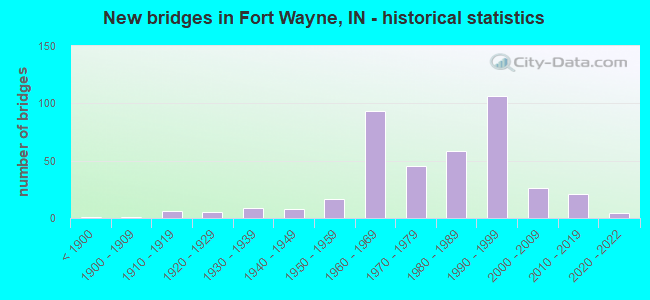
- New bridges - historical statistics
- 1Before 1900
- 11900-1909
- 61910-1919
- 51920-1929
- 91930-1939
- 81940-1949
- 171950-1959
- 931960-1969
- 451970-1979
- 581980-1989
- 1061990-1999
- 262000-2009
- 212010-2019
- 42020-2022
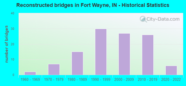
- Reconstructed bridges - Historical Statistics
- 21960-1969
- 71970-1979
- 151980-1989
- 301990-1999
- 272000-2009
- 262010-2019
- 62020-2022
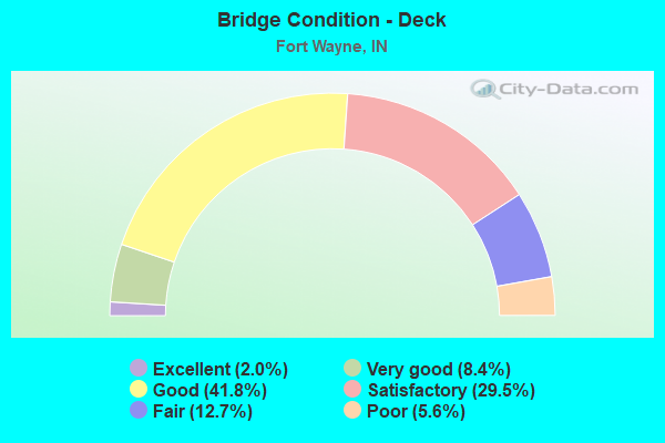
- Bridge Condition - Deck
- 2.0%Excellent
- 8.4%Very good
- 41.8%Good
- 29.5%Satisfactory
- 12.7%Fair
- 5.6%Poor
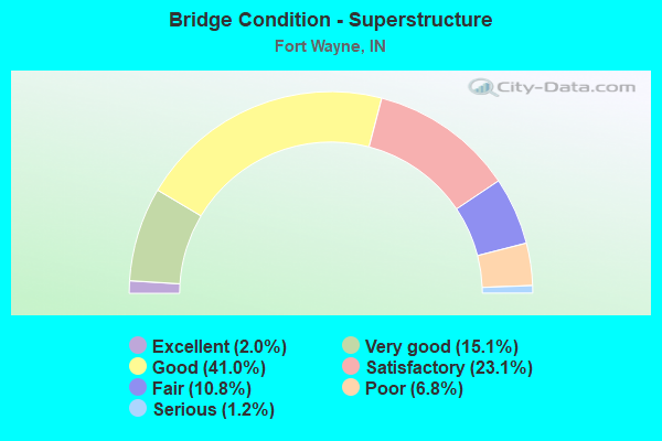
- Bridge Condition - Superstructure
- 2.0%Excellent
- 15.1%Very good
- 41.0%Good
- 23.1%Satisfactory
- 10.8%Fair
- 6.8%Poor
- 1.2%Serious
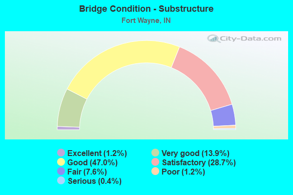
- Bridge Condition - Substructure
- 1.2%Excellent
- 13.9%Very good
- 47.0%Good
- 28.7%Satisfactory
- 7.6%Fair
- 1.2%Poor
- 0.4%Serious
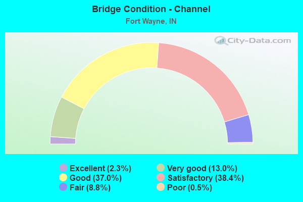
- Bridge Condition - Channel
- 2.3%Excellent
- 13.0%Very good
- 37.0%Good
- 38.4%Satisfactory
- 8.8%Fair
- 0.5%Poor
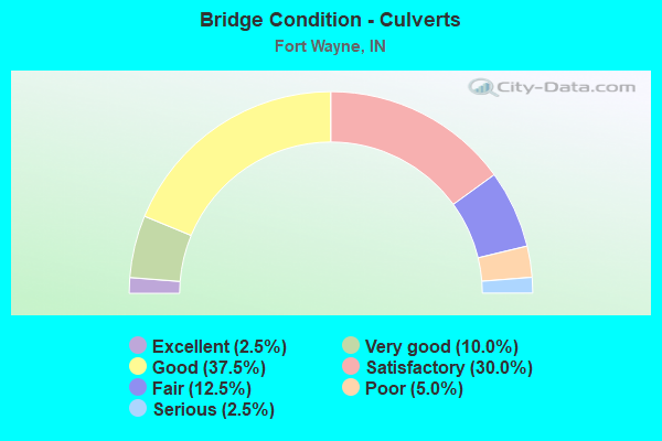
- Bridge Condition - Culverts
- 2.5%Excellent
- 10.0%Very good
- 37.5%Good
- 30.0%Satisfactory
- 12.5%Fair
- 5.0%Poor
- 2.5%Serious
Find on map >> Show street view
Structure Number: 4, Location: 01.18 S I-469 (Lat: 40.937100, Lng: -85.167431), Route carried "on" structure: State highway 1, Year Built: 1984, Year Reconstructed: 2016, Status: Open, Structure Length: 2.19m (7.19ft), Average Daily Traffic: 11,531 (year 2019), Truck Traffic: 5%, Average Future Daily Traffic: 16,432 (year 2034), Design Load: HS 20, Features Intersected: DEPTMER DITCH
Minimum Vertical Clearance: 30+ m (98+ ft), Kilometerpoint: 2.269, Lanes on structure: 2, Owner: State Highway Agency, Approaching Roadway Width: 13.3m (43.6ft), Skew: 1 degrees, Material/Design: Concrete continuous, Design/Construction: Slab, Number Of Spans In Main Unit: 3, Length of Maximum Span: 8.2m (26.9ft), Curb-To-Curb Width: 13.3m (43.6ft), Out-to-Out Width: 14.2m (46.6ft)
Condition: Deck: Good, Superstructure: Good, Substructure: Good, Channel: Very good, Operating Rating: 39.5 metric tons, Method Used To Determine Operating Rating: Load and Resistance Factor Rating (LRFR) rating reported by rating factor(RF) method using HL-93 loadings, Inventory Rating: 30.5 metric tons, Method Used To Determine Inventory Rating: Load and Resistance Factor Rating (LRFR) rating reported by rating factor(RF) method using HL-93 loadings, Structural Evaluation: Better than present minimum criteria, Deck Geometry: Somewhat better than minimum adequacy, Waterway Adequacy: Equal to present desirable criteria, Approach Roadway Alignment: Equal to present desirable criteria, Designated Inspection Frequency: Every 24 months, Inspection Date: July 2020, Deck Structure Type: Concrete Cast-file-Place, Wearing Surface/Protective System: Wearing Surface: Latex Concrete, Deck Protection: Epoxy Coated Reinforcing
Find on map >> Show street view
Structure Number: 425, Location: 08.54 N US 224 (Lat: 40.954531, Lng: -85.167639), Route carried "on" structure: State highway 1, Year Built: 1990, Status: Open, Structure Length: 5.85m (19.19ft), Average Daily Traffic: 11,182 (year 2021), Truck Traffic: 7%, Average Future Daily Traffic: 22,526 (year 2034), Design Load: HS 20, Features Intersected: I-469 EB/WB
Minimum Vertical Clearance: 30+ m (98+ ft), Kilometerpoint: 4.184, Lanes on structure: 5, Lanes under structure: 4, Owner: State Highway Agency, Approaching Roadway Width: 15.2m (49.9ft), Skew: 20 degrees, Material/Design: Steel continuous, Design/Construction: Stringer/Multi-beam, Number Of Spans In Main Unit: 2, Length of Maximum Span: 28.7m (94.2ft), Curb-To-Curb Width: 25.6m (84.0ft), Out-to-Out Width: 26.7m (87.6ft)
Condition: Deck: Good, Superstructure: Good, Substructure: Good, Operating Rating: 44.7 metric tons, Method Used To Determine Operating Rating: Load and Resistance Factor Rating (LRFR) rating reported by rating factor(RF) method using HL-93 loadings, Inventory Rating: 34.3 metric tons, Method Used To Determine Inventory Rating: Load and Resistance Factor Rating (LRFR) rating reported by rating factor(RF) method using HL-93 loadings, Structural Evaluation: Better than present minimum criteria, Deck Geometry: Superior to present desirable criteria, Underclear: Somewhat better than minimum adequacy, Approach Roadway Alignment: Equal to present desirable criteria, Designated Inspection Frequency: Every 24 months, Inspection Date: January 2022, Deck Structure Type: Concrete Cast-file-Place, Wearing Surface/Protective System: Wearing Surface: Monolithic Concrete, Deck Protection: Epoxy Coated Reinforcing
Find on map >> Show street view
Structure Number: 435, Location: 19.45 S SR 8 (Lat: 41.178889, Lng: -85.103469), Route carried "on" structure: State highway 1, Year Built: 1996, Status: Open, Structure Length: 7.07m (23.20ft), Average Daily Traffic: 30,860 (year 2019), Truck Traffic: 8%, Average Future Daily Traffic: 39,194 (year 2029), Design Load: HS 20, Features Intersected: I-69 NB/SB
Minimum Vertical Clearance: 30+ m (98+ ft), Kilometerpoint: 0.016, Lanes on structure: 5, Lanes under structure: 6, Owner: State Highway Agency, Approaching Roadway Width: 21.9m (71.9ft), Skew: 30 degrees, Material/Design: Prestressed concrete continuous, Design/Construction: Tee Beam, Number Of Spans In Main Unit: 2, Length of Maximum Span: 35.1m (115.2ft), Curb-To-Curb Width: 21.9m (71.9ft), Out-to-Out Width: 27.5m (90.2ft)
Condition: Deck: Very good, Superstructure: Good, Substructure: Good, Operating Rating: 39.9 metric tons, Method Used To Determine Operating Rating: Load and Resistance Factor Rating (LRFR) rating reported by rating factor(RF) method using HL-93 loadings, Inventory Rating: 30.8 metric tons, Method Used To Determine Inventory Rating: Load and Resistance Factor Rating (LRFR) rating reported by rating factor(RF) method using HL-93 loadings, Structural Evaluation: Better than present minimum criteria, Deck Geometry: Somewhat better than minimum adequacy, Underclear: Better than present minimum criteria, Approach Roadway Alignment: Equal to present desirable criteria, Designated Inspection Frequency: Every 24 months, Other Special Inspection Frequency: Every 60 months, Inspection Date: October 2020, Other Special Inspection Date: October 2019, Deck Structure Type: Concrete Cast-file-Place, Wearing Surface/Protective System: Wearing Surface: Latex Concrete, Deck Protection: Epoxy Coated Reinforcing
Find on map >> Show street view
Structure Number: 128, Location: 00.00 N I-69 (Lat: 41.129339, Lng: -85.158081), Route carried "on" structure: State highway 3, Year Built: 1960, Year Reconstructed: 2000, Status: Open, Structure Length: 7.56m (24.80ft), Average Daily Traffic: 22,811 (year 2020), Truck Traffic: 3%, Average Future Daily Traffic: 30,135 (year 2035), Design Load: HS 20, Features Intersected: I-69 NB/SB
Minimum Vertical Clearance: 30+ m (98+ ft), Kilometerpoint: 0.000, Lanes on structure: 4, Lanes under structure: 6, Owner: State Highway Agency, Approaching Roadway Width: 18.6m (61.0ft), Skew: 2 degrees, Material/Design: Prestressed concrete continuous, Design/Construction: Stringer/Multi-beam, Number Of Spans In Main Unit: 4, Length of Maximum Span: 24.0m (78.7ft), Curb-To-Curb Width: 18.7m (61.4ft), Out-to-Out Width: 19.6m (64.3ft)
Condition: Deck: Good, Superstructure: Very good, Substructure: Very good, Operating Rating: 65.7 metric tons, Method Used To Determine Operating Rating: Load Factor (LF), Inventory Rating: 39.3 metric tons, Method Used To Determine Inventory Rating: Load Factor (LF), Structural Evaluation: Equal to present desirable criteria, Deck Geometry: Equal to present minimum criteria, Underclear: Somewhat better than minimum adequacy, Approach Roadway Alignment: Equal to present desirable criteria, Designated Inspection Frequency: Every 24 months, Inspection Date: Febuary 2021, Deck Structure Type: Concrete Cast-file-Place, Wearing Surface/Protective System: Wearing Surface: Monolithic Concrete, Deck Protection: Epoxy Coated Reinforcing
Find on map >> Show street view
Structure Number: 129, Location: 00.00 N I-69 (Lat: 41.129331, Lng: -85.158339), Route carried "on" structure: State highway 3, Year Built: 1960, Year Reconstructed: 2000, Status: Open, Structure Length: 7.56m (24.80ft), Average Daily Traffic: 22,297 (year 2020), Truck Traffic: 3%, Average Future Daily Traffic: 30,135 (year 2035), Design Load: HS 20, Features Intersected: I-69 NB/SB
Minimum Vertical Clearance: 30+ m (98+ ft), Kilometerpoint: 0.000, Lanes on structure: 4, Lanes under structure: 6, Owner: State Highway Agency, Approaching Roadway Width: 18.6m (61.0ft), Skew: 2 degrees, Material/Design: Prestressed concrete continuous, Design/Construction: Stringer/Multi-beam, Number Of Spans In Main Unit: 4, Length of Maximum Span: 24.0m (78.7ft), Curb-To-Curb Width: 18.7m (61.4ft), Out-to-Out Width: 19.6m (64.3ft)
Condition: Deck: Good, Superstructure: Very good, Substructure: Very good, Operating Rating: 65.7 metric tons, Method Used To Determine Operating Rating: Load Factor (LF), Inventory Rating: 39.3 metric tons, Method Used To Determine Inventory Rating: Load Factor (LF), Structural Evaluation: Equal to present desirable criteria, Deck Geometry: Equal to present minimum criteria, Underclear: Equal to present minimum criteria, Approach Roadway Alignment: Equal to present desirable criteria, Designated Inspection Frequency: Every 24 months, Inspection Date: Febuary 2021, Deck Structure Type: Concrete Cast-file-Place, Wearing Surface/Protective System: Wearing Surface: Monolithic Concrete, Deck Protection: Epoxy Coated Reinforcing
Find on map >> Show street view
Structure Number: 382, Location: 04.42 W I-69 (Lat: 41.073831, Lng: -85.312500), Route carried "on" structure: State highway 14, Year Built: 1978, Year Reconstructed: 2016, Status: Open, Structure Length: 2.32m (7.61ft), Average Daily Traffic: 9,672 (year 2020), Truck Traffic: 5%, Average Future Daily Traffic: 10,023 (year 2032), Design Load: HS 20, Features Intersected: BEAL-TAYLOR DITCH
Minimum Vertical Clearance: 30+ m (98+ ft), Kilometerpoint: 2.076, Lanes on structure: 2, Owner: State Highway Agency, Approaching Roadway Width: 9.8m (32.2ft), Skew: 2 degrees, Material/Design: Concrete continuous, Design/Construction: Slab, Number Of Spans In Main Unit: 3, Length of Maximum Span: 9.0m (29.5ft), Curb-To-Curb Width: 13.4m (44.0ft), Out-to-Out Width: 14.2m (46.6ft)
Condition: Deck: Fair, Superstructure: Fair, Substructure: Satisfactory, Channel: Good, Operating Rating: 33.7 metric tons, Method Used To Determine Operating Rating: Load and Resistance Factor Rating (LRFR) rating reported by rating factor(RF) method using HL-93 loadings, Inventory Rating: 25.9 metric tons, Method Used To Determine Inventory Rating: Load and Resistance Factor Rating (LRFR) rating reported by rating factor(RF) method using HL-93 loadings, Structural Evaluation: Somewhat better than minimum adequacy, Deck Geometry: Equal to present minimum criteria, Waterway Adequacy: Equal to present desirable criteria, Approach Roadway Alignment: Equal to present desirable criteria, Designated Inspection Frequency: Every 24 months, Inspection Date: July 2021, Deck Structure Type: Concrete Cast-file-Place, Wearing Surface/Protective System: Wearing Surface: Epoxy Overlay, Deck Protection: Epoxy Coated Reinforcing
Find on map >> Show street view
Structure Number: 383, Location: 04.17 W I-69 (Lat: 41.073819, Lng: -85.307611), Route carried "on" structure: State highway 14, Year Built: 1987, Year Reconstructed: 2014, Status: Open, Structure Length: 2.80m (9.19ft), Average Daily Traffic: 7,337 (year 2018), Truck Traffic: 5%, Average Future Daily Traffic: 35,300 (year 2032), Design Load: HS 20, Features Intersected: BEAL-TAYLOR DITCH
Minimum Vertical Clearance: 30+ m (98+ ft), Kilometerpoint: 2.478, Lanes on structure: 5, Owner: State Highway Agency, Approaching Roadway Width: 21.9m (71.9ft), Skew: 23 degrees, Material/Design: Concrete continuous, Design/Construction: Slab, Number Of Spans In Main Unit: 3, Length of Maximum Span: 11.0m (36.1ft), Curb or Sidewalk Widths: Left: 2.1m (6.9ft), Right: 4.3m (14.1ft), Curb-To-Curb Width: 22.0m (72.2ft), Out-to-Out Width: 29.2m (95.8ft)
Condition: Deck: Good, Superstructure: Good, Substructure: Good, Channel: Good, Operating Rating: 45.7 metric tons, Method Used To Determine Operating Rating: Load and Resistance Factor Rating (LRFR) rating reported by rating factor(RF) method using HL-93 loadings, Inventory Rating: 35.0 metric tons, Method Used To Determine Inventory Rating: Load and Resistance Factor Rating (LRFR) rating reported by rating factor(RF) method using HL-93 loadings, Structural Evaluation: Better than present minimum criteria, Deck Geometry: Somewhat better than minimum adequacy, Waterway Adequacy: Equal to present desirable criteria, Approach Roadway Alignment: Equal to present desirable criteria, Designated Inspection Frequency: Every 24 months, Inspection Date: December 2020, Deck Structure Type: Concrete Cast-file-Place, Wearing Surface/Protective System: Wearing Surface: Latex Concrete, Deck Protection: Epoxy Coated Reinforcing
Find on map >> Show street view
Structure Number: 384, Location: 03.34 W I-69 (Lat: 41.073800, Lng: -85.291869), Route carried "on" structure: State highway 14, Year Built: 1989, Year Reconstructed: 2014, Status: Open, Structure Length: 2.30m (7.55ft), Average Daily Traffic: 18,709 (year 2018), Truck Traffic: 8%, Average Future Daily Traffic: 10,023 (year 2033), Design Load: HS 20, Features Intersected: BEAL-TAYLOR DITCH
Minimum Vertical Clearance: 30+ m (98+ ft), Kilometerpoint: 3.814, Lanes on structure: 5, Owner: State Highway Agency, Approaching Roadway Width: 20.7m (67.9ft), Skew: 23 degrees, Material/Design: Concrete continuous, Design/Construction: Slab, Number Of Spans In Main Unit: 3, Length of Maximum Span: 9.1m (29.9ft), Curb or Sidewalk Widths: Left: 2.1m (6.9ft), Right: 4.3m (14.1ft), Curb-To-Curb Width: 20.8m (68.2ft), Out-to-Out Width: 28.0m (91.9ft)
Condition: Deck: Good, Superstructure: Good, Substructure: Good, Channel: Good, Operating Rating: 56.6 metric tons, Method Used To Determine Operating Rating: Load Factor (LF), Inventory Rating: 34.2 metric tons, Method Used To Determine Inventory Rating: Load Factor (LF), Structural Evaluation: Better than present minimum criteria, Deck Geometry: Somewhat better than minimum adequacy, Waterway Adequacy: Equal to present desirable criteria, Approach Roadway Alignment: Equal to present desirable criteria, Designated Inspection Frequency: Every 24 months, Inspection Date: December 2020, Deck Structure Type: Concrete Cast-file-Place, Wearing Surface/Protective System: Wearing Surface: Latex Concrete, Deck Protection: Epoxy Coated Reinforcing
Find on map >> Show street view
Structure Number: 385, Location: 03.28 W I-69 (Lat: 41.073889, Lng: -85.289769), Route carried "on" structure: State highway 14, Year Built: 1984, Year Reconstructed: 2014, Status: Open, Structure Length: 3.08m (10.10ft), Average Daily Traffic: 18,709 (year 2018), Truck Traffic: 8%, Average Future Daily Traffic: 20,000 (year 2032), Design Load: HS 20, Features Intersected: SEEGAR DITCH
Minimum Vertical Clearance: 30+ m (98+ ft), Kilometerpoint: 3.911, Lanes on structure: 4, Owner: State Highway Agency, Approaching Roadway Width: 20.7m (67.9ft), Skew: 23 degrees, Material/Design: Concrete continuous, Design/Construction: Slab, Number Of Spans In Main Unit: 3, Length of Maximum Span: 11.7m (38.4ft), Curb or Sidewalk Widths: Left: 4.4m (14.4ft), Right: 4.3m (14.1ft), Curb-To-Curb Width: 20.8m (68.2ft), Out-to-Out Width: 30.3m (99.4ft)
Condition: Deck: Good, Superstructure: Good, Substructure: Good, Channel: Very good, Operating Rating: 51.0 metric tons, Method Used To Determine Operating Rating: Load Factor (LF), Inventory Rating: 30.6 metric tons, Method Used To Determine Inventory Rating: Load Factor (LF), Structural Evaluation: Better than present minimum criteria, Deck Geometry: Superior to present desirable criteria, Waterway Adequacy: Equal to present desirable criteria, Approach Roadway Alignment: Equal to present desirable criteria, Designated Inspection Frequency: Every 24 months, Inspection Date: December 2020, Deck Structure Type: Concrete Cast-file-Place, Wearing Surface/Protective System: Wearing Surface: Latex Concrete, Deck Protection: Epoxy Coated Reinforcing
Find on map >> Show street view
Structure Number: 386, Location: 12.72 E SR 9 (Lat: 41.074511, Lng: -85.228339), Route carried "on" structure: State highway 14, Year Built: 1960, Year Reconstructed: 1997, Status: Open, Structure Length: 6.68m (21.92ft), Average Daily Traffic: 35,873 (year 2019), Truck Traffic: 8%, Average Future Daily Traffic: 36,062 (year 2034), Design Load: HS 20, Features Intersected: I-69 NB/SB
Minimum Vertical Clearance: 30+ m (98+ ft), Kilometerpoint: 9.189, Lanes on structure: 6, Lanes under structure: 8, Owner: State Highway Agency, Approaching Roadway Width: 32.0m (105.0ft), Skew: 30 degrees, Material/Design: Steel continuous, Design/Construction: Stringer/Multi-beam, Number Of Spans In Main Unit: 4, Length of Maximum Span: 22.6m (74.1ft), Curb-To-Curb Width: 32.1m (105.3ft), Out-to-Out Width: 33.8m (110.9ft)
Condition: Deck: Good, Superstructure: Good, Substructure: Good, Operating Rating: 29.8 metric tons, Method Used To Determine Operating Rating: Load and Resistance Factor Rating (LRFR) rating reported by rating factor(RF) method using HL-93 loadings, Inventory Rating: 23.0 metric tons, Method Used To Determine Inventory Rating: Load and Resistance Factor Rating (LRFR) rating reported by rating factor(RF) method using HL-93 loadings, Structural Evaluation: Somewhat better than minimum adequacy, Deck Geometry: Superior to present desirable criteria, Underclear: High priority of corrective action, Approach Roadway Alignment: Equal to present desirable criteria, Designated Inspection Frequency: Every 24 months, Inspection Date: June 2020, Deck Structure Type: Concrete Cast-file-Place, Wearing Surface/Protective System: Wearing Surface: Monolithic Concrete, Deck Protection: Epoxy Coated Reinforcing
Find on map >> Show street view
Structure Number: 617, Location: 04.11 W I-69 (Lat: 41.014061, Lng: -85.322781), Route carried "on" structure: US 24, Year Built: 1939, Year Reconstructed: 1977, Status: Open, Structure Length: 2.35m (7.71ft), Average Daily Traffic: 7,074 (year 2021), Truck Traffic: 6%, Average Future Daily Traffic: 11,122 (year 2033), Design Load: H 20, Features Intersected: ABOITE CREEK
Minimum Vertical Clearance: 30+ m (98+ ft), Kilometerpoint: 1.191, Lanes on structure: 2, Base Highway Network: Yes (, Subroute: 1), Owner: State Highway Agency, Approaching Roadway Width: 13.9m (45.6ft), Material/Design: Steel, Design/Construction: Stringer/Multi-beam, Number Of Spans In Main Unit: 1, Length of Maximum Span: 22.4m (73.5ft), Curb-To-Curb Width: 13.9m (45.6ft), Out-to-Out Width: 14.7m (48.2ft)
Condition: Deck: Satisfactory, Superstructure: Satisfactory, Substructure: Satisfactory, Channel: Good, Operating Rating: 33.7 metric tons, Method Used To Determine Operating Rating: Load and Resistance Factor Rating (LRFR) rating reported by rating factor(RF) method using HL-93 loadings, Inventory Rating: 26.2 metric tons, Method Used To Determine Inventory Rating: Load and Resistance Factor Rating (LRFR) rating reported by rating factor(RF) method using HL-93 loadings, Structural Evaluation: Equal to present minimum criteria, Deck Geometry: Superior to present desirable criteria, Waterway Adequacy: Equal to present desirable criteria, Approach Roadway Alignment: Equal to present desirable criteria, Designated Inspection Frequency: Every 24 months, Inspection Date: August 2021, Deck Structure Type: Concrete Cast-file-Place, Wearing Surface/Protective System: Wearing Surface: Latex Concrete
Find on map >> Show street view
Structure Number: 746, Location: 00.72 N I-469 (Lat: 40.991081, Lng: -85.092519), Route carried "on" structure: US 27, Year Built: 1954, Year Reconstructed: 1991, Status: Open, Structure Length: 4.02m (13.19ft), Average Daily Traffic: 5,586 (year 2019), Truck Traffic: 6%, Average Future Daily Traffic: 11,097 (year 2032), Design Load: HS 20, Features Intersected: HOUK DITCH
Minimum Vertical Clearance: 30+ m (98+ ft), Kilometerpoint: 10.477, Lanes on structure: 2, Owner: State Highway Agency, Approaching Roadway Width: 11.6m (38.1ft), Skew: 3 degrees, Material/Design: Prestressed concrete continuous, Design/Construction: Stringer/Multi-beam, Number Of Spans In Main Unit: 3, Length of Maximum Span: 13.3m (43.6ft), Curb-To-Curb Width: 12.2m (40.0ft), Out-to-Out Width: 13.0m (42.7ft)
Condition: Deck: Fair, Superstructure: Good, Substructure: Good, Channel: Good, Operating Rating: 49.9 metric tons, Method Used To Determine Operating Rating: Load and Resistance Factor Rating (LRFR) rating reported by rating factor(RF) method using HL-93 loadings, Inventory Rating: 32.4 metric tons, Method Used To Determine Inventory Rating: Load and Resistance Factor Rating (LRFR) rating reported by rating factor(RF) method using HL-93 loadings, Structural Evaluation: Better than present minimum criteria, Deck Geometry: Better than present minimum criteria, Waterway Adequacy: Equal to present desirable criteria, Approach Roadway Alignment: Equal to present desirable criteria, Designated Inspection Frequency: Every 24 months, Inspection Date: June 2020, Deck Structure Type: Concrete Precast Panels, Wearing Surface/Protective System: Wearing Surface: Latex Concrete
Find on map >> Show street view
Structure Number: 7465, Location: 00.72 N I-469 (Lat: 40.990900, Lng: -85.092689), Route carried "on" structure: US 27, Year Built: 1977, Year Reconstructed: 2018, Status: Open, Structure Length: 4.05m (13.29ft), Average Daily Traffic: 5,586 (year 2019), Truck Traffic: 6%, Average Future Daily Traffic: 11,097 (year 2032), Design Load: HS 20, Features Intersected: HOUK DITCH
Minimum Vertical Clearance: 30+ m (98+ ft), Kilometerpoint: 10.477, Lanes on structure: 2, Owner: State Highway Agency, Approaching Roadway Width: 11.6m (38.1ft), Skew: 3 degrees, Material/Design: Prestressed concrete continuous, Design/Construction: Stringer/Multi-beam, Number Of Spans In Main Unit: 3, Length of Maximum Span: 13.2m (43.3ft), Curb-To-Curb Width: 12.3m (40.4ft), Out-to-Out Width: 13.2m (43.3ft)
Condition: Deck: Satisfactory, Superstructure: Satisfactory, Substructure: Satisfactory, Channel: Good, Operating Rating: 51.8 metric tons, Method Used To Determine Operating Rating: Load and Resistance Factor Rating (LRFR) rating reported by rating factor(RF) method using HL-93 loadings, Inventory Rating: 36.9 metric tons, Method Used To Determine Inventory Rating: Load and Resistance Factor Rating (LRFR) rating reported by rating factor(RF) method using HL-93 loadings, Structural Evaluation: Equal to present minimum criteria, Deck Geometry: Better than present minimum criteria, Waterway Adequacy: Equal to present desirable criteria, Approach Roadway Alignment: Equal to present desirable criteria, Designated Inspection Frequency: Every 24 months, Inspection Date: June 2020, Deck Structure Type: Concrete Cast-file-Place, Wearing Surface/Protective System: Wearing Surface: Latex Concrete, Deck Protection: Epoxy Coated Reinforcing
Find on map >> Show street view
Structure Number: 749, Location: 02.60 S SR 930 (Lat: 41.083681, Lng: -85.135800), Route carried "on" structure: US 27, Year Built: 1959, Year Reconstructed: 1988, Status: Open, Structure Length: 9.45m (31.00ft), Average Daily Traffic: 20,087 (year 2019), Truck Traffic: 14%, Average Future Daily Traffic: 46,885 (year 2034), Design Load: HS 20, Features Intersected: ST MARY'S RIVER
Minimum Vertical Clearance: 30+ m (98+ ft), Kilometerpoint: 22.128, Lanes on structure: 3, Owner: State Highway Agency, Approaching Roadway Width: 13.7m (44.9ft), Material/Design: Steel continuous, Design/Construction: Stringer/Multi-beam, Number Of Spans In Main Unit: 4, Length of Maximum Span: 25.6m (84.0ft), Curb or Sidewalk Widths: Left: 1.5m (4.9ft), Right: 1.5m (4.9ft), Curb-To-Curb Width: 13.7m (44.9ft), Out-to-Out Width: 17.6m (57.7ft)
Condition: Deck: Fair, Superstructure: Satisfactory, Substructure: Satisfactory, Channel: Satisfactory, Operating Rating: 33.8 metric tons, Method Used To Determine Operating Rating: Load and Resistance Factor (LRFR), Inventory Rating: 33.8 metric tons, Method Used To Determine Inventory Rating: Load and Resistance Factor (LRFR), Structural Evaluation: Equal to present minimum criteria, Deck Geometry: Somewhat better than minimum adequacy, Waterway Adequacy: Equal to present desirable criteria, Approach Roadway Alignment: Equal to present desirable criteria, Designated Inspection Frequency: Every 24 months, Underwater Inspection Frequency: Every 60 months, Inspection Date: April 2020, Underwater Inspection Date: October 2017, Deck Structure Type: Concrete Cast-file-Place, Wearing Surface/Protective System: Wearing Surface: Latex Concrete
Find on map >> Show street view
Structure Number: 761, Location: 01.73 W US 41 (Lat: 40.284481, Lng: -87.297561), Route carried "on" structure: State highway 28, Year Built: 1991, Status: Open, Structure Length: 3.32m (10.89ft), Average Daily Traffic: 3,935 (year 2020), Truck Traffic: 6%, Average Future Daily Traffic: 4,168 (year 2030), Design Load: HS 20, Features Intersected: FALL BRANCH
Minimum Vertical Clearance: 30+ m (98+ ft), Kilometerpoint: 19.924, Lanes on structure: 2, Owner: State Highway Agency, Approaching Roadway Width: 13.4m (44.0ft), Skew: 3 degrees, Material/Design: Concrete continuous, Design/Construction: Slab, Number Of Spans In Main Unit: 3, Length of Maximum Span: 13.1m (43.0ft), Curb-To-Curb Width: 13.4m (44.0ft), Out-to-Out Width: 14.3m (46.9ft)
Condition: Deck: Good, Superstructure: Good, Substructure: Very good, Channel: Satisfactory, Operating Rating: 34.0 metric tons, Method Used To Determine Operating Rating: Load and Resistance Factor Rating (LRFR) rating reported by rating factor(RF) method using HL-93 loadings, Inventory Rating: 26.2 metric tons, Method Used To Determine Inventory Rating: Load and Resistance Factor Rating (LRFR) rating reported by rating factor(RF) method using HL-93 loadings, Structural Evaluation: Equal to present minimum criteria, Deck Geometry: Better than present minimum criteria, Waterway Adequacy: Superior to present desirable criteria, Approach Roadway Alignment: Equal to present desirable criteria, Designated Inspection Frequency: Every 24 months, Inspection Date: January 2022, Deck Structure Type: Concrete Cast-file-Place, Wearing Surface/Protective System: Wearing Surface: Epoxy Overlay, Deck Protection: Epoxy Coated Reinforcing
Find on map >> Show street view
Structure Number: 762, Location: 04.81 W US 231 (Lat: 40.258750, Lng: -86.996700), Route carried "on" structure: State highway 28, Year Built: 1989, Status: Open, Structure Length: 2.18m (7.15ft), Average Daily Traffic: 650 (year 2006), Truck Traffic: 27%, Average Future Daily Traffic: 901 (year 2032), Design Load: HS 20, Features Intersected: LITTLE WEA CREEK
Minimum Vertical Clearance: 30+ m (98+ ft), Kilometerpoint: 11.941, Lanes on structure: 2, Owner: State Highway Agency, Approaching Roadway Width: 11.0m (36.1ft), Skew: 2 degrees, Material/Design: Concrete continuous, Design/Construction: Slab, Number Of Spans In Main Unit: 3, Length of Maximum Span: 8.2m (26.9ft), Curb-To-Curb Width: 11.0m (36.1ft), Out-to-Out Width: 11.9m (39.0ft)
Condition: Deck: Satisfactory, Superstructure: Satisfactory, Substructure: Satisfactory, Channel: Very good, Operating Rating: 54.1 metric tons, Method Used To Determine Operating Rating: Load Factor (LF), Inventory Rating: 33.2 metric tons, Method Used To Determine Inventory Rating: Load Factor (LF), Structural Evaluation: Equal to present minimum criteria, Deck Geometry: Better than present minimum criteria, Waterway Adequacy: Superior to present desirable criteria, Approach Roadway Alignment: Equal to present desirable criteria, Designated Inspection Frequency: Every 24 months, Inspection Date: January 2022, Deck Structure Type: Concrete Cast-file-Place, Wearing Surface/Protective System: Wearing Surface: Monolithic Concrete, Deck Protection: Epoxy Coated Reinforcing
Find on map >> Show street view
Structure Number: 87, Location: 02.66 W US 33 (Lat: 41.125389, Lng: -85.247389), Route carried "on" structure: US 30, Year Built: 1960, Year Reconstructed: 2001, Status: Open, Structure Length: 3.08m (10.10ft), Average Daily Traffic: 11,505 (year 2021), Truck Traffic: 26%, Average Future Daily Traffic: 16,826 (year 2032), Design Load: HS 20, Features Intersected: SEEGAR DITCH
Minimum Vertical Clearance: 30+ m (98+ ft), Kilometerpoint: 7.644, Lanes on structure: 2, Base Highway Network: Yes (, Subroute: 1), Owner: State Highway Agency, Approaching Roadway Width: 12.5m (41.0ft), Skew: 2 degrees, Material/Design: Concrete continuous, Design/Construction: Slab, Number Of Spans In Main Unit: 3, Length of Maximum Span: 10.0m (32.8ft), Curb-To-Curb Width: 11.8m (38.7ft), Out-to-Out Width: 12.7m (41.7ft)
Condition: Deck: Satisfactory, Superstructure: Satisfactory, Substructure: Good, Channel: Good, Operating Rating: 36.3 metric tons, Method Used To Determine Operating Rating: Load and Resistance Factor Rating (LRFR) rating reported by rating factor(RF) method using HL-93 loadings, Inventory Rating: 27.9 metric tons, Method Used To Determine Inventory Rating: Load and Resistance Factor Rating (LRFR) rating reported by rating factor(RF) method using HL-93 loadings, Structural Evaluation: Equal to present minimum criteria, Deck Geometry: Better than present minimum criteria, Waterway Adequacy: Equal to present desirable criteria, Approach Roadway Alignment: Equal to present desirable criteria, Designated Inspection Frequency: Every 24 months, Inspection Date: December 2021, Deck Structure Type: Concrete Cast-file-Place, Wearing Surface/Protective System: Wearing Surface: Monolithic Concrete, Deck Protection: Epoxy Coated Reinforcing
Find on map >> Show street view
Structure Number: 871, Location: 02.66 W US 33 (Lat: 41.125400, Lng: -85.247389), Route carried "on" structure: US 30, Year Built: 1960, Year Reconstructed: 2001, Status: Open, Structure Length: 3.08m (10.10ft), Average Daily Traffic: 11,505 (year 2021), Truck Traffic: 26%, Average Future Daily Traffic: 16,826 (year 2032), Design Load: HS 20, Features Intersected: SEEGAR DITCH
Minimum Vertical Clearance: 30+ m (98+ ft), Kilometerpoint: 7.644, Lanes on structure: 2, Base Highway Network: Yes (, Subroute: 1), Owner: State Highway Agency, Approaching Roadway Width: 12.5m (41.0ft), Skew: 2 degrees, Material/Design: Concrete continuous, Design/Construction: Slab, Number Of Spans In Main Unit: 3, Length of Maximum Span: 10.0m (32.8ft), Curb-To-Curb Width: 11.8m (38.7ft), Out-to-Out Width: 12.7m (41.7ft)
Condition: Deck: Satisfactory, Superstructure: Satisfactory, Substructure: Good, Channel: Good, Operating Rating: 36.3 metric tons, Method Used To Determine Operating Rating: Load and Resistance Factor Rating (LRFR) rating reported by rating factor(RF) method using HL-93 loadings, Inventory Rating: 27.9 metric tons, Method Used To Determine Inventory Rating: Load and Resistance Factor Rating (LRFR) rating reported by rating factor(RF) method using HL-93 loadings, Structural Evaluation: Equal to present minimum criteria, Deck Geometry: Better than present minimum criteria, Waterway Adequacy: Equal to present desirable criteria, Approach Roadway Alignment: Equal to present desirable criteria, Designated Inspection Frequency: Every 24 months, Inspection Date: December 2021, Deck Structure Type: Concrete Cast-file-Place, Wearing Surface/Protective System: Wearing Surface: Monolithic Concrete, Deck Protection: Epoxy Coated Reinforcing
Find on map >> Show street view
Structure Number: 8731, Location: 00.23 E US 33 (Lat: 41.125769, Lng: -85.192600), Route carried "on" structure: City street , Year Built: 2018, Status: Open, Structure Length: 6.65m (21.82ft), Average Daily Traffic: 12,527 (year 2019), Truck Traffic: 5%, Average Future Daily Traffic: 18,600 (year 2039), Design Load: HL 93, Features Intersected: US 30 & US 33, Facility Carried by Structure: HILLEGAS ROAD
Minimum Vertical Clearance: 30+ m (98+ ft), Kilometerpoint: 0.000, Lanes on structure: 2, Lanes under structure: 6, Owner: State Highway Agency, Approaching Roadway Width: 9.8m (32.2ft), Skew: 2 degrees, Material/Design: Prestressed concrete continuous, Design/Construction: Tee Beam, Number Of Spans In Main Unit: 3, Length of Maximum Span: 21.9m (71.9ft), Curb-To-Curb Width: 9.8m (32.2ft), Out-to-Out Width: 10.7m (35.1ft)
Condition: Deck: Excellent, Superstructure: Excellent, Substructure: Excellent, Channel: Excellent, Operating Rating: 51.2 metric tons, Method Used To Determine Operating Rating: Load and Resistance Factor Rating (LRFR) rating reported by rating factor(RF) method using HL-93 loadings, Inventory Rating: 38.9 metric tons, Method Used To Determine Inventory Rating: Load and Resistance Factor Rating (LRFR) rating reported by rating factor(RF) method using HL-93 loadings, Structural Evaluation: Superior to present desirable criteria, Deck Geometry: Meets minimum limits, Underclear: Meets minimum limits, Waterway Adequacy: Equal to present desirable criteria, Approach Roadway Alignment: Equal to present desirable criteria, Designated Inspection Frequency: Every 24 months, Inspection Date: November 2020, Deck Structure Type: Concrete Cast-file-Place, Wearing Surface/Protective System: Wearing Surface: Monolithic Concrete, Deck Protection: Epoxy Coated Reinforcing
Find on map >> Show street view
Structure Number: 874, Location: 00.63 E US 33 (Lat: 41.122211, Lng: -85.186769), Route carried "on" structure: US 30, Year Built: 1961, Year Reconstructed: 1998, Status: Open, Structure Length: 7.18m (23.56ft), Average Daily Traffic: 35,177 (year 2020), Truck Traffic: 19%, Average Future Daily Traffic: 73,540 (year 2030), Design Load: HS 20, Features Intersected: I-69 NB/SB
Minimum Vertical Clearance: 30+ m (98+ ft), Kilometerpoint: 12.939, Lanes on structure: 6, Lanes under structure: 8, Base Highway Network: Yes (, Subroute: 1), Owner: State Highway Agency, Approaching Roadway Width: 32.0m (105.0ft), Skew: 31 degrees, Material/Design: Steel continuous, Design/Construction: Stringer/Multi-beam, Number Of Spans In Main Unit: 4, Length of Maximum Span: 22.8m (74.8ft), Curb-To-Curb Width: 32.0m (105.0ft), Out-to-Out Width: 33.7m (110.6ft)
Condition: Deck: Good, Superstructure: Good, Substructure: Good, Operating Rating: 52.2 metric tons, Method Used To Determine Operating Rating: Load and Resistance Factor Rating (LRFR) rating reported by rating factor(RF) method using HL-93 loadings, Inventory Rating: 40.2 metric tons, Method Used To Determine Inventory Rating: Load and Resistance Factor Rating (LRFR) rating reported by rating factor(RF) method using HL-93 loadings, Structural Evaluation: Better than present minimum criteria, Deck Geometry: Superior to present desirable criteria, Underclear: High priority of corrective action, Approach Roadway Alignment: Equal to present desirable criteria, Designated Inspection Frequency: Every 24 months, Inspection Date: March 2021, Deck Structure Type: Concrete Cast-file-Place, Wearing Surface/Protective System: Wearing Surface: Monolithic Concrete, Deck Protection: Epoxy Coated Reinforcing
Find on map >> Show street view
Structure Number: 875, Location: 00.74 W US 27 (Lat: 41.117761, Lng: -85.162669), Route carried "on" structure: State highway 930, Year Built: 1947, Year Reconstructed: 2018, Status: Open, Structure Length: 1.65m (5.41ft), Average Daily Traffic: 24,272 (year 2021), Truck Traffic: 5%, Average Future Daily Traffic: 73,862 (year 2034), Design Load: HS 20, Features Intersected: SPY RUN CREEK
Minimum Vertical Clearance: 30+ m (98+ ft), Kilometerpoint: 2.366, Lanes on structure: 5, Owner: State Highway Agency, Approaching Roadway Width: 25.6m (84.0ft), Material/Design: Steel, Design/Construction: Stringer/Multi-beam, Number Of Spans In Main Unit: 1, Length of Maximum Span: 15.2m (49.9ft), Curb-To-Curb Width: 25.6m (84.0ft), Out-to-Out Width: 26.5m (86.9ft)
Condition: Deck: Satisfactory, Superstructure: Satisfactory, Substructure: Satisfactory, Channel: Good, Operating Rating: 39.0 metric tons, Method Used To Determine Operating Rating: Load Factor (LF), Inventory Rating: 23.6 metric tons, Method Used To Determine Inventory Rating: Load Factor (LF), Structural Evaluation: Somewhat better than minimum adequacy, Deck Geometry: Superior to present desirable criteria, Waterway Adequacy: Equal to present desirable criteria, Approach Roadway Alignment: Equal to present desirable criteria, Designated Inspection Frequency: Every 24 months, Inspection Date: September 2021, Deck Structure Type: Concrete Cast-file-Place, Wearing Surface/Protective System: Wearing Surface: Monolithic Concrete
Find on map >> Show street view
Structure Number: 877, Location: 01.74 E US 27 (Lat: 41.114419, Lng: -85.115969), Route carried "on" structure: State highway 930, Year Built: 1947, Year Reconstructed: 2014, Status: Open, Structure Length: 12.01m (39.40ft), Average Daily Traffic: 23,132 (year 2019), Truck Traffic: 3%, Average Future Daily Traffic: 23,000 (year 2035), Design Load: HS 20, Features Intersected: ST JOSEPH RIVER
Minimum Vertical Clearance: 30+ m (98+ ft), Kilometerpoint: 6.357, Lanes on structure: 4, Owner: State Highway Agency, Approaching Roadway Width: 12.2m (40.0ft), Skew: 1 degrees, Material/Design: Steel continuous, Design/Construction: Stringer/Multi-beam, Number Of Spans In Main Unit: 5, Length of Maximum Span: 25.6m (84.0ft), Curb or Sidewalk Widths: Left: 0.6m (2.0ft), Right: 2.4m (7.9ft), Curb-To-Curb Width: 16.2m (53.1ft), Out-to-Out Width: 19.4m (63.6ft)
Condition: Deck: Good, Superstructure: Good, Substructure: Good, Channel: Good, Operating Rating: 51.8 metric tons, Method Used To Determine Operating Rating: Load Factor (LF), Inventory Rating: 31.0 metric tons, Method Used To Determine Inventory Rating: Load Factor (LF), Structural Evaluation: Better than present minimum criteria, Deck Geometry: Meets minimum limits, Waterway Adequacy: Equal to present desirable criteria, Approach Roadway Alignment: Equal to present desirable criteria, Designated Inspection Frequency: Every 24 months, Underwater Inspection Frequency: Every 60 months, Inspection Date: July 2021, Underwater Inspection Date: March 2020, Deck Structure Type: Concrete Cast-file-Place, Wearing Surface/Protective System: Wearing Surface: Monolithic Concrete, Deck Protection: Epoxy Coated Reinforcing
Find on map >> Show street view
Structure Number: 878, Location: 01.74 E US 27 (Lat: 41.114681, Lng: -85.116139), Route carried "on" structure: State highway 930, Year Built: 1962, Year Reconstructed: 2014, Status: Open, Structure Length: 11.99m (39.34ft), Average Daily Traffic: 19,360 (year 2019), Truck Traffic: 5%, Average Future Daily Traffic: 23,000 (year 2035), Design Load: HS 20, Features Intersected: ST JOSEPH RIVER
Minimum Vertical Clearance: 30+ m (98+ ft), Kilometerpoint: 6.357, Lanes on structure: 3, Owner: State Highway Agency, Approaching Roadway Width: 12.2m (40.0ft), Skew: 1 degrees, Material/Design: Steel continuous, Design/Construction: Stringer/Multi-beam, Number Of Spans In Main Unit: 5, Length of Maximum Span: 25.6m (84.0ft), Curb or Sidewalk Widths: Left: 0.0m, Right: 0.6m (2.0ft), Curb-To-Curb Width: 12.5m (41.0ft), Out-to-Out Width: 13.6m (44.6ft)
Condition: Deck: Good, Superstructure: Good, Substructure: Good, Channel: Fair, Operating Rating: 34.6 metric tons, Method Used To Determine Operating Rating: Load Factor (LF), Inventory Rating: 20.7 metric tons, Method Used To Determine Inventory Rating: Load Factor (LF), Structural Evaluation: Somewhat better than minimum adequacy, Deck Geometry: Meets minimum limits, Waterway Adequacy: Equal to present desirable criteria, Approach Roadway Alignment: Equal to present desirable criteria, Designated Inspection Frequency: Every 24 months, Underwater Inspection Frequency: Every 60 months, Inspection Date: July 2021, Underwater Inspection Date: March 2020, Deck Structure Type: Concrete Cast-file-Place, Wearing Surface/Protective System: Wearing Surface: Monolithic Concrete, Deck Protection: Epoxy Coated Reinforcing
Find on map >> Show street view
Structure Number: 879, Location: 05.05 E US 27 (Lat: 41.078981, Lng: -85.087600), Route carried "on" structure: State highway 930, Year Built: 1951, Year Reconstructed: 1996, Status: Open, Structure Length: 14.87m (48.79ft), Average Daily Traffic: 26,920 (year 2019), Truck Traffic: 10%, Average Future Daily Traffic: 60,546 (year 2029), Design Load: HS 20, Features Intersected: MAUMEE RIVER
Minimum Vertical Clearance: 30+ m (98+ ft), Kilometerpoint: 11.684, Lanes on structure: 4, Owner: State Highway Agency, Approaching Roadway Width: 20.4m (66.9ft), Skew: 32 degrees, Material/Design: Steel continuous, Design/Construction: Stringer/Multi-beam, Number Of Spans In Main Unit: 5, Length of Maximum Span: 32.0m (105.0ft), Curb-To-Curb Width: 18.9m (62.0ft), Out-to-Out Width: 20.4m (66.9ft)
Condition: Deck: Good, Superstructure: Satisfactory, Substructure: Satisfactory, Channel: Satisfactory, Operating Rating: 30.1 metric tons, Method Used To Determine Operating Rating: Load and Resistance Factor Rating (LRFR) rating reported by rating factor(RF) method using HL-93 loadings, Inventory Rating: 23.3 metric tons, Method Used To Determine Inventory Rating: Load and Resistance Factor Rating (LRFR) rating reported by rating factor(RF) method using HL-93 loadings, Structural Evaluation: Somewhat better than minimum adequacy, Deck Geometry: Equal to present minimum criteria, Waterway Adequacy: Equal to present desirable criteria, Approach Roadway Alignment: Equal to present desirable criteria, Designated Inspection Frequency: Every 24 months, Underwater Inspection Frequency: Every 60 months, Inspection Date: October 2020, Underwater Inspection Date: October 2017, Deck Structure Type: Concrete Cast-file-Place, Wearing Surface/Protective System: Wearing Surface: Monolithic Concrete, Deck Protection: Epoxy Coated Reinforcing
Find on map >> Show street view
Structure Number: 88, Location: 05.36 E US 27 (Lat: 41.075050, Lng: -85.087619), Route carried "on" structure: State highway 930, Year Built: 1953, Year Reconstructed: 2012, Status: Open, Structure Length: 5.38m (17.65ft), Average Daily Traffic: 13,980 (year 2018), Truck Traffic: 5%, Average Future Daily Traffic: 30,274 (year 2032), Design Load: HS 20, Features Intersected: NS RR
Minimum Vertical Clearance: 30+ m (98+ ft), Kilometerpoint: 12.183, Lanes on structure: 2, Owner: State Highway Agency, Approaching Roadway Width: 11.8m (38.7ft), Skew: 2 degrees, Material/Design: Steel, Design/Construction: Stringer/Multi-beam, Number Of Spans In Main Unit: 1, Number Of Approach Spans: 4, Length of Maximum Span: 15.4m (50.5ft), Curb-To-Curb Width: 10.9m (35.8ft), Out-to-Out Width: 11.8m (38.7ft)
Condition: Deck: Good, Superstructure: Very good, Substructure: Good, Operating Rating: 56.1 metric tons, Method Used To Determine Operating Rating: Load and Resistance Factor Rating (LRFR) rating reported by rating factor(RF) method using HL-93 loadings, Inventory Rating: 43.4 metric tons, Method Used To Determine Inventory Rating: Load and Resistance Factor Rating (LRFR) rating reported by rating factor(RF) method using HL-93 loadings, Structural Evaluation: Better than present minimum criteria, Deck Geometry: Somewhat better than minimum adequacy, Underclear: Meets minimum limits, Approach Roadway Alignment: Equal to present desirable criteria, Designated Inspection Frequency: Every 24 months, Inspection Date: September 2021, Deck Structure Type: Concrete Cast-file-Place, Wearing Surface/Protective System: Wearing Surface: Monolithic Concrete, Deck Protection: Epoxy Coated Reinforcing
Find on map >> Show street view
Structure Number: 8805, Location: 05.36 E US 27 (Lat: 41.075069, Lng: -85.087469), Route carried "on" structure: State highway 930, Year Built: 1953, Year Reconstructed: 2016, Status: Open, Structure Length: 5.35m (17.55ft), Average Daily Traffic: 12,780 (year 2018), Truck Traffic: 5%, Average Future Daily Traffic: 38,900 (year 2034), Design Load: HS 20, Features Intersected: NS RR
Minimum Vertical Clearance: 30+ m (98+ ft), Kilometerpoint: 12.183, Lanes on structure: 3, Owner: State Highway Agency, Approaching Roadway Width: 15.9m (52.2ft), Skew: 2 degrees, Material/Design: Steel, Design/Construction: Stringer/Multi-beam, Number Of Spans In Main Unit: 1, Number Of Approach Spans: 4, Length of Maximum Span: 15.4m (50.5ft), Curb-To-Curb Width: 15.6m (51.2ft), Out-to-Out Width: 16.6m (54.5ft)
Condition: Deck: Satisfactory, Superstructure: Good, Substructure: Good, Operating Rating: 67.1 metric tons, Method Used To Determine Operating Rating: Load Factor (LF), Inventory Rating: 39.9 metric tons, Method Used To Determine Inventory Rating: Load Factor (LF), Structural Evaluation: Better than present minimum criteria, Deck Geometry: Equal to present minimum criteria, Underclear: Meets minimum limits, Approach Roadway Alignment: Equal to present desirable criteria, Designated Inspection Frequency: Every 24 months, Inspection Date: September 2021, Deck Structure Type: Concrete Cast-file-Place, Wearing Surface/Protective System: Wearing Surface: Epoxy Overlay, Deck Protection: Epoxy Coated Reinforcing
Find on map >> Show street view
Structure Number: 881, Location: 05.22 W I-469 (Lat: 41.073289, Lng: -85.087531), Route carried "on" structure: State highway 930, Year Built: 1953, Year Reconstructed: 2015, Status: Open, Structure Length: 5.47m (17.95ft), Average Daily Traffic: 25,820 (year 2021), Truck Traffic: 5%, Average Future Daily Traffic: 33,950 (year 2034), Design Load: H 20, Features Intersected: SR 930 EB, WASHINGTON ST
Minimum Vertical Clearance: 30+ m (98+ ft), Kilometerpoint: 12.392, Lanes on structure: 4, Lanes under structure: 6, Owner: State Highway Agency, Approaching Roadway Width: 22.6m (74.1ft), Skew: 30 degrees, Material/Design: Concrete continuous, Design/Construction: Slab, Number Of Spans In Main Unit: 4, Length of Maximum Span: 15.9m (52.2ft), Curb-To-Curb Width: 17.9m (58.7ft), Out-to-Out Width: 19.6m (64.3ft)
Condition: Deck: Satisfactory, Superstructure: Satisfactory, Substructure: Satisfactory, Operating Rating: 39.2 metric tons, Method Used To Determine Operating Rating: Load and Resistance Factor Rating (LRFR) rating reported by rating factor(RF) method using HL-93 loadings, Inventory Rating: 30.1 metric tons, Method Used To Determine Inventory Rating: Load and Resistance Factor Rating (LRFR) rating reported by rating factor(RF) method using HL-93 loadings, Structural Evaluation: Equal to present minimum criteria, Deck Geometry: Somewhat better than minimum adequacy, Underclear: High priority of corrective action, Approach Roadway Alignment: Equal to present desirable criteria, Designated Inspection Frequency: Every 24 months, Inspection Date: September 2021, Deck Structure Type: Concrete Cast-file-Place, Wearing Surface/Protective System: Wearing Surface: Latex Concrete
Find on map >> Show street view
Structure Number: 882, Location: 04.38 W I-469 (Lat: 41.071619, Lng: -85.070481), Route carried "on" structure: State highway 930, Year Built: 1952, Year Reconstructed: 2015, Status: Open, Structure Length: 8.88m (29.13ft), Average Daily Traffic: 24,080 (year 2019), Truck Traffic: 7%, Average Future Daily Traffic: 6,412 (year 2014), Design Load: HS 20, Features Intersected: NS RR (HUNTINGTON)
Minimum Vertical Clearance: 30+ m (98+ ft), Kilometerpoint: 13.744, Lanes on structure: 4, Owner: State Highway Agency, Approaching Roadway Width: 20.7m (67.9ft), Skew: 35 degrees, Material/Design: Steel continuous, Design/Construction: Stringer/Multi-beam, Number Of Spans In Main Unit: 6, Length of Maximum Span: 16.5m (54.1ft), Curb-To-Curb Width: 17.8m (58.4ft), Out-to-Out Width: 20.1m (65.9ft)
Condition: Deck: Very good, Superstructure: Very good, Substructure: Good, Operating Rating: 39.2 metric tons, Method Used To Determine Operating Rating: Load and Resistance Factor Rating (LRFR) rating reported by rating factor(RF) method using HL-93 loadings, Inventory Rating: 30.1 metric tons, Method Used To Determine Inventory Rating: Load and Resistance Factor Rating (LRFR) rating reported by rating factor(RF) method using HL-93 loadings, Structural Evaluation: Better than present minimum criteria, Deck Geometry: Somewhat better than minimum adequacy, Underclear: Meets minimum limits, Approach Roadway Alignment: Equal to present minimum criteria, Designated Inspection Frequency: Every 24 months, Inspection Date: May 2020, Deck Structure Type: Concrete Cast-file-Place, Wearing Surface/Protective System: Wearing Surface: Monolithic Concrete, Deck Protection: Epoxy Coated Reinforcing
Find on map >> Show street view
Structure Number: 10895, Location: 00.63 N US 30 (Lat: 41.126600, Lng: -85.196781), Route carried "on" structure: US 33, Year Built: 1961, Year Reconstructed: 2021, Status: Open, Structure Length: 5.15m (16.90ft), Average Daily Traffic: 6,416 (year 2020), Truck Traffic: 14%, Average Future Daily Traffic: 23,887 (year 2029), Design Load: HS 20, Features Intersected: US 30 EB/WB
Minimum Vertical Clearance: 30+ m (98+ ft), Kilometerpoint: 49.423, Lanes on structure: 2, Lanes under structure: 5, Base Highway Network: Yes (, Subroute: 1), Owner: State Highway Agency, Approaching Roadway Width: 15.2m (49.9ft), Skew: 20 degrees, Material/Design: Steel continuous, Design/Construction: Stringer/Multi-beam, Number Of Spans In Main Unit: 4, Length of Maximum Span: 15.8m (51.8ft), Curb-To-Curb Width: 15.2m (49.9ft), Out-to-Out Width: 17.4m (57.1ft)
Condition: Deck: Good, Superstructure: Good, Substructure: Satisfactory, Operating Rating: 41.1 metric tons, Method Used To Determine Operating Rating: Load and Resistance Factor Rating (LRFR) rating reported by rating factor(RF) method using HL-93 loadings, Inventory Rating: 31.8 metric tons, Method Used To Determine Inventory Rating: Load and Resistance Factor Rating (LRFR) rating reported by rating factor(RF) method using HL-93 loadings, Structural Evaluation: Equal to present minimum criteria, Deck Geometry: Superior to present desirable criteria, Underclear: High priority of corrective action, Approach Roadway Alignment: Equal to present desirable criteria, Designated Inspection Frequency: Every 24 months, Inspection Date: October 2021, Deck Structure Type: Concrete Cast-file-Place, Wearing Surface/Protective System: Wearing Surface: Monolithic Concrete, Deck Protection: Epoxy Coated Reinforcing
Find on map >> Show street view
Structure Number: 32826, Location: 01.79 E I-69 (Lat: 40.954239, Lng: -85.258050), Route carried "on" structure: County highway , Year Built: 1987, Status: Open, Structure Length: 6.10m (20.01ft), Average Daily Traffic: 4,056 (year 2021), Truck Traffic: 3%, Average Future Daily Traffic: 6,890 (year 2032), Design Load: HS 20, Features Intersected: I-469 EB/WB, Facility Carried by Structure: INDIANAPOLIS ROAD
Minimum Vertical Clearance: 30+ m (98+ ft), Kilometerpoint: 3.026, Lanes on structure: 3, Lanes under structure: 4, Owner: State Highway Agency, Approaching Roadway Width: 19.5m (64.0ft), Skew: 20 degrees, Material/Design: Prestressed concrete continuous, Design/Construction: Stringer/Multi-beam, Number Of Spans In Main Unit: 2, Length of Maximum Span: 29.9m (98.1ft), Curb-To-Curb Width: 18.4m (60.4ft), Out-to-Out Width: 19.4m (63.6ft)
Condition: Deck: Very good, Superstructure: Satisfactory, Substructure: Good, Operating Rating: 42.1 metric tons, Method Used To Determine Operating Rating: Load and Resistance Factor Rating (LRFR) rating reported by rating factor(RF) method using HL-93 loadings, Inventory Rating: 29.2 metric tons, Method Used To Determine Inventory Rating: Load and Resistance Factor Rating (LRFR) rating reported by rating factor(RF) method using HL-93 loadings, Structural Evaluation: Equal to present minimum criteria, Deck Geometry: Superior to present desirable criteria, Underclear: Somewhat better than minimum adequacy, Approach Roadway Alignment: Equal to present desirable criteria, Designated Inspection Frequency: Every 24 months, Inspection Date: January 2022, Deck Structure Type: Concrete Cast-file-Place, Wearing Surface/Protective System: Wearing Surface: Monolithic Concrete, Deck Protection: Epoxy Coated Reinforcing
Find on map >> Show street view
Structure Number: 32828, Location: 02.91 W SR 1 (Lat: 40.952719, Lng: -85.224089), Route carried "on" structure: County highway , Year Built: 1986, Status: Open, Structure Length: 5.88m (19.29ft), Average Daily Traffic: 701 (year 2021), Truck Traffic: 2%, Average Future Daily Traffic: 169 (year 2034), Design Load: HS 20, Features Intersected: I-469, Facility Carried by Structure: COVERDALE ROAD
Minimum Vertical Clearance: 30+ m (98+ ft), Kilometerpoint: 5.906, Lanes on structure: 2, Lanes under structure: 4, Owner: State Highway Agency, Approaching Roadway Width: 11.0m (36.1ft), Material/Design: Steel continuous, Design/Construction: Stringer/Multi-beam, Number Of Spans In Main Unit: 2, Length of Maximum Span: 28.8m (94.5ft), Curb-To-Curb Width: 11.0m (36.1ft), Out-to-Out Width: 12.0m (39.4ft)
Condition: Deck: Good, Superstructure: Good, Substructure: Satisfactory, Operating Rating: 57.2 metric tons, Method Used To Determine Operating Rating: Load Factor (LF), Inventory Rating: 34.3 metric tons, Method Used To Determine Inventory Rating: Load Factor (LF), Structural Evaluation: Equal to present minimum criteria, Deck Geometry: Better than present minimum criteria, Underclear: Somewhat better than minimum adequacy, Approach Roadway Alignment: Equal to present desirable criteria, Designated Inspection Frequency: Every 24 months, Inspection Date: January 2022, Deck Structure Type: Concrete Cast-file-Place, Wearing Surface/Protective System: Wearing Surface: Monolithic Concrete, Deck Protection: Epoxy Coated Reinforcing
Find on map >> Show street view
Structure Number: 32829, Location: 01.34 W SR 1 (Lat: 40.952739, Lng: -85.193600), Route carried "on" structure: Interstate 469, Year Built: 1988, Status: Open, Structure Length: 0.88m (2.89ft), Average Daily Traffic: 19,207 (year 2019), Truck Traffic: 31%, Average Future Daily Traffic: 27,690 (year 2032), Features Intersected: WOODS DITCH
Minimum Vertical Clearance: 30+ m (98+ ft), Kilometerpoint: 9.125, Lanes on structure: 4, Base Highway Network: Yes (, Subroute: 1), Owner: State Highway Agency, Approaching Roadway Width: 28.3m (92.8ft), Skew: 32 degrees, Material/Design: Steel, Design/Construction: Culvert, Number Of Spans In Main Unit: 2, Length of Maximum Span: 3.8m (12.5ft), Curb-To-Curb Width: 28.3m (92.8ft), Out-to-Out Width: 28.3m (92.8ft)
Condition: Channel: Good, Culverts: Good, Inventory Rating: 97.2 metric tons, Method Used To Determine Inventory Rating: Load and Resistance Factor Rating (LRFR) rating reported by rating factor(RF) method using HL-93 loadings, Structural Evaluation: Better than present minimum criteria, Deck Geometry: Superior to present desirable criteria, Waterway Adequacy: Equal to present desirable criteria, Approach Roadway Alignment: Equal to present desirable criteria, Designated Inspection Frequency: Every 24 months, Inspection Date: May 2020
Find on map >> Show street view
Structure Number: 3283, Location: 00.56 W SR 1 (Lat: 40.953711, Lng: -85.178411), Route carried "on" structure: Interstate 469, Year Built: 1988, Year Reconstructed: 2014, Status: Open, Structure Length: 4.24m (13.91ft), Average Daily Traffic: 11,351 (year 2021), Truck Traffic: 41%, Average Future Daily Traffic: 13,844 (year 2032), Design Load: HS 20, Features Intersected: NS RR (NEW CASTLE)
Minimum Vertical Clearance: 30+ m (98+ ft), Kilometerpoint: 9.769, Lanes on structure: 2, Base Highway Network: Yes (, Subroute: 1), Owner: State Highway Agency, Approaching Roadway Width: 13.7m (44.9ft), Material/Design: Prestressed concrete continuous, Design/Construction: Stringer/Multi-beam, Number Of Spans In Main Unit: 3, Length of Maximum Span: 15.7m (51.5ft), Curb-To-Curb Width: 13.8m (45.3ft), Out-to-Out Width: 14.8m (48.6ft)
Condition: Deck: Good, Superstructure: Satisfactory, Substructure: Satisfactory, Operating Rating: 48.3 metric tons, Method Used To Determine Operating Rating: Load and Resistance Factor Rating (LRFR) rating reported by rating factor(RF) method using HL-93 loadings, Inventory Rating: 29.8 metric tons, Method Used To Determine Inventory Rating: Load and Resistance Factor Rating (LRFR) rating reported by rating factor(RF) method using HL-93 loadings, Structural Evaluation: Equal to present minimum criteria, Deck Geometry: Superior to present desirable criteria, Underclear: Superior to present desirable criteria, Approach Roadway Alignment: Equal to present desirable criteria, Designated Inspection Frequency: Every 24 months, Inspection Date: January 2022, Deck Structure Type: Concrete Cast-file-Place, Wearing Surface/Protective System: Wearing Surface: Epoxy Overlay, Deck Protection: Epoxy Coated Reinforcing
Find on map >> Show street view
Structure Number: 32831, Location: 00.13 W SR 1 (Lat: 40.953931, Lng: -85.170069), Route carried "on" structure: Ramp Interstate 469, Year Built: 1989, Status: Open, Structure Length: 3.78m (12.40ft), Average Daily Traffic: 2,106 (year 2021), Truck Traffic: 18%, Average Future Daily Traffic: 3,499 (year 2032), Design Load: HS 20, Features Intersected: HARBER DITCH
Minimum Vertical Clearance: 30+ m (98+ ft), Kilometerpoint: 10.493, Lanes on structure: 1, Base Highway Network: Yes (, Subroute: 1), Owner: State Highway Agency, Approaching Roadway Width: 8.5m (27.9ft), Skew: 2 degrees, Material/Design: Prestressed concrete continuous, Design/Construction: Stringer/Multi-beam, Number Of Spans In Main Unit: 3, Length of Maximum Span: 12.3m (40.4ft), Curb-To-Curb Width: 8.5m (27.9ft), Out-to-Out Width: 9.4m (30.8ft)
Condition: Deck: Satisfactory, Superstructure: Satisfactory, Substructure: Good, Channel: Very good, Operating Rating: 47.0 metric tons, Method Used To Determine Operating Rating: Load and Resistance Factor Rating (LRFR) rating reported by rating factor(RF) method using HL-93 loadings, Inventory Rating: 36.3 metric tons, Method Used To Determine Inventory Rating: Load and Resistance Factor Rating (LRFR) rating reported by rating factor(RF) method using HL-93 loadings, Structural Evaluation: Equal to present minimum criteria, Deck Geometry: Superior to present desirable criteria, Waterway Adequacy: Equal to present desirable criteria, Approach Roadway Alignment: Equal to present desirable criteria, Designated Inspection Frequency: Every 24 months, Inspection Date: January 2022, Deck Structure Type: Concrete Cast-file-Place, Wearing Surface/Protective System: Wearing Surface: Monolithic Concrete, Deck Protection: Epoxy Coated Reinforcing
Find on map >> Show street view
Structure Number: 32832, Location: 00.12 W SR 1 (Lat: 40.954300, Lng: -85.169819), Route carried "on" structure: Interstate 469, Year Built: 1989, Status: Open, Structure Length: 3.26m (10.70ft), Average Daily Traffic: 10,737 (year 2019), Truck Traffic: 39%, Average Future Daily Traffic: 13,844 (year 2032), Design Load: HS 20, Features Intersected: HARBER DITCH
Minimum Vertical Clearance: 30+ m (98+ ft), Kilometerpoint: 10.493, Lanes on structure: 2, Base Highway Network: Yes (, Subroute: 1), Owner: State Highway Agency, Approaching Roadway Width: 14.0m (45.9ft), Skew: 3 degrees, Material/Design: Concrete continuous, Design/Construction: Slab, Number Of Spans In Main Unit: 3, Length of Maximum Span: 12.8m (42.0ft), Curb-To-Curb Width: 13.9m (45.6ft), Out-to-Out Width: 14.7m (48.2ft)
Condition: Deck: Satisfactory, Superstructure: Satisfactory, Substructure: Satisfactory, Channel: Good, Operating Rating: 64.2 metric tons, Method Used To Determine Operating Rating: Load and Resistance Factor Rating (LRFR) rating reported by rating factor(RF) method using HL-93 loadings, Inventory Rating: 49.6 metric tons, Method Used To Determine Inventory Rating: Load and Resistance Factor Rating (LRFR) rating reported by rating factor(RF) method using HL-93 loadings, Structural Evaluation: Equal to present minimum criteria, Deck Geometry: Superior to present desirable criteria, Waterway Adequacy: Superior to present desirable criteria, Approach Roadway Alignment: Equal to present desirable criteria, Designated Inspection Frequency: Every 24 months, Inspection Date: January 2022, Deck Structure Type: Concrete Cast-file-Place, Wearing Surface/Protective System: Wearing Surface: Monolithic Concrete, Deck Protection: Epoxy Coated Reinforcing
Find on map >> Show street view
Structure Number: 32833, Location: 00.11 W SR 1 (Lat: 40.954939, Lng: -85.169289), Route carried "on" structure: Ramp Interstate 469, Year Built: 1989, Status: Open, Structure Length: 5.52m (18.11ft), Average Daily Traffic: 2,272 (year 2021), Truck Traffic: 16%, Average Future Daily Traffic: 4,915 (year 2032), Design Load: HS 20, Features Intersected: HARBER DITCH
Minimum Vertical Clearance: 30+ m (98+ ft), Kilometerpoint: 10.493, Lanes on structure: 1, Base Highway Network: Yes (, Subroute: 1), Owner: State Highway Agency, Approaching Roadway Width: 8.5m (27.9ft), Skew: 4 degrees, Material/Design: Prestressed concrete continuous, Design/Construction: Stringer/Multi-beam, Number Of Spans In Main Unit: 3, Length of Maximum Span: 18.0m (59.1ft), Curb-To-Curb Width: 8.5m (27.9ft), Out-to-Out Width: 9.4m (30.8ft)
Condition: Deck: Good, Superstructure: Satisfactory, Substructure: Good, Channel: Good, Operating Rating: 58.6 metric tons, Method Used To Determine Operating Rating: Load and Resistance Factor Rating (LRFR) rating reported by rating factor(RF) method using HL-93 loadings, Inventory Rating: 43.1 metric tons, Method Used To Determine Inventory Rating: Load and Resistance Factor Rating (LRFR) rating reported by rating factor(RF) method using HL-93 loadings, Structural Evaluation: Equal to present minimum criteria, Deck Geometry: Superior to present desirable criteria, Waterway Adequacy: Equal to present desirable criteria, Approach Roadway Alignment: Equal to present desirable criteria, Designated Inspection Frequency: Every 24 months, Inspection Date: January 2022, Deck Structure Type: Concrete Cast-file-Place, Wearing Surface/Protective System: Wearing Surface: Monolithic Concrete, Deck Protection: Epoxy Coated Reinforcing
Find on map >> Show street view
Structure Number: 32835, Location: 01.48 E SR 1 (Lat: 40.957189, Lng: -85.139239), Route carried "on" structure: County highway , Year Built: 1990, Status: Open, Structure Length: 7.44m (24.41ft), Average Daily Traffic: 776 (year 2018), Truck Traffic: 1%, Average Future Daily Traffic: 2,181 (year 2032), Design Load: HS 20, Features Intersected: I-469 EB/WB, Facility Carried by Structure: THIELE ROAD
Minimum Vertical Clearance: 30+ m (98+ ft), Kilometerpoint: 13.100, Lanes on structure: 2, Lanes under structure: 4, Owner: State Highway Agency, Approaching Roadway Width: 10.4m (34.1ft), Skew: 2 degrees, Material/Design: Steel continuous, Design/Construction: Stringer/Multi-beam, Number Of Spans In Main Unit: 2, Length of Maximum Span: 36.3m (119.1ft), Curb-To-Curb Width: 10.4m (34.1ft), Out-to-Out Width: 11.3m (37.1ft)
Condition: Deck: Good, Superstructure: Good, Substructure: Good, Operating Rating: 39.2 metric tons, Method Used To Determine Operating Rating: Load and Resistance Factor Rating (LRFR) rating reported by rating factor(RF) method using HL-93 loadings, Inventory Rating: 30.5 metric tons, Method Used To Determine Inventory Rating: Load and Resistance Factor Rating (LRFR) rating reported by rating factor(RF) method using HL-93 loadings, Structural Evaluation: Better than present minimum criteria, Deck Geometry: Equal to present minimum criteria, Underclear: Equal to present minimum criteria, Approach Roadway Alignment: Equal to present desirable criteria, Designated Inspection Frequency: Every 24 months, Inspection Date: January 2022, Deck Structure Type: Concrete Cast-file-Place, Wearing Surface/Protective System: Wearing Surface: Monolithic Concrete, Deck Protection: Epoxy Coated Reinforcing
Find on map >> Show street view
Structure Number: 32836, Location: 02.55 E SR 1 (Lat: 40.967289, Lng: -85.123339), Route carried "on" structure: County highway , Year Built: 1990, Status: Open, Structure Length: 6.40m (21.00ft), Average Daily Traffic: 1,721 (year 2021), Truck Traffic: 8%, Average Future Daily Traffic: 3,298 (year 2032), Design Load: HS 20, Features Intersected: I-469 EB/WB, Facility Carried by Structure: WINCHESTER ROAD
Minimum Vertical Clearance: 30+ m (98+ ft), Kilometerpoint: 14.838, Lanes on structure: 3, Lanes under structure: 4, Owner: State Highway Agency, Approaching Roadway Width: 18.3m (60.0ft), Skew: 22 degrees, Material/Design: Steel continuous, Design/Construction: Stringer/Multi-beam, Number Of Spans In Main Unit: 2, Length of Maximum Span: 31.2m (102.4ft), Curb-To-Curb Width: 18.3m (60.0ft), Out-to-Out Width: 19.4m (63.6ft)
Condition: Deck: Good, Superstructure: Good, Substructure: Satisfactory, Operating Rating: 33.7 metric tons, Method Used To Determine Operating Rating: Load and Resistance Factor Rating (LRFR) rating reported by rating factor(RF) method using HL-93 loadings, Inventory Rating: 25.9 metric tons, Method Used To Determine Inventory Rating: Load and Resistance Factor Rating (LRFR) rating reported by rating factor(RF) method using HL-93 loadings, Structural Evaluation: Equal to present minimum criteria, Deck Geometry: Superior to present desirable criteria, Underclear: Equal to present minimum criteria, Approach Roadway Alignment: Equal to present desirable criteria, Designated Inspection Frequency: Every 24 months, Inspection Date: January 2022, Deck Structure Type: Concrete Cast-file-Place, Wearing Surface/Protective System: Wearing Surface: Monolithic Concrete, Deck Protection: Epoxy Coated Reinforcing