Bridge Statistics for Fort Wayne, Indiana (IN)
Condition, Traffic, Stress, Structural Evaluation, Project Costs
- National Bridge Inventory (NBI) Statistics
- 400Number of bridges
- 3,579ft / 1,091mTotal length
- $63,291,000Total costs
- 5,122,064Total average daily traffic
- 747,105Total average daily truck traffic
- National Bridge Inventory (NBI) Registered Bridges for Fort Wayne
- No street view available for this location
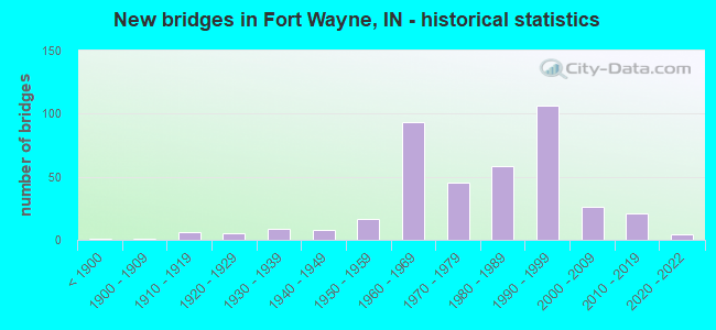
- New bridges - historical statistics
- 1Before 1900
- 11900-1909
- 61910-1919
- 51920-1929
- 91930-1939
- 81940-1949
- 171950-1959
- 931960-1969
- 451970-1979
- 581980-1989
- 1061990-1999
- 262000-2009
- 212010-2019
- 42020-2022
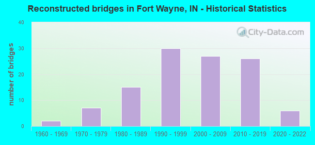
- Reconstructed bridges - Historical Statistics
- 21960-1969
- 71970-1979
- 151980-1989
- 301990-1999
- 272000-2009
- 262010-2019
- 62020-2022
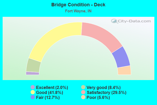
- Bridge Condition - Deck
- 2.0%Excellent
- 8.4%Very good
- 41.8%Good
- 29.5%Satisfactory
- 12.7%Fair
- 5.6%Poor
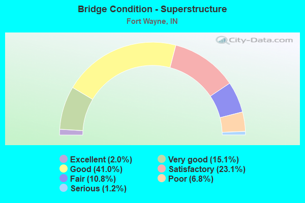
- Bridge Condition - Superstructure
- 2.0%Excellent
- 15.1%Very good
- 41.0%Good
- 23.1%Satisfactory
- 10.8%Fair
- 6.8%Poor
- 1.2%Serious
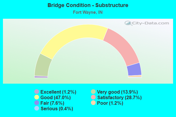
- Bridge Condition - Substructure
- 1.2%Excellent
- 13.9%Very good
- 47.0%Good
- 28.7%Satisfactory
- 7.6%Fair
- 1.2%Poor
- 0.4%Serious
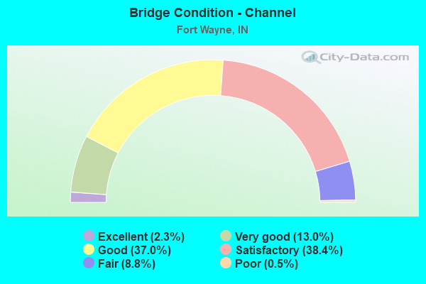
- Bridge Condition - Channel
- 2.3%Excellent
- 13.0%Very good
- 37.0%Good
- 38.4%Satisfactory
- 8.8%Fair
- 0.5%Poor
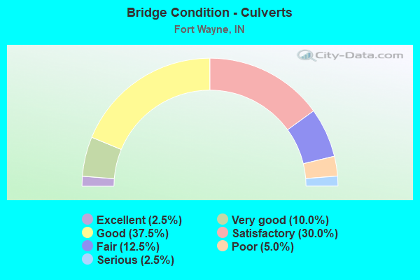
- Bridge Condition - Culverts
- 2.5%Excellent
- 10.0%Very good
- 37.5%Good
- 30.0%Satisfactory
- 12.5%Fair
- 5.0%Poor
- 2.5%Serious
Find on map >> Show street view
Structure Number: 200649, Location: 00.12 N BALMORAL DRIVE (Lat: 41.068981, Lng: -85.235100), Route carried "on" structure: City street , Year Built: 1980, Status: Open, Structure Length: 0.67m (2.20ft), Average Daily Traffic: 111 (year 2018), Truck Traffic: 1%, Average Future Daily Traffic: 184 (year 2038), Design Load: HS 20, Features Intersected: DURNELL DRAIN, Facility Carried by Structure: KINROSS LN
Minimum Vertical Clearance: 30+ m (98+ ft), Kilometerpoint: 0.000, Lanes on structure: 2, Owner: County Highway Agency, Approaching Roadway Width: 7.7m (25.3ft), Skew: 2 degrees, Material/Design: Concrete, Design/Construction: Culvert, Number Of Spans In Main Unit: 1, Length of Maximum Span: 6.7m (22.0ft), Curb or Sidewalk Widths: Left: 0.3m (1.0ft), Right: 0.3m (1.0ft), Curb-To-Curb Width: 7.7m (25.3ft), Out-to-Out Width: 11.6m (38.1ft)
Condition: Channel: Good, Culverts: Good, Operating Rating: 51.2 metric tons, Method Used To Determine Operating Rating: Load Factor (LF), Inventory Rating: 30.7 metric tons, Method Used To Determine Inventory Rating: Load Factor (LF), Structural Evaluation: Better than present minimum criteria, Deck Geometry: Somewhat better than minimum adequacy, Waterway Adequacy: Better than present minimum criteria, Approach Roadway Alignment: Equal to present desirable criteria, Designated Inspection Frequency: Every 24 months, Inspection Date: May 2020, Wearing Surface/Protective System: Wearing Surface: Bituminous
Find on map >> Show street view
Structure Number: 200651, Location: 00.90 N ARCOLA ROAD (Lat: 41.116969, Lng: -85.245750), Route carried "on" structure: County highway , Year Built: 1980, Status: Open, Structure Length: 0.85m (2.79ft), Average Daily Traffic: 867 (year 2018), Truck Traffic: 5%, Average Future Daily Traffic: 1,295 (year 2038), Features Intersected: SEEGAR DRAIN, Facility Carried by Structure: O'DAY RD
Minimum Vertical Clearance: 30+ m (98+ ft), Kilometerpoint: 0.000, Lanes on structure: 2, Owner: County Highway Agency, Approaching Roadway Width: 8.5m (27.9ft), Skew: 5 degrees, Material/Design: Steel, Design/Construction: Culvert, Number Of Spans In Main Unit: 1, Length of Maximum Span: 8.5m (27.9ft), Curb-To-Curb Width: 8.5m (27.9ft), Out-to-Out Width: 23.6m (77.4ft)
Condition: Channel: Satisfactory, Culverts: Satisfactory, Inventory Rating: 77.0 metric tons, Method Used To Determine Inventory Rating: Load and Resistance Factor (LRFR), Structural Evaluation: Equal to present minimum criteria, Deck Geometry: Somewhat better than minimum adequacy, Waterway Adequacy: Equal to present minimum criteria, Approach Roadway Alignment: Equal to present desirable criteria, Designated Inspection Frequency: Every 24 months, Inspection Date: May 2020
Find on map >> Show street view
Structure Number: 200653, Location: 00.06 E COVERDALE RD (Lat: 40.996800, Lng: -85.224831), Route carried "on" structure: City street , Year Built: 1995, Status: Open, Structure Length: 0.62m (2.03ft), Average Daily Traffic: 10,125 (year 2016), Truck Traffic: 8%, Average Future Daily Traffic: 14,025 (year 2036), Features Intersected: WELLBAUM DRAIN, Facility Carried by Structure: AIRPORT EXPY
Minimum Vertical Clearance: 30+ m (98+ ft), Kilometerpoint: 0.000, Lanes on structure: 5, Base Highway Network: Yes (, Subroute: 1), Owner: County Highway Agency, Approaching Roadway Width: 26.1m (85.6ft), Skew: 3 degrees, Material/Design: Steel, Design/Construction: Culvert, Number Of Spans In Main Unit: 1, Length of Maximum Span: 6.1m (20.0ft)
Condition: Channel: Good, Culverts: Good, Structural Evaluation: Better than present minimum criteria, Waterway Adequacy: Better than present minimum criteria, Approach Roadway Alignment: Equal to present desirable criteria, Designated Inspection Frequency: Every 24 months, Inspection Date: May 2020, Wearing Surface/Protective System: Wearing Surface: Monolithic Concrete
Find on map >> Show street view
Structure Number: 200654, Location: 00.56 E WHEELOCK RD (Lat: 41.136489, Lng: -85.013406), Route carried "on" structure: County highway 506, Year Built: 1960, Status: Open, Structure Length: 0.75m (2.46ft), Average Daily Traffic: 755 (year 2018), Truck Traffic: 3%, Average Future Daily Traffic: 1,128 (year 2038), Features Intersected: LANGLEY DRAIN, Facility Carried by Structure: ST JOE CENTER RD
Minimum Vertical Clearance: 30+ m (98+ ft), Kilometerpoint: 0.000, Lanes on structure: 2, Owner: County Highway Agency, Approaching Roadway Width: 6.7m (22.0ft), Material/Design: Steel, Design/Construction: Culvert, Number Of Spans In Main Unit: 2, Length of Maximum Span: 3.3m (10.8ft), Curb-To-Curb Width: 7.9m (25.9ft), Out-to-Out Width: 78.6m (257.9ft)
Condition: Channel: Good, Culverts: Good, Inventory Rating: 32.7 metric tons, Method Used To Determine Inventory Rating: Load Factor (LF), Structural Evaluation: Better than present minimum criteria, Deck Geometry: Somewhat better than minimum adequacy, Waterway Adequacy: Better than present minimum criteria, Approach Roadway Alignment: Equal to present desirable criteria, Designated Inspection Frequency: Every 24 months, Inspection Date: May 2020, Wearing Surface/Protective System: Wearing Surface: Bituminous
Find on map >> Show street view
Structure Number: 200659, Location: 00.10 S LINCOLN PKWY (Lat: 41.083869, Lng: -85.231061), Route carried "on" structure: City street , Year Built: 2004, Status: Open, Structure Length: 0.86m (2.82ft), Average Daily Traffic: 100 (year 2018), Truck Traffic: 25%, Average Future Daily Traffic: 150 (year 2038), Design Load: HS 20, Features Intersected: DURNELL DRAIN, Facility Carried by Structure: SUMPTER DR
Minimum Vertical Clearance: 30+ m (98+ ft), Kilometerpoint: 0.000, Lanes on structure: 2, Owner: County Highway Agency, Approaching Roadway Width: 7.5m (24.6ft), Skew: 3 degrees, Material/Design: Concrete, Design/Construction: Stringer/Multi-beam, Number Of Spans In Main Unit: 1, Length of Maximum Span: 7.6m (24.9ft), Curb-To-Curb Width: 7.5m (24.6ft), Out-to-Out Width: 21.5m (70.5ft)
Condition: Deck: Good, Superstructure: Good, Substructure: Good, Channel: Satisfactory, Operating Rating: 79.0 metric tons, Method Used To Determine Operating Rating: Load Factor (LF), Inventory Rating: 47.3 metric tons, Method Used To Determine Inventory Rating: Load Factor (LF), Structural Evaluation: Better than present minimum criteria, Deck Geometry: Equal to present minimum criteria, Waterway Adequacy: Better than present minimum criteria, Approach Roadway Alignment: Equal to present desirable criteria, Designated Inspection Frequency: Every 24 months, Inspection Date: May 2020, Deck Structure Type: Concrete Cast-file-Place, Wearing Surface/Protective System: Wearing Surface: Bituminous
Find on map >> Show street view
Structure Number: 20066, Location: 00.60 W DECATUR ROAD (Lat: 40.979211, Lng: -85.094769), Route carried "on" structure: County highway , Year Built: 2011, Status: Open, Structure Length: 6.97m (22.87ft), Average Daily Traffic: 156 (year 2018), Truck Traffic: 15%, Average Future Daily Traffic: 233 (year 2038), Design Load: HL 93, Features Intersected: ST MARYS RIVER, Facility Carried by Structure: BOSTICK RD
Minimum Vertical Clearance: 30+ m (98+ ft), Kilometerpoint: 0.000, Lanes on structure: 2, Owner: County Highway Agency, Approaching Roadway Width: 7.3m (24.0ft), Skew: 1 degrees, Material/Design: Prestressed concrete continuous, Design/Construction: Tee Beam, Number Of Spans In Main Unit: 3, Length of Maximum Span: 24.4m (80.1ft), Curb-To-Curb Width: 11.0m (36.1ft), Out-to-Out Width: 11.9m (39.0ft)
Condition: Deck: Satisfactory, Superstructure: Very good, Substructure: Good, Channel: Very good, Operating Rating: 74.8 metric tons, Method Used To Determine Operating Rating: Load and Resistance Factor (LRFR), Inventory Rating: 34.4 metric tons, Method Used To Determine Inventory Rating: Load and Resistance Factor (LRFR), Structural Evaluation: Better than present minimum criteria, Deck Geometry: Equal to present desirable criteria, Waterway Adequacy: Superior to present desirable criteria, Approach Roadway Alignment: Equal to present desirable criteria, Designated Inspection Frequency: Every 24 months, Inspection Date: May 2020, Deck Structure Type: Concrete Cast-file-Place, Wearing Surface/Protective System: Wearing Surface: Monolithic Concrete, Deck Protection: Epoxy Coated Reinforcing
Find on map >> Show street view
Structure Number: 200661, Location: 00.10 S UNION CHAPEL RD (Lat: 41.198881, Lng: -85.094939), Route carried "on" structure: County highway , Year Built: 2011, Status: Open, Structure Length: 0.91m (2.99ft), Average Daily Traffic: 941 (year 2018), Truck Traffic: 8%, Average Future Daily Traffic: 1,564 (year 2038), Design Load: HL 93, Features Intersected: BELOT DRAIN, Facility Carried by Structure: DIEBOLD RD
Minimum Vertical Clearance: 30+ m (98+ ft), Kilometerpoint: 0.000, Lanes on structure: 3, Owner: County Highway Agency, Approaching Roadway Width: 15.2m (49.9ft), Material/Design: Concrete, Design/Construction: Culvert, Number Of Spans In Main Unit: 1, Length of Maximum Span: 8.5m (27.9ft), Curb-To-Curb Width: 15.8m (51.8ft), Out-to-Out Width: 16.8m (55.1ft)
Condition: Channel: Good, Culverts: Very good, Operating Rating: 54.4 metric tons, Method Used To Determine Operating Rating: Field evaluation and documented engineering judgment, Inventory Rating: 32.7 metric tons, Method Used To Determine Inventory Rating: Field evaluation and documented engineering judgment, Structural Evaluation: Equal to present desirable criteria, Deck Geometry: Better than present minimum criteria, Waterway Adequacy: Better than present minimum criteria, Approach Roadway Alignment: Equal to present desirable criteria, Designated Inspection Frequency: Every 24 months, Inspection Date: June 2020
Find on map >> Show street view
Structure Number: 200662, Location: 00.10 N OF W SUPERIOR ST (Lat: 41.082031, Lng: -85.146519), Route carried "on" structure: City street , Year Built: 1981, Status: Open, Structure Length: 8.08m (26.51ft), Average Daily Traffic: 10,100 (year 2016), Truck Traffic: 5%, Average Future Daily Traffic: 14,000 (year 2036), Design Load: HS 20, Features Intersected: ST MARYS RIVER, Facility Carried by Structure: EWING ST NB
Minimum Vertical Clearance: 30+ m (98+ ft), Kilometerpoint: 0.000, Lanes on structure: 2, Owner: County Highway Agency, Approaching Roadway Width: 12.2m (40.0ft), Material/Design: Prestressed concrete continuous, Design/Construction: Stringer/Multi-beam, Number Of Spans In Main Unit: 5, Length of Maximum Span: 15.9m (52.2ft), Curb or Sidewalk Widths: Left: 0.0m, Right: 5.9m (19.4ft), Curb-To-Curb Width: 7.3m (24.0ft), Out-to-Out Width: 14.4m (47.2ft)
Condition: Deck: Fair, Superstructure: Good, Substructure: Satisfactory, Channel: Satisfactory, Operating Rating: 44.1 metric tons, Method Used To Determine Operating Rating: Field evaluation and documented engineering judgment, Inventory Rating: 32.7 metric tons, Method Used To Determine Inventory Rating: Field evaluation and documented engineering judgment, Structural Evaluation: Equal to present minimum criteria, Deck Geometry: High priority of replacement, Waterway Adequacy: Equal to present desirable criteria, Approach Roadway Alignment: Equal to present desirable criteria, Length Of Structure Improvement: 8.08m (26.51ft), Designated Inspection Frequency: Every 24 months, Underwater Inspection Frequency: Every 60 months, Inspection Date: May 2020, Underwater Inspection Date: October 2017, Bridge Improvement Cost: $1,000,000, Roadway Improvement Cost: $361,000, Total Project Cost: $1,361,000 ( Estimate for 2016), Deck Structure Type: Concrete Cast-file-Place, Wearing Surface/Protective System: Wearing Surface: Monolithic Concrete
Find on map >> Show street view
Structure Number: 200663, Location: 00.10 N OF W SUPERIOR ST (Lat: 41.082031, Lng: -85.146619), Route carried "on" structure: City street , Year Built: 1981, Status: Open, Structure Length: 8.08m (26.51ft), Average Daily Traffic: 10,100 (year 2016), Truck Traffic: 5%, Average Future Daily Traffic: 14,000 (year 2036), Design Load: HS 20, Features Intersected: ST MARYS RIVER, Facility Carried by Structure: EWING ST SB
Minimum Vertical Clearance: 30+ m (98+ ft), Kilometerpoint: 0.000, Lanes on structure: 2, Owner: County Highway Agency, Approaching Roadway Width: 12.2m (40.0ft), Material/Design: Prestressed concrete continuous, Design/Construction: Stringer/Multi-beam, Number Of Spans In Main Unit: 5, Length of Maximum Span: 15.9m (52.2ft), Curb or Sidewalk Widths: Left: 5.9m (19.4ft), Right: 0.0m, Curb-To-Curb Width: 7.3m (24.0ft), Out-to-Out Width: 14.4m (47.2ft)
Condition: Deck: Fair, Superstructure: Good, Substructure: Satisfactory, Channel: Satisfactory, Operating Rating: 44.1 metric tons, Method Used To Determine Operating Rating: Field evaluation and documented engineering judgment, Inventory Rating: 32.7 metric tons, Method Used To Determine Inventory Rating: Field evaluation and documented engineering judgment, Structural Evaluation: Equal to present minimum criteria, Deck Geometry: High priority of replacement, Waterway Adequacy: Equal to present desirable criteria, Approach Roadway Alignment: Equal to present desirable criteria, Length Of Structure Improvement: 8.08m (26.51ft), Designated Inspection Frequency: Every 24 months, Underwater Inspection Frequency: Every 60 months, Inspection Date: May 2020, Underwater Inspection Date: October 2017, Bridge Improvement Cost: $1,000,000, Roadway Improvement Cost: $361,000, Total Project Cost: $1,361,000 ( Estimate for 2016), Deck Structure Type: Concrete Cast-file-Place, Wearing Surface/Protective System: Wearing Surface: Monolithic Concrete
Find on map >> Show street view
Structure Number: 200666, Location: 00.51 N NOARROW (Lat: 41.197611, Lng: -85.100000), Route carried "on" structure: City street , Year Built: 2012, Status: Open, Structure Length: 1.37m (4.49ft), Average Daily Traffic: 526 (year 2018), Truck Traffic: 3%, Average Future Daily Traffic: 874 (year 2038), Design Load: HS 20, Features Intersected: ROY DELAGRANGE DRAIN, Facility Carried by Structure: PARKVIEW PLAZA
Minimum Vertical Clearance: 30+ m (98+ ft), Kilometerpoint: 0.000, Lanes on structure: 3, Owner: County Highway Agency, Approaching Roadway Width: 17.8m (58.4ft), Material/Design: Concrete, Design/Construction: Culvert, Number Of Spans In Main Unit: 1, Length of Maximum Span: 12.8m (42.0ft), Curb or Sidewalk Widths: Left: 2.6m (8.5ft), Right: 3.0m (9.8ft), Curb-To-Curb Width: 17.8m (58.4ft), Out-to-Out Width: 32.0m (105.0ft)
Condition: Channel: Good, Culverts: Good, Operating Rating: 54.4 metric tons, Method Used To Determine Operating Rating: Field evaluation and documented engineering judgment, Inventory Rating: 32.7 metric tons, Method Used To Determine Inventory Rating: Field evaluation and documented engineering judgment, Structural Evaluation: Better than present minimum criteria, Deck Geometry: Superior to present desirable criteria, Waterway Adequacy: Better than present minimum criteria, Approach Roadway Alignment: Equal to present desirable criteria, Designated Inspection Frequency: Every 24 months, Inspection Date: June 2020, Wearing Surface/Protective System: Wearing Surface: Bituminous
Find on map >> Show street view
Structure Number: 200669, Location: 00.60 S RIVER ROAD (Lat: 41.079639, Lng: -85.058850), Route carried "on" structure: City street , Year Built: 2012, Status: Open, Structure Length: 28.29m (92.81ft), Average Daily Traffic: 19,150 (year 2016), Truck Traffic: 5%, Average Future Daily Traffic: 29,575 (year 2036), Features Intersected: MAUMEE RIVER, Facility Carried by Structure: MAPLECREST RD
Minimum Vertical Clearance: 30+ m (98+ ft), Kilometerpoint: 0.000, Lanes on structure: 4, Owner: County Highway Agency, Approaching Roadway Width: 15.9m (52.2ft), Skew: 3 degrees, Navigation Control: Yes ( Vertical Clearance: 8.2m (26.9ft), Horizontal Clearance: 85.3m (279.9ft)), Material/Design: Prestressed concrete continuous, Design/Construction: Tee Beam, Number Of Spans In Main Unit: 7, Length of Maximum Span: 41.1m (134.8ft), Curb or Sidewalk Widths: Left: 0.0m, Right: 3.0m (9.8ft), Curb-To-Curb Width: 15.9m (52.2ft), Out-to-Out Width: 19.9m (65.3ft)
Condition: Deck: Good, Superstructure: Very good, Substructure: Good, Channel: Very good, Operating Rating: 44.1 metric tons, Method Used To Determine Operating Rating: Field evaluation and documented engineering judgment, Inventory Rating: 32.7 metric tons, Method Used To Determine Inventory Rating: Field evaluation and documented engineering judgment, Structural Evaluation: Better than present minimum criteria, Deck Geometry: Meets minimum limits, Waterway Adequacy: Better than present minimum criteria, Approach Roadway Alignment: Equal to present desirable criteria, Designated Inspection Frequency: Every 24 months, Underwater Inspection Frequency: Every 60 months, Inspection Date: May 2020, Underwater Inspection Date: August 2017, Deck Structure Type: Concrete Cast-file-Place, Wearing Surface/Protective System: Wearing Surface: Monolithic Concrete, Deck Protection: Epoxy Coated Reinforcing
Find on map >> Show street view
Structure Number: 200671, Location: 00.45 S TILLMAN ROAD (Lat: 41.012411, Lng: -85.126381), Route carried "on" structure: City street , Year Built: 1980, Status: Posted for load, Structure Length: 0.73m (2.40ft), Average Daily Traffic: 842 (year 2018), Truck Traffic: 4%, Average Future Daily Traffic: 1,399 (year 2038), Design Load: HS 20, Features Intersected: CURDES TILE ND #1, Facility Carried by Structure: HANNA ST
Minimum Vertical Clearance: 30+ m (98+ ft), Kilometerpoint: 0.000, Lanes on structure: 2, Owner: County Highway Agency, Approaching Roadway Width: 8.2m (26.9ft), Material/Design: Steel, Design/Construction: Culvert, Number Of Spans In Main Unit: 2, Length of Maximum Span: 3.4m (11.2ft), Curb or Sidewalk Widths: Left: 1.5m (4.9ft), Right: 0.0m, Curb-To-Curb Width: 8.2m (26.9ft), Out-to-Out Width: 20.1m (65.9ft)
Condition: Channel: Satisfactory, Culverts: Poor, Operating Rating: 93.1 metric tons, Method Used To Determine Operating Rating: Load Factor (LF), Inventory Rating: 32.7 metric tons, Method Used To Determine Inventory Rating: Load Factor (LF), Structural Evaluation: Meets minimum limits, Deck Geometry: Somewhat better than minimum adequacy, Waterway Adequacy: Better than present minimum criteria, Approach Roadway Alignment: Equal to present desirable criteria, Length Of Structure Improvement: 1.46m (4.79ft), Designated Inspection Frequency: Every 12 months, Inspection Date: May 2021, Bridge Improvement Cost: $100,000, Total Project Cost: $125,000 ( Estimate for 2021), Wearing Surface/Protective System: Wearing Surface: Bituminous
Find on map >> Show street view
Structure Number: 200674, Location: 00.40 W KROEMER RD (Lat: 41.088750, Lng: -85.218339), Route carried "on" structure: City street , Year Built: 2018, Status: Open, Structure Length: 1.74m (5.71ft), Average Daily Traffic: 9,990 (year 2016), Truck Traffic: 3%, Average Future Daily Traffic: 19,480 (year 2036), Design Load: HL 93, Features Intersected: FLAUGH DRAIN, Facility Carried by Structure: BASS RD
Minimum Vertical Clearance: 30+ m (98+ ft), Kilometerpoint: 0.000, Lanes on structure: 2, Owner: County Highway Agency, Approaching Roadway Width: 12.8m (42.0ft), Skew: 10 degrees, Material/Design: Prestressed concrete, Design/Construction: Box Beam or Girders - Single/Spread, Number Of Spans In Main Unit: 1, Length of Maximum Span: 16.4m (53.8ft), Curb or Sidewalk Widths: Left: 3.0m (9.8ft), Right: 0.0m, Curb-To-Curb Width: 13.0m (42.7ft), Out-to-Out Width: 16.8m (55.1ft)
Condition: Deck: Very good, Superstructure: Very good, Substructure: Very good, Channel: Very good, Inventory Rating: 50.0 metric tons, Method Used To Determine Inventory Rating: Load and Resistance Factor (LRFR), Structural Evaluation: Equal to present desirable criteria, Deck Geometry: Somewhat better than minimum adequacy, Waterway Adequacy: Superior to present desirable criteria, Approach Roadway Alignment: Equal to present desirable criteria, Designated Inspection Frequency: Every 24 months, Inspection Date: May 2020, Deck Structure Type: Concrete Cast-file-Place, Wearing Surface/Protective System: Wearing Surface: Monolithic Concrete, Deck Protection: Epoxy Coated Reinforcing
Find on map >> Show street view
Structure Number: 200675, Location: 00.30 S SR 14 (Lat: 41.072139, Lng: -85.309150), Route carried "on" structure: County highway , Year Built: 2018, Status: Open, Structure Length: 2.38m (7.81ft), Average Daily Traffic: 2,438 (year 2018), Truck Traffic: 5%, Average Future Daily Traffic: 3,643 (year 2038), Design Load: HS 20, Features Intersected: BEAL-TAYLOR DRAIN, Facility Carried by Structure: WEST HAMILTON RD
Minimum Vertical Clearance: 30+ m (98+ ft), Kilometerpoint: 0.000, Lanes on structure: 2, Owner: County Highway Agency, Approaching Roadway Width: 13.4m (44.0ft), Material/Design: Concrete continuous, Design/Construction: Slab, Number Of Spans In Main Unit: 3, Length of Maximum Span: 9.3m (30.5ft), Curb or Sidewalk Widths: Left: 3.0m (9.8ft), Right: 2.0m (6.6ft), Curb-To-Curb Width: 13.4m (44.0ft), Out-to-Out Width: 19.2m (63.0ft)
Condition: Deck: Very good, Superstructure: Very good, Substructure: Very good, Channel: Excellent, Operating Rating: 76.5 metric tons, Method Used To Determine Operating Rating: Load Factor (LF), Inventory Rating: 45.8 metric tons, Method Used To Determine Inventory Rating: Load Factor (LF), Structural Evaluation: Equal to present desirable criteria, Deck Geometry: Better than present minimum criteria, Waterway Adequacy: Equal to present desirable criteria, Approach Roadway Alignment: Equal to present desirable criteria, Designated Inspection Frequency: Every 24 months, Inspection Date: June 2020, Deck Structure Type: Concrete Cast-file-Place, Wearing Surface/Protective System: Wearing Surface: Monolithic Concrete, Deck Protection: Epoxy Coated Reinforcing
Find on map >> Show street view
Structure Number: 200676, Location: 00.40 W OF SR 3 (Lat: 41.132311, Lng: -85.169089), Route carried "on" structure: City street , Year Built: 2018, Status: Open, Structure Length: 1.92m (6.30ft), Average Daily Traffic: 14,100 (year 2018), Truck Traffic: 5%, Average Future Daily Traffic: 18,000 (year 2037), Design Load: HL 93, Features Intersected: SPY RUN CREEK, Facility Carried by Structure: WASHINGTON CENTER
Minimum Vertical Clearance: 30+ m (98+ ft), Kilometerpoint: 0.000, Lanes on structure: 4, Owner: City or Municipal Highway Agency, Approaching Roadway Width: 14.3m (46.9ft), Skew: - degrees, Material/Design: Concrete continuous, Design/Construction: Slab, Number Of Spans In Main Unit: 3, Length of Maximum Span: 7.9m (25.9ft), Curb or Sidewalk Widths: Left: 2.5m (8.2ft), Right: 0.0m, Curb-To-Curb Width: 14.3m (46.9ft), Out-to-Out Width: 17.5m (57.4ft)
Condition: Deck: Good, Superstructure: Good, Substructure: Very good, Channel: Excellent, Operating Rating: 66.7 metric tons, Method Used To Determine Operating Rating: Load and Resistance Factor (LRFR), Inventory Rating: 51.4 metric tons, Method Used To Determine Inventory Rating: Load and Resistance Factor (LRFR), Structural Evaluation: Better than present minimum criteria, Deck Geometry: High priority of replacement, Waterway Adequacy: Equal to present desirable criteria, Approach Roadway Alignment: Equal to present desirable criteria, Designated Inspection Frequency: Every 24 months, Inspection Date: May 2020, Deck Structure Type: Concrete Cast-file-Place, Wearing Surface/Protective System: Wearing Surface: Monolithic Concrete, Deck Protection: Epoxy Coated Reinforcing
Find on map >> Show street view
Structure Number: 200678, Location: 00.10 S OF MCDONALD ST (Lat: 41.071489, Lng: -85.099450), Route carried "on" structure: City street , Year Built: 2019, Status: Open, Structure Length: 2.12m (6.96ft), Average Daily Traffic: 2,630 (year 2018), Truck Traffic: 3%, Average Future Daily Traffic: 4,372 (year 2038), Design Load: HL 93, Features Intersected: NORFOLK SOUTHERN R/R, Facility Carried by Structure: EDSALL AVE
Minimum Vertical Clearance: 30+ m (98+ ft), Kilometerpoint: 0.000, Lanes on structure: 2, Owner: County Highway Agency, Approaching Roadway Width: 6.7m (22.0ft), Material/Design: Steel, Design/Construction: Stringer/Multi-beam, Number Of Spans In Main Unit: 1, Length of Maximum Span: 20.9m (68.6ft), Curb or Sidewalk Widths: Left: 1.8m (5.9ft), Right: 1.8m (5.9ft), Curb-To-Curb Width: 7.4m (24.3ft), Out-to-Out Width: 12.5m (41.0ft)
Condition: Deck: Excellent, Superstructure: Excellent, Substructure: Excellent, Inventory Rating: 81.8 metric tons, Method Used To Determine Inventory Rating: Load and Resistance Factor (LRFR), Structural Evaluation: Superior to present desirable criteria, Deck Geometry: High priority of replacement, Underclear: Superior to present desirable criteria, Approach Roadway Alignment: Equal to present minimum criteria, Designated Inspection Frequency: Every 24 months, Inspection Date: May 2020, Deck Structure Type: Concrete Cast-file-Place, Wearing Surface/Protective System: Wearing Surface: Monolithic Concrete, Deck Protection: Epoxy Coated Reinforcing
Find on map >> Show street view
Structure Number: 20068, Location: 00.40 S OF COOK ROAD (Lat: 41.142211, Lng: -85.245369), Route carried "on" structure: County highway , Year Built: 2020, Status: Open, Structure Length: 1.39m (4.56ft), Average Daily Traffic: 1,028 (year 2019), Truck Traffic: 5%, Average Future Daily Traffic: 1,454 (year 2039), Design Load: HL 93, Features Intersected: SEEGAR DITCH, Facility Carried by Structure: O'DAY ROAD
Minimum Vertical Clearance: 30+ m (98+ ft), Kilometerpoint: 0.000, Lanes on structure: 2, Owner: County Highway Agency, Approaching Roadway Width: 11.0m (36.1ft), Skew: 1 degrees, Material/Design: Concrete, Design/Construction: Slab, Number Of Spans In Main Unit: 1, Length of Maximum Span: 12.7m (41.7ft), Curb-To-Curb Width: 11.0m (36.1ft), Out-to-Out Width: 11.9m (39.0ft)
Condition: Deck: Excellent, Superstructure: Excellent, Substructure: Excellent, Channel: Excellent, Operating Rating: 58.5 metric tons, Method Used To Determine Operating Rating: Load and Resistance Factor (LRFR), Inventory Rating: 45.2 metric tons, Method Used To Determine Inventory Rating: Load and Resistance Factor (LRFR), Structural Evaluation: Superior to present desirable criteria, Deck Geometry: Equal to present minimum criteria, Waterway Adequacy: Superior to present desirable criteria, Approach Roadway Alignment: Equal to present desirable criteria, Designated Inspection Frequency: Every 24 months, Inspection Date: May 2020, Deck Structure Type: Concrete Cast-file-Place, Wearing Surface/Protective System: Wearing Surface: Monolithic Concrete, Deck Protection: Epoxy Coated Reinforcing
Find on map >> Show street view
Structure Number: 200681, Location: 00.10 E OF WESTBROOK DR (Lat: 41.096300, Lng: -85.142411), Route carried "on" structure: City street , Year Built: 2020, Status: Open, Structure Length: 3.54m (11.61ft), Average Daily Traffic: 20,650 (year 2009), Truck Traffic: 2%, Average Future Daily Traffic: 26,200 (year 2030), Design Load: HL 93, Features Intersected: SPY RUN CREEK, Facility Carried by Structure: STATE BOULEVARD
Minimum Vertical Clearance: 30+ m (98+ ft), Kilometerpoint: 0.000, Lanes on structure: 5, Owner: County Highway Agency, Approaching Roadway Width: 16.2m (53.1ft), Skew: 3 degrees, Material/Design: Prestressed concrete continuous, Design/Construction: Box Beam or Girders - Single/Spread, Number Of Spans In Main Unit: 3, Length of Maximum Span: 17.7m (58.1ft), Curb or Sidewalk Widths: Left: 4.5m (14.8ft), Right: 3.8m (12.5ft), Curb-To-Curb Width: 17.1m (56.1ft), Out-to-Out Width: 26.2m (86.0ft)
Condition: Deck: Very good, Superstructure: Very good, Substructure: Very good, Channel: Very good, Operating Rating: 75.0 metric tons, Method Used To Determine Operating Rating: Load and Resistance Factor (LRFR), Inventory Rating: 55.6 metric tons, Method Used To Determine Inventory Rating: Load and Resistance Factor (LRFR), Structural Evaluation: Equal to present desirable criteria, Deck Geometry: High priority of replacement, Waterway Adequacy: Superior to present desirable criteria, Approach Roadway Alignment: Equal to present desirable criteria, Designated Inspection Frequency: Every 24 months, Inspection Date: Febuary 2021, Deck Structure Type: Concrete Cast-file-Place, Wearing Surface/Protective System: Wearing Surface: Monolithic Concrete, Deck Protection: Epoxy Coated Reinforcing
Find on map >> Show street view
Structure Number: 200682, Location: 00.10 W MAYSVILLE ROAD (Lat: 41.106569, Lng: -85.042339), Route carried "on" structure: City street , Year Built: 2020, Status: Open, Structure Length: 2.29m (7.51ft), Average Daily Traffic: 17,750 (year 2016), Truck Traffic: 7%, Average Future Daily Traffic: 30,000 (year 2036), Design Load: HS 20, Features Intersected: BULLERMAN DRAIN, Facility Carried by Structure: STATE BOULEVARD
Minimum Vertical Clearance: 30+ m (98+ ft), Kilometerpoint: 0.000, Lanes on structure: 2, Owner: County Highway Agency, Approaching Roadway Width: 11.0m (36.1ft), Skew: 3 degrees, Material/Design: Concrete continuous, Design/Construction: Slab, Number Of Spans In Main Unit: 3, Length of Maximum Span: 8.5m (27.9ft), Curb or Sidewalk Widths: Left: 1.8m (5.9ft), Right: 1.8m (5.9ft), Curb-To-Curb Width: 11.0m (36.1ft), Out-to-Out Width: 15.2m (49.9ft)
Condition: Deck: Good, Superstructure: Good, Substructure: Very good, Channel: Very good, Operating Rating: 60.2 metric tons, Method Used To Determine Operating Rating: Load and Resistance Factor (LRFR), Inventory Rating: 44.7 metric tons, Method Used To Determine Inventory Rating: Load and Resistance Factor (LRFR), Structural Evaluation: Better than present minimum criteria, Deck Geometry: Meets minimum limits, Waterway Adequacy: Better than present minimum criteria, Approach Roadway Alignment: Equal to present desirable criteria, Designated Inspection Frequency: Every 24 months, Inspection Date: Febuary 2021, Deck Structure Type: Concrete Cast-file-Place, Wearing Surface/Protective System: Wearing Surface: Monolithic Concrete, Deck Protection: Epoxy Coated Reinforcing
Find on map >> Show street view
Structure Number: 9200037, Location: 00.15 E CR 750 E (Lat: 41.034581, Lng: -85.352875), Route carried "on" structure: Alternate County highway 6, Year Built: 1930, Status: Open, Structure Length: 0.79m (2.59ft), Average Daily Traffic: 150 (year 2014), Truck Traffic: 5%, Average Future Daily Traffic: 250 (year 2038), Features Intersected: HINEN DRAIN, Facility Carried by Structure: CR 900S
Minimum Vertical Clearance: 30+ m (98+ ft), Kilometerpoint: 0.000, Lanes on structure: 2, Owner: County Highway Agency, Approaching Roadway Width: 5.5m (18.0ft), Material/Design: Concrete, Design/Construction: Slab, Number Of Spans In Main Unit: 1, Length of Maximum Span: 7.2m (23.6ft), Curb-To-Curb Width: 7.6m (24.9ft), Out-to-Out Width: 8.5m (27.9ft)
Condition: Deck: Satisfactory, Superstructure: Satisfactory, Substructure: Satisfactory, Channel: Good, Operating Rating: 32.7 metric tons, Method Used To Determine Operating Rating: Field evaluation and documented engineering judgment, Inventory Rating: 26.1 metric tons, Method Used To Determine Inventory Rating: Field evaluation and documented engineering judgment, Structural Evaluation: Equal to present minimum criteria, Deck Geometry: Somewhat better than minimum adequacy, Waterway Adequacy: Better than present minimum criteria, Approach Roadway Alignment: Equal to present minimum criteria, Designated Inspection Frequency: Every 24 months, Inspection Date: March 2020, Deck Structure Type: Concrete Cast-file-Place, Wearing Surface/Protective System: Wearing Surface: Bituminous
Find on map >> Show street view
Structure Number: 9200038, Location: 00.30 W CR 800 E (Lat: 41.034431, Lng: -85.342011), Route carried "on" structure: Alternate County highway 6, Year Built: 1954, Status: Open, Structure Length: 0.76m (2.49ft), Average Daily Traffic: 150 (year 2014), Truck Traffic: 4%, Average Future Daily Traffic: 250 (year 2038), Features Intersected: HINEN DRAIN, Facility Carried by Structure: CR 900S
Minimum Vertical Clearance: 30+ m (98+ ft), Kilometerpoint: 0.000, Lanes on structure: 2, Owner: County Highway Agency, Approaching Roadway Width: 5.5m (18.0ft), Material/Design: Concrete, Design/Construction: Slab, Number Of Spans In Main Unit: 1, Length of Maximum Span: 6.6m (21.7ft), Curb-To-Curb Width: 7.5m (24.6ft), Out-to-Out Width: 7.9m (25.9ft)
Condition: Deck: Satisfactory, Superstructure: Satisfactory, Substructure: Satisfactory, Channel: Satisfactory, Operating Rating: 32.7 metric tons, Method Used To Determine Operating Rating: Field evaluation and documented engineering judgment, Inventory Rating: 26.1 metric tons, Method Used To Determine Inventory Rating: Field evaluation and documented engineering judgment, Structural Evaluation: Equal to present minimum criteria, Deck Geometry: Somewhat better than minimum adequacy, Waterway Adequacy: Better than present minimum criteria, Approach Roadway Alignment: Equal to present minimum criteria, Designated Inspection Frequency: Every 24 months, Inspection Date: March 2020, Deck Structure Type: Concrete Cast-file-Place, Wearing Surface/Protective System: Wearing Surface: Bituminous
Find on map >> Show street view
Structure Number: 920006, Location: 00.10 N CR 900 S (Lat: 41.035950, Lng: -85.355186), Route carried "on" structure: Alternate County highway 77, Year Built: 1957, Status: Open, Structure Length: 0.90m (2.95ft), Average Daily Traffic: 150 (year 2014), Truck Traffic: 4%, Average Future Daily Traffic: 225 (year 2038), Features Intersected: HINEN DRAIN, Facility Carried by Structure: CR 700E
Minimum Vertical Clearance: 30+ m (98+ ft), Kilometerpoint: 0.000, Lanes on structure: 2, Owner: County Highway Agency, Approaching Roadway Width: 5.8m (19.0ft), Skew: 2 degrees, Material/Design: Concrete, Design/Construction: Channel Beam, Number Of Spans In Main Unit: 1, Length of Maximum Span: 8.2m (26.9ft), Curb or Sidewalk Widths: Left: 0.3m (1.0ft), Right: 0.3m (1.0ft), Curb-To-Curb Width: 6.3m (20.7ft), Out-to-Out Width: 6.9m (22.6ft)
Condition: Deck: Fair, Superstructure: Fair, Substructure: Satisfactory, Channel: Fair, Operating Rating: 32.7 metric tons, Method Used To Determine Operating Rating: Field evaluation and documented engineering judgment, Inventory Rating: 26.1 metric tons, Method Used To Determine Inventory Rating: Field evaluation and documented engineering judgment, Structural Evaluation: Somewhat better than minimum adequacy, Deck Geometry: Meets minimum limits, Waterway Adequacy: Equal to present minimum criteria, Approach Roadway Alignment: Equal to present minimum criteria, Designated Inspection Frequency: Every 24 months, Inspection Date: March 2020, Deck Structure Type: Concrete Precast Panels, Wearing Surface/Protective System: Wearing Surface: Bituminous
Find on map >> Show street view
Structure Number: 9200062, Location: 00.20 N OF CR 900 S (Lat: 41.036039, Lng: -85.336122), Route carried "on" structure: Alternate County highway , Year Built: 2016, Status: Open, Structure Length: 1.37m (4.49ft), Average Daily Traffic: 400 (year 2015), Truck Traffic: 4%, Average Future Daily Traffic: 1,500 (year 2038), Design Load: HS 20, Features Intersected: BIG INDIAN CREEK, Facility Carried by Structure: CR 800E
Minimum Vertical Clearance: 30+ m (98+ ft), Kilometerpoint: 0.000, Lanes on structure: 2, Owner: County Highway Agency, Approaching Roadway Width: 6.1m (20.0ft), Skew: 1 degrees, Material/Design: Prestressed concrete, Design/Construction: Box Beam or Girders - Multiple, Number Of Spans In Main Unit: 1, Length of Maximum Span: 12.5m (41.0ft), Curb-To-Curb Width: 9.8m (32.2ft), Out-to-Out Width: 10.4m (34.1ft)
Condition: Deck: Very good, Superstructure: Good, Substructure: Very good, Channel: Satisfactory, Operating Rating: 65.1 metric tons, Method Used To Determine Operating Rating: Load Factor (LF), Inventory Rating: 39.0 metric tons, Method Used To Determine Inventory Rating: Load Factor (LF), Structural Evaluation: Better than present minimum criteria, Deck Geometry: Better than present minimum criteria, Waterway Adequacy: Equal to present minimum criteria, Approach Roadway Alignment: Equal to present desirable criteria, Designated Inspection Frequency: Every 24 months, Inspection Date: March 2020, Deck Structure Type: Concrete Cast-file-Place, Wearing Surface/Protective System: Wearing Surface: Monolithic Concrete, Deck Protection: Epoxy Coated Reinforcing
Find on map >> Show street view
Structure Number: 425, Location: 08.54 N US 224 (Lat: 40.954511, Lng: -85.167672), Route carried "under" structure: Interstate 469, Year Built: 1990, Structure Length: 0. m, Average Daily Traffic: 11,351 (year 2021), Truck Traffic: 41%, Features Intersected: I-469 WB, Facility Carried by Structure: SR 1
Minimum Vertical Clearance: 5.08m (16.67ft), Kilometerpoint: 10.429, Lanes on structure: 5, Lanes under structure: 2, Material/Design: Steel continuous, Design/Construction: Stringer/Multi-beam, Length of Maximum Span: 28.7m (94.2ft)
Find on map >> Show street view
Structure Number: 425, Location: 08.54 N US 224 (Lat: 40.954511, Lng: -85.167672), Route carried "under" structure: Interstate 469, Year Built: 1990, Structure Length: 0. m, Average Daily Traffic: 11,351 (year 2021), Truck Traffic: 41%, Features Intersected: I-469 EB, Facility Carried by Structure: SR 1
Minimum Vertical Clearance: 5.08m (16.67ft), Kilometerpoint: 10.429, Lanes on structure: 5, Lanes under structure: 2, Material/Design: Steel continuous, Design/Construction: Stringer/Multi-beam, Length of Maximum Span: 28.7m (94.2ft)
Find on map >> Show street view
Structure Number: 435, Location: 19.45 S SR 8 (Lat: 41.178889, Lng: -85.103469), Route carried "under" structure: Interstate 69, Year Built: 1996, Structure Length: 0. m, Average Daily Traffic: 30,413 (year 2019), Truck Traffic: 12%, Features Intersected: I-69 NB, Facility Carried by Structure: SR 1/DUPONT RD
Minimum Vertical Clearance: 5.11m (16.77ft), Kilometerpoint: 185.799, Lanes on structure: 5, Lanes under structure: 3, Material/Design: Prestressed concrete continuous, Design/Construction: Tee Beam, Length of Maximum Span: 35.1m (115.2ft)
Find on map >> Show street view
Structure Number: 435, Location: 19.45 S SR 8 (Lat: 41.178889, Lng: -85.103469), Route carried "under" structure: Interstate 69, Year Built: 1996, Structure Length: 0. m, Average Daily Traffic: 34,147 (year 2019), Truck Traffic: 10%, Features Intersected: I-69 SB, Facility Carried by Structure: SR 1/DUPONT RD
Minimum Vertical Clearance: 5.11m (16.77ft), Kilometerpoint: 185.799, Lanes on structure: 5, Lanes under structure: 3, Material/Design: Prestressed concrete continuous, Design/Construction: Tee Beam, Length of Maximum Span: 35.1m (115.2ft)
Find on map >> Show street view
Structure Number: 128, Location: 00.00 N I-69 (Lat: 41.129411, Lng: -85.158111), Route carried "under" structure: Interstate 69, Year Built: 1960, Structure Length: 0. m, Average Daily Traffic: 35,239 (year 2017), Truck Traffic: 8%, Features Intersected: I-69 SB, Facility Carried by Structure: SR 3 NB
Minimum Vertical Clearance: 5.64m (18.50ft), Kilometerpoint: 178.074, Lanes on structure: 4, Lanes under structure: 3, Material/Design: Prestressed concrete continuous, Design/Construction: Stringer/Multi-beam, Length of Maximum Span: 24.0m (78.7ft)
Find on map >> Show street view
Structure Number: 128, Location: 00.00 N I-69 (Lat: 41.129411, Lng: -85.158111), Route carried "under" structure: Interstate 69, Year Built: 1960, Structure Length: 0. m, Average Daily Traffic: 35,825 (year 2017), Truck Traffic: 12%, Features Intersected: I-69 NB, Facility Carried by Structure: SR 3 NB
Minimum Vertical Clearance: 5.64m (18.50ft), Kilometerpoint: 178.074, Lanes on structure: 4, Lanes under structure: 3, Material/Design: Prestressed concrete continuous, Design/Construction: Stringer/Multi-beam, Length of Maximum Span: 24.0m (78.7ft)
Find on map >> Show street view
Structure Number: 129, Location: 00.00 N I-69 (Lat: 41.129339, Lng: -85.158317), Route carried "under" structure: Interstate 69, Year Built: 1960, Structure Length: 0. m, Average Daily Traffic: 35,825 (year 2017), Truck Traffic: 12%, Features Intersected: I-69 NB, Facility Carried by Structure: SR 3 SB
Minimum Vertical Clearance: 5.74m (18.83ft), Kilometerpoint: 178.058, Lanes on structure: 4, Lanes under structure: 6, Material/Design: Prestressed concrete continuous, Design/Construction: Stringer/Multi-beam, Length of Maximum Span: 24.0m (78.7ft)
Find on map >> Show street view
Structure Number: 129, Location: 00.00 N I-69 (Lat: 41.129339, Lng: -85.158317), Route carried "under" structure: Interstate 69, Year Built: 1960, Structure Length: 0. m, Average Daily Traffic: 35,239 (year 2017), Truck Traffic: 25%, Features Intersected: I-69 SB, Facility Carried by Structure: SR 3 SB
Minimum Vertical Clearance: 5.74m (18.83ft), Kilometerpoint: 178.058, Lanes on structure: 4, Lanes under structure: 6, Material/Design: Prestressed concrete continuous, Design/Construction: Stringer/Multi-beam, Length of Maximum Span: 24.0m (78.7ft)
Find on map >> Show street view
Structure Number: 386, Location: 12.72 E SR 9 (Lat: 41.074519, Lng: -85.228339), Route carried "under" structure: Interstate 69, Year Built: 1960, Structure Length: 0. m, Average Daily Traffic: 26,261 (year 2019), Truck Traffic: 11%, Features Intersected: I-69 NB, Facility Carried by Structure: SR 14
Minimum Vertical Clearance: 5.03m (16.50ft), Kilometerpoint: 168.997, Lanes on structure: 6, Lanes under structure: 8, Material/Design: Steel continuous, Design/Construction: Stringer/Multi-beam, Length of Maximum Span: 22.6m (74.1ft)
Find on map >> Show street view
Structure Number: 386, Location: 12.72 E SR 9 (Lat: 41.074519, Lng: -85.228339), Route carried "under" structure: Interstate 69, Year Built: 1960, Structure Length: 0. m, Average Daily Traffic: 26,261 (year 2019), Truck Traffic: 11%, Features Intersected: I-69 SB, Facility Carried by Structure: SR 14
Minimum Vertical Clearance: 5.03m (16.50ft), Kilometerpoint: 168.997, Lanes on structure: 6, Lanes under structure: 8, Material/Design: Steel continuous, Design/Construction: Stringer/Multi-beam, Length of Maximum Span: 22.6m (74.1ft)
Find on map >> Show street view
Structure Number: 747, Location: 07.14 N I-469 (Lat: 41.071500, Lng: -85.133522), Route carried "under" structure: US 27, Year Built: 1914, Structure Length: 0. m, Average Daily Traffic: 8,707 (year 2020), Truck Traffic: 2%, Features Intersected: US 27 NB (R LANE), Facility Carried by Structure: NS RR & CFE RR
Minimum Vertical Clearance: 4.42m (14.50ft), Kilometerpoint: 20.809, Lanes under structure: 2, Material/Design: Concrete, Design/Construction: Slab, Length of Maximum Span: 5.9m (19.4ft)
Find on map >> Show street view
Structure Number: 747, Location: 07.14 N I-469 (Lat: 41.071500, Lng: -85.133522), Route carried "under" structure: US 27, Year Built: 1914, Structure Length: 0. m, Average Daily Traffic: 8,707 (year 2020), Truck Traffic: 4%, Features Intersected: US 27 NB (L LANE), Facility Carried by Structure: NS RR & CFE RR
Minimum Vertical Clearance: 4.42m (14.50ft), Kilometerpoint: 20.809, Lanes under structure: 2, Material/Design: Concrete, Design/Construction: Slab, Length of Maximum Span: 5.9m (19.4ft)
Find on map >> Show street view
Structure Number: 748, Location: 02.70 S SR 930 (Lat: 41.082431, Lng: -85.135453), Route carried "under" structure: US 27, Year Built: 1955, Structure Length: 0. m, Average Daily Traffic: 23,571 (year 2016), Truck Traffic: 20%, Features Intersected: US 27 NB, Facility Carried by Structure: NS RR (CHICAGO)
Minimum Vertical Clearance: 4.65m (15.26ft), Kilometerpoint: 21.968, Lanes under structure: 4, Material/Design: Steel, Design/Construction: Girder and Floorbeam System, Length of Maximum Span: 21.9m (71.9ft)
Find on map >> Show street view
Structure Number: 752, Location: 02.68 S SR 930 (Lat: 41.082161, Lng: -85.138817), Route carried "under" structure: US 27, Year Built: 1955, Structure Length: 0. m, Average Daily Traffic: 28,559 (year 2021), Truck Traffic: 10%, Features Intersected: US 27 SB, Facility Carried by Structure: NS RR (CHICAGO)
Minimum Vertical Clearance: 4.32m (14.17ft), Kilometerpoint: 1.963, Lanes under structure: 4, Material/Design: Steel continuous, Design/Construction: Stringer/Multi-beam, Length of Maximum Span: 20.4m (66.9ft)
Find on map >> Show street view
Structure Number: 753, Location: 03.43 S SR 930 (Lat: 41.071500, Lng: -85.136758), Route carried "under" structure: US 27, Year Built: 1936, Structure Length: 0. m, Average Daily Traffic: 17,822 (year 2018), Truck Traffic: 20%, Features Intersected: US 27 SB, Facility Carried by Structure: NS RR & CFE RR
Minimum Vertical Clearance: 4.24m (13.91ft), Kilometerpoint: 3.170, Lanes under structure: 3, Material/Design: Steel, Design/Construction: Stringer/Multi-beam, Length of Maximum Span: 14.1m (46.3ft)
Find on map >> Show street view
Structure Number: 8731, Location: 00.23 E US-33 (Lat: 41.125739, Lng: -85.192603), Route carried "under" structure: US 30, Year Built: 2018, Structure Length: 0. m, Average Daily Traffic: 20,033 (year 2019), Truck Traffic: 19%, Features Intersected: US-30 WB & US-33 NB, Facility Carried by Structure: HILLEGAS ROAD
Minimum Vertical Clearance: 5.08m (16.67ft), Kilometerpoint: 12.295, Lanes on structure: 2, Lanes under structure: 6, Material/Design: Prestressed concrete continuous, Design/Construction: Tee Beam, Length of Maximum Span: 21.9m (71.9ft)
Find on map >> Show street view
Structure Number: 8731, Location: 00.23 E US-33 (Lat: 41.125739, Lng: -85.192603), Route carried "under" structure: US 30, Year Built: 2018, Structure Length: 0. m, Average Daily Traffic: 20,033 (year 2019), Truck Traffic: 19%, Features Intersected: US-30 EB & US-33 SB, Facility Carried by Structure: HILLEGAS ROAD
Minimum Vertical Clearance: 5.08m (16.67ft), Kilometerpoint: 12.295, Lanes on structure: 2, Lanes under structure: 6, Material/Design: Prestressed concrete continuous, Design/Construction: Tee Beam, Length of Maximum Span: 21.9m (71.9ft)
Find on map >> Show street view
Structure Number: 874, Location: 00.63 E US-33 (Lat: 41.122211, Lng: -85.186767), Route carried "under" structure: Interstate 69, Year Built: 1961, Structure Length: 0. m, Average Daily Traffic: 33,680 (year 2020), Truck Traffic: 15%, Features Intersected: I-69, Facility Carried by Structure: US 30/33, SR 930
Minimum Vertical Clearance: 4.95m (16.24ft), Kilometerpoint: 175.386, Lanes on structure: 6, Lanes under structure: 6, Material/Design: Steel continuous, Design/Construction: Stringer/Multi-beam, Length of Maximum Span: 22.8m (74.8ft)
Find on map >> Show street view
Structure Number: 881, Location: 05.22 W I-469 (Lat: 41.073300, Lng: -85.087547), Route carried "under" structure: State highway 930, Year Built: 1953, Structure Length: 0. m, Average Daily Traffic: 16,923 (year 2004), Truck Traffic: 5%, Features Intersected: SR 930 EB, Washington St
Minimum Vertical Clearance: 4.57m (14.99ft), Kilometerpoint: 12.424, Lanes on structure: 4, Lanes under structure: 6, Material/Design: Concrete continuous, Design/Construction: Slab, Length of Maximum Span: 15.9m (52.2ft)
Find on map >> Show street view
Structure Number: 881, Location: 05.22 W I-469 (Lat: 41.073300, Lng: -85.087547), Route carried "under" structure: State highway 930, Year Built: 1953, Structure Length: 0. m, Average Daily Traffic: 16,923 (year 2004), Truck Traffic: 5%, Features Intersected: SR 930 EB, Washington St
Minimum Vertical Clearance: 4.72m (15.49ft), Kilometerpoint: 12.424, Lanes on structure: 4, Lanes under structure: 6, Material/Design: Concrete continuous, Design/Construction: Slab, Length of Maximum Span: 15.9m (52.2ft)
Find on map >> Show street view
Structure Number: 10895, Location: 00.63 N US-30 (Lat: 41.126600, Lng: -85.196778), Route carried "under" structure: US 30, Year Built: 1961, Structure Length: 0. m, Average Daily Traffic: 40,056 (year 2019), Truck Traffic: 25%, Features Intersected: US 30 EB, Facility Carried by Structure: US 33
Minimum Vertical Clearance: 4.65m (15.26ft), Kilometerpoint: 11.925, Lanes on structure: 2, Lanes under structure: 5, Material/Design: Steel continuous, Design/Construction: Stringer/Multi-beam, Length of Maximum Span: 15.8m (51.8ft)
Find on map >> Show street view
Structure Number: 10895, Location: 00.63 N US-30 (Lat: 41.126600, Lng: -85.196778), Route carried "under" structure: US 30, Year Built: 1961, Structure Length: 0. m, Average Daily Traffic: 40,056 (year 2019), Truck Traffic: 25%, Features Intersected: US 30 WB, Facility Carried by Structure: US 33
Minimum Vertical Clearance: 4.65m (15.26ft), Kilometerpoint: 11.925, Lanes on structure: 2, Lanes under structure: 5, Material/Design: Steel continuous, Design/Construction: Stringer/Multi-beam, Length of Maximum Span: 15.8m (51.8ft)
Find on map >> Show street view
Structure Number: 32826, Location: 01.79 E I-69 (Lat: 40.954239, Lng: -85.258042), Route carried "under" structure: Interstate 469, Year Built: 1987, Structure Length: 0. m, Average Daily Traffic: 10,362 (year 2020), Truck Traffic: 35%, Features Intersected: I-469 EB, Facility Carried by Structure: INDIANAPOLIS ROAD
Minimum Vertical Clearance: 5.05m (16.57ft), Kilometerpoint: 2.881, Lanes on structure: 3, Lanes under structure: 4, Material/Design: Prestressed concrete continuous, Design/Construction: Stringer/Multi-beam, Length of Maximum Span: 29.9m (98.1ft)
Find on map >> Show street view
Structure Number: 32826, Location: 01.79 E I-69 (Lat: 40.954239, Lng: -85.258042), Route carried "under" structure: Interstate 469, Year Built: 1987, Structure Length: 0. m, Average Daily Traffic: 10,362 (year 2020), Truck Traffic: 35%, Features Intersected: I-469 WB, Facility Carried by Structure: INDIANAPOLIS ROAD
Minimum Vertical Clearance: 5.05m (16.57ft), Kilometerpoint: 2.881, Lanes on structure: 3, Lanes under structure: 4, Material/Design: Prestressed concrete continuous, Design/Construction: Stringer/Multi-beam, Length of Maximum Span: 29.9m (98.1ft)
Find on map >> Show street view
Structure Number: 32828, Location: 02.91 W SR 1 (Lat: 40.952711, Lng: -85.224092), Route carried "under" structure: Interstate 469, Year Built: 1986, Structure Length: 0. m, Average Daily Traffic: 9,137 (year 2021), Truck Traffic: 28%, Features Intersected: I-469 EB, Facility Carried by Structure: COVERDALE ROAD
Minimum Vertical Clearance: 5.05m (16.57ft), Kilometerpoint: 5.745, Lanes on structure: 2, Lanes under structure: 4, Material/Design: Steel continuous, Design/Construction: Stringer/Multi-beam, Length of Maximum Span: 28.8m (94.5ft)
Find on map >> Show street view
Structure Number: 32828, Location: 02.91 W SR 1 (Lat: 40.952711, Lng: -85.224092), Route carried "under" structure: Interstate 469, Year Built: 1986, Structure Length: 0. m, Average Daily Traffic: 9,137 (year 2021), Truck Traffic: 28%, Features Intersected: I-469 WB, Facility Carried by Structure: COVERDALE ROAD
Minimum Vertical Clearance: 5.05m (16.57ft), Kilometerpoint: 5.745, Lanes on structure: 2, Lanes under structure: 4, Material/Design: Steel continuous, Design/Construction: Stringer/Multi-beam, Length of Maximum Span: 28.8m (94.5ft)
Find on map >> Show street view
Structure Number: 32835, Location: 01.48 E SR 1 (Lat: 40.957150, Lng: -85.139236), Route carried "under" structure: Interstate 469, Year Built: 1990, Structure Length: 0. m, Average Daily Traffic: 10,815 (year 2019), Truck Traffic: 39%, Features Intersected: I-469 EB, Facility Carried by Structure: THIELE ROAD
Minimum Vertical Clearance: 6.71m (22.01ft), Kilometerpoint: 13.100, Lanes on structure: 2, Lanes under structure: 4, Material/Design: Steel continuous, Design/Construction: Stringer/Multi-beam, Length of Maximum Span: 36.3m (119.1ft)
Find on map >> Show street view
Structure Number: 32835, Location: 01.48 E SR 1 (Lat: 40.957150, Lng: -85.139236), Route carried "under" structure: Interstate 469, Year Built: 1990, Structure Length: 0. m, Average Daily Traffic: 10,815 (year 2019), Truck Traffic: 39%, Features Intersected: I-469 WB, Facility Carried by Structure: THIELE ROAD
Minimum Vertical Clearance: 6.71m (22.01ft), Kilometerpoint: 13.100, Lanes on structure: 2, Lanes under structure: 4, Material/Design: Steel continuous, Design/Construction: Stringer/Multi-beam, Length of Maximum Span: 36.3m (119.1ft)
Find on map >> Show street view
Structure Number: 32836, Location: 02.55 E SR 1 (Lat: 40.967261, Lng: -85.123336), Route carried "under" structure: Interstate 469, Year Built: 1990, Structure Length: 0. m, Average Daily Traffic: 11,376 (year 2021), Truck Traffic: 21%, Features Intersected: I-469 WB, Facility Carried by Structure: WINCHESTER ROAD
Minimum Vertical Clearance: 5.13m (16.83ft), Kilometerpoint: 14.532, Lanes on structure: 3, Lanes under structure: 4, Material/Design: Steel continuous, Design/Construction: Stringer/Multi-beam, Length of Maximum Span: 31.2m (102.4ft)
Find on map >> Show street view
Structure Number: 32836, Location: 02.55 E SR 1 (Lat: 40.967261, Lng: -85.123336), Route carried "under" structure: Interstate 469, Year Built: 1990, Structure Length: 0. m, Average Daily Traffic: 11,376 (year 2021), Truck Traffic: 21%, Features Intersected: I-469 EB, Facility Carried by Structure: WINCHESTER ROAD
Minimum Vertical Clearance: 5.13m (16.83ft), Kilometerpoint: 14.532, Lanes on structure: 3, Lanes under structure: 4, Material/Design: Steel continuous, Design/Construction: Stringer/Multi-beam, Length of Maximum Span: 31.2m (102.4ft)
Find on map >> Show street view
Structure Number: 32838, Location: 03.79 E SR 1 (Lat: 40.980050, Lng: -85.106072), Route carried "under" structure: Interstate 469, Year Built: 1990, Structure Length: 0. m, Average Daily Traffic: 10,299 (year 2019), Truck Traffic: 39%, Features Intersected: I-469 EB, Facility Carried by Structure: S Anthony Extended
Minimum Vertical Clearance: 5.56m (18.24ft), Kilometerpoint: 16.528, Lanes on structure: 2, Lanes under structure: 4, Material/Design: Steel continuous, Design/Construction: Stringer/Multi-beam, Length of Maximum Span: 29.9m (98.1ft)
Find on map >> Show street view
Structure Number: 32838, Location: 03.79 E SR 1 (Lat: 40.980050, Lng: -85.106072), Route carried "under" structure: Interstate 469, Year Built: 1990, Structure Length: 0. m, Average Daily Traffic: 10,299 (year 2017), Truck Traffic: 39%, Features Intersected: I-469 WB, Facility Carried by Structure: S Anthony Extended
Minimum Vertical Clearance: 5.56m (18.24ft), Kilometerpoint: 16.528, Lanes on structure: 2, Lanes under structure: 4, Material/Design: Steel continuous, Design/Construction: Stringer/Multi-beam, Length of Maximum Span: 29.9m (98.1ft)
Find on map >> Show street view
Structure Number: 32841, Location: 04.96 E SR 1 (Lat: 40.982361, Lng: -85.086175), Route carried "under" structure: US 27, Year Built: 1990, Structure Length: 0. m, Average Daily Traffic: 7,468 (year 2016), Truck Traffic: 12%, Features Intersected: US 27 NB, Facility Carried by Structure: I-469 EB
Minimum Vertical Clearance: 5.26m (17.26ft), Kilometerpoint: 9.366, Lanes on structure: 2, Lanes under structure: 6, Material/Design: Steel continuous, Design/Construction: Stringer/Multi-beam, Length of Maximum Span: 37.5m (123.0ft)
Find on map >> Show street view
Structure Number: 32841, Location: 04.96 E SR 1 (Lat: 40.982361, Lng: -85.086175), Route carried "under" structure: US 27, Year Built: 1990, Structure Length: 0. m, Average Daily Traffic: 7,456 (year 2016), Truck Traffic: 14%, Features Intersected: US 27 SB, Facility Carried by Structure: I-469 EB
Minimum Vertical Clearance: 5.26m (17.26ft), Kilometerpoint: 9.366, Lanes on structure: 2, Lanes under structure: 6, Material/Design: Steel continuous, Design/Construction: Stringer/Multi-beam, Length of Maximum Span: 37.5m (123.0ft)
Find on map >> Show street view
Structure Number: 32842, Location: 04.96 E SR 1 (Lat: 40.982461, Lng: -85.086267), Route carried "under" structure: US 27, Year Built: 1990, Structure Length: 0. m, Average Daily Traffic: 7,843 (year 2018), Truck Traffic: 13%, Features Intersected: US 27 NB, Facility Carried by Structure: I-469 WB
Minimum Vertical Clearance: 5.26m (17.26ft), Kilometerpoint: 9.382, Lanes on structure: 2, Lanes under structure: 6, Material/Design: Steel continuous, Design/Construction: Stringer/Multi-beam, Length of Maximum Span: 37.5m (123.0ft)
Find on map >> Show street view
Structure Number: 32842, Location: 04.96 E SR 1 (Lat: 40.982461, Lng: -85.086267), Route carried "under" structure: US 27, Year Built: 1990, Structure Length: 0. m, Average Daily Traffic: 7,786 (year 2018), Truck Traffic: 13%, Features Intersected: US 27 SB, Facility Carried by Structure: I-469 WB
Minimum Vertical Clearance: 5.26m (17.26ft), Kilometerpoint: 9.382, Lanes on structure: 2, Lanes under structure: 6, Material/Design: Steel continuous, Design/Construction: Stringer/Multi-beam, Length of Maximum Span: 37.5m (123.0ft)
Find on map >> Show street view
Structure Number: 32845, Location: 01.67 E US 27 (Lat: 40.992689, Lng: -85.056678), Route carried "under" structure: Interstate 469, Year Built: 1989, Structure Length: 0. m, Average Daily Traffic: 8,752 (year 2019), Truck Traffic: 34%, Features Intersected: I-469 EB, Facility Carried by Structure: MARION CENTER ROAD
Minimum Vertical Clearance: 5.11m (16.77ft), Kilometerpoint: 21.098, Lanes on structure: 3, Lanes under structure: 4, Material/Design: Steel continuous, Design/Construction: Stringer/Multi-beam, Length of Maximum Span: 31.5m (103.3ft)
Find on map >> Show street view
Structure Number: 32845, Location: 01.67 E US 27 (Lat: 40.992689, Lng: -85.056678), Route carried "under" structure: Interstate 469, Year Built: 1989, Structure Length: 0. m, Average Daily Traffic: 8,289 (year 2019), Truck Traffic: 34%, Features Intersected: I-469 WB, Facility Carried by Structure: MARION CENTER ROAD
Minimum Vertical Clearance: 5.11m (16.77ft), Kilometerpoint: 21.098, Lanes on structure: 3, Lanes under structure: 4, Material/Design: Steel continuous, Design/Construction: Stringer/Multi-beam, Length of Maximum Span: 31.5m (103.3ft)