Bridge Statistics for Fort Wayne, Indiana (IN)
Condition, Traffic, Stress, Structural Evaluation, Project Costs
- National Bridge Inventory (NBI) Statistics
- 400Number of bridges
- 3,579ft / 1,091mTotal length
- $63,291,000Total costs
- 5,122,064Total average daily traffic
- 747,105Total average daily truck traffic
- National Bridge Inventory (NBI) Registered Bridges for Fort Wayne
- No street view available for this location
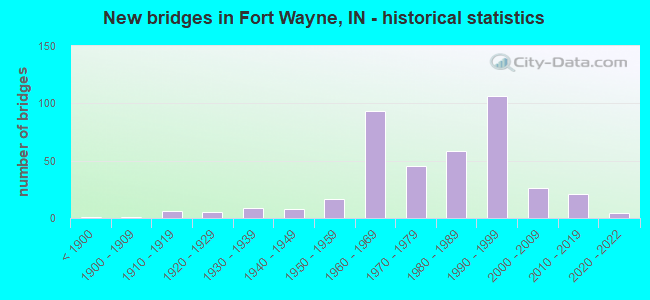
- New bridges - historical statistics
- 1Before 1900
- 11900-1909
- 61910-1919
- 51920-1929
- 91930-1939
- 81940-1949
- 171950-1959
- 931960-1969
- 451970-1979
- 581980-1989
- 1061990-1999
- 262000-2009
- 212010-2019
- 42020-2022
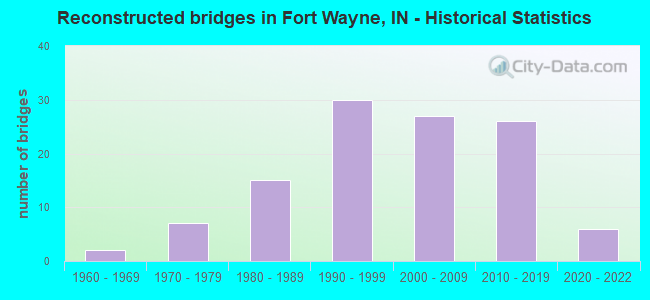
- Reconstructed bridges - Historical Statistics
- 21960-1969
- 71970-1979
- 151980-1989
- 301990-1999
- 272000-2009
- 262010-2019
- 62020-2022
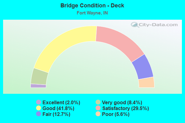
- Bridge Condition - Deck
- 2.0%Excellent
- 8.4%Very good
- 41.8%Good
- 29.5%Satisfactory
- 12.7%Fair
- 5.6%Poor
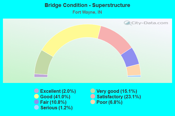
- Bridge Condition - Superstructure
- 2.0%Excellent
- 15.1%Very good
- 41.0%Good
- 23.1%Satisfactory
- 10.8%Fair
- 6.8%Poor
- 1.2%Serious
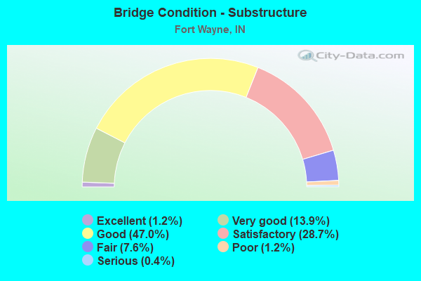
- Bridge Condition - Substructure
- 1.2%Excellent
- 13.9%Very good
- 47.0%Good
- 28.7%Satisfactory
- 7.6%Fair
- 1.2%Poor
- 0.4%Serious
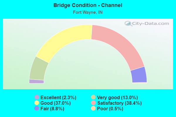
- Bridge Condition - Channel
- 2.3%Excellent
- 13.0%Very good
- 37.0%Good
- 38.4%Satisfactory
- 8.8%Fair
- 0.5%Poor
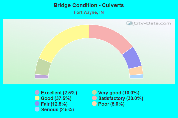
- Bridge Condition - Culverts
- 2.5%Excellent
- 10.0%Very good
- 37.5%Good
- 30.0%Satisfactory
- 12.5%Fair
- 5.0%Poor
- 2.5%Serious
Find on map >> Show street view
Structure Number: 32847, Location: 02.53 E US 27 (Lat: 40.999531, Lng: -85.043114), Route carried "under" structure: Interstate 469, Year Built: 1989, Structure Length: 0. m, Average Daily Traffic: 8,649 (year 2019), Truck Traffic: 34%, Features Intersected: I-469 EB, Facility Carried by Structure: WAYNE TRACE ROAD
Minimum Vertical Clearance: 5.79m (19.00ft), Kilometerpoint: 22.483, Lanes on structure: 2, Lanes under structure: 4, Material/Design: Steel continuous, Design/Construction: Stringer/Multi-beam, Length of Maximum Span: 31.4m (103.0ft)
Find on map >> Show street view
Structure Number: 32847, Location: 02.53 E US 27 (Lat: 40.999531, Lng: -85.043114), Route carried "under" structure: Interstate 469, Year Built: 1989, Structure Length: 0. m, Average Daily Traffic: 8,649 (year 2019), Truck Traffic: 34%, Features Intersected: I-469 WB, Facility Carried by Structure: WAYNE TRACE ROAD
Minimum Vertical Clearance: 5.79m (19.00ft), Kilometerpoint: 22.483, Lanes on structure: 2, Lanes under structure: 4, Material/Design: Steel continuous, Design/Construction: Stringer/Multi-beam, Length of Maximum Span: 31.4m (103.0ft)
Find on map >> Show street view
Structure Number: 32849, Location: 03.62 W US 30 (Lat: 41.019361, Lng: -85.025589), Route carried "under" structure: County highway , Year Built: 1989, Structure Length: 0. m, Average Daily Traffic: 501 (year 2019), Truck Traffic: 8%, Features Intersected: TILLMAN RD EB, Facility Carried by Structure: I-469 EB
Minimum Vertical Clearance: 4.40m (14.44ft), Kilometerpoint: 0.000, Lanes on structure: 2, Lanes under structure: 1, Material/Design: Steel continuous, Design/Construction: Stringer/Multi-beam, Length of Maximum Span: 17.5m (57.4ft)
Find on map >> Show street view
Structure Number: 32849, Location: 03.62 W US 30 (Lat: 41.019361, Lng: -85.025589), Route carried "under" structure: County highway , Year Built: 1989, Structure Length: 0. m, Average Daily Traffic: 530 (year 2019), Truck Traffic: 8%, Features Intersected: TILLMAN RD WB, Facility Carried by Structure: I-469 EB
Minimum Vertical Clearance: 4.40m (14.44ft), Kilometerpoint: 0.000, Lanes on structure: 2, Lanes under structure: 1, Material/Design: Steel continuous, Design/Construction: Stringer/Multi-beam, Length of Maximum Span: 17.5m (57.4ft)
Find on map >> Show street view
Structure Number: 4012, Location: 02.97 S US 24 (Lat: 40.992400, Lng: -85.268172), Route carried "under" structure: Interstate 69, Year Built: 1989, Structure Length: 0. m, Average Daily Traffic: 15,871 (year 2020), Truck Traffic: 19%, Features Intersected: I69 NB, Facility Carried by Structure: LOW. HUNTINGTON RD
Minimum Vertical Clearance: 5.05m (16.57ft), Kilometerpoint: 641.855, Lanes on structure: 3, Lanes under structure: 4, Material/Design: Steel continuous, Design/Construction: Stringer/Multi-beam, Length of Maximum Span: 36.9m (121.1ft)
Find on map >> Show street view
Structure Number: 4012, Location: 02.97 S US 24 (Lat: 40.992400, Lng: -85.268172), Route carried "under" structure: Interstate 69, Year Built: 1989, Structure Length: 0. m, Average Daily Traffic: 15,871 (year 2020), Truck Traffic: 19%, Features Intersected: I69 SB, Facility Carried by Structure: LOW. HUNTINGTON RD
Minimum Vertical Clearance: 4.93m (16.17ft), Kilometerpoint: 641.855, Lanes on structure: 3, Lanes under structure: 4, Material/Design: Steel continuous, Design/Construction: Stringer/Multi-beam, Length of Maximum Span: 36.9m (121.1ft)
Find on map >> Show street view
Structure Number: 4015, Location: 01.25 S US 24 (Lat: 41.015811, Lng: -85.254425), Route carried "under" structure: Interstate 69, Year Built: 1964, Structure Length: 0. m, Average Daily Traffic: 20,796 (year 2019), Truck Traffic: 18%, Features Intersected: I-69 NB, Facility Carried by Structure: YOHNE ROAD
Minimum Vertical Clearance: 4.93m (16.17ft), Kilometerpoint: 483.688, Lanes on structure: 2, Lanes under structure: 2, Material/Design: Steel continuous, Design/Construction: Stringer/Multi-beam, Length of Maximum Span: 21.3m (69.9ft)
Find on map >> Show street view
Structure Number: 4015, Location: 01.25 S US 24 (Lat: 41.015811, Lng: -85.254425), Route carried "under" structure: Interstate 69, Year Built: 1964, Structure Length: 0. m, Average Daily Traffic: 20,796 (year 2019), Truck Traffic: 18%, Features Intersected: I-69 SB, Facility Carried by Structure: YOHNE ROAD
Minimum Vertical Clearance: 4.93m (16.17ft), Kilometerpoint: 483.688, Lanes on structure: 2, Lanes under structure: 2, Material/Design: Steel continuous, Design/Construction: Stringer/Multi-beam, Length of Maximum Span: 21.3m (69.9ft)
Find on map >> Show street view
Structure Number: 4018, Location: 03.21 S SR 14 (Lat: 41.034039, Lng: -85.252281), Route carried "under" structure: US 24, Year Built: 1961, Structure Length: 0. m, Average Daily Traffic: 14,286 (year 2018), Truck Traffic: 20%, Features Intersected: US 24 WB, Facility Carried by Structure: I-69 NB
Minimum Vertical Clearance: 5.33m (17.49ft), Kilometerpoint: 7.838, Lanes on structure: 3, Lanes under structure: 6, Material/Design: Steel continuous, Design/Construction: Stringer/Multi-beam, Length of Maximum Span: 19.1m (62.7ft)
Find on map >> Show street view
Structure Number: 4018, Location: 03.21 S SR 14 (Lat: 41.034039, Lng: -85.252281), Route carried "under" structure: US 24, Year Built: 1961, Structure Length: 0. m, Average Daily Traffic: 14,286 (year 2018), Truck Traffic: 20%, Features Intersected: US 24 EB, Facility Carried by Structure: I-69 NB
Minimum Vertical Clearance: 5.33m (17.49ft), Kilometerpoint: 7.838, Lanes on structure: 3, Lanes under structure: 6, Material/Design: Steel continuous, Design/Construction: Stringer/Multi-beam, Length of Maximum Span: 19.1m (62.7ft)
Find on map >> Show street view
Structure Number: 4019, Location: 03.21 S SR 14 (Lat: 41.033950, Lng: -85.252594), Route carried "under" structure: US 24, Year Built: 1961, Structure Length: 0. m, Average Daily Traffic: 25,327 (year 2018), Truck Traffic: 12%, Features Intersected: US 24 WB, Facility Carried by Structure: I-69 SB
Minimum Vertical Clearance: 4.90m (16.08ft), Kilometerpoint: 7.805, Lanes on structure: 4, Lanes under structure: 7, Material/Design: Steel continuous, Design/Construction: Stringer/Multi-beam, Length of Maximum Span: 19.1m (62.7ft)
Find on map >> Show street view
Structure Number: 4019, Location: 03.21 S SR 14 (Lat: 41.033950, Lng: -85.252594), Route carried "under" structure: US 24, Year Built: 1961, Structure Length: 0. m, Average Daily Traffic: 25,327 (year 2018), Truck Traffic: 12%, Features Intersected: US 24 EB, Facility Carried by Structure: I-69 SB
Minimum Vertical Clearance: 4.90m (16.08ft), Kilometerpoint: 7.805, Lanes on structure: 4, Lanes under structure: 7, Material/Design: Steel continuous, Design/Construction: Stringer/Multi-beam, Length of Maximum Span: 19.1m (62.7ft)
Find on map >> Show street view
Structure Number: 4021, Location: 01.21 S SR 14 (Lat: 41.059889, Lng: -85.240083), Route carried "under" structure: Interstate 69, Year Built: 1961, Structure Length: 0. m, Average Daily Traffic: 52,522 (year 2019), Truck Traffic: 30%, Features Intersected: I-69 NB, Facility Carried by Structure: COVINGTON ROAD
Minimum Vertical Clearance: 5.08m (16.67ft), Kilometerpoint: 488.919, Lanes on structure: 2, Lanes under structure: 6, Material/Design: Steel continuous, Design/Construction: Stringer/Multi-beam, Length of Maximum Span: 28.4m (93.2ft)
Find on map >> Show street view
Structure Number: 4021, Location: 01.21 S SR 14 (Lat: 41.059889, Lng: -85.240083), Route carried "under" structure: Interstate 69, Year Built: 1961, Structure Length: 0. m, Average Daily Traffic: 52,522 (year 2019), Truck Traffic: 30%, Features Intersected: I-69 SB, Facility Carried by Structure: COVINGTON ROAD
Minimum Vertical Clearance: 5.08m (16.67ft), Kilometerpoint: 488.919, Lanes on structure: 2, Lanes under structure: 6, Material/Design: Steel continuous, Design/Construction: Stringer/Multi-beam, Length of Maximum Span: 28.4m (93.2ft)
Find on map >> Show street view
Structure Number: 4022, Location: 00.97 S SR-14 (Lat: 41.062400, Lng: -85.236589), Route carried "under" structure: County highway , Year Built: 1961, Structure Length: 0. m, Average Daily Traffic: 11,167 (year 2015), Truck Traffic: 5%, Features Intersected: HADLEY ROAD, Facility Carried by Structure: I-69 NB
Minimum Vertical Clearance: 4.29m (14.07ft), Kilometerpoint: 0.000, Lanes on structure: 3, Lanes under structure: 2, Material/Design: Steel continuous, Design/Construction: Stringer/Multi-beam, Length of Maximum Span: 16.8m (55.1ft)
Find on map >> Show street view
Structure Number: 4023, Location: 00.97 S SR-14 (Lat: 41.062661, Lng: -85.236589), Route carried "under" structure: County highway , Year Built: 1961, Structure Length: 0. m, Average Daily Traffic: 11,167 (year 2015), Truck Traffic: 5%, Features Intersected: HADLEY ROAD, Facility Carried by Structure: I-69 SB
Minimum Vertical Clearance: 4.29m (14.07ft), Kilometerpoint: 0.000, Lanes on structure: 3, Lanes under structure: 2, Material/Design: Steel continuous, Design/Construction: Stringer/Multi-beam, Length of Maximum Span: 16.8m (55.1ft)
Find on map >> Show street view
Structure Number: 4028, Location: 01.08 N SR 14 (Lat: 41.088811, Lng: -85.221108), Route carried "under" structure: Interstate 69, Year Built: 1960, Structure Length: 0. m, Average Daily Traffic: 35,174 (year 2018), Truck Traffic: 13%, Features Intersected: I-69 NB, Facility Carried by Structure: BASS ROAD
Minimum Vertical Clearance: 5.23m (17.16ft), Kilometerpoint: 492.604, Lanes on structure: 2, Lanes under structure: 6, Material/Design: Steel continuous, Design/Construction: Stringer/Multi-beam, Length of Maximum Span: 24.6m (80.7ft)
Find on map >> Show street view
Structure Number: 4028, Location: 01.08 N SR 14 (Lat: 41.088811, Lng: -85.221108), Route carried "under" structure: Interstate 69, Year Built: 1960, Structure Length: 0. m, Average Daily Traffic: 35,849 (year 2018), Truck Traffic: 13%, Features Intersected: I-69 SB, Facility Carried by Structure: BASS ROAD
Minimum Vertical Clearance: 5.23m (17.16ft), Kilometerpoint: 492.604, Lanes on structure: 2, Lanes under structure: 6, Material/Design: Steel continuous, Design/Construction: Stringer/Multi-beam, Length of Maximum Span: 24.6m (80.7ft)
Find on map >> Show street view
Structure Number: 40291, Location: 00.77 N US-24 (Lat: 41.045269, Lng: -85.252381), Route carried "under" structure: Interstate 69, Year Built: 2005, Structure Length: 0. m, Average Daily Traffic: 50,542 (year 2019), Truck Traffic: 18%, Features Intersected: I-69 NB, Facility Carried by Structure: ABOITE CENTER ROAD
Minimum Vertical Clearance: 5.08m (16.67ft), Kilometerpoint: 488.919, Lanes on structure: 2, Lanes under structure: 6, Material/Design: Prestressed concrete continuous, Design/Construction: Tee Beam, Length of Maximum Span: 26.4m (86.6ft)
Find on map >> Show street view
Structure Number: 40291, Location: 00.77 N US-24 (Lat: 41.045269, Lng: -85.252381), Route carried "under" structure: Interstate 69, Year Built: 2005, Structure Length: 0. m, Average Daily Traffic: 50,542 (year 2019), Truck Traffic: 20%, Features Intersected: I-69 SB, Facility Carried by Structure: ABOITE CENTER ROAD
Minimum Vertical Clearance: 5.08m (16.67ft), Kilometerpoint: 488.919, Lanes on structure: 2, Lanes under structure: 6, Material/Design: Prestressed concrete continuous, Design/Construction: Tee Beam, Length of Maximum Span: 26.4m (86.6ft)
Find on map >> Show street view
Structure Number: 403, Location: 00.48 S US 30 (Lat: 41.116650, Lng: -85.192406), Route carried "under" structure: Interstate 69, Year Built: 1960, Structure Length: 0. m, Average Daily Traffic: 30,914 (year 2020), Truck Traffic: 13%, Features Intersected: I-69 NB, Facility Carried by Structure: HILLEGAS ROAD
Minimum Vertical Clearance: 5.41m (17.75ft), Kilometerpoint: 496.483, Lanes on structure: 2, Lanes under structure: 3, Material/Design: Steel continuous, Design/Construction: Stringer/Multi-beam, Length of Maximum Span: 31.8m (104.3ft)
Find on map >> Show street view
Structure Number: 403, Location: 00.48 S US 30 (Lat: 41.116650, Lng: -85.192406), Route carried "under" structure: Interstate 69, Year Built: 1960, Structure Length: 0. m, Average Daily Traffic: 31,507 (year 2020), Truck Traffic: 13%, Features Intersected: I-69 SB, Facility Carried by Structure: HILLEGAS ROAD
Minimum Vertical Clearance: 5.41m (17.75ft), Kilometerpoint: 496.483, Lanes on structure: 2, Lanes under structure: 3, Material/Design: Steel continuous, Design/Construction: Stringer/Multi-beam, Length of Maximum Span: 31.8m (104.3ft)
Find on map >> Show street view
Structure Number: 4035, Location: 00.62 N SR 3 (Lat: 41.132600, Lng: -85.147500), Route carried "under" structure: City street , Year Built: 1992, Structure Length: 0. m, Average Daily Traffic: 8,611 (year 2020), Truck Traffic: 10%, Features Intersected: WASHINGTON CENTER ROAD W, Facility Carried by Structure: I-69 NB
Minimum Vertical Clearance: 5.31m (17.42ft), Kilometerpoint: 0.000, Lanes on structure: 3, Lanes under structure: 2, Material/Design: Prestressed concrete continuous, Design/Construction: Stringer/Multi-beam, Length of Maximum Span: 32.5m (106.6ft)
Find on map >> Show street view
Structure Number: 4035, Location: 00.62 N SR 3 (Lat: 41.132600, Lng: -85.147500), Route carried "under" structure: City street , Year Built: 1992, Structure Length: 0. m, Average Daily Traffic: 9,404 (year 2020), Truck Traffic: 10%, Features Intersected: WASHINGTON CENTER ROAD E, Facility Carried by Structure: I-69 NB
Minimum Vertical Clearance: 5.26m (17.26ft), Kilometerpoint: 0.000, Lanes on structure: 3, Lanes under structure: 2, Material/Design: Prestressed concrete continuous, Design/Construction: Stringer/Multi-beam, Length of Maximum Span: 32.5m (106.6ft)
Find on map >> Show street view
Structure Number: 4036, Location: 00.62 N SR 3 (Lat: 41.132561, Lng: -85.148033), Route carried "under" structure: City street , Year Built: 1992, Structure Length: 0. m, Average Daily Traffic: 9,404 (year 2020), Truck Traffic: 10%, Features Intersected: WASHINGTON CENTER ROAD E, Facility Carried by Structure: I-69 SB
Minimum Vertical Clearance: 5.28m (17.32ft), Kilometerpoint: 0.000, Lanes on structure: 3, Lanes under structure: 2, Material/Design: Prestressed concrete continuous, Design/Construction: Stringer/Multi-beam, Length of Maximum Span: 32.5m (106.6ft)
Find on map >> Show street view
Structure Number: 4036, Location: 00.62 N SR 3 (Lat: 41.132561, Lng: -85.148033), Route carried "under" structure: City street , Year Built: 1992, Structure Length: 0. m, Average Daily Traffic: 8,611 (year 2020), Truck Traffic: 10%, Features Intersected: WASHINGTON CENTER ROAD W, Facility Carried by Structure: I-69 SB
Minimum Vertical Clearance: 5.31m (17.42ft), Kilometerpoint: 0.000, Lanes on structure: 3, Lanes under structure: 2, Material/Design: Prestressed concrete continuous, Design/Construction: Stringer/Multi-beam, Length of Maximum Span: 32.5m (106.6ft)
Find on map >> Show street view
Structure Number: 40383, Location: 01.30 N SR-3 (Lat: 41.137831, Lng: -85.136253), Route carried "under" structure: Interstate 69, Year Built: 1960, Structure Length: 0. m, Average Daily Traffic: 35,492 (year 2021), Truck Traffic: 15%, Features Intersected: I-69 SB, Facility Carried by Structure: COLDWATER ROAD SB
Minimum Vertical Clearance: 4.93m (16.17ft), Kilometerpoint: 502.115, Lanes on structure: 4, Lanes under structure: 5, Material/Design: Steel continuous, Design/Construction: Stringer/Multi-beam, Length of Maximum Span: 24.1m (79.1ft)
Find on map >> Show street view
Structure Number: 40383, Location: 01.30 N SR-3 (Lat: 41.137831, Lng: -85.136253), Route carried "under" structure: Interstate 69, Year Built: 1960, Structure Length: 0. m, Average Daily Traffic: 35,492 (year 2021), Truck Traffic: 15%, Features Intersected: I-69 NB, Facility Carried by Structure: COLDWATER ROAD SB
Minimum Vertical Clearance: 4.93m (16.17ft), Kilometerpoint: 502.115, Lanes on structure: 4, Lanes under structure: 5, Material/Design: Steel continuous, Design/Construction: Stringer/Multi-beam, Length of Maximum Span: 24.1m (79.1ft)
Find on map >> Show street view
Structure Number: 40385, Location: 01.36 N SR 3 (Lat: 41.137869, Lng: -85.136139), Route carried "under" structure: Interstate 69, Year Built: 1960, Structure Length: 0. m, Average Daily Traffic: 29,395 (year 2020), Truck Traffic: 14%, Features Intersected: I-69 SB, Facility Carried by Structure: COLDWATER ROAD NB
Minimum Vertical Clearance: 5.46m (17.91ft), Kilometerpoint: 502.115, Lanes on structure: 3, Lanes under structure: 8, Material/Design: Steel continuous, Design/Construction: Stringer/Multi-beam, Length of Maximum Span: 27.7m (90.9ft)
Find on map >> Show street view
Structure Number: 40385, Location: 01.36 N SR 3 (Lat: 41.137869, Lng: -85.136139), Route carried "under" structure: Interstate 69, Year Built: 1960, Structure Length: 0. m, Average Daily Traffic: 29,728 (year 2020), Truck Traffic: 14%, Features Intersected: I-69 NB, Facility Carried by Structure: COLDWATER ROAD NB
Minimum Vertical Clearance: 5.46m (17.91ft), Kilometerpoint: 502.115, Lanes on structure: 3, Lanes under structure: 8, Material/Design: Steel continuous, Design/Construction: Stringer/Multi-beam, Length of Maximum Span: 27.7m (90.9ft)
Find on map >> Show street view
Structure Number: 40387, Location: 00.00 ADJ I-69 (Lat: 41.140089, Lng: -85.135278), Route carried "under" structure: Ramp Interstate 69, Year Built: 1960, Structure Length: 0. m, Average Daily Traffic: 4,390 (year 2020), Truck Traffic: 3%, Features Intersected: I-69 SB OFF RAMP, Facility Carried by Structure: COLDWATER ROAD NB
Minimum Vertical Clearance: 4.90m (16.08ft), Kilometerpoint: 502.115, Lanes on structure: 2, Lanes under structure: 1, Material/Design: Concrete continuous, Design/Construction: Slab, Length of Maximum Span: 15.4m (50.5ft)
Find on map >> Show street view
Structure Number: 4042, Location: 01.00 S SR 1 (Lat: 41.164481, Lng: -85.106239), Route carried "under" structure: Interstate 69, Year Built: 1995, Structure Length: 0. m, Average Daily Traffic: 31,869 (year 2020), Truck Traffic: 31%, Features Intersected: I-69 NB, Facility Carried by Structure: WALLEN ROAD
Minimum Vertical Clearance: 5.41m (17.75ft), Kilometerpoint: 506.058, Lanes on structure: 2, Lanes under structure: 3, Material/Design: Steel continuous, Design/Construction: Stringer/Multi-beam, Length of Maximum Span: 42.7m (140.1ft)
Find on map >> Show street view
Structure Number: 4042, Location: 01.00 S SR 1 (Lat: 41.164481, Lng: -85.106239), Route carried "under" structure: Interstate 69, Year Built: 1995, Structure Length: 0. m, Average Daily Traffic: 30,368 (year 2020), Truck Traffic: 31%, Features Intersected: I-69 SB, Facility Carried by Structure: WALLEN ROAD
Minimum Vertical Clearance: 5.18m (16.99ft), Kilometerpoint: 506.058, Lanes on structure: 2, Lanes under structure: 3, Material/Design: Steel continuous, Design/Construction: Stringer/Multi-beam, Length of Maximum Span: 42.7m (140.1ft)
Find on map >> Show street view
Structure Number: 40441, Location: 01.43 N SR 1 (Lat: 41.200100, Lng: -85.104225), Route carried "under" structure: Interstate 69, Year Built: 2013, Structure Length: 0. m, Average Daily Traffic: 17,090 (year 2021), Truck Traffic: 22%, Features Intersected: I-69 NB, Facility Carried by Structure: UNION CHAPEL ROAD
Minimum Vertical Clearance: 5.23m (17.16ft), Kilometerpoint: 509.969, Lanes on structure: 2, Lanes under structure: 2, Material/Design: Prestressed concrete continuous, Design/Construction: Tee Beam, Length of Maximum Span: 27.2m (89.2ft)
Find on map >> Show street view
Structure Number: 40441, Location: 01.43 N SR 1 (Lat: 41.200100, Lng: -85.104225), Route carried "under" structure: Interstate 69, Year Built: 2013, Structure Length: 0. m, Average Daily Traffic: 17,284 (year 2021), Truck Traffic: 22%, Features Intersected: I-69 SB, Facility Carried by Structure: UNION CHAPEL ROAD
Minimum Vertical Clearance: 5.16m (16.93ft), Kilometerpoint: 509.969, Lanes on structure: 2, Lanes under structure: 2, Material/Design: Prestressed concrete continuous, Design/Construction: Tee Beam, Length of Maximum Span: 27.2m (89.2ft)
Find on map >> Show street view
Structure Number: 4045, Location: 02.95 N SR 1 (Lat: 41.221881, Lng: -85.103736), Route carried "under" structure: Interstate 69, Year Built: 1961, Structure Length: 0. m, Average Daily Traffic: 17,921 (year 2018), Truck Traffic: 35%, Features Intersected: I-69 NB, Facility Carried by Structure: HURSH ROAD
Minimum Vertical Clearance: 5.05m (16.57ft), Kilometerpoint: 512.415, Lanes on structure: 2, Lanes under structure: 2, Material/Design: Steel continuous, Design/Construction: Stringer/Multi-beam, Length of Maximum Span: 20.2m (66.3ft)
Find on map >> Show street view
Structure Number: 4045, Location: 02.95 N SR 1 (Lat: 41.221881, Lng: -85.103736), Route carried "under" structure: Interstate 69, Year Built: 1961, Structure Length: 0. m, Average Daily Traffic: 18,324 (year 2018), Truck Traffic: 35%, Features Intersected: I-69 SB, Facility Carried by Structure: HURSH ROAD
Minimum Vertical Clearance: 5.05m (16.57ft), Kilometerpoint: 512.415, Lanes on structure: 2, Lanes under structure: 2, Material/Design: Steel continuous, Design/Construction: Stringer/Multi-beam, Length of Maximum Span: 20.2m (66.3ft)
Find on map >> Show street view
Structure Number: 4048, Location: 04.07 N SR 1 (Lat: 41.236669, Lng: -85.095000), Route carried "under" structure: County highway , Year Built: 1961, Structure Length: 0. m, Average Daily Traffic: 1,392 (year 2021), Truck Traffic: 3%, Features Intersected: VANDOLAH ROAD, Facility Carried by Structure: I-69 NB
Minimum Vertical Clearance: 4.98m (16.34ft), Kilometerpoint: 0.000, Lanes on structure: 2, Lanes under structure: 2, Material/Design: Steel continuous, Design/Construction: Stringer/Multi-beam, Length of Maximum Span: 13.7m (44.9ft)
Find on map >> Show street view
Structure Number: 4049, Location: 04.07 N SR 1 (Lat: 41.236669, Lng: -85.095000), Route carried "under" structure: County highway , Year Built: 1961, Structure Length: 0. m, Average Daily Traffic: 1,392 (year 2021), Truck Traffic: 3%, Features Intersected: VANDOLAH ROAD, Facility Carried by Structure: I-69 SB
Minimum Vertical Clearance: 4.57m (14.99ft), Kilometerpoint: 0.000, Lanes on structure: 2, Lanes under structure: 2, Material/Design: Steel continuous, Design/Construction: Stringer/Multi-beam, Length of Maximum Span: 13.7m (44.9ft)
Find on map >> Show street view
Structure Number: 76021, Location: 01.35 N US 30 (Lat: 41.083961, Lng: -84.992850), Route carried "under" structure: US 24, Year Built: 1992, Structure Length: 0. m, Average Daily Traffic: 8,852 (year 2020), Truck Traffic: 39%, Features Intersected: US 24 WB, Facility Carried by Structure: I-469 SB
Minimum Vertical Clearance: 5.23m (17.16ft), Kilometerpoint: 50.195, Lanes on structure: 3, Lanes under structure: 3, Material/Design: Steel continuous, Design/Construction: Stringer/Multi-beam, Length of Maximum Span: 38.1m (125.0ft)
Find on map >> Show street view
Structure Number: 76021, Location: 01.35 N US 30 (Lat: 41.083961, Lng: -84.992850), Route carried "under" structure: US 24, Year Built: 1992, Structure Length: 0. m, Average Daily Traffic: 8,500 (year 2020), Truck Traffic: 39%, Features Intersected: US 24 EB, Facility Carried by Structure: I-469 SB
Minimum Vertical Clearance: 5.23m (17.16ft), Kilometerpoint: 50.195, Lanes on structure: 3, Lanes under structure: 3, Material/Design: Steel continuous, Design/Construction: Stringer/Multi-beam, Length of Maximum Span: 38.1m (125.0ft)
Find on map >> Show street view
Structure Number: 7607, Location: 01.10 S SR 37 (Lat: 41.121450, Lng: -84.995644), Route carried "under" structure: Interstate 469, Year Built: 1991, Structure Length: 0. m, Average Daily Traffic: 17,060 (year 2021), Truck Traffic: 24%, Features Intersected: I-469 NB, Facility Carried by Structure: STELLHORN ROAD
Minimum Vertical Clearance: 5.46m (17.91ft), Kilometerpoint: 37.675, Lanes on structure: 2, Lanes under structure: 4, Material/Design: Steel continuous, Design/Construction: Stringer/Multi-beam, Length of Maximum Span: 28.7m (94.2ft)
Find on map >> Show street view
Structure Number: 7607, Location: 01.10 S SR 37 (Lat: 41.121450, Lng: -84.995644), Route carried "under" structure: Interstate 469, Year Built: 1991, Structure Length: 0. m, Average Daily Traffic: 17,060 (year 2021), Truck Traffic: 24%, Features Intersected: I-469 SB, Facility Carried by Structure: STELLHORN ROAD
Minimum Vertical Clearance: 5.46m (17.91ft), Kilometerpoint: 37.675, Lanes on structure: 2, Lanes under structure: 4, Material/Design: Steel continuous, Design/Construction: Stringer/Multi-beam, Length of Maximum Span: 28.7m (94.2ft)
Find on map >> Show street view
Structure Number: 761, Location: 03.62 W US 30 (Lat: 41.019319, Lng: -85.025803), Route carried "under" structure: County highway , Year Built: 1989, Structure Length: 0. m, Average Daily Traffic: 501 (year 2019), Truck Traffic: 8%, Features Intersected: TILLMAN RD EB, Facility Carried by Structure: I-469 WB
Minimum Vertical Clearance: 4.40m (14.44ft), Kilometerpoint: 0.000, Lanes on structure: 2, Lanes under structure: 1, Material/Design: Steel continuous, Design/Construction: Stringer/Multi-beam, Length of Maximum Span: 17.5m (57.4ft)
Find on map >> Show street view
Structure Number: 761, Location: 03.62 W US 30 (Lat: 41.019319, Lng: -85.025803), Route carried "under" structure: County highway , Year Built: 1989, Structure Length: 0. m, Average Daily Traffic: 530 (year 2019), Truck Traffic: 8%, Features Intersected: TILLMAN RD WB, Facility Carried by Structure: I-469 WB
Minimum Vertical Clearance: 4.40m (14.44ft), Kilometerpoint: 0.000, Lanes on structure: 2, Lanes under structure: 1, Material/Design: Steel continuous, Design/Construction: Stringer/Multi-beam, Length of Maximum Span: 17.5m (57.4ft)
Find on map >> Show street view
Structure Number: 7616, Location: 03.65 N US 24 (Lat: 41.133500, Lng: -85.007247), Route carried "under" structure: State highway 37, Year Built: 1992, Structure Length: 0. m, Average Daily Traffic: 14,665 (year 2021), Truck Traffic: 6%, Features Intersected: SR 37, Facility Carried by Structure: I-469 NB
Minimum Vertical Clearance: 5.08m (16.67ft), Kilometerpoint: 0.016, Lanes on structure: 2, Lanes under structure: 4, Material/Design: Steel continuous, Design/Construction: Stringer/Multi-beam, Length of Maximum Span: 37.3m (122.4ft)
Find on map >> Show street view
Structure Number: 7617, Location: 03.65 N US 24 (Lat: 41.133389, Lng: -85.007361), Route carried "under" structure: State highway 37, Year Built: 1992, Structure Length: 0. m, Average Daily Traffic: 14,665 (year 2021), Truck Traffic: 6%, Features Intersected: SR 37, Facility Carried by Structure: I-469 SB
Minimum Vertical Clearance: 5.11m (16.77ft), Kilometerpoint: 0.000, Lanes on structure: 2, Lanes under structure: 4, Material/Design: Steel continuous, Design/Construction: Stringer/Multi-beam, Length of Maximum Span: 37.3m (122.4ft)
Find on map >> Show street view
Structure Number: 7618, Location: 00.34 N SR 37 (Lat: 41.136650, Lng: -85.012436), Route carried "under" structure: Interstate 469, Year Built: 1992, Structure Length: 0. m, Average Daily Traffic: 15,416 (year 2021), Truck Traffic: 25%, Features Intersected: I-469 NB, Facility Carried by Structure: ST JOSEPH CTR RD
Minimum Vertical Clearance: 5.41m (17.75ft), Kilometerpoint: 39.912, Lanes on structure: 2, Lanes under structure: 4, Material/Design: Prestressed concrete continuous, Design/Construction: Stringer/Multi-beam, Length of Maximum Span: 31.1m (102.0ft)
Find on map >> Show street view
Structure Number: 7618, Location: 00.34 N SR 37 (Lat: 41.136650, Lng: -85.012436), Route carried "under" structure: Interstate 469, Year Built: 1992, Structure Length: 0. m, Average Daily Traffic: 15,416 (year 2021), Truck Traffic: 25%, Features Intersected: I-469 SB, Facility Carried by Structure: ST JOSEPH CTR RD
Minimum Vertical Clearance: 5.41m (17.75ft), Kilometerpoint: 39.912, Lanes on structure: 2, Lanes under structure: 4, Material/Design: Prestressed concrete continuous, Design/Construction: Stringer/Multi-beam, Length of Maximum Span: 31.1m (102.0ft)
Find on map >> Show street view
Structure Number: 7619, Location: 01.92 E SR 37 (Lat: 41.154200, Lng: -85.024939), Route carried "under" structure: City street , Year Built: 1992, Structure Length: 0. m, Average Daily Traffic: 1,592 (year 2015), Truck Traffic: 2%, Features Intersected: WHEELOCK ROAD, Facility Carried by Structure: I-469 EB
Minimum Vertical Clearance: 4.44m (14.57ft), Kilometerpoint: 0.000, Lanes on structure: 2, Lanes under structure: 2, Material/Design: Prestressed concrete continuous, Design/Construction: Stringer/Multi-beam, Length of Maximum Span: 21.2m (69.6ft)
Find on map >> Show street view
Structure Number: 762, Location: 01.92 E SR 37 (Lat: 41.154331, Lng: -85.024939), Route carried "under" structure: City street , Year Built: 1992, Structure Length: 0. m, Average Daily Traffic: 1,592 (year 2015), Truck Traffic: 25%, Features Intersected: Wheelock Rd., Facility Carried by Structure: I-469 WB
Minimum Vertical Clearance: 4.42m (14.50ft), Kilometerpoint: 0.000, Lanes on structure: 2, Lanes under structure: 2, Material/Design: Prestressed concrete continuous, Design/Construction: Stringer/Multi-beam, Length of Maximum Span: 21.2m (69.6ft)
Find on map >> Show street view
Structure Number: 7621, Location: 03.99 E SR-37 (Lat: 41.159811, Lng: -85.063783), Route carried "under" structure: City street , Year Built: 1993, Structure Length: 0. m, Average Daily Traffic: 6,319 (year 2020), Truck Traffic: 5%, Features Intersected: Maplecrest Road SB, Facility Carried by Structure: I-469 EB
Minimum Vertical Clearance: 5.05m (16.57ft), Kilometerpoint: 0.000, Lanes on structure: 3, Lanes under structure: 5, Material/Design: Steel continuous, Design/Construction: Stringer/Multi-beam, Length of Maximum Span: 29.7m (97.4ft)
Find on map >> Show street view
Structure Number: 7621, Location: 03.99 E SR-37 (Lat: 41.159811, Lng: -85.063783), Route carried "under" structure: City street , Year Built: 1993, Structure Length: 0. m, Average Daily Traffic: 4,954 (year 2020), Truck Traffic: 5%, Features Intersected: Maplecrest Road NB, Facility Carried by Structure: I-469 EB
Minimum Vertical Clearance: 5.05m (16.57ft), Kilometerpoint: 0.000, Lanes on structure: 3, Lanes under structure: 5, Material/Design: Steel continuous, Design/Construction: Stringer/Multi-beam, Length of Maximum Span: 29.7m (97.4ft)
Find on map >> Show street view
Structure Number: 7622, Location: 03.99 E SR-37 (Lat: 41.159981, Lng: -85.063789), Route carried "under" structure: City street , Year Built: 1993, Structure Length: 0. m, Average Daily Traffic: 6,319 (year 2020), Truck Traffic: 5%, Features Intersected: Maplecrest Road SB, Facility Carried by Structure: I-469 WB
Minimum Vertical Clearance: 5.33m (17.49ft), Kilometerpoint: 0.000, Lanes on structure: 3, Lanes under structure: 5, Material/Design: Steel continuous, Design/Construction: Stringer/Multi-beam, Length of Maximum Span: 29.7m (97.4ft)
Find on map >> Show street view
Structure Number: 7622, Location: 03.99 E SR-37 (Lat: 41.159981, Lng: -85.063789), Route carried "under" structure: City street , Year Built: 1993, Structure Length: 0. m, Average Daily Traffic: 4,954 (year 2020), Truck Traffic: 5%, Features Intersected: Maplecrest Road NB, Facility Carried by Structure: I-469 WB
Minimum Vertical Clearance: 5.33m (17.49ft), Kilometerpoint: 0.000, Lanes on structure: 3, Lanes under structure: 5, Material/Design: Steel continuous, Design/Construction: Stringer/Multi-beam, Length of Maximum Span: 29.7m (97.4ft)
Find on map >> Show street view
Structure Number: 7626, Location: 04.33 W SR-37 (Lat: 41.161661, Lng: -85.070000), Route carried "under" structure: City street , Year Built: 1994, Structure Length: 0. m, Average Daily Traffic: 118 (year 2004), Truck Traffic: 10%, Features Intersected: ST JOE ROAD, Facility Carried by Structure: I-469 EB
Minimum Vertical Clearance: 4.62m (15.16ft), Kilometerpoint: 0.000, Lanes on structure: 3, Lanes under structure: 2, Material/Design: Prestressed concrete continuous, Design/Construction: Tee Beam, Length of Maximum Span: 29.6m (97.1ft)
Find on map >> Show street view
Structure Number: 7627, Location: 04.33 W SR-37 (Lat: 41.161831, Lng: -85.069808), Route carried "under" structure: City street , Year Built: 1994, Structure Length: 0. m, Average Daily Traffic: 118 (year 2004), Truck Traffic: 2%, Features Intersected: ST JOE ROAD, Facility Carried by Structure: I-469 WB
Minimum Vertical Clearance: 4.47m (14.67ft), Kilometerpoint: 0.000, Lanes on structure: 3, Lanes under structure: 2, Material/Design: Prestressed concrete continuous, Design/Construction: Tee Beam, Length of Maximum Span: 29.6m (97.1ft)
Find on map >> Show street view
Structure Number: 763, Location: 00.46 E I-69 (Lat: 41.168069, Lng: -85.095628), Route carried "under" structure: City street , Year Built: 1994, Structure Length: 0. m, Average Daily Traffic: 9,303 (year 2020), Truck Traffic: 1%, Features Intersected: Leo Rd. (Clinton St.), Facility Carried by Structure: I-469 EB
Minimum Vertical Clearance: 5.26m (17.26ft), Kilometerpoint: 0.000, Lanes on structure: 2, Lanes under structure: 2, Material/Design: Prestressed concrete continuous, Design/Construction: Tee Beam, Length of Maximum Span: 32.4m (106.3ft)
Find on map >> Show street view
Structure Number: 7631, Location: 00.46 E I-69 (Lat: 41.168219, Lng: -85.095397), Route carried "under" structure: City street , Year Built: 1994, Structure Length: 0. m, Average Daily Traffic: 9,303 (year 2020), Truck Traffic: 1%, Features Intersected: Leo Rd. (Clinton St.), Facility Carried by Structure: I-469 WB
Minimum Vertical Clearance: 5.21m (17.09ft), Kilometerpoint: 0.000, Lanes on structure: 2, Lanes under structure: 2, Material/Design: Prestressed concrete continuous, Design/Construction: Tee Beam, Length of Maximum Span: 32.4m (106.3ft)
Find on map >> Show street view
Structure Number: 7635, Location: 00.46 W I-69 (Lat: 41.164389, Lng: -85.108003), Route carried "under" structure: County highway , Year Built: 1994, Structure Length: 0. m, Average Daily Traffic: 3,303 (year 2021), Features Intersected: WALLEN ROAD, Facility Carried by Structure: I-469 WB TO I-69 S
Minimum Vertical Clearance: 4.47m (14.67ft), Kilometerpoint: 0.000, Lanes on structure: 1, Lanes under structure: 2, Material/Design: Prestressed concrete, Design/Construction: Tee Beam, Length of Maximum Span: 30.5m (100.1ft)
Find on map >> Show street view
Structure Number: 764, Location: 01.26 E I-69 (Lat: 41.168331, Lng: -85.104356), Route carried "under" structure: Interstate 69, Year Built: 1995, Structure Length: 0. m, Average Daily Traffic: 38,363 (year 2018), Truck Traffic: 31%, Features Intersected: I-69 NB
Minimum Vertical Clearance: 5.31m (17.42ft), Kilometerpoint: 184.672, Lanes on structure: 1, Lanes under structure: 5, Material/Design: Prestressed concrete continuous, Design/Construction: Tee Beam, Length of Maximum Span: 40.1m (131.6ft)
Find on map >> Show street view
Structure Number: 764, Location: 01.26 E I-69 (Lat: 41.168331, Lng: -85.104356), Route carried "under" structure: Interstate 69, Year Built: 1995, Structure Length: 0. m, Average Daily Traffic: 38,363 (year 2018), Truck Traffic: 31%, Features Intersected: I-69 SB
Minimum Vertical Clearance: 5.31m (17.42ft), Kilometerpoint: 184.672, Lanes on structure: 1, Lanes under structure: 5, Material/Design: Prestressed concrete continuous, Design/Construction: Tee Beam, Length of Maximum Span: 40.1m (131.6ft)
Find on map >> Show street view
Structure Number: 7641, Location: 01.26 E I-69 (Lat: 41.168481, Lng: -85.104272), Route carried "under" structure: Interstate 469, Year Built: 1995, Structure Length: 0. m, Average Daily Traffic: 37,117 (year 2018), Truck Traffic: 31%, Features Intersected: I-69 NB
Minimum Vertical Clearance: 5.46m (17.91ft), Kilometerpoint: 184.688, Lanes on structure: 3, Lanes under structure: 7, Material/Design: Prestressed concrete continuous, Design/Construction: Tee Beam, Length of Maximum Span: 40.1m (131.6ft)
Find on map >> Show street view
Structure Number: 7641, Location: 01.26 E I-69 (Lat: 41.168481, Lng: -85.104272), Route carried "under" structure: Interstate 469, Year Built: 1995, Structure Length: 0. m, Average Daily Traffic: 39,609 (year 2018), Truck Traffic: 31%, Features Intersected: I-69 SB
Minimum Vertical Clearance: 5.46m (17.91ft), Kilometerpoint: 184.688, Lanes on structure: 3, Lanes under structure: 7, Material/Design: Prestressed concrete continuous, Design/Construction: Tee Beam, Length of Maximum Span: 40.1m (131.6ft)
Find on map >> Show street view
Structure Number: 76576, Location: 02.51 N SR-3 (Lat: 41.147850, Lng: -85.116975), Route carried "under" structure: Interstate 69, Year Built: 2007, Structure Length: 0. m, Average Daily Traffic: 22,118 (year 2020), Truck Traffic: 12%, Features Intersected: I-69 NB, Facility Carried by Structure: AUBURN ROAD
Minimum Vertical Clearance: 5.08m (16.67ft), Kilometerpoint: 503.966, Lanes on structure: 2, Lanes under structure: 3, Material/Design: Prestressed concrete continuous, Design/Construction: Tee Beam, Length of Maximum Span: 27.5m (90.2ft)
Find on map >> Show street view
Structure Number: 76576, Location: 02.51 N SR-3 (Lat: 41.147850, Lng: -85.116975), Route carried "under" structure: Interstate 69, Year Built: 2007, Structure Length: 0. m, Average Daily Traffic: 22,259 (year 2020), Truck Traffic: 12%, Features Intersected: I-69 SB, Facility Carried by Structure: AUBURN ROAD
Minimum Vertical Clearance: 5.08m (16.67ft), Kilometerpoint: 503.966, Lanes on structure: 2, Lanes under structure: 3, Material/Design: Prestressed concrete continuous, Design/Construction: Tee Beam, Length of Maximum Span: 27.5m (90.2ft)
Find on map >> Show street view
Structure Number: 76824, Location: 01.65 S US-30 (Lat: 41.103039, Lng: -85.206489), Route carried "under" structure: Interstate 69, Year Built: 2006, Structure Length: 0. m, Average Daily Traffic: 35,303 (year 2018), Truck Traffic: 20%, Features Intersected: I-69 SB, Facility Carried by Structure: LEESBURG ROAD
Minimum Vertical Clearance: 5.03m (16.50ft), Kilometerpoint: 494.600, Lanes on structure: 2, Lanes under structure: 6, Material/Design: Steel continuous, Design/Construction: Stringer/Multi-beam, Length of Maximum Span: 25.8m (84.6ft)
Find on map >> Show street view
Structure Number: 76824, Location: 01.65 S US-30 (Lat: 41.103039, Lng: -85.206489), Route carried "under" structure: Interstate 69, Year Built: 2006, Structure Length: 0. m, Average Daily Traffic: 35,852 (year 2018), Truck Traffic: 20%, Features Intersected: I-69 NB, Facility Carried by Structure: LEESBURG ROAD
Minimum Vertical Clearance: 5.03m (16.50ft), Kilometerpoint: 494.600, Lanes on structure: 2, Lanes under structure: 6, Material/Design: Steel continuous, Design/Construction: Stringer/Multi-beam, Length of Maximum Span: 25.8m (84.6ft)
Find on map >> Show street view
Structure Number: 200336, Location: 01.00 E OF ABOITE RD (Lat: 40.973261, Lng: -85.314383), Route carried "under" structure: ServiceCounty highway , Year Built: 1986, Structure Length: 0. m, Average Daily Traffic: 100 (year 2014), Truck Traffic: 1%, Features Intersected: PRIVATE ROAD, Facility Carried by Structure: FOGWELL PKWY
Minimum Vertical Clearance: 7.14m (23.43ft), Kilometerpoint: 0.000, Lanes on structure: 4, Lanes under structure: 2, Material/Design: Steel continuous, Design/Construction: Stringer/Multi-beam, Length of Maximum Span: 34.4m (112.9ft)
Find on map >> Show street view
Structure Number: 200339, Location: 00.20 N OF WINCHESTER RD (Lat: 41.029050, Lng: -85.147575), Route carried "under" structure: ServiceCity street , Year Built: 1972, Structure Length: 0. m, Average Daily Traffic: 1 (year 2012), Truck Traffic: 5%, Features Intersected: PARK DRIVE, Facility Carried by Structure: AIRPORT EXPY
Minimum Vertical Clearance: 3.25m (10.66ft), Kilometerpoint: 0.000, Lanes on structure: 4, Lanes under structure: 2, Material/Design: Prestressed concrete continuous, Design/Construction: Stringer/Multi-beam, Length of Maximum Span: 20.7m (67.9ft)