Bridge Statistics for Harrisonburg, Virginia (VA)
Condition, Traffic, Stress, Structural Evaluation, Project Costs
- National Bridge Inventory (NBI) Statistics
- 91Number of bridges
- 860ft / 262mTotal length
- $10,568,000Total costs
- 1,223,649Total average daily traffic
- 177,933Total average daily truck traffic
- National Bridge Inventory (NBI) Registered Bridges for Harrisonburg
- No street view available for this location
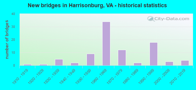
- New bridges - historical statistics
- 11910-1919
- 11920-1929
- 51930-1939
- 21940-1949
- 91950-1959
- 341960-1969
- 121970-1979
- 21980-1989
- 181990-1999
- 32000-2009
- 42010-2019
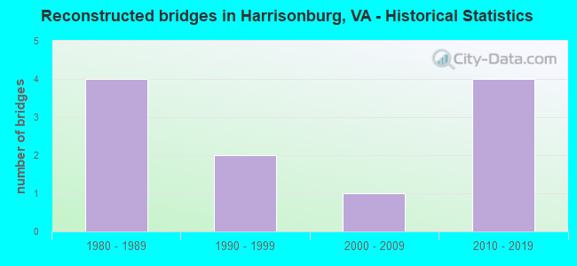
- Reconstructed bridges - Historical Statistics
- 41980-1989
- 21990-1999
- 12000-2009
- 42010-2019
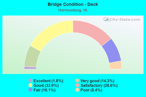
- Bridge Condition - Deck
- 1.8%Excellent
- 14.3%Very good
- 33.9%Good
- 28.6%Satisfactory
- 16.1%Fair
- 5.4%Poor
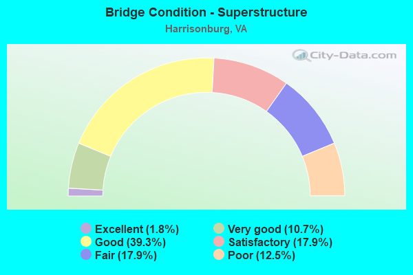
- Bridge Condition - Superstructure
- 1.8%Excellent
- 10.7%Very good
- 39.3%Good
- 17.9%Satisfactory
- 17.9%Fair
- 12.5%Poor
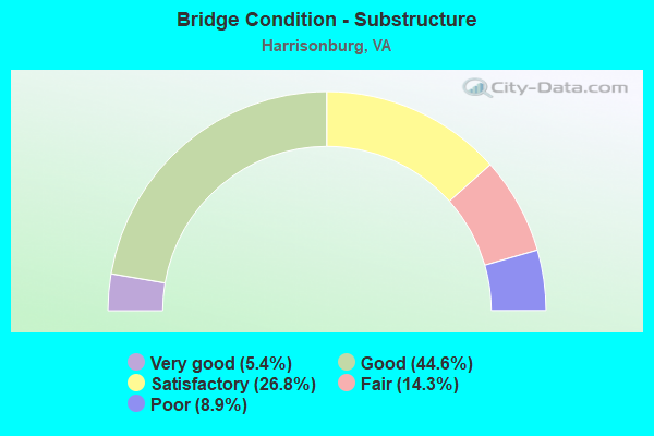
- Bridge Condition - Substructure
- 5.4%Very good
- 44.6%Good
- 26.8%Satisfactory
- 14.3%Fair
- 8.9%Poor
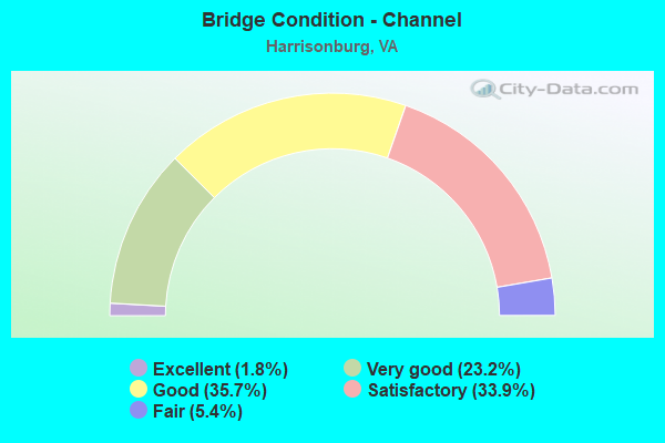
- Bridge Condition - Channel
- 1.8%Excellent
- 23.2%Very good
- 35.7%Good
- 33.9%Satisfactory
- 5.4%Fair
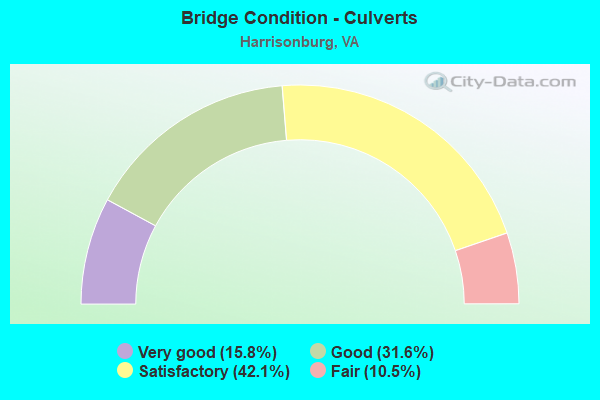
- Bridge Condition - Culverts
- 15.8%Very good
- 31.6%Good
- 42.1%Satisfactory
- 10.5%Fair
Find on map >> Show street view
Structure Number: 325, Location: 00.63FR27NBL/0.62TO14STBR (Lat: 38.865936, Lng: -77.051736), Route carried "on" structure: Ramp Interstate 395, Year Built: 1976, Status: Open, Structure Length: 7.10m (23.29ft), Average Daily Traffic: 14,312 (year 2020), Average Future Daily Traffic: 18,386 (year 2040), Design Load: HS 20, Features Intersected: NB RWY G O RT 110;J D HY
Minimum Vertical Clearance: 30+ m (98+ ft), Kilometerpoint: 14.690, Lanes on structure: 1, Lanes under structure: 9, Base Highway Network: Yes, Owner: State Highway Agency, Approaching Roadway Width: 11.7m (38.4ft), Material/Design: Steel, Design/Construction: Stringer/Multi-beam, Number Of Spans In Main Unit: 2, Length of Maximum Span: 36.0m (118.1ft), Curb or Sidewalk Widths: Left: 0.5m (1.6ft), Right: 0.2m (0.7ft), Curb-To-Curb Width: 10.1m (33.1ft), Out-to-Out Width: 10.1m (33.1ft)
Condition: Deck: Satisfactory, Superstructure: Satisfactory, Substructure: Satisfactory, Operating Rating: 58.6 metric tons, Method Used To Determine Operating Rating: Load and Resistance Factor (LRFR), Inventory Rating: 45.2 metric tons, Method Used To Determine Inventory Rating: Load and Resistance Factor (LRFR), Structural Evaluation: Equal to present minimum criteria, Deck Geometry: Superior to present desirable criteria, Underclear: High priority of replacement, Approach Roadway Alignment: Better than present minimum criteria, Length Of Structure Improvement: 7.62m (25.00ft), Designated Inspection Frequency: Every 24 months, Inspection Date: May 2020, Bridge Improvement Cost: $275,000, Roadway Improvement Cost: $20,000, Total Project Cost: $300,000 ( Estimate for 2014), Deck Structure Type: Concrete Cast-file-Place, Wearing Surface/Protective System: Wearing Surface: Monolithic Concrete
Find on map >> Show street view
Structure Number: 2045, Location: 0.28 RT 716 - 0.84 RT 688 (Lat: 38.244236, Lng: -79.334875), Route carried "on" structure: County highway 629, Year Built: 1964, Status: Open, Structure Length: 1.97m (6.46ft), Average Daily Traffic: 851 (year 2020), Truck Traffic: 3%, Average Future Daily Traffic: 1,031 (year 2040), Design Load: HS 20, Features Intersected: RAMSEY DRAFT, Facility Carried by Structure: DEERFIELD VALLEYRD
Minimum Vertical Clearance: 30+ m (98+ ft), Kilometerpoint: 14.912, Lanes on structure: 2, Owner: State Highway Agency, Approaching Roadway Width: 6.3m (20.7ft), Material/Design: Steel, Design/Construction: Stringer/Multi-beam, Number Of Spans In Main Unit: 1, Length of Maximum Span: 18.2m (59.7ft), Curb or Sidewalk Widths: Left: 0.5m (1.6ft), Right: 0.5m (1.6ft), Curb-To-Curb Width: 8.9m (29.2ft), Out-to-Out Width: 9.5m (31.2ft)
Condition: Deck: Fair, Superstructure: Good, Substructure: Satisfactory, Channel: Very good, Operating Rating: 60.8 metric tons, Method Used To Determine Operating Rating: Load and Resistance Factor (LRFR), Inventory Rating: 47.2 metric tons, Method Used To Determine Inventory Rating: Load and Resistance Factor (LRFR), Structural Evaluation: Equal to present minimum criteria, Deck Geometry: Somewhat better than minimum adequacy, Waterway Adequacy: Better than present minimum criteria, Approach Roadway Alignment: Equal to present minimum criteria, Designated Inspection Frequency: Every 24 months, Inspection Date: December 2021, Deck Structure Type: Concrete Cast-file-Place, Wearing Surface/Protective System: Wearing Surface: Epoxy Overlay
Find on map >> Show street view
Structure Number: 15738, Location: 1.52 RT 718 - 1.97 RT 724 (Lat: 38.469478, Lng: -78.817025), Route carried "on" structure: ServiceCounty highway F238, Year Built: 1960, Status: Open, Structure Length: 1.16m (3.81ft), Average Daily Traffic: 1,227 (year 2018), Average Future Daily Traffic: 1,362 (year 2040), Design Load: HS 20, Features Intersected: TRIB DRY FORK
Minimum Vertical Clearance: 30+ m (98+ ft), Kilometerpoint: 5.685, Lanes on structure: 2, Owner: State Highway Agency, Approaching Roadway Width: 9.8m (32.2ft), Skew: 4 degrees, Material/Design: Concrete, Design/Construction: Culvert, Number Of Spans In Main Unit: 3, Length of Maximum Span: 2.4m (7.9ft)
Condition: Channel: Very good, Culverts: Good, Operating Rating: 54.4 metric tons, Method Used To Determine Operating Rating: Field evaluation and documented engineering judgment, Inventory Rating: 32.7 metric tons, Method Used To Determine Inventory Rating: Field evaluation and documented engineering judgment, Structural Evaluation: Better than present minimum criteria, Waterway Adequacy: Better than present minimum criteria, Approach Roadway Alignment: Equal to present desirable criteria, Designated Inspection Frequency: Every 24 months, Inspection Date: April 2020
Find on map >> Show street view
Structure Number: 158, Location: 0.05 RT 772 - 0.07 RT 765 (Lat: 38.509828, Lng: -78.870542), Route carried "on" structure: State highway 42, Year Built: 1988, Status: Open, Structure Length: 1.46m (4.79ft), Average Daily Traffic: 9,911 (year 2020), Truck Traffic: 4%, Average Future Daily Traffic: 11,652 (year 2040), Design Load: HS 20, Features Intersected: LINVILLE CREEK
Minimum Vertical Clearance: 30+ m (98+ ft), Kilometerpoint: 373.611, Lanes on structure: 2, Base Highway Network: Yes, Owner: State Highway Agency, Approaching Roadway Width: 23.2m (76.1ft), Skew: 3 degrees, Material/Design: Concrete, Design/Construction: Culvert, Number Of Spans In Main Unit: 4, Length of Maximum Span: 3.0m (9.8ft)
Condition: Channel: Good, Culverts: Good, Operating Rating: 54.4 metric tons, Method Used To Determine Operating Rating: Field evaluation and documented engineering judgment, Inventory Rating: 32.7 metric tons, Method Used To Determine Inventory Rating: Field evaluation and documented engineering judgment, Structural Evaluation: Better than present minimum criteria, Waterway Adequacy: Better than present minimum criteria, Approach Roadway Alignment: Equal to present desirable criteria, Designated Inspection Frequency: Every 24 months, Inspection Date: Febuary 2021
Find on map >> Show street view
Structure Number: 15801, Location: 0.15 RT 721 -0.10 RT 42N (Lat: 38.524608, Lng: -78.860506), Route carried "on" structure: County highway 859, Year Built: 1952, Status: Posted for load, Structure Length: 1.52m (4.99ft), Average Daily Traffic: 121 (year 2018), Average Future Daily Traffic: 174 (year 2040), Design Load: HS 20+Mod, Features Intersected: WEST FORK LINVILLE CREEK, Facility Carried by Structure: LINDALE RD
Minimum Vertical Clearance: 30+ m (98+ ft), Kilometerpoint: 0.161, Lanes on structure: 2, Owner: State Highway Agency, Approaching Roadway Width: 6.7m (22.0ft), Material/Design: Steel, Design/Construction: Stringer/Multi-beam, Number Of Spans In Main Unit: 1, Length of Maximum Span: 15.2m (49.9ft), Curb or Sidewalk Widths: Left: 0.5m (1.6ft), Right: 0.5m (1.6ft), Curb-To-Curb Width: 7.3m (24.0ft), Out-to-Out Width: 8.2m (26.9ft)
Condition: Deck: Poor, Superstructure: Poor, Substructure: Poor, Channel: Satisfactory, Operating Rating: 27.2 metric tons, Method Used To Determine Operating Rating: Load Factor (LF), Inventory Rating: 16.3 metric tons, Method Used To Determine Inventory Rating: Load Factor (LF), Structural Evaluation: Meets minimum limits, Deck Geometry: Somewhat better than minimum adequacy, Waterway Adequacy: Equal to present minimum criteria, Approach Roadway Alignment: Equal to present desirable criteria, Bridge Posting: Required (Relationship of Operating Rating to Maximum Legal Load: > 39.9% below), Length Of Structure Improvement: 1.52m (4.99ft), Designated Inspection Frequency: Every 12 months, Inspection Date: August 2021, Bridge Improvement Cost: $196,000, Roadway Improvement Cost: $25,000, Total Project Cost: $230,000, Deck Structure Type: Concrete Cast-file-Place, Wearing Surface/Protective System: Wearing Surface: Bituminous
Find on map >> Show street view
Structure Number: 15816, Location: 2.90 RT 33-0.88 RT11 CONN (Lat: 38.469697, Lng: -78.817211), Route carried "on" structure: Interstate 81, Year Built: 1960, Status: Open, Structure Length: 1.46m (4.79ft), Average Daily Traffic: 44,300 (year 2020), Truck Traffic: 24%, Average Future Daily Traffic: 60,052 (year 2040), Design Load: HS 20, Features Intersected: TRIB DRY FORK
Minimum Vertical Clearance: 30+ m (98+ ft), Kilometerpoint: 402.861, Lanes on structure: 4, Base Highway Network: Yes, Owner: State Highway Agency, Approaching Roadway Width: 11.9m (39.0ft), Skew: 4 degrees, Material/Design: Concrete, Design/Construction: Culvert, Number Of Spans In Main Unit: 4, Length of Maximum Span: 2.4m (7.9ft)
Condition: Channel: Good, Culverts: Satisfactory, Operating Rating: 89.8 metric tons, Method Used To Determine Operating Rating: Load Factor (LF), Inventory Rating: 88.9 metric tons, Method Used To Determine Inventory Rating: Load Factor (LF), Structural Evaluation: Equal to present minimum criteria, Waterway Adequacy: Equal to present minimum criteria, Approach Roadway Alignment: Equal to present desirable criteria, Designated Inspection Frequency: Every 24 months, Inspection Date: April 2020
Find on map >> Show street view
Structure Number: 15819, Location: 0.33 RT 11 - 0.42 81 NBL (Lat: 38.481428, Lng: -78.811178), Route carried "on" structure: Ramp Interstate 81, Year Built: 1965, Status: Open, Structure Length: 7.83m (25.69ft), Average Daily Traffic: 1,089 (year 2020), Truck Traffic: 12%, Average Future Daily Traffic: 1,525 (year 2040), Design Load: HS 20+Mod, Features Intersected: I-81
Minimum Vertical Clearance: 30+ m (98+ ft), Kilometerpoint: 405.597, Lanes on structure: 1, Lanes under structure: 5, Base Highway Network: Yes, Owner: State Highway Agency, Approaching Roadway Width: 6.1m (20.0ft), Skew: 2 degrees, Material/Design: Steel, Design/Construction: Stringer/Multi-beam, Number Of Spans In Main Unit: 4, Length of Maximum Span: 21.6m (70.9ft), Curb or Sidewalk Widths: Left: 0.5m (1.6ft), Right: 0.5m (1.6ft), Curb-To-Curb Width: 6.1m (20.0ft), Out-to-Out Width: 7.6m (24.9ft)
Condition: Deck: Fair, Superstructure: Satisfactory, Substructure: Good, Operating Rating: 46.3 metric tons, Method Used To Determine Operating Rating: Load and Resistance Factor (LRFR), Inventory Rating: 35.4 metric tons, Method Used To Determine Inventory Rating: Load and Resistance Factor (LRFR), Structural Evaluation: Equal to present minimum criteria, Deck Geometry: Somewhat better than minimum adequacy, Underclear: Equal to present minimum criteria, Approach Roadway Alignment: Equal to present minimum criteria, Designated Inspection Frequency: Every 24 months, Inspection Date: August 2021, Bridge Improvement Cost: $48,000, Total Project Cost: $50,000, Deck Structure Type: Concrete Cast-file-Place, Wearing Surface/Protective System: Wearing Surface: Epoxy Overlay
Find on map >> Show street view
Structure Number: 15821, Location: 0.33 RT 11 - 0.42 81 NBL (Lat: 38.481611, Lng: -78.810092), Route carried "on" structure: Ramp Interstate 81, Year Built: 1965, Status: Open, Structure Length: 7.86m (25.79ft), Average Daily Traffic: 1,924 (year 2020), Average Future Daily Traffic: 2,694 (year 2040), Design Load: HS 20+Mod, Features Intersected: I-81
Minimum Vertical Clearance: 30+ m (98+ ft), Kilometerpoint: 405.613, Lanes on structure: 1, Lanes under structure: 5, Base Highway Network: Yes, Owner: State Highway Agency, Approaching Roadway Width: 6.1m (20.0ft), Skew: 2 degrees, Material/Design: Steel, Design/Construction: Stringer/Multi-beam, Number Of Spans In Main Unit: 4, Length of Maximum Span: 21.9m (71.9ft), Curb or Sidewalk Widths: Left: 0.5m (1.6ft), Right: 0.5m (1.6ft), Curb-To-Curb Width: 6.1m (20.0ft), Out-to-Out Width: 7.6m (24.9ft)
Condition: Deck: Satisfactory, Superstructure: Satisfactory, Substructure: Satisfactory, Operating Rating: 45.4 metric tons, Method Used To Determine Operating Rating: Load and Resistance Factor (LRFR), Inventory Rating: 35.4 metric tons, Method Used To Determine Inventory Rating: Load and Resistance Factor (LRFR), Structural Evaluation: Equal to present minimum criteria, Deck Geometry: Somewhat better than minimum adequacy, Underclear: Equal to present minimum criteria, Approach Roadway Alignment: Equal to present minimum criteria, Designated Inspection Frequency: Every 24 months, Inspection Date: August 2021, Bridge Improvement Cost: $72,000, Total Project Cost: $80,000, Deck Structure Type: Concrete Cast-file-Place, Wearing Surface/Protective System: Wearing Surface: Epoxy Overlay
Find on map >> Show street view
Structure Number: 15823, Location: 2.38 RT 257 -0.93 11 CONN (Lat: 38.389539, Lng: -78.914169), Route carried "on" structure: Interstate 81, Year Built: 1966, Status: Open, Structure Length: 4.21m (13.81ft), Average Daily Traffic: 25,332 (year 2020), Truck Traffic: 24%, Average Future Daily Traffic: 35,465 (year 2040), Design Load: HS 20+Mod, Features Intersected: BLACKS RUN
Minimum Vertical Clearance: 30+ m (98+ ft), Kilometerpoint: 390.987, Lanes on structure: 2, Base Highway Network: Yes, Owner: State Highway Agency, Approaching Roadway Width: 12.2m (40.0ft), Skew: 1 degrees, Material/Design: Prestressed concrete, Design/Construction: Stringer/Multi-beam, Number Of Spans In Main Unit: 3, Length of Maximum Span: 14.0m (45.9ft), Curb-To-Curb Width: 12.2m (40.0ft), Out-to-Out Width: 12.8m (42.0ft)
Condition: Deck: Satisfactory, Superstructure: Good, Substructure: Satisfactory, Channel: Good, Operating Rating: 77.1 metric tons, Method Used To Determine Operating Rating: Load and Resistance Factor (LRFR), Inventory Rating: 59.0 metric tons, Method Used To Determine Inventory Rating: Load and Resistance Factor (LRFR), Structural Evaluation: Equal to present minimum criteria, Deck Geometry: Better than present minimum criteria, Waterway Adequacy: Better than present minimum criteria, Approach Roadway Alignment: Equal to present desirable criteria, Designated Inspection Frequency: Every 24 months, Inspection Date: June 2021, Deck Structure Type: Concrete Cast-file-Place, Wearing Surface/Protective System: Wearing Surface: Latex Concrete
Find on map >> Show street view
Structure Number: 15824, Location: 2.38 RT 257 -0.93 11 CONN (Lat: 38.389569, Lng: -78.914469), Route carried "on" structure: Interstate 81, Year Built: 1966, Status: Open, Structure Length: 4.21m (13.81ft), Average Daily Traffic: 23,450 (year 2020), Truck Traffic: 23%, Average Future Daily Traffic: 32,830 (year 2040), Design Load: HS 20+Mod, Features Intersected: BLACKS RUN
Minimum Vertical Clearance: 30+ m (98+ ft), Kilometerpoint: 391.421, Lanes on structure: 2, Base Highway Network: Yes, Owner: State Highway Agency, Approaching Roadway Width: 12.2m (40.0ft), Skew: 1 degrees, Material/Design: Prestressed concrete, Design/Construction: Stringer/Multi-beam, Number Of Spans In Main Unit: 3, Length of Maximum Span: 14.0m (45.9ft), Curb-To-Curb Width: 12.2m (40.0ft), Out-to-Out Width: 12.8m (42.0ft)
Condition: Deck: Good, Superstructure: Good, Substructure: Satisfactory, Channel: Good, Operating Rating: 77.1 metric tons, Method Used To Determine Operating Rating: Load and Resistance Factor (LRFR), Inventory Rating: 59.0 metric tons, Method Used To Determine Inventory Rating: Load and Resistance Factor (LRFR), Structural Evaluation: Equal to present minimum criteria, Deck Geometry: Better than present minimum criteria, Waterway Adequacy: Better than present minimum criteria, Approach Roadway Alignment: Equal to present desirable criteria, Designated Inspection Frequency: Every 24 months, Inspection Date: June 2021, Deck Structure Type: Concrete Cast-file-Place, Wearing Surface/Protective System: Wearing Surface: Latex Concrete
Find on map >> Show street view
Structure Number: 15841, Location: 0.20 RT 11 - 0.15 RT 81 (Lat: 38.481750, Lng: -78.813069), Route carried "on" structure: Spur Interstate 81, Year Built: 1959, Status: Open, Structure Length: 1.28m (4.20ft), Average Daily Traffic: 5,235 (year 2020), Average Future Daily Traffic: 6,676 (year 2040), Design Load: HS 20, Features Intersected: DRY FORK
Minimum Vertical Clearance: 30+ m (98+ ft), Kilometerpoint: 405.709, Lanes on structure: 4, Base Highway Network: Yes, Owner: State Highway Agency, Approaching Roadway Width: 12.8m (42.0ft), Material/Design: Concrete, Design/Construction: Culvert, Number Of Spans In Main Unit: 4, Length of Maximum Span: 3.0m (9.8ft)
Condition: Channel: Satisfactory, Culverts: Satisfactory, Operating Rating: 44.5 metric tons, Method Used To Determine Operating Rating: Field evaluation and documented engineering judgment, Inventory Rating: 32.7 metric tons, Method Used To Determine Inventory Rating: Field evaluation and documented engineering judgment, Structural Evaluation: Equal to present minimum criteria, Waterway Adequacy: Equal to present desirable criteria, Approach Roadway Alignment: Equal to present desirable criteria, Designated Inspection Frequency: Every 24 months, Inspection Date: April 2020
Find on map >> Show street view
Structure Number: 16047, Location: 0.46 RT 988 - 0.60 RT 11 (Lat: 38.377142, Lng: -78.918856), Route carried "on" structure: County highway 704, Year Built: 1966, Status: Open, Structure Length: 9.45m (31.00ft), Average Daily Traffic: 3,732 (year 2020), Truck Traffic: 4%, Average Future Daily Traffic: 5,225 (year 2040), Design Load: HS 20+Mod, Features Intersected: I-81, Facility Carried by Structure: CECIL WAMPLER RD
Minimum Vertical Clearance: 30+ m (98+ ft), Kilometerpoint: 3.669, Lanes on structure: 2, Lanes under structure: 4, Owner: State Highway Agency, Approaching Roadway Width: 7.3m (24.0ft), Material/Design: Prestressed concrete, Design/Construction: Stringer/Multi-beam, Number Of Spans In Main Unit: 5, Length of Maximum Span: 20.7m (67.9ft), Curb or Sidewalk Widths: Left: 0.5m (1.6ft), Right: 0.5m (1.6ft), Curb-To-Curb Width: 7.3m (24.0ft), Out-to-Out Width: 8.8m (28.9ft)
Condition: Deck: Good, Superstructure: Good, Substructure: Satisfactory, Operating Rating: 64.4 metric tons, Method Used To Determine Operating Rating: Load and Resistance Factor (LRFR), Inventory Rating: 49.0 metric tons, Method Used To Determine Inventory Rating: Load and Resistance Factor (LRFR), Structural Evaluation: Equal to present minimum criteria, Deck Geometry: High priority of replacement, Underclear: Somewhat better than minimum adequacy, Approach Roadway Alignment: Better than present minimum criteria, Length Of Structure Improvement: 9.45m (31.00ft), Designated Inspection Frequency: Every 24 months, Inspection Date: May 2021, Bridge Improvement Cost: $43,000, Roadway Improvement Cost: $2,000, Total Project Cost: $45,000, Deck Structure Type: Concrete Cast-file-Place, Wearing Surface/Protective System: Wearing Surface: Epoxy Overlay
Find on map >> Show street view
Structure Number: 16069, Location: 0.07 RT 11 - 2.70 RT 725 (Lat: 38.497892, Lng: -78.804500), Route carried "on" structure: County highway 724, Year Built: 1976, Status: Open, Structure Length: 1.22m (4.00ft), Average Daily Traffic: 724 (year 2015), Average Future Daily Traffic: 1,086 (year 2040), Design Load: HS 20+Mod, Features Intersected: DRY FORK, Facility Carried by Structure: MELROSE RD
Minimum Vertical Clearance: 30+ m (98+ ft), Kilometerpoint: 4.344, Lanes on structure: 2, Owner: State Highway Agency, Approaching Roadway Width: 6.1m (20.0ft), Skew: 4 degrees, Material/Design: Concrete, Design/Construction: Slab, Number Of Spans In Main Unit: 2, Length of Maximum Span: 6.1m (20.0ft), Curb-To-Curb Width: 7.9m (25.9ft), Out-to-Out Width: 8.6m (28.2ft)
Condition: Deck: Satisfactory, Superstructure: Satisfactory, Substructure: Very good, Channel: Very good, Operating Rating: 89.8 metric tons, Method Used To Determine Operating Rating: Load and Resistance Factor (LRFR), Inventory Rating: 76.2 metric tons, Method Used To Determine Inventory Rating: Load and Resistance Factor (LRFR), Structural Evaluation: Equal to present minimum criteria, Deck Geometry: Somewhat better than minimum adequacy, Waterway Adequacy: Better than present minimum criteria, Approach Roadway Alignment: Equal to present desirable criteria, Designated Inspection Frequency: Every 24 months, Inspection Date: September 2020, Deck Structure Type: Other, Wearing Surface/Protective System: Wearing Surface: Bituminous
Find on map >> Show street view
Structure Number: 1607, Location: 0.24 RT 11 - 0.02 RT F238 (Lat: 38.494806, Lng: -78.800467), Route carried "on" structure: County highway 724, Year Built: 1965, Status: Open, Structure Length: 7.41m (24.31ft), Average Daily Traffic: 635 (year 2015), Average Future Daily Traffic: 952 (year 2040), Design Load: HS 20+Mod, Features Intersected: I-81, Facility Carried by Structure: TRINITY CHURCH RD
Minimum Vertical Clearance: 30+ m (98+ ft), Kilometerpoint: 4.763, Lanes on structure: 2, Lanes under structure: 4, Owner: State Highway Agency, Approaching Roadway Width: 7.3m (24.0ft), Material/Design: Prestressed concrete, Design/Construction: Stringer/Multi-beam, Number Of Spans In Main Unit: 4, Length of Maximum Span: 19.9m (65.3ft), Curb or Sidewalk Widths: Left: 0.5m (1.6ft), Right: 0.5m (1.6ft), Curb-To-Curb Width: 7.3m (24.0ft), Out-to-Out Width: 8.8m (28.9ft)
Condition: Deck: Good, Superstructure: Good, Substructure: Satisfactory, Operating Rating: 59.9 metric tons, Method Used To Determine Operating Rating: Load and Resistance Factor (LRFR), Inventory Rating: 46.3 metric tons, Method Used To Determine Inventory Rating: Load and Resistance Factor (LRFR), Structural Evaluation: Equal to present minimum criteria, Deck Geometry: Meets minimum limits, Underclear: Somewhat better than minimum adequacy, Approach Roadway Alignment: Better than present minimum criteria, Designated Inspection Frequency: Every 24 months, Inspection Date: May 2021, Deck Structure Type: Concrete Cast-file-Place, Wearing Surface/Protective System: Wearing Surface: Epoxy Overlay
Find on map >> Show street view
Structure Number: 16137, Location: 0.07 RT 42 - 0.65 RT 753 (Lat: 38.535236, Lng: -78.846800), Route carried "on" structure: County highway 780, Year Built: 1927, Year Reconstructed: 2018, Status: Open, Structure Length: 1.20m (3.94ft), Average Daily Traffic: 300 (year 2015), Average Future Daily Traffic: 450 (year 2040), Design Load: HL 93, Features Intersected: LINVILLE CREEK, Facility Carried by Structure: LINDALE RD
Minimum Vertical Clearance: 30+ m (98+ ft), Kilometerpoint: 8.404, Lanes on structure: 1, Owner: State Highway Agency, Approaching Roadway Width: 3.4m (11.2ft), Material/Design: Prestressed concrete, Design/Construction: Slab, Number Of Spans In Main Unit: 1, Length of Maximum Span: 12.0m (39.4ft), Curb-To-Curb Width: 3.4m (11.2ft), Out-to-Out Width: 3.8m (12.5ft)
Condition: Deck: Very good, Superstructure: Very good, Substructure: Good, Channel: Satisfactory, Operating Rating: 44.5 metric tons, Method Used To Determine Operating Rating: Load and Resistance Factor (LRFR), Inventory Rating: 34.5 metric tons, Method Used To Determine Inventory Rating: Load and Resistance Factor (LRFR), Structural Evaluation: Better than present minimum criteria, Deck Geometry: High priority of replacement, Waterway Adequacy: Better than present minimum criteria, Approach Roadway Alignment: Equal to present minimum criteria, Length Of Structure Improvement: 1.22m (4.00ft), Designated Inspection Frequency: Every 24 months, Inspection Date: May 2020, Bridge Improvement Cost: $35,000, Roadway Improvement Cost: $5,000, Total Project Cost: $52,000, Deck Structure Type: Other, Wearing Surface/Protective System: Wearing Surface: Bituminous, Membrane: Epoxy
Find on map >> Show street view
Structure Number: 16139, Location: 0.33 RT 42 - 1.30 RT 910 (Lat: 38.536844, Lng: -78.855072), Route carried "on" structure: County highway 780, Year Built: 1990, Status: Open, Structure Length: 0.94m (3.08ft), Average Daily Traffic: 32 (year 2018), Average Future Daily Traffic: 36 (year 2040), Design Load: HS 20+Mod, Features Intersected: JOES CREEK, Facility Carried by Structure: SHAVER MILL RD
Minimum Vertical Clearance: 30+ m (98+ ft), Kilometerpoint: 7.586, Lanes on structure: 2, Base Highway Network: Yes, Owner: State Highway Agency, Approaching Roadway Width: 4.6m (15.1ft), Skew: 4 degrees, Material/Design: Prestressed concrete, Design/Construction: Slab, Number Of Spans In Main Unit: 1, Length of Maximum Span: 9.4m (30.8ft), Curb-To-Curb Width: 7.5m (24.6ft), Out-to-Out Width: 8.5m (27.9ft)
Condition: Deck: Very good, Superstructure: Very good, Substructure: Very good, Channel: Very good, Operating Rating: 89.8 metric tons, Method Used To Determine Operating Rating: Load and Resistance Factor (LRFR), Inventory Rating: 71.7 metric tons, Method Used To Determine Inventory Rating: Load and Resistance Factor (LRFR), Structural Evaluation: Equal to present desirable criteria, Deck Geometry: Equal to present minimum criteria, Waterway Adequacy: Equal to present minimum criteria, Approach Roadway Alignment: Equal to present minimum criteria, Designated Inspection Frequency: Every 24 months, Inspection Date: October 2020, Deck Structure Type: Other, Wearing Surface/Protective System: Wearing Surface: Bituminous
Find on map >> Show street view
Structure Number: 16235, Location: 0.03 RT 777 - 0.25 RT 772 (Lat: 38.518989, Lng: -78.890772), Route carried "on" structure: County highway 910, Year Built: 1932, Year Reconstructed: 1997, Status: Open, Structure Length: 0.98m (3.22ft), Average Daily Traffic: 174 (year 2015), Average Future Daily Traffic: 198 (year 2040), Design Load: HS 20+Mod, Features Intersected: WEST FORK LINVILLE CREEK, Facility Carried by Structure: GRIST MILL RD
Minimum Vertical Clearance: 30+ m (98+ ft), Kilometerpoint: 8.293, Lanes on structure: 2, Owner: State Highway Agency, Approaching Roadway Width: 5.5m (18.0ft), Material/Design: Prestressed concrete, Design/Construction: Slab, Number Of Spans In Main Unit: 1, Length of Maximum Span: 9.1m (29.9ft), Curb-To-Curb Width: 7.8m (25.6ft), Out-to-Out Width: 8.5m (27.9ft)
Condition: Deck: Very good, Superstructure: Very good, Substructure: Good, Channel: Very good, Operating Rating: 67.1 metric tons, Method Used To Determine Operating Rating: Load and Resistance Factor (LRFR), Inventory Rating: 51.7 metric tons, Method Used To Determine Inventory Rating: Load and Resistance Factor (LRFR), Structural Evaluation: Better than present minimum criteria, Deck Geometry: Somewhat better than minimum adequacy, Waterway Adequacy: Somewhat better than minimum adequacy, Approach Roadway Alignment: Somewhat better than minimum adequacy, Designated Inspection Frequency: Every 24 months, Inspection Date: September 2021, Deck Structure Type: Other, Wearing Surface/Protective System: Wearing Surface: Bituminous, Membrane: Epoxy
Find on map >> Show street view
Structure Number: 16246, Location: 0.40 RT 989 - 0.40 RT 704 (Lat: 38.375664, Lng: -78.904192), Route carried "on" structure: County highway 988, Year Built: 1945, Year Reconstructed: 2018, Status: Open, Structure Length: 1.62m (5.31ft), Average Daily Traffic: 434 (year 2018), Average Future Daily Traffic: 591 (year 2040), Features Intersected: PLEASANT RUN, Facility Carried by Structure: SCHOLARS RD
Minimum Vertical Clearance: 30+ m (98+ ft), Kilometerpoint: 4.280, Lanes on structure: 2, Owner: State Highway Agency, Approaching Roadway Width: 4.9m (16.1ft), Material/Design: Prestressed concrete, Design/Construction: Slab, Number Of Spans In Main Unit: 1, Length of Maximum Span: 16.2m (53.1ft), Curb-To-Curb Width: 5.9m (19.4ft), Out-to-Out Width: 6.1m (20.0ft)
Condition: Deck: Very good, Superstructure: Very good, Substructure: Good, Channel: Very good, Operating Rating: 89.8 metric tons, Method Used To Determine Operating Rating: Load and Resistance Factor (LRFR), Inventory Rating: 68.0 metric tons, Method Used To Determine Inventory Rating: Load and Resistance Factor (LRFR), Structural Evaluation: Better than present minimum criteria, Deck Geometry: High priority of replacement, Waterway Adequacy: Better than present minimum criteria, Approach Roadway Alignment: Equal to present desirable criteria, Length Of Structure Improvement: 1.62m (5.31ft), Designated Inspection Frequency: Every 24 months, Inspection Date: July 2020, Bridge Improvement Cost: $80,000, Roadway Improvement Cost: $15,000, Total Project Cost: $95,000, Deck Structure Type: Other, Wearing Surface/Protective System: Wearing Surface: Bituminous, Membrane: Epoxy
Find on map >> Show street view
Structure Number: 16247, Location: 0.35 RT 705-0.01 SCL HARR (Lat: 38.389631, Lng: -78.913128), Route carried "on" structure: County highway 988, Year Built: 1966, Status: Open, Structure Length: 4.18m (13.71ft), Average Daily Traffic: 1,903 (year 2020), Average Future Daily Traffic: 2,093 (year 2040), Design Load: HS 20+Mod, Features Intersected: BLACKS RUN, Facility Carried by Structure: EARLY RD
Minimum Vertical Clearance: 30+ m (98+ ft), Kilometerpoint: 6.074, Lanes on structure: 2, Owner: State Highway Agency, Approaching Roadway Width: 7.3m (24.0ft), Skew: 2 degrees, Material/Design: Concrete, Design/Construction: Tee Beam, Number Of Spans In Main Unit: 3, Length of Maximum Span: 14.1m (46.3ft), Curb or Sidewalk Widths: Left: 0.5m (1.6ft), Right: 0.5m (1.6ft), Curb-To-Curb Width: 7.3m (24.0ft), Out-to-Out Width: 8.8m (28.9ft)
Condition: Deck: Very good, Superstructure: Good, Substructure: Good, Channel: Very good, Operating Rating: 51.7 metric tons, Method Used To Determine Operating Rating: Load and Resistance Factor (LRFR), Inventory Rating: 39.9 metric tons, Method Used To Determine Inventory Rating: Load and Resistance Factor (LRFR), Structural Evaluation: Better than present minimum criteria, Deck Geometry: Meets minimum limits, Waterway Adequacy: Better than present minimum criteria, Approach Roadway Alignment: Equal to present desirable criteria, Designated Inspection Frequency: Every 24 months, Inspection Date: March 2021, Deck Structure Type: Concrete Cast-file-Place, Wearing Surface/Protective System: Wearing Surface: Epoxy Overlay
Find on map >> Show street view
Structure Number: 20402, Location: 0.18 RTE 11-0.05 RTE 973 (Lat: 38.404178, Lng: -78.904925), Route carried "on" structure: City street 679, Year Built: 1959, Status: Open, Structure Length: 6.79m (22.28ft), Average Daily Traffic: 5,254 (year 2020), Truck Traffic: 14%, Average Future Daily Traffic: 5,719 (year 2040), Design Load: H 20, Features Intersected: I-81, Facility Carried by Structure: PLEASANT VALLEY RD
Minimum Vertical Clearance: 30+ m (98+ ft), Kilometerpoint: 1.963, Lanes on structure: 2, Lanes under structure: 5, Owner: State Highway Agency, Approaching Roadway Width: 9.8m (32.2ft), Material/Design: Prestressed concrete, Design/Construction: Box Beam or Girders - Multiple, Number Of Spans In Main Unit: 2, Number Of Approach Spans: 2, Length of Maximum Span: 18.3m (60.0ft), Curb or Sidewalk Widths: Left: 1.5m (4.9ft), Right: 0.5m (1.6ft), Curb-To-Curb Width: 7.3m (24.0ft), Out-to-Out Width: 8.2m (26.9ft)
Condition: Deck: Satisfactory, Superstructure: Poor, Substructure: Satisfactory, Operating Rating: 51.7 metric tons, Method Used To Determine Operating Rating: Load and Resistance Factor (LRFR), Inventory Rating: 32.7 metric tons, Method Used To Determine Inventory Rating: Load and Resistance Factor (LRFR), Structural Evaluation: Meets minimum limits, Deck Geometry: High priority of replacement, Underclear: Meets minimum limits, Approach Roadway Alignment: Better than present minimum criteria, Length Of Structure Improvement: 6.80m (22.31ft), Designated Inspection Frequency: Every 12 months, Inspection Date: August 2021, Bridge Improvement Cost: $600,000, Roadway Improvement Cost: $80,000, Total Project Cost: $900,000, Deck Structure Type: Concrete Cast-file-Place, Wearing Surface/Protective System: Wearing Surface: Bituminous
Find on map >> Show street view
Structure Number: 20406, Location: 0.50 RT11-0.12FOREST HILL (Lat: 38.429711, Lng: -78.875600), Route carried "on" structure: State highway 253, Year Built: 1960, Year Reconstructed: 1986, Status: Open, Structure Length: 8.38m (27.49ft), Average Daily Traffic: 22,411 (year 2020), Truck Traffic: 3%, Average Future Daily Traffic: 31,375 (year 2040), Design Load: HS 20+Mod, Features Intersected: I-81, Facility Carried by Structure: PORT REPUBLIC ROAD
Minimum Vertical Clearance: 30+ m (98+ ft), Kilometerpoint: 0.772, Lanes on structure: 5, Lanes under structure: 4, Owner: State Highway Agency, Approaching Roadway Width: 21.9m (71.9ft), Skew: 3 degrees, Material/Design: Steel continuous, Design/Construction: Stringer/Multi-beam, Number Of Spans In Main Unit: 4, Length of Maximum Span: 23.8m (78.1ft), Curb or Sidewalk Widths: Left: 1.7m (5.6ft), Right: 1.7m (5.6ft), Curb-To-Curb Width: 18.3m (60.0ft), Out-to-Out Width: 22.3m (73.2ft)
Condition: Deck: Satisfactory, Superstructure: Satisfactory, Substructure: Fair, Operating Rating: 61.7 metric tons, Method Used To Determine Operating Rating: Load and Resistance Factor (LRFR), Inventory Rating: 48.1 metric tons, Method Used To Determine Inventory Rating: Load and Resistance Factor (LRFR), Structural Evaluation: Somewhat better than minimum adequacy, Deck Geometry: High priority of replacement, Approach Roadway Alignment: Better than present minimum criteria, Designated Inspection Frequency: Every 24 months, Inspection Date: December 2021, Deck Structure Type: Concrete Precast Panels, Wearing Surface/Protective System: Deck Protection: Epoxy Coated Reinforcing
Find on map >> Show street view
Structure Number: 20408, Location: 0.11 RT 720N-0.01 RT F238 (Lat: 38.453275, Lng: -78.834739), Route carried "on" structure: City street 720, Year Built: 1960, Status: Open, Structure Length: 9.37m (30.74ft), Average Daily Traffic: 2,597 (year 2018), Truck Traffic: 4%, Average Future Daily Traffic: 1,900 (year 2035), Design Load: H 20, Features Intersected: I-81, Facility Carried by Structure: Old Furnace Road
Minimum Vertical Clearance: 30+ m (98+ ft), Kilometerpoint: 4.714, Lanes on structure: 2, Lanes under structure: 4, Owner: State Highway Agency, Approaching Roadway Width: 7.3m (24.0ft), Skew: 3 degrees, Material/Design: Prestressed concrete, Design/Construction: Stringer/Multi-beam, Number Of Spans In Main Unit: 4, Length of Maximum Span: 24.1m (79.1ft), Curb or Sidewalk Widths: Left: 0.5m (1.6ft), Right: 0.5m (1.6ft), Curb-To-Curb Width: 7.3m (24.0ft), Out-to-Out Width: 8.8m (28.9ft)
Condition: Deck: Fair, Superstructure: Poor, Substructure: Fair, Operating Rating: 62.6 metric tons, Method Used To Determine Operating Rating: Load and Resistance Factor (LRFR), Inventory Rating: 41.7 metric tons, Method Used To Determine Inventory Rating: Load and Resistance Factor (LRFR), Structural Evaluation: Meets minimum limits, Deck Geometry: High priority of replacement, Underclear: High priority of replacement, Approach Roadway Alignment: Equal to present desirable criteria, Length Of Structure Improvement: 9.36m (30.71ft), Designated Inspection Frequency: Every 12 months, Inspection Date: December 2021, Bridge Improvement Cost: $761,000, Roadway Improvement Cost: $76,000, Total Project Cost: $1,142,000, Deck Structure Type: Concrete Cast-file-Place, Wearing Surface/Protective System: Wearing Surface: Bituminous
Find on map >> Show street view
Structure Number: 20411, Location: 0030ECL HARRI002111 (Lat: 38.421883, Lng: -78.887475), Route carried "on" structure: City street , Year Built: 1966, Status: Open, Structure Length: 2.47m (8.10ft), Average Daily Traffic: 19,000 (year 2018), Truck Traffic: 3%, Average Future Daily Traffic: 11,251 (year 2035), Design Load: HS 20+Mod, Features Intersected: BLACKS RUN, Facility Carried by Structure: STONE SPRING ROAD
Minimum Vertical Clearance: 30+ m (98+ ft), Kilometerpoint: 0.000, Lanes on structure: 2, Owner: City or Municipal Highway Agency, Approaching Roadway Width: 9.1m (29.9ft), Skew: 3 degrees, Material/Design: Concrete, Design/Construction: Slab, Number Of Spans In Main Unit: 3, Length of Maximum Span: 8.2m (26.9ft), Curb or Sidewalk Widths: Left: 0.5m (1.6ft), Right: 0.5m (1.6ft), Curb-To-Curb Width: 8.5m (27.9ft), Out-to-Out Width: 10.1m (33.1ft)
Condition: Deck: Fair, Superstructure: Fair, Substructure: Fair, Channel: Satisfactory, Operating Rating: 71.7 metric tons, Method Used To Determine Operating Rating: Load and Resistance Factor (LRFR), Inventory Rating: 55.3 metric tons, Method Used To Determine Inventory Rating: Load and Resistance Factor (LRFR), Structural Evaluation: Somewhat better than minimum adequacy, Deck Geometry: High priority of replacement, Waterway Adequacy: Somewhat better than minimum adequacy, Approach Roadway Alignment: Equal to present minimum criteria, Designated Inspection Frequency: Every 24 months, Inspection Date: May 2020, Bridge Improvement Cost: $140,000, Roadway Improvement Cost: $12,000, Total Project Cost: $152,000, Deck Structure Type: Concrete Cast-file-Place, Wearing Surface/Protective System: Wearing Surface: Epoxy Overlay
Find on map >> Show street view
Structure Number: 20412, Location: 0.15 LINDA LN-0.30 C CLUB (Lat: 38.437758, Lng: -78.844356), Route carried "on" structure: City street , Year Built: 1932, Status: Open, Structure Length: 0.70m (2.30ft), Average Daily Traffic: 9,152 (year 2020), Truck Traffic: 3%, Average Future Daily Traffic: 10,466 (year 2040), Features Intersected: TRIB BLACKS RUN, Facility Carried by Structure: COUNTRY CLUB ROAD
Minimum Vertical Clearance: 30+ m (98+ ft), Kilometerpoint: 0.000, Lanes on structure: 2, Owner: City or Municipal Highway Agency, Approaching Roadway Width: 8.5m (27.9ft), Skew: 3 degrees, Material/Design: Concrete, Design/Construction: Slab, Number Of Spans In Main Unit: 1, Length of Maximum Span: 7.0m (23.0ft), Curb-To-Curb Width: 7.0m (23.0ft), Out-to-Out Width: 7.6m (24.9ft)
Condition: Deck: Fair, Superstructure: Fair, Substructure: Good, Channel: Good, Operating Rating: 40.8 metric tons, Method Used To Determine Operating Rating: Field evaluation and documented engineering judgment, Inventory Rating: 30.8 metric tons, Method Used To Determine Inventory Rating: Field evaluation and documented engineering judgment, Structural Evaluation: Somewhat better than minimum adequacy, Deck Geometry: High priority of replacement, Waterway Adequacy: Somewhat better than minimum adequacy, Approach Roadway Alignment: Equal to present minimum criteria, Length Of Structure Improvement: 1.52m (4.99ft), Designated Inspection Frequency: Every 24 months, Inspection Date: May 2021, Bridge Improvement Cost: $180,000, Roadway Improvement Cost: $40,000, Total Project Cost: $220,000, Deck Structure Type: Concrete Cast-file-Place, Wearing Surface/Protective System: Wearing Surface: Bituminous
Find on map >> Show street view
Structure Number: 20414, Location: 0004S HIGH ST0008S MAIN S (Lat: 38.444006, Lng: -78.875461), Route carried "on" structure: City street 4106, Year Built: 1972, Status: Open, Structure Length: 11.19m (36.71ft), Average Daily Traffic: 7,384 (year 2020), Truck Traffic: 3%, Average Future Daily Traffic: 7,657 (year 2040), Design Load: HS 20+Mod, Features Intersected: BLKS RN/NS RR/CHS'PK DR, Facility Carried by Structure: MLK Jr Way
Minimum Vertical Clearance: 30+ m (98+ ft), Kilometerpoint: 0.000, Lanes on structure: 4, Lanes under structure: 2, Owner: City or Municipal Highway Agency, Approaching Roadway Width: 17.7m (58.1ft), Skew: 21 degrees, Material/Design: Steel, Design/Construction: Stringer/Multi-beam, Number Of Spans In Main Unit: 5, Length of Maximum Span: 29.0m (95.1ft), Curb or Sidewalk Widths: Left: 1.5m (4.9ft), Right: 1.5m (4.9ft), Curb-To-Curb Width: 17.7m (58.1ft), Out-to-Out Width: 21.5m (70.5ft)
Condition: Deck: Good, Superstructure: Satisfactory, Substructure: Satisfactory, Channel: Good, Operating Rating: 41.7 metric tons, Method Used To Determine Operating Rating: Load and Resistance Factor (LRFR), Inventory Rating: 31.8 metric tons, Method Used To Determine Inventory Rating: Load and Resistance Factor (LRFR), Structural Evaluation: Equal to present minimum criteria, Deck Geometry: Somewhat better than minimum adequacy, Underclear: High priority of corrective action, Waterway Adequacy: Equal to present desirable criteria, Approach Roadway Alignment: Equal to present minimum criteria, Length Of Structure Improvement: 11.19m (36.71ft), Designated Inspection Frequency: Every 24 months, Inspection Date: May 2020, Bridge Improvement Cost: $25,000, Roadway Improvement Cost: $5,000, Total Project Cost: $30,000, Deck Structure Type: Concrete Cast-file-Place, Wearing Surface/Protective System: Wearing Surface: Latex Concrete
Find on map >> Show street view
Structure Number: 20418, Location: 0004GRACE ST 0020BRUCE ST (Lat: 38.446439, Lng: -78.873392), Route carried "on" structure: City street , Year Built: 1945, Year Reconstructed: 2003, Status: Open, Structure Length: 1.22m (4.00ft), Average Daily Traffic: 1,500 (year 1999), Average Future Daily Traffic: 2,400 (year 2032), Design Load: HS 20+Mod, Features Intersected: BLACKS RUN, Facility Carried by Structure: CHESAPEAKE AVE
Minimum Vertical Clearance: 30+ m (98+ ft), Kilometerpoint: 0.000, Lanes on structure: 2, Owner: City or Municipal Highway Agency, Approaching Roadway Width: 11.4m (37.4ft), Material/Design: Concrete, Design/Construction: Slab, Number Of Spans In Main Unit: 1, Length of Maximum Span: 12.2m (40.0ft), Curb-To-Curb Width: 11.4m (37.4ft), Out-to-Out Width: 12.2m (40.0ft)
Condition: Deck: Good, Superstructure: Good, Substructure: Good, Channel: Satisfactory, Operating Rating: 89.8 metric tons, Method Used To Determine Operating Rating: Load and Resistance Factor (LRFR), Inventory Rating: 71.7 metric tons, Method Used To Determine Inventory Rating: Load and Resistance Factor (LRFR), Structural Evaluation: Better than present minimum criteria, Deck Geometry: Equal to present minimum criteria, Waterway Adequacy: Somewhat better than minimum adequacy, Approach Roadway Alignment: Equal to present minimum criteria, Length Of Structure Improvement: 1.22m (4.00ft), Designated Inspection Frequency: Every 24 months, Inspection Date: May 2020, Bridge Improvement Cost: $120,000, Roadway Improvement Cost: $24,000, Total Project Cost: $144,000, Deck Structure Type: Concrete Cast-file-Place, Wearing Surface/Protective System: Wearing Surface: Epoxy Overlay, Deck Protection: Epoxy Coated Reinforcing
Find on map >> Show street view
Structure Number: 2042, Location: 0004S LIB ST 0004S MAIN S (Lat: 38.448506, Lng: -78.869808), Route carried "on" structure: City street , Year Built: 1990, Status: Open, Structure Length: 1.02m (3.35ft), Average Daily Traffic: 3,000 (year 1990), Truck Traffic: 5%, Average Future Daily Traffic: 5,000 (year 2032), Design Load: HS 20+Mod, Features Intersected: BLACKS RUN, Facility Carried by Structure: WEST WATER STREET
Minimum Vertical Clearance: 30+ m (98+ ft), Kilometerpoint: 0.000, Lanes on structure: 2, Owner: City or Municipal Highway Agency, Approaching Roadway Width: 6.5m (21.3ft), Material/Design: Prestressed concrete, Design/Construction: Box Beam or Girders - Multiple, Number Of Spans In Main Unit: 1, Length of Maximum Span: 10.2m (33.5ft), Curb or Sidewalk Widths: Left: 2.7m (8.9ft), Right: 2.2m (7.2ft), Curb-To-Curb Width: 6.5m (21.3ft), Out-to-Out Width: 11.4m (37.4ft)
Condition: Deck: Good, Superstructure: Good, Substructure: Good, Channel: Satisfactory, Operating Rating: 89.8 metric tons, Method Used To Determine Operating Rating: Load and Resistance Factor (LRFR), Inventory Rating: 77.1 metric tons, Method Used To Determine Inventory Rating: Load and Resistance Factor (LRFR), Structural Evaluation: Better than present minimum criteria, Deck Geometry: High priority of replacement, Waterway Adequacy: Superior to present desirable criteria, Approach Roadway Alignment: Equal to present desirable criteria, Designated Inspection Frequency: Every 24 months, Inspection Date: May 2020, Deck Structure Type: Other, Wearing Surface/Protective System: Wearing Surface: Bituminous, Membrane: Preformed Fabric
Find on map >> Show street view
Structure Number: 20421, Location: 0.02 N LIBRTY-0.07 N HIGH (Lat: 38.450636, Lng: -78.869947), Route carried "on" structure: City street , Year Built: 1960, Year Reconstructed: 2008, Status: Open, Structure Length: 1.03m (3.38ft), Average Daily Traffic: 1,560 (year 1998), Truck Traffic: 5%, Average Future Daily Traffic: 2,400 (year 2027), Design Load: HS 20+Mod, Features Intersected: BLACKS RUN, Facility Carried by Structure: WEST ELIZABETH ST
Minimum Vertical Clearance: 30+ m (98+ ft), Kilometerpoint: 0.000, Lanes on structure: 2, Owner: City or Municipal Highway Agency, Approaching Roadway Width: 7.6m (24.9ft), Material/Design: Concrete, Design/Construction: Slab, Number Of Spans In Main Unit: 1, Length of Maximum Span: 10.3m (33.8ft), Curb or Sidewalk Widths: Left: 0.0m, Right: 1.2m (3.9ft), Curb-To-Curb Width: 7.6m (24.9ft), Out-to-Out Width: 9.8m (32.2ft)
Condition: Deck: Good, Superstructure: Good, Substructure: Good, Channel: Satisfactory, Operating Rating: 81.6 metric tons, Method Used To Determine Operating Rating: Load and Resistance Factor (LRFR), Inventory Rating: 62.6 metric tons, Method Used To Determine Inventory Rating: Load and Resistance Factor (LRFR), Structural Evaluation: Better than present minimum criteria, Deck Geometry: Meets minimum limits, Waterway Adequacy: Equal to present minimum criteria, Approach Roadway Alignment: Equal to present minimum criteria, Designated Inspection Frequency: Every 24 months, Inspection Date: May 2021, Deck Structure Type: Concrete Cast-file-Place, Wearing Surface/Protective System: Wearing Surface: Epoxy Overlay, Deck Protection: Epoxy Coated Reinforcing
Find on map >> Show street view
Structure Number: 20422, Location: .07N MAIN ST &.01N LIB ST (Lat: 38.452606, Lng: -78.869364), Route carried "on" structure: City street , Year Built: 1954, Year Reconstructed: 2015, Status: Open, Structure Length: 1.22m (4.00ft), Average Daily Traffic: 1,700 (year 1995), Truck Traffic: 2%, Average Future Daily Traffic: 2,400 (year 2032), Design Load: HS 20, Features Intersected: BLACKS RUN, Facility Carried by Structure: WEST ROCK STREET
Minimum Vertical Clearance: 30+ m (98+ ft), Kilometerpoint: 0.000, Lanes on structure: 2, Owner: City or Municipal Highway Agency, Approaching Roadway Width: 10.1m (33.1ft), Material/Design: Concrete, Design/Construction: Slab, Number Of Spans In Main Unit: 1, Length of Maximum Span: 12.2m (40.0ft), Curb or Sidewalk Widths: Left: 1.1m (3.6ft), Right: 1.1m (3.6ft), Curb-To-Curb Width: 10.1m (33.1ft), Out-to-Out Width: 13.2m (43.3ft)
Condition: Deck: Good, Superstructure: Good, Substructure: Good, Channel: Good, Operating Rating: 88.0 metric tons, Method Used To Determine Operating Rating: Load and Resistance Factor (LRFR), Inventory Rating: 68.0 metric tons, Method Used To Determine Inventory Rating: Load and Resistance Factor (LRFR), Structural Evaluation: Better than present minimum criteria, Deck Geometry: Somewhat better than minimum adequacy, Waterway Adequacy: Equal to present minimum criteria, Approach Roadway Alignment: Somewhat better than minimum adequacy, Designated Inspection Frequency: Every 24 months, Inspection Date: May 2021, Bridge Improvement Cost: $205,000, Roadway Improvement Cost: $20,000, Total Project Cost: $225,000, Deck Structure Type: Concrete Cast-file-Place, Wearing Surface/Protective System: Deck Protection: Other
Find on map >> Show street view
Structure Number: 20424, Location: 0010C CLUB RD0015DEAD END (Lat: 38.441122, Lng: -78.850881), Route carried "on" structure: City street , Year Built: 1974, Status: Open, Structure Length: 0.67m (2.20ft), Average Daily Traffic: 10,893 (year 1994), Average Future Daily Traffic: 13,000 (year 2031), Features Intersected: Sieberts Creek, Facility Carried by Structure: COUNTRY CLUB COURT
Minimum Vertical Clearance: 30+ m (98+ ft), Kilometerpoint: 0.000, Lanes on structure: 2, Owner: City or Municipal Highway Agency, Approaching Roadway Width: 11.0m (36.1ft), Material/Design: Steel, Design/Construction: Culvert, Number Of Spans In Main Unit: 3, Length of Maximum Span: 1.8m (5.9ft), Curb or Sidewalk Widths: Left: 1.5m (4.9ft), Right: 0.0m, Curb-To-Curb Width: 11.0m (36.1ft), Out-to-Out Width: 24.1m (79.1ft)
Condition: Channel: Satisfactory, Culverts: Fair, Operating Rating: 44.5 metric tons, Method Used To Determine Operating Rating: Field evaluation and documented engineering judgment, Inventory Rating: 32.7 metric tons, Method Used To Determine Inventory Rating: Field evaluation and documented engineering judgment, Structural Evaluation: Somewhat better than minimum adequacy, Deck Geometry: Meets minimum limits, Waterway Adequacy: Equal to present minimum criteria, Approach Roadway Alignment: Equal to present minimum criteria, Designated Inspection Frequency: Every 24 months, Inspection Date: November 2021
Find on map >> Show street view
Structure Number: 20425, Location: 0007CNTRLL AV0012DEAD END (Lat: 38.439136, Lng: -78.859008), Route carried "on" structure: City street , Year Built: 1974, Status: Open, Structure Length: 1.41m (4.63ft), Average Daily Traffic: 200 (year 1980), Average Future Daily Traffic: 400 (year 2031), Features Intersected: SIEBERTS CREEK, Facility Carried by Structure: MTN VIEW DRIVE
Minimum Vertical Clearance: 30+ m (98+ ft), Kilometerpoint: 0.000, Lanes on structure: 2, Owner: City or Municipal Highway Agency, Approaching Roadway Width: 10.4m (34.1ft), Skew: 2 degrees, Material/Design: Steel, Design/Construction: Culvert, Number Of Spans In Main Unit: 3, Length of Maximum Span: 4.5m (14.8ft), Curb-To-Curb Width: 10.4m (34.1ft), Out-to-Out Width: 23.5m (77.1ft)
Condition: Channel: Satisfactory, Culverts: Satisfactory, Operating Rating: 44.5 metric tons, Method Used To Determine Operating Rating: Field evaluation and documented engineering judgment, Inventory Rating: 32.7 metric tons, Method Used To Determine Inventory Rating: Field evaluation and documented engineering judgment, Structural Evaluation: Equal to present minimum criteria, Deck Geometry: Better than present minimum criteria, Waterway Adequacy: Equal to present minimum criteria, Approach Roadway Alignment: Equal to present minimum criteria, Designated Inspection Frequency: Every 24 months, Inspection Date: November 2021
Find on map >> Show street view
Structure Number: 20426, Location: 0004sLIBTY ST0006sHIGH ST (Lat: 38.448778, Lng: -78.871628), Route carried "on" structure: City street , Year Built: 1910, Status: Posted for load, Structure Length: 1.77m (5.81ft), Average Daily Traffic: 3,200 (year 1998), Truck Traffic: 1%, Average Future Daily Traffic: 5,000 (year 2032), Features Intersected: NS RAILWAY, Facility Carried by Structure: WEST WATER ST
Minimum Vertical Clearance: 30+ m (98+ ft), Kilometerpoint: 0.000, Lanes on structure: 2, Owner: Railroad, Approaching Roadway Width: 7.0m (23.0ft), Material/Design: Steel, Design/Construction: Stringer/Multi-beam, Number Of Spans In Main Unit: 1, Number Of Approach Spans: 4, Length of Maximum Span: 5.8m (19.0ft), Curb or Sidewalk Widths: Left: 0.2m (0.7ft), Right: 1.2m (3.9ft), Curb-To-Curb Width: 7.6m (24.9ft), Out-to-Out Width: 9.0m (29.5ft)
Condition: Deck: Poor, Superstructure: Poor, Substructure: Poor, Operating Rating: 6.4 metric tons, Method Used To Determine Operating Rating: Allowable Stress (AS), Inventory Rating: 4.5 metric tons, Method Used To Determine Inventory Rating: Allowable Stress (AS), Structural Evaluation: High priority of corrective action, Deck Geometry: High priority of replacement, Underclear: High priority of corrective action, Approach Roadway Alignment: Equal to present minimum criteria, Bridge Posting: Required (Relationship of Operating Rating to Maximum Legal Load: > 39.9% below), Length Of Structure Improvement: 1.83m (6.00ft), Designated Inspection Frequency: Every 12 months, Inspection Date: May 2021, Bridge Improvement Cost: $680,000, Roadway Improvement Cost: $100,000, Total Project Cost: $780,000, Deck Structure Type: Wood or Timber
Find on map >> Show street view
Structure Number: 20427, Location: 0007CNTRLL AV0007CARDNL D (Lat: 38.437997, Lng: -78.862608), Route carried "on" structure: City street , Year Built: 1974, Status: Open, Structure Length: 0.89m (2.92ft), Average Daily Traffic: 3,451 (year 2020), Truck Traffic: 1%, Average Future Daily Traffic: 3,796 (year 2040), Features Intersected: SIBERT'S CREEK, Facility Carried by Structure: PAUL STREET
Minimum Vertical Clearance: 30+ m (98+ ft), Kilometerpoint: 0.000, Lanes on structure: 2, Owner: City or Municipal Highway Agency, Approaching Roadway Width: 10.4m (34.1ft), Skew: 1 degrees, Material/Design: Steel, Design/Construction: Arch - Deck, Number Of Spans In Main Unit: 2, Length of Maximum Span: 4.4m (14.4ft), Curb-To-Curb Width: 10.4m (34.1ft), Out-to-Out Width: 17.4m (57.1ft)
Condition: Deck: Satisfactory, Superstructure: Fair, Substructure: Satisfactory, Channel: Fair, Operating Rating: 44.5 metric tons, Method Used To Determine Operating Rating: Field evaluation and documented engineering judgment, Inventory Rating: 32.7 metric tons, Method Used To Determine Inventory Rating: Field evaluation and documented engineering judgment, Structural Evaluation: Somewhat better than minimum adequacy, Deck Geometry: Somewhat better than minimum adequacy, Waterway Adequacy: Equal to present minimum criteria, Approach Roadway Alignment: Equal to present minimum criteria, Designated Inspection Frequency: Every 24 months, Inspection Date: November 2021
Find on map >> Show street view
Structure Number: 20429, Location: 0010GAY ST 0004N MAIN S (Lat: 38.454903, Lng: -78.865353), Route carried "on" structure: City street , Year Built: 1970, Status: Open, Structure Length: 1.08m (3.54ft), Average Daily Traffic: 5,904 (year 2020), Truck Traffic: 1%, Average Future Daily Traffic: 8,266 (year 2040), Features Intersected: BLACKS RUN, Facility Carried by Structure: MASON STREET
Minimum Vertical Clearance: 30+ m (98+ ft), Kilometerpoint: 0.000, Lanes on structure: 4, Owner: City or Municipal Highway Agency, Approaching Roadway Width: 20.7m (67.9ft), Skew: 24 degrees, Material/Design: Concrete, Design/Construction: Culvert, Number Of Spans In Main Unit: 3, Length of Maximum Span: 3.4m (11.2ft), Curb or Sidewalk Widths: Left: 1.5m (4.9ft), Right: 1.5m (4.9ft), Curb-To-Curb Width: 20.7m (67.9ft), Out-to-Out Width: 33.2m (108.9ft)
Condition: Channel: Good, Culverts: Satisfactory, Operating Rating: 44.5 metric tons, Method Used To Determine Operating Rating: Field evaluation and documented engineering judgment, Inventory Rating: 32.7 metric tons, Method Used To Determine Inventory Rating: Field evaluation and documented engineering judgment, Structural Evaluation: Equal to present minimum criteria, Deck Geometry: Superior to present desirable criteria, Waterway Adequacy: Equal to present minimum criteria, Approach Roadway Alignment: Equal to present desirable criteria, Designated Inspection Frequency: Every 24 months, Inspection Date: November 2021
Find on map >> Show street view
Structure Number: 20431, Location: 0005N MAIN ST0003N LIB ST (Lat: 38.451539, Lng: -78.869181), Route carried "on" structure: City street , Year Built: 1932, Year Reconstructed: 1987, Status: Open, Structure Length: 1.45m (4.76ft), Average Daily Traffic: 2,232 (year 2020), Truck Traffic: 1%, Average Future Daily Traffic: 2,280 (year 2040), Features Intersected: BLACKS RUN, Facility Carried by Structure: WEST WOLFE STREET
Minimum Vertical Clearance: 30+ m (98+ ft), Kilometerpoint: 0.000, Lanes on structure: 2, Owner: City or Municipal Highway Agency, Approaching Roadway Width: 7.1m (23.3ft), Skew: 4 degrees, Material/Design: Concrete, Design/Construction: Slab, Number Of Spans In Main Unit: 2, Length of Maximum Span: 7.2m (23.6ft), Curb or Sidewalk Widths: Left: 1.2m (3.9ft), Right: 1.2m (3.9ft), Curb-To-Curb Width: 7.1m (23.3ft), Out-to-Out Width: 10.2m (33.5ft)
Condition: Deck: Satisfactory, Superstructure: Satisfactory, Substructure: Satisfactory, Channel: Satisfactory, Operating Rating: 44.5 metric tons, Method Used To Determine Operating Rating: Load and Resistance Factor (LRFR), Inventory Rating: 32.7 metric tons, Method Used To Determine Inventory Rating: Load and Resistance Factor (LRFR), Structural Evaluation: Equal to present minimum criteria, Deck Geometry: High priority of replacement, Waterway Adequacy: Equal to present minimum criteria, Approach Roadway Alignment: Better than present minimum criteria, Length Of Structure Improvement: 1.43m (4.69ft), Designated Inspection Frequency: Every 24 months, Inspection Date: May 2020, Bridge Improvement Cost: $75,000, Roadway Improvement Cost: $10,000, Total Project Cost: $85,000, Deck Structure Type: Concrete Cast-file-Place, Wearing Surface/Protective System: Wearing Surface: Epoxy Overlay, Membrane: Other, Deck Protection: Epoxy Coated Reinforcing
Find on map >> Show street view
Structure Number: 20433, Location: 0015S MAIN ST0015CENTRL A (Lat: 38.437144, Lng: -78.881578), Route carried "on" structure: City street , Year Built: 1962, Year Reconstructed: 1989, Status: Open, Structure Length: 1.36m (4.46ft), Average Daily Traffic: 7,388 (year 2020), Truck Traffic: 3%, Average Future Daily Traffic: 9,288 (year 2040), Features Intersected: BLACKS RUN, Facility Carried by Structure: MARYLAND AVENUE
Minimum Vertical Clearance: 30+ m (98+ ft), Kilometerpoint: 0.000, Lanes on structure: 2, Owner: City or Municipal Highway Agency, Approaching Roadway Width: 12.2m (40.0ft), Material/Design: Prestressed concrete, Design/Construction: Tee Beam, Number Of Spans In Main Unit: 1, Length of Maximum Span: 13.6m (44.6ft), Curb or Sidewalk Widths: Left: 2.1m (6.9ft), Right: 2.1m (6.9ft), Curb-To-Curb Width: 12.2m (40.0ft), Out-to-Out Width: 16.9m (55.4ft)
Condition: Deck: Satisfactory, Superstructure: Satisfactory, Substructure: Good, Channel: Good, Operating Rating: 22.7 metric tons, Method Used To Determine Operating Rating: Field evaluation and documented engineering judgment, Inventory Rating: 13.6 metric tons, Method Used To Determine Inventory Rating: Field evaluation and documented engineering judgment, Structural Evaluation: High priority of corrective action, Deck Geometry: Somewhat better than minimum adequacy, Waterway Adequacy: Equal to present minimum criteria, Approach Roadway Alignment: Better than present minimum criteria, Designated Inspection Frequency: Every 24 months, Inspection Date: May 2020, Deck Structure Type: Concrete Cast-file-Place, Wearing Surface/Protective System: Wearing Surface: Bituminous
Find on map >> Show street view
Structure Number: 20434, Location: 0020S MAIN ST0040S HIGH S (Lat: 38.434625, Lng: -78.884539), Route carried "on" structure: City street , Year Built: 1932, Status: Open, Structure Length: 0.64m (2.10ft), Average Daily Traffic: 3,989 (year 2020), Truck Traffic: 2%, Average Future Daily Traffic: 4,501 (year 2040), Features Intersected: BLACKS RUN, Facility Carried by Structure: SOUTH AVENUE
Minimum Vertical Clearance: 30+ m (98+ ft), Kilometerpoint: 0.644, Lanes on structure: 2, Owner: City or Municipal Highway Agency, Approaching Roadway Width: 12.2m (40.0ft), Material/Design: Steel, Design/Construction: Arch - Deck, Number Of Spans In Main Unit: 1, Length of Maximum Span: 6.4m (21.0ft), Curb-To-Curb Width: 12.2m (40.0ft), Out-to-Out Width: 18.6m (61.0ft)
Condition: Deck: Satisfactory, Superstructure: Satisfactory, Substructure: Satisfactory, Channel: Fair, Operating Rating: 44.5 metric tons, Method Used To Determine Operating Rating: Field evaluation and documented engineering judgment, Inventory Rating: 32.7 metric tons, Method Used To Determine Inventory Rating: Field evaluation and documented engineering judgment, Structural Evaluation: Equal to present minimum criteria, Deck Geometry: Equal to present minimum criteria, Waterway Adequacy: Equal to present minimum criteria, Approach Roadway Alignment: Equal to present desirable criteria, Designated Inspection Frequency: Every 24 months, Inspection Date: November 2021
Find on map >> Show street view
Structure Number: 20435, Location: 02042 0054WCL HARR (Lat: 38.434314, Lng: -78.907097), Route carried "on" structure: County highway 726, Year Built: 1974, Status: Open, Structure Length: 0.77m (2.53ft), Average Daily Traffic: 9,768 (year 2020), Truck Traffic: 4%, Average Future Daily Traffic: 13,675 (year 2040), Features Intersected: BRANCH OF COOKS CREEK, Facility Carried by Structure: ERICKSON AVENUE
Minimum Vertical Clearance: 30+ m (98+ ft), Kilometerpoint: 0.000, Lanes on structure: 2, Owner: City or Municipal Highway Agency, Approaching Roadway Width: 11.6m (38.1ft), Material/Design: Concrete, Design/Construction: Culvert, Number Of Spans In Main Unit: 3, Length of Maximum Span: 2.4m (7.9ft), Out-to-Out Width: 12.8m (42.0ft)
Condition: Channel: Satisfactory, Culverts: Satisfactory, Operating Rating: 44.5 metric tons, Method Used To Determine Operating Rating: Field evaluation and documented engineering judgment, Inventory Rating: 32.7 metric tons, Method Used To Determine Inventory Rating: Field evaluation and documented engineering judgment, Structural Evaluation: Equal to present minimum criteria, Waterway Adequacy: Equal to present desirable criteria, Approach Roadway Alignment: Equal to present desirable criteria, Designated Inspection Frequency: Every 24 months, Inspection Date: November 2021
Find on map >> Show street view
Structure Number: 20436, Location: 0007MILLER CK0007MNMNT AV (Lat: 38.430917, Lng: -78.883906), Route carried "on" structure: US 11, Year Built: 1978, Status: Open, Structure Length: 1.11m (3.64ft), Average Daily Traffic: 15,406 (year 2020), Truck Traffic: 4%, Average Future Daily Traffic: 18,210 (year 2040), Features Intersected: BLACKS RUN, Facility Carried by Structure: SOUTH MAIN STREET
Minimum Vertical Clearance: 30+ m (98+ ft), Kilometerpoint: 417.246, Lanes on structure: 5, Owner: City or Municipal Highway Agency, Approaching Roadway Width: 19.5m (64.0ft), Skew: 1 degrees, Material/Design: Concrete, Design/Construction: Culvert, Number Of Spans In Main Unit: 4, Length of Maximum Span: 2.6m (8.5ft), Curb or Sidewalk Widths: Left: 1.5m (4.9ft), Right: 1.5m (4.9ft), Curb-To-Curb Width: 19.5m (64.0ft), Out-to-Out Width: 28.0m (91.9ft)
Condition: Channel: Fair, Culverts: Satisfactory, Operating Rating: 44.5 metric tons, Method Used To Determine Operating Rating: Field evaluation and documented engineering judgment, Inventory Rating: 32.7 metric tons, Method Used To Determine Inventory Rating: Field evaluation and documented engineering judgment, Structural Evaluation: Equal to present minimum criteria, Deck Geometry: Meets minimum limits, Waterway Adequacy: Equal to present desirable criteria, Approach Roadway Alignment: Equal to present desirable criteria, Designated Inspection Frequency: Every 24 months, Inspection Date: November 2021
Find on map >> Show street view
Structure Number: 20437, Location: 0.02 GAY - 0.02 N LIBERTY (Lat: 38.453733, Lng: -78.867464), Route carried "on" structure: US 11, Year Built: 2001, Status: Open, Structure Length: 0.98m (3.22ft), Average Daily Traffic: 2,457 (year 2020), Truck Traffic: 4%, Average Future Daily Traffic: 3,441 (year 2040), Design Load: HS 20+Mod, Features Intersected: BLACKS RUN, Facility Carried by Structure: N. MAIN STREET
Minimum Vertical Clearance: 30+ m (98+ ft), Kilometerpoint: 26.372, Lanes on structure: 2, Owner: City or Municipal Highway Agency, Approaching Roadway Width: 10.3m (33.8ft), Material/Design: Concrete, Design/Construction: Slab, Number Of Spans In Main Unit: 1, Length of Maximum Span: 9.8m (32.2ft), Curb or Sidewalk Widths: Left: 1.8m (5.9ft), Right: 1.9m (6.2ft), Curb-To-Curb Width: 10.3m (33.8ft), Out-to-Out Width: 14.4m (47.2ft)
Condition: Deck: Good, Superstructure: Good, Substructure: Good, Channel: Good, Operating Rating: 57.2 metric tons, Method Used To Determine Operating Rating: Load and Resistance Factor (LRFR), Inventory Rating: 44.5 metric tons, Method Used To Determine Inventory Rating: Load and Resistance Factor (LRFR), Structural Evaluation: Better than present minimum criteria, Deck Geometry: Somewhat better than minimum adequacy, Waterway Adequacy: Somewhat better than minimum adequacy, Approach Roadway Alignment: Somewhat better than minimum adequacy, Length Of Structure Improvement: 1.07m (3.51ft), Designated Inspection Frequency: Every 24 months, Inspection Date: May 2021, Bridge Improvement Cost: $475,000, Roadway Improvement Cost: $30,000, Total Project Cost: $505,000, Deck Structure Type: Concrete Cast-file-Place, Wearing Surface/Protective System: Wearing Surface: Epoxy Overlay