Bridge Statistics for Harrisonburg, Virginia (VA)
Condition, Traffic, Stress, Structural Evaluation, Project Costs
- National Bridge Inventory (NBI) Statistics
- 91Number of bridges
- 860ft / 262mTotal length
- $10,568,000Total costs
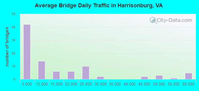
- 1,223,649Total average daily traffic
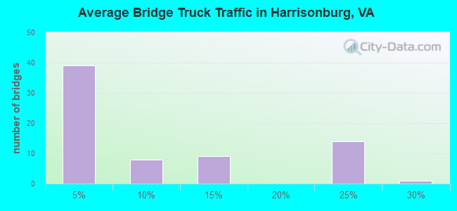
- 177,933Total average daily truck traffic
- National Bridge Inventory (NBI) Registered Bridges for Harrisonburg
- No street view available for this location
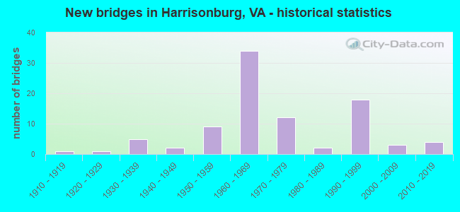
- New bridges - historical statistics
- 11910-1919
- 11920-1929
- 51930-1939
- 21940-1949
- 91950-1959
- 341960-1969
- 121970-1979
- 21980-1989
- 181990-1999
- 32000-2009
- 42010-2019
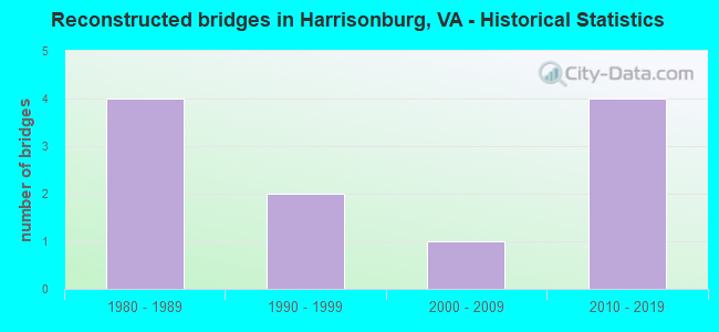
- Reconstructed bridges - Historical Statistics
- 41980-1989
- 21990-1999
- 12000-2009
- 42010-2019
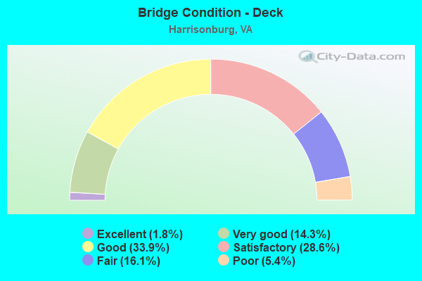
- Bridge Condition - Deck
- 1.8%Excellent
- 14.3%Very good
- 33.9%Good
- 28.6%Satisfactory
- 16.1%Fair
- 5.4%Poor
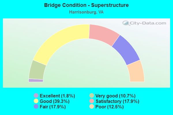
- Bridge Condition - Superstructure
- 1.8%Excellent
- 10.7%Very good
- 39.3%Good
- 17.9%Satisfactory
- 17.9%Fair
- 12.5%Poor
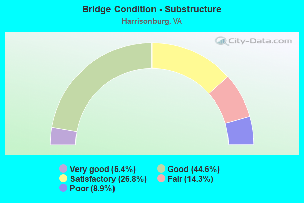
- Bridge Condition - Substructure
- 5.4%Very good
- 44.6%Good
- 26.8%Satisfactory
- 14.3%Fair
- 8.9%Poor
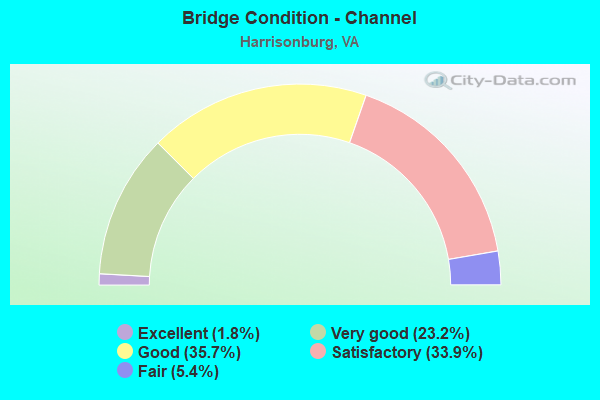
- Bridge Condition - Channel
- 1.8%Excellent
- 23.2%Very good
- 35.7%Good
- 33.9%Satisfactory
- 5.4%Fair
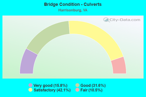
- Bridge Condition - Culverts
- 15.8%Very good
- 31.6%Good
- 42.1%Satisfactory
- 10.5%Fair
Find on map >> Show street view
Structure Number: 20463, Location: 0.24 TO 33 - 3.54 TO 11 (Lat: 38.439636, Lng: -78.848136), Route carried "under" structure: City street , Year Built: 1960, Structure Length: 0. m, Average Daily Traffic: 13,043 (year 2008), Truck Traffic: 3%, Features Intersected: NS RAILWAY & CTY CLUB RD, Facility Carried by Structure: I-81 SBL
Minimum Vertical Clearance: 6.78m (22.24ft), Kilometerpoint: 1.738, Lanes on structure: 3, Lanes under structure: 2, Material/Design: Prestressed concrete, Design/Construction: Stringer/Multi-beam, Length of Maximum Span: 17.6m (57.7ft)
Find on map >> Show street view
Structure Number: 20465, Location: 0.24 TO 33 - 3.54 TO 11 (Lat: 38.439514, Lng: -78.847969), Route carried "under" structure: City street , Year Built: 1960, Structure Length: 0. m, Average Daily Traffic: 13,043 (year 2008), Truck Traffic: 3%, Features Intersected: NS RAILWAY & CTY CLUB RD, Facility Carried by Structure: I-81 NBL
Minimum Vertical Clearance: 7.11m (23.33ft), Kilometerpoint: 1.706, Lanes on structure: 3, Lanes under structure: 2, Material/Design: Prestressed concrete, Design/Construction: Stringer/Multi-beam, Length of Maximum Span: 18.0m (59.1ft)
Find on map >> Show street view
Structure Number: 24556, Location: 0.25 RT 331 - 0.75 RT 331 (Lat: 38.435286, Lng: -78.866236), Route carried "under" structure: Interstate 81, Year Built: 1995, Structure Length: 0. m, Average Daily Traffic: 46,654 (year 2008), Truck Traffic: 13%, Features Intersected: I-81, Facility Carried by Structure: JMU-CARRIER DRIVE
Minimum Vertical Clearance: 6.55m (21.49ft), Kilometerpoint: 397.809, Lanes on structure: 2, Lanes under structure: 4, Material/Design: Steel continuous, Design/Construction: Stringer/Multi-beam, Length of Maximum Span: 48.8m (160.1ft)
Find on map >> Show street view
Structure Number: 26297, Location: 0.02EASTOVER DR-0.35 331 (Lat: 38.435686, Lng: -78.854744), Route carried "under" structure: Interstate 81, Year Built: 1999, Structure Length: 0. m, Average Daily Traffic: 46,654 (year 2008), Truck Traffic: 13%, Features Intersected: I-81, Facility Carried by Structure: RESERVOIR STREET
Minimum Vertical Clearance: 5.79m (19.00ft), Kilometerpoint: 398.775, Lanes on structure: 4, Lanes under structure: 6, Material/Design: Steel continuous, Design/Construction: Stringer/Multi-beam, Length of Maximum Span: 30.0m (98.4ft)
Find on map >> Show street view
Structure Number: 27544, Location: 0.36 RT 839 -.02 RAMBLWD (Lat: 38.418292, Lng: -78.884083), Route carried "under" structure: Interstate 81, Year Built: 2012, Structure Length: 0. m, Average Daily Traffic: 58,000 (year 2019), Truck Traffic: 24%, Features Intersected: I-81, Facility Carried by Structure: STONE SPRING RD
Minimum Vertical Clearance: 7.32m (24.02ft), Kilometerpoint: 392.679, Lanes on structure: 5, Lanes under structure: 4, Material/Design: Steel continuous, Design/Construction: Stringer/Multi-beam, Length of Maximum Span: 52.0m (170.6ft)