Bridge Statistics for Harrisonburg, Virginia (VA)
Condition, Traffic, Stress, Structural Evaluation, Project Costs
- National Bridge Inventory (NBI) Statistics
- 91Number of bridges
- 860ft / 262mTotal length
- $10,568,000Total costs
- 1,223,649Total average daily traffic
- 177,933Total average daily truck traffic
- National Bridge Inventory (NBI) Registered Bridges for Harrisonburg
- No street view available for this location
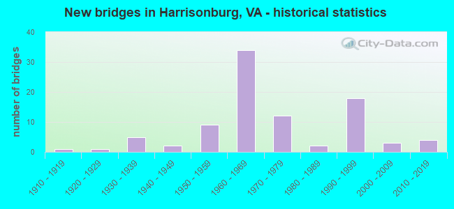
- New bridges - historical statistics
- 11910-1919
- 11920-1929
- 51930-1939
- 21940-1949
- 91950-1959
- 341960-1969
- 121970-1979
- 21980-1989
- 181990-1999
- 32000-2009
- 42010-2019
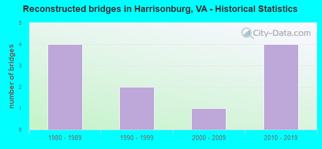
- Reconstructed bridges - Historical Statistics
- 41980-1989
- 21990-1999
- 12000-2009
- 42010-2019
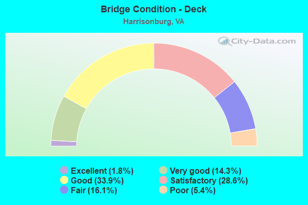
- Bridge Condition - Deck
- 1.8%Excellent
- 14.3%Very good
- 33.9%Good
- 28.6%Satisfactory
- 16.1%Fair
- 5.4%Poor
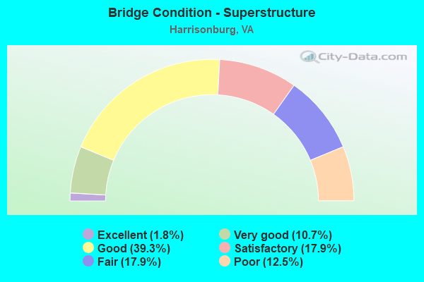
- Bridge Condition - Superstructure
- 1.8%Excellent
- 10.7%Very good
- 39.3%Good
- 17.9%Satisfactory
- 17.9%Fair
- 12.5%Poor
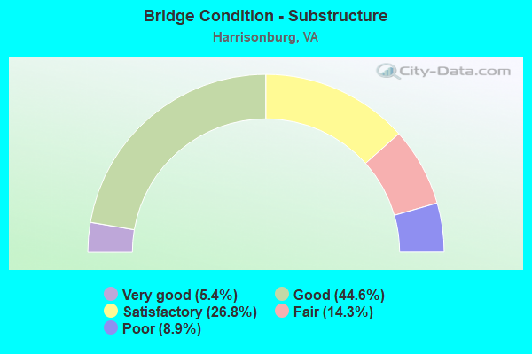
- Bridge Condition - Substructure
- 5.4%Very good
- 44.6%Good
- 26.8%Satisfactory
- 14.3%Fair
- 8.9%Poor
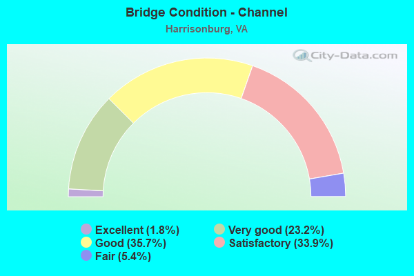
- Bridge Condition - Channel
- 1.8%Excellent
- 23.2%Very good
- 35.7%Good
- 33.9%Satisfactory
- 5.4%Fair
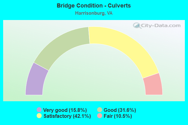
- Bridge Condition - Culverts
- 15.8%Very good
- 31.6%Good
- 42.1%Satisfactory
- 10.5%Fair
Find on map >> Show street view
Structure Number: 20438, Location: 0004BRUCE ST 0008LEWIS ST (Lat: 38.446839, Lng: -78.871331), Route carried "on" structure: US 11, Year Built: 1960, Status: Open, Structure Length: 1.10m (3.61ft), Average Daily Traffic: 2,769 (year 2020), Truck Traffic: 3%, Average Future Daily Traffic: 3,877 (year 2040), Features Intersected: BLACKS RUN, Facility Carried by Structure: SOUTH LIBERTY ST.
Minimum Vertical Clearance: 30+ m (98+ ft), Kilometerpoint: 27.240, Lanes on structure: 2, Owner: City or Municipal Highway Agency, Approaching Roadway Width: 9.1m (29.9ft), Skew: 3 degrees, Material/Design: Concrete, Design/Construction: Culvert, Number Of Spans In Main Unit: 3, Length of Maximum Span: 3.5m (11.5ft), Curb or Sidewalk Widths: Left: 2.4m (7.9ft), Right: 5.5m (18.0ft), Curb-To-Curb Width: 9.1m (29.9ft), Out-to-Out Width: 20.4m (66.9ft)
Condition: Channel: Satisfactory, Culverts: Satisfactory, Operating Rating: 44.5 metric tons, Method Used To Determine Operating Rating: Field evaluation and documented engineering judgment, Inventory Rating: 32.7 metric tons, Method Used To Determine Inventory Rating: Field evaluation and documented engineering judgment, Structural Evaluation: Equal to present minimum criteria, Deck Geometry: Meets minimum limits, Waterway Adequacy: Equal to present desirable criteria, Approach Roadway Alignment: Equal to present minimum criteria, Designated Inspection Frequency: Every 24 months, Inspection Date: November 2021
Find on map >> Show street view
Structure Number: 20439, Location: 0.03MARKET ST0.03WATER ST (Lat: 38.449125, Lng: -78.870758), Route carried "on" structure: US 11, Year Built: 1992, Status: Open, Structure Length: 1.09m (3.58ft), Average Daily Traffic: 2,769 (year 2020), Truck Traffic: 3%, Average Future Daily Traffic: 3,877 (year 2040), Design Load: HS 20+Mod, Features Intersected: BLACKS RUN, Facility Carried by Structure: SOUTH LIBERTY ST
Minimum Vertical Clearance: 30+ m (98+ ft), Kilometerpoint: 26.967, Lanes on structure: 2, Owner: City or Municipal Highway Agency, Approaching Roadway Width: 10.1m (33.1ft), Skew: 1 degrees, Material/Design: Prestressed concrete, Design/Construction: Box Beam or Girders - Multiple, Number Of Spans In Main Unit: 1, Length of Maximum Span: 10.9m (35.8ft), Curb or Sidewalk Widths: Left: 2.1m (6.9ft), Right: 2.7m (8.9ft), Curb-To-Curb Width: 10.1m (33.1ft), Out-to-Out Width: 14.9m (48.9ft)
Condition: Deck: Good, Superstructure: Good, Substructure: Good, Channel: Satisfactory, Operating Rating: 52.6 metric tons, Method Used To Determine Operating Rating: Load and Resistance Factor (LRFR), Inventory Rating: 33.6 metric tons, Method Used To Determine Inventory Rating: Load and Resistance Factor (LRFR), Structural Evaluation: Better than present minimum criteria, Deck Geometry: Somewhat better than minimum adequacy, Waterway Adequacy: Somewhat better than minimum adequacy, Approach Roadway Alignment: Equal to present minimum criteria, Designated Inspection Frequency: Every 24 months, Inspection Date: May 2020, Deck Structure Type: Concrete Cast-file-Place, Wearing Surface/Protective System: Wearing Surface: Epoxy Overlay, Deck Protection: Epoxy Coated Reinforcing
Find on map >> Show street view
Structure Number: 2044, Location: .02ELZBTH ST& .06WOLFE ST (Lat: 38.451031, Lng: -78.870217), Route carried "on" structure: US 11, Year Built: 1932, Year Reconstructed: 1987, Status: Open, Structure Length: 0.84m (2.76ft), Average Daily Traffic: 2,031 (year 2020), Truck Traffic: 3%, Average Future Daily Traffic: 2,843 (year 2040), Design Load: HS 20+Mod, Features Intersected: BLACKS RUN
Minimum Vertical Clearance: 30+ m (98+ ft), Kilometerpoint: 26.790, Lanes on structure: 2, Owner: City or Municipal Highway Agency, Approaching Roadway Width: 11.1m (36.4ft), Skew: 1 degrees, Material/Design: Prestressed concrete, Design/Construction: Box Beam or Girders - Multiple, Number Of Spans In Main Unit: 1, Length of Maximum Span: 8.4m (27.6ft), Curb or Sidewalk Widths: Left: 1.8m (5.9ft), Right: 2.0m (6.6ft), Curb-To-Curb Width: 11.1m (36.4ft), Out-to-Out Width: 14.9m (48.9ft)
Condition: Deck: Good, Superstructure: Good, Substructure: Good, Channel: Good, Operating Rating: 89.8 metric tons, Method Used To Determine Operating Rating: Load and Resistance Factor (LRFR), Inventory Rating: 73.5 metric tons, Method Used To Determine Inventory Rating: Load and Resistance Factor (LRFR), Structural Evaluation: Better than present minimum criteria, Deck Geometry: Equal to present minimum criteria, Waterway Adequacy: Somewhat better than minimum adequacy, Approach Roadway Alignment: Better than present minimum criteria, Designated Inspection Frequency: Every 24 months, Inspection Date: May 2020, Deck Structure Type: Other, Wearing Surface/Protective System: Wearing Surface: Bituminous, Membrane: Epoxy
Find on map >> Show street view
Structure Number: 20441, Location: 0.32 CANTREL -0.25 BURGES (Lat: 38.437981, Lng: -78.851058), Route carried "on" structure: US 33, Year Built: 1960, Status: Open, Structure Length: 7.46m (24.48ft), Average Daily Traffic: 13,340 (year 2020), Truck Traffic: 5%, Average Future Daily Traffic: 18,676 (year 2040), Design Load: HS 20+Mod, Features Intersected: I-81
Minimum Vertical Clearance: 30+ m (98+ ft), Kilometerpoint: 38.294, Lanes on structure: 3, Lanes under structure: 6, Base Highway Network: Yes, Owner: State Highway Agency, Approaching Roadway Width: 11.3m (37.1ft), Material/Design: Prestressed concrete, Design/Construction: Stringer/Multi-beam, Number Of Spans In Main Unit: 4, Length of Maximum Span: 20.9m (68.6ft), Curb or Sidewalk Widths: Left: 0.8m (2.6ft), Right: 0.8m (2.6ft), Curb-To-Curb Width: 11.9m (39.0ft), Out-to-Out Width: 14.0m (45.9ft)
Condition: Deck: Fair, Superstructure: Poor, Substructure: Fair, Operating Rating: 69.9 metric tons, Method Used To Determine Operating Rating: Load Factor (LF), Inventory Rating: 22.7 metric tons, Method Used To Determine Inventory Rating: Load Factor (LF), Structural Evaluation: Meets minimum limits, Deck Geometry: High priority of corrective action, Underclear: High priority of corrective action, Approach Roadway Alignment: Better than present minimum criteria, Length Of Structure Improvement: 7.47m (24.51ft), Designated Inspection Frequency: Every 12 months, Inspection Date: August 2021, Bridge Improvement Cost: $200,000, Roadway Improvement Cost: $75,000, Total Project Cost: $275,000, Deck Structure Type: Concrete Cast-file-Place, Wearing Surface/Protective System: Wearing Surface: Latex Concrete
Find on map >> Show street view
Structure Number: 20443, Location: .32 CANTREL - .83 BURGESS (Lat: 38.437883, Lng: -78.851242), Route carried "on" structure: US 33, Year Built: 1960, Status: Open, Structure Length: 7.46m (24.48ft), Average Daily Traffic: 13,340 (year 2020), Truck Traffic: 5%, Average Future Daily Traffic: 18,676 (year 2040), Design Load: HS 20+Mod, Features Intersected: I-81
Minimum Vertical Clearance: 30+ m (98+ ft), Kilometerpoint: 35.334, Lanes on structure: 3, Lanes under structure: 6, Base Highway Network: Yes, Owner: State Highway Agency, Approaching Roadway Width: 11.3m (37.1ft), Material/Design: Prestressed concrete, Design/Construction: Stringer/Multi-beam, Number Of Spans In Main Unit: 4, Length of Maximum Span: 20.9m (68.6ft), Curb or Sidewalk Widths: Left: 0.8m (2.6ft), Right: 0.8m (2.6ft), Curb-To-Curb Width: 11.9m (39.0ft), Out-to-Out Width: 14.0m (45.9ft)
Condition: Deck: Poor, Superstructure: Poor, Substructure: Poor, Operating Rating: 70.8 metric tons, Method Used To Determine Operating Rating: Load and Resistance Factor (LRFR), Inventory Rating: 42.6 metric tons, Method Used To Determine Inventory Rating: Load and Resistance Factor (LRFR), Structural Evaluation: Meets minimum limits, Deck Geometry: High priority of corrective action, Underclear: High priority of corrective action, Approach Roadway Alignment: Better than present minimum criteria, Length Of Structure Improvement: 7.47m (24.51ft), Designated Inspection Frequency: Every 12 months, Inspection Date: August 2021, Bridge Improvement Cost: $125,000, Roadway Improvement Cost: $45,000, Total Project Cost: $170,000, Deck Structure Type: Concrete Cast-file-Place, Wearing Surface/Protective System: Wearing Surface: Bituminous
Find on map >> Show street view
Structure Number: 20445, Location: .02LIBRTY ST & .04HIGH ST (Lat: 38.449783, Lng: -78.871306), Route carried "on" structure: US 33, Year Built: 1992, Status: Open, Structure Length: 1.09m (3.58ft), Average Daily Traffic: 4,116 (year 2020), Truck Traffic: 4%, Average Future Daily Traffic: 5,762 (year 2040), Design Load: HS 20+Mod, Features Intersected: BLACKS RUN, Facility Carried by Structure: WEST MARKET ST
Minimum Vertical Clearance: 30+ m (98+ ft), Kilometerpoint: 35.269, Lanes on structure: 2, Base Highway Network: Yes, Owner: City or Municipal Highway Agency, Approaching Roadway Width: 11.0m (36.1ft), Skew: 1 degrees, Material/Design: Prestressed concrete, Design/Construction: Box Beam or Girders - Multiple, Number Of Spans In Main Unit: 1, Length of Maximum Span: 10.9m (35.8ft), Curb or Sidewalk Widths: Left: 1.8m (5.9ft), Right: 2.6m (8.5ft), Curb-To-Curb Width: 11.0m (36.1ft), Out-to-Out Width: 15.3m (50.2ft)
Condition: Deck: Good, Superstructure: Good, Substructure: Good, Channel: Satisfactory, Operating Rating: 53.5 metric tons, Method Used To Determine Operating Rating: Load and Resistance Factor (LRFR), Inventory Rating: 33.6 metric tons, Method Used To Determine Inventory Rating: Load and Resistance Factor (LRFR), Structural Evaluation: Better than present minimum criteria, Deck Geometry: Somewhat better than minimum adequacy, Waterway Adequacy: Somewhat better than minimum adequacy, Approach Roadway Alignment: Equal to present minimum criteria, Designated Inspection Frequency: Every 24 months, Inspection Date: May 2020, Deck Structure Type: Concrete Cast-file-Place, Wearing Surface/Protective System: Wearing Surface: Epoxy Overlay, Membrane: Other, Deck Protection: Epoxy Coated Reinforcing
Find on map >> Show street view
Structure Number: 20446, Location: .04 TO CNTRL-.02 TO I-81R (Lat: 38.441178, Lng: -78.853544), Route carried "on" structure: US 33, Year Built: 1960, Status: Open, Structure Length: 5.49m (18.01ft), Average Daily Traffic: 7,915 (year 2020), Truck Traffic: 4%, Average Future Daily Traffic: 10,785 (year 2040), Design Load: HS 20+Mod, Features Intersected: NS RAILWAY & CREEK
Minimum Vertical Clearance: 30+ m (98+ ft), Kilometerpoint: 37.763, Lanes on structure: 2, Base Highway Network: Yes, Owner: State Highway Agency, Approaching Roadway Width: 8.5m (27.9ft), Material/Design: Prestressed concrete, Design/Construction: Stringer/Multi-beam, Number Of Spans In Main Unit: 3, Length of Maximum Span: 22.3m (73.2ft), Curb or Sidewalk Widths: Left: 0.8m (2.6ft), Right: 0.8m (2.6ft), Curb-To-Curb Width: 8.5m (27.9ft), Out-to-Out Width: 10.1m (33.1ft)
Condition: Deck: Fair, Superstructure: Poor, Substructure: Poor, Channel: Good, Operating Rating: 63.5 metric tons, Method Used To Determine Operating Rating: Load and Resistance Factor (LRFR), Inventory Rating: 37.2 metric tons, Method Used To Determine Inventory Rating: Load and Resistance Factor (LRFR), Structural Evaluation: Meets minimum limits, Deck Geometry: High priority of corrective action, Underclear: Better than present minimum criteria, Waterway Adequacy: Equal to present desirable criteria, Approach Roadway Alignment: Equal to present minimum criteria, Length Of Structure Improvement: 5.49m (18.01ft), Designated Inspection Frequency: Every 6 months, Inspection Date: October 2021, Bridge Improvement Cost: $675,000, Roadway Improvement Cost: $50,000, Total Project Cost: $975,000, Deck Structure Type: Concrete Cast-file-Place, Wearing Surface/Protective System: Wearing Surface: Bituminous
Find on map >> Show street view
Structure Number: 20447, Location: 0.04 CNTRL-0.02 I81S RAMP (Lat: 38.441128, Lng: -78.853725), Route carried "on" structure: US 33, Year Built: 1960, Status: Open, Structure Length: 5.49m (18.01ft), Average Daily Traffic: 7,915 (year 2020), Truck Traffic: 4%, Average Future Daily Traffic: 10,785 (year 2040), Design Load: HS 20+Mod, Features Intersected: NS RAILWAY & CREEK
Minimum Vertical Clearance: 30+ m (98+ ft), Kilometerpoint: 37.763, Lanes on structure: 2, Base Highway Network: Yes, Owner: State Highway Agency, Approaching Roadway Width: 8.2m (26.9ft), Material/Design: Prestressed concrete, Design/Construction: Stringer/Multi-beam, Number Of Spans In Main Unit: 3, Length of Maximum Span: 22.1m (72.5ft), Curb or Sidewalk Widths: Left: 0.8m (2.6ft), Right: 0.8m (2.6ft), Curb-To-Curb Width: 8.5m (27.9ft), Out-to-Out Width: 10.1m (33.1ft)
Condition: Deck: Satisfactory, Superstructure: Fair, Substructure: Poor, Channel: Good, Operating Rating: 69.9 metric tons, Method Used To Determine Operating Rating: Load and Resistance Factor (LRFR), Inventory Rating: 43.5 metric tons, Method Used To Determine Inventory Rating: Load and Resistance Factor (LRFR), Structural Evaluation: Meets minimum limits, Deck Geometry: High priority of corrective action, Underclear: Somewhat better than minimum adequacy, Waterway Adequacy: Equal to present desirable criteria, Approach Roadway Alignment: Better than present minimum criteria, Length Of Structure Improvement: 5.49m (18.01ft), Designated Inspection Frequency: Every 6 months, Inspection Date: October 2021, Bridge Improvement Cost: $220,000, Roadway Improvement Cost: $20,000, Total Project Cost: $330,000, Deck Structure Type: Concrete Cast-file-Place, Wearing Surface/Protective System: Wearing Surface: Bituminous, Membrane: Preformed Fabric
Find on map >> Show street view
Structure Number: 20448, Location: 1.17 TO 11 - 1.45 TO 253 (Lat: 38.412681, Lng: -78.891094), Route carried "on" structure: Interstate 81, Year Built: 1959, Status: Open, Structure Length: 4.02m (13.19ft), Average Daily Traffic: 24,411 (year 2020), Truck Traffic: 24%, Average Future Daily Traffic: 34,175 (year 2040), Design Load: HS 20+Mod, Features Intersected: BLACKS RUN
Minimum Vertical Clearance: 30+ m (98+ ft), Kilometerpoint: 394.833, Lanes on structure: 2, Base Highway Network: Yes, Owner: State Highway Agency, Approaching Roadway Width: 12.8m (42.0ft), Material/Design: Prestressed concrete, Design/Construction: Stringer/Multi-beam, Number Of Spans In Main Unit: 3, Length of Maximum Span: 16.2m (53.1ft), Curb-To-Curb Width: 12.8m (42.0ft), Out-to-Out Width: 13.4m (44.0ft)
Condition: Deck: Satisfactory, Superstructure: Fair, Substructure: Fair, Channel: Good, Operating Rating: 73.5 metric tons, Method Used To Determine Operating Rating: Load Factor (LF), Inventory Rating: 41.7 metric tons, Method Used To Determine Inventory Rating: Load Factor (LF), Structural Evaluation: Somewhat better than minimum adequacy, Deck Geometry: Equal to present desirable criteria, Waterway Adequacy: Better than present minimum criteria, Approach Roadway Alignment: Equal to present desirable criteria, Designated Inspection Frequency: Every 24 months, Inspection Date: August 2021, Bridge Improvement Cost: $37,000, Total Project Cost: $40,000, Deck Structure Type: Concrete Cast-file-Place, Wearing Surface/Protective System: Wearing Surface: Latex Concrete
Find on map >> Show street view
Structure Number: 20449, Location: 1.17 TO 11 - 1.45 TO 253 (Lat: 38.412531, Lng: -78.890969), Route carried "on" structure: Interstate 81, Year Built: 1959, Status: Open, Structure Length: 4.02m (13.19ft), Average Daily Traffic: 24,272 (year 2020), Truck Traffic: 24%, Average Future Daily Traffic: 33,981 (year 2040), Design Load: HS 20+Mod, Features Intersected: BLACKS RUN
Minimum Vertical Clearance: 30+ m (98+ ft), Kilometerpoint: 394.366, Lanes on structure: 2, Base Highway Network: Yes, Owner: State Highway Agency, Approaching Roadway Width: 12.8m (42.0ft), Material/Design: Prestressed concrete, Design/Construction: Stringer/Multi-beam, Number Of Spans In Main Unit: 3, Length of Maximum Span: 16.2m (53.1ft), Curb-To-Curb Width: 12.8m (42.0ft), Out-to-Out Width: 13.4m (44.0ft)
Condition: Deck: Satisfactory, Superstructure: Fair, Substructure: Fair, Channel: Good, Operating Rating: 73.5 metric tons, Method Used To Determine Operating Rating: Load and Resistance Factor (LRFR), Inventory Rating: 43.5 metric tons, Method Used To Determine Inventory Rating: Load and Resistance Factor (LRFR), Structural Evaluation: Somewhat better than minimum adequacy, Deck Geometry: Equal to present desirable criteria, Waterway Adequacy: Better than present minimum criteria, Approach Roadway Alignment: Equal to present desirable criteria, Designated Inspection Frequency: Every 24 months, Inspection Date: August 2021, Bridge Improvement Cost: $39,000, Total Project Cost: $41,000, Deck Structure Type: Concrete Cast-file-Place, Wearing Surface/Protective System: Wearing Surface: Latex Concrete
Find on map >> Show street view
Structure Number: 2045, Location: 1.06 RT 11 - 1.55 RT 253 (Lat: 38.411778, Lng: -78.892850), Route carried "on" structure: Interstate 81, Year Built: 1959, Status: Open, Structure Length: 6.15m (20.18ft), Average Daily Traffic: 24,411 (year 2020), Truck Traffic: 24%, Average Future Daily Traffic: 34,175 (year 2040), Design Load: HS 20, Features Intersected: NS RAILWAY
Minimum Vertical Clearance: 30+ m (98+ ft), Kilometerpoint: 394.623, Lanes on structure: 2, Base Highway Network: Yes, Owner: State Highway Agency, Approaching Roadway Width: 12.8m (42.0ft), Skew: 4 degrees, Material/Design: Prestressed concrete, Design/Construction: Stringer/Multi-beam, Number Of Spans In Main Unit: 3, Length of Maximum Span: 20.2m (66.3ft), Curb-To-Curb Width: 12.8m (42.0ft), Out-to-Out Width: 13.4m (44.0ft)
Condition: Deck: Satisfactory, Superstructure: Fair, Substructure: Satisfactory, Operating Rating: 86.2 metric tons, Method Used To Determine Operating Rating: Load and Resistance Factor (LRFR), Inventory Rating: 41.7 metric tons, Method Used To Determine Inventory Rating: Load and Resistance Factor (LRFR), Structural Evaluation: Somewhat better than minimum adequacy, Deck Geometry: Equal to present desirable criteria, Underclear: Meets minimum limits, Approach Roadway Alignment: Equal to present desirable criteria, Designated Inspection Frequency: Every 24 months, Inspection Date: June 2021, Deck Structure Type: Concrete Cast-file-Place, Wearing Surface/Protective System: Wearing Surface: Latex Concrete
Find on map >> Show street view
Structure Number: 20451, Location: 1.06 RT 11 - 1.55 RT 253 (Lat: 38.411539, Lng: -78.892900), Route carried "on" structure: Interstate 81, Year Built: 1959, Status: Open, Structure Length: 6.15m (20.18ft), Average Daily Traffic: 24,272 (year 2020), Truck Traffic: 24%, Average Future Daily Traffic: 33,981 (year 2040), Design Load: HS 20+Mod, Features Intersected: NS RAILWAY
Minimum Vertical Clearance: 30+ m (98+ ft), Kilometerpoint: 394.157, Lanes on structure: 2, Base Highway Network: Yes, Owner: State Highway Agency, Approaching Roadway Width: 12.8m (42.0ft), Skew: 4 degrees, Material/Design: Prestressed concrete, Design/Construction: Stringer/Multi-beam, Number Of Spans In Main Unit: 3, Length of Maximum Span: 20.1m (65.9ft), Curb-To-Curb Width: 12.8m (42.0ft), Out-to-Out Width: 13.4m (44.0ft)
Condition: Deck: Satisfactory, Superstructure: Fair, Substructure: Satisfactory, Operating Rating: 89.8 metric tons, Method Used To Determine Operating Rating: Load and Resistance Factor (LRFR), Inventory Rating: 44.5 metric tons, Method Used To Determine Inventory Rating: Load and Resistance Factor (LRFR), Structural Evaluation: Somewhat better than minimum adequacy, Deck Geometry: Equal to present desirable criteria, Underclear: High priority of corrective action, Approach Roadway Alignment: Equal to present desirable criteria, Designated Inspection Frequency: Every 24 months, Inspection Date: June 2021, Deck Structure Type: Concrete Cast-file-Place, Wearing Surface/Protective System: Wearing Surface: Latex Concrete
Find on map >> Show street view
Structure Number: 20456, Location: 0.44 TO 81- 0.23 TO 11 (Lat: 38.402489, Lng: -78.907628), Route carried "on" structure: Ramp Interstate 81, Year Built: 1966, Status: Open, Structure Length: 9.39m (30.81ft), Average Daily Traffic: 3,412 (year 2020), Average Future Daily Traffic: 4,093 (year 2040), Design Load: HS 20+Mod, Features Intersected: I-81
Minimum Vertical Clearance: 30+ m (98+ ft), Kilometerpoint: 391.888, Lanes on structure: 2, Lanes under structure: 5, Base Highway Network: Yes, Owner: State Highway Agency, Approaching Roadway Width: 17.7m (58.1ft), Skew: 24 degrees, Material/Design: Steel, Design/Construction: Stringer/Multi-beam, Number Of Spans In Main Unit: 4, Length of Maximum Span: 25.0m (82.0ft), Curb or Sidewalk Widths: Left: 0.5m (1.6ft), Right: 0.5m (1.6ft), Curb-To-Curb Width: 12.8m (42.0ft), Out-to-Out Width: 18.6m (61.0ft)
Condition: Deck: Satisfactory, Superstructure: Fair, Substructure: Fair, Operating Rating: 44.5 metric tons, Method Used To Determine Operating Rating: Load and Resistance Factor (LRFR), Inventory Rating: 34.5 metric tons, Method Used To Determine Inventory Rating: Load and Resistance Factor (LRFR), Structural Evaluation: Somewhat better than minimum adequacy, Deck Geometry: Superior to present desirable criteria, Underclear: High priority of corrective action, Approach Roadway Alignment: Better than present minimum criteria, Designated Inspection Frequency: Every 24 months, Inspection Date: August 2021, Bridge Improvement Cost: $112,000, Roadway Improvement Cost: $5,000, Total Project Cost: $117,000, Deck Structure Type: Concrete Cast-file-Place, Wearing Surface/Protective System: Wearing Surface: Epoxy Overlay
Find on map >> Show street view
Structure Number: 20463, Location: 0.24 TO 33 - 3.54 TO 11 (Lat: 38.439636, Lng: -78.848136), Route carried "on" structure: Interstate 81, Year Built: 1960, Status: Open, Structure Length: 6.48m (21.26ft), Average Daily Traffic: 22,128 (year 2020), Truck Traffic: 24%, Average Future Daily Traffic: 30,979 (year 2040), Design Load: HS 20+Mod, Features Intersected: NS RAILWAY & CTY CLUB RD
Minimum Vertical Clearance: 30+ m (98+ ft), Kilometerpoint: 399.933, Lanes on structure: 3, Lanes under structure: 2, Base Highway Network: Yes, Owner: State Highway Agency, Approaching Roadway Width: 14.9m (48.9ft), Material/Design: Prestressed concrete, Design/Construction: Stringer/Multi-beam, Number Of Spans In Main Unit: 4, Length of Maximum Span: 17.6m (57.7ft), Curb-To-Curb Width: 15.5m (50.9ft), Out-to-Out Width: 16.6m (54.5ft)
Condition: Deck: Fair, Superstructure: Satisfactory, Substructure: Satisfactory, Operating Rating: 74.4 metric tons, Method Used To Determine Operating Rating: Load and Resistance Factor (LRFR), Inventory Rating: 48.1 metric tons, Method Used To Determine Inventory Rating: Load and Resistance Factor (LRFR), Structural Evaluation: Equal to present minimum criteria, Deck Geometry: Somewhat better than minimum adequacy, Underclear: Meets minimum limits, Approach Roadway Alignment: Equal to present desirable criteria, Designated Inspection Frequency: Every 24 months, Inspection Date: October 2020, Deck Structure Type: Concrete Cast-file-Place, Wearing Surface/Protective System: Wearing Surface: Bituminous
Find on map >> Show street view
Structure Number: 20465, Location: 0.24 TO 33 - 3.54 TO 11 (Lat: 38.439514, Lng: -78.847969), Route carried "on" structure: Interstate 81, Year Built: 1960, Status: Open, Structure Length: 6.49m (21.29ft), Average Daily Traffic: 22,172 (year 2020), Truck Traffic: 25%, Average Future Daily Traffic: 31,041 (year 2040), Design Load: HS 20+Mod, Features Intersected: NS RAILWAY & CTY CLUB RD
Minimum Vertical Clearance: 30+ m (98+ ft), Kilometerpoint: 399.466, Lanes on structure: 3, Lanes under structure: 2, Base Highway Network: Yes, Owner: State Highway Agency, Approaching Roadway Width: 14.9m (48.9ft), Material/Design: Prestressed concrete, Design/Construction: Stringer/Multi-beam, Number Of Spans In Main Unit: 4, Length of Maximum Span: 18.0m (59.1ft), Curb or Sidewalk Widths: Left: 0.2m (0.7ft), Right: 0.2m (0.7ft), Curb-To-Curb Width: 15.6m (51.2ft), Out-to-Out Width: 16.6m (54.5ft)
Condition: Deck: Fair, Superstructure: Fair, Substructure: Fair, Operating Rating: 72.6 metric tons, Method Used To Determine Operating Rating: Load and Resistance Factor (LRFR), Inventory Rating: 49.0 metric tons, Method Used To Determine Inventory Rating: Load and Resistance Factor (LRFR), Structural Evaluation: Somewhat better than minimum adequacy, Deck Geometry: Somewhat better than minimum adequacy, Underclear: Meets minimum limits, Approach Roadway Alignment: Equal to present desirable criteria, Length Of Structure Improvement: 6.49m (21.29ft), Designated Inspection Frequency: Every 24 months, Inspection Date: October 2021, Bridge Improvement Cost: $200,000, Roadway Improvement Cost: $20,000, Total Project Cost: $250,000, Deck Structure Type: Concrete Cast-file-Place, Wearing Surface/Protective System: Wearing Surface: Latex Concrete
Find on map >> Show street view
Structure Number: 20467, Location: 0.98 RT 11 - 0.06 RT 659 (Lat: 38.431175, Lng: -78.875350), Route carried "on" structure: State highway 331, Year Built: 1972, Year Reconstructed: 2016, Status: Open, Structure Length: 0.73m (2.40ft), Average Daily Traffic: 500 (year 1985), Truck Traffic: 1%, Average Future Daily Traffic: 1,000 (year 2032), Design Load: HS 20+Mod, Features Intersected: TRIB BLACKS RUN
Minimum Vertical Clearance: 30+ m (98+ ft), Kilometerpoint: 3.234, Lanes on structure: 3, Owner: State Highway Agency, Approaching Roadway Width: 12.8m (42.0ft), Skew: 3 degrees, Material/Design: Concrete, Design/Construction: Culvert, Number Of Spans In Main Unit: 2, Length of Maximum Span: 3.7m (12.1ft), Curb or Sidewalk Widths: Left: 0.0m, Right: 2.0m (6.6ft)
Condition: Channel: Very good, Culverts: Good, Operating Rating: 54.5 metric tons, Method Used To Determine Operating Rating: Load Factor (LF), Inventory Rating: 32.7 metric tons, Method Used To Determine Inventory Rating: Load Factor (LF), Structural Evaluation: Better than present minimum criteria, Waterway Adequacy: Equal to present minimum criteria, Approach Roadway Alignment: Equal to present minimum criteria, Designated Inspection Frequency: Every 24 months, Inspection Date: May 2020
Find on map >> Show street view
Structure Number: 20468, Location: 0.56 RT 659 - 0.48 RT 11 (Lat: 38.437097, Lng: -78.870131), Route carried "on" structure: State highway 331, Year Built: 1972, Status: Open, Structure Length: 0.91m (2.99ft), Average Daily Traffic: 500 (year 1985), Truck Traffic: 1%, Average Future Daily Traffic: 1,000 (year 2032), Design Load: HS 20+Mod, Features Intersected: TRIB BLACKS RUN
Minimum Vertical Clearance: 30+ m (98+ ft), Kilometerpoint: 4.039, Lanes on structure: 2, Owner: State Highway Agency, Approaching Roadway Width: 7.9m (25.9ft), Material/Design: Concrete, Design/Construction: Culvert, Number Of Spans In Main Unit: 3, Length of Maximum Span: 3.0m (9.8ft), Curb or Sidewalk Widths: Left: 3.0m (9.8ft), Right: 2.0m (6.6ft), Curb-To-Curb Width: 6.7m (22.0ft), Out-to-Out Width: 15.8m (51.8ft)
Condition: Channel: Very good, Culverts: Good, Operating Rating: 54.5 metric tons, Method Used To Determine Operating Rating: Field evaluation and documented engineering judgment, Inventory Rating: 32.7 metric tons, Method Used To Determine Inventory Rating: Field evaluation and documented engineering judgment, Structural Evaluation: Better than present minimum criteria, Deck Geometry: Meets minimum limits, Waterway Adequacy: Equal to present minimum criteria, Approach Roadway Alignment: Equal to present minimum criteria, Designated Inspection Frequency: Every 24 months, Inspection Date: May 2020
Find on map >> Show street view
Structure Number: 23343, Location: 0.35 RT 780 - 0.15 RT 753 (Lat: 38.540569, Lng: -78.846275), Route carried "on" structure: State highway 42, Year Built: 1991, Status: Open, Structure Length: 5.24m (17.19ft), Average Daily Traffic: 4,955 (year 2020), Truck Traffic: 4%, Average Future Daily Traffic: 6,938 (year 2040), Design Load: HS 20+Mod, Features Intersected: LINVILLE CREEK
Minimum Vertical Clearance: 30+ m (98+ ft), Kilometerpoint: 0.589, Lanes on structure: 2, Base Highway Network: Yes, Owner: State Highway Agency, Approaching Roadway Width: 12.2m (40.0ft), Material/Design: Steel, Design/Construction: Stringer/Multi-beam, Number Of Spans In Main Unit: 3, Length of Maximum Span: 21.3m (69.9ft), Curb-To-Curb Width: 13.0m (42.7ft), Out-to-Out Width: 14.0m (45.9ft)
Condition: Deck: Very good, Superstructure: Good, Substructure: Good, Channel: Very good, Operating Rating: 77.1 metric tons, Method Used To Determine Operating Rating: Load and Resistance Factor (LRFR), Inventory Rating: 59.0 metric tons, Method Used To Determine Inventory Rating: Load and Resistance Factor (LRFR), Structural Evaluation: Better than present minimum criteria, Deck Geometry: Superior to present desirable criteria, Waterway Adequacy: Equal to present minimum criteria, Approach Roadway Alignment: Equal to present desirable criteria, Designated Inspection Frequency: Every 24 months, Inspection Date: December 2021, Deck Structure Type: Concrete Cast-file-Place, Wearing Surface/Protective System: Wearing Surface: Epoxy Overlay, Deck Protection: Epoxy Coated Reinforcing
Find on map >> Show street view
Structure Number: 23344, Location: 0.35 RT 780 - 0.15 RT 753 (Lat: 38.540469, Lng: -78.846086), Route carried "on" structure: State highway 42, Year Built: 1992, Status: Open, Structure Length: 5.24m (17.19ft), Average Daily Traffic: 4,955 (year 2020), Truck Traffic: 4%, Average Future Daily Traffic: 6,938 (year 2040), Design Load: HS 20+Mod, Features Intersected: LINVILLE CREEK
Minimum Vertical Clearance: 30+ m (98+ ft), Kilometerpoint: 377.552, Lanes on structure: 2, Base Highway Network: Yes, Owner: State Highway Agency, Approaching Roadway Width: 12.2m (40.0ft), Material/Design: Steel, Design/Construction: Stringer/Multi-beam, Number Of Spans In Main Unit: 3, Length of Maximum Span: 21.3m (69.9ft), Curb-To-Curb Width: 13.0m (42.7ft), Out-to-Out Width: 14.0m (45.9ft)
Condition: Deck: Very good, Superstructure: Very good, Substructure: Good, Channel: Very good, Operating Rating: 77.1 metric tons, Method Used To Determine Operating Rating: Load and Resistance Factor (LRFR), Inventory Rating: 59.0 metric tons, Method Used To Determine Inventory Rating: Load and Resistance Factor (LRFR), Structural Evaluation: Better than present minimum criteria, Deck Geometry: Superior to present desirable criteria, Waterway Adequacy: Equal to present minimum criteria, Approach Roadway Alignment: Equal to present desirable criteria, Designated Inspection Frequency: Every 24 months, Inspection Date: December 2021, Deck Structure Type: Concrete Cast-file-Place, Wearing Surface/Protective System: Wearing Surface: Epoxy Overlay, Deck Protection: Epoxy Coated Reinforcing
Find on map >> Show street view
Structure Number: 24007, Location: 0.60 RT 42 - 0.70 RT 753 (Lat: 38.522433, Lng: -78.849908), Route carried "on" structure: County highway 721, Year Built: 1994, Status: Open, Structure Length: 0.67m (2.20ft), Average Daily Traffic: 631 (year 2020), Truck Traffic: 5%, Average Future Daily Traffic: 694 (year 2040), Design Load: HS 20+Mod, Features Intersected: TRIB LINVILLE CREEK, Facility Carried by Structure: LINVILLE EDOM RD
Minimum Vertical Clearance: 30+ m (98+ ft), Kilometerpoint: 7.321, Lanes on structure: 2, Owner: State Highway Agency, Approaching Roadway Width: 4.9m (16.1ft), Material/Design: Concrete, Design/Construction: Culvert, Number Of Spans In Main Unit: 2, Length of Maximum Span: 3.0m (9.8ft)
Condition: Channel: Satisfactory, Culverts: Very good, Operating Rating: 52.6 metric tons, Method Used To Determine Operating Rating: Field evaluation and documented engineering judgment, Inventory Rating: 30.8 metric tons, Method Used To Determine Inventory Rating: Field evaluation and documented engineering judgment, Structural Evaluation: Better than present minimum criteria, Waterway Adequacy: Equal to present minimum criteria, Approach Roadway Alignment: Equal to present desirable criteria, Designated Inspection Frequency: Every 24 months, Inspection Date: November 2020
Find on map >> Show street view
Structure Number: 24033, Location: 0004S LIB ST 0004S MAIN S (Lat: 38.447489, Lng: -78.870136), Route carried "on" structure: City street , Year Built: 1994, Status: Open, Structure Length: 1.20m (3.94ft), Average Daily Traffic: 695 (year 2020), Truck Traffic: 2%, Average Future Daily Traffic: 766 (year 2040), Design Load: HS 20+Mod, Features Intersected: BLACKS RUN, Facility Carried by Structure: WEST BRUCE STREET
Minimum Vertical Clearance: 30+ m (98+ ft), Kilometerpoint: 0.000, Lanes on structure: 2, Owner: City or Municipal Highway Agency, Approaching Roadway Width: 5.7m (18.7ft), Skew: 1 degrees, Material/Design: Concrete, Design/Construction: Slab, Number Of Spans In Main Unit: 1, Length of Maximum Span: 12.0m (39.4ft), Curb or Sidewalk Widths: Left: 1.8m (5.9ft), Right: 1.3m (4.3ft), Curb-To-Curb Width: 5.7m (18.7ft), Out-to-Out Width: 9.6m (31.5ft)
Condition: Deck: Good, Superstructure: Good, Substructure: Good, Channel: Satisfactory, Operating Rating: 76.2 metric tons, Method Used To Determine Operating Rating: Load and Resistance Factor (LRFR), Inventory Rating: 59.0 metric tons, Method Used To Determine Inventory Rating: Load and Resistance Factor (LRFR), Structural Evaluation: Better than present minimum criteria, Deck Geometry: High priority of replacement, Waterway Adequacy: Equal to present minimum criteria, Approach Roadway Alignment: Equal to present minimum criteria, Length Of Structure Improvement: 1.19m (3.90ft), Designated Inspection Frequency: Every 24 months, Inspection Date: May 2020, Bridge Improvement Cost: $220,000, Roadway Improvement Cost: $55,000, Total Project Cost: $275,000, Deck Structure Type: Concrete Cast-file-Place, Wearing Surface/Protective System: Wearing Surface: Epoxy Overlay, Deck Protection: Epoxy Coated Reinforcing
Find on map >> Show street view
Structure Number: 24556, Location: 0.25 RT 331 - 0.75 RT 331 (Lat: 38.435286, Lng: -78.866236), Route carried "on" structure: State highway 331, Year Built: 1995, Status: Open, Structure Length: 9.85m (32.32ft), Average Daily Traffic: 400 (year 1998), Average Future Daily Traffic: 1,000 (year 2030), Design Load: HS 20+Mod, Features Intersected: I-81, Facility Carried by Structure: JMU-CARRIER DRIVE
Minimum Vertical Clearance: 30+ m (98+ ft), Kilometerpoint: 4.039, Lanes on structure: 2, Lanes under structure: 4, Owner: State Highway Agency, Approaching Roadway Width: 12.8m (42.0ft), Skew: 4 degrees, Material/Design: Steel continuous, Design/Construction: Stringer/Multi-beam, Number Of Spans In Main Unit: 2, Length of Maximum Span: 48.8m (160.1ft), Curb or Sidewalk Widths: Left: 0.0m, Right: 3.7m (12.1ft), Curb-To-Curb Width: 16.5m (54.1ft), Out-to-Out Width: 17.5m (57.4ft)
Condition: Deck: Very good, Superstructure: Good, Substructure: Very good, Operating Rating: 89.8 metric tons, Method Used To Determine Operating Rating: Load and Resistance Factor (LRFR), Inventory Rating: 75.3 metric tons, Method Used To Determine Inventory Rating: Load and Resistance Factor (LRFR), Structural Evaluation: Better than present minimum criteria, Deck Geometry: Superior to present desirable criteria, Underclear: Better than present minimum criteria, Approach Roadway Alignment: Better than present minimum criteria, Designated Inspection Frequency: Every 24 months, Inspection Date: July 2020, Deck Structure Type: Concrete Cast-file-Place, Wearing Surface/Protective System: Deck Protection: Epoxy Coated Reinforcing
Find on map >> Show street view
Structure Number: 24631, Location: 0.1 MI RTE 42 (Lat: 38.468661, Lng: -78.868383), Route carried "on" structure: County highway 763, Year Built: 1992, Status: Open, Structure Length: 1.06m (3.48ft), Average Daily Traffic: 6,505 (year 2020), Truck Traffic: 6%, Average Future Daily Traffic: 9,107 (year 2040), Features Intersected: TRIB. BLACKS RUN, Facility Carried by Structure: MT. CLINTON PIKE
Minimum Vertical Clearance: 30+ m (98+ ft), Kilometerpoint: 1.223, Lanes on structure: 4, Owner: City or Municipal Highway Agency, Approaching Roadway Width: 14.6m (47.9ft), Skew: 4 degrees, Material/Design: Concrete, Design/Construction: Culvert, Number Of Spans In Main Unit: 3, Length of Maximum Span: 3.0m (9.8ft), Curb-To-Curb Width: 14.6m (47.9ft), Out-to-Out Width: 39.6m (129.9ft)
Condition: Channel: Good, Culverts: Fair, Operating Rating: 44.5 metric tons, Method Used To Determine Operating Rating: Field evaluation and documented engineering judgment, Inventory Rating: 32.7 metric tons, Method Used To Determine Inventory Rating: Field evaluation and documented engineering judgment, Structural Evaluation: Somewhat better than minimum adequacy, Deck Geometry: High priority of replacement, Waterway Adequacy: Equal to present minimum criteria, Approach Roadway Alignment: Equal to present desirable criteria, Designated Inspection Frequency: Every 24 months, Inspection Date: November 2021
Find on map >> Show street view
Structure Number: 24838, Location: 0006N MAIN ST0009JEFF ST (Lat: 38.457017, Lng: -78.863733), Route carried "on" structure: City street , Year Built: 1995, Status: Open, Structure Length: 1.35m (4.43ft), Average Daily Traffic: 3,011 (year 2020), Truck Traffic: 4%, Average Future Daily Traffic: 3,395 (year 2040), Design Load: HS 20+Mod, Features Intersected: BLACKS RUN, Facility Carried by Structure: WEST WASHINGTON ST
Minimum Vertical Clearance: 30+ m (98+ ft), Kilometerpoint: 0.000, Lanes on structure: 2, Owner: City or Municipal Highway Agency, Approaching Roadway Width: 9.1m (29.9ft), Skew: 1 degrees, Material/Design: Concrete continuous, Design/Construction: Frame, Number Of Spans In Main Unit: 2, Length of Maximum Span: 6.8m (22.3ft), Curb or Sidewalk Widths: Left: 1.1m (3.6ft), Right: 1.1m (3.6ft), Curb-To-Curb Width: 9.1m (29.9ft), Out-to-Out Width: 12.2m (40.0ft)
Condition: Deck: Good, Superstructure: Good, Substructure: Good, Channel: Satisfactory, Operating Rating: 89.8 metric tons, Method Used To Determine Operating Rating: Load and Resistance Factor (LRFR), Inventory Rating: 76.2 metric tons, Method Used To Determine Inventory Rating: Load and Resistance Factor (LRFR), Structural Evaluation: Better than present minimum criteria, Deck Geometry: Meets minimum limits, Waterway Adequacy: Equal to present minimum criteria, Approach Roadway Alignment: Somewhat better than minimum adequacy, Designated Inspection Frequency: Every 24 months, Inspection Date: May 2020, Deck Structure Type: Concrete Cast-file-Place, Wearing Surface/Protective System: Wearing Surface: Epoxy Overlay, Deck Protection: Epoxy Coated Reinforcing
Find on map >> Show street view
Structure Number: 25051, Location: 0.01 N LIBRTY-0.03 N MAIN (Lat: 38.453489, Lng: -78.868258), Route carried "on" structure: City street , Year Built: 1997, Status: Open, Structure Length: 1.09m (3.58ft), Average Daily Traffic: 4,610 (year 2020), Truck Traffic: 5%, Average Future Daily Traffic: 5,545 (year 2040), Design Load: HS 20+Mod, Features Intersected: BLACKS RUN, Facility Carried by Structure: WEST GAY STREET
Minimum Vertical Clearance: 30+ m (98+ ft), Kilometerpoint: 0.000, Lanes on structure: 2, Owner: City or Municipal Highway Agency, Approaching Roadway Width: 11.6m (38.1ft), Skew: 3 degrees, Material/Design: Concrete, Design/Construction: Slab, Number Of Spans In Main Unit: 1, Length of Maximum Span: 10.9m (35.8ft), Curb or Sidewalk Widths: Left: 1.2m (3.9ft), Right: 1.2m (3.9ft), Curb-To-Curb Width: 11.6m (38.1ft), Out-to-Out Width: 14.8m (48.6ft)
Condition: Deck: Good, Superstructure: Good, Substructure: Good, Channel: Satisfactory, Operating Rating: 72.6 metric tons, Method Used To Determine Operating Rating: Load and Resistance Factor (LRFR), Inventory Rating: 56.2 metric tons, Method Used To Determine Inventory Rating: Load and Resistance Factor (LRFR), Structural Evaluation: Better than present minimum criteria, Deck Geometry: Somewhat better than minimum adequacy, Waterway Adequacy: Somewhat better than minimum adequacy, Approach Roadway Alignment: Equal to present minimum criteria, Designated Inspection Frequency: Every 24 months, Inspection Date: May 2021, Deck Structure Type: Concrete Cast-file-Place, Wearing Surface/Protective System: Wearing Surface: Epoxy Overlay, Deck Protection: Epoxy Coated Reinforcing
Find on map >> Show street view
Structure Number: 25243, Location: 0020S MAIN ST0002S HIGH S (Lat: 38.443472, Lng: -78.877839), Route carried "on" structure: City street , Year Built: 1997, Status: Open, Structure Length: 1.14m (3.74ft), Average Daily Traffic: 3,886 (year 2020), Truck Traffic: 5%, Average Future Daily Traffic: 4,275 (year 2040), Design Load: HS 20+Mod, Features Intersected: BLACKS RUN, Facility Carried by Structure: WEST GRACE STREET
Minimum Vertical Clearance: 30+ m (98+ ft), Kilometerpoint: 0.000, Lanes on structure: 2, Owner: City or Municipal Highway Agency, Approaching Roadway Width: 9.1m (29.9ft), Material/Design: Concrete, Design/Construction: Slab, Number Of Spans In Main Unit: 1, Length of Maximum Span: 11.4m (37.4ft), Curb or Sidewalk Widths: Left: 1.5m (4.9ft), Right: 1.1m (3.6ft), Curb-To-Curb Width: 9.1m (29.9ft), Out-to-Out Width: 12.6m (41.3ft)
Condition: Deck: Good, Superstructure: Good, Substructure: Good, Channel: Satisfactory, Operating Rating: 73.5 metric tons, Method Used To Determine Operating Rating: Load and Resistance Factor (LRFR), Inventory Rating: 56.2 metric tons, Method Used To Determine Inventory Rating: Load and Resistance Factor (LRFR), Structural Evaluation: Better than present minimum criteria, Deck Geometry: Meets minimum limits, Waterway Adequacy: Equal to present minimum criteria, Approach Roadway Alignment: Equal to present minimum criteria, Designated Inspection Frequency: Every 24 months, Inspection Date: May 2020, Deck Structure Type: Concrete Cast-file-Place, Wearing Surface/Protective System: Wearing Surface: Epoxy Overlay, Deck Protection: Epoxy Coated Reinforcing
Find on map >> Show street view
Structure Number: 26021, Location: 1.60 RT 42 - 0.03 RT 910 (Lat: 38.545881, Lng: -78.871536), Route carried "on" structure: County highway 780, Year Built: 1999, Status: Open, Structure Length: 0.90m (2.95ft), Average Daily Traffic: 32 (year 2018), Average Future Daily Traffic: 36 (year 2040), Design Load: HS 20+Mod, Features Intersected: JOES CREEK, Facility Carried by Structure: SHAVER MILL RD
Minimum Vertical Clearance: 30+ m (98+ ft), Kilometerpoint: 5.549, Lanes on structure: 2, Owner: State Highway Agency, Approaching Roadway Width: 4.6m (15.1ft), Skew: 3 degrees, Material/Design: Concrete, Design/Construction: Culvert, Number Of Spans In Main Unit: 2, Length of Maximum Span: 3.7m (12.1ft)
Condition: Channel: Good, Culverts: Very good, Operating Rating: 44.5 metric tons, Method Used To Determine Operating Rating: Field evaluation and documented engineering judgment, Inventory Rating: 32.7 metric tons, Method Used To Determine Inventory Rating: Field evaluation and documented engineering judgment, Structural Evaluation: Equal to present desirable criteria, Waterway Adequacy: Meets minimum limits, Approach Roadway Alignment: Equal to present desirable criteria, Designated Inspection Frequency: Every 24 months, Inspection Date: September 2021
Find on map >> Show street view
Structure Number: 26294, Location: 0002D MILL CT0015CNTRLL A (Lat: 38.439708, Lng: -78.856286), Route carried "on" structure: County highway 710, Year Built: 1998, Status: Open, Structure Length: 0.80m (2.62ft), Average Daily Traffic: 18,053 (year 2020), Truck Traffic: 1%, Average Future Daily Traffic: 25,274 (year 2040), Features Intersected: SIBERT'S CREEK, Facility Carried by Structure: RESERVIOR STREET
Minimum Vertical Clearance: 30+ m (98+ ft), Kilometerpoint: 0.000, Lanes on structure: 2, Owner: City or Municipal Highway Agency, Approaching Roadway Width: 14.6m (47.9ft), Skew: 2 degrees, Material/Design: Concrete, Design/Construction: Culvert, Number Of Spans In Main Unit: 2, Length of Maximum Span: 3.9m (12.8ft), Curb or Sidewalk Widths: Left: 1.7m (5.6ft), Right: 0.0m, Curb-To-Curb Width: 14.6m (47.9ft), Out-to-Out Width: 23.8m (78.1ft)
Condition: Channel: Good, Culverts: Good, Operating Rating: 44.5 metric tons, Method Used To Determine Operating Rating: Field evaluation and documented engineering judgment, Inventory Rating: 32.7 metric tons, Method Used To Determine Inventory Rating: Field evaluation and documented engineering judgment, Structural Evaluation: Better than present minimum criteria, Deck Geometry: Superior to present desirable criteria, Waterway Adequacy: Equal to present minimum criteria, Approach Roadway Alignment: Equal to present minimum criteria, Designated Inspection Frequency: Every 24 months, Inspection Date: November 2021
Find on map >> Show street view
Structure Number: 26297, Location: 0.02EASTOVER DR-0.35 331 (Lat: 38.435686, Lng: -78.854744), Route carried "on" structure: City street 710, Year Built: 1999, Status: Open, Structure Length: 12.05m (39.53ft), Average Daily Traffic: 18,053 (year 2020), Truck Traffic: 1%, Average Future Daily Traffic: 25,274 (year 2040), Design Load: HS 20+Mod, Features Intersected: I-81, Facility Carried by Structure: RESERVOIR STREET
Minimum Vertical Clearance: 30+ m (98+ ft), Kilometerpoint: 2.446, Lanes on structure: 4, Lanes under structure: 6, Owner: State Highway Agency, Approaching Roadway Width: 13.4m (44.0ft), Skew: 3 degrees, Material/Design: Steel continuous, Design/Construction: Stringer/Multi-beam, Number Of Spans In Main Unit: 4, Length of Maximum Span: 30.0m (98.4ft), Curb or Sidewalk Widths: Left: 1.7m (5.6ft), Right: 1.7m (5.6ft), Curb-To-Curb Width: 14.6m (47.9ft), Out-to-Out Width: 18.6m (61.0ft)
Condition: Deck: Good, Superstructure: Good, Substructure: Good, Operating Rating: 42.6 metric tons, Method Used To Determine Operating Rating: Load and Resistance Factor (LRFR), Inventory Rating: 32.7 metric tons, Method Used To Determine Inventory Rating: Load and Resistance Factor (LRFR), Structural Evaluation: Better than present minimum criteria, Deck Geometry: High priority of replacement, Underclear: Equal to present minimum criteria, Approach Roadway Alignment: Equal to present desirable criteria, Length Of Structure Improvement: 12.04m (39.50ft), Designated Inspection Frequency: Every 24 months, Inspection Date: January 2022, Bridge Improvement Cost: $2,000,000, Roadway Improvement Cost: $1,000,000, Total Project Cost: $3,000,000, Deck Structure Type: Concrete Cast-file-Place, Wearing Surface/Protective System: Deck Protection: Epoxy Coated Reinforcing
Find on map >> Show street view
Structure Number: 27348, Location: 0.30 RT 704E-0.25 RT 704W (Lat: 38.384647, Lng: -78.890256), Route carried "on" structure: County highway 679, Year Built: 2002, Status: Open, Structure Length: 1.74m (5.71ft), Average Daily Traffic: 3,084 (year 2020), Truck Traffic: 4%, Average Future Daily Traffic: 4,318 (year 2040), Design Load: HS 20+Mod, Features Intersected: PLEASANT RUN, Facility Carried by Structure: PLEASANT VALLEY RD
Minimum Vertical Clearance: 30+ m (98+ ft), Kilometerpoint: 1.464, Lanes on structure: 2, Owner: State Highway Agency, Approaching Roadway Width: 7.9m (25.9ft), Skew: 2 degrees, Material/Design: Concrete, Design/Construction: Culvert, Number Of Spans In Main Unit: 4, Length of Maximum Span: 3.7m (12.1ft)
Condition: Channel: Very good, Culverts: Very good, Operating Rating: 44.5 metric tons, Method Used To Determine Operating Rating: Field evaluation and documented engineering judgment, Inventory Rating: 32.7 metric tons, Method Used To Determine Inventory Rating: Field evaluation and documented engineering judgment, Structural Evaluation: Equal to present desirable criteria, Waterway Adequacy: Better than present minimum criteria, Approach Roadway Alignment: Equal to present desirable criteria, Designated Inspection Frequency: Every 24 months, Inspection Date: December 2020
Find on map >> Show street view
Structure Number: 27512, Location: 0.01 E JNSON-0.01 W JNSON (Lat: 38.455847, Lng: -78.864811), Route carried "on" structure: US 11, Year Built: 2002, Status: Open, Structure Length: 1.68m (5.51ft), Average Daily Traffic: 7,329 (year 2020), Truck Traffic: 4%, Average Future Daily Traffic: 9,342 (year 2040), Design Load: HS 20+Mod, Features Intersected: BLACKS RUN, Facility Carried by Structure: N MAIN ST
Minimum Vertical Clearance: 30+ m (98+ ft), Kilometerpoint: 423.650, Lanes on structure: 2, Owner: City or Municipal Highway Agency, Approaching Roadway Width: 11.9m (39.0ft), Skew: 9 degrees, Material/Design: Concrete, Design/Construction: Culvert, Number Of Spans In Main Unit: 3, Length of Maximum Span: 5.1m (16.7ft), Curb-To-Curb Width: 16.1m (52.8ft), Out-to-Out Width: 31.1m (102.0ft)
Condition: Channel: Good, Culverts: Good, Operating Rating: 51.7 metric tons, Method Used To Determine Operating Rating: Load and Resistance Factor (LRFR), Inventory Rating: 39.9 metric tons, Method Used To Determine Inventory Rating: Load and Resistance Factor (LRFR), Structural Evaluation: Better than present minimum criteria, Deck Geometry: Superior to present desirable criteria, Waterway Adequacy: Equal to present minimum criteria, Approach Roadway Alignment: Equal to present desirable criteria, Designated Inspection Frequency: Every 24 months, Inspection Date: May 2021, Wearing Surface/Protective System: Wearing Surface: Epoxy Overlay
Find on map >> Show street view
Structure Number: 27544, Location: 0.36 RT 839 -.02 RAMBLWD (Lat: 38.418292, Lng: -78.884083), Route carried "on" structure: City street 726, Year Built: 2012, Status: Open, Structure Length: 10.39m (34.09ft), Average Daily Traffic: 19,000 (year 2019), Truck Traffic: 3%, Average Future Daily Traffic: 11,251 (year 2035), Design Load: HL 93, Features Intersected: I-81, Facility Carried by Structure: STONE SPRING RD
Minimum Vertical Clearance: 30.18m (99.02ft), Kilometerpoint: 0.000, Lanes on structure: 5, Lanes under structure: 4, Owner: State Highway Agency, Approaching Roadway Width: 18.3m (60.0ft), Skew: 2 degrees, Material/Design: Steel continuous, Design/Construction: Stringer/Multi-beam, Number Of Spans In Main Unit: 2, Length of Maximum Span: 52.0m (170.6ft), Curb or Sidewalk Widths: Left: 1.7m (5.6ft), Right: 1.7m (5.6ft), Curb-To-Curb Width: 22.6m (74.1ft), Out-to-Out Width: 26.4m (86.6ft)
Condition: Deck: Good, Superstructure: Very good, Substructure: Good, Operating Rating: 55.3 metric tons, Method Used To Determine Operating Rating: Load and Resistance Factor (LRFR), Inventory Rating: 42.6 metric tons, Method Used To Determine Inventory Rating: Load and Resistance Factor (LRFR), Structural Evaluation: Better than present minimum criteria, Deck Geometry: Equal to present minimum criteria, Underclear: Equal to present minimum criteria, Approach Roadway Alignment: Better than present minimum criteria, Designated Inspection Frequency: Every 24 months, Inspection Date: June 2020, Bridge Improvement Cost: $50,000, Roadway Improvement Cost: $5,000, Total Project Cost: $60,000, Deck Structure Type: Concrete Cast-file-Place, Wearing Surface/Protective System: Deck Protection: Other
Find on map >> Show street view
Structure Number: 29038, Location: 0.05 RT 721 - 0.11 RT 859 (Lat: 38.525128, Lng: -78.861383), Route carried "on" structure: State highway 42, Year Built: 1988, Status: Open, Structure Length: 1.77m (5.81ft), Average Daily Traffic: 9,911 (year 2020), Truck Traffic: 4%, Average Future Daily Traffic: 11,652 (year 2040), Design Load: HS 20+Mod, Features Intersected: WEST FORK LINVILLE CREEK
Minimum Vertical Clearance: 30+ m (98+ ft), Kilometerpoint: 375.557, Lanes on structure: 4, Base Highway Network: Yes, Owner: State Highway Agency, Approaching Roadway Width: 24.4m (80.1ft), Material/Design: Concrete, Design/Construction: Culvert, Number Of Spans In Main Unit: 4, Length of Maximum Span: 4.3m (14.1ft)
Condition: Channel: Good, Culverts: Satisfactory, Operating Rating: 44.5 metric tons, Method Used To Determine Operating Rating: Field evaluation and documented engineering judgment, Inventory Rating: 32.7 metric tons, Method Used To Determine Inventory Rating: Field evaluation and documented engineering judgment, Structural Evaluation: Equal to present minimum criteria, Waterway Adequacy: Equal to present desirable criteria, Approach Roadway Alignment: Equal to present desirable criteria, Designated Inspection Frequency: Every 24 months, Inspection Date: Febuary 2021
Find on map >> Show street view
Structure Number: 30104, Location: 0.60 RTE 11 (Lat: 38.421400, Lng: -78.890200), Route carried "on" structure: City street 280, Year Built: 2012, Status: Open, Structure Length: 6.18m (20.28ft), Average Daily Traffic: 19,000 (year 2019), Truck Traffic: 3%, Average Future Daily Traffic: 14,400 (year 2032), Design Load: HS 20+Mod, Features Intersected: BLACKS RUN & NS RR, Facility Carried by Structure: STONE SPRING ROAD
Minimum Vertical Clearance: 30+ m (98+ ft), Kilometerpoint: 0.000, Lanes on structure: 4, Owner: City or Municipal Highway Agency, Approaching Roadway Width: 18.9m (62.0ft), Skew: 20 degrees, Material/Design: Steel continuous, Design/Construction: Stringer/Multi-beam, Number Of Spans In Main Unit: 2, Number Of Approach Spans: 2, Length of Maximum Span: 30.9m (101.4ft), Curb or Sidewalk Widths: Left: 1.7m (5.6ft), Right: 1.7m (5.6ft), Curb-To-Curb Width: 23.8m (78.1ft), Out-to-Out Width: 27.6m (90.6ft)
Condition: Deck: Good, Superstructure: Good, Substructure: Good, Channel: Very good, Operating Rating: 39.0 metric tons, Method Used To Determine Operating Rating: Load and Resistance Factor (LRFR), Inventory Rating: 29.9 metric tons, Method Used To Determine Inventory Rating: Load and Resistance Factor (LRFR), Structural Evaluation: Better than present minimum criteria, Deck Geometry: Superior to present desirable criteria, Underclear: Superior to present desirable criteria, Waterway Adequacy: Superior to present desirable criteria, Approach Roadway Alignment: Equal to present desirable criteria, Designated Inspection Frequency: Every 24 months, Inspection Date: May 2020, Deck Structure Type: Concrete Cast-file-Place, Wearing Surface/Protective System: Deck Protection: Other
Find on map >> Show street view
Structure Number: 31127, Location: 0.48 RT 11 0.87 SCL HARR (Lat: 38.402258, Lng: -78.900397), Route carried "on" structure: City street , Year Built: 2018, Status: Open, Structure Length: 2.28m (7.48ft), Average Daily Traffic: 8,200 (year 2018), Truck Traffic: 14%, Average Future Daily Traffic: 8,298 (year 2035), Design Load: HL 93, Features Intersected: BLACKS RUN, Facility Carried by Structure: PLEASANT VALLEY RD
Minimum Vertical Clearance: 30+ m (98+ ft), Kilometerpoint: 1.400, Lanes on structure: 2, Owner: City or Municipal Highway Agency, Approaching Roadway Width: 11.0m (36.1ft), Material/Design: Steel, Design/Construction: Stringer/Multi-beam, Number Of Spans In Main Unit: 1, Length of Maximum Span: 22.8m (74.8ft), Curb or Sidewalk Widths: Left: 2.0m (6.6ft), Right: 2.0m (6.6ft), Curb-To-Curb Width: 11.0m (36.1ft), Out-to-Out Width: 15.5m (50.9ft)
Condition: Deck: Excellent, Superstructure: Excellent, Substructure: Good, Channel: Excellent, Operating Rating: 58.1 metric tons, Method Used To Determine Operating Rating: Load and Resistance Factor (LRFR), Inventory Rating: 45.4 metric tons, Method Used To Determine Inventory Rating: Load and Resistance Factor (LRFR), Structural Evaluation: Better than present minimum criteria, Deck Geometry: Meets minimum limits, Waterway Adequacy: Better than present minimum criteria, Approach Roadway Alignment: Equal to present minimum criteria, Length Of Structure Improvement: 2.28m (7.48ft), Designated Inspection Frequency: Every 24 months, Inspection Date: May 2020, Deck Structure Type: Concrete Cast-file-Place, Wearing Surface/Protective System: Wearing Surface: Monolithic Concrete, Deck Protection: Other
Find on map >> Show street view
Structure Number: 15819, Location: 0.33 RT 11 - 0.42 81 NBL (Lat: 38.481428, Lng: -78.811178), Route carried "under" structure: Interstate 81, Year Built: 1965, Structure Length: 0. m, Average Daily Traffic: 21,387 (year 2008), Truck Traffic: 12%, Features Intersected: I-81
Minimum Vertical Clearance: 6.29m (20.64ft), Kilometerpoint: 405.677, Lanes on structure: 1, Lanes under structure: 5, Material/Design: Steel, Design/Construction: Stringer/Multi-beam, Length of Maximum Span: 21.6m (70.9ft)
Find on map >> Show street view
Structure Number: 15821, Location: 0.33 RT 11 - 0.42 81 NBL (Lat: 38.481611, Lng: -78.810092), Route carried "under" structure: Interstate 81, Year Built: 1965, Structure Length: 0. m, Average Daily Traffic: 21,387 (year 2008), Truck Traffic: 12%, Features Intersected: I-81
Minimum Vertical Clearance: 6.41m (21.03ft), Kilometerpoint: 405.693, Lanes on structure: 1, Lanes under structure: 5, Material/Design: Steel, Design/Construction: Stringer/Multi-beam, Length of Maximum Span: 21.9m (71.9ft)
Find on map >> Show street view
Structure Number: 16047, Location: 0.46 RT 988 - 0.60 RT 11 (Lat: 38.377142, Lng: -78.918856), Route carried "under" structure: Interstate 81, Year Built: 1966, Structure Length: 0. m, Average Daily Traffic: 45,881 (year 2008), Truck Traffic: 12%, Features Intersected: I-81, Facility Carried by Structure: CECIL WAMPLER RD
Minimum Vertical Clearance: 5.08m (16.67ft), Kilometerpoint: 389.555, Lanes on structure: 2, Lanes under structure: 4, Material/Design: Prestressed concrete, Design/Construction: Stringer/Multi-beam, Length of Maximum Span: 20.7m (67.9ft)
Find on map >> Show street view
Structure Number: 1607, Location: 0.24 RT 11 - 0.02 RT F238 (Lat: 38.494806, Lng: -78.800467), Route carried "under" structure: Interstate 81, Year Built: 1965, Structure Length: 0. m, Average Daily Traffic: 42,775 (year 2008), Truck Traffic: 12%, Features Intersected: I-81, Facility Carried by Structure: TRINITY CHURCH RD
Minimum Vertical Clearance: 5.67m (18.60ft), Kilometerpoint: 406.948, Lanes on structure: 2, Lanes under structure: 4, Material/Design: Prestressed concrete, Design/Construction: Stringer/Multi-beam, Length of Maximum Span: 19.9m (65.3ft)
Find on map >> Show street view
Structure Number: 20402, Location: 0.18 RTE 11-0.05 RTE 973 (Lat: 38.404178, Lng: -78.904925), Route carried "under" structure: Interstate 81, Year Built: 1959, Structure Length: 0. m, Average Daily Traffic: 56,000 (year 2018), Truck Traffic: 24%, Features Intersected: I-81, Facility Carried by Structure: PLEASANT VALLEY RD
Minimum Vertical Clearance: 5.02m (16.47ft), Kilometerpoint: 396.715, Lanes on structure: 2, Lanes under structure: 5, Material/Design: Prestressed concrete, Design/Construction: Box Beam or Girders - Multiple, Length of Maximum Span: 18.3m (60.0ft)
Find on map >> Show street view
Structure Number: 20406, Location: 0.50 RT11-0.12FOREST HILL (Lat: 38.429711, Lng: -78.875600), Route carried "under" structure: Interstate 81, Year Built: 1960, Structure Length: 0. m, Average Daily Traffic: 29,110 (year 1994), Features Intersected: I-81, Facility Carried by Structure: PORT REPUBLIC ROAD
Minimum Vertical Clearance: 5.31m (17.42ft), Kilometerpoint: 0.000, Lanes on structure: 5, Lanes under structure: 4, Material/Design: Steel continuous, Design/Construction: Stringer/Multi-beam, Length of Maximum Span: 23.8m (78.1ft)
Find on map >> Show street view
Structure Number: 20408, Location: 0.11 RT 720N-0.01 RT F238 (Lat: 38.453275, Lng: -78.834739), Route carried "under" structure: Interstate 81, Year Built: 1960, Structure Length: 0. m, Average Daily Traffic: 52,000 (year 2018), Truck Traffic: 24%, Features Intersected: I-81, Facility Carried by Structure: Old Furnace Road
Minimum Vertical Clearance: 4.82m (15.81ft), Kilometerpoint: 400.319, Lanes on structure: 2, Lanes under structure: 4, Material/Design: Prestressed concrete, Design/Construction: Stringer/Multi-beam, Length of Maximum Span: 24.1m (79.1ft)
Find on map >> Show street view
Structure Number: 20414, Location: 0004S HIGH ST0008S MAIN S (Lat: 38.444006, Lng: -78.875461), Route carried "under" structure: City street , Year Built: 1972, Structure Length: 0. m, Average Daily Traffic: 1,000 (year 1994), Features Intersected: BLKS RN/NS RR/CHS'PK DR, Facility Carried by Structure: MLK Jr Way
Minimum Vertical Clearance: 7.26m (23.82ft), Kilometerpoint: 0.000, Lanes on structure: 4, Lanes under structure: 2, Material/Design: Steel, Design/Construction: Stringer/Multi-beam, Length of Maximum Span: 29.0m (95.1ft)
Find on map >> Show street view
Structure Number: 20441, Location: 0.32 CANTREL -0.25 BURGES (Lat: 38.437981, Lng: -78.851058), Route carried "under" structure: Interstate 81, Year Built: 1960, Structure Length: 0. m, Average Daily Traffic: 57,000 (year 2018), Truck Traffic: 24%, Features Intersected: I-81, Facility Carried by Structure: ROUTE 33 WBL
Minimum Vertical Clearance: 5.11m (16.77ft), Kilometerpoint: 399.145, Lanes on structure: 3, Lanes under structure: 6, Material/Design: Prestressed concrete, Design/Construction: Stringer/Multi-beam, Length of Maximum Span: 20.9m (68.6ft)
Find on map >> Show street view
Structure Number: 20443, Location: .32 CANTREL - .83 BURGESS (Lat: 38.437883, Lng: -78.851242), Route carried "under" structure: Interstate 81, Year Built: 1960, Structure Length: 0. m, Average Daily Traffic: 57,000 (year 2018), Truck Traffic: 24%, Features Intersected: I-81, Facility Carried by Structure: ROUTE 33 EBL
Minimum Vertical Clearance: 5.66m (18.57ft), Kilometerpoint: 399.112, Lanes on structure: 3, Lanes under structure: 6, Material/Design: Prestressed concrete, Design/Construction: Stringer/Multi-beam, Length of Maximum Span: 20.9m (68.6ft)
Find on map >> Show street view
Structure Number: 20456, Location: 0.44 TO 81- 0.23 TO 11 (Lat: 38.402489, Lng: -78.907628), Route carried "under" structure: Interstate 81, Year Built: 1966, Structure Length: 0. m, Average Daily Traffic: 56,000 (year 2018), Truck Traffic: 24%, Features Intersected: I-81
Minimum Vertical Clearance: 5.13m (16.83ft), Kilometerpoint: 392.499, Lanes on structure: 2, Lanes under structure: 5, Material/Design: Steel, Design/Construction: Stringer/Multi-beam, Length of Maximum Span: 25.0m (82.0ft)