Bridge Statistics for Independence, Missouri (MO)
Condition, Traffic, Stress, Structural Evaluation, Project Costs
- National Bridge Inventory (NBI) Statistics
- 192Number of bridges
- 2,431ft / 741mTotal length
- $14,570,000Total costs
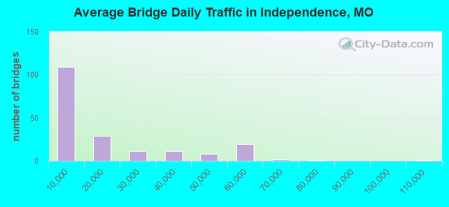
- 3,066,024Total average daily traffic
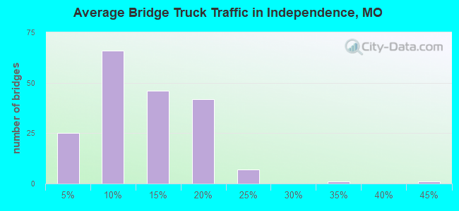
- 408,541Total average daily truck traffic
- National Bridge Inventory (NBI) Registered Bridges for Independence
- No street view available for this location
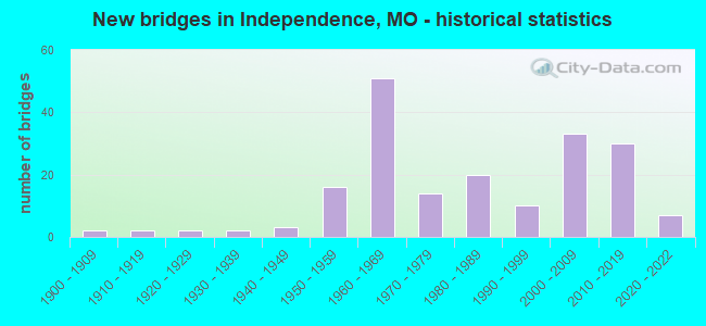
- New bridges - historical statistics
- 21900-1909
- 21910-1919
- 21920-1929
- 21930-1939
- 31940-1949
- 161950-1959
- 511960-1969
- 141970-1979
- 201980-1989
- 101990-1999
- 332000-2009
- 302010-2019
- 72020-2022
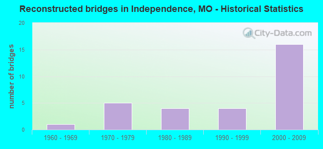
- Reconstructed bridges - Historical Statistics
- 11960-1969
- 51970-1979
- 41980-1989
- 41990-1999
- 162000-2009
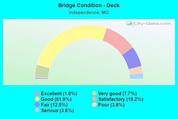
- Bridge Condition - Deck
- 1.0%Excellent
- 7.7%Very good
- 51.9%Good
- 19.2%Satisfactory
- 12.5%Fair
- 3.8%Poor
- 3.8%Serious
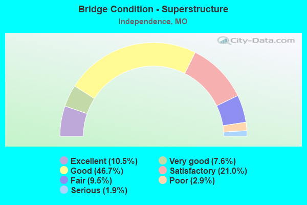
- Bridge Condition - Superstructure
- 10.5%Excellent
- 7.6%Very good
- 46.7%Good
- 21.0%Satisfactory
- 9.5%Fair
- 2.9%Poor
- 1.9%Serious
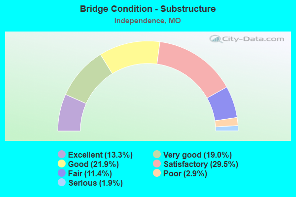
- Bridge Condition - Substructure
- 13.3%Excellent
- 19.0%Very good
- 21.9%Good
- 29.5%Satisfactory
- 11.4%Fair
- 2.9%Poor
- 1.9%Serious
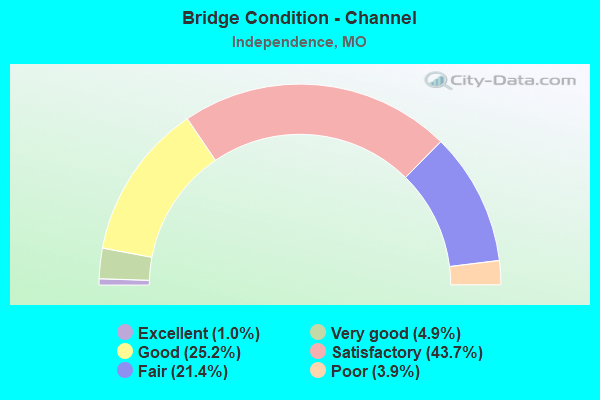
- Bridge Condition - Channel
- 1.0%Excellent
- 4.9%Very good
- 25.2%Good
- 43.7%Satisfactory
- 21.4%Fair
- 3.9%Poor
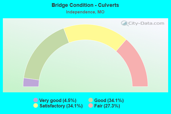
- Bridge Condition - Culverts
- 4.5%Very good
- 34.1%Good
- 34.1%Satisfactory
- 27.3%Fair
Find on map >> Show street view
Structure Number: 33193, Location: S 32 T 50 N R 32 W (Lat: 39.104258, Lng: -94.470183), Route carried "on" structure: US 24, Year Built: 2010, Status: Open, Structure Length: 3.70m (12.14ft), Average Daily Traffic: 17,445 (year 2021), Truck Traffic: 8%, Average Future Daily Traffic: 23,551 (year 2041), Design Load: HS 20, Features Intersected: ROCK CR
Minimum Vertical Clearance: 30+ m (98+ ft), Kilometerpoint: 20.987, Lanes on structure: 5, Base Highway Network: Yes, Owner: State Highway Agency, Approaching Roadway Width: 24.4m (80.1ft), Material/Design: Prestressed concrete, Design/Construction: Box Beam or Girders - Multiple, Number Of Spans In Main Unit: 1, Length of Maximum Span: 36.6m (120.1ft), Curb-To-Curb Width: 24.4m (80.1ft), Out-to-Out Width: 25.0m (82.0ft)
Condition: Deck: Satisfactory, Superstructure: Satisfactory, Substructure: Good, Channel: Satisfactory, Operating Rating: 95.4 metric tons, Method Used To Determine Operating Rating: Load Factor (LF), Inventory Rating: 38.7 metric tons, Method Used To Determine Inventory Rating: Load Factor (LF), Structural Evaluation: Equal to present minimum criteria, Deck Geometry: Superior to present desirable criteria, Waterway Adequacy: Superior to present desirable criteria, Approach Roadway Alignment: Equal to present desirable criteria, Designated Inspection Frequency: Every 24 months, Inspection Date: September 2021, Deck Structure Type: Concrete Cast-file-Place, Wearing Surface/Protective System: Wearing Surface: Monolithic Concrete, Deck Protection: Epoxy Coated Reinforcing
Find on map >> Show street view
Structure Number: 33543, Location: S 5 T 49 N R 31 W (Lat: 39.092989, Lng: -94.366411), Route carried "on" structure: City street 150, Year Built: 2011, Status: Open, Structure Length: 0.61m (2.00ft), Average Daily Traffic: 4,000 (year 2021), Truck Traffic: 10%, Average Future Daily Traffic: 5,200 (year 2041), Features Intersected: TRIB TO SPRING BR, Facility Carried by Structure: TRUMAN RD
Minimum Vertical Clearance: 30+ m (98+ ft), Kilometerpoint: 0.000, Lanes on structure: 3, Owner: City or Municipal Highway Agency, Approaching Roadway Width: 15.2m (49.9ft), Material/Design: Concrete, Design/Construction: Culvert, Number Of Spans In Main Unit: 2, Length of Maximum Span: 3.0m (9.8ft)
Condition: Channel: Good, Culverts: Good, Operating Rating: 54.0 metric tons, Method Used To Determine Operating Rating: Load Factor (LF), Inventory Rating: 32.4 metric tons, Method Used To Determine Inventory Rating: Load Factor (LF), Structural Evaluation: Better than present minimum criteria, Waterway Adequacy: Superior to present desirable criteria, Approach Roadway Alignment: Equal to present desirable criteria, Designated Inspection Frequency: Every 24 months, Inspection Date: January 2021
Find on map >> Show street view
Structure Number: 33544, Location: S 17 T 49 N R 30 W (Lat: 39.061167, Lng: -94.346272), Route carried "on" structure: City street , Year Built: 2010, Status: Open, Structure Length: 0.91m (2.99ft), Average Daily Traffic: 1,000 (year 2021), Truck Traffic: 10%, Average Future Daily Traffic: 1,300 (year 2041), Features Intersected: BR OF CRACKERNAK C, Facility Carried by Structure: S JACKSON DR
Minimum Vertical Clearance: 30+ m (98+ ft), Kilometerpoint: 0.000, Lanes on structure: 4, Owner: City or Municipal Highway Agency, Approaching Roadway Width: 15.8m (51.8ft), Skew: 1 degrees, Material/Design: Concrete, Design/Construction: Culvert, Number Of Spans In Main Unit: 3, Length of Maximum Span: 2.7m (8.9ft)
Condition: Channel: Satisfactory, Culverts: Good, Operating Rating: 54.0 metric tons, Method Used To Determine Operating Rating: Load Factor (LF), Inventory Rating: 32.4 metric tons, Method Used To Determine Inventory Rating: Load Factor (LF), Structural Evaluation: Better than present minimum criteria, Waterway Adequacy: Equal to present minimum criteria, Approach Roadway Alignment: Equal to present desirable criteria, Designated Inspection Frequency: Every 24 months, Inspection Date: January 2021
Find on map >> Show street view
Structure Number: 34272, Location: S 34 T 50 N R 31 W (Lat: 39.106528, Lng: -94.309639), Route carried "on" structure: City street , Year Built: 2013, Status: Open, Structure Length: 4.33m (14.21ft), Average Daily Traffic: 571 (year 2021), Truck Traffic: 2%, Average Future Daily Traffic: 742 (year 2041), Design Load: HS 20, Features Intersected: BR OF LIT BLUE RVR, Facility Carried by Structure: BLY RD
Minimum Vertical Clearance: 30+ m (98+ ft), Kilometerpoint: 1.609, Lanes on structure: 2, Owner: City or Municipal Highway Agency, Approaching Roadway Width: 7.3m (24.0ft), Skew: 4 degrees, Material/Design: Prestressed concrete, Design/Construction: Tee Beam, Number Of Spans In Main Unit: 1, Length of Maximum Span: 41.5m (136.2ft), Curb-To-Curb Width: 10.7m (35.1ft), Out-to-Out Width: 15.4m (50.5ft)
Condition: Deck: Good, Superstructure: Good, Substructure: Excellent, Channel: Good, Inventory Rating: 54.9 metric tons, Method Used To Determine Inventory Rating: Load Factor (LF), Structural Evaluation: Better than present minimum criteria, Deck Geometry: Equal to present minimum criteria, Waterway Adequacy: Superior to present desirable criteria, Approach Roadway Alignment: Equal to present desirable criteria, Designated Inspection Frequency: Every 24 months, Inspection Date: January 2021, Deck Structure Type: Concrete Cast-file-Place, Wearing Surface/Protective System: Wearing Surface: Monolithic Concrete, Deck Protection: Epoxy Coated Reinforcing
Find on map >> Show street view
Structure Number: 3434, Location: S 20 T 49 N R 31 W (Lat: 39.054003, Lng: -94.366453), Route carried "on" structure: State highway 291, Year Built: 1983, Status: Open, Structure Length: 4.79m (15.72ft), Average Daily Traffic: 26,180 (year 2021), Truck Traffic: 10%, Average Future Daily Traffic: 35,343 (year 2041), Design Load: HS 20, Features Intersected: KCS RR
Minimum Vertical Clearance: 30+ m (98+ ft), Kilometerpoint: 45.511, Lanes on structure: 2, Base Highway Network: Yes, Owner: State Highway Agency, Approaching Roadway Width: 12.2m (40.0ft), Skew: 1 degrees, Material/Design: Prestressed concrete continuous, Design/Construction: Stringer/Multi-beam, Number Of Spans In Main Unit: 3, Length of Maximum Span: 16.0m (52.5ft), Curb or Sidewalk Widths: Left: 0.2m (0.7ft), Right: 0.2m (0.7ft), Curb-To-Curb Width: 11.8m (38.7ft), Out-to-Out Width: 12.6m (41.3ft)
Condition: Deck: Good, Superstructure: Good, Substructure: Good, Operating Rating: 80.1 metric tons, Method Used To Determine Operating Rating: Load Factor (LF), Inventory Rating: 43.2 metric tons, Method Used To Determine Inventory Rating: Load Factor (LF), Structural Evaluation: Better than present minimum criteria, Deck Geometry: Equal to present minimum criteria, Underclear: Equal to present minimum criteria, Approach Roadway Alignment: Equal to present desirable criteria, Designated Inspection Frequency: Every 24 months, Inspection Date: October 2021, Deck Structure Type: Concrete Cast-file-Place, Wearing Surface/Protective System: Wearing Surface: Monolithic Concrete, Deck Protection: Epoxy Coated Reinforcing
Find on map >> Show street view
Structure Number: 34361, Location: S 21 T 49 N R 31 W (Lat: 39.047358, Lng: -94.337233), Route carried "on" structure: City street 39, Year Built: 2013, Status: Open, Structure Length: 7.34m (24.08ft), Average Daily Traffic: 8,710 (year 2021), Truck Traffic: 10%, Average Future Daily Traffic: 11,323 (year 2041), Design Load: HS 20, Features Intersected: LIT BLUE RVR
Minimum Vertical Clearance: 30+ m (98+ ft), Kilometerpoint: 0.161, Lanes on structure: 4, Owner: City or Municipal Highway Agency, Approaching Roadway Width: 16.3m (53.5ft), Skew: 20 degrees, Material/Design: Prestressed concrete continuous, Design/Construction: Stringer/Multi-beam, Number Of Spans In Main Unit: 3, Length of Maximum Span: 24.5m (80.4ft), Curb or Sidewalk Widths: Left: 1.5m (4.9ft), Right: 2.4m (7.9ft), Curb-To-Curb Width: 16.3m (53.5ft), Out-to-Out Width: 26.9m (88.3ft)
Condition: Deck: Good, Superstructure: Good, Substructure: Excellent, Channel: Good, Operating Rating: 68.4 metric tons, Method Used To Determine Operating Rating: Load Factor (LF), Inventory Rating: 36.0 metric tons, Method Used To Determine Inventory Rating: Load Factor (LF), Structural Evaluation: Better than present minimum criteria, Deck Geometry: Meets minimum limits, Waterway Adequacy: Superior to present desirable criteria, Approach Roadway Alignment: Equal to present desirable criteria, Designated Inspection Frequency: Every 24 months, Inspection Date: January 2021, Deck Structure Type: Concrete Cast-file-Place, Wearing Surface/Protective System: Wearing Surface: Integral Concrete, Deck Protection: Epoxy Coated Reinforcing
Find on map >> Show street view
Structure Number: 34494, Location: S 34 T 50 N R 31 W (Lat: 39.104719, Lng: -94.316469), Route carried "on" structure: City street , Year Built: 2012, Status: Open, Structure Length: 4.33m (14.21ft), Average Daily Traffic: 2,000 (year 2021), Truck Traffic: 5%, Average Future Daily Traffic: 2,600 (year 2041), Features Intersected: BUNDSHU CR, Facility Carried by Structure: LIT BLUE PARKWY NB
Minimum Vertical Clearance: 30+ m (98+ ft), Kilometerpoint: 0.000, Lanes on structure: 2, Owner: City or Municipal Highway Agency, Approaching Roadway Width: 11.0m (36.1ft), Material/Design: Prestressed concrete continuous, Design/Construction: Tee Beam, Number Of Spans In Main Unit: 2, Length of Maximum Span: 20.1m (65.9ft), Curb or Sidewalk Widths: Left: 0.0m, Right: 2.6m (8.5ft), Curb-To-Curb Width: 11.0m (36.1ft), Out-to-Out Width: 14.3m (46.9ft)
Condition: Deck: Good, Superstructure: Good, Substructure: Excellent, Channel: Satisfactory, Operating Rating: 55.8 metric tons, Method Used To Determine Operating Rating: Load Factor (LF), Inventory Rating: 33.3 metric tons, Method Used To Determine Inventory Rating: Load Factor (LF), Structural Evaluation: Better than present minimum criteria, Deck Geometry: Equal to present minimum criteria, Waterway Adequacy: Superior to present desirable criteria, Approach Roadway Alignment: Equal to present desirable criteria, Designated Inspection Frequency: Every 24 months, Inspection Date: January 2021, Deck Structure Type: Concrete Precast Panels, Wearing Surface/Protective System: Wearing Surface: Monolithic Concrete, Deck Protection: Epoxy Coated Reinforcing
Find on map >> Show street view
Structure Number: 34495, Location: S 34 T 50 N R 31 W (Lat: 39.104669, Lng: -94.316728), Route carried "on" structure: City street , Year Built: 2012, Status: Open, Structure Length: 4.33m (14.21ft), Average Daily Traffic: 2,000 (year 2021), Truck Traffic: 5%, Average Future Daily Traffic: 2,600 (year 2041), Features Intersected: BUNDSHU CR, Facility Carried by Structure: LIT BLUE PARKWY SB
Minimum Vertical Clearance: 30+ m (98+ ft), Kilometerpoint: 0.000, Lanes on structure: 2, Owner: City or Municipal Highway Agency, Approaching Roadway Width: 11.0m (36.1ft), Material/Design: Prestressed concrete continuous, Design/Construction: Tee Beam, Number Of Spans In Main Unit: 2, Length of Maximum Span: 20.1m (65.9ft), Curb or Sidewalk Widths: Left: 0.0m, Right: 1.7m (5.6ft), Curb-To-Curb Width: 11.0m (36.1ft), Out-to-Out Width: 13.4m (44.0ft)
Condition: Deck: Good, Superstructure: Very good, Substructure: Excellent, Channel: Satisfactory, Operating Rating: 61.2 metric tons, Method Used To Determine Operating Rating: Load Factor (LF), Inventory Rating: 36.9 metric tons, Method Used To Determine Inventory Rating: Load Factor (LF), Structural Evaluation: Equal to present desirable criteria, Deck Geometry: Equal to present minimum criteria, Waterway Adequacy: Superior to present desirable criteria, Approach Roadway Alignment: Equal to present desirable criteria, Designated Inspection Frequency: Every 24 months, Inspection Date: January 2021, Deck Structure Type: Concrete Precast Panels, Wearing Surface/Protective System: Wearing Surface: Monolithic Concrete, Deck Protection: Epoxy Coated Reinforcing
Find on map >> Show street view
Structure Number: 34496, Location: S 30 T 49 N R 31 W (Lat: 39.055639, Lng: -94.350417), Route carried "on" structure: City street , Year Built: 2007, Status: Open, Structure Length: 6.25m (20.51ft), Average Daily Traffic: 2,000 (year 2021), Truck Traffic: 5%, Average Future Daily Traffic: 2,600 (year 2041), Features Intersected: TRIB OF LIT BLUE, Facility Carried by Structure: S JACKSON DR
Minimum Vertical Clearance: 30+ m (98+ ft), Kilometerpoint: 0.000, Lanes on structure: 4, Owner: City or Municipal Highway Agency, Approaching Roadway Width: 15.8m (51.8ft), Skew: 3 degrees, Material/Design: Prestressed concrete continuous, Design/Construction: Tee Beam, Number Of Spans In Main Unit: 3, Length of Maximum Span: 33.5m (109.9ft), Curb or Sidewalk Widths: Left: 1.8m (5.9ft), Right: 1.8m (5.9ft), Curb-To-Curb Width: 15.8m (51.8ft), Out-to-Out Width: 20.1m (65.9ft)
Condition: Deck: Good, Superstructure: Very good, Substructure: Very good, Channel: Satisfactory, Operating Rating: 59.4 metric tons, Method Used To Determine Operating Rating: Load Factor (LF), Inventory Rating: 36.0 metric tons, Method Used To Determine Inventory Rating: Load Factor (LF), Structural Evaluation: Equal to present desirable criteria, Deck Geometry: Meets minimum limits, Waterway Adequacy: Superior to present desirable criteria, Approach Roadway Alignment: Equal to present desirable criteria, Designated Inspection Frequency: Every 24 months, Inspection Date: January 2021, Deck Structure Type: Concrete Precast Panels, Wearing Surface/Protective System: Wearing Surface: Monolithic Concrete, Deck Protection: Epoxy Coated Reinforcing
Find on map >> Show street view
Structure Number: 3453, Location: S 29 T 49 N R 31 W (Lat: 39.037750, Lng: -94.365250), Route carried "on" structure: City street , Year Built: 2010, Status: Open, Structure Length: 3.90m (12.80ft), Average Daily Traffic: 2,000 (year 2021), Truck Traffic: 5%, Average Future Daily Traffic: 2,600 (year 2041), Features Intersected: SPILLWAY, Facility Carried by Structure: S BASS PRO DR
Minimum Vertical Clearance: 30+ m (98+ ft), Kilometerpoint: 0.000, Lanes on structure: 2, Owner: City or Municipal Highway Agency, Approaching Roadway Width: 9.1m (29.9ft), Material/Design: Concrete continuous, Design/Construction: Culvert, Number Of Spans In Main Unit: 4, Length of Maximum Span: 9.8m (32.2ft), Curb or Sidewalk Widths: Left: 0.0m, Right: 2.6m (8.5ft)
Condition: Channel: Good, Culverts: Very good, Operating Rating: 54.0 metric tons, Method Used To Determine Operating Rating: Field evaluation and documented engineering judgment, Inventory Rating: 32.4 metric tons, Method Used To Determine Inventory Rating: Field evaluation and documented engineering judgment, Structural Evaluation: Equal to present desirable criteria, Waterway Adequacy: Superior to present desirable criteria, Approach Roadway Alignment: Equal to present desirable criteria, Designated Inspection Frequency: Every 24 months, Inspection Date: January 2021
Find on map >> Show street view
Structure Number: 34535, Location: S 30 T 49 N R 31 W (Lat: 39.037778, Lng: -94.376028), Route carried "on" structure: City street , Year Built: 2010, Status: Open, Structure Length: 4.02m (13.19ft), Average Daily Traffic: 2,000 (year 2021), Truck Traffic: 5%, Average Future Daily Traffic: 2,600 (year 2041), Features Intersected: E TRIB LITTLE BLUE, Facility Carried by Structure: E BASS PRO DR
Minimum Vertical Clearance: 30+ m (98+ ft), Kilometerpoint: 0.000, Lanes on structure: 2, Owner: City or Municipal Highway Agency, Approaching Roadway Width: 9.4m (30.8ft), Skew: 4 degrees, Material/Design: Prestressed concrete continuous, Design/Construction: Stringer/Multi-beam, Number Of Spans In Main Unit: 3, Length of Maximum Span: 18.4m (60.4ft), Curb or Sidewalk Widths: Left: 2.5m (8.2ft), Right: 0.0m, Curb-To-Curb Width: 8.6m (28.2ft), Out-to-Out Width: 12.0m (39.4ft)
Condition: Deck: Very good, Superstructure: Very good, Substructure: Very good, Channel: Good, Operating Rating: 64.8 metric tons, Method Used To Determine Operating Rating: Load Factor (LF), Inventory Rating: 38.7 metric tons, Method Used To Determine Inventory Rating: Load Factor (LF), Structural Evaluation: Equal to present desirable criteria, Deck Geometry: Somewhat better than minimum adequacy, Waterway Adequacy: Better than present minimum criteria, Approach Roadway Alignment: Equal to present desirable criteria, Designated Inspection Frequency: Every 24 months, Inspection Date: January 2021, Deck Structure Type: Concrete Cast-file-Place, Wearing Surface/Protective System: Wearing Surface: Monolithic Concrete, Deck Protection: Epoxy Coated Reinforcing
Find on map >> Show street view
Structure Number: 34536, Location: S 30 T 49 N R 31 W (Lat: 39.038306, Lng: -94.378917), Route carried "on" structure: City street , Year Built: 2010, Status: Open, Structure Length: 5.27m (17.29ft), Average Daily Traffic: 2,000 (year 2021), Truck Traffic: 5%, Average Future Daily Traffic: 2,600 (year 2041), Features Intersected: E TRIB LITTLE BLUE, Facility Carried by Structure: E BASS PRO DR
Minimum Vertical Clearance: 30+ m (98+ ft), Kilometerpoint: 0.000, Lanes on structure: 2, Owner: City or Municipal Highway Agency, Approaching Roadway Width: 9.4m (30.8ft), Skew: 4 degrees, Material/Design: Prestressed concrete continuous, Design/Construction: Stringer/Multi-beam, Number Of Spans In Main Unit: 3, Length of Maximum Span: 20.1m (65.9ft), Curb or Sidewalk Widths: Left: 2.5m (8.2ft), Right: 0.0m, Curb-To-Curb Width: 8.6m (28.2ft), Out-to-Out Width: 12.1m (39.7ft)
Condition: Deck: Very good, Superstructure: Very good, Substructure: Very good, Channel: Fair, Operating Rating: 56.7 metric tons, Method Used To Determine Operating Rating: Load Factor (LF), Inventory Rating: 34.2 metric tons, Method Used To Determine Inventory Rating: Load Factor (LF), Structural Evaluation: Equal to present desirable criteria, Deck Geometry: Somewhat better than minimum adequacy, Waterway Adequacy: Better than present minimum criteria, Approach Roadway Alignment: Equal to present desirable criteria, Designated Inspection Frequency: Every 24 months, Inspection Date: January 2021, Deck Structure Type: Concrete Cast-file-Place, Wearing Surface/Protective System: Wearing Surface: Monolithic Concrete, Deck Protection: Epoxy Coated Reinforcing
Find on map >> Show street view
Structure Number: 34537, Location: S 30 T 49 N R 31 W (Lat: 39.036639, Lng: -94.370528), Route carried "on" structure: City street , Year Built: 2010, Status: Open, Structure Length: 3.11m (10.20ft), Average Daily Traffic: 2,000 (year 2021), Truck Traffic: 5%, Average Future Daily Traffic: 2,600 (year 2041), Features Intersected: E TRIB LITTLE BLUE, Facility Carried by Structure: E BLUFF RD
Minimum Vertical Clearance: 30+ m (98+ ft), Kilometerpoint: 0.000, Lanes on structure: 2, Owner: City or Municipal Highway Agency, Approaching Roadway Width: 9.1m (29.9ft), Material/Design: Prestressed concrete, Design/Construction: Tee Beam, Number Of Spans In Main Unit: 1, Length of Maximum Span: 29.6m (97.1ft), Curb or Sidewalk Widths: Left: 0.0m, Right: 2.6m (8.5ft), Curb-To-Curb Width: 8.5m (27.9ft), Out-to-Out Width: 12.2m (40.0ft)
Condition: Deck: Very good, Superstructure: Excellent, Substructure: Very good, Channel: Satisfactory, Operating Rating: 71.1 metric tons, Method Used To Determine Operating Rating: Load Factor (LF), Inventory Rating: 38.7 metric tons, Method Used To Determine Inventory Rating: Load Factor (LF), Structural Evaluation: Equal to present desirable criteria, Deck Geometry: Somewhat better than minimum adequacy, Waterway Adequacy: Better than present minimum criteria, Approach Roadway Alignment: Equal to present minimum criteria, Designated Inspection Frequency: Every 24 months, Inspection Date: January 2021, Deck Structure Type: Concrete Cast-file-Place, Wearing Surface/Protective System: Wearing Surface: Monolithic Concrete, Deck Protection: Epoxy Coated Reinforcing
Find on map >> Show street view
Structure Number: 34538, Location: S 20 T 39 N R 31 W (Lat: 39.054389, Lng: -94.351667), Route carried "on" structure: City street , Year Built: 2007, Status: Open, Structure Length: 7.74m (25.39ft), Average Daily Traffic: 2,000 (year 2021), Truck Traffic: 5%, Average Future Daily Traffic: 2,600 (year 2041), Features Intersected: UP RR, Facility Carried by Structure: S JACKSON DR
Minimum Vertical Clearance: 30+ m (98+ ft), Kilometerpoint: 0.000, Lanes on structure: 2, Owner: City or Municipal Highway Agency, Approaching Roadway Width: 15.8m (51.8ft), Skew: 24 degrees, Material/Design: Steel, Design/Construction: Stringer/Multi-beam, Number Of Spans In Main Unit: 3, Length of Maximum Span: 32.3m (106.0ft), Curb or Sidewalk Widths: Left: 1.8m (5.9ft), Right: 1.8m (5.9ft), Curb-To-Curb Width: 15.6m (51.2ft), Out-to-Out Width: 21.3m (69.9ft)
Condition: Deck: Good, Superstructure: Excellent, Substructure: Very good, Operating Rating: 80.1 metric tons, Method Used To Determine Operating Rating: Load Factor (LF), Inventory Rating: 47.7 metric tons, Method Used To Determine Inventory Rating: Load Factor (LF), Structural Evaluation: Equal to present desirable criteria, Deck Geometry: Superior to present desirable criteria, Underclear: Superior to present desirable criteria, Approach Roadway Alignment: Equal to present desirable criteria, Designated Inspection Frequency: Every 24 months, Inspection Date: January 2021, Deck Structure Type: Concrete Cast-file-Place, Wearing Surface/Protective System: Wearing Surface: Monolithic Concrete, Deck Protection: Epoxy Coated Reinforcing
Find on map >> Show street view
Structure Number: 34825, Location: S 13 T 49 N R 33 W (Lat: 39.065778, Lng: -94.504403), Route carried "on" structure: Interstate 70, Year Built: 2014, Status: Open, Structure Length: 72.56m (238.06ft), Average Daily Traffic: 42,595 (year 2021), Truck Traffic: 18%, Average Future Daily Traffic: 57,503 (year 2041), Features Intersected: BIG BLUE RVR, CST MANCHE
Minimum Vertical Clearance: 30+ m (98+ ft), Kilometerpoint: 389.954, Lanes on structure: 4, Lanes under structure: 4, Base Highway Network: Yes, Owner: State Highway Agency, Approaching Roadway Width: 17.1m (56.1ft), Skew: 2 degrees, Material/Design: Prestressed concrete, Design/Construction: Tee Beam, Number Of Spans In Main Unit: 17, Length of Maximum Span: 51.2m (168.0ft), Curb-To-Curb Width: 17.1m (56.1ft), Out-to-Out Width: 17.9m (58.7ft)
Condition: Deck: Good, Superstructure: Good, Substructure: Good, Channel: Satisfactory, Operating Rating: 74.7 metric tons, Method Used To Determine Operating Rating: Load Factor (LF), Inventory Rating: 44.1 metric tons, Method Used To Determine Inventory Rating: Load Factor (LF), Structural Evaluation: Better than present minimum criteria, Deck Geometry: Meets minimum limits, Underclear: Better than present minimum criteria, Waterway Adequacy: Superior to present desirable criteria, Approach Roadway Alignment: Equal to present desirable criteria, Designated Inspection Frequency: Every 24 months, Inspection Date: September 2021, Deck Structure Type: Concrete Cast-file-Place, Wearing Surface/Protective System: Wearing Surface: Monolithic Concrete, Deck Protection: Epoxy Coated Reinforcing
Find on map >> Show street view
Structure Number: 34827, Location: S 13 T 49 N R 33 W (Lat: 39.065642, Lng: -94.504378), Route carried "on" structure: Interstate 70, Year Built: 2014, Status: Open, Structure Length: 73.10m (239.83ft), Average Daily Traffic: 47,400 (year 2021), Truck Traffic: 18%, Average Future Daily Traffic: 63,990 (year 2041), Features Intersected: BIG BLUE RVR, CST MANCHE
Minimum Vertical Clearance: 30+ m (98+ ft), Kilometerpoint: 11.650, Lanes on structure: 4, Lanes under structure: 4, Base Highway Network: Yes, Owner: State Highway Agency, Approaching Roadway Width: 17.1m (56.1ft), Skew: 2 degrees, Material/Design: Prestressed concrete, Design/Construction: Tee Beam, Number Of Spans In Main Unit: 17, Length of Maximum Span: 51.2m (168.0ft), Curb-To-Curb Width: 17.1m (56.1ft), Out-to-Out Width: 17.9m (58.7ft)
Condition: Deck: Good, Superstructure: Good, Substructure: Good, Channel: Satisfactory, Operating Rating: 76.5 metric tons, Method Used To Determine Operating Rating: Load Factor (LF), Inventory Rating: 44.1 metric tons, Method Used To Determine Inventory Rating: Load Factor (LF), Structural Evaluation: Better than present minimum criteria, Deck Geometry: Meets minimum limits, Underclear: Superior to present desirable criteria, Waterway Adequacy: Superior to present desirable criteria, Approach Roadway Alignment: Equal to present desirable criteria, Designated Inspection Frequency: Every 24 months, Inspection Date: September 2021, Deck Structure Type: Concrete Cast-file-Place, Wearing Surface/Protective System: Wearing Surface: Monolithic Concrete, Deck Protection: Epoxy Coated Reinforcing
Find on map >> Show street view
Structure Number: 34929, Location: S 15 T 49 N R 32 W (Lat: 39.067278, Lng: -94.429750), Route carried "on" structure: City street , Year Built: 2014, Status: Open, Structure Length: 0.70m (2.30ft), Average Daily Traffic: 100 (year 2021), Truck Traffic: 10%, Average Future Daily Traffic: 130 (year 2041), Design Load: HS 20, Features Intersected: TRIB OF ROCK CR, Facility Carried by Structure: 30TH ST
Minimum Vertical Clearance: 30+ m (98+ ft), Kilometerpoint: 0.000, Lanes on structure: 2, Owner: City or Municipal Highway Agency, Approaching Roadway Width: 6.6m (21.7ft), Material/Design: Concrete continuous, Design/Construction: Slab, Number Of Spans In Main Unit: 2, Length of Maximum Span: 3.0m (9.8ft), Curb-To-Curb Width: 10.2m (33.5ft), Out-to-Out Width: 10.8m (35.4ft)
Condition: Deck: Good, Superstructure: Good, Substructure: Very good, Channel: Very good, Operating Rating: 64.8 metric tons, Method Used To Determine Operating Rating: Load Factor (LF), Inventory Rating: 38.7 metric tons, Method Used To Determine Inventory Rating: Load Factor (LF), Structural Evaluation: Better than present minimum criteria, Deck Geometry: Superior to present desirable criteria, Waterway Adequacy: Better than present minimum criteria, Approach Roadway Alignment: Equal to present desirable criteria, Designated Inspection Frequency: Every 24 months, Inspection Date: January 2021, Deck Structure Type: Concrete Precast Panels, Wearing Surface/Protective System: Wearing Surface: Bituminous
Find on map >> Show street view
Structure Number: 3493, Location: S 16 T 49 N R 31 W (Lat: 39.069222, Lng: -94.338528), Route carried "on" structure: City street , Year Built: 2013, Status: Open, Structure Length: 1.09m (3.58ft), Average Daily Traffic: 24,000 (year 2021), Truck Traffic: 10%, Average Future Daily Traffic: 31,200 (year 2041), Design Load: HS 20, Features Intersected: DRAIN DTCH, Facility Carried by Structure: LITTLE BLUE PKWY
Minimum Vertical Clearance: 30+ m (98+ ft), Kilometerpoint: 0.000, Lanes on structure: 4, Owner: City or Municipal Highway Agency, Approaching Roadway Width: 19.5m (64.0ft), Material/Design: Concrete continuous, Design/Construction: Culvert, Number Of Spans In Main Unit: 3, Length of Maximum Span: 2.4m (7.9ft)
Condition: Channel: Very good, Culverts: Very good, Operating Rating: 79.2 metric tons, Method Used To Determine Operating Rating: Load Factor (LF), Inventory Rating: 47.7 metric tons, Method Used To Determine Inventory Rating: Load Factor (LF), Structural Evaluation: Equal to present desirable criteria, Waterway Adequacy: Equal to present minimum criteria, Approach Roadway Alignment: Equal to present desirable criteria, Designated Inspection Frequency: Every 24 months, Underwater Inspection Frequency: Every 60 months, Inspection Date: January 2021, Underwater Inspection Date: January 2019
Find on map >> Show street view
Structure Number: 3498, Location: S 4 T 49 N R 31 W (Lat: 39.084283, Lng: -94.337411), Route carried "on" structure: State highway 78, Year Built: 1983, Status: Open, Structure Length: 5.39m (17.68ft), Average Daily Traffic: 13,650 (year 2021), Truck Traffic: 5%, Average Future Daily Traffic: 18,428 (year 2041), Design Load: HS 20+Mod, Features Intersected: SPRING BR
Minimum Vertical Clearance: 30+ m (98+ ft), Kilometerpoint: 13.987, Lanes on structure: 2, Base Highway Network: Yes, Owner: State Highway Agency, Approaching Roadway Width: 6.7m (22.0ft), Skew: 1 degrees, Material/Design: Prestressed concrete continuous, Design/Construction: Tee Beam, Number Of Spans In Main Unit: 4, Length of Maximum Span: 13.6m (44.6ft), Curb or Sidewalk Widths: Left: 0.2m (0.7ft), Right: 0.2m (0.7ft), Curb-To-Curb Width: 11.2m (36.7ft), Out-to-Out Width: 12.0m (39.4ft)
Condition: Deck: Satisfactory, Superstructure: Good, Substructure: Fair, Channel: Fair, Operating Rating: 66.6 metric tons, Method Used To Determine Operating Rating: Load Factor (LF), Inventory Rating: 40.5 metric tons, Method Used To Determine Inventory Rating: Load Factor (LF), Structural Evaluation: Somewhat better than minimum adequacy, Deck Geometry: Meets minimum limits, Waterway Adequacy: Equal to present desirable criteria, Approach Roadway Alignment: Equal to present desirable criteria, Designated Inspection Frequency: Every 24 months, Inspection Date: October 2021, Deck Structure Type: Concrete Cast-file-Place, Wearing Surface/Protective System: Wearing Surface: Monolithic Concrete, Deck Protection: Epoxy Coated Reinforcing
Find on map >> Show street view
Structure Number: 35736, Location: S 20 T 49 N R 32 W (Lat: 39.047933, Lng: -94.461597), Route carried "on" structure: City street , Year Built: 2018, Status: Open, Structure Length: 5.05m (16.57ft), Average Daily Traffic: 6,778 (year 2021), Truck Traffic: 5%, Average Future Daily Traffic: 9,489 (year 2041), Features Intersected: IS 70, Facility Carried by Structure: PITTMAN RD S
Minimum Vertical Clearance: 5.07m (16.63ft), Kilometerpoint: 1.215, Lanes on structure: 2, Lanes under structure: 6, Owner: State Highway Agency, Approaching Roadway Width: 7.9m (25.9ft), Material/Design: Prestressed concrete, Design/Construction: Box Beam or Girders - Single/Spread, Number Of Spans In Main Unit: 2, Length of Maximum Span: 24.7m (81.0ft), Curb-To-Curb Width: 7.9m (25.9ft), Out-to-Out Width: 10.6m (34.8ft)
Condition: Deck: Good, Superstructure: Excellent, Substructure: Very good, Operating Rating: 72.9 metric tons, Method Used To Determine Operating Rating: Load Factor (LF), Inventory Rating: 44.1 metric tons, Method Used To Determine Inventory Rating: Load Factor (LF), Structural Evaluation: Equal to present desirable criteria, Deck Geometry: High priority of replacement, Underclear: Equal to present minimum criteria, Approach Roadway Alignment: Equal to present desirable criteria, Designated Inspection Frequency: Every 24 months, Inspection Date: September 2021, Deck Structure Type: Concrete Cast-file-Place, Wearing Surface/Protective System: Wearing Surface: Monolithic Concrete, Deck Protection: Epoxy Coated Reinforcing
Find on map >> Show street view
Structure Number: 35747, Location: S 22 T 49 N R 32 W (Lat: 39.046672, Lng: -94.433669), Route carried "on" structure: City street , Year Built: 2018, Status: Open, Structure Length: 5.04m (16.54ft), Average Daily Traffic: 6,089 (year 2021), Truck Traffic: 1%, Average Future Daily Traffic: 8,220 (year 2041), Features Intersected: IS 70, Facility Carried by Structure: CRYSLER ST S
Minimum Vertical Clearance: 30+ m (98+ ft), Kilometerpoint: 0.829, Lanes on structure: 2, Lanes under structure: 6, Owner: State Highway Agency, Approaching Roadway Width: 11.0m (36.1ft), Material/Design: Prestressed concrete, Design/Construction: Box Beam or Girders - Single/Spread, Number Of Spans In Main Unit: 2, Length of Maximum Span: 24.7m (81.0ft), Curb-To-Curb Width: 11.0m (36.1ft), Out-to-Out Width: 12.4m (40.7ft)
Condition: Deck: Good, Superstructure: Excellent, Substructure: Very good, Operating Rating: 62.1 metric tons, Method Used To Determine Operating Rating: Load Factor (LF), Inventory Rating: 36.9 metric tons, Method Used To Determine Inventory Rating: Load Factor (LF), Structural Evaluation: Equal to present desirable criteria, Deck Geometry: Meets minimum limits, Underclear: Equal to present minimum criteria, Approach Roadway Alignment: Equal to present desirable criteria, Designated Inspection Frequency: Every 24 months, Inspection Date: September 2021, Deck Structure Type: Concrete Cast-file-Place, Wearing Surface/Protective System: Wearing Surface: Monolithic Concrete, Deck Protection: Epoxy Coated Reinforcing
Find on map >> Show street view
Structure Number: 3575, Location: S 18 T 45 N R 5 E (Lat: 38.639511, Lng: -90.498394), Route carried "on" structure: City street , Year Built: 1985, Status: Open, Structure Length: 8.32m (27.30ft), Average Daily Traffic: 9,850 (year 2020), Truck Traffic: 5%, Average Future Daily Traffic: 14,775 (year 2040), Design Load: HS 20+Mod, Features Intersected: IS 64, Facility Carried by Structure: MARYVILLE CENTRE D
Minimum Vertical Clearance: 30+ m (98+ ft), Kilometerpoint: 1.159, Lanes on structure: 5, Lanes under structure: 8, Owner: State Highway Agency, Approaching Roadway Width: 20.7m (67.9ft), Material/Design: Steel continuous, Design/Construction: Stringer/Multi-beam, Number Of Spans In Main Unit: 2, Length of Maximum Span: 34.1m (111.9ft), Curb or Sidewalk Widths: Left: 0.2m (0.7ft), Right: 0.2m (0.7ft), Curb-To-Curb Width: 20.4m (66.9ft), Out-to-Out Width: 21.2m (69.6ft)
Condition: Deck: Fair, Superstructure: Good, Substructure: Satisfactory, Operating Rating: 60.3 metric tons, Method Used To Determine Operating Rating: Load Factor (LF), Inventory Rating: 36.0 metric tons, Method Used To Determine Inventory Rating: Load Factor (LF), Structural Evaluation: Equal to present minimum criteria, Deck Geometry: Somewhat better than minimum adequacy, Underclear: Somewhat better than minimum adequacy, Approach Roadway Alignment: Equal to present desirable criteria, Designated Inspection Frequency: Every 24 months, Inspection Date: October 2020, Deck Structure Type: Concrete Cast-file-Place, Wearing Surface/Protective System: Wearing Surface: Monolithic Concrete, Deck Protection: Epoxy Coated Reinforcing
Find on map >> Show street view
Structure Number: 3575, Location: S 23 T 49 N R 32 W (Lat: 39.045575, Lng: -94.405203), Route carried "on" structure: City street , Year Built: 2018, Status: Open, Structure Length: 5.60m (18.37ft), Average Daily Traffic: 4,256 (year 2021), Truck Traffic: 4%, Average Future Daily Traffic: 5,958 (year 2041), Features Intersected: IS 70, Facility Carried by Structure: PHELPS RD S
Minimum Vertical Clearance: 30+ m (98+ ft), Kilometerpoint: 1.238, Lanes on structure: 2, Lanes under structure: 6, Owner: State Highway Agency, Approaching Roadway Width: 7.9m (25.9ft), Skew: 2 degrees, Material/Design: Prestressed concrete, Design/Construction: Box Beam or Girders - Single/Spread, Number Of Spans In Main Unit: 2, Length of Maximum Span: 27.4m (89.9ft), Curb-To-Curb Width: 7.9m (25.9ft), Out-to-Out Width: 12.4m (40.7ft)
Condition: Deck: Good, Superstructure: Good, Substructure: Excellent, Operating Rating: 73.8 metric tons, Method Used To Determine Operating Rating: Load Factor (LF), Inventory Rating: 38.7 metric tons, Method Used To Determine Inventory Rating: Load Factor (LF), Structural Evaluation: Better than present minimum criteria, Deck Geometry: High priority of corrective action, Underclear: Better than present minimum criteria, Approach Roadway Alignment: Equal to present desirable criteria, Designated Inspection Frequency: Every 24 months, Inspection Date: October 2021, Deck Structure Type: Concrete Cast-file-Place, Wearing Surface/Protective System: Wearing Surface: Monolithic Concrete, Deck Protection: Epoxy Coated Reinforcing
Find on map >> Show street view
Structure Number: 35961, Location: S 19 T 49 N R 32 W (Lat: 39.058047, Lng: -94.491656), Route carried "on" structure: Interstate 435, Year Built: 2021, Status: Open, Structure Length: 2.82m (9.25ft), Average Daily Traffic: 36,355 (year 2021), Truck Traffic: 12%, Average Future Daily Traffic: 49,079 (year 2041), Features Intersected: RP IS435S TO IS70E
Minimum Vertical Clearance: 30+ m (98+ ft), Kilometerpoint: 68.223, Lanes on structure: 4, Lanes under structure: 3, Base Highway Network: Yes, Owner: State Highway Agency, Approaching Roadway Width: 20.7m (67.9ft), Material/Design: Prestressed concrete, Design/Construction: Stringer/Multi-beam, Number Of Spans In Main Unit: 1, Length of Maximum Span: 27.1m (88.9ft), Curb-To-Curb Width: 20.1m (65.9ft), Out-to-Out Width: 20.9m (68.6ft)
Condition: Deck: Good, Superstructure: Excellent, Substructure: Excellent, Operating Rating: 68.4 metric tons, Method Used To Determine Operating Rating: Load Factor (LF), Inventory Rating: 30.6 metric tons, Method Used To Determine Inventory Rating: Load Factor (LF), Structural Evaluation: Better than present minimum criteria, Deck Geometry: Equal to present minimum criteria, Underclear: Equal to present minimum criteria, Approach Roadway Alignment: Equal to present desirable criteria, Designated Inspection Frequency: Every 24 months, Inspection Date: September 2021, Deck Structure Type: Concrete Precast Panels, Wearing Surface/Protective System: Wearing Surface: Monolithic Concrete, Deck Protection: Epoxy Coated Reinforcing
Find on map >> Show street view
Structure Number: 3597, Location: S 19 T 49 N R 32 W (Lat: 39.060553, Lng: -94.489331), Route carried "on" structure: Interstate 435, Year Built: 2021, Status: Open, Structure Length: 2.61m (8.56ft), Average Daily Traffic: 41,336 (year 2021), Truck Traffic: 12%, Average Future Daily Traffic: 55,804 (year 2041), Features Intersected: RP IS435N TO IS70W
Minimum Vertical Clearance: 30+ m (98+ ft), Kilometerpoint: 67.784, Lanes on structure: 3, Lanes under structure: 1, Base Highway Network: Yes, Owner: State Highway Agency, Approaching Roadway Width: 18.3m (60.0ft), Skew: 2 degrees, Material/Design: Prestressed concrete, Design/Construction: Stringer/Multi-beam, Number Of Spans In Main Unit: 1, Length of Maximum Span: 25.0m (82.0ft), Curb-To-Curb Width: 18.3m (60.0ft), Out-to-Out Width: 19.1m (62.7ft)
Condition: Deck: Good, Superstructure: Excellent, Substructure: Excellent, Operating Rating: 69.3 metric tons, Method Used To Determine Operating Rating: Load Factor (LF), Inventory Rating: 35.1 metric tons, Method Used To Determine Inventory Rating: Load Factor (LF), Structural Evaluation: Superior to present desirable criteria, Deck Geometry: Better than present minimum criteria, Underclear: Equal to present minimum criteria, Approach Roadway Alignment: Equal to present desirable criteria, Designated Inspection Frequency: Every 24 months, Inspection Date: September 2021, Deck Structure Type: Concrete Precast Panels, Wearing Surface/Protective System: Wearing Surface: Monolithic Concrete, Deck Protection: Epoxy Coated Reinforcing
Find on map >> Show street view
Structure Number: 36103, Location: S 3 T 49 N R 32 W (Lat: 39.101700, Lng: -94.423439), Route carried "on" structure: US 24, Year Built: 2019, Status: Open, Structure Length: 2.74m (8.99ft), Average Daily Traffic: 17,978 (year 2021), Truck Traffic: 5%, Average Future Daily Traffic: 24,270 (year 2041), Features Intersected: CST DELAWARE AVE
Minimum Vertical Clearance: 30+ m (98+ ft), Kilometerpoint: 25.196, Lanes on structure: 4, Lanes under structure: 2, Base Highway Network: Yes, Owner: State Highway Agency, Approaching Roadway Width: 18.3m (60.0ft), Material/Design: Prestressed concrete continuous, Design/Construction: Tee Beam, Number Of Spans In Main Unit: 1, Length of Maximum Span: 26.4m (86.6ft), Curb-To-Curb Width: 18.3m (60.0ft), Out-to-Out Width: 19.2m (63.0ft)
Condition: Deck: Good, Superstructure: Good, Substructure: Excellent, Operating Rating: 63.0 metric tons, Method Used To Determine Operating Rating: Load Factor (LF), Inventory Rating: 36.0 metric tons, Method Used To Determine Inventory Rating: Load Factor (LF), Structural Evaluation: Better than present minimum criteria, Deck Geometry: Somewhat better than minimum adequacy, Approach Roadway Alignment: Equal to present desirable criteria, Designated Inspection Frequency: Every 24 months, Inspection Date: October 2021, Deck Structure Type: Concrete Cast-file-Place, Wearing Surface/Protective System: Wearing Surface: Monolithic Concrete, Deck Protection: Epoxy Coated Reinforcing
Find on map >> Show street view
Structure Number: 36291, Location: S 8 T 49 N R 32 W (Lat: 39.081439, Lng: -94.471139), Route carried "on" structure: City street , Year Built: 2020, Status: Open, Structure Length: 2.73m (8.96ft), Average Daily Traffic: 3,148 (year 2021), Truck Traffic: 5%, Average Future Daily Traffic: 4,250 (year 2041), Features Intersected: MO 78, Facility Carried by Structure: BLUE RIDGE BLVD S
Minimum Vertical Clearance: 30+ m (98+ ft), Kilometerpoint: 3.507, Lanes on structure: 2, Lanes under structure: 4, Owner: State Highway Agency, Approaching Roadway Width: 14.9m (48.9ft), Material/Design: Prestressed concrete, Design/Construction: Box Beam or Girders - Single/Spread, Number Of Spans In Main Unit: 1, Length of Maximum Span: 26.3m (86.3ft), Curb-To-Curb Width: 14.9m (48.9ft), Out-to-Out Width: 15.8m (51.8ft)
Condition: Deck: Good, Superstructure: Excellent, Substructure: Excellent, Inventory Rating: 36.9 metric tons, Method Used To Determine Inventory Rating: Load Factor (LF), Structural Evaluation: Superior to present desirable criteria, Deck Geometry: Superior to present desirable criteria, Underclear: Somewhat better than minimum adequacy, Approach Roadway Alignment: Equal to present desirable criteria, Designated Inspection Frequency: Every 24 months, Inspection Date: October 2021, Deck Structure Type: Concrete Cast-file-Place, Wearing Surface/Protective System: Wearing Surface: Monolithic Concrete, Deck Protection: Epoxy Coated Reinforcing
Find on map >> Show street view
Structure Number: 3649, Location: S 15 T 50 N R 30 W (Lat: 39.138489, Lng: -94.212769), Route carried "on" structure: US 24, Year Built: 2020, Status: Not yet open, Structure Length: 4.17m (13.68ft), Average Daily Traffic: 3,277 (year 2021), Truck Traffic: 8%, Average Future Daily Traffic: 4,424 (year 2041), Features Intersected: FIRE PRAIRIE CR
Minimum Vertical Clearance: 30+ m (98+ ft), Kilometerpoint: 311.141, Lanes on structure: 2, Base Highway Network: Yes, Owner: State Highway Agency, Approaching Roadway Width: 11.6m (38.1ft), Skew: 4 degrees, Material/Design: Prestressed concrete continuous, Design/Construction: Stringer/Multi-beam, Number Of Spans In Main Unit: 3, Length of Maximum Span: 18.3m (60.0ft), Curb-To-Curb Width: 11.6m (38.1ft), Out-to-Out Width: 12.4m (40.7ft)
Condition: Deck: Excellent, Superstructure: Excellent, Substructure: Excellent, Channel: Excellent, Operating Rating: 82.8 metric tons, Method Used To Determine Operating Rating: Load Factor (LF), Inventory Rating: 39.6 metric tons, Method Used To Determine Inventory Rating: Load Factor (LF), Structural Evaluation: Superior to present desirable criteria, Deck Geometry: Better than present minimum criteria, Waterway Adequacy: Superior to present desirable criteria, Approach Roadway Alignment: Equal to present desirable criteria, Designated Inspection Frequency: Every 24 months, Inspection Date: December 2020, Deck Structure Type: Concrete Cast-file-Place, Wearing Surface/Protective System: Wearing Surface: Monolithic Concrete, Deck Protection: Epoxy Coated Reinforcing
Find on map >> Show street view
Structure Number: 3866, Location: S 27 T 49 N R 31 W (Lat: 39.037411, Lng: -94.330497), Route carried "on" structure: Interstate 70, Year Built: 1988, Status: Open, Structure Length: 0.81m (2.66ft), Average Daily Traffic: 102,285 (year 2021), Truck Traffic: 23%, Average Future Daily Traffic: 138,085 (year 2041), Design Load: HS 20+Mod, Features Intersected: E FK LIT BLUE RVR
Minimum Vertical Clearance: 30+ m (98+ ft), Kilometerpoint: 27.668, Lanes on structure: 6, Base Highway Network: Yes, Owner: State Highway Agency, Approaching Roadway Width: 32.9m (107.9ft), Skew: 2 degrees, Material/Design: Concrete continuous, Design/Construction: Culvert, Number Of Spans In Main Unit: 2, Length of Maximum Span: 3.7m (12.1ft)
Condition: Channel: Fair, Culverts: Fair, Structural Evaluation: Somewhat better than minimum adequacy, Waterway Adequacy: Equal to present desirable criteria, Approach Roadway Alignment: Equal to present desirable criteria, Designated Inspection Frequency: Every 24 months, Inspection Date: November 2021
Find on map >> Show street view
Structure Number: 3888, Location: S 6 T 49 N R 31 W (Lat: 39.091386, Lng: -94.379675), Route carried "on" structure: State highway 291, Year Built: 1990, Status: Open, Structure Length: 8.11m (26.61ft), Average Daily Traffic: 35,471 (year 2021), Truck Traffic: 14%, Average Future Daily Traffic: 47,886 (year 2041), Design Load: HS 20+Mod, Features Intersected: CST TRUMAN RD, ABANDONED
Minimum Vertical Clearance: 30+ m (98+ ft), Kilometerpoint: 29.403, Lanes on structure: 6, Lanes under structure: 5, Base Highway Network: Yes, Owner: State Highway Agency, Approaching Roadway Width: 26.2m (86.0ft), Skew: 20 degrees, Material/Design: Prestressed concrete continuous, Design/Construction: Stringer/Multi-beam, Number Of Spans In Main Unit: 4, Length of Maximum Span: 24.7m (81.0ft), Curb or Sidewalk Widths: Left: 0.2m (0.7ft), Right: 0.2m (0.7ft), Curb-To-Curb Width: 29.0m (95.1ft), Out-to-Out Width: 29.7m (97.4ft)
Condition: Deck: Good, Superstructure: Good, Substructure: Good, Operating Rating: 63.9 metric tons, Method Used To Determine Operating Rating: Load Factor (LF), Inventory Rating: 34.2 metric tons, Method Used To Determine Inventory Rating: Load Factor (LF), Structural Evaluation: Better than present minimum criteria, Deck Geometry: Better than present minimum criteria, Underclear: Meets minimum limits, Approach Roadway Alignment: Equal to present desirable criteria, Designated Inspection Frequency: Every 24 months, Inspection Date: October 2021, Deck Structure Type: Concrete Cast-file-Place, Wearing Surface/Protective System: Wearing Surface: Monolithic Concrete, Deck Protection: Epoxy Coated Reinforcing
Find on map >> Show street view
Structure Number: 3893, Location: S 6 T 49 N R 31 W (Lat: 39.090150, Lng: -94.379417), Route carried "on" structure: State highway 291, Year Built: 1990, Status: Open, Structure Length: 0.76m (2.49ft), Average Daily Traffic: 33,498 (year 2021), Truck Traffic: 14%, Average Future Daily Traffic: 45,222 (year 2041), Design Load: HS 20, Features Intersected: SPRING BR
Minimum Vertical Clearance: 30+ m (98+ ft), Kilometerpoint: 29.577, Lanes on structure: 6, Base Highway Network: Yes, Owner: State Highway Agency, Approaching Roadway Width: 26.2m (86.0ft), Material/Design: Concrete continuous, Design/Construction: Culvert, Number Of Spans In Main Unit: 2, Length of Maximum Span: 3.7m (12.1ft)
Condition: Channel: Satisfactory, Culverts: Fair, Structural Evaluation: Somewhat better than minimum adequacy, Waterway Adequacy: Equal to present desirable criteria, Approach Roadway Alignment: Equal to present desirable criteria, Designated Inspection Frequency: Every 24 months, Inspection Date: November 2021
Find on map >> Show street view
Structure Number: 3948, Location: S 25 T 50 N R 32 W (Lat: 39.117072, Lng: -94.384869), Route carried "on" structure: US 24, Year Built: 1989, Status: Open, Structure Length: 5.24m (17.19ft), Average Daily Traffic: 19,344 (year 2021), Truck Traffic: 5%, Average Future Daily Traffic: 26,114 (year 2041), Design Load: HS 20+Mod, Features Intersected: MO 291
Minimum Vertical Clearance: 30+ m (98+ ft), Kilometerpoint: 29.456, Lanes on structure: 7, Lanes under structure: 4, Base Highway Network: Yes, Owner: State Highway Agency, Approaching Roadway Width: 26.8m (87.9ft), Skew: 2 degrees, Material/Design: Prestressed concrete continuous, Design/Construction: Stringer/Multi-beam, Number Of Spans In Main Unit: 2, Length of Maximum Span: 27.3m (89.6ft), Curb or Sidewalk Widths: Left: 0.2m (0.7ft), Right: 0.2m (0.7ft), Curb-To-Curb Width: 28.5m (93.5ft), Out-to-Out Width: 30.5m (100.1ft)
Condition: Deck: Good, Superstructure: Good, Substructure: Good, Operating Rating: 72.0 metric tons, Method Used To Determine Operating Rating: Load Factor (LF), Inventory Rating: 38.7 metric tons, Method Used To Determine Inventory Rating: Load Factor (LF), Structural Evaluation: Better than present minimum criteria, Deck Geometry: Somewhat better than minimum adequacy, Underclear: Equal to present minimum criteria, Approach Roadway Alignment: Equal to present desirable criteria, Designated Inspection Frequency: Every 24 months, Inspection Date: October 2021, Deck Structure Type: Concrete Cast-file-Place, Wearing Surface/Protective System: Wearing Surface: Monolithic Concrete, Deck Protection: Epoxy Coated Reinforcing
Find on map >> Show street view
Structure Number: 4145, Location: S 26 T 49 N R 32 W (Lat: 39.035886, Lng: -94.422536), Route carried "on" structure: US 40, Year Built: 1996, Status: Open, Structure Length: 5.33m (17.49ft), Average Daily Traffic: 20,169 (year 2021), Truck Traffic: 2%, Average Future Daily Traffic: 27,228 (year 2041), Design Load: HS 25 or greater, Features Intersected: UP RR
Minimum Vertical Clearance: 30+ m (98+ ft), Kilometerpoint: 20.601, Lanes on structure: 5, Base Highway Network: Yes, Owner: State Highway Agency, Approaching Roadway Width: 21.9m (71.9ft), Material/Design: Prestressed concrete continuous, Design/Construction: Stringer/Multi-beam, Number Of Spans In Main Unit: 3, Length of Maximum Span: 17.8m (58.4ft), Curb-To-Curb Width: 25.2m (82.7ft), Out-to-Out Width: 26.0m (85.3ft)
Condition: Deck: Good, Superstructure: Satisfactory, Substructure: Satisfactory, Operating Rating: 73.8 metric tons, Method Used To Determine Operating Rating: Load Factor (LF), Inventory Rating: 45.0 metric tons, Method Used To Determine Inventory Rating: Load Factor (LF), Structural Evaluation: Equal to present minimum criteria, Deck Geometry: Superior to present desirable criteria, Underclear: Equal to present minimum criteria, Approach Roadway Alignment: Equal to present minimum criteria, Designated Inspection Frequency: Every 24 months, Inspection Date: October 2021, Deck Structure Type: Concrete Cast-file-Place, Wearing Surface/Protective System: Wearing Surface: Monolithic Concrete, Deck Protection: Epoxy Coated Reinforcing
Find on map >> Show street view
Structure Number: 4185, Location: S 5 T 49 N R 32 W (Lat: 39.094167, Lng: -94.469994), Route carried "on" structure: State highway 12, Year Built: 1996, Status: Open, Structure Length: 8.84m (29.00ft), Average Daily Traffic: 11,040 (year 2021), Truck Traffic: 11%, Average Future Daily Traffic: 14,904 (year 2041), Design Load: HS 25 or greater, Features Intersected: ROCK CR
Minimum Vertical Clearance: 30+ m (98+ ft), Kilometerpoint: 1.662, Lanes on structure: 4, Owner: State Highway Agency, Approaching Roadway Width: 20.7m (67.9ft), Skew: 3 degrees, Material/Design: Prestressed concrete continuous, Design/Construction: Stringer/Multi-beam, Number Of Spans In Main Unit: 4, Length of Maximum Span: 22.2m (72.8ft), Curb or Sidewalk Widths: Left: 0.2m (0.7ft), Right: 0.2m (0.7ft), Curb-To-Curb Width: 20.4m (66.9ft), Out-to-Out Width: 21.2m (69.6ft)
Condition: Deck: Good, Superstructure: Good, Substructure: Satisfactory, Channel: Fair, Inventory Rating: 61.2 metric tons, Method Used To Determine Inventory Rating: Load Factor (LF), Structural Evaluation: Equal to present minimum criteria, Deck Geometry: Superior to present desirable criteria, Waterway Adequacy: Equal to present desirable criteria, Approach Roadway Alignment: Better than present minimum criteria, Designated Inspection Frequency: Every 24 months, Inspection Date: September 2021, Deck Structure Type: Concrete Cast-file-Place, Wearing Surface/Protective System: Wearing Surface: Monolithic Concrete, Deck Protection: Epoxy Coated Reinforcing
Find on map >> Show street view
Structure Number: 4205, Location: S 5 T 49 N R 32 W (Lat: 39.095469, Lng: -94.461219), Route carried "on" structure: State highway 12, Year Built: 1996, Status: Open, Structure Length: 14.02m (46.00ft), Average Daily Traffic: 11,040 (year 2021), Truck Traffic: 11%, Average Future Daily Traffic: 14,904 (year 2041), Design Load: HS 20+Mod, Features Intersected: KCS RR
Minimum Vertical Clearance: 30+ m (98+ ft), Kilometerpoint: 2.432, Lanes on structure: 4, Owner: State Highway Agency, Approaching Roadway Width: 17.4m (57.1ft), Material/Design: Prestressed concrete continuous, Design/Construction: Stringer/Multi-beam, Number Of Spans In Main Unit: 7, Length of Maximum Span: 24.2m (79.4ft), Curb or Sidewalk Widths: Left: 1.7m (5.6ft), Right: 1.7m (5.6ft), Curb-To-Curb Width: 17.1m (56.1ft), Out-to-Out Width: 18.9m (62.0ft)
Condition: Deck: Good, Superstructure: Excellent, Substructure: Very good, Operating Rating: 90.0 metric tons, Method Used To Determine Operating Rating: Load Factor (LF), Inventory Rating: 53.1 metric tons, Method Used To Determine Inventory Rating: Load Factor (LF), Structural Evaluation: Equal to present desirable criteria, Deck Geometry: Somewhat better than minimum adequacy, Underclear: Equal to present minimum criteria, Approach Roadway Alignment: Equal to present minimum criteria, Designated Inspection Frequency: Every 24 months, Inspection Date: October 2021, Deck Structure Type: Concrete Cast-file-Place, Wearing Surface/Protective System: Wearing Surface: Monolithic Concrete, Deck Protection: Epoxy Coated Reinforcing
Find on map >> Show street view
Structure Number: 5535, Location: S 20 T 50 N R 30 W (Lat: 39.139358, Lng: -94.252653), Route carried "on" structure: US 24, Year Built: 1931, Year Reconstructed: 1972, Status: Open, Structure Length: 0.88m (2.89ft), Average Daily Traffic: 6,986 (year 2021), Truck Traffic: 11%, Average Future Daily Traffic: 9,431 (year 2041), Design Load: HS 20, Features Intersected: FIRE PRAIRIE CR
Minimum Vertical Clearance: 30+ m (98+ ft), Kilometerpoint: 41.600, Lanes on structure: 4, Base Highway Network: Yes, Owner: State Highway Agency, Approaching Roadway Width: 39.0m (128.0ft), Skew: 23 degrees, Material/Design: Concrete continuous, Design/Construction: Culvert, Number Of Spans In Main Unit: 2, Length of Maximum Span: 3.7m (12.1ft)
Condition: Channel: Fair, Culverts: Fair, Operating Rating: 87.3 metric tons, Method Used To Determine Operating Rating: Field evaluation and documented engineering judgment, Inventory Rating: 52.2 metric tons, Method Used To Determine Inventory Rating: Field evaluation and documented engineering judgment, Structural Evaluation: Somewhat better than minimum adequacy, Waterway Adequacy: Equal to present desirable criteria, Approach Roadway Alignment: Equal to present desirable criteria, Designated Inspection Frequency: Every 24 months, Inspection Date: November 2021
Find on map >> Show street view
Structure Number: 608, Location: S 8 T 48 N R 32 W (Lat: 39.000594, Lng: -94.482336), Route carried "on" structure: City street , Year Built: 1954, Year Reconstructed: 2011, Status: Open, Structure Length: 5.73m (18.80ft), Average Daily Traffic: 8,609 (year 2021), Truck Traffic: 5%, Average Future Daily Traffic: 11,622 (year 2041), Design Load: H 15, Features Intersected: MO 350, Facility Carried by Structure: BLUE RIDGE BLVD N
Minimum Vertical Clearance: 30+ m (98+ ft), Kilometerpoint: 20.350, Lanes on structure: 5, Lanes under structure: 4, Owner: State Highway Agency, Approaching Roadway Width: 19.5m (64.0ft), Skew: 4 degrees, Material/Design: Steel continuous, Design/Construction: Stringer/Multi-beam, Number Of Spans In Main Unit: 2, Length of Maximum Span: 28.7m (94.2ft), Curb or Sidewalk Widths: Left: 2.1m (6.9ft), Right: 0.0m, Curb-To-Curb Width: 20.0m (65.6ft), Out-to-Out Width: 23.2m (76.1ft)
Condition: Deck: Good, Superstructure: Satisfactory, Substructure: Good, Operating Rating: 63.0 metric tons, Method Used To Determine Operating Rating: Load Factor (LF), Inventory Rating: 37.8 metric tons, Method Used To Determine Inventory Rating: Load Factor (LF), Structural Evaluation: Equal to present minimum criteria, Deck Geometry: Somewhat better than minimum adequacy, Underclear: High priority of corrective action, Approach Roadway Alignment: Equal to present desirable criteria, Designated Inspection Frequency: Every 24 months, Inspection Date: September 2021, Deck Structure Type: Concrete Cast-file-Place, Wearing Surface/Protective System: Wearing Surface: Monolithic Concrete, Deck Protection: Epoxy Coated Reinforcing
Find on map >> Show street view
Structure Number: 6256, Location: S 20 T 49 N R 31 W (Lat: 39.053806, Lng: -94.366736), Route carried "on" structure: State highway 291, Year Built: 1951, Year Reconstructed: 1983, Status: Open, Structure Length: 4.36m (14.30ft), Average Daily Traffic: 26,202 (year 2021), Truck Traffic: 14%, Average Future Daily Traffic: 35,373 (year 2041), Design Load: HS 20, Features Intersected: KCS RR
Minimum Vertical Clearance: 30+ m (98+ ft), Kilometerpoint: 33.907, Lanes on structure: 2, Base Highway Network: Yes, Owner: State Highway Agency, Approaching Roadway Width: 12.2m (40.0ft), Skew: 1 degrees, Material/Design: Prestressed concrete continuous, Design/Construction: Stringer/Multi-beam, Number Of Spans In Main Unit: 3, Length of Maximum Span: 14.5m (47.6ft), Curb or Sidewalk Widths: Left: 0.2m (0.7ft), Right: 0.2m (0.7ft), Curb-To-Curb Width: 11.8m (38.7ft), Out-to-Out Width: 12.6m (41.3ft)
Condition: Deck: Good, Superstructure: Satisfactory, Substructure: Satisfactory, Operating Rating: 86.4 metric tons, Method Used To Determine Operating Rating: Load Factor (LF), Inventory Rating: 40.5 metric tons, Method Used To Determine Inventory Rating: Load Factor (LF), Structural Evaluation: Equal to present minimum criteria, Deck Geometry: Equal to present minimum criteria, Underclear: Somewhat better than minimum adequacy, Approach Roadway Alignment: Equal to present desirable criteria, Designated Inspection Frequency: Every 24 months, Inspection Date: October 2021, Deck Structure Type: Concrete Cast-file-Place, Wearing Surface/Protective System: Wearing Surface: Monolithic Concrete, Deck Protection: Epoxy Coated Reinforcing
Find on map >> Show street view
Structure Number: 6257, Location: S 18 T 49 N R 31 W (Lat: 39.056192, Lng: -94.367081), Route carried "on" structure: State highway 291, Year Built: 1951, Year Reconstructed: 1983, Status: Open, Structure Length: 0.84m (2.76ft), Average Daily Traffic: 52,382 (year 2021), Truck Traffic: 14%, Average Future Daily Traffic: 70,716 (year 2041), Design Load: HS 20, Features Intersected: DRUMM FARM BR
Minimum Vertical Clearance: 30+ m (98+ ft), Kilometerpoint: 33.656, Lanes on structure: 4, Base Highway Network: Yes, Owner: State Highway Agency, Approaching Roadway Width: 39.0m (128.0ft), Skew: 22 degrees, Material/Design: Concrete continuous, Design/Construction: Culvert, Number Of Spans In Main Unit: 2, Length of Maximum Span: 3.7m (12.1ft)
Condition: Channel: Good, Culverts: Fair, Operating Rating: 54.0 metric tons, Method Used To Determine Operating Rating: Field evaluation and documented engineering judgment, Inventory Rating: 32.4 metric tons, Method Used To Determine Inventory Rating: Field evaluation and documented engineering judgment, Structural Evaluation: Somewhat better than minimum adequacy, Waterway Adequacy: Equal to present desirable criteria, Approach Roadway Alignment: Equal to present desirable criteria, Designated Inspection Frequency: Every 24 months, Inspection Date: November 2021
Find on map >> Show street view
Structure Number: 663, Location: S 13 T 49 N R 33 W (Lat: 39.068781, Lng: -94.511242), Route carried "on" structure: Interstate 70, Year Built: 1960, Year Reconstructed: 2014, Status: Open, Structure Length: 7.01m (23.00ft), Average Daily Traffic: 43,839 (year 2021), Truck Traffic: 18%, Average Future Daily Traffic: 59,183 (year 2041), Design Load: HS 20, Features Intersected: US 40
Minimum Vertical Clearance: 30+ m (98+ ft), Kilometerpoint: 11.293, Lanes on structure: 4, Lanes under structure: 5, Base Highway Network: Yes, Owner: State Highway Agency, Approaching Roadway Width: 18.6m (61.0ft), Skew: 24 degrees, Material/Design: Steel continuous, Design/Construction: Stringer/Multi-beam, Number Of Spans In Main Unit: 3, Length of Maximum Span: 29.9m (98.1ft), Curb-To-Curb Width: 18.6m (61.0ft), Out-to-Out Width: 19.4m (63.6ft)
Condition: Deck: Fair, Superstructure: Good, Substructure: Satisfactory, Operating Rating: 54.9 metric tons, Method Used To Determine Operating Rating: Load Factor (LF), Inventory Rating: 33.3 metric tons, Method Used To Determine Inventory Rating: Load Factor (LF), Structural Evaluation: Equal to present minimum criteria, Deck Geometry: Meets minimum limits, Underclear: High priority of corrective action, Approach Roadway Alignment: Equal to present desirable criteria, Designated Inspection Frequency: Every 24 months, Inspection Date: September 2021, Deck Structure Type: Concrete Cast-file-Place, Wearing Surface/Protective System: Wearing Surface: Low Slump Concrete
Find on map >> Show street view
Structure Number: 6631, Location: S 13 T 49 N R 33 W (Lat: 39.068856, Lng: -94.511006), Route carried "on" structure: Interstate 70, Year Built: 1960, Year Reconstructed: 2014, Status: Open, Structure Length: 7.01m (23.00ft), Average Daily Traffic: 47,894 (year 2021), Truck Traffic: 18%, Average Future Daily Traffic: 64,657 (year 2041), Design Load: HS 20, Features Intersected: US 40
Minimum Vertical Clearance: 30+ m (98+ ft), Kilometerpoint: 390.930, Lanes on structure: 4, Lanes under structure: 5, Base Highway Network: Yes, Owner: State Highway Agency, Approaching Roadway Width: 19.0m (62.3ft), Skew: 24 degrees, Material/Design: Steel continuous, Design/Construction: Stringer/Multi-beam, Number Of Spans In Main Unit: 3, Length of Maximum Span: 29.9m (98.1ft), Curb-To-Curb Width: 19.0m (62.3ft), Out-to-Out Width: 19.4m (63.6ft)
Condition: Deck: Fair, Superstructure: Good, Substructure: Good, Operating Rating: 54.9 metric tons, Method Used To Determine Operating Rating: Load Factor (LF), Inventory Rating: 33.3 metric tons, Method Used To Determine Inventory Rating: Load Factor (LF), Structural Evaluation: Better than present minimum criteria, Deck Geometry: Meets minimum limits, Underclear: High priority of corrective action, Approach Roadway Alignment: Equal to present desirable criteria, Designated Inspection Frequency: Every 24 months, Inspection Date: September 2021, Deck Structure Type: Concrete Cast-file-Place, Wearing Surface/Protective System: Wearing Surface: Low Slump Concrete