Bridge Statistics for Independence, Missouri (MO)
Condition, Traffic, Stress, Structural Evaluation, Project Costs
- National Bridge Inventory (NBI) Statistics
- 192Number of bridges
- 2,431ft / 741mTotal length
- $14,570,000Total costs
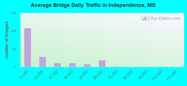
- 3,066,024Total average daily traffic
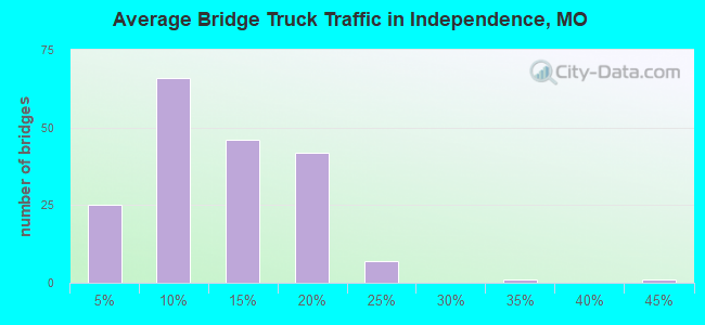
- 408,541Total average daily truck traffic
- National Bridge Inventory (NBI) Registered Bridges for Independence
- No street view available for this location
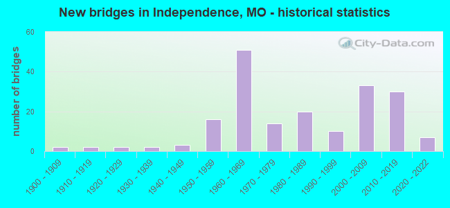
- New bridges - historical statistics
- 21900-1909
- 21910-1919
- 21920-1929
- 21930-1939
- 31940-1949
- 161950-1959
- 511960-1969
- 141970-1979
- 201980-1989
- 101990-1999
- 332000-2009
- 302010-2019
- 72020-2022
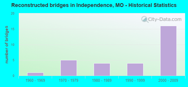
- Reconstructed bridges - Historical Statistics
- 11960-1969
- 51970-1979
- 41980-1989
- 41990-1999
- 162000-2009
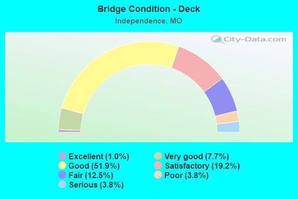
- Bridge Condition - Deck
- 1.0%Excellent
- 7.7%Very good
- 51.9%Good
- 19.2%Satisfactory
- 12.5%Fair
- 3.8%Poor
- 3.8%Serious
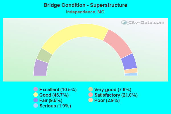
- Bridge Condition - Superstructure
- 10.5%Excellent
- 7.6%Very good
- 46.7%Good
- 21.0%Satisfactory
- 9.5%Fair
- 2.9%Poor
- 1.9%Serious
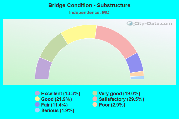
- Bridge Condition - Substructure
- 13.3%Excellent
- 19.0%Very good
- 21.9%Good
- 29.5%Satisfactory
- 11.4%Fair
- 2.9%Poor
- 1.9%Serious
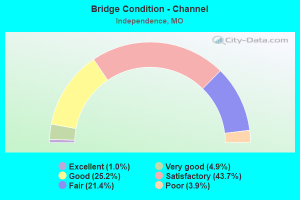
- Bridge Condition - Channel
- 1.0%Excellent
- 4.9%Very good
- 25.2%Good
- 43.7%Satisfactory
- 21.4%Fair
- 3.9%Poor
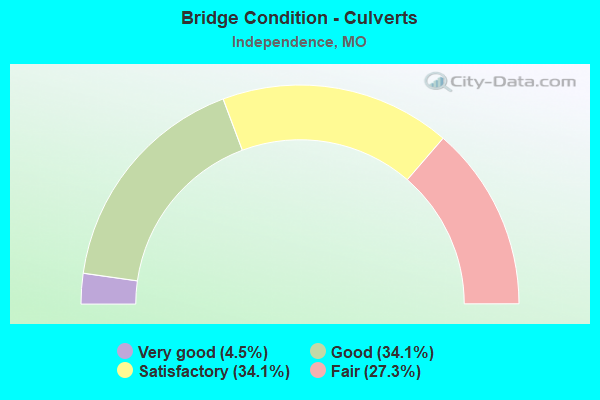
- Bridge Condition - Culverts
- 4.5%Very good
- 34.1%Good
- 34.1%Satisfactory
- 27.3%Fair
Find on map >> Show street view
Structure Number: 6639, Location: S 21 T 49 N R 32 W (Lat: 39.047231, Lng: -94.442792), Route carried "under" structure: US 40, Year Built: 1962, Structure Length: 0. m, Average Daily Traffic: 6,834 (year 2021), Truck Traffic: 12%, Features Intersected: US 40, Facility Carried by Structure: IS 70 W
Minimum Vertical Clearance: 4.50m (14.76ft), Kilometerpoint: 18.396, Lanes on structure: 3, Lanes under structure: 3, Material/Design: Concrete continuous, Design/Construction: Box Beam or Girders - Single/Spread, Length of Maximum Span: 32.0m (105.0ft)
Find on map >> Show street view
Structure Number: 6639, Location: S 21 T 49 N R 32 W (Lat: 39.047231, Lng: -94.442792), Route carried "under" structure: US 40, Year Built: 1962, Structure Length: 0. m, Average Daily Traffic: 7,196 (year 2021), Truck Traffic: 8%, Features Intersected: US 40, Facility Carried by Structure: IS 70 W
Minimum Vertical Clearance: 4.47m (14.67ft), Kilometerpoint: 393.411, Lanes on structure: 3, Lanes under structure: 3, Material/Design: Concrete continuous, Design/Construction: Box Beam or Girders - Single/Spread, Length of Maximum Span: 32.0m (105.0ft)
Find on map >> Show street view
Structure Number: 6651, Location: S 21 T 49 N R 32 W (Lat: 39.047050, Lng: -94.439494), Route carried "under" structure: Interstate 70, Year Built: 1962, Structure Length: 0. m, Average Daily Traffic: 57,121 (year 2021), Truck Traffic: 18%, Features Intersected: IS 70, Facility Carried by Structure: BLUE RIDGE BLVD S
Minimum Vertical Clearance: 4.90m (16.08ft), Kilometerpoint: 384.158, Lanes on structure: 3, Lanes under structure: 4, Material/Design: Concrete continuous, Design/Construction: Box Beam or Girders - Single/Spread, Length of Maximum Span: 25.0m (82.0ft)
Find on map >> Show street view
Structure Number: 6651, Location: S 21 T 49 N R 32 W (Lat: 39.047050, Lng: -94.439494), Route carried "under" structure: Interstate 70, Year Built: 1962, Structure Length: 0. m, Average Daily Traffic: 55,742 (year 2021), Truck Traffic: 18%, Features Intersected: IS 70, Facility Carried by Structure: BLUE RIDGE BLVD S
Minimum Vertical Clearance: 4.80m (15.75ft), Kilometerpoint: 18.168, Lanes on structure: 3, Lanes under structure: 3, Material/Design: Concrete continuous, Design/Construction: Box Beam or Girders - Single/Spread, Length of Maximum Span: 25.0m (82.0ft)
Find on map >> Show street view
Structure Number: 746, Location: S 19 T 49 N R 32 W (Lat: 39.055828, Lng: -94.493833), Route carried "under" structure: Interstate 435, Year Built: 1962, Structure Length: 0. m, Average Daily Traffic: 36,355 (year 2021), Truck Traffic: 12%, Features Intersected: IS 435, Facility Carried by Structure: STADIUM DR E
Minimum Vertical Clearance: 6.15m (20.18ft), Kilometerpoint: 68.520, Lanes on structure: 1, Lanes under structure: 4, Material/Design: Steel continuous, Design/Construction: Stringer/Multi-beam, Length of Maximum Span: 27.7m (90.9ft)
Find on map >> Show street view
Structure Number: 746, Location: S 19 T 49 N R 32 W (Lat: 39.055828, Lng: -94.493833), Route carried "under" structure: Interstate 435, Year Built: 1962, Structure Length: 0. m, Average Daily Traffic: 42,374 (year 2021), Truck Traffic: 12%, Features Intersected: IS 435, Facility Carried by Structure: STADIUM DR E
Minimum Vertical Clearance: 6.15m (20.18ft), Kilometerpoint: 20.326, Lanes on structure: 1, Lanes under structure: 4, Material/Design: Steel continuous, Design/Construction: Stringer/Multi-beam, Length of Maximum Span: 27.7m (90.9ft)