Bridge Statistics for Independence, Missouri (MO)
Condition, Traffic, Stress, Structural Evaluation, Project Costs
- National Bridge Inventory (NBI) Statistics
- 192Number of bridges
- 2,431ft / 741mTotal length
- $14,570,000Total costs
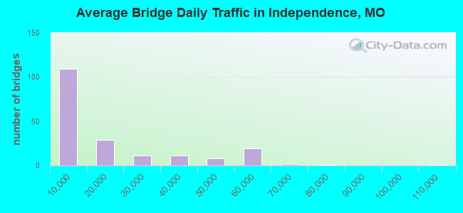
- 3,066,024Total average daily traffic
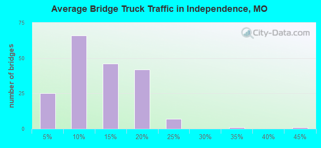
- 408,541Total average daily truck traffic
- National Bridge Inventory (NBI) Registered Bridges for Independence
- No street view available for this location
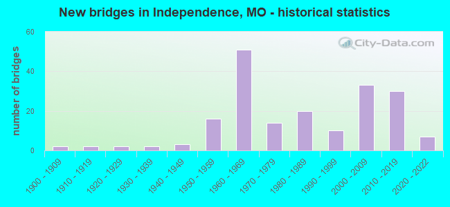
- New bridges - historical statistics
- 21900-1909
- 21910-1919
- 21920-1929
- 21930-1939
- 31940-1949
- 161950-1959
- 511960-1969
- 141970-1979
- 201980-1989
- 101990-1999
- 332000-2009
- 302010-2019
- 72020-2022
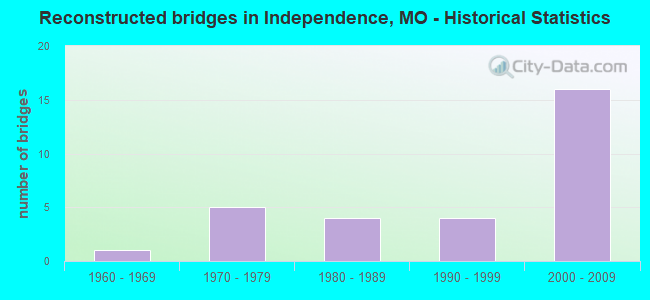
- Reconstructed bridges - Historical Statistics
- 11960-1969
- 51970-1979
- 41980-1989
- 41990-1999
- 162000-2009
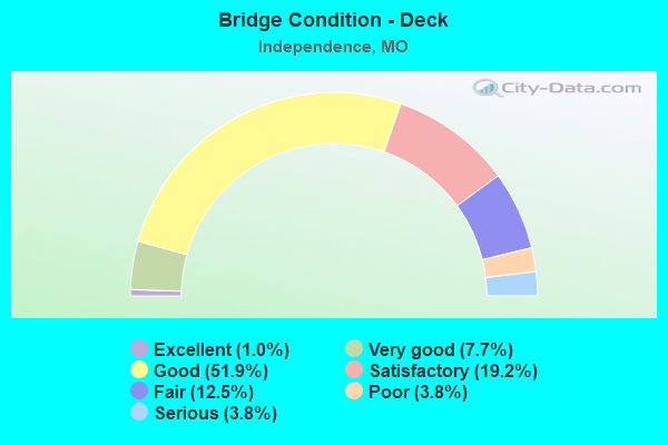
- Bridge Condition - Deck
- 1.0%Excellent
- 7.7%Very good
- 51.9%Good
- 19.2%Satisfactory
- 12.5%Fair
- 3.8%Poor
- 3.8%Serious
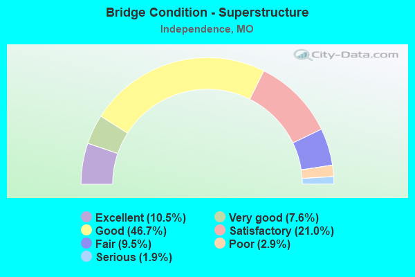
- Bridge Condition - Superstructure
- 10.5%Excellent
- 7.6%Very good
- 46.7%Good
- 21.0%Satisfactory
- 9.5%Fair
- 2.9%Poor
- 1.9%Serious
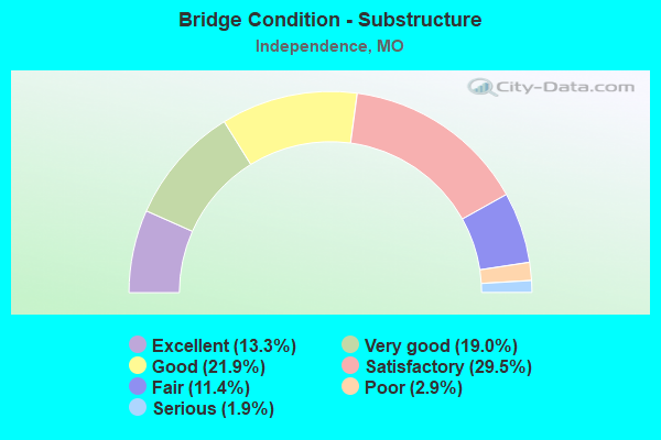
- Bridge Condition - Substructure
- 13.3%Excellent
- 19.0%Very good
- 21.9%Good
- 29.5%Satisfactory
- 11.4%Fair
- 2.9%Poor
- 1.9%Serious
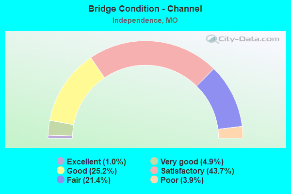
- Bridge Condition - Channel
- 1.0%Excellent
- 4.9%Very good
- 25.2%Good
- 43.7%Satisfactory
- 21.4%Fair
- 3.9%Poor
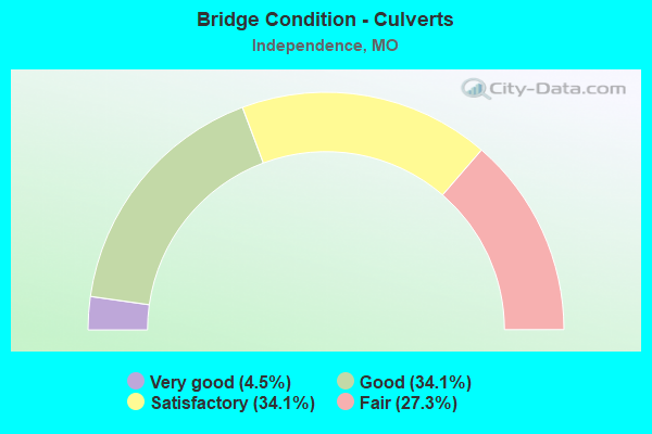
- Bridge Condition - Culverts
- 4.5%Very good
- 34.1%Good
- 34.1%Satisfactory
- 27.3%Fair
Find on map >> Show street view
Structure Number: 6636, Location: S 21 T 49 N R 32 W (Lat: 39.047244, Lng: -94.447622), Route carried "on" structure: Interstate 70, Year Built: 1962, Year Reconstructed: 1984, Status: Posted for load, Structure Length: 4.79m (15.72ft), Average Daily Traffic: 54,588 (year 2021), Truck Traffic: 18%, Average Future Daily Traffic: 73,694 (year 2041), Design Load: HS 20, Features Intersected: CST STERLING AVE
Minimum Vertical Clearance: 30+ m (98+ ft), Kilometerpoint: 17.434, Lanes on structure: 4, Lanes under structure: 4, Base Highway Network: Yes, Owner: State Highway Agency, Approaching Roadway Width: 16.5m (54.1ft), Material/Design: Steel continuous, Design/Construction: Stringer/Multi-beam, Number Of Spans In Main Unit: 3, Length of Maximum Span: 18.3m (60.0ft), Curb or Sidewalk Widths: Left: 0.2m (0.7ft), Right: 0.2m (0.7ft), Curb-To-Curb Width: 18.4m (60.4ft), Out-to-Out Width: 19.3m (63.3ft)
Condition: Deck: Satisfactory, Superstructure: Satisfactory, Substructure: Satisfactory, Operating Rating: 48.6 metric tons, Method Used To Determine Operating Rating: Load Factor (LF), Inventory Rating: 28.8 metric tons, Method Used To Determine Inventory Rating: Load Factor (LF), Structural Evaluation: Equal to present minimum criteria, Deck Geometry: Meets minimum limits, Underclear: Meets minimum limits, Approach Roadway Alignment: Equal to present desirable criteria, Designated Inspection Frequency: Every 24 months, Inspection Date: September 2021, Deck Structure Type: Concrete Cast-file-Place, Wearing Surface/Protective System: Wearing Surface: Latex Concrete
Find on map >> Show street view
Structure Number: 6637, Location: S 21 T 49 N R 32 W (Lat: 39.047453, Lng: -94.447617), Route carried "on" structure: Interstate 70, Year Built: 1962, Year Reconstructed: 1984, Status: Posted for load, Structure Length: 4.79m (15.72ft), Average Daily Traffic: 54,673 (year 2021), Truck Traffic: 18%, Average Future Daily Traffic: 73,809 (year 2041), Design Load: HS 20, Features Intersected: CST STERLING AVE
Minimum Vertical Clearance: 30+ m (98+ ft), Kilometerpoint: 384.835, Lanes on structure: 4, Lanes under structure: 4, Base Highway Network: Yes, Owner: State Highway Agency, Approaching Roadway Width: 16.5m (54.1ft), Material/Design: Steel continuous, Design/Construction: Stringer/Multi-beam, Number Of Spans In Main Unit: 3, Length of Maximum Span: 18.3m (60.0ft), Curb or Sidewalk Widths: Left: 0.2m (0.7ft), Right: 0.2m (0.7ft), Curb-To-Curb Width: 18.4m (60.4ft), Out-to-Out Width: 19.3m (63.3ft)
Condition: Deck: Satisfactory, Superstructure: Satisfactory, Substructure: Satisfactory, Operating Rating: 48.6 metric tons, Method Used To Determine Operating Rating: Load Factor (LF), Inventory Rating: 28.8 metric tons, Method Used To Determine Inventory Rating: Load Factor (LF), Structural Evaluation: Equal to present minimum criteria, Deck Geometry: Meets minimum limits, Underclear: Meets minimum limits, Approach Roadway Alignment: Equal to present desirable criteria, Designated Inspection Frequency: Every 24 months, Inspection Date: September 2021, Deck Structure Type: Concrete Cast-file-Place, Wearing Surface/Protective System: Wearing Surface: Latex Concrete, Membrane: Built-up
Find on map >> Show street view
Structure Number: 6638, Location: S 21 T 49 N R 32 W (Lat: 39.047097, Lng: -94.442511), Route carried "on" structure: Interstate 70, Year Built: 1962, Year Reconstructed: 2011, Status: Open, Structure Length: 12.62m (41.40ft), Average Daily Traffic: 54,588 (year 2021), Truck Traffic: 18%, Average Future Daily Traffic: 73,694 (year 2041), Design Load: HS 20+Mod, Features Intersected: US 40
Minimum Vertical Clearance: 30+ m (98+ ft), Kilometerpoint: 17.840, Lanes on structure: 3, Lanes under structure: 6, Base Highway Network: Yes, Owner: State Highway Agency, Approaching Roadway Width: 16.5m (54.1ft), Skew: 17 degrees, Material/Design: Concrete continuous, Design/Construction: Box Beam or Girders - Single/Spread, Number Of Spans In Main Unit: 4, Length of Maximum Span: 32.0m (105.0ft), Curb or Sidewalk Widths: Left: 0.2m (0.7ft), Right: 0.2m (0.7ft), Curb-To-Curb Width: 15.1m (49.5ft), Out-to-Out Width: 15.8m (51.8ft)
Condition: Deck: Fair, Superstructure: Fair, Substructure: Satisfactory, Operating Rating: 60.3 metric tons, Method Used To Determine Operating Rating: Load Factor (LF), Inventory Rating: 36.0 metric tons, Method Used To Determine Inventory Rating: Load Factor (LF), Structural Evaluation: Somewhat better than minimum adequacy, Deck Geometry: Meets minimum limits, Underclear: Meets minimum limits, Approach Roadway Alignment: Equal to present desirable criteria, Designated Inspection Frequency: Every 24 months, Inspection Date: September 2021, Deck Structure Type: Concrete Cast-file-Place, Wearing Surface/Protective System: Wearing Surface: Latex Concrete
Find on map >> Show street view
Structure Number: 6639, Location: S 21 T 49 N R 32 W (Lat: 39.047231, Lng: -94.442792), Route carried "on" structure: Interstate 70, Year Built: 1962, Year Reconstructed: 2011, Status: Open, Structure Length: 12.62m (41.40ft), Average Daily Traffic: 57,121 (year 2021), Truck Traffic: 18%, Average Future Daily Traffic: 77,113 (year 2041), Design Load: HS 20+Mod, Features Intersected: US 40
Minimum Vertical Clearance: 30+ m (98+ ft), Kilometerpoint: 384.378, Lanes on structure: 3, Lanes under structure: 6, Base Highway Network: Yes, Owner: State Highway Agency, Approaching Roadway Width: 16.5m (54.1ft), Skew: 17 degrees, Material/Design: Concrete continuous, Design/Construction: Box Beam or Girders - Single/Spread, Number Of Spans In Main Unit: 4, Length of Maximum Span: 32.0m (105.0ft), Curb or Sidewalk Widths: Left: 0.2m (0.7ft), Right: 0.2m (0.7ft), Curb-To-Curb Width: 15.1m (49.5ft), Out-to-Out Width: 15.8m (51.8ft)
Condition: Deck: Fair, Superstructure: Fair, Substructure: Fair, Operating Rating: 60.3 metric tons, Method Used To Determine Operating Rating: Load Factor (LF), Inventory Rating: 36.0 metric tons, Method Used To Determine Inventory Rating: Load Factor (LF), Structural Evaluation: Somewhat better than minimum adequacy, Deck Geometry: Meets minimum limits, Underclear: Meets minimum limits, Approach Roadway Alignment: Equal to present desirable criteria, Designated Inspection Frequency: Every 24 months, Inspection Date: September 2021, Deck Structure Type: Concrete Cast-file-Place, Wearing Surface/Protective System: Wearing Surface: Latex Concrete
Find on map >> Show street view
Structure Number: 6651, Location: S 21 T 49 N R 32 W (Lat: 39.047050, Lng: -94.439494), Route carried "on" structure: City street , Year Built: 1962, Status: Open, Structure Length: 8.20m (26.90ft), Average Daily Traffic: 13,713 (year 2021), Truck Traffic: 5%, Average Future Daily Traffic: 18,513 (year 2041), Design Load: H 20, Features Intersected: IS 70, RP US40E TO IS70E, Facility Carried by Structure: BLUE RIDGE BLVD S
Minimum Vertical Clearance: 30+ m (98+ ft), Kilometerpoint: 9.275, Lanes on structure: 3, Lanes under structure: 8, Owner: State Highway Agency, Approaching Roadway Width: 14.6m (47.9ft), Material/Design: Concrete continuous, Design/Construction: Box Beam or Girders - Single/Spread, Number Of Spans In Main Unit: 4, Length of Maximum Span: 25.0m (82.0ft), Curb-To-Curb Width: 14.6m (47.9ft), Out-to-Out Width: 16.1m (52.8ft)
Condition: Deck: Serious, Superstructure: Serious, Substructure: Fair, Operating Rating: 68.4 metric tons, Method Used To Determine Operating Rating: Allowable Stress (AS), Inventory Rating: 26.1 metric tons, Method Used To Determine Inventory Rating: Allowable Stress (AS), Structural Evaluation: High priority of corrective action, Deck Geometry: Somewhat better than minimum adequacy, Underclear: High priority of replacement, Approach Roadway Alignment: Equal to present desirable criteria, Length Of Structure Improvement: 0.92m (3.02ft), Designated Inspection Frequency: Every 12 months, Inspection Date: September 2021, Bridge Improvement Cost: $1,486,000, Roadway Improvement Cost: $149,000, Total Project Cost: $2,228,000 ( Estimate for 2022), Deck Structure Type: Concrete Cast-file-Place, Wearing Surface/Protective System: Wearing Surface: Monolithic Concrete
Find on map >> Show street view
Structure Number: 7201, Location: S 22 T 61 N R 38 W (Lat: 40.079747, Lng: -95.172964), Route carried "on" structure: US 159, Year Built: 1960, Year Reconstructed: 2002, Status: Open, Structure Length: 2.83m (9.28ft), Average Daily Traffic: 139 (year 2021), Truck Traffic: 21%, Average Future Daily Traffic: 181 (year 2041), Design Load: H 15, Features Intersected: KIMSEY CR
Minimum Vertical Clearance: 30+ m (98+ ft), Kilometerpoint: 3.182, Lanes on structure: 2, Owner: State Highway Agency, Approaching Roadway Width: 6.1m (20.0ft), Material/Design: Steel, Design/Construction: Stringer/Multi-beam, Number Of Spans In Main Unit: 3, Length of Maximum Span: 11.3m (37.1ft), Curb-To-Curb Width: 6.7m (22.0ft), Out-to-Out Width: 7.7m (25.3ft)
Condition: Deck: Good, Superstructure: Good, Substructure: Satisfactory, Channel: Poor, Operating Rating: 63.9 metric tons, Method Used To Determine Operating Rating: Load Factor (LF), Inventory Rating: 38.7 metric tons, Method Used To Determine Inventory Rating: Load Factor (LF), Structural Evaluation: Equal to present minimum criteria, Deck Geometry: Meets minimum limits, Waterway Adequacy: Equal to present desirable criteria, Approach Roadway Alignment: Equal to present desirable criteria, Designated Inspection Frequency: Every 24 months, Inspection Date: November 2021, Deck Structure Type: Concrete Cast-file-Place, Wearing Surface/Protective System: Wearing Surface: Monolithic Concrete, Deck Protection: Epoxy Coated Reinforcing
Find on map >> Show street view
Structure Number: 7203, Location: S 15 T 44 N R 22 W (Lat: 38.585950, Lng: -93.334292), Route carried "on" structure: State highway E, Year Built: 1959, Year Reconstructed: 2009, Status: Open, Structure Length: 8.05m (26.41ft), Average Daily Traffic: 763 (year 2021), Truck Traffic: 19%, Average Future Daily Traffic: 1,221 (year 2041), Design Load: H 15, Features Intersected: FLAT CR
Minimum Vertical Clearance: 30+ m (98+ ft), Kilometerpoint: 6.495, Lanes on structure: 2, Owner: State Highway Agency, Approaching Roadway Width: 6.7m (22.0ft), Skew: 2 degrees, Material/Design: Steel continuous, Design/Construction: Stringer/Multi-beam, Number Of Spans In Main Unit: 3, Length of Maximum Span: 30.5m (100.1ft), Curb-To-Curb Width: 6.7m (22.0ft), Out-to-Out Width: 7.5m (24.6ft)
Condition: Deck: Good, Superstructure: Very good, Substructure: Good, Channel: Good, Operating Rating: 38.7 metric tons, Method Used To Determine Operating Rating: Load Factor (LF), Inventory Rating: 23.4 metric tons, Method Used To Determine Inventory Rating: Load Factor (LF), Structural Evaluation: Equal to present minimum criteria, Deck Geometry: Meets minimum limits, Waterway Adequacy: Equal to present desirable criteria, Approach Roadway Alignment: Equal to present desirable criteria, Designated Inspection Frequency: Every 24 months, Inspection Date: January 2022, Deck Structure Type: Concrete Cast-file-Place, Wearing Surface/Protective System: Wearing Surface: Monolithic Concrete, Deck Protection: Epoxy Coated Reinforcing
Find on map >> Show street view
Structure Number: 7204, Location: S 28 T 52 N R 22 W (Lat: 39.288056, Lng: -93.378942), Route carried "on" structure: State highway B, Year Built: 1959, Status: Open, Structure Length: 1.07m (3.51ft), Average Daily Traffic: 126 (year 2021), Truck Traffic: 12%, Average Future Daily Traffic: 158 (year 2041), Design Load: H 10, Features Intersected: DRAIN DTCH
Minimum Vertical Clearance: 30+ m (98+ ft), Kilometerpoint: 12.056, Lanes on structure: 2, Owner: State Highway Agency, Approaching Roadway Width: 7.3m (24.0ft), Skew: 4 degrees, Material/Design: Concrete continuous, Design/Construction: Culvert, Number Of Spans In Main Unit: 2, Length of Maximum Span: 3.7m (12.1ft), Curb-To-Curb Width: 9.8m (32.2ft), Out-to-Out Width: 10.5m (34.4ft)
Condition: Channel: Satisfactory, Culverts: Satisfactory, Operating Rating: 66.6 metric tons, Method Used To Determine Operating Rating: Load Factor (LF), Inventory Rating: 39.6 metric tons, Method Used To Determine Inventory Rating: Load Factor (LF), Structural Evaluation: Equal to present minimum criteria, Deck Geometry: Better than present minimum criteria, Waterway Adequacy: Equal to present desirable criteria, Approach Roadway Alignment: Equal to present minimum criteria, Designated Inspection Frequency: Every 24 months, Inspection Date: November 2020
Find on map >> Show street view
Structure Number: 7205, Location: S 28 T 52 N R 22 W (Lat: 39.294497, Lng: -93.377439), Route carried "on" structure: State highway B, Year Built: 1959, Status: Posted for load, Structure Length: 3.75m (12.30ft), Average Daily Traffic: 126 (year 2021), Truck Traffic: 12%, Average Future Daily Traffic: 158 (year 2041), Design Load: H 10, Features Intersected: SAMBO CR
Minimum Vertical Clearance: 30+ m (98+ ft), Kilometerpoint: 12.754, Lanes on structure: 1, Owner: State Highway Agency, Approaching Roadway Width: 6.7m (22.0ft), Material/Design: Steel, Design/Construction: Stringer/Multi-beam, Number Of Spans In Main Unit: 3, Length of Maximum Span: 14.3m (46.9ft), Curb-To-Curb Width: 6.1m (20.0ft), Out-to-Out Width: 6.8m (22.3ft)
Condition: Deck: Serious, Superstructure: Satisfactory, Substructure: Satisfactory, Channel: Fair, Operating Rating: 20.7 metric tons, Method Used To Determine Operating Rating: Allowable Stress (AS), Inventory Rating: 12.6 metric tons, Method Used To Determine Inventory Rating: Allowable Stress (AS), Structural Evaluation: Meets minimum limits, Deck Geometry: Meets minimum limits, Waterway Adequacy: Somewhat better than minimum adequacy, Approach Roadway Alignment: Equal to present minimum criteria, Bridge Posting: Required (Relationship of Operating Rating to Maximum Legal Load: 20.0 - 29.9% below), Length Of Structure Improvement: 0.47m (1.54ft), Designated Inspection Frequency: Every 24 months, Inspection Date: October 2020, Bridge Improvement Cost: $327,000, Roadway Improvement Cost: $33,000, Total Project Cost: $490,000 ( Estimate for 2022), Deck Structure Type: Concrete Cast-file-Place, Wearing Surface/Protective System: Wearing Surface: Bituminous
Find on map >> Show street view
Structure Number: 7208, Location: S 3 T 39 N R 3 W (Lat: 38.128028, Lng: -91.244697), Route carried "on" structure: State highway JJ, Year Built: 1959, Status: Open, Structure Length: 0.92m (3.02ft), Average Daily Traffic: 780 (year 2021), Truck Traffic: 9%, Average Future Daily Traffic: 1,092 (year 2041), Design Load: H 15, Features Intersected: BOURBON BR
Minimum Vertical Clearance: 30+ m (98+ ft), Kilometerpoint: 3.151, Lanes on structure: 2, Owner: State Highway Agency, Approaching Roadway Width: 7.3m (24.0ft), Skew: 3 degrees, Material/Design: Concrete continuous, Design/Construction: Culvert, Number Of Spans In Main Unit: 2, Length of Maximum Span: 3.7m (12.1ft), Curb-To-Curb Width: 7.7m (25.3ft), Out-to-Out Width: 8.3m (27.2ft)
Condition: Channel: Satisfactory, Culverts: Good, Operating Rating: 63.0 metric tons, Method Used To Determine Operating Rating: Load Factor (LF), Inventory Rating: 37.8 metric tons, Method Used To Determine Inventory Rating: Load Factor (LF), Structural Evaluation: Better than present minimum criteria, Deck Geometry: Meets minimum limits, Waterway Adequacy: Equal to present minimum criteria, Approach Roadway Alignment: Equal to present minimum criteria, Designated Inspection Frequency: Every 24 months, Inspection Date: September 2020
Find on map >> Show street view
Structure Number: 7244, Location: S 20 T 23 N R 2 W (Lat: 36.634225, Lng: -91.207608), Route carried "on" structure: State highway Y, Year Built: 1960, Status: Open, Structure Length: 1.20m (3.94ft), Average Daily Traffic: 46 (year 2021), Truck Traffic: 16%, Average Future Daily Traffic: 64 (year 2041), Design Load: H 15, Features Intersected: BROCK CR
Minimum Vertical Clearance: 30+ m (98+ ft), Kilometerpoint: 1.743, Lanes on structure: 2, Owner: State Highway Agency, Approaching Roadway Width: 7.3m (24.0ft), Skew: 3 degrees, Material/Design: Concrete continuous, Design/Construction: Culvert, Number Of Spans In Main Unit: 3, Length of Maximum Span: 3.4m (11.2ft), Curb-To-Curb Width: 7.8m (25.6ft), Out-to-Out Width: 8.4m (27.6ft)
Condition: Channel: Satisfactory, Culverts: Satisfactory, Operating Rating: 64.8 metric tons, Method Used To Determine Operating Rating: Load Factor (LF), Inventory Rating: 38.7 metric tons, Method Used To Determine Inventory Rating: Load Factor (LF), Structural Evaluation: Equal to present minimum criteria, Deck Geometry: Equal to present minimum criteria, Waterway Adequacy: Equal to present minimum criteria, Approach Roadway Alignment: Equal to present minimum criteria, Designated Inspection Frequency: Every 24 months, Inspection Date: January 2022
Find on map >> Show street view
Structure Number: 746, Location: S 19 T 49 N R 32 W (Lat: 39.055828, Lng: -94.493833), Route carried "on" structure: City street , Year Built: 1962, Status: Posted for load, Structure Length: 9.08m (29.79ft), Average Daily Traffic: 4,502 (year 2021), Truck Traffic: 10%, Average Future Daily Traffic: 6,078 (year 2041), Design Load: H 20, Features Intersected: IS 435, Facility Carried by Structure: STADIUM DR E
Minimum Vertical Clearance: 30+ m (98+ ft), Kilometerpoint: 2.981, Lanes on structure: 1, Lanes under structure: 8, Owner: State Highway Agency, Approaching Roadway Width: 8.5m (27.9ft), Skew: 1 degrees, Material/Design: Steel continuous, Design/Construction: Stringer/Multi-beam, Number Of Spans In Main Unit: 4, Length of Maximum Span: 27.7m (90.9ft), Curb-To-Curb Width: 8.5m (27.9ft), Out-to-Out Width: 10.0m (32.8ft)
Condition: Deck: Good, Superstructure: Satisfactory, Substructure: Good, Operating Rating: 41.4 metric tons, Method Used To Determine Operating Rating: Load Factor (LF), Inventory Rating: 25.2 metric tons, Method Used To Determine Inventory Rating: Load Factor (LF), Structural Evaluation: Equal to present minimum criteria, Deck Geometry: Meets minimum limits, Underclear: High priority of corrective action, Approach Roadway Alignment: Equal to present minimum criteria, Designated Inspection Frequency: Every 24 months, Inspection Date: September 2021, Deck Structure Type: Concrete Cast-file-Place, Wearing Surface/Protective System: Wearing Surface: Monolithic Concrete
Find on map >> Show street view
Structure Number: 8502, Location: S 7 T 27 N R 11 W (Lat: 37.041058, Lng: -92.188347), Route carried "on" structure: State highway EE, Year Built: 1955, Status: Open, Structure Length: 0.64m (2.10ft), Average Daily Traffic: 448 (year 2021), Truck Traffic: 11%, Average Future Daily Traffic: 694 (year 2041), Features Intersected: BR OF N FK OF WHIT
Minimum Vertical Clearance: 30+ m (98+ ft), Kilometerpoint: 11.478, Lanes on structure: 2, Owner: State Highway Agency, Approaching Roadway Width: 7.3m (24.0ft), Material/Design: Steel, Design/Construction: Culvert, Number Of Spans In Main Unit: 7, Length of Maximum Span: 0.6m (2.0ft), Curb-To-Curb Width: 6.1m (20.0ft), Out-to-Out Width: 6.1m (20.0ft)
Condition: Channel: Fair, Culverts: Fair, Structural Evaluation: Somewhat better than minimum adequacy, Deck Geometry: High priority of corrective action, Waterway Adequacy: High priority of replacement, Approach Roadway Alignment: Meets minimum limits, Length Of Structure Improvement: 0.13m (0.43ft), Designated Inspection Frequency: Every 24 months, Inspection Date: January 2021, Bridge Improvement Cost: $170,000, Roadway Improvement Cost: $17,000, Total Project Cost: $255,000 ( Estimate for 2022)
Find on map >> Show street view
Structure Number: 8505, Location: S 26 T 27 N R 3 W (Lat: 36.984881, Lng: -91.256258), Route carried "on" structure: State highway W, Year Built: 1955, Status: Open, Structure Length: 0.67m (2.20ft), Average Daily Traffic: 113 (year 2021), Truck Traffic: 17%, Average Future Daily Traffic: 158 (year 2041), Features Intersected: PIKE CR
Minimum Vertical Clearance: 30+ m (98+ ft), Kilometerpoint: 0.290, Lanes on structure: 2, Owner: State Highway Agency, Approaching Roadway Width: 7.3m (24.0ft), Material/Design: Concrete, Design/Construction: Slab, Number Of Spans In Main Unit: 3, Length of Maximum Span: 1.8m (5.9ft), Curb-To-Curb Width: 5.5m (18.0ft), Out-to-Out Width: 5.5m (18.0ft)
Condition: Deck: Fair, Superstructure: Fair, Substructure: Fair, Channel: Good, Operating Rating: 23.4 metric tons, Method Used To Determine Operating Rating: Load Factor (LF), Inventory Rating: 13.5 metric tons, Method Used To Determine Inventory Rating: Load Factor (LF), Structural Evaluation: Meets minimum limits, Deck Geometry: High priority of corrective action, Waterway Adequacy: High priority of replacement, Approach Roadway Alignment: Meets minimum limits, Length Of Structure Improvement: 0.13m (0.43ft), Designated Inspection Frequency: Every 24 months, Inspection Date: December 2020, Bridge Improvement Cost: $134,000, Roadway Improvement Cost: $13,000, Total Project Cost: $201,000 ( Estimate for 2022), Deck Structure Type: Concrete Cast-file-Place, Wearing Surface/Protective System: Wearing Surface: Bituminous
Find on map >> Show street view
Structure Number: 8526, Location: S 21 T 31 N R 26 W (Lat: 37.402314, Lng: -93.801972), Route carried "on" structure: State highway O, Year Built: 1962, Year Reconstructed: 2009, Status: Open, Structure Length: 6.40m (21.00ft), Average Daily Traffic: 332 (year 2021), Truck Traffic: 5%, Average Future Daily Traffic: 432 (year 2041), Design Load: H 15, Features Intersected: TURNBACK CR
Minimum Vertical Clearance: 30+ m (98+ ft), Kilometerpoint: 2.124, Lanes on structure: 2, Owner: State Highway Agency, Approaching Roadway Width: 7.3m (24.0ft), Material/Design: Steel continuous, Design/Construction: Stringer/Multi-beam, Number Of Spans In Main Unit: 3, Length of Maximum Span: 24.7m (81.0ft), Curb-To-Curb Width: 7.3m (24.0ft), Out-to-Out Width: 8.7m (28.5ft)
Condition: Deck: Very good, Superstructure: Satisfactory, Substructure: Satisfactory, Channel: Good, Operating Rating: 25.2 metric tons, Method Used To Determine Operating Rating: Load Factor (LF), Inventory Rating: 15.3 metric tons, Method Used To Determine Inventory Rating: Load Factor (LF), Structural Evaluation: Meets minimum limits, Deck Geometry: Somewhat better than minimum adequacy, Waterway Adequacy: Equal to present desirable criteria, Approach Roadway Alignment: Meets minimum limits, Designated Inspection Frequency: Every 24 months, Inspection Date: November 2020, Deck Structure Type: Concrete Cast-file-Place, Wearing Surface/Protective System: Wearing Surface: Monolithic Concrete, Deck Protection: Epoxy Coated Reinforcing
Find on map >> Show street view
Structure Number: DAPAMCLAK000003, Location: EAST OF BLD 54A (Lat: 39.092600, Lng: -94.254161), Route carried "on" structure: Other road , Year Built: 1954, Status: Posted for load, Structure Length: 2.06m (6.76ft), Average Daily Traffic: 1 (year 2014), Average Future Daily Traffic: 1 (year 2043), Features Intersected: FIRE PRAIRIE CREEK, Facility Carried by Structure: BACKLINE ROAD
Minimum Vertical Clearance: 30+ m (98+ ft), Kilometerpoint: 0.000, Lanes on structure: 2, Owner: Army, Approaching Roadway Width: 6.1m (20.0ft), Material/Design: Steel continuous, Design/Construction: Stringer/Multi-beam, Number Of Spans In Main Unit: 3, Length of Maximum Span: 7.6m (24.9ft), Curb or Sidewalk Widths: Left: 0.2m (0.7ft), Right: 0.2m (0.7ft), Curb-To-Curb Width: 6.7m (22.0ft), Out-to-Out Width: 7.1m (23.3ft)
Condition: Deck: Satisfactory, Superstructure: Satisfactory, Substructure: Satisfactory, Channel: Good, Operating Rating: 57.8 metric tons, Method Used To Determine Operating Rating: Load Factor (LF), Inventory Rating: 34.6 metric tons, Method Used To Determine Inventory Rating: Load Factor (LF), Structural Evaluation: Equal to present minimum criteria, Deck Geometry: Somewhat better than minimum adequacy, Waterway Adequacy: Equal to present desirable criteria, Approach Roadway Alignment: Equal to present desirable criteria, Length Of Structure Improvement: 2.73m (8.96ft), Designated Inspection Frequency: Every 24 months, Inspection Date: August 2021, Bridge Improvement Cost: $1,000, Roadway Improvement Cost: $1,000, Total Project Cost: $2,000 ( Estimate for 2021), Deck Structure Type: Concrete Cast-file-Place, Wearing Surface/Protective System: Wearing Surface: Bituminous
Find on map >> Show street view
Structure Number: DAPAMCLAK000004, Location: WEST OF BLD 6 (Lat: 39.103061, Lng: -94.280339), Route carried "on" structure: Other road , Year Built: 1941, Status: Posted for load, Structure Length: 1.49m (4.89ft), Average Daily Traffic: 50 (year 2018), Average Future Daily Traffic: 20 (year 2043), Features Intersected: WEST FIRE PRAIRIE CREEK, Facility Carried by Structure: COMMANDER'S RIDGE
Minimum Vertical Clearance: 30+ m (98+ ft), Kilometerpoint: 0.000, Lanes on structure: 1, Owner: Army, Approaching Roadway Width: 3.7m (12.1ft), Material/Design: Steel, Design/Construction: Girder and Floorbeam System, Number Of Spans In Main Unit: 1, Length of Maximum Span: 13.0m (42.7ft), Curb-To-Curb Width: 5.2m (17.1ft), Out-to-Out Width: 6.1m (20.0ft)
Condition: Deck: Fair, Superstructure: Satisfactory, Substructure: Satisfactory, Channel: Good, Operating Rating: 16.2 metric tons, Method Used To Determine Operating Rating: Load and Resistance Factor Rating (LRFR) rating reported by rating factor(RF) method using HL-93 loadings, Inventory Rating: 12.3 metric tons, Method Used To Determine Inventory Rating: Load and Resistance Factor Rating (LRFR) rating reported by rating factor(RF) method using HL-93 loadings, Structural Evaluation: Meets minimum limits, Deck Geometry: High priority of corrective action, Waterway Adequacy: Equal to present desirable criteria, Approach Roadway Alignment: High priority of corrective action, Bridge Posting: Required (Relationship of Operating Rating to Maximum Legal Load: > 39.9% below), Length Of Structure Improvement: 2.13m (6.99ft), Designated Inspection Frequency: Every 24 months, Critical Feature Inspection Frequency: Every 24 months, Inspection Date: August 2021, Critical Feature Inspection Date: August 2021, Bridge Improvement Cost: $1,000, Roadway Improvement Cost: $1,000, Total Project Cost: $2,000 ( Estimate for 2021), Deck Structure Type: Concrete Cast-file-Place, Wearing Surface/Protective System: Wearing Surface: Bituminous
Find on map >> Show street view
Structure Number: DAPAMCLAK000005, Location: N OF EXPLOSIVE AREA 19 (Lat: 39.096181, Lng: -94.262800), Route carried "on" structure: Other road , Year Built: 1954, Status: Posted for load, Structure Length: 2.06m (6.76ft), Average Daily Traffic: 1,000 (year 2018), Truck Traffic: 20%, Average Future Daily Traffic: 100 (year 2043), Features Intersected: WEST FIRE PRAIRIE CREEK, Facility Carried by Structure: HARRY TRUMAN DR
Minimum Vertical Clearance: 30+ m (98+ ft), Kilometerpoint: 0.000, Lanes on structure: 2, Owner: Army, Approaching Roadway Width: 6.4m (21.0ft), Material/Design: Steel continuous, Design/Construction: Stringer/Multi-beam, Number Of Spans In Main Unit: 3, Length of Maximum Span: 7.6m (24.9ft), Curb or Sidewalk Widths: Left: 0.2m (0.7ft), Right: 0.2m (0.7ft), Curb-To-Curb Width: 6.7m (22.0ft), Out-to-Out Width: 7.2m (23.6ft)
Condition: Deck: Poor, Superstructure: Poor, Substructure: Fair, Channel: Good, Operating Rating: 53.8 metric tons, Method Used To Determine Operating Rating: Load Factor (LF), Inventory Rating: 32.2 metric tons, Method Used To Determine Inventory Rating: Load Factor (LF), Structural Evaluation: Meets minimum limits, Deck Geometry: Meets minimum limits, Waterway Adequacy: Equal to present desirable criteria, Approach Roadway Alignment: Equal to present desirable criteria, Length Of Structure Improvement: 2.73m (8.96ft), Designated Inspection Frequency: Every 24 months, Inspection Date: August 2021, Bridge Improvement Cost: $1,000, Roadway Improvement Cost: $1,000, Total Project Cost: $2,000 ( Estimate for 2021), Deck Structure Type: Concrete Cast-file-Place, Wearing Surface/Protective System: Wearing Surface: Bituminous
Find on map >> Show street view
Structure Number: DAPAMCLAK000006, Location: NE OF FACILITY 108K (Lat: 39.083200, Lng: -94.256819), Route carried "on" structure: Other road , Year Built: 1984, Status: Open, Structure Length: 5.12m (16.80ft), Average Daily Traffic: 50 (year 2018), Average Future Daily Traffic: 100 (year 2043), Design Load: H 15, Features Intersected: WEST FIRE PRAIRIE CREEK, Facility Carried by Structure: OWENS SCHOOL ROAD
Minimum Vertical Clearance: 30+ m (98+ ft), Kilometerpoint: 0.000, Lanes on structure: 2, Owner: Army, Approaching Roadway Width: 7.3m (24.0ft), Material/Design: Steel continuous, Design/Construction: Stringer/Multi-beam, Number Of Spans In Main Unit: 3, Length of Maximum Span: 19.5m (64.0ft), Curb-To-Curb Width: 7.3m (24.0ft), Out-to-Out Width: 8.3m (27.2ft)
Condition: Deck: Good, Superstructure: Good, Substructure: Good, Channel: Good, Operating Rating: 30.8 metric tons, Method Used To Determine Operating Rating: Load and Resistance Factor Rating (LRFR) rating reported by rating factor(RF) method using HL-93 loadings, Inventory Rating: 24.0 metric tons, Method Used To Determine Inventory Rating: Load and Resistance Factor Rating (LRFR) rating reported by rating factor(RF) method using HL-93 loadings, Structural Evaluation: Equal to present minimum criteria, Deck Geometry: Equal to present minimum criteria, Waterway Adequacy: Equal to present desirable criteria, Approach Roadway Alignment: Equal to present minimum criteria, Length Of Structure Improvement: 6.08m (19.95ft), Designated Inspection Frequency: Every 24 months, Inspection Date: August 2021, Bridge Improvement Cost: $1,000, Roadway Improvement Cost: $1,000, Total Project Cost: $2,000 ( Estimate for 2021), Deck Structure Type: Concrete Cast-file-Place
Find on map >> Show street view
Structure Number: DAPAMCLAK000007, Location: NE OF RESIDENTIAL AREA (Lat: 39.089031, Lng: -94.268050), Route carried "on" structure: Other road , Year Built: 1984, Status: Open, Structure Length: 4.48m (14.70ft), Average Daily Traffic: 50 (year 2018), Truck Traffic: 30%, Average Future Daily Traffic: 50 (year 2043), Design Load: H 15, Features Intersected: WEST FIRE PRAIRIE CREEK, Facility Carried by Structure: COMMANDERS RIDGE R
Minimum Vertical Clearance: 30+ m (98+ ft), Kilometerpoint: 0.000, Lanes on structure: 2, Owner: Army, Approaching Roadway Width: 7.3m (24.0ft), Material/Design: Steel continuous, Design/Construction: Stringer/Multi-beam, Number Of Spans In Main Unit: 3, Length of Maximum Span: 17.4m (57.1ft), Curb-To-Curb Width: 7.3m (24.0ft), Out-to-Out Width: 8.4m (27.6ft)
Condition: Deck: Good, Superstructure: Fair, Substructure: Good, Channel: Satisfactory, Operating Rating: 53.7 metric tons, Method Used To Determine Operating Rating: Load Factor (LF), Inventory Rating: 32.1 metric tons, Method Used To Determine Inventory Rating: Load Factor (LF), Structural Evaluation: Somewhat better than minimum adequacy, Deck Geometry: Equal to present minimum criteria, Waterway Adequacy: Equal to present desirable criteria, Approach Roadway Alignment: Equal to present minimum criteria, Length Of Structure Improvement: 5.47m (17.95ft), Designated Inspection Frequency: Every 24 months, Inspection Date: August 2021, Bridge Improvement Cost: $1,000, Roadway Improvement Cost: $1,000, Total Project Cost: $2,000 ( Estimate for 2021), Deck Structure Type: Concrete Cast-file-Place
Find on map >> Show street view
Structure Number: DAPAMCLAK000008, Location: EAST OF HWY 7 (Lat: 39.094661, Lng: -94.281661), Route carried "on" structure: Other road , Year Built: 1984, Status: Posted for load, Structure Length: 5.36m (17.59ft), Average Daily Traffic: 50 (year 2018), Truck Traffic: 20%, Average Future Daily Traffic: 50 (year 2043), Design Load: HS 15, Features Intersected: WEST FIRE PRAIRIE CREEK, Facility Carried by Structure: COMMANDERS RIDGE
Minimum Vertical Clearance: 30+ m (98+ ft), Kilometerpoint: 0.000, Lanes on structure: 1, Owner: Army, Approaching Roadway Width: 4.3m (14.1ft), Material/Design: Steel continuous, Design/Construction: Stringer/Multi-beam, Number Of Spans In Main Unit: 3, Length of Maximum Span: 18.3m (60.0ft), Curb-To-Curb Width: 5.0m (16.4ft), Out-to-Out Width: 5.9m (19.4ft)
Condition: Deck: Good, Superstructure: Good, Substructure: Good, Channel: Good, Operating Rating: 16.2 metric tons, Method Used To Determine Operating Rating: Load and Resistance Factor Rating (LRFR) rating reported by rating factor(RF) method using HL-93 loadings, Inventory Rating: 12.6 metric tons, Method Used To Determine Inventory Rating: Load and Resistance Factor Rating (LRFR) rating reported by rating factor(RF) method using HL-93 loadings, Structural Evaluation: Meets minimum limits, Deck Geometry: High priority of corrective action, Waterway Adequacy: Equal to present desirable criteria, Approach Roadway Alignment: Equal to present desirable criteria, Bridge Posting: Required (Relationship of Operating Rating to Maximum Legal Load: 10.0 - 19.9% below), Length Of Structure Improvement: 6.15m (20.18ft), Designated Inspection Frequency: Every 24 months, Critical Feature Inspection Frequency: Every 24 months, Inspection Date: August 2021, Critical Feature Inspection Date: August 2021, Bridge Improvement Cost: $1,000, Roadway Improvement Cost: $1,000, Total Project Cost: $2,000 ( Estimate for 2021), Deck Structure Type: Concrete Cast-file-Place
Find on map >> Show street view
Structure Number: DAPAMCLAK0000C5, Location: NORTH OF BLD 121B (Lat: 39.107289, Lng: -94.255281), Route carried "on" structure: Other road , Year Built: 1941, Status: Open, Structure Length: 0.79m (2.59ft), Truck Traffic: 40%, Average Future Daily Traffic: 100 (year 2043), Features Intersected: DITCH B, Facility Carried by Structure: OWENS SCHOOL ROAD
Minimum Vertical Clearance: 30+ m (98+ ft), Kilometerpoint: 0.000, Lanes on structure: 1, Owner: Army, Approaching Roadway Width: 6.7m (22.0ft), Material/Design: Concrete, Design/Construction: Culvert, Number Of Spans In Main Unit: 3, Length of Maximum Span: 2.4m (7.9ft), Curb-To-Curb Width: 9.4m (30.8ft), Out-to-Out Width: 9.8m (32.2ft)
Condition: Channel: Good, Culverts: Satisfactory, Operating Rating: 42.4 metric tons, Method Used To Determine Operating Rating: Field evaluation and documented engineering judgment, Inventory Rating: 32.7 metric tons, Method Used To Determine Inventory Rating: Field evaluation and documented engineering judgment, Structural Evaluation: Equal to present minimum criteria, Deck Geometry: Better than present minimum criteria, Waterway Adequacy: Better than present minimum criteria, Approach Roadway Alignment: Equal to present desirable criteria, Length Of Structure Improvement: 1.44m (4.72ft), Designated Inspection Frequency: Every 24 months, Inspection Date: August 2021, Bridge Improvement Cost: $1,000, Roadway Improvement Cost: $1,000, Total Project Cost: $1,000 ( Estimate for 2021)
Find on map >> Show street view
Structure Number: DAPAMCLAK0000C6, Location: EAST OF BLD 181KK (Lat: 39.095600, Lng: -94.253739), Route carried "on" structure: Other road , Year Built: 1981, Status: Open, Structure Length: 0.97m (3.18ft), Average Daily Traffic: 200 (year 2018), Truck Traffic: 1%, Average Future Daily Traffic: 4 (year 2043), Features Intersected: FIRE PRAIRIE CREEK, Facility Carried by Structure: LINDER ROAD
Minimum Vertical Clearance: 30+ m (98+ ft), Kilometerpoint: 0.000, Lanes on structure: 2, Owner: Army, Approaching Roadway Width: 7.3m (24.0ft), Skew: 2 degrees, Material/Design: Steel, Design/Construction: Culvert, Number Of Spans In Main Unit: 2, Length of Maximum Span: 4.3m (14.1ft)
Condition: Channel: Good, Culverts: Good, Operating Rating: 97.2 metric tons, Method Used To Determine Operating Rating: Load and Resistance Factor Rating (LRFR) rating reported by rating factor(RF) method using HL-93 loadings, Inventory Rating: 97.2 metric tons, Method Used To Determine Inventory Rating: Load and Resistance Factor Rating (LRFR) rating reported by rating factor(RF) method using HL-93 loadings, Structural Evaluation: Better than present minimum criteria, Waterway Adequacy: Better than present minimum criteria, Approach Roadway Alignment: Equal to present desirable criteria, Length Of Structure Improvement: 1.05m (3.44ft), Designated Inspection Frequency: Every 24 months, Inspection Date: August 2021, Bridge Improvement Cost: $1,000, Roadway Improvement Cost: $1,000, Total Project Cost: $2,000 ( Estimate for 2021)
Find on map >> Show street view
Structure Number: DAPAMCLAK0000T4, Location: WEST OF T3 (Lat: 39.110089, Lng: -94.241461), Route carried "on" structure: Other road , Year Built: 2012, Status: Open, Structure Length: 1.22m (4.00ft), Average Daily Traffic: 50 (year 2014), Average Future Daily Traffic: 50 (year 2043), Features Intersected: FIRE PRAIRIE CREEK, Facility Carried by Structure: PERIMETER NORTH
Minimum Vertical Clearance: 30+ m (98+ ft), Kilometerpoint: 0.000, Lanes on structure: 1, Owner: Army, Approaching Roadway Width: 3.4m (11.2ft), Material/Design: Concrete, Design/Construction: Culvert, Number Of Spans In Main Unit: 3, Length of Maximum Span: 3.7m (12.1ft)
Condition: Channel: Satisfactory, Culverts: Good, Operating Rating: 42.4 metric tons, Method Used To Determine Operating Rating: Field evaluation and documented engineering judgment, Inventory Rating: 32.7 metric tons, Method Used To Determine Inventory Rating: Field evaluation and documented engineering judgment, Structural Evaluation: Better than present minimum criteria, Waterway Adequacy: Equal to present minimum criteria, Approach Roadway Alignment: Equal to present desirable criteria, Length Of Structure Improvement: 1.90m (6.23ft), Designated Inspection Frequency: Every 24 months, Inspection Date: August 2021, Bridge Improvement Cost: $1,000, Roadway Improvement Cost: $1,000, Total Project Cost: $2,000 ( Estimate for 2021)
Find on map >> Show street view
Structure Number: 1105, Location: S 20 T 49 N R 31 W (Lat: 39.048139, Lng: -94.364047), Route carried "under" structure: City street , Year Built: 1964, Structure Length: 0. m, Average Daily Traffic: 17,759 (year 2021), Truck Traffic: 5%, Features Intersected: CST 39TH ST, Facility Carried by Structure: MO 291 S
Minimum Vertical Clearance: 4.50m (14.76ft), Kilometerpoint: 7.604, Lanes on structure: 3, Lanes under structure: 6, Material/Design: Steel continuous, Design/Construction: Stringer/Multi-beam, Length of Maximum Span: 24.4m (80.1ft)
Find on map >> Show street view
Structure Number: 1106, Location: S 20 T 49 N R 31 W (Lat: 39.048139, Lng: -94.363672), Route carried "under" structure: City street , Year Built: 1964, Structure Length: 0. m, Average Daily Traffic: 20,088 (year 2021), Truck Traffic: 5%, Features Intersected: CST 39TH ST, Facility Carried by Structure: MO 291 N
Minimum Vertical Clearance: 5.11m (16.77ft), Kilometerpoint: 7.636, Lanes on structure: 3, Lanes under structure: 6, Material/Design: Steel continuous, Design/Construction: Stringer/Multi-beam, Length of Maximum Span: 24.4m (80.1ft)
Find on map >> Show street view
Structure Number: 1115, Location: S 29 T 49 N R 31 W (Lat: 39.033319, Lng: -94.361247), Route carried "under" structure: US 40, Year Built: 1965, Structure Length: 0. m, Average Daily Traffic: 8,326 (year 2021), Truck Traffic: 2%, Features Intersected: US 40, Facility Carried by Structure: IS 470 E
Minimum Vertical Clearance: 4.88m (16.01ft), Kilometerpoint: 25.944, Lanes on structure: 2, Lanes under structure: 4, Material/Design: Steel continuous, Design/Construction: Stringer/Multi-beam, Length of Maximum Span: 19.8m (65.0ft)
Find on map >> Show street view
Structure Number: 1115, Location: S 29 T 49 N R 31 W (Lat: 39.033319, Lng: -94.361247), Route carried "under" structure: US 40, Year Built: 1965, Structure Length: 0. m, Average Daily Traffic: 7,593 (year 2021), Truck Traffic: 8%, Features Intersected: US 40, Facility Carried by Structure: IS 470 E
Minimum Vertical Clearance: 4.65m (15.26ft), Kilometerpoint: 385.894, Lanes on structure: 2, Lanes under structure: 4, Material/Design: Steel continuous, Design/Construction: Stringer/Multi-beam, Length of Maximum Span: 19.8m (65.0ft)
Find on map >> Show street view
Structure Number: 1116, Location: S 29 T 49 N R 31 W (Lat: 39.033389, Lng: -94.361578), Route carried "under" structure: US 40, Year Built: 1965, Structure Length: 0. m, Average Daily Traffic: 7,593 (year 2021), Truck Traffic: 8%, Features Intersected: US 40, Facility Carried by Structure: IS 470 W
Minimum Vertical Clearance: 4.65m (15.26ft), Kilometerpoint: 385.923, Lanes on structure: 2, Lanes under structure: 4, Material/Design: Steel continuous, Design/Construction: Stringer/Multi-beam, Length of Maximum Span: 19.8m (65.0ft)
Find on map >> Show street view
Structure Number: 1116, Location: S 29 T 49 N R 31 W (Lat: 39.033389, Lng: -94.361578), Route carried "under" structure: US 40, Year Built: 1965, Structure Length: 0. m, Average Daily Traffic: 8,326 (year 2021), Truck Traffic: 2%, Features Intersected: US 40, Facility Carried by Structure: IS 470 W
Minimum Vertical Clearance: 4.90m (16.08ft), Kilometerpoint: 25.915, Lanes on structure: 2, Lanes under structure: 3, Material/Design: Steel continuous, Design/Construction: Stringer/Multi-beam, Length of Maximum Span: 19.8m (65.0ft)
Find on map >> Show street view
Structure Number: 1118, Location: S 20 T 49 N R 31 W (Lat: 39.041814, Lng: -94.362367), Route carried "under" structure: Interstate 70, Year Built: 1964, Structure Length: 0. m, Average Daily Traffic: 50,764 (year 2021), Truck Traffic: 18%, Features Intersected: IS 70
Minimum Vertical Clearance: 5.41m (17.75ft), Kilometerpoint: 24.874, Lanes on structure: 3, Lanes under structure: 4, Material/Design: Concrete continuous, Design/Construction: Slab, Length of Maximum Span: 20.4m (66.9ft)
Find on map >> Show street view
Structure Number: 1118, Location: S 20 T 49 N R 31 W (Lat: 39.041814, Lng: -94.362367), Route carried "under" structure: Interstate 70, Year Built: 1964, Structure Length: 0. m, Average Daily Traffic: 53,837 (year 2021), Truck Traffic: 24%, Features Intersected: IS 70
Minimum Vertical Clearance: 5.94m (19.49ft), Kilometerpoint: 377.445, Lanes on structure: 3, Lanes under structure: 4, Material/Design: Concrete continuous, Design/Construction: Slab, Length of Maximum Span: 20.4m (66.9ft)
Find on map >> Show street view
Structure Number: 1119, Location: S 20 T 49 N R 31 W (Lat: 39.041869, Lng: -94.362689), Route carried "under" structure: Interstate 70, Year Built: 1964, Structure Length: 0. m, Average Daily Traffic: 50,764 (year 2021), Truck Traffic: 18%, Features Intersected: IS 70
Minimum Vertical Clearance: 5.28m (17.32ft), Kilometerpoint: 24.845, Lanes on structure: 3, Lanes under structure: 4, Material/Design: Concrete continuous, Design/Construction: Slab, Length of Maximum Span: 20.4m (66.9ft)
Find on map >> Show street view
Structure Number: 1119, Location: S 20 T 49 N R 31 W (Lat: 39.041869, Lng: -94.362689), Route carried "under" structure: Interstate 70, Year Built: 1964, Structure Length: 0. m, Average Daily Traffic: 50,688 (year 2021), Truck Traffic: 18%, Features Intersected: IS 70
Minimum Vertical Clearance: 5.87m (19.26ft), Kilometerpoint: 377.476, Lanes on structure: 3, Lanes under structure: 4, Material/Design: Concrete continuous, Design/Construction: Slab, Length of Maximum Span: 20.4m (66.9ft)
Find on map >> Show street view
Structure Number: 3131, Location: S 24 T 49 N R 32 W (Lat: 39.044878, Lng: -94.387333), Route carried "under" structure: Interstate 70, Year Built: 1983, Structure Length: 0. m, Average Daily Traffic: 50,688 (year 2021), Truck Traffic: 18%, Features Intersected: IS 70, Facility Carried by Structure: LEES SUMMIT RD S
Minimum Vertical Clearance: 5.66m (18.57ft), Kilometerpoint: 379.634, Lanes on structure: 6, Lanes under structure: 3, Material/Design: Steel continuous, Design/Construction: Stringer/Multi-beam, Length of Maximum Span: 32.7m (107.3ft)
Find on map >> Show street view
Structure Number: 3131, Location: S 24 T 49 N R 32 W (Lat: 39.044878, Lng: -94.387333), Route carried "under" structure: Interstate 70, Year Built: 1983, Structure Length: 0. m, Average Daily Traffic: 57,662 (year 2021), Truck Traffic: 18%, Features Intersected: IS 70, Facility Carried by Structure: LEES SUMMIT RD S
Minimum Vertical Clearance: 5.03m (16.50ft), Kilometerpoint: 22.684, Lanes on structure: 6, Lanes under structure: 3, Material/Design: Steel continuous, Design/Construction: Stringer/Multi-beam, Length of Maximum Span: 32.7m (107.3ft)
Find on map >> Show street view
Structure Number: 32183, Location: S 23 T 49 N R 32 W (Lat: 39.046031, Lng: -94.415128), Route carried "under" structure: Interstate 70, Year Built: 2008, Structure Length: 0. m, Average Daily Traffic: 55,742 (year 2021), Truck Traffic: 18%, Features Intersected: IS 70, Facility Carried by Structure: NOLAND RD S
Minimum Vertical Clearance: 5.61m (18.41ft), Kilometerpoint: 20.275, Lanes on structure: 7, Lanes under structure: 3, Material/Design: Prestressed concrete continuous, Design/Construction: Box Beam or Girders - Multiple, Length of Maximum Span: 24.7m (81.0ft)
Find on map >> Show street view
Structure Number: 32183, Location: S 23 T 49 N R 32 W (Lat: 39.046031, Lng: -94.415128), Route carried "under" structure: Interstate 70, Year Built: 2008, Structure Length: 0. m, Average Daily Traffic: 60,664 (year 2021), Truck Traffic: 18%, Features Intersected: IS 70, Facility Carried by Structure: NOLAND RD S
Minimum Vertical Clearance: 5.28m (17.32ft), Kilometerpoint: 382.044, Lanes on structure: 7, Lanes under structure: 3, Material/Design: Prestressed concrete continuous, Design/Construction: Box Beam or Girders - Multiple, Length of Maximum Span: 24.7m (81.0ft)
Find on map >> Show street view
Structure Number: 32184, Location: S 21 T 49 N R 31 W (Lat: 39.054225, Lng: -94.344669), Route carried "under" structure: County highway , Year Built: 2008, Structure Length: 0. m, Average Daily Traffic: 1,000 (year 2021), Truck Traffic: 5%, Features Intersected: SELSA RD, Facility Carried by Structure: LIT BLUE PARKWAY
Minimum Vertical Clearance: 30+ m (98+ ft), Kilometerpoint: 0.000, Lanes on structure: 4, Lanes under structure: 2, Material/Design: Prestressed concrete continuous, Design/Construction: Stringer/Multi-beam, Length of Maximum Span: 28.0m (91.9ft)
Find on map >> Show street view
Structure Number: 34825, Location: S 13 T 49 N R 33 W (Lat: 39.065778, Lng: -94.504403), Route carried "under" structure: City street , Year Built: 2014, Structure Length: 0. m, Average Daily Traffic: 5,984 (year 2021), Truck Traffic: 17%, Features Intersected: CST MANCHESTER TRFY, Facility Carried by Structure: IS 70 W
Minimum Vertical Clearance: 5.13m (16.83ft), Kilometerpoint: 2.989, Lanes on structure: 4, Lanes under structure: 4, Material/Design: Prestressed concrete, Design/Construction: Tee Beam, Length of Maximum Span: 51.2m (168.0ft)
Find on map >> Show street view
Structure Number: 34827, Location: S 13 T 49 N R 33 W (Lat: 39.065642, Lng: -94.504378), Route carried "under" structure: City street , Year Built: 2014, Structure Length: 0. m, Average Daily Traffic: 5,984 (year 2021), Truck Traffic: 17%, Features Intersected: CST MANCHESTER TRFY, Facility Carried by Structure: IS 70 E
Minimum Vertical Clearance: 5.17m (16.96ft), Kilometerpoint: 3.035, Lanes on structure: 4, Lanes under structure: 4, Material/Design: Prestressed concrete, Design/Construction: Tee Beam, Length of Maximum Span: 51.2m (168.0ft)
Find on map >> Show street view
Structure Number: 35736, Location: S 20 T 49 N R 32 W (Lat: 39.047933, Lng: -94.461597), Route carried "under" structure: Interstate 70, Year Built: 2018, Structure Length: 0. m, Average Daily Traffic: 54,588 (year 2021), Truck Traffic: 18%, Features Intersected: IS 70, Facility Carried by Structure: PITTMAN RD S
Minimum Vertical Clearance: 5.07m (16.63ft), Kilometerpoint: 16.248, Lanes on structure: 2, Lanes under structure: 3, Material/Design: Prestressed concrete, Design/Construction: Box Beam or Girders - Single/Spread, Length of Maximum Span: 24.7m (81.0ft)
Find on map >> Show street view
Structure Number: 35736, Location: S 20 T 49 N R 32 W (Lat: 39.047933, Lng: -94.461597), Route carried "under" structure: Interstate 70, Year Built: 2018, Structure Length: 0. m, Average Daily Traffic: 54,673 (year 2021), Truck Traffic: 18%, Features Intersected: IS 70, Facility Carried by Structure: PITTMAN RD S
Minimum Vertical Clearance: 6.78m (22.24ft), Kilometerpoint: 386.071, Lanes on structure: 2, Lanes under structure: 3, Material/Design: Prestressed concrete, Design/Construction: Box Beam or Girders - Single/Spread, Length of Maximum Span: 24.7m (81.0ft)
Find on map >> Show street view
Structure Number: 35747, Location: S 22 T 49 N R 32 W (Lat: 39.046672, Lng: -94.433669), Route carried "under" structure: Interstate 70, Year Built: 2018, Structure Length: 0. m, Average Daily Traffic: 55,742 (year 2021), Truck Traffic: 18%, Features Intersected: IS 70, Facility Carried by Structure: CRYSLER ST S
Minimum Vertical Clearance: 5.08m (16.67ft), Kilometerpoint: 18.668, Lanes on structure: 2, Lanes under structure: 3, Material/Design: Prestressed concrete, Design/Construction: Box Beam or Girders - Single/Spread, Length of Maximum Span: 24.7m (81.0ft)
Find on map >> Show street view
Structure Number: 35747, Location: S 22 T 49 N R 32 W (Lat: 39.046672, Lng: -94.433669), Route carried "under" structure: Interstate 70, Year Built: 2018, Structure Length: 0. m, Average Daily Traffic: 57,121 (year 2021), Truck Traffic: 18%, Features Intersected: IS 70, Facility Carried by Structure: CRYSLER ST S
Minimum Vertical Clearance: 5.13m (16.83ft), Kilometerpoint: 383.651, Lanes on structure: 2, Lanes under structure: 3, Material/Design: Prestressed concrete, Design/Construction: Box Beam or Girders - Single/Spread, Length of Maximum Span: 24.7m (81.0ft)
Find on map >> Show street view
Structure Number: 3575, Location: S 23 T 49 N R 32 W (Lat: 39.045575, Lng: -94.405203), Route carried "under" structure: Interstate 70, Year Built: 2018, Structure Length: 0. m, Average Daily Traffic: 57,662 (year 2021), Truck Traffic: 18%, Features Intersected: IS 70, Facility Carried by Structure: PHELPS RD S
Minimum Vertical Clearance: 5.13m (16.83ft), Kilometerpoint: 21.136, Lanes on structure: 2, Lanes under structure: 3, Material/Design: Prestressed concrete, Design/Construction: Box Beam or Girders - Single/Spread, Length of Maximum Span: 27.4m (89.9ft)
Find on map >> Show street view
Structure Number: 3575, Location: S 23 T 49 N R 32 W (Lat: 39.045575, Lng: -94.405203), Route carried "under" structure: Interstate 70, Year Built: 2018, Structure Length: 0. m, Average Daily Traffic: 60,664 (year 2021), Truck Traffic: 18%, Features Intersected: IS 70, Facility Carried by Structure: PHELPS RD S
Minimum Vertical Clearance: 5.13m (16.83ft), Kilometerpoint: 381.188, Lanes on structure: 2, Lanes under structure: 3, Material/Design: Prestressed concrete, Design/Construction: Box Beam or Girders - Single/Spread, Length of Maximum Span: 27.4m (89.9ft)
Find on map >> Show street view
Structure Number: 3597, Location: S 19 T 49 N R 32 W (Lat: 39.060553, Lng: -94.489331), Route carried "under" structure: Ramp State highway , Year Built: 2021, Structure Length: 0. m, Average Daily Traffic: 11,000 (year 2021), Truck Traffic: 10%, Features Intersected: RP IS435N TO IS70W, Facility Carried by Structure: IS 435 S
Minimum Vertical Clearance: 5.31m (17.42ft), Kilometerpoint: 0.901, Lanes on structure: 3, Lanes under structure: 1, Material/Design: Prestressed concrete, Design/Construction: Stringer/Multi-beam, Length of Maximum Span: 25.0m (82.0ft)
Find on map >> Show street view
Structure Number: 36291, Location: S 8 T 49 N R 32 W (Lat: 39.081439, Lng: -94.471139), Route carried "under" structure: State highway 78, Year Built: 2020, Structure Length: 0. m, Average Daily Traffic: 10,433 (year 2021), Truck Traffic: 4%, Features Intersected: MO 78, Facility Carried by Structure: BLUE RIDGE BLVD S
Minimum Vertical Clearance: 5.03m (16.50ft), Kilometerpoint: 2.350, Lanes on structure: 2, Lanes under structure: 2, Material/Design: Prestressed concrete, Design/Construction: Box Beam or Girders - Single/Spread, Length of Maximum Span: 26.3m (86.3ft)
Find on map >> Show street view
Structure Number: 36291, Location: S 8 T 49 N R 32 W (Lat: 39.081439, Lng: -94.471139), Route carried "under" structure: State highway 78, Year Built: 2020, Structure Length: 0. m, Average Daily Traffic: 10,814 (year 2021), Truck Traffic: 4%, Features Intersected: MO 78, Facility Carried by Structure: BLUE RIDGE BLVD S
Minimum Vertical Clearance: 4.76m (15.62ft), Kilometerpoint: 17.173, Lanes on structure: 2, Lanes under structure: 2, Material/Design: Prestressed concrete, Design/Construction: Box Beam or Girders - Single/Spread, Length of Maximum Span: 26.3m (86.3ft)
Find on map >> Show street view
Structure Number: 3888, Location: S 6 T 49 N R 31 W (Lat: 39.091386, Lng: -94.379675), Route carried "under" structure: City street , Year Built: 1990, Structure Length: 0. m, Average Daily Traffic: 14,060 (year 2021), Truck Traffic: 6%, Features Intersected: CST TRUMAN RD, Facility Carried by Structure: MO 291 S
Minimum Vertical Clearance: 6.39m (20.96ft), Kilometerpoint: 17.352, Lanes on structure: 6, Lanes under structure: 5, Material/Design: Prestressed concrete continuous, Design/Construction: Stringer/Multi-beam, Length of Maximum Span: 24.7m (81.0ft)
Find on map >> Show street view
Structure Number: 3948, Location: S 25 T 50 N R 32 W (Lat: 39.117072, Lng: -94.384869), Route carried "under" structure: State highway 291, Year Built: 1989, Structure Length: 0. m, Average Daily Traffic: 17,853 (year 2021), Truck Traffic: 14%, Features Intersected: MO 291, Facility Carried by Structure: US 24 E
Minimum Vertical Clearance: 5.11m (16.77ft), Kilometerpoint: 52.915, Lanes on structure: 7, Lanes under structure: 2, Material/Design: Prestressed concrete continuous, Design/Construction: Stringer/Multi-beam, Length of Maximum Span: 27.3m (89.6ft)
Find on map >> Show street view
Structure Number: 3948, Location: S 25 T 50 N R 32 W (Lat: 39.117072, Lng: -94.384869), Route carried "under" structure: State highway 291, Year Built: 1989, Structure Length: 0. m, Average Daily Traffic: 9,669 (year 2021), Truck Traffic: 13%, Features Intersected: MO 291, Facility Carried by Structure: US 24 E
Minimum Vertical Clearance: 5.54m (18.18ft), Kilometerpoint: 26.540, Lanes on structure: 7, Lanes under structure: 2, Material/Design: Prestressed concrete continuous, Design/Construction: Stringer/Multi-beam, Length of Maximum Span: 27.3m (89.6ft)
Find on map >> Show street view
Structure Number: 608, Location: S 8 T 48 N R 32 W (Lat: 39.000594, Lng: -94.482336), Route carried "under" structure: State highway 350, Year Built: 1954, Structure Length: 0. m, Average Daily Traffic: 14,444 (year 2021), Truck Traffic: 5%, Features Intersected: MO 350, Facility Carried by Structure: BLUE RIDGE BLVD N
Minimum Vertical Clearance: 4.67m (15.32ft), Kilometerpoint: 3.349, Lanes on structure: 5, Lanes under structure: 2, Material/Design: Steel continuous, Design/Construction: Stringer/Multi-beam, Length of Maximum Span: 28.7m (94.2ft)
Find on map >> Show street view
Structure Number: 608, Location: S 8 T 48 N R 32 W (Lat: 39.000594, Lng: -94.482336), Route carried "under" structure: State highway 350, Year Built: 1954, Structure Length: 0. m, Average Daily Traffic: 14,422 (year 2021), Truck Traffic: 6%, Features Intersected: MO 350, Facility Carried by Structure: BLUE RIDGE BLVD N
Minimum Vertical Clearance: 4.32m (14.17ft), Kilometerpoint: 10.358, Lanes on structure: 5, Lanes under structure: 2, Material/Design: Steel continuous, Design/Construction: Stringer/Multi-beam, Length of Maximum Span: 28.7m (94.2ft)
Find on map >> Show street view
Structure Number: 663, Location: S 13 T 49 N R 33 W (Lat: 39.068781, Lng: -94.511242), Route carried "under" structure: US 40, Year Built: 1960, Structure Length: 0. m, Average Daily Traffic: 5,628 (year 2021), Truck Traffic: 9%, Features Intersected: US 40, Facility Carried by Structure: IS 70 E
Minimum Vertical Clearance: 4.65m (15.26ft), Kilometerpoint: 11.751, Lanes on structure: 4, Lanes under structure: 5, Material/Design: Steel continuous, Design/Construction: Stringer/Multi-beam, Length of Maximum Span: 29.9m (98.1ft)
Find on map >> Show street view
Structure Number: 6631, Location: S 13 T 49 N R 33 W (Lat: 39.068856, Lng: -94.511006), Route carried "under" structure: US 40, Year Built: 1960, Structure Length: 0. m, Average Daily Traffic: 5,628 (year 2021), Truck Traffic: 9%, Features Intersected: US 40, Facility Carried by Structure: IS 70 W
Minimum Vertical Clearance: 4.67m (15.32ft), Kilometerpoint: 11.774, Lanes on structure: 4, Lanes under structure: 5, Material/Design: Steel continuous, Design/Construction: Stringer/Multi-beam, Length of Maximum Span: 29.9m (98.1ft)
Find on map >> Show street view
Structure Number: 6636, Location: S 21 T 49 N R 32 W (Lat: 39.047244, Lng: -94.447622), Route carried "under" structure: City street , Year Built: 1962, Structure Length: 0. m, Average Daily Traffic: 11,814 (year 2021), Truck Traffic: 5%, Features Intersected: CST STERLING AVE, Facility Carried by Structure: IS 70 E
Minimum Vertical Clearance: 4.52m (14.83ft), Kilometerpoint: 8.172, Lanes on structure: 4, Lanes under structure: 4, Material/Design: Steel continuous, Design/Construction: Stringer/Multi-beam, Length of Maximum Span: 18.3m (60.0ft)
Find on map >> Show street view
Structure Number: 6637, Location: S 21 T 49 N R 32 W (Lat: 39.047453, Lng: -94.447617), Route carried "under" structure: City street , Year Built: 1962, Structure Length: 0. m, Average Daily Traffic: 11,814 (year 2021), Truck Traffic: 5%, Features Intersected: CST STERLING AVE, Facility Carried by Structure: IS 70 W
Minimum Vertical Clearance: 4.52m (14.83ft), Kilometerpoint: 8.150, Lanes on structure: 4, Lanes under structure: 4, Material/Design: Steel continuous, Design/Construction: Stringer/Multi-beam, Length of Maximum Span: 18.3m (60.0ft)
Find on map >> Show street view
Structure Number: 6638, Location: S 21 T 49 N R 32 W (Lat: 39.047097, Lng: -94.442511), Route carried "under" structure: US 40, Year Built: 1962, Structure Length: 0. m, Average Daily Traffic: 8,325 (year 2021), Truck Traffic: 2%, Features Intersected: US 40, Facility Carried by Structure: IS 70 E
Minimum Vertical Clearance: 4.50m (14.76ft), Kilometerpoint: 18.421, Lanes on structure: 3, Lanes under structure: 3, Material/Design: Concrete continuous, Design/Construction: Box Beam or Girders - Single/Spread, Length of Maximum Span: 32.0m (105.0ft)
Find on map >> Show street view
Structure Number: 6638, Location: S 21 T 49 N R 32 W (Lat: 39.047097, Lng: -94.442511), Route carried "under" structure: US 40, Year Built: 1962, Structure Length: 0. m, Average Daily Traffic: 8,187 (year 2021), Truck Traffic: 2%, Features Intersected: US 40, Facility Carried by Structure: IS 70 E
Minimum Vertical Clearance: 4.50m (14.76ft), Kilometerpoint: 393.384, Lanes on structure: 3, Lanes under structure: 3, Material/Design: Concrete continuous, Design/Construction: Box Beam or Girders - Single/Spread, Length of Maximum Span: 32.0m (105.0ft)