Bridge Statistics for Iowa City, Iowa (IA)
Condition, Traffic, Stress, Structural Evaluation, Project Costs

- New bridges - historical statistics
- 11900-1909
- 41910-1919
- 11920-1929
- 31930-1939
- 11940-1949
- 71950-1959
- 201960-1969
- 151970-1979
- 201980-1989
- 121990-1999
- 102000-2009
- 52010-2019
- 52020-2022
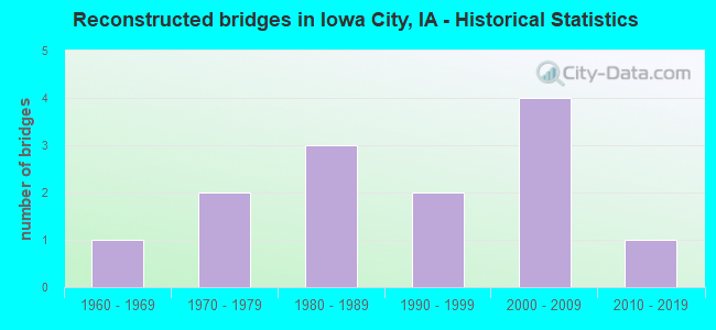
- Reconstructed bridges - Historical Statistics
- 11960-1969
- 21970-1979
- 31980-1989
- 21990-1999
- 42000-2009
- 12010-2019
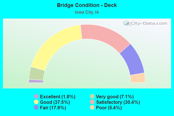
- Bridge Condition - Deck
- 1.8%Excellent
- 7.1%Very good
- 37.5%Good
- 30.4%Satisfactory
- 17.9%Fair
- 5.4%Poor
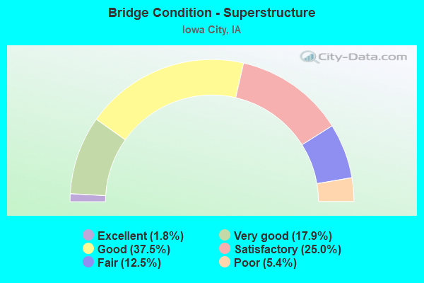
- Bridge Condition - Superstructure
- 1.8%Excellent
- 17.9%Very good
- 37.5%Good
- 25.0%Satisfactory
- 12.5%Fair
- 5.4%Poor
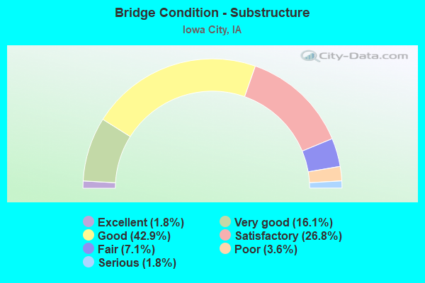
- Bridge Condition - Substructure
- 1.8%Excellent
- 16.1%Very good
- 42.9%Good
- 26.8%Satisfactory
- 7.1%Fair
- 3.6%Poor
- 1.8%Serious
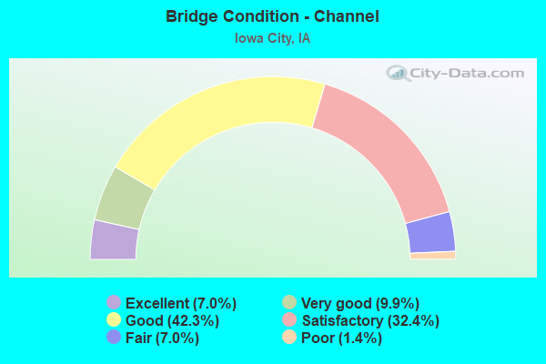
- Bridge Condition - Channel
- 7.0%Excellent
- 9.9%Very good
- 42.3%Good
- 32.4%Satisfactory
- 7.0%Fair
- 1.4%Poor
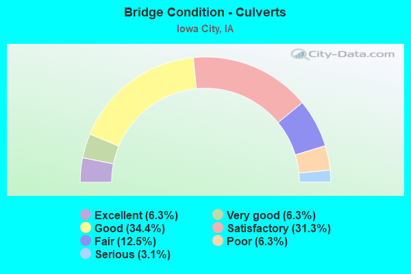
- Bridge Condition - Culverts
- 6.3%Excellent
- 6.3%Very good
- 34.4%Good
- 31.3%Satisfactory
- 12.5%Fair
- 6.3%Poor
- 3.1%Serious
Find on map >> Show street view
Structure Number: 6251, Location: 000000000 (Lat: 41.650650, Lng: -91.538933), Route carried "on" structure: City street , Year Built: 1990, Status: Open, Structure Length: 14.60m (47.90ft), Average Daily Traffic: 15,100 (year 2018), Average Future Daily Traffic: 15,100 (year 2041), Design Load: HS 20, Features Intersected: IOWA RIVER, Facility Carried by Structure: BENTON ST
Minimum Vertical Clearance: 30+ m (98+ ft), Kilometerpoint: 1.717, Lanes on structure: 4, Owner: City or Municipal Highway Agency, Approaching Roadway Width: 18.3m (60.0ft), Material/Design: Steel continuous, Design/Construction: Stringer/Multi-beam, Number Of Spans In Main Unit: 5, Length of Maximum Span: 36.6m (120.1ft), Curb or Sidewalk Widths: Left: 2.4m (7.9ft), Right: 2.4m (7.9ft), Curb-To-Curb Width: 17.1m (56.1ft), Out-to-Out Width: 23.4m (76.8ft)
Condition: Deck: Good, Superstructure: Good, Substructure: Good, Channel: Good, Operating Rating: 63.6 metric tons, Method Used To Determine Operating Rating: Load Factor (LF), Inventory Rating: 38.1 metric tons, Method Used To Determine Inventory Rating: Load Factor (LF), Structural Evaluation: Better than present minimum criteria, Deck Geometry: Somewhat better than minimum adequacy, Waterway Adequacy: Equal to present desirable criteria, Approach Roadway Alignment: Better than present minimum criteria, Length Of Structure Improvement: 47.90m (157.15ft), Designated Inspection Frequency: Every 24 months, Inspection Date: June 2021, Bridge Improvement Cost: $15,000, Roadway Improvement Cost: $2,000, Deck Structure Type: Concrete Cast-file-Place, Wearing Surface/Protective System: Wearing Surface: Monolithic Concrete, Deck Protection: Epoxy Coated Reinforcing
Find on map >> Show street view
Structure Number: 63, Location: 000000000 (Lat: 41.653925, Lng: -91.514683), Route carried "on" structure: City street , Year Built: 1957, Status: Open, Structure Length: 0.67m (2.20ft), Average Daily Traffic: 350 (year 1975), Average Future Daily Traffic: 350 (year 2041), Design Load: HS 20, Features Intersected: RALSTON CREEK, Facility Carried by Structure: CENTER AVE
Minimum Vertical Clearance: 30+ m (98+ ft), Kilometerpoint: 0.153, Lanes on structure: 2, Owner: City or Municipal Highway Agency, Approaching Roadway Width: 7.3m (24.0ft), Material/Design: Concrete, Design/Construction: Frame, Number Of Spans In Main Unit: 1, Length of Maximum Span: 6.1m (20.0ft), Curb or Sidewalk Widths: Left: 1.8m (5.9ft), Right: 1.8m (5.9ft), Curb-To-Curb Width: 7.3m (24.0ft), Out-to-Out Width: 12.6m (41.3ft)
Condition: Deck: Fair, Superstructure: Poor, Substructure: Satisfactory, Channel: Satisfactory, Operating Rating: 37.9 metric tons, Method Used To Determine Operating Rating: Field evaluation and documented engineering judgment, Inventory Rating: 29.0 metric tons, Method Used To Determine Inventory Rating: Field evaluation and documented engineering judgment, Structural Evaluation: Meets minimum limits, Deck Geometry: Somewhat better than minimum adequacy, Waterway Adequacy: Equal to present minimum criteria, Approach Roadway Alignment: Equal to present minimum criteria, Length Of Structure Improvement: 2.20m (7.22ft), Designated Inspection Frequency: Every 24 months, Inspection Date: June 2021, Bridge Improvement Cost: $25,000, Roadway Improvement Cost: $3,000, Deck Structure Type: Concrete Cast-file-Place, Wearing Surface/Protective System: Wearing Surface: Monolithic Concrete
Find on map >> Show street view
Structure Number: 631, Location: 000000000 (Lat: 41.656908, Lng: -91.552933), Route carried "on" structure: City street , Year Built: 1997, Status: Open, Structure Length: 6.28m (20.60ft), Average Daily Traffic: 12,600 (year 2018), Average Future Daily Traffic: 12,600 (year 2039), Features Intersected: IAIS RR, Facility Carried by Structure: MELROSE AVE
Minimum Vertical Clearance: 30+ m (98+ ft), Kilometerpoint: 3.866, Lanes on structure: 3, Owner: City or Municipal Highway Agency, Approaching Roadway Width: 9.1m (29.9ft), Skew: 4 degrees, Material/Design: Steel continuous, Design/Construction: Stringer/Multi-beam, Number Of Spans In Main Unit: 3, Length of Maximum Span: 22.3m (73.2ft), Curb or Sidewalk Widths: Left: 2.4m (7.9ft), Right: 2.4m (7.9ft), Curb-To-Curb Width: 13.1m (43.0ft), Out-to-Out Width: 19.4m (63.6ft)
Condition: Deck: Good, Superstructure: Good, Substructure: Good, Channel: Good, Operating Rating: 55.1 metric tons, Method Used To Determine Operating Rating: Load Factor (LF), Inventory Rating: 33.0 metric tons, Method Used To Determine Inventory Rating: Load Factor (LF), Structural Evaluation: Better than present minimum criteria, Deck Geometry: Meets minimum limits, Underclear: Somewhat better than minimum adequacy, Approach Roadway Alignment: Equal to present desirable criteria, Length Of Structure Improvement: 20.60m (67.59ft), Designated Inspection Frequency: Every 48 months, Inspection Date: June 2019, Bridge Improvement Cost: $15,000, Roadway Improvement Cost: $2,000, Deck Structure Type: Concrete Cast-file-Place, Wearing Surface/Protective System: Wearing Surface: Monolithic Concrete
Find on map >> Show street view
Structure Number: 632, Location: 000000000 (Lat: 41.661836, Lng: -91.515108), Route carried "on" structure: City street , Year Built: 1958, Status: Open, Structure Length: 0.67m (2.20ft), Average Daily Traffic: 2,270 (year 2002), Average Future Daily Traffic: 2,270 (year 2041), Design Load: HS 20, Features Intersected: RALSTON CREEK, Facility Carried by Structure: JEFFERSON ST
Minimum Vertical Clearance: 30+ m (98+ ft), Kilometerpoint: 0.373, Lanes on structure: 2, Owner: City or Municipal Highway Agency, Approaching Roadway Width: 9.1m (29.9ft), Skew: 1 degrees, Material/Design: Concrete, Design/Construction: Slab, Number Of Spans In Main Unit: 1, Length of Maximum Span: 6.1m (20.0ft), Curb or Sidewalk Widths: Left: 1.8m (5.9ft), Right: 1.8m (5.9ft), Curb-To-Curb Width: 9.4m (30.8ft), Out-to-Out Width: 13.0m (42.7ft)
Condition: Deck: Fair, Superstructure: Fair, Substructure: Satisfactory, Channel: Satisfactory, Operating Rating: 40.2 metric tons, Method Used To Determine Operating Rating: Field evaluation and documented engineering judgment, Inventory Rating: 31.0 metric tons, Method Used To Determine Inventory Rating: Field evaluation and documented engineering judgment, Structural Evaluation: Somewhat better than minimum adequacy, Deck Geometry: Meets minimum limits, Waterway Adequacy: Equal to present minimum criteria, Approach Roadway Alignment: Equal to present minimum criteria, Length Of Structure Improvement: 2.20m (7.22ft), Designated Inspection Frequency: Every 24 months, Inspection Date: June 2021, Bridge Improvement Cost: $25,000, Roadway Improvement Cost: $3,000, Deck Structure Type: Concrete Cast-file-Place, Wearing Surface/Protective System: Wearing Surface: Bituminous
Find on map >> Show street view
Structure Number: 6331, Location: 0790611 (Lat: 41.663903, Lng: -91.513714), Route carried "on" structure: City street , Year Built: 2014, Status: Open, Structure Length: 1.77m (5.81ft), Average Daily Traffic: 7,000 (year 2018), Average Future Daily Traffic: 7,000 (year 2041), Design Load: HL 93, Features Intersected: RALSTON CREEK, Facility Carried by Structure: ROCHESTER AVE
Minimum Vertical Clearance: 30+ m (98+ ft), Kilometerpoint: 0.475, Lanes on structure: 2, Owner: City or Municipal Highway Agency, Approaching Roadway Width: 11.0m (36.1ft), Material/Design: Prestressed concrete, Design/Construction: Stringer/Multi-beam, Number Of Spans In Main Unit: 1, Length of Maximum Span: 16.8m (55.1ft), Curb or Sidewalk Widths: Left: 2.7m (8.9ft), Right: 2.7m (8.9ft), Curb-To-Curb Width: 11.0m (36.1ft), Out-to-Out Width: 17.1m (56.1ft)
Condition: Deck: Good, Superstructure: Very good, Substructure: Very good, Channel: Very good, Operating Rating: 52.5 metric tons, Method Used To Determine Operating Rating: Load and Resistance Factor Rating (LRFR) rating reported by rating factor(RF) method using HL-93 loadings, Inventory Rating: 39.5 metric tons, Method Used To Determine Inventory Rating: Load and Resistance Factor Rating (LRFR) rating reported by rating factor(RF) method using HL-93 loadings, Structural Evaluation: Equal to present desirable criteria, Deck Geometry: Meets minimum limits, Waterway Adequacy: Equal to present desirable criteria, Approach Roadway Alignment: Equal to present desirable criteria, Designated Inspection Frequency: Every 24 months, Inspection Date: June 2021, Deck Structure Type: Concrete Cast-file-Place, Wearing Surface/Protective System: Wearing Surface: Monolithic Concrete, Deck Protection: Epoxy Coated Reinforcing
Find on map >> Show street view
Structure Number: 6351, Location: 079060300 (Lat: 41.671278, Lng: -91.534769), Route carried "on" structure: City street , Year Built: 2018, Status: Open, Structure Length: 13.52m (44.36ft), Average Daily Traffic: 6,900 (year 2018), Average Future Daily Traffic: 6,900 (year 2041), Design Load: HL 93, Features Intersected: IOWA RIVER, Facility Carried by Structure: PARK RD
Minimum Vertical Clearance: 30+ m (98+ ft), Kilometerpoint: 1.455, Lanes on structure: 4, Owner: City or Municipal Highway Agency, Approaching Roadway Width: 27.4m (89.9ft), Material/Design: Concrete, Design/Construction: Arch - Thru, Number Of Spans In Main Unit: 1, Number Of Approach Spans: 2, Length of Maximum Span: 76.2m (250.0ft), Curb or Sidewalk Widths: Left: 3.1m (10.2ft), Right: 3.1m (10.2ft), Curb-To-Curb Width: 19.5m (64.0ft), Out-to-Out Width: 29.6m (97.1ft)
Condition: Deck: Good, Superstructure: Very good, Substructure: Very good, Channel: Very good, Operating Rating: 48.6 metric tons, Method Used To Determine Operating Rating: Load and Resistance Factor Rating (LRFR) rating reported by rating factor(RF) method using HL-93 loadings, Inventory Rating: 33.0 metric tons, Method Used To Determine Inventory Rating: Load and Resistance Factor Rating (LRFR) rating reported by rating factor(RF) method using HL-93 loadings, Structural Evaluation: Equal to present desirable criteria, Deck Geometry: Better than present minimum criteria, Waterway Adequacy: Superior to present desirable criteria, Approach Roadway Alignment: Equal to present desirable criteria, Designated Inspection Frequency: Every 24 months, Underwater Inspection Frequency: Every 60 months, Inspection Date: June 2021, Underwater Inspection Date: November 2018, Deck Structure Type: Concrete Cast-file-Place, Wearing Surface/Protective System: Wearing Surface: Monolithic Concrete, Deck Protection: Epoxy Coated Reinforcing
Find on map >> Show street view
Structure Number: 639, Location: 000000000 (Lat: 41.649436, Lng: -91.533164), Route carried "on" structure: City street , Year Built: 1935, Year Reconstructed: 1982, Status: Open, Structure Length: 1.89m (6.20ft), Average Daily Traffic: 5,300 (year 2010), Average Future Daily Traffic: 5,300 (year 2041), Features Intersected: RALSTON CREEK, Facility Carried by Structure: KIRKWOOD AVE
Minimum Vertical Clearance: 30+ m (98+ ft), Kilometerpoint: 0.124, Lanes on structure: 4, Owner: City or Municipal Highway Agency, Approaching Roadway Width: 18.9m (62.0ft), Skew: 23 degrees, Material/Design: Concrete continuous, Design/Construction: Culvert, Number Of Spans In Main Unit: 2, Number Of Approach Spans: 2, Length of Maximum Span: 4.0m (13.1ft), Curb or Sidewalk Widths: Left: 2.4m (7.9ft), Right: 1.5m (4.9ft)
Condition: Channel: Satisfactory, Culverts: Serious, Operating Rating: 32.7 metric tons, Method Used To Determine Operating Rating: Load Factor (LF), Inventory Rating: 24.5 metric tons, Method Used To Determine Inventory Rating: Load Factor (LF), Structural Evaluation: High priority of corrective action, Waterway Adequacy: Somewhat better than minimum adequacy, Approach Roadway Alignment: Better than present minimum criteria, Length Of Structure Improvement: 9.00m (29.53ft), Designated Inspection Frequency: Every 24 months, Inspection Date: June 2021, Bridge Improvement Cost: $855,000, Roadway Improvement Cost: $86,000, Deck Structure Type: Concrete Cast-file-Place, Wearing Surface/Protective System: Wearing Surface: Monolithic Concrete
Find on map >> Show street view
Structure Number: 645, Location: 000000000 (Lat: 41.655267, Lng: -91.530228), Route carried "on" structure: City street , Year Built: 1972, Status: Open, Structure Length: 2.53m (8.30ft), Average Daily Traffic: 14,500 (year 2014), Average Future Daily Traffic: 14,500 (year 2041), Design Load: HS 20, Features Intersected: RALSTON CREEK, Facility Carried by Structure: GILBERT ST
Minimum Vertical Clearance: 30+ m (98+ ft), Kilometerpoint: 4.112, Lanes on structure: 4, Owner: City or Municipal Highway Agency, Approaching Roadway Width: 14.6m (47.9ft), Material/Design: Concrete continuous, Design/Construction: Slab, Number Of Spans In Main Unit: 3, Length of Maximum Span: 9.4m (30.8ft), Curb or Sidewalk Widths: Left: 1.5m (4.9ft), Right: 1.5m (4.9ft), Curb-To-Curb Width: 14.6m (47.9ft), Out-to-Out Width: 18.6m (61.0ft)
Condition: Deck: Poor, Superstructure: Poor, Substructure: Satisfactory, Channel: Satisfactory, Operating Rating: 50.4 metric tons, Method Used To Determine Operating Rating: Load Factor (LF), Inventory Rating: 30.2 metric tons, Method Used To Determine Inventory Rating: Load Factor (LF), Structural Evaluation: Meets minimum limits, Deck Geometry: High priority of replacement, Waterway Adequacy: Better than present minimum criteria, Approach Roadway Alignment: Equal to present minimum criteria, Length Of Structure Improvement: 8.30m (27.23ft), Designated Inspection Frequency: Every 24 months, Inspection Date: June 2021, Bridge Improvement Cost: $75,000, Roadway Improvement Cost: $8,000, Deck Structure Type: Concrete Cast-file-Place, Wearing Surface/Protective System: Wearing Surface: Low Slump Concrete
Find on map >> Show street view
Structure Number: 646, Location: 000000000 (Lat: 41.660714, Lng: -91.527214), Route carried "on" structure: City street , Year Built: 1930, Status: Open, Structure Length: 0.98m (3.22ft), Average Daily Traffic: 2,500 (year 1975), Average Future Daily Traffic: 2,500 (year 2041), Design Load: HS 20, Features Intersected: RALSTON CREEK, Facility Carried by Structure: JOHNSON ST
Minimum Vertical Clearance: 30+ m (98+ ft), Kilometerpoint: 0.882, Lanes on structure: 2, Owner: City or Municipal Highway Agency, Approaching Roadway Width: 9.1m (29.9ft), Material/Design: Steel, Design/Construction: Stringer/Multi-beam, Number Of Spans In Main Unit: 1, Length of Maximum Span: 9.1m (29.9ft), Curb-To-Curb Width: 9.2m (30.2ft), Out-to-Out Width: 10.5m (34.4ft)
Condition: Deck: Poor, Superstructure: Satisfactory, Substructure: Satisfactory, Channel: Satisfactory, Operating Rating: 43.2 metric tons, Method Used To Determine Operating Rating: Load Factor (LF), Inventory Rating: 25.9 metric tons, Method Used To Determine Inventory Rating: Load Factor (LF), Structural Evaluation: Equal to present minimum criteria, Deck Geometry: Meets minimum limits, Waterway Adequacy: Meets minimum limits, Approach Roadway Alignment: Better than present minimum criteria, Length Of Structure Improvement: 3.20m (10.50ft), Designated Inspection Frequency: Every 24 months, Inspection Date: June 2021, Bridge Improvement Cost: $30,000, Roadway Improvement Cost: $3,000, Deck Structure Type: Concrete Cast-file-Place, Wearing Surface/Protective System: Wearing Surface: Monolithic Concrete
Find on map >> Show street view
Structure Number: 647, Location: 000000000 (Lat: 41.651869, Lng: -91.526028), Route carried "on" structure: City street , Year Built: 1970, Status: Open, Structure Length: 5.91m (19.39ft), Average Daily Traffic: 5,300 (year 1994), Average Future Daily Traffic: 5,300 (year 2041), Design Load: HS 20, Features Intersected: IAIS RR, Facility Carried by Structure: DODGE ST
Minimum Vertical Clearance: 30+ m (98+ ft), Kilometerpoint: 0.270, Lanes on structure: 4, Owner: City or Municipal Highway Agency, Approaching Roadway Width: 13.4m (44.0ft), Material/Design: Steel continuous, Design/Construction: Stringer/Multi-beam, Number Of Spans In Main Unit: 3, Length of Maximum Span: 32.9m (107.9ft), Curb or Sidewalk Widths: Left: 1.8m (5.9ft), Right: 1.8m (5.9ft), Curb-To-Curb Width: 15.9m (52.2ft), Out-to-Out Width: 19.6m (64.3ft)
Condition: Deck: Poor, Superstructure: Good, Substructure: Fair, Operating Rating: 44.1 metric tons, Method Used To Determine Operating Rating: Allowable Stress (AS), Inventory Rating: 32.7 metric tons, Method Used To Determine Inventory Rating: Allowable Stress (AS), Structural Evaluation: Somewhat better than minimum adequacy, Deck Geometry: Meets minimum limits, Underclear: Meets minimum limits, Approach Roadway Alignment: Equal to present minimum criteria, Length Of Structure Improvement: 19.40m (63.65ft), Designated Inspection Frequency: Every 24 months, Inspection Date: June 2021, Bridge Improvement Cost: $190,000, Roadway Improvement Cost: $19,000, Deck Structure Type: Concrete Cast-file-Place, Wearing Surface/Protective System: Wearing Surface: Low Slump Concrete
Find on map >> Show street view
Structure Number: 65, Location: 000000000 (Lat: 41.661986, Lng: -91.520717), Route carried "on" structure: City street , Year Built: 1911, Year Reconstructed: 1992, Status: Open, Structure Length: 0.64m (2.10ft), Average Daily Traffic: 2,740 (year 2002), Average Future Daily Traffic: 2,740 (year 2041), Features Intersected: RALSTON CREEK, Facility Carried by Structure: EVANS ST
Minimum Vertical Clearance: 30+ m (98+ ft), Kilometerpoint: 0.090, Lanes on structure: 2, Owner: City or Municipal Highway Agency, Approaching Roadway Width: 7.3m (24.0ft), Skew: 1 degrees, Material/Design: Concrete, Design/Construction: Culvert, Number Of Spans In Main Unit: 1, Length of Maximum Span: 6.1m (20.0ft), Curb or Sidewalk Widths: Left: 2.7m (8.9ft), Right: 2.7m (8.9ft), Curb-To-Curb Width: 7.3m (24.0ft), Out-to-Out Width: 12.8m (42.0ft)
Condition: Channel: Satisfactory, Culverts: Poor, Operating Rating: 22.7 metric tons, Method Used To Determine Operating Rating: Field evaluation and documented engineering judgment, Inventory Rating: 17.0 metric tons, Method Used To Determine Inventory Rating: Field evaluation and documented engineering judgment, Structural Evaluation: Meets minimum limits, Deck Geometry: High priority of replacement, Waterway Adequacy: Somewhat better than minimum adequacy, Approach Roadway Alignment: Better than present minimum criteria, Length Of Structure Improvement: 5.00m (16.40ft), Designated Inspection Frequency: Every 24 months, Inspection Date: June 2021, Bridge Improvement Cost: $250,000, Roadway Improvement Cost: $25,000
Find on map >> Show street view
Structure Number: 6571, Location: 000000000 (Lat: 41.653431, Lng: -91.488381), Route carried "on" structure: City street , Year Built: 1997, Status: Open, Structure Length: 0.82m (2.69ft), Average Daily Traffic: 400 (year 1975), Average Future Daily Traffic: 400 (year 2039), Design Load: HS 20, Features Intersected: SO BR RALSTON CREEK, Facility Carried by Structure: BROOKSIDE DR
Minimum Vertical Clearance: 30+ m (98+ ft), Kilometerpoint: 0.594, Lanes on structure: 2, Owner: City or Municipal Highway Agency, Approaching Roadway Width: 7.3m (24.0ft), Skew: 3 degrees, Material/Design: Concrete, Design/Construction: Slab, Number Of Spans In Main Unit: 1, Length of Maximum Span: 7.9m (25.9ft), Curb or Sidewalk Widths: Left: 2.4m (7.9ft), Right: 2.4m (7.9ft), Curb-To-Curb Width: 7.2m (23.6ft), Out-to-Out Width: 13.7m (44.9ft)
Condition: Deck: Satisfactory, Superstructure: Satisfactory, Substructure: Good, Channel: Good, Operating Rating: 68.3 metric tons, Method Used To Determine Operating Rating: Load Factor (LF), Inventory Rating: 40.9 metric tons, Method Used To Determine Inventory Rating: Load Factor (LF), Structural Evaluation: Equal to present minimum criteria, Deck Geometry: Meets minimum limits, Waterway Adequacy: Equal to present desirable criteria, Approach Roadway Alignment: High priority of corrective action, Length Of Structure Improvement: 2.70m (8.86ft), Designated Inspection Frequency: Every 48 months, Inspection Date: May 2019, Bridge Improvement Cost: $15,000, Roadway Improvement Cost: $2,000, Deck Structure Type: Concrete Cast-file-Place, Wearing Surface/Protective System: Wearing Surface: Monolithic Concrete
Find on map >> Show street view
Structure Number: 31541, Location: 000000000 (Lat: 41.664664, Lng: -91.549767), Route carried "on" structure: City street , Year Built: 1998, Status: Open, Structure Length: 5.85m (19.19ft), Average Daily Traffic: 980 (year 2018), Average Future Daily Traffic: 980 (year 2041), Design Load: HS 20, Features Intersected: US 6 & RR, Facility Carried by Structure: WOOLF AVE
Minimum Vertical Clearance: 30+ m (98+ ft), Kilometerpoint: 0.166, Lanes on structure: 2, Lanes under structure: 4, Owner: City or Municipal Highway Agency, Approaching Roadway Width: 8.5m (27.9ft), Material/Design: Concrete continuous, Design/Construction: Slab, Number Of Spans In Main Unit: 5, Length of Maximum Span: 21.0m (68.9ft), Curb or Sidewalk Widths: Left: 2.4m (7.9ft), Right: 2.4m (7.9ft), Curb-To-Curb Width: 8.5m (27.9ft), Out-to-Out Width: 14.8m (48.6ft)
Condition: Deck: Satisfactory, Superstructure: Satisfactory, Substructure: Good, Operating Rating: 44.1 metric tons, Method Used To Determine Operating Rating: Assigned rating based on Load Factor Design (LFD) reported in metric tons, Inventory Rating: 32.7 metric tons, Method Used To Determine Inventory Rating: Assigned rating based on Load Factor Design (LFD) reported in metric tons, Structural Evaluation: Equal to present minimum criteria, Deck Geometry: Somewhat better than minimum adequacy, Underclear: Meets minimum limits, Approach Roadway Alignment: Equal to present minimum criteria, Length Of Structure Improvement: 19.00m (62.34ft), Designated Inspection Frequency: Every 24 months, Inspection Date: June 2021, Bridge Improvement Cost: $15,000, Roadway Improvement Cost: $2,000, Deck Structure Type: Concrete Cast-file-Place, Wearing Surface/Protective System: Wearing Surface: Monolithic Concrete
Find on map >> Show street view
Structure Number: 3157, Location: 0.2 MI. E OF E JCT. IA 1 (Lat: 41.646658, Lng: -91.537067), Route carried "on" structure: US 6, Year Built: 1957, Status: Open, Structure Length: 9.88m (32.41ft), Average Daily Traffic: 30,600 (year 2020), Truck Traffic: 3%, Average Future Daily Traffic: 30,600 (year 2040), Design Load: HS 20, Features Intersected: IOWA RIVER
Minimum Vertical Clearance: 30+ m (98+ ft), Kilometerpoint: 415.439, Lanes on structure: 4, Base Highway Network: Yes, Owner: State Highway Agency, Approaching Roadway Width: 21.9m (71.9ft), Skew: 23 degrees, Material/Design: Steel continuous, Design/Construction: Stringer/Multi-beam, Number Of Spans In Main Unit: 5, Length of Maximum Span: 21.3m (69.9ft), Curb or Sidewalk Widths: Left: 0.9m (3.0ft), Right: 0.9m (3.0ft), Curb-To-Curb Width: 15.9m (52.2ft), Out-to-Out Width: 18.8m (61.7ft)
Condition: Deck: Fair, Superstructure: Satisfactory, Substructure: Satisfactory, Channel: Satisfactory, Operating Rating: 35.7 metric tons, Method Used To Determine Operating Rating: Load Factor (LF), Inventory Rating: 21.4 metric tons, Method Used To Determine Inventory Rating: Load Factor (LF), Structural Evaluation: Somewhat better than minimum adequacy, Deck Geometry: Meets minimum limits, Waterway Adequacy: Equal to present desirable criteria, Approach Roadway Alignment: Equal to present desirable criteria, Designated Inspection Frequency: Every 24 months, Underwater Inspection Frequency: Every 60 months, Inspection Date: August 2020, Underwater Inspection Date: October 2019, Deck Structure Type: Concrete Cast-file-Place, Wearing Surface/Protective System: Wearing Surface: Low Slump Concrete
Find on map >> Show street view
Structure Number: 3158, Location: 0.3 MI. E OF E JCT. IA #1 (Lat: 41.646103, Lng: -91.534856), Route carried "on" structure: US 6, Year Built: 1957, Status: Open, Structure Length: 1.01m (3.31ft), Average Daily Traffic: 30,600 (year 2020), Truck Traffic: 3%, Average Future Daily Traffic: 30,600 (year 2041), Design Load: H 20, Features Intersected: RALSTON CREEK
Minimum Vertical Clearance: 30+ m (98+ ft), Kilometerpoint: 415.634, Lanes on structure: 4, Base Highway Network: Yes, Owner: State Highway Agency, Approaching Roadway Width: 20.7m (67.9ft), Skew: 33 degrees, Material/Design: Concrete continuous, Design/Construction: Culvert, Number Of Spans In Main Unit: 2, Length of Maximum Span: 4.3m (14.1ft)
Condition: Channel: Good, Culverts: Satisfactory, Operating Rating: 34.8 metric tons, Method Used To Determine Operating Rating: Load Factor (LF), Inventory Rating: 20.9 metric tons, Method Used To Determine Inventory Rating: Load Factor (LF), Structural Evaluation: Somewhat better than minimum adequacy, Waterway Adequacy: Equal to present minimum criteria, Approach Roadway Alignment: Equal to present desirable criteria, Designated Inspection Frequency: Every 24 months, Inspection Date: March 2021
Find on map >> Show street view
Structure Number: 3159, Location: 0.7 mi. W of SR X14 (Lat: 41.609947, Lng: -91.460408), Route carried "on" structure: US 6, Year Built: 1957, Status: Open, Structure Length: 0.88m (2.89ft), Average Daily Traffic: 4,540 (year 2020), Truck Traffic: 12%, Average Future Daily Traffic: 4,540 (year 2041), Design Load: H 20, Features Intersected: SNYDER CREEK
Minimum Vertical Clearance: 30+ m (98+ ft), Kilometerpoint: 423.282, Lanes on structure: 2, Base Highway Network: Yes, Owner: State Highway Agency, Approaching Roadway Width: 13.4m (44.0ft), Material/Design: Concrete continuous, Design/Construction: Culvert, Number Of Spans In Main Unit: 2, Length of Maximum Span: 4.3m (14.1ft)
Condition: Channel: Good, Culverts: Satisfactory, Operating Rating: 31.7 metric tons, Method Used To Determine Operating Rating: Load Factor (LF), Inventory Rating: 19.0 metric tons, Method Used To Determine Inventory Rating: Load Factor (LF), Structural Evaluation: Somewhat better than minimum adequacy, Waterway Adequacy: Equal to present minimum criteria, Approach Roadway Alignment: Better than present minimum criteria, Designated Inspection Frequency: Every 24 months, Inspection Date: January 2021
Find on map >> Show street view
Structure Number: 31691, Location: 0.6 mi N of SR F52 (Lat: 41.613644, Lng: -91.647422), Route carried "on" structure: State highway 1, Year Built: 2020, Status: Open, Structure Length: 4.24m (13.91ft), Average Daily Traffic: 5,300 (year 2020), Truck Traffic: 11%, Average Future Daily Traffic: 5,300 (year 2040), Design Load: HL 93, Features Intersected: OLD WOMANS CREEK
Minimum Vertical Clearance: 30+ m (98+ ft), Kilometerpoint: 126.879, Lanes on structure: 2, Base Highway Network: Yes, Owner: State Highway Agency, Approaching Roadway Width: 13.4m (44.0ft), Material/Design: Prestressed concrete, Design/Construction: Stringer/Multi-beam, Number Of Spans In Main Unit: 1, Length of Maximum Span: 41.1m (134.8ft), Curb-To-Curb Width: 13.4m (44.0ft), Out-to-Out Width: 14.4m (47.2ft)
Condition: Deck: Excellent, Superstructure: Excellent, Substructure: Excellent, Channel: Excellent, Operating Rating: 42.1 metric tons, Method Used To Determine Operating Rating: Assigned ratings based on Load and Resistance Factor Design (LRFD) reported by rating factor (RF) using HL93 loadings, Inventory Rating: 32.4 metric tons, Method Used To Determine Inventory Rating: Assigned ratings based on Load and Resistance Factor Design (LRFD) reported by rating factor (RF) using HL93 loadings, Structural Evaluation: Equal to present desirable criteria, Deck Geometry: Equal to present minimum criteria, Waterway Adequacy: Superior to present desirable criteria, Approach Roadway Alignment: Equal to present desirable criteria, Designated Inspection Frequency: Every 24 months, Inspection Date: November 2020, Deck Structure Type: Concrete Cast-file-Place, Wearing Surface/Protective System: Wearing Surface: Monolithic Concrete, Deck Protection: Epoxy Coated Reinforcing
Find on map >> Show street view
Structure Number: 31701, Location: 0.6 mi N of SR F52 (Lat: 41.620331, Lng: -91.627142), Route carried "on" structure: State highway 1, Year Built: 2020, Status: Open, Structure Length: 0.99m (3.25ft), Average Daily Traffic: 6,400 (year 2020), Truck Traffic: 9%, Average Future Daily Traffic: 6,400 (year 2040), Design Load: HL 93, Features Intersected: STREAM
Minimum Vertical Clearance: 30+ m (98+ ft), Kilometerpoint: 128.725, Lanes on structure: 2, Base Highway Network: Yes, Owner: State Highway Agency, Approaching Roadway Width: 13.4m (44.0ft), Skew: 1 degrees, Material/Design: Concrete, Design/Construction: Culvert, Number Of Spans In Main Unit: 3, Length of Maximum Span: 3.0m (9.8ft)
Condition: Channel: Excellent, Culverts: Excellent, Operating Rating: 57.3 metric tons, Method Used To Determine Operating Rating: Load and Resistance Factor Rating (LRFR) rating reported by rating factor(RF) method using HL-93 loadings, Inventory Rating: 44.4 metric tons, Method Used To Determine Inventory Rating: Load and Resistance Factor Rating (LRFR) rating reported by rating factor(RF) method using HL-93 loadings, Structural Evaluation: Superior to present desirable criteria, Waterway Adequacy: Superior to present desirable criteria, Approach Roadway Alignment: Equal to present desirable criteria, Designated Inspection Frequency: Every 24 months, Inspection Date: November 2020
Find on map >> Show street view
Structure Number: 31711, Location: 0.6 mi. N of Jct. US 218 (Lat: 41.640086, Lng: -91.560319), Route carried "on" structure: State highway 1, Year Built: 1949, Year Reconstructed: 1981, Status: Open, Structure Length: 1.65m (5.41ft), Average Daily Traffic: 20,000 (year 2020), Truck Traffic: 4%, Average Future Daily Traffic: 20,000 (year 2040), Design Load: HS 20, Features Intersected: DRAINAGE DITCH
Minimum Vertical Clearance: 30+ m (98+ ft), Kilometerpoint: 134.948, Lanes on structure: 4, Base Highway Network: Yes, Owner: State Highway Agency, Approaching Roadway Width: 40.5m (132.9ft), Skew: 21 degrees, Material/Design: Concrete continuous, Design/Construction: Culvert, Number Of Spans In Main Unit: 3, Length of Maximum Span: 5.5m (18.0ft)
Condition: Channel: Good, Culverts: Satisfactory, Operating Rating: 43.5 metric tons, Method Used To Determine Operating Rating: Assigned rating based on Load Factor Design (LFD) reported in metric tons, Inventory Rating: 32.7 metric tons, Method Used To Determine Inventory Rating: Assigned rating based on Load Factor Design (LFD) reported in metric tons, Structural Evaluation: Equal to present minimum criteria, Waterway Adequacy: Better than present minimum criteria, Approach Roadway Alignment: Equal to present desirable criteria, Designated Inspection Frequency: Every 24 months, Inspection Date: October 2020
Find on map >> Show street view
Structure Number: 3175, Location: 2.5 MI. S OF JCT. I-80 (Lat: 41.660669, Lng: -91.525764), Route carried "on" structure: State highway 1, Year Built: 1953, Status: Open, Structure Length: 1.71m (5.61ft), Average Daily Traffic: 2,475 (year 2020), Truck Traffic: 2%, Average Future Daily Traffic: 2,475 (year 2040), Design Load: HS 20, Features Intersected: RALSTON CREEK
Minimum Vertical Clearance: 30+ m (98+ ft), Kilometerpoint: 51.958, Lanes on structure: 2, Owner: State Highway Agency, Approaching Roadway Width: 9.1m (29.9ft), Material/Design: Concrete, Design/Construction: Frame, Number Of Spans In Main Unit: 1, Length of Maximum Span: 15.2m (49.9ft), Curb or Sidewalk Widths: Left: 1.5m (4.9ft), Right: 1.5m (4.9ft), Curb-To-Curb Width: 9.1m (29.9ft), Out-to-Out Width: 13.1m (43.0ft)
Condition: Deck: Satisfactory, Superstructure: Satisfactory, Substructure: Good, Channel: Satisfactory, Operating Rating: 44.1 metric tons, Method Used To Determine Operating Rating: Field evaluation and documented engineering judgment, Inventory Rating: 29.7 metric tons, Method Used To Determine Inventory Rating: Field evaluation and documented engineering judgment, Structural Evaluation: Equal to present minimum criteria, Deck Geometry: Meets minimum limits, Waterway Adequacy: Equal to present minimum criteria, Approach Roadway Alignment: Better than present minimum criteria, Designated Inspection Frequency: Every 24 months, Inspection Date: June 2020, Deck Structure Type: Concrete Cast-file-Place, Wearing Surface/Protective System: Wearing Surface: Low Slump Concrete
Find on map >> Show street view
Structure Number: 31762, Location: 2.3 MI. S. OF I-80 (Lat: 41.661606, Lng: -91.522825), Route carried "on" structure: State highway 1, Year Built: 2019, Status: Open, Structure Length: 1.37m (4.49ft), Average Daily Traffic: 2,475 (year 2020), Truck Traffic: 2%, Average Future Daily Traffic: 2,475 (year 2040), Design Load: HL 93, Features Intersected: RALSTON CREEK
Minimum Vertical Clearance: 30+ m (98+ ft), Kilometerpoint: 140.172, Lanes on structure: 2, Base Highway Network: Yes, Owner: State Highway Agency, Approaching Roadway Width: 9.1m (29.9ft), Material/Design: Concrete continuous, Design/Construction: Slab, Number Of Spans In Main Unit: 1, Length of Maximum Span: 12.8m (42.0ft), Curb or Sidewalk Widths: Left: 1.5m (4.9ft), Right: 1.5m (4.9ft), Curb-To-Curb Width: 9.1m (29.9ft), Out-to-Out Width: 13.5m (44.3ft)
Condition: Deck: Very good, Superstructure: Very good, Substructure: Very good, Channel: Excellent, Operating Rating: 42.1 metric tons, Method Used To Determine Operating Rating: Assigned ratings based on Load and Resistance Factor Design (LRFD) reported by rating factor (RF) using HL93 loadings, Inventory Rating: 32.4 metric tons, Method Used To Determine Inventory Rating: Assigned ratings based on Load and Resistance Factor Design (LRFD) reported by rating factor (RF) using HL93 loadings, Structural Evaluation: Equal to present desirable criteria, Deck Geometry: Meets minimum limits, Waterway Adequacy: Superior to present desirable criteria, Approach Roadway Alignment: Equal to present desirable criteria, Designated Inspection Frequency: Every 24 months, Inspection Date: May 2020, Deck Structure Type: Concrete Cast-file-Place, Wearing Surface/Protective System: Wearing Surface: Monolithic Concrete, Deck Protection: Epoxy Coated Reinforcing
Find on map >> Show street view
Structure Number: 3177, Location: AT JCT. I-80 (Lat: 41.686394, Lng: -91.499436), Route carried "on" structure: State highway 1, Year Built: 1962, Year Reconstructed: 2009, Status: Open, Structure Length: 7.30m (23.95ft), Average Daily Traffic: 8,550 (year 2020), Truck Traffic: 2%, Average Future Daily Traffic: 8,550 (year 2040), Design Load: HS 20, Features Intersected: I-80
Minimum Vertical Clearance: 30+ m (98+ ft), Kilometerpoint: 143.990, Lanes on structure: 2, Lanes under structure: 6, Base Highway Network: Yes, Owner: State Highway Agency, Approaching Roadway Width: 12.2m (40.0ft), Skew: 2 degrees, Material/Design: Steel continuous, Design/Construction: Stringer/Multi-beam, Number Of Spans In Main Unit: 4, Length of Maximum Span: 20.1m (65.9ft), Curb-To-Curb Width: 9.8m (32.2ft), Out-to-Out Width: 10.7m (35.1ft)
Condition: Deck: Very good, Superstructure: Good, Substructure: Good, Operating Rating: 45.0 metric tons, Method Used To Determine Operating Rating: Allowable Stress (AS), Inventory Rating: 28.6 metric tons, Method Used To Determine Inventory Rating: Allowable Stress (AS), Structural Evaluation: Better than present minimum criteria, Deck Geometry: Meets minimum limits, Underclear: High priority of corrective action, Approach Roadway Alignment: Better than present minimum criteria, Designated Inspection Frequency: Every 24 months, Inspection Date: October 2020, Deck Structure Type: Concrete Cast-file-Place, Wearing Surface/Protective System: Wearing Surface: Monolithic Concrete, Deck Protection: Epoxy Coated Reinforcing
Find on map >> Show street view
Structure Number: 3178, Location: AT JCT. I-80 (Lat: 41.687033, Lng: -91.499392), Route carried "on" structure: State highway 1, Year Built: 1962, Year Reconstructed: 2009, Status: Open, Structure Length: 7.79m (25.56ft), Average Daily Traffic: 8,550 (year 2020), Truck Traffic: 2%, Average Future Daily Traffic: 8,550 (year 2040), Design Load: HS 20, Features Intersected: I-80
Minimum Vertical Clearance: 30+ m (98+ ft), Kilometerpoint: 47.920, Lanes on structure: 2, Lanes under structure: 6, Owner: State Highway Agency, Approaching Roadway Width: 12.2m (40.0ft), Skew: 2 degrees, Material/Design: Steel continuous, Design/Construction: Stringer/Multi-beam, Number Of Spans In Main Unit: 4, Length of Maximum Span: 21.3m (69.9ft), Curb-To-Curb Width: 9.8m (32.2ft), Out-to-Out Width: 10.7m (35.1ft)
Condition: Deck: Very good, Superstructure: Good, Substructure: Good, Operating Rating: 47.8 metric tons, Method Used To Determine Operating Rating: Load Factor (LF), Inventory Rating: 28.7 metric tons, Method Used To Determine Inventory Rating: Load Factor (LF), Structural Evaluation: Better than present minimum criteria, Deck Geometry: Meets minimum limits, Underclear: High priority of corrective action, Approach Roadway Alignment: Equal to present desirable criteria, Designated Inspection Frequency: Every 24 months, Inspection Date: October 2020, Deck Structure Type: Concrete Cast-file-Place, Wearing Surface/Protective System: Wearing Surface: Monolithic Concrete, Deck Protection: Epoxy Coated Reinforcing
Find on map >> Show street view
Structure Number: 3179, Location: 1.1 mi. N of Jct. I-80 (Lat: 41.700006, Lng: -91.488108), Route carried "on" structure: State highway 1, Year Built: 1967, Year Reconstructed: 2010, Status: Open, Structure Length: 3.90m (12.80ft), Average Daily Traffic: 9,300 (year 2020), Truck Traffic: 6%, Average Future Daily Traffic: 9,300 (year 2041), Design Load: HS 20, Features Intersected: RAPID CREEK
Minimum Vertical Clearance: 30+ m (98+ ft), Kilometerpoint: 145.786, Lanes on structure: 2, Base Highway Network: Yes, Owner: State Highway Agency, Approaching Roadway Width: 12.8m (42.0ft), Material/Design: Concrete continuous, Design/Construction: Slab, Number Of Spans In Main Unit: 3, Length of Maximum Span: 14.9m (48.9ft), Curb-To-Curb Width: 17.7m (58.1ft), Out-to-Out Width: 18.7m (61.4ft)
Condition: Deck: Satisfactory, Superstructure: Satisfactory, Substructure: Good, Channel: Good, Operating Rating: 65.5 metric tons, Method Used To Determine Operating Rating: Allowable Stress (AS), Inventory Rating: 39.3 metric tons, Method Used To Determine Inventory Rating: Allowable Stress (AS), Structural Evaluation: Equal to present minimum criteria, Deck Geometry: Superior to present desirable criteria, Waterway Adequacy: Equal to present minimum criteria, Approach Roadway Alignment: Equal to present desirable criteria, Designated Inspection Frequency: Every 24 months, Inspection Date: July 2021, Deck Structure Type: Concrete Cast-file-Place, Wearing Surface/Protective System: Wearing Surface: Low Slump Concrete
Find on map >> Show street view
Structure Number: 32101, Location: 3.0 MI. W OF JCT. IA 1 (Lat: 41.685647, Lng: -91.556558), Route carried "on" structure: Interstate 80, Year Built: 1960, Year Reconstructed: 1999, Status: Open, Structure Length: 13.17m (43.21ft), Average Daily Traffic: 26,550 (year 2020), Truck Traffic: 26%, Average Future Daily Traffic: 26,550 (year 2041), Design Load: HS 20, Features Intersected: IOWA RIVER
Minimum Vertical Clearance: 30+ m (98+ ft), Kilometerpoint: 102.010, Lanes on structure: 4, Owner: State Highway Agency, Approaching Roadway Width: 12.2m (40.0ft), Skew: 1 degrees, Material/Design: Steel continuous, Design/Construction: Stringer/Multi-beam, Number Of Spans In Main Unit: 5, Length of Maximum Span: 28.7m (94.2ft), Curb-To-Curb Width: 20.1m (65.9ft), Out-to-Out Width: 20.9m (68.6ft)
Condition: Deck: Good, Superstructure: Good, Substructure: Good, Channel: Good, Operating Rating: 60.9 metric tons, Method Used To Determine Operating Rating: Load Factor (LF), Inventory Rating: 36.6 metric tons, Method Used To Determine Inventory Rating: Load Factor (LF), Structural Evaluation: Better than present minimum criteria, Deck Geometry: Equal to present minimum criteria, Waterway Adequacy: Equal to present minimum criteria, Approach Roadway Alignment: Equal to present desirable criteria, Designated Inspection Frequency: Every 24 months, Underwater Inspection Frequency: Every 60 months, Inspection Date: August 2021, Underwater Inspection Date: October 2019, Deck Structure Type: Concrete Cast-file-Place, Wearing Surface/Protective System: Wearing Surface: Monolithic Concrete, Deck Protection: Epoxy Coated Reinforcing
Find on map >> Show street view
Structure Number: 3211, Location: At the jct. of S.R. W66 (Lat: 41.687011, Lng: -91.540319), Route carried "on" structure: City street , Year Built: 1963, Status: Open, Structure Length: 7.32m (24.02ft), Average Daily Traffic: 2,750 (year 2018), Average Future Daily Traffic: 2,750 (year 2040), Design Load: HS 20, Features Intersected: I 80, Facility Carried by Structure: SB DUBUQUE ST
Minimum Vertical Clearance: 30+ m (98+ ft), Kilometerpoint: 0.373, Lanes on structure: 2, Lanes under structure: 6, Owner: State Highway Agency, Approaching Roadway Width: 12.2m (40.0ft), Skew: 2 degrees, Material/Design: Steel continuous, Design/Construction: Stringer/Multi-beam, Number Of Spans In Main Unit: 4, Length of Maximum Span: 20.1m (65.9ft), Curb-To-Curb Width: 9.1m (29.9ft), Out-to-Out Width: 11.0m (36.1ft)
Condition: Deck: Good, Superstructure: Satisfactory, Substructure: Satisfactory, Operating Rating: 45.4 metric tons, Method Used To Determine Operating Rating: Load Factor (LF), Inventory Rating: 27.2 metric tons, Method Used To Determine Inventory Rating: Load Factor (LF), Structural Evaluation: Equal to present minimum criteria, Deck Geometry: Meets minimum limits, Underclear: High priority of corrective action, Approach Roadway Alignment: Equal to present minimum criteria, Designated Inspection Frequency: Every 24 months, Inspection Date: September 2020, Deck Structure Type: Concrete Cast-file-Place, Wearing Surface/Protective System: Wearing Surface: Low Slump Concrete
Find on map >> Show street view
Structure Number: 3212, Location: At the jct. of S.R. W66 (Lat: 41.686400, Lng: -91.539486), Route carried "on" structure: City street , Year Built: 1963, Status: Open, Structure Length: 7.32m (24.02ft), Average Daily Traffic: 3,750 (year 2018), Average Future Daily Traffic: 3,750 (year 2040), Design Load: HS 20, Features Intersected: I 80, Facility Carried by Structure: NB DUBUQUE ST
Minimum Vertical Clearance: 30+ m (98+ ft), Kilometerpoint: 4.110, Lanes on structure: 2, Lanes under structure: 6, Owner: State Highway Agency, Approaching Roadway Width: 12.2m (40.0ft), Skew: 2 degrees, Material/Design: Steel continuous, Design/Construction: Stringer/Multi-beam, Number Of Spans In Main Unit: 4, Length of Maximum Span: 20.1m (65.9ft), Curb-To-Curb Width: 9.1m (29.9ft), Out-to-Out Width: 11.0m (36.1ft)
Condition: Deck: Good, Superstructure: Fair, Substructure: Satisfactory, Operating Rating: 45.1 metric tons, Method Used To Determine Operating Rating: Load Factor (LF), Inventory Rating: 27.0 metric tons, Method Used To Determine Inventory Rating: Load Factor (LF), Structural Evaluation: Somewhat better than minimum adequacy, Deck Geometry: Meets minimum limits, Underclear: High priority of corrective action, Approach Roadway Alignment: Better than present minimum criteria, Designated Inspection Frequency: Every 24 months, Inspection Date: September 2020, Deck Structure Type: Concrete Cast-file-Place, Wearing Surface/Protective System: Wearing Surface: Low Slump Concrete
Find on map >> Show street view
Structure Number: 3216, Location: 3.0 mi. E of Jct. IA 1 (Lat: 41.671517, Lng: -91.446103), Route carried "on" structure: County highway , Year Built: 1961, Year Reconstructed: 2007, Status: Open, Structure Length: 9.17m (30.09ft), Average Daily Traffic: 5,500 (year 2018), Average Future Daily Traffic: 5,500 (year 2041), Design Load: HS 20, Features Intersected: I-80, Facility Carried by Structure: F-44
Minimum Vertical Clearance: 30+ m (98+ ft), Kilometerpoint: 0.108, Lanes on structure: 2, Lanes under structure: 4, Base Highway Network: Yes, Owner: State Highway Agency, Approaching Roadway Width: 13.4m (44.0ft), Skew: 4 degrees, Material/Design: Steel continuous, Design/Construction: Stringer/Multi-beam, Number Of Spans In Main Unit: 4, Length of Maximum Span: 26.8m (87.9ft), Curb-To-Curb Width: 9.8m (32.2ft), Out-to-Out Width: 10.7m (35.1ft)
Condition: Deck: Good, Superstructure: Good, Substructure: Good, Operating Rating: 51.1 metric tons, Method Used To Determine Operating Rating: Load Factor (LF), Inventory Rating: 30.7 metric tons, Method Used To Determine Inventory Rating: Load Factor (LF), Structural Evaluation: Better than present minimum criteria, Deck Geometry: Meets minimum limits, Underclear: Somewhat better than minimum adequacy, Approach Roadway Alignment: Equal to present minimum criteria, Designated Inspection Frequency: Every 24 months, Inspection Date: August 2021, Deck Structure Type: Concrete Cast-file-Place, Wearing Surface/Protective System: Wearing Surface: Monolithic Concrete, Deck Protection: Epoxy Coated Reinforcing
Find on map >> Show street view
Structure Number: 3217, Location: 1.2 mi. E of Jct. SR F44 (Lat: 41.667322, Lng: -91.424886), Route carried "on" structure: County highway , Year Built: 1960, Status: Open, Structure Length: 6.71m (22.01ft), Average Daily Traffic: 220 (year 2018), Average Future Daily Traffic: 220 (year 2041), Design Load: HS 15, Features Intersected: I-80, Facility Carried by Structure: FM
Minimum Vertical Clearance: 30+ m (98+ ft), Kilometerpoint: 19.500, Lanes on structure: 2, Lanes under structure: 4, Owner: State Highway Agency, Approaching Roadway Width: 10.4m (34.1ft), Material/Design: Prestressed concrete, Design/Construction: Stringer/Multi-beam, Number Of Spans In Main Unit: 4, Length of Maximum Span: 19.8m (65.0ft), Curb-To-Curb Width: 7.3m (24.0ft), Out-to-Out Width: 8.7m (28.5ft)
Condition: Deck: Fair, Superstructure: Good, Substructure: Satisfactory, Operating Rating: 51.1 metric tons, Method Used To Determine Operating Rating: Load Factor (LF), Inventory Rating: 17.9 metric tons, Method Used To Determine Inventory Rating: Load Factor (LF), Structural Evaluation: Somewhat better than minimum adequacy, Deck Geometry: Somewhat better than minimum adequacy, Underclear: Equal to present minimum criteria, Approach Roadway Alignment: Equal to present minimum criteria, Designated Inspection Frequency: Every 24 months, Inspection Date: August 2021, Deck Structure Type: Concrete Cast-file-Place, Wearing Surface/Protective System: Wearing Surface: Monolithic Concrete
Find on map >> Show street view
Structure Number: 20294, Location: 078051702 (Lat: 41.558247, Lng: -91.464350), Route carried "on" structure: County highway , Year Built: 1966, Status: Open, Structure Length: 0.79m (2.59ft), Average Daily Traffic: 130 (year 2018), Average Future Daily Traffic: 130 (year 2041), Design Load: HS 20, Features Intersected: STREAM, Facility Carried by Structure: 500TH ST
Minimum Vertical Clearance: 30+ m (98+ ft), Kilometerpoint: 5.255, Lanes on structure: 2, Owner: County Highway Agency, Approaching Roadway Width: 7.3m (24.0ft), Material/Design: Concrete, Design/Construction: Slab, Number Of Spans In Main Unit: 1, Length of Maximum Span: 7.3m (24.0ft), Curb-To-Curb Width: 8.5m (27.9ft), Out-to-Out Width: 9.3m (30.5ft)
Condition: Deck: Satisfactory, Superstructure: Satisfactory, Substructure: Satisfactory, Channel: Fair, Operating Rating: 55.3 metric tons, Method Used To Determine Operating Rating: Allowable Stress (AS), Inventory Rating: 30.8 metric tons, Method Used To Determine Inventory Rating: Allowable Stress (AS), Structural Evaluation: Equal to present minimum criteria, Deck Geometry: Equal to present minimum criteria, Waterway Adequacy: Better than present minimum criteria, Approach Roadway Alignment: Equal to present desirable criteria, Length Of Structure Improvement: 4.00m (13.12ft), Designated Inspection Frequency: Every 24 months, Inspection Date: April 2021, Bridge Improvement Cost: $70,000, Roadway Improvement Cost: $30,000, Deck Structure Type: Concrete Cast-file-Place, Wearing Surface/Protective System: Wearing Surface: Monolithic Concrete
Find on map >> Show street view
Structure Number: 203101, Location: 078060101 (Lat: 41.598572, Lng: -91.501161), Route carried "on" structure: County highway , Year Built: 1987, Status: Open, Structure Length: 3.90m (12.80ft), Average Daily Traffic: 380 (year 2018), Average Future Daily Traffic: 380 (year 2041), Design Load: HS 20, Features Intersected: SNYDER CREEK, Facility Carried by Structure: NAPOLEON ST
Minimum Vertical Clearance: 30+ m (98+ ft), Kilometerpoint: 1.130, Lanes on structure: 2, Owner: County Highway Agency, Approaching Roadway Width: 9.8m (32.2ft), Skew: 3 degrees, Material/Design: Concrete continuous, Design/Construction: Slab, Number Of Spans In Main Unit: 3, Length of Maximum Span: 15.2m (49.9ft), Curb-To-Curb Width: 7.3m (24.0ft), Out-to-Out Width: 8.2m (26.9ft)
Condition: Deck: Satisfactory, Superstructure: Satisfactory, Substructure: Very good, Channel: Satisfactory, Operating Rating: 89.8 metric tons, Method Used To Determine Operating Rating: Load Factor (LF), Inventory Rating: 57.8 metric tons, Method Used To Determine Inventory Rating: Load Factor (LF), Structural Evaluation: Equal to present minimum criteria, Deck Geometry: Somewhat better than minimum adequacy, Waterway Adequacy: Equal to present desirable criteria, Approach Roadway Alignment: Equal to present desirable criteria, Length Of Structure Improvement: 13.00m (42.65ft), Designated Inspection Frequency: Every 48 months, Inspection Date: April 2021, Bridge Improvement Cost: $210,000, Roadway Improvement Cost: $50,000, Deck Structure Type: Concrete Cast-file-Place, Wearing Surface/Protective System: Wearing Surface: Monolithic Concrete
Find on map >> Show street view
Structure Number: 203121, Location: 078060203 (Lat: 41.598542, Lng: -91.512233), Route carried "on" structure: County highway , Year Built: 1972, Status: Open, Structure Length: 1.16m (3.81ft), Average Daily Traffic: 380 (year 2018), Average Future Daily Traffic: 380 (year 2041), Design Load: HS 20, Features Intersected: STREAM, Facility Carried by Structure: NAPOLEON ST
Minimum Vertical Clearance: 30+ m (98+ ft), Kilometerpoint: 0.208, Lanes on structure: 2, Owner: County Highway Agency, Approaching Roadway Width: 9.8m (32.2ft), Skew: 3 degrees, Material/Design: Concrete, Design/Construction: Stringer/Multi-beam, Number Of Spans In Main Unit: 1, Length of Maximum Span: 11.6m (38.1ft), Curb-To-Curb Width: 7.3m (24.0ft), Out-to-Out Width: 7.9m (25.9ft)
Condition: Deck: Fair, Superstructure: Fair, Substructure: Satisfactory, Channel: Good, Operating Rating: 55.3 metric tons, Method Used To Determine Operating Rating: Allowable Stress (AS), Inventory Rating: 30.8 metric tons, Method Used To Determine Inventory Rating: Allowable Stress (AS), Structural Evaluation: Somewhat better than minimum adequacy, Deck Geometry: Somewhat better than minimum adequacy, Waterway Adequacy: Equal to present minimum criteria, Approach Roadway Alignment: Equal to present desirable criteria, Designated Inspection Frequency: Every 24 months, Inspection Date: April 2021, Deck Structure Type: Concrete Cast-file-Place, Wearing Surface/Protective System: Wearing Surface: Monolithic Concrete
Find on map >> Show street view
Structure Number: 20313, Location: 078060204 (Lat: 41.586772, Lng: -91.513575), Route carried "on" structure: County highway , Year Built: 1964, Year Reconstructed: 2004, Status: Open, Structure Length: 2.07m (6.79ft), Average Daily Traffic: 2,380 (year 2018), Truck Traffic: 3%, Average Future Daily Traffic: 2,380 (year 2041), Design Load: HS 20, Features Intersected: SNYDER CREEK, Facility Carried by Structure: FM SAND RD
Minimum Vertical Clearance: 30+ m (98+ ft), Kilometerpoint: 10.939, Lanes on structure: 2, Owner: County Highway Agency, Approaching Roadway Width: 9.1m (29.9ft), Material/Design: Prestressed concrete, Design/Construction: Stringer/Multi-beam, Number Of Spans In Main Unit: 1, Length of Maximum Span: 20.7m (67.9ft), Curb-To-Curb Width: 8.5m (27.9ft), Out-to-Out Width: 9.3m (30.5ft)
Condition: Deck: Satisfactory, Superstructure: Good, Substructure: Satisfactory, Channel: Satisfactory, Operating Rating: 57.1 metric tons, Method Used To Determine Operating Rating: Allowable Stress (AS), Inventory Rating: 25.3 metric tons, Method Used To Determine Inventory Rating: Allowable Stress (AS), Structural Evaluation: Equal to present minimum criteria, Deck Geometry: Meets minimum limits, Waterway Adequacy: Equal to present desirable criteria, Approach Roadway Alignment: Equal to present minimum criteria, Designated Inspection Frequency: Every 24 months, Inspection Date: April 2021, Deck Structure Type: Concrete Cast-file-Place, Wearing Surface/Protective System: Wearing Surface: Monolithic Concrete
Find on map >> Show street view
Structure Number: 203141, Location: 078060204 (Lat: 41.597803, Lng: -91.514467), Route carried "on" structure: County highway , Year Built: 2005, Status: Open, Structure Length: 2.23m (7.32ft), Average Daily Traffic: 2,380 (year 2018), Truck Traffic: 3%, Average Future Daily Traffic: 2,380 (year 2041), Design Load: HS 20, Features Intersected: STREAM, Facility Carried by Structure: FM SAND RD
Minimum Vertical Clearance: 30+ m (98+ ft), Kilometerpoint: 12.168, Lanes on structure: 2, Owner: County Highway Agency, Approaching Roadway Width: 9.8m (32.2ft), Material/Design: Prestressed concrete, Design/Construction: Tee Beam, Number Of Spans In Main Unit: 1, Length of Maximum Span: 21.3m (69.9ft), Curb-To-Curb Width: 12.2m (40.0ft), Out-to-Out Width: 12.8m (42.0ft)
Condition: Deck: Good, Superstructure: Very good, Substructure: Very good, Channel: Very good, Operating Rating: 41.9 metric tons, Method Used To Determine Operating Rating: Load Factor (LF), Inventory Rating: 25.1 metric tons, Method Used To Determine Inventory Rating: Load Factor (LF), Structural Evaluation: Equal to present minimum criteria, Deck Geometry: Equal to present minimum criteria, Waterway Adequacy: Equal to present desirable criteria, Approach Roadway Alignment: Equal to present desirable criteria, Designated Inspection Frequency: Every 24 months, Inspection Date: April 2021, Deck Structure Type: Concrete Cast-file-Place, Wearing Surface/Protective System: Wearing Surface: Monolithic Concrete
Find on map >> Show street view
Structure Number: 203171, Location: 078060504 (Lat: 41.592006, Lng: -91.579469), Route carried "on" structure: County highway , Year Built: 1985, Status: Open, Structure Length: 0.82m (2.69ft), Average Daily Traffic: 10 (year 2018), Average Future Daily Traffic: 10 (year 2041), Design Load: HL 93, Features Intersected: OLD MAN'S CREEK, Facility Carried by Structure: NAPLES AVE SW
Minimum Vertical Clearance: 30+ m (98+ ft), Kilometerpoint: 9.048, Lanes on structure: 2, Owner: County Highway Agency, Approaching Roadway Width: 6.1m (20.0ft), Material/Design: Concrete continuous, Design/Construction: Culvert, Number Of Spans In Main Unit: 2, Length of Maximum Span: 3.7m (12.1ft)
Condition: Channel: Satisfactory, Culverts: Good, Operating Rating: 46.7 metric tons, Method Used To Determine Operating Rating: Load and Resistance Factor Rating (LRFR) rating reported by rating factor(RF) method using HL-93 loadings, Inventory Rating: 36.0 metric tons, Method Used To Determine Inventory Rating: Load and Resistance Factor Rating (LRFR) rating reported by rating factor(RF) method using HL-93 loadings, Structural Evaluation: Better than present minimum criteria, Waterway Adequacy: Equal to present desirable criteria, Approach Roadway Alignment: Equal to present minimum criteria, Designated Inspection Frequency: Every 48 months, Inspection Date: May 2021
Find on map >> Show street view
Structure Number: 203191, Location: 078060604 (Lat: 41.594600, Lng: -91.597903), Route carried "on" structure: County highway , Year Built: 1996, Status: Open, Structure Length: 6.89m (22.60ft), Average Daily Traffic: 140 (year 2018), Truck Traffic: 19%, Average Future Daily Traffic: 140 (year 2041), Design Load: HS 20, Features Intersected: OLD MANS CREEK, Facility Carried by Structure: SW MAIER AVE
Minimum Vertical Clearance: 30+ m (98+ ft), Kilometerpoint: 7.477, Lanes on structure: 2, Owner: County Highway Agency, Approaching Roadway Width: 8.5m (27.9ft), Material/Design: Prestressed concrete, Design/Construction: Stringer/Multi-beam, Number Of Spans In Main Unit: 3, Length of Maximum Span: 29.6m (97.1ft), Curb-To-Curb Width: 9.1m (29.9ft), Out-to-Out Width: 10.1m (33.1ft)
Condition: Deck: Good, Superstructure: Good, Substructure: Good, Channel: Good, Operating Rating: 88.4 metric tons, Method Used To Determine Operating Rating: Load Factor (LF), Inventory Rating: 35.2 metric tons, Method Used To Determine Inventory Rating: Load Factor (LF), Structural Evaluation: Better than present minimum criteria, Deck Geometry: Equal to present minimum criteria, Waterway Adequacy: Equal to present desirable criteria, Approach Roadway Alignment: Equal to present minimum criteria, Designated Inspection Frequency: Every 48 months, Inspection Date: May 2021, Deck Structure Type: Concrete Cast-file-Place, Wearing Surface/Protective System: Wearing Surface: Monolithic Concrete
Find on map >> Show street view
Structure Number: 203201, Location: 078060702 (Lat: 41.577969, Lng: -91.598183), Route carried "on" structure: County highway , Year Built: 1997, Status: Open, Structure Length: 0.73m (2.40ft), Average Daily Traffic: 30 (year 2018), Average Future Daily Traffic: 30 (year 2040), Design Load: HL 93, Features Intersected: SMALL STREAM, Facility Carried by Structure: LOCAL
Minimum Vertical Clearance: 30+ m (98+ ft), Kilometerpoint: 5.631, Lanes on structure: 2, Owner: County Highway Agency, Approaching Roadway Width: 9.8m (32.2ft), Material/Design: Concrete continuous, Design/Construction: Culvert, Number Of Spans In Main Unit: 1, Length of Maximum Span: 7.3m (24.0ft)
Condition: Channel: Good, Culverts: Good, Operating Rating: 46.7 metric tons, Method Used To Determine Operating Rating: Load and Resistance Factor Rating (LRFR) rating reported by rating factor(RF) method using HL-93 loadings, Inventory Rating: 36.0 metric tons, Method Used To Determine Inventory Rating: Load and Resistance Factor Rating (LRFR) rating reported by rating factor(RF) method using HL-93 loadings, Structural Evaluation: Better than present minimum criteria, Waterway Adequacy: Equal to present desirable criteria, Approach Roadway Alignment: Equal to present desirable criteria, Designated Inspection Frequency: Every 24 months, Inspection Date: July 2020
Find on map >> Show street view
Structure Number: 203241, Location: 078061201 (Lat: 41.583781, Lng: -91.493733), Route carried "on" structure: County highway , Year Built: 1978, Status: Open, Structure Length: 0.70m (2.30ft), Average Daily Traffic: 80 (year 2018), Average Future Daily Traffic: 80 (year 2041), Design Load: HL 93, Features Intersected: SMALL, Facility Carried by Structure: 480TH ST
Minimum Vertical Clearance: 30+ m (98+ ft), Kilometerpoint: 21.213, Lanes on structure: 2, Owner: County Highway Agency, Approaching Roadway Width: 9.8m (32.2ft), Skew: 4 degrees, Material/Design: Concrete continuous, Design/Construction: Culvert, Number Of Spans In Main Unit: 2, Length of Maximum Span: 3.4m (11.2ft)
Condition: Channel: Poor, Culverts: Satisfactory, Operating Rating: 46.7 metric tons, Method Used To Determine Operating Rating: Load and Resistance Factor Rating (LRFR) rating reported by rating factor(RF) method using HL-93 loadings, Inventory Rating: 36.0 metric tons, Method Used To Determine Inventory Rating: Load and Resistance Factor Rating (LRFR) rating reported by rating factor(RF) method using HL-93 loadings, Structural Evaluation: Equal to present minimum criteria, Waterway Adequacy: Equal to present desirable criteria, Approach Roadway Alignment: Equal to present desirable criteria, Designated Inspection Frequency: Every 24 months, Inspection Date: April 2021
Find on map >> Show street view
Structure Number: 20346, Location: 078071101 (Lat: 41.583225, Lng: -91.625733), Route carried "on" structure: County highway , Year Built: 1920, Status: Posted for load, Structure Length: 0.61m (2.00ft), Average Daily Traffic: 60 (year 2018), Average Future Daily Traffic: 60 (year 2041), Design Load: H 15, Features Intersected: BR DIRTY FACE CR, Facility Carried by Structure: SW 480TH ST
Minimum Vertical Clearance: 30+ m (98+ ft), Kilometerpoint: 14.322, Lanes on structure: 1, Owner: County Highway Agency, Approaching Roadway Width: 6.4m (21.0ft), Material/Design: Steel, Design/Construction: Stringer/Multi-beam, Number Of Spans In Main Unit: 1, Length of Maximum Span: 6.1m (20.0ft), Curb-To-Curb Width: 8.5m (27.9ft), Out-to-Out Width: 8.5m (27.9ft)
Condition: Deck: Satisfactory, Superstructure: Fair, Substructure: Fair, Channel: Fair, Operating Rating: 32.3 metric tons, Method Used To Determine Operating Rating: Allowable Stress (AS), Inventory Rating: 32.3 metric tons, Method Used To Determine Inventory Rating: Allowable Stress (AS), Structural Evaluation: Somewhat better than minimum adequacy, Deck Geometry: Better than present minimum criteria, Waterway Adequacy: Equal to present minimum criteria, Approach Roadway Alignment: Equal to present desirable criteria, Bridge Posting: Required (Relationship of Operating Rating to Maximum Legal Load: 20.0 - 29.9% below), Length Of Structure Improvement: 3.00m (9.84ft), Designated Inspection Frequency: Every 24 months, Inspection Date: May 2021, Bridge Improvement Cost: $50,000, Roadway Improvement Cost: $15,000, Deck Structure Type: Concrete Cast-file-Place, Wearing Surface/Protective System: Wearing Surface: Monolithic Concrete
Find on map >> Show street view
Structure Number: 203951, Location: 079051703 (Lat: 41.642044, Lng: -91.451600), Route carried "on" structure: County highway , Year Built: 1978, Status: Open, Structure Length: 2.38m (7.81ft), Average Daily Traffic: 1,480 (year 2018), Truck Traffic: 6%, Average Future Daily Traffic: 1,480 (year 2041), Design Load: HS 20, Features Intersected: SNYDER CREEK, Facility Carried by Structure: FM AM LEGION RD
Minimum Vertical Clearance: 30+ m (98+ ft), Kilometerpoint: 6.014, Lanes on structure: 2, Owner: County Highway Agency, Approaching Roadway Width: 7.0m (23.0ft), Material/Design: Concrete continuous, Design/Construction: Slab, Number Of Spans In Main Unit: 3, Length of Maximum Span: 8.5m (27.9ft), Curb-To-Curb Width: 9.1m (29.9ft), Out-to-Out Width: 9.9m (32.5ft)
Condition: Deck: Satisfactory, Superstructure: Satisfactory, Substructure: Good, Channel: Good, Operating Rating: 59.4 metric tons, Method Used To Determine Operating Rating: Allowable Stress (AS), Inventory Rating: 39.0 metric tons, Method Used To Determine Inventory Rating: Allowable Stress (AS), Structural Evaluation: Equal to present minimum criteria, Deck Geometry: Somewhat better than minimum adequacy, Waterway Adequacy: Equal to present desirable criteria, Approach Roadway Alignment: Equal to present desirable criteria, Designated Inspection Frequency: Every 48 months, Inspection Date: April 2021, Deck Structure Type: Concrete Cast-file-Place, Wearing Surface/Protective System: Wearing Surface: Monolithic Concrete