Bridge Statistics for Iowa City, Iowa (IA)
Condition, Traffic, Stress, Structural Evaluation, Project Costs

- New bridges - historical statistics
- 11900-1909
- 41910-1919
- 11920-1929
- 31930-1939
- 11940-1949
- 71950-1959
- 201960-1969
- 151970-1979
- 201980-1989
- 121990-1999
- 102000-2009
- 52010-2019
- 52020-2022
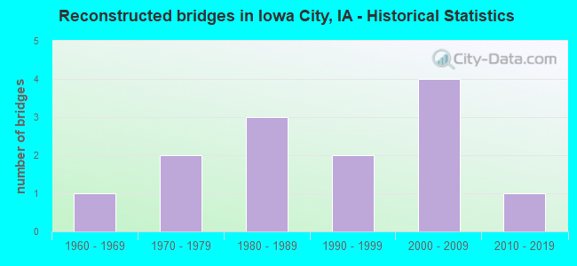
- Reconstructed bridges - Historical Statistics
- 11960-1969
- 21970-1979
- 31980-1989
- 21990-1999
- 42000-2009
- 12010-2019
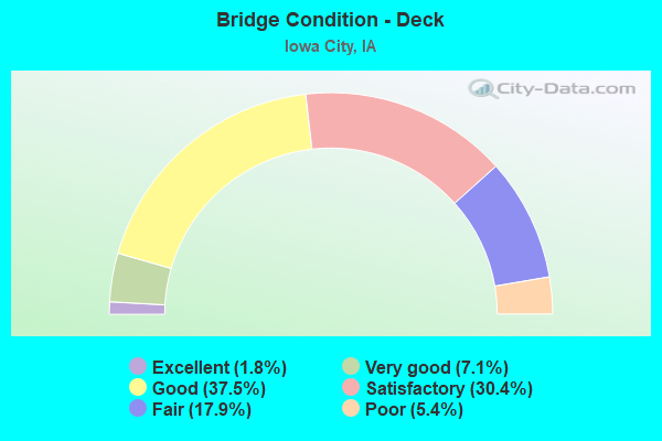
- Bridge Condition - Deck
- 1.8%Excellent
- 7.1%Very good
- 37.5%Good
- 30.4%Satisfactory
- 17.9%Fair
- 5.4%Poor
- Bridge Condition - Superstructure
- 1.8%Excellent
- 17.9%Very good
- 37.5%Good
- 25.0%Satisfactory
- 12.5%Fair
- 5.4%Poor
- Bridge Condition - Substructure
- 1.8%Excellent
- 16.1%Very good
- 42.9%Good
- 26.8%Satisfactory
- 7.1%Fair
- 3.6%Poor
- 1.8%Serious
- Bridge Condition - Channel
- 7.0%Excellent
- 9.9%Very good
- 42.3%Good
- 32.4%Satisfactory
- 7.0%Fair
- 1.4%Poor
- Bridge Condition - Culverts
- 6.3%Excellent
- 6.3%Very good
- 34.4%Good
- 31.3%Satisfactory
- 12.5%Fair
- 6.3%Poor
- 3.1%Serious
Find on map >> Show street view
Structure Number: 204021, Location: 079052704 (Lat: 41.616822, Lng: -91.412219), Route carried "on" structure: County highway , Year Built: 1993, Status: Open, Structure Length: 4.45m (14.60ft), Average Daily Traffic: 820 (year 2018), Average Future Daily Traffic: 820 (year 2041), Design Load: HS 20, Features Intersected: IAIS RR, Facility Carried by Structure: FM
Minimum Vertical Clearance: 30+ m (98+ ft), Kilometerpoint: 1.452, Lanes on structure: 2, Owner: County Highway Agency, Approaching Roadway Width: 8.2m (26.9ft), Skew: 2 degrees, Material/Design: Prestressed concrete, Design/Construction: Stringer/Multi-beam, Number Of Spans In Main Unit: 3, Length of Maximum Span: 14.6m (47.9ft), Curb-To-Curb Width: 9.1m (29.9ft), Out-to-Out Width: 10.1m (33.1ft)
Condition: Deck: Good, Superstructure: Very good, Substructure: Very good, Operating Rating: 76.0 metric tons, Method Used To Determine Operating Rating: Load Factor (LF), Inventory Rating: 35.6 metric tons, Method Used To Determine Inventory Rating: Load Factor (LF), Structural Evaluation: Equal to present desirable criteria, Deck Geometry: Equal to present minimum criteria, Underclear: Meets minimum limits, Approach Roadway Alignment: Equal to present desirable criteria, Designated Inspection Frequency: Every 48 months, Inspection Date: April 2021, Deck Structure Type: Concrete Cast-file-Place, Wearing Surface/Protective System: Wearing Surface: Monolithic Concrete
Find on map >> Show street view
Structure Number: 204033, Location: 079052901 (Lat: 41.627567, Lng: -91.458028), Route carried "on" structure: County highway , Year Built: 1977, Status: Open, Structure Length: 2.38m (7.81ft), Average Daily Traffic: 130 (year 2018), Average Future Daily Traffic: 130 (year 2041), Design Load: HS 20, Features Intersected: SNYDER CR, Facility Carried by Structure: FM
Minimum Vertical Clearance: 30+ m (98+ ft), Kilometerpoint: 1.466, Lanes on structure: 2, Owner: County Highway Agency, Approaching Roadway Width: 6.4m (21.0ft), Material/Design: Concrete continuous, Design/Construction: Slab, Number Of Spans In Main Unit: 3, Length of Maximum Span: 8.8m (28.9ft), Curb-To-Curb Width: 8.5m (27.9ft), Out-to-Out Width: 9.3m (30.5ft)
Condition: Deck: Satisfactory, Superstructure: Satisfactory, Substructure: Good, Channel: Satisfactory, Operating Rating: 46.2 metric tons, Method Used To Determine Operating Rating: Allowable Stress (AS), Inventory Rating: 28.8 metric tons, Method Used To Determine Inventory Rating: Allowable Stress (AS), Structural Evaluation: Equal to present minimum criteria, Deck Geometry: Equal to present minimum criteria, Waterway Adequacy: Better than present minimum criteria, Approach Roadway Alignment: Equal to present desirable criteria, Designated Inspection Frequency: Every 24 months, Inspection Date: April 2021, Deck Structure Type: Concrete Cast-file-Place, Wearing Surface/Protective System: Wearing Surface: Monolithic Concrete
Find on map >> Show street view
Structure Number: 20405, Location: 079053202 (Lat: 41.610617, Lng: -91.463292), Route carried "on" structure: County highway , Year Built: 1966, Status: Open, Structure Length: 1.77m (5.81ft), Average Daily Traffic: 720 (year 2018), Truck Traffic: 8%, Average Future Daily Traffic: 720 (year 2041), Design Load: HS 20, Features Intersected: STREAM, Facility Carried by Structure: TAFT AVE
Minimum Vertical Clearance: 30+ m (98+ ft), Kilometerpoint: 11.096, Lanes on structure: 2, Owner: County Highway Agency, Approaching Roadway Width: 7.0m (23.0ft), Material/Design: Prestressed concrete, Design/Construction: Stringer/Multi-beam, Number Of Spans In Main Unit: 1, Length of Maximum Span: 17.7m (58.1ft), Curb-To-Curb Width: 8.5m (27.9ft), Out-to-Out Width: 9.3m (30.5ft)
Condition: Deck: Fair, Superstructure: Good, Substructure: Satisfactory, Channel: Satisfactory, Operating Rating: 42.0 metric tons, Method Used To Determine Operating Rating: Allowable Stress (AS), Inventory Rating: 24.5 metric tons, Method Used To Determine Inventory Rating: Allowable Stress (AS), Structural Evaluation: Equal to present minimum criteria, Deck Geometry: Somewhat better than minimum adequacy, Waterway Adequacy: Better than present minimum criteria, Approach Roadway Alignment: Equal to present desirable criteria, Designated Inspection Frequency: Every 24 months, Inspection Date: April 2021, Deck Structure Type: Concrete Cast-file-Place, Wearing Surface/Protective System: Wearing Surface: Monolithic Concrete
Find on map >> Show street view
Structure Number: 204085, Location: 079063502 (Lat: 41.609503, Lng: -91.521392), Route carried "on" structure: County highway , Year Built: 1976, Year Reconstructed: 2005, Status: Open, Structure Length: 0.70m (2.30ft), Average Daily Traffic: 3,330 (year 2018), Average Future Daily Traffic: 3,330 (year 2041), Design Load: HL 93, Features Intersected: STREAM, Facility Carried by Structure: FM SAND RD
Minimum Vertical Clearance: 30+ m (98+ ft), Kilometerpoint: 13.607, Lanes on structure: 2, Owner: County Highway Agency, Approaching Roadway Width: 7.0m (23.0ft), Material/Design: Concrete continuous, Design/Construction: Culvert, Number Of Spans In Main Unit: 2, Length of Maximum Span: 3.0m (9.8ft)
Condition: Channel: Fair, Culverts: Satisfactory, Operating Rating: 46.7 metric tons, Method Used To Determine Operating Rating: Load and Resistance Factor Rating (LRFR) rating reported by rating factor(RF) method using HL-93 loadings, Inventory Rating: 36.0 metric tons, Method Used To Determine Inventory Rating: Load and Resistance Factor Rating (LRFR) rating reported by rating factor(RF) method using HL-93 loadings, Structural Evaluation: Equal to present minimum criteria, Waterway Adequacy: Better than present minimum criteria, Approach Roadway Alignment: Equal to present minimum criteria, Designated Inspection Frequency: Every 24 months, Inspection Date: April 2021
Find on map >> Show street view
Structure Number: 204185, Location: 079072303 (Lat: 41.634142, Lng: -91.622794), Route carried "on" structure: County highway , Year Built: 1900, Status: Open, Structure Length: 0.82m (2.69ft), Average Daily Traffic: 250 (year 2018), Average Future Daily Traffic: 250 (year 2041), Design Load: HL 93, Features Intersected: DRAINAGE, Facility Carried by Structure: FM ROHRET RD
Minimum Vertical Clearance: 30+ m (98+ ft), Kilometerpoint: 17.693, Lanes on structure: 2, Owner: County Highway Agency, Approaching Roadway Width: 7.0m (23.0ft), Material/Design: Concrete continuous, Design/Construction: Culvert, Number Of Spans In Main Unit: 2, Length of Maximum Span: 3.7m (12.1ft)
Condition: Channel: Fair, Culverts: Satisfactory, Operating Rating: 46.7 metric tons, Method Used To Determine Operating Rating: Load and Resistance Factor Rating (LRFR) rating reported by rating factor(RF) method using HL-93 loadings, Inventory Rating: 36.0 metric tons, Method Used To Determine Inventory Rating: Load and Resistance Factor Rating (LRFR) rating reported by rating factor(RF) method using HL-93 loadings, Structural Evaluation: Equal to present minimum criteria, Waterway Adequacy: Equal to present desirable criteria, Approach Roadway Alignment: Equal to present minimum criteria, Length Of Structure Improvement: 4.00m (13.12ft), Designated Inspection Frequency: Every 24 months, Inspection Date: May 2021, Bridge Improvement Cost: $66,000, Roadway Improvement Cost: $19,000
Find on map >> Show street view
Structure Number: 204191, Location: 079072705 (Lat: 41.618531, Lng: -91.653644), Route carried "on" structure: County highway , Year Built: 2006, Status: Open, Structure Length: 1.86m (6.10ft), Average Daily Traffic: 810 (year 2018), Average Future Daily Traffic: 810 (year 2041), Design Load: HS 20, Features Intersected: OLD WOMAN'S CREEK, Facility Carried by Structure: SW BLK DIAMOND
Minimum Vertical Clearance: 30+ m (98+ ft), Kilometerpoint: 16.007, Lanes on structure: 2, Owner: County Highway Agency, Approaching Roadway Width: 9.8m (32.2ft), Material/Design: Prestressed concrete, Design/Construction: Stringer/Multi-beam, Number Of Spans In Main Unit: 1, Length of Maximum Span: 18.6m (61.0ft), Curb-To-Curb Width: 9.3m (30.5ft), Out-to-Out Width: 9.3m (30.5ft)
Condition: Deck: Good, Superstructure: Very good, Substructure: Satisfactory, Channel: Good, Operating Rating: 56.1 metric tons, Method Used To Determine Operating Rating: Load and Resistance Factor Rating (LRFR) rating reported by rating factor(RF) method using HL-93 loadings, Inventory Rating: 43.4 metric tons, Method Used To Determine Inventory Rating: Load and Resistance Factor Rating (LRFR) rating reported by rating factor(RF) method using HL-93 loadings, Structural Evaluation: Equal to present minimum criteria, Deck Geometry: Equal to present minimum criteria, Waterway Adequacy: Equal to present desirable criteria, Approach Roadway Alignment: Equal to present desirable criteria, Designated Inspection Frequency: Every 24 months, Inspection Date: May 2021, Deck Structure Type: Concrete Cast-file-Place, Wearing Surface/Protective System: Wearing Surface: Monolithic Concrete
Find on map >> Show street view
Structure Number: 204201, Location: 079072801 (Lat: 41.628728, Lng: -91.663333), Route carried "on" structure: County highway , Year Built: 2004, Status: Open, Structure Length: 0.73m (2.40ft), Average Daily Traffic: 60 (year 2018), Average Future Daily Traffic: 60 (year 2041), Design Load: HL 93, Features Intersected: OLD WOMENS CR, Facility Carried by Structure: FM ROHRET RD
Minimum Vertical Clearance: 30+ m (98+ ft), Kilometerpoint: 14.143, Lanes on structure: 2, Owner: County Highway Agency, Approaching Roadway Width: 8.5m (27.9ft), Skew: 3 degrees, Material/Design: Concrete continuous, Design/Construction: Culvert, Number Of Spans In Main Unit: 2, Length of Maximum Span: 3.7m (12.1ft)
Condition: Channel: Good, Culverts: Good, Operating Rating: 46.7 metric tons, Method Used To Determine Operating Rating: Load and Resistance Factor Rating (LRFR) rating reported by rating factor(RF) method using HL-93 loadings, Inventory Rating: 36.0 metric tons, Method Used To Determine Inventory Rating: Load and Resistance Factor Rating (LRFR) rating reported by rating factor(RF) method using HL-93 loadings, Structural Evaluation: Better than present minimum criteria, Waterway Adequacy: Equal to present desirable criteria, Approach Roadway Alignment: Equal to present desirable criteria, Designated Inspection Frequency: Every 48 months, Inspection Date: May 2021
Find on map >> Show street view
Structure Number: 204241, Location: 079073502 (Lat: 41.608244, Lng: -91.638508), Route carried "on" structure: County highway , Year Built: 2000, Status: Open, Structure Length: 5.64m (18.50ft), Average Daily Traffic: 30 (year 2018), Truck Traffic: 17%, Average Future Daily Traffic: 30 (year 2041), Design Load: HS 20, Features Intersected: OLD MANS CREEK, Facility Carried by Structure: SW KANSAS AVE
Minimum Vertical Clearance: 30+ m (98+ ft), Kilometerpoint: 11.175, Lanes on structure: 2, Owner: County Highway Agency, Approaching Roadway Width: 7.6m (24.9ft), Material/Design: Prestressed concrete, Design/Construction: Stringer/Multi-beam, Number Of Spans In Main Unit: 3, Length of Maximum Span: 21.0m (68.9ft), Curb-To-Curb Width: 7.6m (24.9ft), Out-to-Out Width: 8.2m (26.9ft)
Condition: Deck: Good, Superstructure: Good, Substructure: Good, Channel: Good, Operating Rating: 80.0 metric tons, Method Used To Determine Operating Rating: Load Factor (LF), Inventory Rating: 36.2 metric tons, Method Used To Determine Inventory Rating: Load Factor (LF), Structural Evaluation: Better than present minimum criteria, Deck Geometry: Equal to present minimum criteria, Waterway Adequacy: Equal to present desirable criteria, Approach Roadway Alignment: Equal to present desirable criteria, Designated Inspection Frequency: Every 48 months, Inspection Date: May 2021, Deck Structure Type: Concrete Cast-file-Place
Find on map >> Show street view
Structure Number: 204251, Location: 0790736 (Lat: 41.606381, Lng: -91.615778), Route carried "on" structure: County highway , Year Built: 2014, Status: Open, Structure Length: 6.14m (20.14ft), Average Daily Traffic: 610 (year 2018), Truck Traffic: 14%, Average Future Daily Traffic: 610 (year 2041), Design Load: HL 93, Features Intersected: OLD MANS CREEK, Facility Carried by Structure: W 62
Minimum Vertical Clearance: 30+ m (98+ ft), Kilometerpoint: 12.725, Lanes on structure: 2, Owner: County Highway Agency, Approaching Roadway Width: 9.8m (32.2ft), Material/Design: Prestressed concrete, Design/Construction: Stringer/Multi-beam, Number Of Spans In Main Unit: 3, Length of Maximum Span: 22.3m (73.2ft), Curb-To-Curb Width: 9.3m (30.5ft), Out-to-Out Width: 10.1m (33.1ft)
Condition: Deck: Good, Superstructure: Very good, Substructure: Very good, Channel: Very good, Operating Rating: 79.6 metric tons, Method Used To Determine Operating Rating: Load Factor (LF), Inventory Rating: 41.2 metric tons, Method Used To Determine Inventory Rating: Load Factor (LF), Structural Evaluation: Equal to present desirable criteria, Deck Geometry: Equal to present minimum criteria, Waterway Adequacy: Equal to present desirable criteria, Approach Roadway Alignment: Equal to present desirable criteria, Designated Inspection Frequency: Every 48 months, Inspection Date: April 2021, Deck Structure Type: Concrete Cast-file-Place, Wearing Surface/Protective System: Deck Protection: Epoxy Coated Reinforcing
Find on map >> Show street view
Structure Number: 20468, Location: 080052005 (Lat: 41.719022, Lng: -91.455936), Route carried "on" structure: County highway , Year Built: 1960, Status: Posted for load, Structure Length: 1.22m (4.00ft), Average Daily Traffic: 390 (year 2018), Average Future Daily Traffic: 390 (year 2041), Design Load: HS 20, Features Intersected: RAPID CR, Facility Carried by Structure: DINGLEBERRY RD
Minimum Vertical Clearance: 30+ m (98+ ft), Kilometerpoint: 2.017, Lanes on structure: 1, Owner: County Highway Agency, Approaching Roadway Width: 7.3m (24.0ft), Material/Design: Steel, Design/Construction: Stringer/Multi-beam, Number Of Spans In Main Unit: 1, Length of Maximum Span: 12.2m (40.0ft), Curb-To-Curb Width: 5.4m (17.7ft), Out-to-Out Width: 5.5m (18.0ft)
Condition: Deck: Fair, Superstructure: Poor, Substructure: Serious, Channel: Satisfactory, Operating Rating: 17.2 metric tons, Method Used To Determine Operating Rating: Allowable Stress (AS), Inventory Rating: 9.1 metric tons, Method Used To Determine Inventory Rating: Allowable Stress (AS), Structural Evaluation: High priority of replacement, Deck Geometry: High priority of replacement, Waterway Adequacy: Equal to present desirable criteria, Approach Roadway Alignment: Meets minimum limits, Bridge Posting: Required (Relationship of Operating Rating to Maximum Legal Load: 10.0 - 19.9% below), Length Of Structure Improvement: 5.00m (16.40ft), Designated Inspection Frequency: Every 24 months, Inspection Date: April 2021, Bridge Improvement Cost: $65,000, Roadway Improvement Cost: $25,000, Deck Structure Type: Concrete Cast-file-Place, Wearing Surface/Protective System: Wearing Surface: Monolithic Concrete
Find on map >> Show street view
Structure Number: 20472, Location: 080052106 (Lat: 41.722956, Lng: -91.438622), Route carried "on" structure: County highway , Year Built: 1965, Status: Open, Structure Length: 2.38m (7.81ft), Average Daily Traffic: 100 (year 2018), Truck Traffic: 14%, Average Future Daily Traffic: 100 (year 2041), Design Load: HS 20, Features Intersected: STREAM, Facility Carried by Structure: WAPSIE RD
Minimum Vertical Clearance: 30+ m (98+ ft), Kilometerpoint: 26.142, Lanes on structure: 2, Owner: County Highway Agency, Approaching Roadway Width: 9.1m (29.9ft), Skew: 3 degrees, Material/Design: Concrete continuous, Design/Construction: Slab, Number Of Spans In Main Unit: 3, Length of Maximum Span: 8.8m (28.9ft), Curb-To-Curb Width: 8.5m (27.9ft), Out-to-Out Width: 9.3m (30.5ft)
Condition: Deck: Fair, Superstructure: Fair, Substructure: Fair, Channel: Good, Operating Rating: 32.3 metric tons, Method Used To Determine Operating Rating: Allowable Stress (AS), Inventory Rating: 22.5 metric tons, Method Used To Determine Inventory Rating: Allowable Stress (AS), Structural Evaluation: Somewhat better than minimum adequacy, Deck Geometry: Better than present minimum criteria, Waterway Adequacy: Better than present minimum criteria, Approach Roadway Alignment: Equal to present minimum criteria, Designated Inspection Frequency: Every 24 months, Inspection Date: April 2021, Deck Structure Type: Concrete Cast-file-Place, Wearing Surface/Protective System: Wearing Surface: Monolithic Concrete
Find on map >> Show street view
Structure Number: 204821, Location: T80N, R5W, 29 (Lat: 41.709256, Lng: -91.453956), Route carried "on" structure: County highway , Year Built: 2019, Status: Open, Structure Length: 1.77m (5.81ft), Average Daily Traffic: 490 (year 2018), Average Future Daily Traffic: 490 (year 2040), Design Load: HL 93, Features Intersected: BR RAPID CR, Facility Carried by Structure: RAPID CREEK RD
Minimum Vertical Clearance: 30+ m (98+ ft), Kilometerpoint: 3.666, Lanes on structure: 2, Owner: County Highway Agency, Approaching Roadway Width: 9.8m (32.2ft), Material/Design: Prestressed concrete, Design/Construction: Stringer/Multi-beam, Number Of Spans In Main Unit: 1, Length of Maximum Span: 16.8m (55.1ft), Curb-To-Curb Width: 9.3m (30.5ft), Out-to-Out Width: 10.1m (33.1ft)
Condition: Deck: Very good, Superstructure: Very good, Substructure: Very good, Channel: Very good, Operating Rating: 60.6 metric tons, Method Used To Determine Operating Rating: Load and Resistance Factor Rating (LRFR) rating reported by rating factor(RF) method using HL-93 loadings, Inventory Rating: 46.7 metric tons, Method Used To Determine Inventory Rating: Load and Resistance Factor Rating (LRFR) rating reported by rating factor(RF) method using HL-93 loadings, Structural Evaluation: Equal to present desirable criteria, Deck Geometry: Equal to present minimum criteria, Waterway Adequacy: Equal to present desirable criteria, Approach Roadway Alignment: Equal to present desirable criteria, Designated Inspection Frequency: Every 24 months, Inspection Date: July 2020, Deck Structure Type: Concrete Cast-file-Place, Wearing Surface/Protective System: Wearing Surface: Monolithic Concrete, Deck Protection: Epoxy Coated Reinforcing
Find on map >> Show street view
Structure Number: 20483, Location: 080053103 (Lat: 41.698606, Lng: -91.477808), Route carried "on" structure: County highway , Year Built: 1950, Status: Posted for load, Structure Length: 1.34m (4.40ft), Average Daily Traffic: 490 (year 2018), Average Future Daily Traffic: 490 (year 2041), Design Load: HS 20, Features Intersected: BR RAPID CR, Facility Carried by Structure: RAPID CK RD
Minimum Vertical Clearance: 30+ m (98+ ft), Kilometerpoint: 1.109, Lanes on structure: 2, Owner: County Highway Agency, Approaching Roadway Width: 8.2m (26.9ft), Skew: 4 degrees, Material/Design: Steel, Design/Construction: Stringer/Multi-beam, Number Of Spans In Main Unit: 1, Length of Maximum Span: 13.4m (44.0ft), Curb-To-Curb Width: 7.3m (24.0ft), Out-to-Out Width: 7.8m (25.6ft)
Condition: Deck: Satisfactory, Superstructure: Satisfactory, Substructure: Poor, Channel: Fair, Operating Rating: 24.2 metric tons, Method Used To Determine Operating Rating: Allowable Stress (AS), Inventory Rating: 14.3 metric tons, Method Used To Determine Inventory Rating: Allowable Stress (AS), Structural Evaluation: Meets minimum limits, Deck Geometry: Meets minimum limits, Waterway Adequacy: Equal to present minimum criteria, Approach Roadway Alignment: Meets minimum limits, Bridge Posting: Required (Relationship of Operating Rating to Maximum Legal Load: 0.1 - 9.9% below), Length Of Structure Improvement: 6.00m (19.69ft), Designated Inspection Frequency: Every 24 months, Inspection Date: April 2021, Bridge Improvement Cost: $100,000, Roadway Improvement Cost: $60,000, Deck Structure Type: Concrete Cast-file-Place, Wearing Surface/Protective System: Wearing Surface: Bituminous
Find on map >> Show street view
Structure Number: 204911, Location: 080062604 (Lat: 41.713925, Lng: -91.517347), Route carried "on" structure: County highway , Year Built: 1993, Status: Open, Structure Length: 0.70m (2.30ft), Average Daily Traffic: 980 (year 2018), Average Future Daily Traffic: 980 (year 2041), Design Load: HL 93, Features Intersected: BR RAPID CREEK, Facility Carried by Structure: FM PRARE DU CHN
Minimum Vertical Clearance: 30+ m (98+ ft), Kilometerpoint: 3.182, Lanes on structure: 2, Owner: County Highway Agency, Approaching Roadway Width: 7.0m (23.0ft), Skew: 3 degrees, Material/Design: Concrete continuous, Design/Construction: Culvert, Number Of Spans In Main Unit: 2, Length of Maximum Span: 3.0m (9.8ft)
Condition: Channel: Satisfactory, Culverts: Satisfactory, Operating Rating: 46.7 metric tons, Method Used To Determine Operating Rating: Load and Resistance Factor Rating (LRFR) rating reported by rating factor(RF) method using HL-93 loadings, Inventory Rating: 36.0 metric tons, Method Used To Determine Inventory Rating: Load and Resistance Factor Rating (LRFR) rating reported by rating factor(RF) method using HL-93 loadings, Structural Evaluation: Equal to present minimum criteria, Waterway Adequacy: Equal to present desirable criteria, Approach Roadway Alignment: Equal to present desirable criteria, Designated Inspection Frequency: Every 48 months, Inspection Date: April 2021
Find on map >> Show street view
Structure Number: 204921, Location: 080062608 (Lat: 41.709858, Lng: -91.507339), Route carried "on" structure: County highway , Year Built: 1976, Status: Open, Structure Length: 0.70m (2.30ft), Average Daily Traffic: 1,060 (year 2018), Truck Traffic: 5%, Average Future Daily Traffic: 1,060 (year 2041), Design Load: HL 93, Features Intersected: BR TURKEY CR, Facility Carried by Structure: NEWPORT RD
Minimum Vertical Clearance: 30+ m (98+ ft), Kilometerpoint: 1.059, Lanes on structure: 2, Owner: County Highway Agency, Approaching Roadway Width: 7.0m (23.0ft), Material/Design: Concrete continuous, Design/Construction: Culvert, Number Of Spans In Main Unit: 2, Length of Maximum Span: 3.0m (9.8ft)
Condition: Channel: Satisfactory, Culverts: Satisfactory, Operating Rating: 46.7 metric tons, Method Used To Determine Operating Rating: Load and Resistance Factor Rating (LRFR) rating reported by rating factor(RF) method using HL-93 loadings, Inventory Rating: 36.0 metric tons, Method Used To Determine Inventory Rating: Load and Resistance Factor Rating (LRFR) rating reported by rating factor(RF) method using HL-93 loadings, Structural Evaluation: Equal to present minimum criteria, Waterway Adequacy: Better than present minimum criteria, Approach Roadway Alignment: Equal to present minimum criteria, Length Of Structure Improvement: 3.00m (9.84ft), Designated Inspection Frequency: Every 48 months, Inspection Date: April 2021, Bridge Improvement Cost: $50,000, Roadway Improvement Cost: $15,000
Find on map >> Show street view
Structure Number: 204951, Location: 080063318 (Lat: 41.693311, Lng: -91.547208), Route carried "on" structure: County highway , Year Built: 1991, Status: Open, Structure Length: 13.59m (44.59ft), Average Daily Traffic: 6,900 (year 2018), Average Future Daily Traffic: 6,900 (year 2041), Design Load: HL 93, Features Intersected: IOWA RIVER, Facility Carried by Structure: DUBUQUE ST
Minimum Vertical Clearance: 30+ m (98+ ft), Kilometerpoint: 0.982, Lanes on structure: 2, Owner: County Highway Agency, Approaching Roadway Width: 9.8m (32.2ft), Material/Design: Prestressed concrete, Design/Construction: Stringer/Multi-beam, Number Of Spans In Main Unit: 5, Length of Maximum Span: 29.3m (96.1ft), Curb-To-Curb Width: 12.2m (40.0ft), Out-to-Out Width: 12.8m (42.0ft)
Condition: Deck: Satisfactory, Superstructure: Good, Substructure: Good, Channel: Good, Operating Rating: 97.2 metric tons, Method Used To Determine Operating Rating: Load and Resistance Factor Rating (LRFR) rating reported by rating factor(RF) method using HL-93 loadings, Inventory Rating: 76.1 metric tons, Method Used To Determine Inventory Rating: Load and Resistance Factor Rating (LRFR) rating reported by rating factor(RF) method using HL-93 loadings, Structural Evaluation: Better than present minimum criteria, Deck Geometry: Somewhat better than minimum adequacy, Waterway Adequacy: Equal to present desirable criteria, Approach Roadway Alignment: Equal to present desirable criteria, Designated Inspection Frequency: Every 48 months, Inspection Date: April 2021, Deck Structure Type: Concrete Cast-file-Place
Find on map >> Show street view
Structure Number: 204961, Location: 080063504 (Lat: 41.698225, Lng: -91.520900), Route carried "on" structure: County highway , Year Built: 1975, Status: Open, Structure Length: 4.69m (15.39ft), Average Daily Traffic: 1,970 (year 2018), Average Future Daily Traffic: 1,970 (year 2041), Design Load: HS 20, Features Intersected: RAPID CREEK, Facility Carried by Structure: FM PRARE DU CHN
Minimum Vertical Clearance: 30+ m (98+ ft), Kilometerpoint: 1.308, Lanes on structure: 2, Owner: County Highway Agency, Approaching Roadway Width: 6.1m (20.0ft), Material/Design: Prestressed concrete, Design/Construction: Stringer/Multi-beam, Number Of Spans In Main Unit: 3, Length of Maximum Span: 17.1m (56.1ft), Curb-To-Curb Width: 9.1m (29.9ft), Out-to-Out Width: 9.1m (29.9ft)
Condition: Deck: Satisfactory, Superstructure: Satisfactory, Substructure: Good, Channel: Satisfactory, Operating Rating: 69.0 metric tons, Method Used To Determine Operating Rating: Allowable Stress (AS), Inventory Rating: 32.8 metric tons, Method Used To Determine Inventory Rating: Allowable Stress (AS), Structural Evaluation: Equal to present minimum criteria, Deck Geometry: Somewhat better than minimum adequacy, Waterway Adequacy: Equal to present desirable criteria, Approach Roadway Alignment: Equal to present desirable criteria, Designated Inspection Frequency: Every 48 months, Inspection Date: April 2021, Deck Structure Type: Concrete Cast-file-Place, Wearing Surface/Protective System: Wearing Surface: Monolithic Concrete
Find on map >> Show street view
Structure Number: 36479, Location: 000000000 (Lat: 41.631775, Lng: -91.548806), Route carried "on" structure: City street , Year Built: 2005, Status: Open, Structure Length: 1.31m (4.30ft), Average Daily Traffic: 5,200 (year 2018), Average Future Daily Traffic: 5,200 (year 2041), Design Load: HS 20, Features Intersected: WILLOW CREEK, Facility Carried by Structure: MORMAN TREK BLV
Minimum Vertical Clearance: 30+ m (98+ ft), Kilometerpoint: 0.686, Lanes on structure: 3, Owner: City or Municipal Highway Agency, Approaching Roadway Width: 12.2m (40.0ft), Skew: 3 degrees, Material/Design: Concrete continuous, Design/Construction: Culvert, Number Of Spans In Main Unit: 3, Length of Maximum Span: 4.3m (14.1ft)
Condition: Channel: Good, Culverts: Good, Operating Rating: 44.1 metric tons, Method Used To Determine Operating Rating: Field evaluation and documented engineering judgment, Inventory Rating: 32.7 metric tons, Method Used To Determine Inventory Rating: Field evaluation and documented engineering judgment, Structural Evaluation: Better than present minimum criteria, Waterway Adequacy: Equal to present desirable criteria, Approach Roadway Alignment: Equal to present desirable criteria, Length Of Structure Improvement: 4.30m (14.11ft), Designated Inspection Frequency: Every 24 months, Inspection Date: June 2021, Bridge Improvement Cost: $15,000, Roadway Improvement Cost: $2,000
Find on map >> Show street view
Structure Number: 50078, Location: 000000000 (Lat: 41.656742, Lng: -91.514881), Route carried "on" structure: City street , Year Built: 1979, Status: Open, Structure Length: 1.31m (4.30ft), Average Daily Traffic: 7,500 (year 2014), Average Future Daily Traffic: 7,500 (year 2041), Features Intersected: RALSTON CREEK, Facility Carried by Structure: MUSCATINE AVE
Minimum Vertical Clearance: 30+ m (98+ ft), Kilometerpoint: 3.159, Lanes on structure: 4, Owner: City or Municipal Highway Agency, Approaching Roadway Width: 9.1m (29.9ft), Skew: 4 degrees, Material/Design: Concrete continuous, Design/Construction: Culvert, Number Of Spans In Main Unit: 3, Length of Maximum Span: 4.3m (14.1ft)
Condition: Channel: Satisfactory, Culverts: Satisfactory, Operating Rating: 38.0 metric tons, Method Used To Determine Operating Rating: Load Factor (LF), Inventory Rating: 22.8 metric tons, Method Used To Determine Inventory Rating: Load Factor (LF), Structural Evaluation: Somewhat better than minimum adequacy, Waterway Adequacy: Equal to present minimum criteria, Approach Roadway Alignment: Better than present minimum criteria, Length Of Structure Improvement: 4.30m (14.11ft), Designated Inspection Frequency: Every 24 months, Inspection Date: June 2021, Bridge Improvement Cost: $15,000, Roadway Improvement Cost: $2,000
Find on map >> Show street view
Structure Number: 500791, Location: 00000000 (Lat: 41.654394, Lng: -91.531681), Route carried "on" structure: City street , Year Built: 2020, Status: Open, Structure Length: 1.23m (4.04ft), Average Daily Traffic: 1,768 (year 1975), Average Future Daily Traffic: 1,768 (year 2041), Design Load: HL 93, Features Intersected: RALSTON CREEK, Facility Carried by Structure: PRENTISS ST
Minimum Vertical Clearance: 30+ m (98+ ft), Kilometerpoint: 0.571, Lanes on structure: 2, Owner: City or Municipal Highway Agency, Approaching Roadway Width: 9.4m (30.8ft), Skew: 1 degrees, Material/Design: Concrete continuous, Design/Construction: Culvert, Number Of Spans In Main Unit: 3, Length of Maximum Span: 4.0m (13.1ft), Curb or Sidewalk Widths: Left: 0.3m (1.0ft), Right: 3.8m (12.5ft), Curb-To-Curb Width: 19.6m (64.3ft), Out-to-Out Width: 20.2m (66.3ft)
Condition: Channel: Good, Culverts: Excellent, Operating Rating: 42.1 metric tons, Method Used To Determine Operating Rating: Assigned ratings based on Load and Resistance Factor Design (LRFD) reported by rating factor (RF) using HL93 loadings, Inventory Rating: 32.4 metric tons, Method Used To Determine Inventory Rating: Assigned ratings based on Load and Resistance Factor Design (LRFD) reported by rating factor (RF) using HL93 loadings, Structural Evaluation: Equal to present desirable criteria, Deck Geometry: Superior to present desirable criteria, Waterway Adequacy: Better than present minimum criteria, Approach Roadway Alignment: Better than present minimum criteria, Designated Inspection Frequency: Every 24 months, Inspection Date: June 2021
Find on map >> Show street view
Structure Number: 5008, Location: 000000000 (Lat: 41.658939, Lng: -91.529319), Route carried "on" structure: City street , Year Built: 1971, Status: Open, Structure Length: 5.52m (18.11ft), Average Daily Traffic: 2,060 (year 1982), Average Future Daily Traffic: 2,060 (year 2041), Design Load: HS 20, Features Intersected: RALSTON CREEK, Facility Carried by Structure: COLLEGE ST
Minimum Vertical Clearance: 30+ m (98+ ft), Kilometerpoint: 0.195, Lanes on structure: 4, Owner: City or Municipal Highway Agency, Approaching Roadway Width: 14.6m (47.9ft), Material/Design: Concrete, Design/Construction: Frame, Number Of Spans In Main Unit: 1, Length of Maximum Span: 45.7m (149.9ft), Curb or Sidewalk Widths: Left: 2.1m (6.9ft), Right: 2.1m (6.9ft), Curb-To-Curb Width: 14.6m (47.9ft), Out-to-Out Width: 19.5m (64.0ft)
Condition: Deck: Fair, Superstructure: Fair, Substructure: Good, Channel: Good, Operating Rating: 27.9 metric tons, Method Used To Determine Operating Rating: Load and Resistance Factor Rating (LRFR) rating reported by rating factor(RF) method using HL-93 loadings, Inventory Rating: 21.7 metric tons, Method Used To Determine Inventory Rating: Load and Resistance Factor Rating (LRFR) rating reported by rating factor(RF) method using HL-93 loadings, Structural Evaluation: Somewhat better than minimum adequacy, Deck Geometry: High priority of replacement, Waterway Adequacy: Superior to present desirable criteria, Approach Roadway Alignment: Better than present minimum criteria, Length Of Structure Improvement: 18.10m (59.38ft), Designated Inspection Frequency: Every 24 months, Inspection Date: June 2021, Bridge Improvement Cost: $15,000, Roadway Improvement Cost: $2,000, Deck Structure Type: Concrete Cast-file-Place, Wearing Surface/Protective System: Wearing Surface: Monolithic Concrete
Find on map >> Show street view
Structure Number: 50081, Location: 000000000 (Lat: 41.660019, Lng: -91.528419), Route carried "on" structure: City street , Year Built: 1910, Year Reconstructed: 1980, Status: Open, Structure Length: 1.04m (3.41ft), Average Daily Traffic: 2,810 (year 1994), Average Future Daily Traffic: 2,810 (year 2041), Design Load: H 20, Features Intersected: RALSTON CREEK, Facility Carried by Structure: WASHINGTON ST
Minimum Vertical Clearance: 30+ m (98+ ft), Kilometerpoint: 0.779, Lanes on structure: 4, Owner: City or Municipal Highway Agency, Approaching Roadway Width: 18.3m (60.0ft), Skew: 4 degrees, Material/Design: Concrete, Design/Construction: Slab, Number Of Spans In Main Unit: 1, Length of Maximum Span: 9.4m (30.8ft), Curb or Sidewalk Widths: Left: 3.0m (9.8ft), Right: 0.0m, Curb-To-Curb Width: 19.5m (64.0ft), Out-to-Out Width: 23.8m (78.1ft)
Condition: Deck: Satisfactory, Superstructure: Satisfactory, Substructure: Poor, Channel: Satisfactory, Operating Rating: 38.1 metric tons, Method Used To Determine Operating Rating: Load Factor (LF), Inventory Rating: 22.9 metric tons, Method Used To Determine Inventory Rating: Load Factor (LF), Structural Evaluation: Meets minimum limits, Deck Geometry: Better than present minimum criteria, Waterway Adequacy: Equal to present minimum criteria, Approach Roadway Alignment: Equal to present minimum criteria, Length Of Structure Improvement: 3.40m (11.15ft), Designated Inspection Frequency: Every 24 months, Inspection Date: June 2021, Bridge Improvement Cost: $15,000, Roadway Improvement Cost: $2,000, Deck Structure Type: Concrete Cast-file-Place, Wearing Surface/Protective System: Wearing Surface: Monolithic Concrete, Deck Protection: Epoxy Coated Reinforcing
Find on map >> Show street view
Structure Number: 50082, Location: 000000000 (Lat: 41.660939, Lng: -91.524283), Route carried "on" structure: City street , Year Built: 1910, Year Reconstructed: 1960, Status: Open, Structure Length: 0.85m (2.79ft), Average Daily Traffic: 800 (year 1975), Average Future Daily Traffic: 800 (year 2041), Features Intersected: RALSTON CREEK, Facility Carried by Structure: IOWA AVE
Minimum Vertical Clearance: 30+ m (98+ ft), Kilometerpoint: 1.201, Lanes on structure: 2, Owner: City or Municipal Highway Agency, Approaching Roadway Width: 14.0m (45.9ft), Skew: 3 degrees, Material/Design: Concrete, Design/Construction: Culvert, Number Of Spans In Main Unit: 1, Length of Maximum Span: 7.6m (24.9ft)
Condition: Channel: Good, Culverts: Poor, Operating Rating: 22.7 metric tons, Method Used To Determine Operating Rating: Field evaluation and documented engineering judgment, Inventory Rating: 17.0 metric tons, Method Used To Determine Inventory Rating: Field evaluation and documented engineering judgment, Structural Evaluation: Meets minimum limits, Waterway Adequacy: Better than present minimum criteria, Approach Roadway Alignment: Equal to present minimum criteria, Length Of Structure Improvement: 2.80m (9.19ft), Designated Inspection Frequency: Every 24 months, Inspection Date: June 2021, Bridge Improvement Cost: $15,000, Roadway Improvement Cost: $2,000
Find on map >> Show street view
Structure Number: 50118, Location: 000000000 (Lat: 41.661253, Lng: -91.541831), Route carried "on" structure: City street , Year Built: 1916, Year Reconstructed: 1985, Status: Open, Structure Length: 9.60m (31.50ft), Average Daily Traffic: 9,100 (year 2018), Average Future Daily Traffic: 9,100 (year 2041), Design Load: HS 20, Features Intersected: IOWA RIVER, Facility Carried by Structure: IOWA AVE
Minimum Vertical Clearance: 30+ m (98+ ft), Kilometerpoint: 0.035, Lanes on structure: 4, Owner: City or Municipal Highway Agency, Approaching Roadway Width: 12.2m (40.0ft), Material/Design: Concrete continuous, Design/Construction: Arch - Deck, Number Of Spans In Main Unit: 3, Length of Maximum Span: 32.0m (105.0ft), Curb or Sidewalk Widths: Left: 2.4m (7.9ft), Right: 3.0m (9.8ft), Curb-To-Curb Width: 14.6m (47.9ft), Out-to-Out Width: 21.3m (69.9ft)
Condition: Deck: Fair, Superstructure: Fair, Substructure: Fair, Channel: Good, Operating Rating: 53.2 metric tons, Method Used To Determine Operating Rating: Load Factor (LF), Inventory Rating: 31.9 metric tons, Method Used To Determine Inventory Rating: Load Factor (LF), Structural Evaluation: Somewhat better than minimum adequacy, Deck Geometry: High priority of replacement, Waterway Adequacy: Better than present minimum criteria, Approach Roadway Alignment: Better than present minimum criteria, Length Of Structure Improvement: 34.80m (114.17ft), Designated Inspection Frequency: Every 24 months, Underwater Inspection Frequency: Every 60 months, Inspection Date: June 2021, Underwater Inspection Date: August 2019, Bridge Improvement Cost: $2,650,000, Roadway Improvement Cost: $265,000, Deck Structure Type: Concrete Cast-file-Place, Wearing Surface/Protective System: Wearing Surface: Monolithic Concrete, Deck Protection: Epoxy Coated Reinforcing
Find on map >> Show street view
Structure Number: 50119, Location: C59900514 (Lat: 41.650553, Lng: -91.574058), Route carried "on" structure: City street , Year Built: 1971, Status: Open, Structure Length: 0.64m (2.10ft), Average Daily Traffic: 13,600 (year 2018), Average Future Daily Traffic: 13,600 (year 2041), Design Load: H 20, Features Intersected: WILLOW CREEK, Facility Carried by Structure: MORMON TRK BLVD
Minimum Vertical Clearance: 30+ m (98+ ft), Kilometerpoint: 2.430, Lanes on structure: 4, Owner: City or Municipal Highway Agency, Approaching Roadway Width: 13.4m (44.0ft), Material/Design: Concrete continuous, Design/Construction: Culvert, Number Of Spans In Main Unit: 2, Length of Maximum Span: 3.0m (9.8ft)
Condition: Channel: Satisfactory, Culverts: Fair, Operating Rating: 52.7 metric tons, Method Used To Determine Operating Rating: Load Factor (LF), Inventory Rating: 31.6 metric tons, Method Used To Determine Inventory Rating: Load Factor (LF), Structural Evaluation: Somewhat better than minimum adequacy, Waterway Adequacy: Better than present minimum criteria, Approach Roadway Alignment: Equal to present desirable criteria, Length Of Structure Improvement: 2.10m (6.89ft), Designated Inspection Frequency: Every 24 months, Inspection Date: June 2021, Bridge Improvement Cost: $15,000, Roadway Improvement Cost: $2,000
Find on map >> Show street view
Structure Number: 5012, Location: 000000000 (Lat: 41.649644, Lng: -91.572461), Route carried "on" structure: Ramp City street , Year Built: 1971, Status: Open, Structure Length: 0.64m (2.10ft), Average Daily Traffic: 6,200 (year 2018), Average Future Daily Traffic: 6,200 (year 2041), Features Intersected: WILLOW CREEK, Facility Carried by Structure: W BENTON ST
Minimum Vertical Clearance: 30+ m (98+ ft), Kilometerpoint: 0.134, Lanes on structure: 2, Owner: City or Municipal Highway Agency, Approaching Roadway Width: 9.8m (32.2ft), Material/Design: Concrete continuous, Design/Construction: Culvert, Number Of Spans In Main Unit: 2, Length of Maximum Span: 3.0m (9.8ft), Curb or Sidewalk Widths: Left: 1.2m (3.9ft), Right: 1.2m (3.9ft)
Condition: Channel: Good, Culverts: Satisfactory, Operating Rating: 56.6 metric tons, Method Used To Determine Operating Rating: Load Factor (LF), Inventory Rating: 33.9 metric tons, Method Used To Determine Inventory Rating: Load Factor (LF), Structural Evaluation: Equal to present minimum criteria, Waterway Adequacy: Better than present minimum criteria, Approach Roadway Alignment: Better than present minimum criteria, Length Of Structure Improvement: 2.10m (6.89ft), Designated Inspection Frequency: Every 24 months, Inspection Date: June 2021, Bridge Improvement Cost: $15,000, Roadway Improvement Cost: $2,000
Find on map >> Show street view
Structure Number: 5013, Location: 000000000 (Lat: 41.656706, Lng: -91.528725), Route carried "on" structure: City street , Year Built: 1935, Status: Open, Structure Length: 0.85m (2.79ft), Average Daily Traffic: 1,260 (year 1994), Average Future Daily Traffic: 1,260 (year 2041), Features Intersected: RALSTON CREEK, Facility Carried by Structure: VAN BUREN ST
Minimum Vertical Clearance: 30+ m (98+ ft), Kilometerpoint: 0.732, Lanes on structure: 2, Owner: City or Municipal Highway Agency, Approaching Roadway Width: 7.6m (24.9ft), Skew: 3 degrees, Material/Design: Concrete, Design/Construction: Culvert, Number Of Spans In Main Unit: 2, Length of Maximum Span: 4.0m (13.1ft)
Condition: Channel: Satisfactory, Culverts: Fair, Operating Rating: 23.2 metric tons, Method Used To Determine Operating Rating: Field evaluation and documented engineering judgment, Inventory Rating: 17.0 metric tons, Method Used To Determine Inventory Rating: Field evaluation and documented engineering judgment, Structural Evaluation: Meets minimum limits, Waterway Adequacy: Equal to present minimum criteria, Approach Roadway Alignment: Equal to present minimum criteria, Length Of Structure Improvement: 5.00m (16.40ft), Designated Inspection Frequency: Every 24 months, Inspection Date: June 2021, Bridge Improvement Cost: $250,000, Roadway Improvement Cost: $25,000
Find on map >> Show street view
Structure Number: 501481, Location: 000000000 (Lat: 41.676186, Lng: -91.598364), Route carried "on" structure: City street , Year Built: 1984, Status: Open, Structure Length: 5.09m (16.70ft), Average Daily Traffic: 10,600 (year 2018), Average Future Daily Traffic: 10,600 (year 2041), Design Load: H 20, Features Intersected: CLEAR CREEK, Facility Carried by Structure: CAMP CARDINAL R
Minimum Vertical Clearance: 30+ m (98+ ft), Kilometerpoint: 0.933, Lanes on structure: 2, Owner: City or Municipal Highway Agency, Approaching Roadway Width: 13.1m (43.0ft), Material/Design: Prestressed concrete, Design/Construction: Stringer/Multi-beam, Number Of Spans In Main Unit: 3, Length of Maximum Span: 18.6m (61.0ft), Curb-To-Curb Width: 9.1m (29.9ft), Out-to-Out Width: 10.2m (33.5ft)
Condition: Deck: Good, Superstructure: Good, Substructure: Good, Channel: Very good, Operating Rating: 62.9 metric tons, Method Used To Determine Operating Rating: Load Factor (LF), Inventory Rating: 33.7 metric tons, Method Used To Determine Inventory Rating: Load Factor (LF), Structural Evaluation: Better than present minimum criteria, Deck Geometry: High priority of corrective action, Waterway Adequacy: Better than present minimum criteria, Approach Roadway Alignment: Better than present minimum criteria, Designated Inspection Frequency: Every 24 months, Inspection Date: June 2021, Deck Structure Type: Concrete Cast-file-Place, Wearing Surface/Protective System: Wearing Surface: Monolithic Concrete, Deck Protection: Epoxy Coated Reinforcing
Find on map >> Show street view
Structure Number: 50362, Location: 000000000 (Lat: 41.630308, Lng: -91.539683), Route carried "on" structure: City street , Year Built: 1971, Status: Open, Structure Length: 0.70m (2.30ft), Average Daily Traffic: 2,531 (year 1998), Average Future Daily Traffic: 2,531 (year 2041), Features Intersected: WILLOW CREEK, Facility Carried by Structure: S RIVERSIDE DR
Minimum Vertical Clearance: 30+ m (98+ ft), Kilometerpoint: 0.031, Lanes on structure: 2, Owner: City or Municipal Highway Agency, Approaching Roadway Width: 7.9m (25.9ft), Material/Design: Concrete continuous, Design/Construction: Culvert, Number Of Spans In Main Unit: 2, Length of Maximum Span: 3.0m (9.8ft)
Condition: Channel: Satisfactory, Culverts: Good, Operating Rating: 61.7 metric tons, Method Used To Determine Operating Rating: Load Factor (LF), Inventory Rating: 37.0 metric tons, Method Used To Determine Inventory Rating: Load Factor (LF), Structural Evaluation: Better than present minimum criteria, Waterway Adequacy: Equal to present desirable criteria, Approach Roadway Alignment: Better than present minimum criteria, Length Of Structure Improvement: 2.30m (7.55ft), Designated Inspection Frequency: Every 24 months, Inspection Date: June 2021, Bridge Improvement Cost: $15,000, Roadway Improvement Cost: $2,000
Find on map >> Show street view
Structure Number: 503655, Location: 000000000 (Lat: 41.651494, Lng: -91.507272), Route carried "on" structure: City street , Year Built: 1972, Status: Open, Structure Length: 1.22m (4.00ft), Average Daily Traffic: 10,000 (year 2018), Average Future Daily Traffic: 10,000 (year 2041), Features Intersected: RALSTON CK S BRANCH, Facility Carried by Structure: MUSCATINE AVE
Minimum Vertical Clearance: 30+ m (98+ ft), Kilometerpoint: 2.298, Lanes on structure: 2, Owner: City or Municipal Highway Agency, Approaching Roadway Width: 9.1m (29.9ft), Material/Design: Concrete continuous, Design/Construction: Culvert, Number Of Spans In Main Unit: 3, Length of Maximum Span: 4.6m (15.1ft), Curb or Sidewalk Widths: Left: 2.4m (7.9ft), Right: 2.4m (7.9ft)
Condition: Channel: Good, Culverts: Fair, Operating Rating: 32.7 metric tons, Method Used To Determine Operating Rating: Field evaluation and documented engineering judgment, Inventory Rating: 24.5 metric tons, Method Used To Determine Inventory Rating: Field evaluation and documented engineering judgment, Structural Evaluation: Somewhat better than minimum adequacy, Waterway Adequacy: Somewhat better than minimum adequacy, Approach Roadway Alignment: Better than present minimum criteria, Length Of Structure Improvement: 4.00m (13.12ft), Designated Inspection Frequency: Every 24 months, Inspection Date: June 2021, Bridge Improvement Cost: $15,000, Roadway Improvement Cost: $2,000, Deck Structure Type: Concrete Cast-file-Place, Wearing Surface/Protective System: Wearing Surface: Monolithic Concrete
Find on map >> Show street view
Structure Number: 503885, Location: 000000000 (Lat: 41.670561, Lng: -91.501444), Route carried "on" structure: City street , Year Built: 1984, Status: Open, Structure Length: 0.85m (2.79ft), Average Daily Traffic: 7,500 (year 2018), Average Future Daily Traffic: 7,500 (year 2041), Design Load: HS 20, Features Intersected: RALSTON CREEK N. BRANCH, Facility Carried by Structure: 1ST AVE
Minimum Vertical Clearance: 30+ m (98+ ft), Kilometerpoint: 3.573, Lanes on structure: 2, Owner: City or Municipal Highway Agency, Approaching Roadway Width: 9.1m (29.9ft), Skew: 1 degrees, Material/Design: Concrete continuous, Design/Construction: Culvert, Number Of Spans In Main Unit: 2, Length of Maximum Span: 3.7m (12.1ft)
Condition: Channel: Good, Culverts: Fair, Operating Rating: 44.1 metric tons, Method Used To Determine Operating Rating: Field evaluation and documented engineering judgment, Inventory Rating: 32.7 metric tons, Method Used To Determine Inventory Rating: Field evaluation and documented engineering judgment, Structural Evaluation: Somewhat better than minimum adequacy, Waterway Adequacy: Better than present minimum criteria, Approach Roadway Alignment: Better than present minimum criteria, Length Of Structure Improvement: 2.80m (9.19ft), Designated Inspection Frequency: Every 24 months, Inspection Date: June 2021, Bridge Improvement Cost: $15,000, Roadway Improvement Cost: $2,000
Find on map >> Show street view
Structure Number: 50442, Location: 000000000 (Lat: 41.651669, Lng: -91.501994), Route carried "on" structure: City street , Year Built: 1997, Status: Open, Structure Length: 1.13m (3.71ft), Average Daily Traffic: 15,500 (year 2014), Average Future Daily Traffic: 15,500 (year 2041), Design Load: HS 20, Features Intersected: RALSTON CREEK S. BRANCH, Facility Carried by Structure: 1ST AVE
Minimum Vertical Clearance: 30+ m (98+ ft), Kilometerpoint: 1.455, Lanes on structure: 2, Owner: City or Municipal Highway Agency, Approaching Roadway Width: 10.4m (34.1ft), Skew: 3 degrees, Material/Design: Concrete continuous, Design/Construction: Culvert, Number Of Spans In Main Unit: 3, Length of Maximum Span: 3.7m (12.1ft)
Condition: Channel: Good, Culverts: Good, Operating Rating: 25.9 metric tons, Method Used To Determine Operating Rating: Load and Resistance Factor Rating (LRFR) rating reported by rating factor(RF) method using HL-93 loadings, Inventory Rating: 20.1 metric tons, Method Used To Determine Inventory Rating: Load and Resistance Factor Rating (LRFR) rating reported by rating factor(RF) method using HL-93 loadings, Structural Evaluation: Somewhat better than minimum adequacy, Waterway Adequacy: Equal to present desirable criteria, Approach Roadway Alignment: Equal to present desirable criteria, Length Of Structure Improvement: 3.20m (10.50ft), Designated Inspection Frequency: Every 24 months, Inspection Date: June 2021, Bridge Improvement Cost: $15,000, Roadway Improvement Cost: $2,000
Find on map >> Show street view
Structure Number: 50445, Location: 000000000 (Lat: 41.630642, Lng: -91.482492), Route carried "on" structure: City street , Year Built: 1998, Status: Open, Structure Length: 0.64m (2.10ft), Average Daily Traffic: 50 (year 2000), Average Future Daily Traffic: 50 (year 2041), Design Load: HS 20, Features Intersected: SNYDER CREEK, Facility Carried by Structure: LIBERTY DRIVE
Minimum Vertical Clearance: 30+ m (98+ ft), Kilometerpoint: 0.034, Lanes on structure: 2, Owner: City or Municipal Highway Agency, Approaching Roadway Width: 7.6m (24.9ft), Material/Design: Concrete, Design/Construction: Culvert, Number Of Spans In Main Unit: 2, Length of Maximum Span: 3.0m (9.8ft)
Condition: Channel: Good, Culverts: Good, Operating Rating: 44.1 metric tons, Method Used To Determine Operating Rating: Field evaluation and documented engineering judgment, Inventory Rating: 32.7 metric tons, Method Used To Determine Inventory Rating: Field evaluation and documented engineering judgment, Structural Evaluation: Better than present minimum criteria, Waterway Adequacy: Equal to present desirable criteria, Approach Roadway Alignment: Better than present minimum criteria, Length Of Structure Improvement: 2.10m (6.89ft), Designated Inspection Frequency: Every 24 months, Inspection Date: June 2021, Bridge Improvement Cost: $15,000, Roadway Improvement Cost: $2,000
Find on map >> Show street view
Structure Number: 504495, Location: 000000000 (Lat: 41.642878, Lng: -91.574175), Route carried "on" structure: City street , Year Built: 2000, Status: Open, Structure Length: 0.67m (2.20ft), Average Daily Traffic: 10,500 (year 2018), Average Future Daily Traffic: 10,500 (year 2041), Design Load: HS 20, Features Intersected: WILLOW CREEK, Facility Carried by Structure: MORMON TRK BLVD
Minimum Vertical Clearance: 30+ m (98+ ft), Kilometerpoint: 1.579, Lanes on structure: 2, Owner: City or Municipal Highway Agency, Approaching Roadway Width: 14.9m (48.9ft), Material/Design: Concrete, Design/Construction: Culvert, Number Of Spans In Main Unit: 2, Length of Maximum Span: 3.0m (9.8ft)
Condition: Channel: Good, Culverts: Good, Operating Rating: 44.1 metric tons, Method Used To Determine Operating Rating: Field evaluation and documented engineering judgment, Inventory Rating: 32.7 metric tons, Method Used To Determine Inventory Rating: Field evaluation and documented engineering judgment, Structural Evaluation: Better than present minimum criteria, Waterway Adequacy: Equal to present desirable criteria, Approach Roadway Alignment: Equal to present desirable criteria, Length Of Structure Improvement: 2.20m (7.22ft), Designated Inspection Frequency: Every 24 months, Inspection Date: June 2021, Bridge Improvement Cost: $15,000, Roadway Improvement Cost: $2,000
Find on map >> Show street view
Structure Number: 504565, Location: 000000000 (Lat: 41.673572, Lng: -91.486669), Route carried "on" structure: City street , Year Built: 2003, Status: Open, Structure Length: 0.79m (2.59ft), Average Daily Traffic: 5,100 (year 2018), Average Future Daily Traffic: 5,100 (year 2041), Design Load: HS 20, Features Intersected: RALSTON CREEK N. BRANCH, Facility Carried by Structure: SCOTT BLVD
Minimum Vertical Clearance: 30+ m (98+ ft), Kilometerpoint: 5.124, Lanes on structure: 2, Owner: City or Municipal Highway Agency, Approaching Roadway Width: 11.6m (38.1ft), Skew: 1 degrees, Material/Design: Concrete continuous, Design/Construction: Culvert, Number Of Spans In Main Unit: 2, Length of Maximum Span: 3.7m (12.1ft)
Condition: Channel: Good, Culverts: Good, Operating Rating: 44.1 metric tons, Method Used To Determine Operating Rating: Field evaluation and documented engineering judgment, Inventory Rating: 32.7 metric tons, Method Used To Determine Inventory Rating: Field evaluation and documented engineering judgment, Structural Evaluation: Better than present minimum criteria, Waterway Adequacy: Equal to present desirable criteria, Approach Roadway Alignment: Equal to present desirable criteria, Length Of Structure Improvement: 2.10m (6.89ft), Designated Inspection Frequency: Every 24 months, Inspection Date: June 2021, Bridge Improvement Cost: $15,000, Roadway Improvement Cost: $2,000
Find on map >> Show street view
Structure Number: 504835, Location: 000000000 (Lat: 41.629703, Lng: -91.541103), Route carried "on" structure: City street , Year Built: 2006, Status: Open, Structure Length: 1.19m (3.90ft), Average Daily Traffic: 2,530 (year 2018), Average Future Daily Traffic: 2,530 (year 2041), Design Load: HS 20, Features Intersected: 218 RR AND RIVERSIDE DR, Facility Carried by Structure: RIVERSIDE DR
Minimum Vertical Clearance: 30+ m (98+ ft), Kilometerpoint: 0.336, Lanes on structure: 2, Owner: City or Municipal Highway Agency, Approaching Roadway Width: 14.6m (47.9ft), Material/Design: Concrete continuous, Design/Construction: Culvert, Number Of Spans In Main Unit: 3, Length of Maximum Span: 3.7m (12.1ft)
Condition: Channel: Good, Culverts: Good, Operating Rating: 44.1 metric tons, Method Used To Determine Operating Rating: Field evaluation and documented engineering judgment, Inventory Rating: 32.7 metric tons, Method Used To Determine Inventory Rating: Field evaluation and documented engineering judgment, Structural Evaluation: Better than present minimum criteria, Waterway Adequacy: Equal to present desirable criteria, Approach Roadway Alignment: Equal to present desirable criteria, Length Of Structure Improvement: 3.90m (12.80ft), Designated Inspection Frequency: Every 24 months, Inspection Date: June 2021, Bridge Improvement Cost: $15,000, Roadway Improvement Cost: $2,000
Find on map >> Show street view
Structure Number: 50489, Location: 079062201 (Lat: 41.628733, Lng: -91.533506), Route carried "on" structure: City street , Year Built: 2009, Status: Open, Structure Length: 12.07m (39.60ft), Average Daily Traffic: 5,700 (year 2018), Average Future Daily Traffic: 5,700 (year 2041), Design Load: HS 20, Features Intersected: IOWA RIVER, Facility Carried by Structure: MCCOLLISTER BLV
Minimum Vertical Clearance: 30+ m (98+ ft), Kilometerpoint: 0.834, Lanes on structure: 2, Owner: City or Municipal Highway Agency, Approaching Roadway Width: 7.3m (24.0ft), Material/Design: Prestressed concrete, Design/Construction: Stringer/Multi-beam, Number Of Spans In Main Unit: 3, Length of Maximum Span: 40.2m (131.9ft), Curb or Sidewalk Widths: Left: 2.4m (7.9ft), Right: 3.0m (9.8ft), Curb-To-Curb Width: 10.4m (34.1ft), Out-to-Out Width: 17.6m (57.7ft)
Condition: Deck: Good, Superstructure: Very good, Substructure: Very good, Channel: Very good, Operating Rating: 55.4 metric tons, Method Used To Determine Operating Rating: Load and Resistance Factor Rating (LRFR) rating reported by rating factor(RF) method using HL-93 loadings, Inventory Rating: 34.3 metric tons, Method Used To Determine Inventory Rating: Load and Resistance Factor Rating (LRFR) rating reported by rating factor(RF) method using HL-93 loadings, Structural Evaluation: Equal to present desirable criteria, Deck Geometry: Meets minimum limits, Waterway Adequacy: Superior to present desirable criteria, Approach Roadway Alignment: Equal to present desirable criteria, Designated Inspection Frequency: Every 24 months, Underwater Inspection Frequency: Every 60 months, Inspection Date: June 2021, Underwater Inspection Date: August 2019, Deck Structure Type: Concrete Cast-file-Place, Wearing Surface/Protective System: Wearing Surface: Monolithic Concrete, Deck Protection: Epoxy Coated Reinforcing
Find on map >> Show street view
Structure Number: 505085, Location: 0800636 (Lat: 41.688361, Lng: -91.489206), Route carried "on" structure: City street , Year Built: 2003, Status: Open, Structure Length: 0.70m (2.30ft), Average Daily Traffic: 76 (year 2007), Average Future Daily Traffic: 76 (year 2041), Design Load: HS 20, Features Intersected: TRIB. TO RAPID CREEK, Facility Carried by Structure: NORTHGATE DR
Minimum Vertical Clearance: 30+ m (98+ ft), Kilometerpoint: 0.805, Lanes on structure: 2, Owner: City or Municipal Highway Agency, Approaching Roadway Width: 8.5m (27.9ft), Material/Design: Concrete continuous, Design/Construction: Culvert, Number Of Spans In Main Unit: 2, Length of Maximum Span: 3.0m (9.8ft)
Condition: Channel: Satisfactory, Culverts: Good, Operating Rating: 44.1 metric tons, Method Used To Determine Operating Rating: Field evaluation and documented engineering judgment, Inventory Rating: 32.7 metric tons, Method Used To Determine Inventory Rating: Field evaluation and documented engineering judgment, Structural Evaluation: Better than present minimum criteria, Waterway Adequacy: Equal to present minimum criteria, Approach Roadway Alignment: Better than present minimum criteria, Designated Inspection Frequency: Every 24 months, Inspection Date: June 2021
Find on map >> Show street view
Structure Number: 605, Location: 1.6 MI. S OF JCT. IA #1 (Lat: 41.614283, Lng: -91.550356), Route carried "on" structure: US 218, Year Built: 1983, Status: Open, Structure Length: 7.35m (24.11ft), Average Daily Traffic: 7,550 (year 2020), Truck Traffic: 14%, Average Future Daily Traffic: 7,550 (year 2040), Design Load: HS 20, Features Intersected: F50 (OAK CREST HILL RD)
Minimum Vertical Clearance: 30+ m (98+ ft), Kilometerpoint: 144.657, Lanes on structure: 2, Lanes under structure: 2, Base Highway Network: Yes, Owner: State Highway Agency, Approaching Roadway Width: 13.4m (44.0ft), Skew: 1 degrees, Material/Design: Prestressed concrete, Design/Construction: Stringer/Multi-beam, Number Of Spans In Main Unit: 3, Length of Maximum Span: 29.6m (97.1ft), Curb-To-Curb Width: 12.2m (40.0ft), Out-to-Out Width: 13.2m (43.3ft)
Condition: Deck: Good, Superstructure: Very good, Substructure: Good, Operating Rating: 72.3 metric tons, Method Used To Determine Operating Rating: Load Factor (LF), Inventory Rating: 34.5 metric tons, Method Used To Determine Inventory Rating: Load Factor (LF), Structural Evaluation: Better than present minimum criteria, Deck Geometry: Better than present minimum criteria, Underclear: Better than present minimum criteria, Approach Roadway Alignment: Equal to present desirable criteria, Designated Inspection Frequency: Every 24 months, Inspection Date: April 2020, Deck Structure Type: Concrete Cast-file-Place, Wearing Surface/Protective System: Wearing Surface: Monolithic Concrete, Deck Protection: Epoxy Coated Reinforcing
Find on map >> Show street view
Structure Number: 605005, Location: 1.6 mi. S of Jct. IA 1 (Lat: 41.614892, Lng: -91.550833), Route carried "on" structure: US 218, Year Built: 1983, Status: Open, Structure Length: 7.35m (24.11ft), Average Daily Traffic: 8,050 (year 2020), Truck Traffic: 15%, Average Future Daily Traffic: 8,050 (year 2040), Design Load: HS 20, Features Intersected: F50 (OAK CREST HILL RD)
Minimum Vertical Clearance: 30+ m (98+ ft), Kilometerpoint: 294.096, Lanes on structure: 2, Lanes under structure: 2, Owner: State Highway Agency, Approaching Roadway Width: 13.4m (44.0ft), Skew: 1 degrees, Material/Design: Prestressed concrete, Design/Construction: Stringer/Multi-beam, Number Of Spans In Main Unit: 3, Length of Maximum Span: 29.6m (97.1ft), Curb-To-Curb Width: 12.2m (40.0ft), Out-to-Out Width: 13.2m (43.3ft)
Condition: Deck: Good, Superstructure: Good, Substructure: Good, Operating Rating: 73.0 metric tons, Method Used To Determine Operating Rating: Load Factor (LF), Inventory Rating: 34.6 metric tons, Method Used To Determine Inventory Rating: Load Factor (LF), Structural Evaluation: Better than present minimum criteria, Deck Geometry: Better than present minimum criteria, Underclear: Better than present minimum criteria, Approach Roadway Alignment: Equal to present desirable criteria, Designated Inspection Frequency: Every 24 months, Inspection Date: November 2020, Deck Structure Type: Concrete Cast-file-Place, Wearing Surface/Protective System: Wearing Surface: Monolithic Concrete, Deck Protection: Epoxy Coated Reinforcing
Find on map >> Show street view
Structure Number: 605535, Location: 0.8 mi. S of Jct. IA #1 (Lat: 41.625017, Lng: -91.560211), Route carried "on" structure: County highway , Year Built: 1983, Status: Open, Structure Length: 12.47m (40.91ft), Average Daily Traffic: 630 (year 2018), Truck Traffic: 7%, Average Future Daily Traffic: 630 (year 2041), Design Load: HS 20, Features Intersected: US 218, Facility Carried by Structure: DANE RD
Minimum Vertical Clearance: 30+ m (98+ ft), Kilometerpoint: 4.814, Lanes on structure: 2, Lanes under structure: 4, Owner: State Highway Agency, Approaching Roadway Width: 11.0m (36.1ft), Skew: 4 degrees, Material/Design: Steel continuous, Design/Construction: Stringer/Multi-beam, Number Of Spans In Main Unit: 4, Length of Maximum Span: 40.2m (131.9ft), Curb-To-Curb Width: 9.1m (29.9ft), Out-to-Out Width: 10.2m (33.5ft)
Condition: Deck: Good, Superstructure: Good, Substructure: Good, Operating Rating: 53.6 metric tons, Method Used To Determine Operating Rating: Load Factor (LF), Inventory Rating: 32.1 metric tons, Method Used To Determine Inventory Rating: Load Factor (LF), Structural Evaluation: Better than present minimum criteria, Deck Geometry: Equal to present minimum criteria, Underclear: Equal to present desirable criteria, Approach Roadway Alignment: Better than present minimum criteria, Designated Inspection Frequency: Every 24 months, Inspection Date: July 2021, Deck Structure Type: Concrete Cast-file-Place, Wearing Surface/Protective System: Wearing Surface: Monolithic Concrete, Deck Protection: Epoxy Coated Reinforcing
Find on map >> Show street view
Structure Number: 60554, Location: AT JCT U.S. 218 (Lat: 41.633389, Lng: -91.568050), Route carried "on" structure: State highway 1, Year Built: 1983, Status: Open, Structure Length: 8.17m (26.80ft), Average Daily Traffic: 7,950 (year 2020), Truck Traffic: 4%, Average Future Daily Traffic: 7,950 (year 2042), Design Load: HS 20, Features Intersected: US 218
Minimum Vertical Clearance: 30+ m (98+ ft), Kilometerpoint: 133.963, Lanes on structure: 2, Lanes under structure: 4, Base Highway Network: Yes, Owner: State Highway Agency, Approaching Roadway Width: 13.4m (44.0ft), Material/Design: Prestressed concrete, Design/Construction: Stringer/Multi-beam, Number Of Spans In Main Unit: 4, Length of Maximum Span: 28.0m (91.9ft), Curb-To-Curb Width: 12.2m (40.0ft), Out-to-Out Width: 13.2m (43.3ft)
Condition: Deck: Good, Superstructure: Good, Substructure: Good, Operating Rating: 59.0 metric tons, Method Used To Determine Operating Rating: Allowable Stress (AS), Inventory Rating: 33.6 metric tons, Method Used To Determine Inventory Rating: Allowable Stress (AS), Structural Evaluation: Better than present minimum criteria, Deck Geometry: Better than present minimum criteria, Underclear: Better than present minimum criteria, Approach Roadway Alignment: Equal to present minimum criteria, Designated Inspection Frequency: Every 24 months, Inspection Date: January 2022, Deck Structure Type: Concrete Cast-file-Place, Wearing Surface/Protective System: Wearing Surface: Monolithic Concrete, Deck Protection: Epoxy Coated Reinforcing