Bridge Statistics for Iowa City, Iowa (IA)
Condition, Traffic, Stress, Structural Evaluation, Project Costs

- New bridges - historical statistics
- 11900-1909
- 41910-1919
- 11920-1929
- 31930-1939
- 11940-1949
- 71950-1959
- 201960-1969
- 151970-1979
- 201980-1989
- 121990-1999
- 102000-2009
- 52010-2019
- 52020-2022
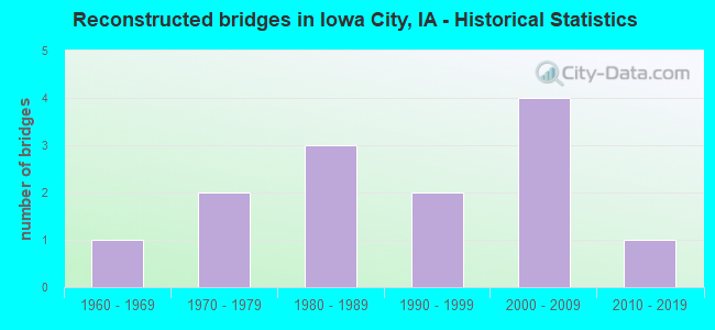
- Reconstructed bridges - Historical Statistics
- 11960-1969
- 21970-1979
- 31980-1989
- 21990-1999
- 42000-2009
- 12010-2019
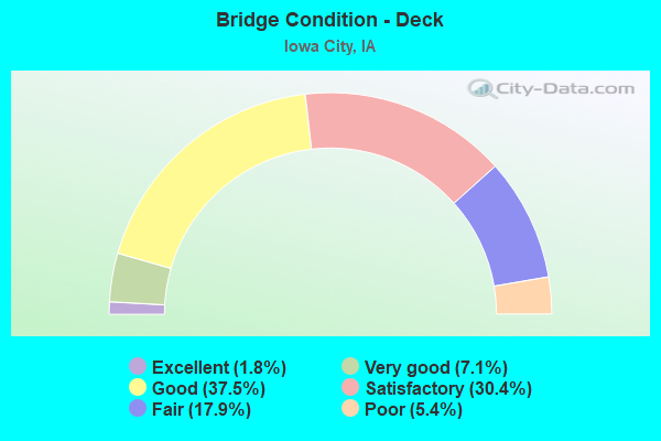
- Bridge Condition - Deck
- 1.8%Excellent
- 7.1%Very good
- 37.5%Good
- 30.4%Satisfactory
- 17.9%Fair
- 5.4%Poor
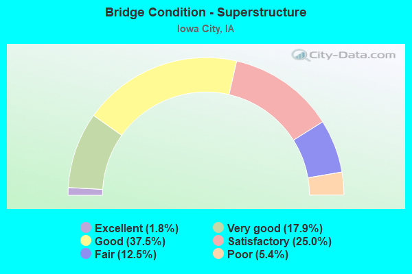
- Bridge Condition - Superstructure
- 1.8%Excellent
- 17.9%Very good
- 37.5%Good
- 25.0%Satisfactory
- 12.5%Fair
- 5.4%Poor
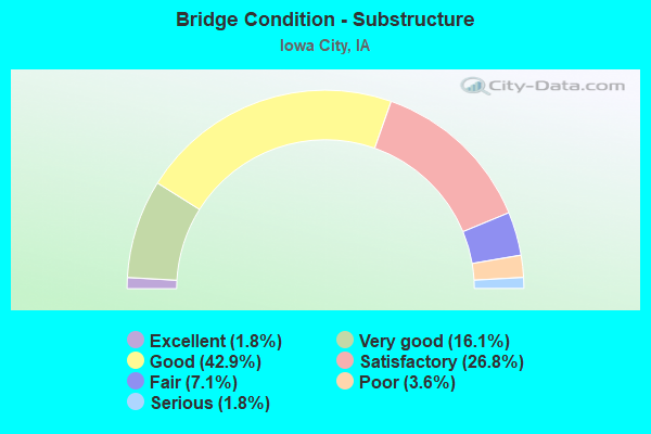
- Bridge Condition - Substructure
- 1.8%Excellent
- 16.1%Very good
- 42.9%Good
- 26.8%Satisfactory
- 7.1%Fair
- 3.6%Poor
- 1.8%Serious
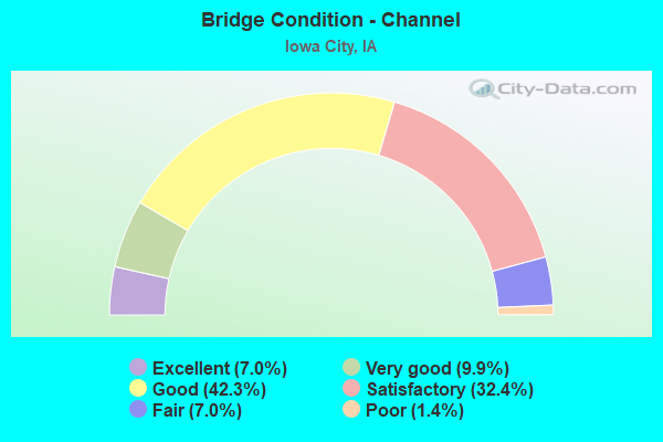
- Bridge Condition - Channel
- 7.0%Excellent
- 9.9%Very good
- 42.3%Good
- 32.4%Satisfactory
- 7.0%Fair
- 1.4%Poor
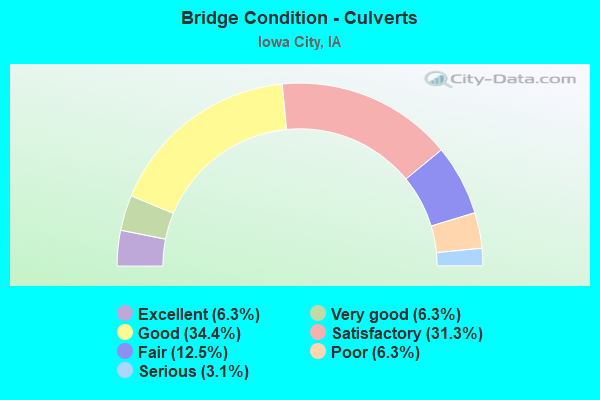
- Bridge Condition - Culverts
- 6.3%Excellent
- 6.3%Very good
- 34.4%Good
- 31.3%Satisfactory
- 12.5%Fair
- 6.3%Poor
- 3.1%Serious
Find on map >> Show street view
Structure Number: 605545, Location: AT JCT U.S. 218 (Lat: 41.634092, Lng: -91.567586), Route carried "on" structure: State highway 1, Year Built: 1983, Status: Open, Structure Length: 8.17m (26.80ft), Average Daily Traffic: 7,950 (year 2020), Truck Traffic: 4%, Average Future Daily Traffic: 7,950 (year 2042), Design Load: HS 20, Features Intersected: US 218
Minimum Vertical Clearance: 30+ m (98+ ft), Kilometerpoint: 57.767, Lanes on structure: 2, Lanes under structure: 4, Owner: State Highway Agency, Approaching Roadway Width: 13.4m (44.0ft), Material/Design: Prestressed concrete, Design/Construction: Stringer/Multi-beam, Number Of Spans In Main Unit: 4, Length of Maximum Span: 28.0m (91.9ft), Curb-To-Curb Width: 12.1m (39.7ft), Out-to-Out Width: 13.1m (43.0ft)
Condition: Deck: Satisfactory, Superstructure: Good, Substructure: Satisfactory, Operating Rating: 59.0 metric tons, Method Used To Determine Operating Rating: Allowable Stress (AS), Inventory Rating: 33.7 metric tons, Method Used To Determine Inventory Rating: Allowable Stress (AS), Structural Evaluation: Equal to present minimum criteria, Deck Geometry: Better than present minimum criteria, Underclear: Better than present minimum criteria, Approach Roadway Alignment: Better than present minimum criteria, Designated Inspection Frequency: Every 24 months, Inspection Date: January 2022, Deck Structure Type: Concrete Cast-file-Place, Wearing Surface/Protective System: Wearing Surface: Monolithic Concrete, Deck Protection: Epoxy Coated Reinforcing
Find on map >> Show street view
Structure Number: 60555, Location: 1.1 mi. N of Jct. Iowa #1 (Lat: 41.646144, Lng: -91.583314), Route carried "on" structure: City street , Year Built: 1983, Status: Open, Structure Length: 12.50m (41.01ft), Average Daily Traffic: 4,830 (year 2018), Average Future Daily Traffic: 4,830 (year 2040), Design Load: H 20, Features Intersected: US 218, Facility Carried by Structure: ROHRET RD
Minimum Vertical Clearance: 30+ m (98+ ft), Kilometerpoint: 1.683, Lanes on structure: 2, Lanes under structure: 4, Owner: State Highway Agency, Approaching Roadway Width: 11.0m (36.1ft), Skew: 4 degrees, Material/Design: Steel continuous, Design/Construction: Stringer/Multi-beam, Number Of Spans In Main Unit: 4, Length of Maximum Span: 40.2m (131.9ft), Curb-To-Curb Width: 9.1m (29.9ft), Out-to-Out Width: 10.1m (33.1ft)
Condition: Deck: Satisfactory, Superstructure: Good, Substructure: Satisfactory, Operating Rating: 53.2 metric tons, Method Used To Determine Operating Rating: Load Factor (LF), Inventory Rating: 31.9 metric tons, Method Used To Determine Inventory Rating: Load Factor (LF), Structural Evaluation: Equal to present minimum criteria, Deck Geometry: Meets minimum limits, Underclear: Superior to present desirable criteria, Approach Roadway Alignment: Equal to present desirable criteria, Designated Inspection Frequency: Every 24 months, Inspection Date: April 2020, Deck Structure Type: Concrete Cast-file-Place, Wearing Surface/Protective System: Wearing Surface: Monolithic Concrete, Deck Protection: Epoxy Coated Reinforcing
Find on map >> Show street view
Structure Number: 605555, Location: 2.3 MI. N OF JCT. IA 1 (Lat: 41.656828, Lng: -91.597278), Route carried "on" structure: US 218, Year Built: 1983, Status: Open, Structure Length: 9.72m (31.89ft), Average Daily Traffic: 12,450 (year 2020), Truck Traffic: 13%, Average Future Daily Traffic: 12,450 (year 2040), Design Load: HS 20, Features Intersected: MELROSE AVE
Minimum Vertical Clearance: 30+ m (98+ ft), Kilometerpoint: 150.850, Lanes on structure: 2, Lanes under structure: 4, Base Highway Network: Yes, Owner: State Highway Agency, Approaching Roadway Width: 14.0m (45.9ft), Skew: 4 degrees, Material/Design: Prestressed concrete, Design/Construction: Stringer/Multi-beam, Number Of Spans In Main Unit: 4, Length of Maximum Span: 29.6m (97.1ft), Curb-To-Curb Width: 12.2m (40.0ft), Out-to-Out Width: 13.2m (43.3ft)
Condition: Deck: Good, Superstructure: Good, Substructure: Good, Operating Rating: 79.8 metric tons, Method Used To Determine Operating Rating: Load Factor (LF), Inventory Rating: 37.3 metric tons, Method Used To Determine Inventory Rating: Load Factor (LF), Structural Evaluation: Better than present minimum criteria, Deck Geometry: Better than present minimum criteria, Underclear: Better than present minimum criteria, Approach Roadway Alignment: Equal to present desirable criteria, Designated Inspection Frequency: Every 24 months, Inspection Date: May 2020, Deck Structure Type: Concrete Cast-file-Place, Wearing Surface/Protective System: Wearing Surface: Monolithic Concrete, Deck Protection: Epoxy Coated Reinforcing
Find on map >> Show street view
Structure Number: 60556, Location: 2.3 MI. N OF JCT. IOWA #1 (Lat: 41.657328, Lng: -91.598447), Route carried "on" structure: US 218, Year Built: 1983, Status: Open, Structure Length: 9.39m (30.81ft), Average Daily Traffic: 12,450 (year 2020), Truck Traffic: 13%, Average Future Daily Traffic: 12,450 (year 2040), Design Load: HS 20, Features Intersected: MELROSE AV
Minimum Vertical Clearance: 30+ m (98+ ft), Kilometerpoint: 287.888, Lanes on structure: 2, Lanes under structure: 4, Owner: State Highway Agency, Approaching Roadway Width: 14.0m (45.9ft), Skew: 4 degrees, Material/Design: Prestressed concrete, Design/Construction: Stringer/Multi-beam, Number Of Spans In Main Unit: 4, Length of Maximum Span: 29.6m (97.1ft), Curb-To-Curb Width: 12.2m (40.0ft), Out-to-Out Width: 13.2m (43.3ft)
Condition: Deck: Satisfactory, Superstructure: Good, Substructure: Good, Operating Rating: 72.8 metric tons, Method Used To Determine Operating Rating: Load Factor (LF), Inventory Rating: 43.6 metric tons, Method Used To Determine Inventory Rating: Load Factor (LF), Structural Evaluation: Better than present minimum criteria, Deck Geometry: Better than present minimum criteria, Underclear: Better than present minimum criteria, Approach Roadway Alignment: Equal to present desirable criteria, Designated Inspection Frequency: Every 24 months, Inspection Date: November 2020, Deck Structure Type: Concrete Cast-file-Place, Wearing Surface/Protective System: Wearing Surface: Monolithic Concrete, Deck Protection: Epoxy Coated Reinforcing
Find on map >> Show street view
Structure Number: 701, Location: 0.8 MI. S, OF SR F52 (Lat: 41.611719, Lng: -91.651672), Route carried "on" structure: State highway 1, Year Built: 2020, Status: Open, Structure Length: 1.14m (3.74ft), Average Daily Traffic: 5,300 (year 2020), Truck Traffic: 11%, Average Future Daily Traffic: 5,300 (year 2042), Design Load: HL 93, Features Intersected: OLD MANS CREEK E OVERFLO
Minimum Vertical Clearance: 30+ m (98+ ft), Kilometerpoint: 126.465, Lanes on structure: 2, Base Highway Network: Yes, Owner: State Highway Agency, Approaching Roadway Width: 13.4m (44.0ft), Material/Design: Concrete, Design/Construction: Culvert, Number Of Spans In Main Unit: 3, Length of Maximum Span: 3.7m (12.1ft)
Condition: Channel: Excellent, Culverts: Very good, Operating Rating: 44.7 metric tons, Method Used To Determine Operating Rating: Load and Resistance Factor Rating (LRFR) rating reported by rating factor(RF) method using HL-93 loadings, Inventory Rating: 34.7 metric tons, Method Used To Determine Inventory Rating: Load and Resistance Factor Rating (LRFR) rating reported by rating factor(RF) method using HL-93 loadings, Structural Evaluation: Equal to present desirable criteria, Waterway Adequacy: Superior to present desirable criteria, Approach Roadway Alignment: Equal to present desirable criteria, Designated Inspection Frequency: Every 24 months, Inspection Date: January 2022
Find on map >> Show street view
Structure Number: 701005, Location: 0.8 mi S of SR F52 (Lat: 41.611947, Lng: -91.651206), Route carried "on" structure: State highway 1, Year Built: 2020, Status: Open, Structure Length: 1.14m (3.74ft), Average Daily Traffic: 5,300 (year 2020), Truck Traffic: 11%, Average Future Daily Traffic: 5,300 (year 2042), Design Load: HL 93, Features Intersected: OLD MANS CREEK E OVERFLO
Minimum Vertical Clearance: 30+ m (98+ ft), Kilometerpoint: 126.512, Lanes on structure: 2, Base Highway Network: Yes, Owner: State Highway Agency, Approaching Roadway Width: 13.4m (44.0ft), Material/Design: Concrete, Design/Construction: Culvert, Number Of Spans In Main Unit: 3, Length of Maximum Span: 3.7m (12.1ft)
Condition: Channel: Excellent, Culverts: Very good, Operating Rating: 44.7 metric tons, Method Used To Determine Operating Rating: Load and Resistance Factor Rating (LRFR) rating reported by rating factor(RF) method using HL-93 loadings, Inventory Rating: 34.7 metric tons, Method Used To Determine Inventory Rating: Load and Resistance Factor Rating (LRFR) rating reported by rating factor(RF) method using HL-93 loadings, Structural Evaluation: Equal to present desirable criteria, Waterway Adequacy: Superior to present desirable criteria, Approach Roadway Alignment: Equal to present desirable criteria, Designated Inspection Frequency: Every 24 months, Inspection Date: January 2022
Find on map >> Show street view
Structure Number: 31541, Location: 000000000 (Lat: 41.664664, Lng: -91.549767), Route carried "under" structure: US 6, Year Built: 1998, Structure Length: 0. m, Average Daily Traffic: 21,300 (year 2020), Truck Traffic: 3%, Features Intersected: US 6 & RR, Facility Carried by Structure: WOOLF AVE
Minimum Vertical Clearance: 30+ m (98+ ft), Kilometerpoint: 412.699, Lanes on structure: 2, Lanes under structure: 4, Material/Design: Concrete continuous, Design/Construction: Slab, Length of Maximum Span: 21.0m (68.9ft)
Find on map >> Show street view
Structure Number: 3177, Location: AT JCT. I-80 (Lat: 41.686394, Lng: -91.499436), Route carried "under" structure: Interstate 80, Year Built: 1962, Structure Length: 0. m, Average Daily Traffic: 17,150 (year 2020), Truck Traffic: 38%, Features Intersected: I-80, Facility Carried by Structure: IA 1 NB
Minimum Vertical Clearance: 30+ m (98+ ft), Kilometerpoint: 395.897, Lanes on structure: 2, Lanes under structure: 6, Material/Design: Steel continuous, Design/Construction: Stringer/Multi-beam, Length of Maximum Span: 20.1m (65.9ft)
Find on map >> Show street view
Structure Number: 3178, Location: AT JCT. I-80 (Lat: 41.687033, Lng: -91.499392), Route carried "under" structure: Interstate 80, Year Built: 1962, Structure Length: 0. m, Average Daily Traffic: 17,150 (year 2020), Truck Traffic: 38%, Features Intersected: I-80, Facility Carried by Structure: IA 1 SB
Minimum Vertical Clearance: 30+ m (98+ ft), Kilometerpoint: 395.866, Lanes on structure: 2, Lanes under structure: 6, Material/Design: Steel continuous, Design/Construction: Stringer/Multi-beam, Length of Maximum Span: 21.3m (69.9ft)
Find on map >> Show street view
Structure Number: 3211, Location: At the jct. of S.R. W66 (Lat: 41.687011, Lng: -91.540319), Route carried "under" structure: Interstate 80, Year Built: 1963, Structure Length: 0. m, Average Daily Traffic: 22,400 (year 2020), Truck Traffic: 30%, Features Intersected: I 80, Facility Carried by Structure: SB DUBUQUE ST
Minimum Vertical Clearance: 30+ m (98+ ft), Kilometerpoint: 392.511, Lanes on structure: 2, Lanes under structure: 6, Material/Design: Steel continuous, Design/Construction: Stringer/Multi-beam, Length of Maximum Span: 20.1m (65.9ft)
Find on map >> Show street view
Structure Number: 3212, Location: At the jct. of S.R. W66 (Lat: 41.686400, Lng: -91.539486), Route carried "under" structure: Interstate 80, Year Built: 1963, Structure Length: 0. m, Average Daily Traffic: 22,400 (year 2020), Truck Traffic: 30%, Features Intersected: I 80, Facility Carried by Structure: NB DUBUQUE ST
Minimum Vertical Clearance: 30+ m (98+ ft), Kilometerpoint: 392.535, Lanes on structure: 2, Lanes under structure: 6, Material/Design: Steel continuous, Design/Construction: Stringer/Multi-beam, Length of Maximum Span: 20.1m (65.9ft)
Find on map >> Show street view
Structure Number: 3213, Location: 1.3 MI. W OF JCT. IA 1 (Lat: 41.687031, Lng: -91.524378), Route carried "under" structure: Interstate 80, Year Built: 1962, Structure Length: 0. m, Average Daily Traffic: 49,800 (year 2020), Truck Traffic: 27%, Features Intersected: I 80, Facility Carried by Structure: PRAIRIEDUCHIEN RD
Minimum Vertical Clearance: 30+ m (98+ ft), Kilometerpoint: 393.811, Lanes on structure: 2, Lanes under structure: 6, Material/Design: Prestressed concrete, Design/Construction: Stringer/Multi-beam, Length of Maximum Span: 19.8m (65.0ft)
Find on map >> Show street view
Structure Number: 3216, Location: 3.0 mi. E of Jct. IA 1 (Lat: 41.671517, Lng: -91.446103), Route carried "under" structure: Interstate 80, Year Built: 1961, Structure Length: 0. m, Average Daily Traffic: 33,800 (year 2020), Truck Traffic: 38%, Features Intersected: I-80, Facility Carried by Structure: F-44
Minimum Vertical Clearance: 30+ m (98+ ft), Kilometerpoint: 400.727, Lanes on structure: 2, Lanes under structure: 4, Material/Design: Steel continuous, Design/Construction: Stringer/Multi-beam, Length of Maximum Span: 26.8m (87.9ft)
Find on map >> Show street view
Structure Number: 3217, Location: 1.2 mi. E of Jct. SR F44 (Lat: 41.667322, Lng: -91.424886), Route carried "under" structure: Interstate 80, Year Built: 1960, Structure Length: 0. m, Average Daily Traffic: 35,800 (year 2020), Truck Traffic: 37%, Features Intersected: I-80, Facility Carried by Structure: FM
Minimum Vertical Clearance: 30+ m (98+ ft), Kilometerpoint: 402.553, Lanes on structure: 2, Lanes under structure: 4, Material/Design: Prestressed concrete, Design/Construction: Stringer/Multi-beam, Length of Maximum Span: 19.8m (65.0ft)
Find on map >> Show street view
Structure Number: 605, Location: 1.6 MI. S OF JCT. IA #1 (Lat: 41.614283, Lng: -91.550356), Route carried "under" structure: US 218, Year Built: 1983, Structure Length: 0. m, Average Daily Traffic: 490 (year 2020), Truck Traffic: 34%, Features Intersected: F50 (OAK CREST HILL RD)
Minimum Vertical Clearance: 30+ m (98+ ft), Kilometerpoint: 0.695, Lanes on structure: 2, Lanes under structure: 2, Material/Design: Prestressed concrete, Design/Construction: Stringer/Multi-beam, Length of Maximum Span: 29.6m (97.1ft)
Find on map >> Show street view
Structure Number: 605005, Location: 1.6 mi. S of Jct. IA 1 (Lat: 41.614892, Lng: -91.550833), Route carried "under" structure: US 218, Year Built: 1983, Structure Length: 0. m, Average Daily Traffic: 490 (year 2020), Truck Traffic: 34%, Features Intersected: F50 (OAK CREST HILL RD)
Minimum Vertical Clearance: 30+ m (98+ ft), Kilometerpoint: 0.665, Lanes on structure: 2, Lanes under structure: 2, Material/Design: Prestressed concrete, Design/Construction: Stringer/Multi-beam, Length of Maximum Span: 29.6m (97.1ft)
Find on map >> Show street view
Structure Number: 605535, Location: 0.8 mi. S of Jct. IA #1 (Lat: 41.625017, Lng: -91.560211), Route carried "under" structure: US 218, Year Built: 1983, Structure Length: 0. m, Average Daily Traffic: 17,000 (year 2020), Truck Traffic: 16%, Features Intersected: US 218, Facility Carried by Structure: DANE RD
Minimum Vertical Clearance: 30+ m (98+ ft), Kilometerpoint: 146.182, Lanes on structure: 2, Lanes under structure: 4, Material/Design: Steel continuous, Design/Construction: Stringer/Multi-beam, Length of Maximum Span: 40.2m (131.9ft)
Find on map >> Show street view
Structure Number: 60554, Location: AT JCT U.S. 218 (Lat: 41.633389, Lng: -91.568050), Route carried "under" structure: US 218, Year Built: 1983, Structure Length: 0. m, Average Daily Traffic: 7,250 (year 2020), Truck Traffic: 19%, Features Intersected: US 218, Facility Carried by Structure: NB IA 1
Minimum Vertical Clearance: 30+ m (98+ ft), Kilometerpoint: 147.271, Lanes on structure: 2, Lanes under structure: 4, Material/Design: Prestressed concrete, Design/Construction: Stringer/Multi-beam, Length of Maximum Span: 28.0m (91.9ft)
Find on map >> Show street view
Structure Number: 605545, Location: AT JCT U.S. 218 (Lat: 41.634092, Lng: -91.567586), Route carried "under" structure: US 218, Year Built: 1983, Structure Length: 0. m, Average Daily Traffic: 7,250 (year 2020), Truck Traffic: 19%, Features Intersected: US 218, Facility Carried by Structure: SB IA 1
Minimum Vertical Clearance: 30+ m (98+ ft), Kilometerpoint: 147.300, Lanes on structure: 2, Lanes under structure: 4, Material/Design: Prestressed concrete, Design/Construction: Stringer/Multi-beam, Length of Maximum Span: 28.0m (91.9ft)
Find on map >> Show street view
Structure Number: 60555, Location: 1.1 mi. N of Jct. Iowa #1 (Lat: 41.646144, Lng: -91.583314), Route carried "under" structure: US 218, Year Built: 1983, Structure Length: 0. m, Average Daily Traffic: 30,000 (year 2020), Truck Traffic: 12%, Features Intersected: US 218, Facility Carried by Structure: ROHRET RD
Minimum Vertical Clearance: 30+ m (98+ ft), Kilometerpoint: 149.131, Lanes on structure: 2, Lanes under structure: 4, Material/Design: Steel continuous, Design/Construction: Stringer/Multi-beam, Length of Maximum Span: 40.2m (131.9ft)
Find on map >> Show street view
Structure Number: 605555, Location: 2.3 MI. N OF JCT. IA 1 (Lat: 41.656828, Lng: -91.597278), Route carried "under" structure: City street , Year Built: 1983, Structure Length: 0. m, Average Daily Traffic: 2,650 (year 2018), Features Intersected: MELROSE AVE, Facility Carried by Structure: NB US 218
Minimum Vertical Clearance: 30+ m (98+ ft), Kilometerpoint: 1.017, Lanes on structure: 2, Lanes under structure: 4, Material/Design: Prestressed concrete, Design/Construction: Stringer/Multi-beam, Length of Maximum Span: 29.6m (97.1ft)
Find on map >> Show street view
Structure Number: 60556, Location: 2.3 MI. N OF JCT. IOWA #1 (Lat: 41.657328, Lng: -91.598447), Route carried "under" structure: City street , Year Built: 1983, Structure Length: 0. m, Average Daily Traffic: 2,650 (year 2018), Features Intersected: MELROSE AV, Facility Carried by Structure: SB US 218
Minimum Vertical Clearance: 30+ m (98+ ft), Kilometerpoint: 0.972, Lanes on structure: 2, Lanes under structure: 4, Material/Design: Prestressed concrete, Design/Construction: Stringer/Multi-beam, Length of Maximum Span: 29.6m (97.1ft)