Bridge Statistics for Lafayette, Louisiana (LA)
Condition, Traffic, Stress, Structural Evaluation, Project Costs
- National Bridge Inventory (NBI) Statistics
- 219Number of bridges
- 2,244ft / 684mTotal length
- $19,803,000Total costs
- 3,605,824Total average daily traffic
- 430,770Total average daily truck traffic
- National Bridge Inventory (NBI) Registered Bridges for Lafayette
- No street view available for this location
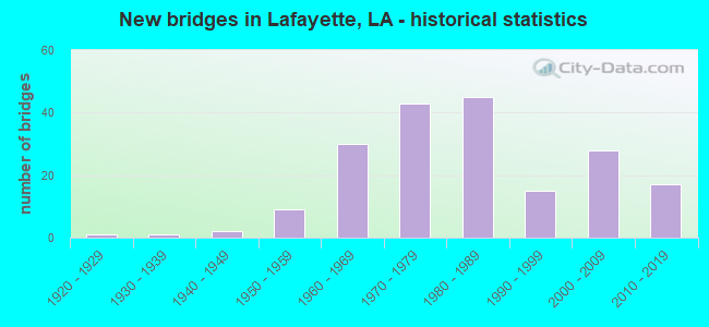
- New bridges - historical statistics
- 11920-1929
- 11930-1939
- 21940-1949
- 91950-1959
- 301960-1969
- 431970-1979
- 451980-1989
- 151990-1999
- 282000-2009
- 172010-2019
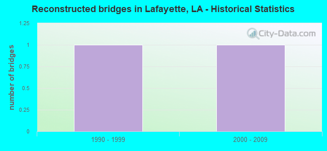
- Reconstructed bridges - Historical Statistics
- 11990-1999
- 12000-2009
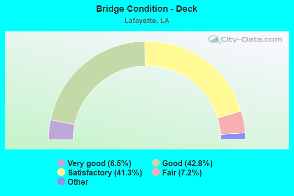
- Bridge Condition - Deck
- 6.5%Excellent
- 42.8%Very good
- 41.3%Good
- 7.2%Satisfactory
- 2.2%Fair
- 0.7%Poor
- 0.7%Failed
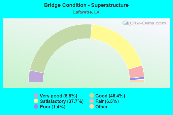
- Bridge Condition - Superstructure
- 6.5%Excellent
- 46.4%Very good
- 37.7%Good
- 6.5%Satisfactory
- 1.4%Fair
- 1.4%Poor
- 0.7%Failed
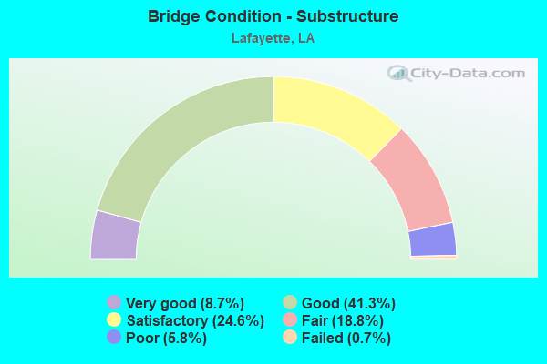
- Bridge Condition - Substructure
- 8.7%Very good
- 41.3%Good
- 24.6%Satisfactory
- 18.8%Fair
- 5.8%Poor
- 0.7%Failed
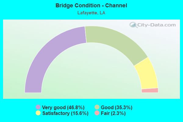
- Bridge Condition - Channel
- 46.8%Very good
- 35.3%Good
- 15.6%Satisfactory
- 2.3%Fair
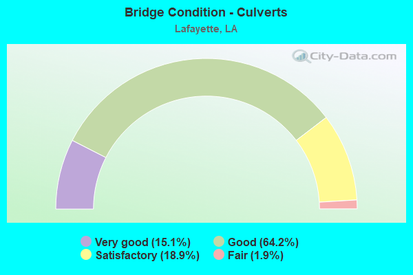
- Bridge Condition - Culverts
- 15.1%Very good
- 64.2%Good
- 18.9%Satisfactory
- 1.9%Fair
Find on map >> Show street view
Structure Number: 32800800302051, Location: 2.05 MI EAST OF US 90 (Lat: 30.232300, Lng: -91.983700), Route carried "on" structure: State highway 94, Year Built: 2000, Status: Open, Structure Length: 1.65m (5.41ft), Average Daily Traffic: 12,700 (year 2016), Truck Traffic: 9%, Average Future Daily Traffic: 16,128 (year 2036), Design Load: HS 20, Features Intersected: COULEE
Minimum Vertical Clearance: 30+ m (98+ ft), Kilometerpoint: 2.316, Lanes on structure: 3, Owner: State Highway Agency, Approaching Roadway Width: 26.5m (86.9ft), Skew: 20 degrees, Material/Design: Prestressed concrete, Design/Construction: Stringer/Multi-beam, Number Of Spans In Main Unit: 1, Length of Maximum Span: 16.5m (54.1ft), Curb-To-Curb Width: 25.5m (83.7ft), Out-to-Out Width: 26.9m (88.3ft)
Condition: Deck: Good, Superstructure: Very good, Substructure: Very good, Channel: Very good, Operating Rating: 70.7 metric tons, Method Used To Determine Operating Rating: Load Factor (LF), Inventory Rating: 41.7 metric tons, Method Used To Determine Inventory Rating: Load Factor (LF), Structural Evaluation: Equal to present desirable criteria, Deck Geometry: Superior to present desirable criteria, Waterway Adequacy: Equal to present desirable criteria, Approach Roadway Alignment: Equal to present desirable criteria, Designated Inspection Frequency: Every 24 months, Inspection Date: September 2020, Deck Structure Type: Concrete Cast-file-Place, Wearing Surface/Protective System: Wearing Surface: Monolithic Concrete
Find on map >> Show street view
Structure Number: 32802130500001, Location: 1.2 MI WEST OF LA 733 (Lat: 30.103819, Lng: -92.080231), Route carried "on" structure: State highway 92, Year Built: 1948, Status: Posted for load, Structure Length: 10.24m (33.60ft), Average Daily Traffic: 10,000 (year 2016), Truck Traffic: 9%, Average Future Daily Traffic: 12,348 (year 2036), Design Load: H 15, Features Intersected: VERMILION R @ MILTON
Minimum Vertical Clearance: 5.01m (16.44ft), Kilometerpoint: 0.000, Lanes on structure: 2, Owner: State Highway Agency, Approaching Roadway Width: 9.8m (32.2ft), Navigation Control: Yes ( Vertical Clearance: 18.3m (60.0ft), Horizontal Clearance: 14.6m (47.9ft)), Material/Design: Steel, Design/Construction: Movable - Lift, Number Of Spans In Main Unit: 1, Number Of Approach Spans: 6, Length of Maximum Span: 29.3m (96.1ft), Curb-To-Curb Width: 7.3m (24.0ft), Out-to-Out Width: 9.2m (30.2ft)
Condition: Deck: Satisfactory, Superstructure: Satisfactory, Substructure: Satisfactory, Channel: Satisfactory, Operating Rating: 22.0 metric tons, Method Used To Determine Operating Rating: Load and Resistance Factor Rating (LRFR) rating reported by rating factor(RF) method using HL-93 loadings, Inventory Rating: 17.2 metric tons, Method Used To Determine Inventory Rating: Load and Resistance Factor Rating (LRFR) rating reported by rating factor(RF) method using HL-93 loadings, Structural Evaluation: Meets minimum limits, Deck Geometry: High priority of replacement, Waterway Adequacy: Equal to present desirable criteria, Approach Roadway Alignment: Equal to present desirable criteria, Bridge Posting: Required (Relationship of Operating Rating to Maximum Legal Load: 20.0 - 29.9% below), Length Of Structure Improvement: 11.16m (36.61ft), Designated Inspection Frequency: Every 24 months, Critical Feature Inspection Frequency: Every 24 months, Underwater Inspection Frequency: Every 60 months, Inspection Date: August 2020, Critical Feature Inspection Date: August 2020, Underwater Inspection Date: July 2018, Bridge Improvement Cost: $951,000, Total Project Cost: $1,426,000 ( Estimate for 2016), Deck Structure Type: Open Grating
Find on map >> Show street view
Structure Number: 32802130502441, Location: 1.2 MI EAST OF LA 733 (Lat: 30.109250, Lng: -92.041200), Route carried "on" structure: State highway 92, Year Built: 1973, Status: Posted for load, Structure Length: 1.74m (5.71ft), Average Daily Traffic: 10,000 (year 2016), Truck Traffic: 9%, Average Future Daily Traffic: 12,348 (year 2036), Design Load: HS 20, Features Intersected: ANSEIM COUIEE
Minimum Vertical Clearance: 30+ m (98+ ft), Kilometerpoint: 3.874, Lanes on structure: 2, Owner: State Highway Agency, Approaching Roadway Width: 7.6m (24.9ft), Material/Design: Concrete, Design/Construction: Slab, Number Of Spans In Main Unit: 3, Length of Maximum Span: 5.8m (19.0ft), Curb-To-Curb Width: 12.2m (40.0ft), Out-to-Out Width: 13.2m (43.3ft)
Condition: Deck: Satisfactory, Superstructure: Satisfactory, Substructure: Fair, Channel: Good, Operating Rating: 26.9 metric tons, Method Used To Determine Operating Rating: Load and Resistance Factor Rating (LRFR) rating reported by rating factor(RF) method using HL-93 loadings, Inventory Rating: 20.7 metric tons, Method Used To Determine Inventory Rating: Load and Resistance Factor Rating (LRFR) rating reported by rating factor(RF) method using HL-93 loadings, Structural Evaluation: Somewhat better than minimum adequacy, Deck Geometry: Somewhat better than minimum adequacy, Waterway Adequacy: Equal to present desirable criteria, Approach Roadway Alignment: Equal to present desirable criteria, Bridge Posting: Required (Relationship of Operating Rating to Maximum Legal Load: 10.0 - 19.9% below), Designated Inspection Frequency: Every 24 months, Inspection Date: Febuary 2022, Deck Structure Type: Concrete Cast-file-Place, Wearing Surface/Protective System: Wearing Surface: Bituminous
Find on map >> Show street view
Structure Number: 32802160305051, Location: 0.1 MI WEST OF US 90 (Lat: 30.169311, Lng: -91.981831), Route carried "on" structure: State highway 89, Year Built: 1976, Status: Open, Structure Length: 2.32m (7.61ft), Average Daily Traffic: 15,200 (year 2016), Truck Traffic: 9%, Average Future Daily Traffic: 18,900 (year 2036), Design Load: HS 20, Features Intersected: COULEE DES POCHES
Minimum Vertical Clearance: 30+ m (98+ ft), Kilometerpoint: 8.127, Lanes on structure: 2, Owner: State Highway Agency, Approaching Roadway Width: 12.2m (40.0ft), Material/Design: Concrete, Design/Construction: Slab, Number Of Spans In Main Unit: 4, Length of Maximum Span: 5.8m (19.0ft), Curb-To-Curb Width: 12.2m (40.0ft), Out-to-Out Width: 13.1m (43.0ft)
Condition: Deck: Satisfactory, Superstructure: Satisfactory, Substructure: Satisfactory, Channel: Satisfactory, Operating Rating: 59.9 metric tons, Method Used To Determine Operating Rating: Load Factor (LF), Inventory Rating: 36.3 metric tons, Method Used To Determine Inventory Rating: Load Factor (LF), Structural Evaluation: Equal to present minimum criteria, Deck Geometry: Somewhat better than minimum adequacy, Waterway Adequacy: Equal to present desirable criteria, Approach Roadway Alignment: Equal to present desirable criteria, Designated Inspection Frequency: Every 24 months, Inspection Date: June 2020, Deck Structure Type: Concrete Cast-file-Place, Wearing Surface/Protective System: Wearing Surface: Bituminous
Find on map >> Show street view
Structure Number: 32802180109671, Location: 2.0 MI EAST OF LA 724 (Lat: 30.181469, Lng: -92.107800), Route carried "on" structure: State highway 342, Year Built: 1996, Status: Open, Structure Length: 3.66m (12.01ft), Average Daily Traffic: 13,400 (year 2016), Truck Traffic: 9%, Average Future Daily Traffic: 17,010 (year 2036), Design Load: HS 20, Features Intersected: COULEE ILE DES CANNES
Minimum Vertical Clearance: 30+ m (98+ ft), Kilometerpoint: 15.512, Lanes on structure: 2, Owner: State Highway Agency, Approaching Roadway Width: 12.2m (40.0ft), Material/Design: Concrete, Design/Construction: Slab, Number Of Spans In Main Unit: 6, Length of Maximum Span: 6.1m (20.0ft), Curb-To-Curb Width: 12.2m (40.0ft), Out-to-Out Width: 13.0m (42.7ft)
Condition: Deck: Good, Superstructure: Good, Substructure: Good, Channel: Good, Operating Rating: 73.5 metric tons, Method Used To Determine Operating Rating: Load Factor (LF), Inventory Rating: 43.5 metric tons, Method Used To Determine Inventory Rating: Load Factor (LF), Structural Evaluation: Better than present minimum criteria, Deck Geometry: Somewhat better than minimum adequacy, Waterway Adequacy: Equal to present desirable criteria, Approach Roadway Alignment: Equal to present desirable criteria, Designated Inspection Frequency: Every 24 months, Inspection Date: September 2020, Deck Structure Type: Concrete Cast-file-Place
Find on map >> Show street view
Structure Number: 32802180110971, Location: 0.3 MI EAST OF LA 342 (Lat: 30.181281, Lng: -92.086211), Route carried "on" structure: County highway , Year Built: 1997, Status: Open, Structure Length: 4.88m (16.01ft), Average Daily Traffic: 13,000 (year 2020), Average Future Daily Traffic: 31,958 (year 2040), Design Load: HS 20, Features Intersected: DRAINAGE CANAL, Facility Carried by Structure: Ridge Rd.
Minimum Vertical Clearance: 30+ m (98+ ft), Kilometerpoint: 0.000, Lanes on structure: 2, Owner: County Highway Agency, Approaching Roadway Width: 7.6m (24.9ft), Skew: 4 degrees, Material/Design: Concrete, Design/Construction: Slab, Number Of Spans In Main Unit: 8, Length of Maximum Span: 6.1m (20.0ft), Curb-To-Curb Width: 12.2m (40.0ft), Out-to-Out Width: 13.0m (42.7ft)
Condition: Deck: Good, Superstructure: Good, Substructure: Good, Channel: Good, Operating Rating: 31.1 metric tons, Method Used To Determine Operating Rating: Load and Resistance Factor Rating (LRFR) rating reported by rating factor(RF) method using HL-93 loadings, Inventory Rating: 24.0 metric tons, Method Used To Determine Inventory Rating: Load and Resistance Factor Rating (LRFR) rating reported by rating factor(RF) method using HL-93 loadings, Structural Evaluation: Somewhat better than minimum adequacy, Deck Geometry: Somewhat better than minimum adequacy, Waterway Adequacy: Equal to present desirable criteria, Approach Roadway Alignment: Equal to present desirable criteria, Designated Inspection Frequency: Every 24 months, Inspection Date: January 2022, Deck Structure Type: Concrete Cast-file-Place
Find on map >> Show street view
Structure Number: 32803910208351, Location: 1.04 MI EAST OF LA 728 (Lat: 30.293961, Lng: -91.989550), Route carried "on" structure: State highway 98, Year Built: 1983, Status: Posted for load, Structure Length: 1.16m (3.81ft), Average Daily Traffic: 12,200 (year 2016), Truck Traffic: 9%, Average Future Daily Traffic: 14,616 (year 2036), Design Load: HS 20, Features Intersected: COULEE
Minimum Vertical Clearance: 30+ m (98+ ft), Kilometerpoint: 13.438, Lanes on structure: 2, Owner: State Highway Agency, Approaching Roadway Width: 6.9m (22.6ft), Material/Design: Concrete, Design/Construction: Slab, Number Of Spans In Main Unit: 2, Length of Maximum Span: 5.8m (19.0ft), Curb-To-Curb Width: 7.3m (24.0ft), Out-to-Out Width: 8.3m (27.2ft)
Condition: Deck: Poor, Superstructure: Poor, Substructure: Fair, Channel: Satisfactory, Operating Rating: 22.0 metric tons, Method Used To Determine Operating Rating: Load and Resistance Factor Rating (LRFR) rating reported by rating factor(RF) method using HL-93 loadings, Inventory Rating: 16.8 metric tons, Method Used To Determine Inventory Rating: Load and Resistance Factor Rating (LRFR) rating reported by rating factor(RF) method using HL-93 loadings, Structural Evaluation: Meets minimum limits, Deck Geometry: High priority of replacement, Waterway Adequacy: Better than present minimum criteria, Approach Roadway Alignment: Equal to present desirable criteria, Bridge Posting: Required (Relationship of Operating Rating to Maximum Legal Load: 0.1 - 9.9% below), Length Of Structure Improvement: 1.83m (6.00ft), Designated Inspection Frequency: Every 24 months, Other Special Inspection Frequency: Every 12 months, Inspection Date: Febuary 2022, Other Special Inspection Date: Febuary 2021, Bridge Improvement Cost: $156,000, Total Project Cost: $234,000 ( Estimate for 2016), Deck Structure Type: Concrete Precast Panels
Find on map >> Show street view
Structure Number: 32803910209091, Location: 1.4 MI EAST OF LA 314 (Lat: 30.293700, Lng: -91.983300), Route carried "on" structure: State highway 98, Year Built: 1971, Status: Open, Structure Length: 4.11m (13.48ft), Average Daily Traffic: 12,200 (year 2016), Truck Traffic: 9%, Average Future Daily Traffic: 14,616 (year 2036), Design Load: HS 20, Features Intersected: VERMILION RIVER
Minimum Vertical Clearance: 30+ m (98+ ft), Kilometerpoint: 15.495, Lanes on structure: 2, Owner: State Highway Agency, Approaching Roadway Width: 9.1m (29.9ft), Material/Design: Concrete, Design/Construction: Slab, Number Of Spans In Main Unit: 7, Length of Maximum Span: 5.8m (19.0ft), Curb-To-Curb Width: 6.1m (20.0ft), Out-to-Out Width: 7.1m (23.3ft)
Condition: Deck: Fair, Superstructure: Fair, Substructure: Fair, Channel: Satisfactory, Operating Rating: 46.3 metric tons, Method Used To Determine Operating Rating: Load Factor (LF), Inventory Rating: 27.2 metric tons, Method Used To Determine Inventory Rating: Load Factor (LF), Structural Evaluation: Somewhat better than minimum adequacy, Deck Geometry: High priority of replacement, Waterway Adequacy: Equal to present desirable criteria, Approach Roadway Alignment: Better than present minimum criteria, Length Of Structure Improvement: 5.03m (16.50ft), Designated Inspection Frequency: Every 24 months, Underwater Inspection Frequency: Every 60 months, Inspection Date: May 2020, Underwater Inspection Date: July 2018, Bridge Improvement Cost: $429,000, Total Project Cost: $643,000 ( Estimate for 2016), Deck Structure Type: Concrete Precast Panels
Find on map >> Show street view
Structure Number: 32803910209731, Location: 2.09 MI EAST OF LA 728 (Lat: 30.293331, Lng: -91.972800), Route carried "on" structure: State highway 98, Year Built: 1987, Status: Open, Structure Length: 4.05m (13.29ft), Average Daily Traffic: 12,200 (year 2016), Truck Traffic: 9%, Average Future Daily Traffic: 14,616 (year 2036), Design Load: HS 20, Features Intersected: BAYOU ST. CLAIRE
Minimum Vertical Clearance: 30+ m (98+ ft), Kilometerpoint: 16.528, Lanes on structure: 2, Owner: State Highway Agency, Approaching Roadway Width: 12.8m (42.0ft), Material/Design: Concrete, Design/Construction: Slab, Number Of Spans In Main Unit: 7, Length of Maximum Span: 5.8m (19.0ft), Curb-To-Curb Width: 9.8m (32.2ft), Out-to-Out Width: 10.6m (34.8ft)
Condition: Deck: Good, Superstructure: Good, Substructure: Good, Channel: Good, Operating Rating: 89.8 metric tons, Method Used To Determine Operating Rating: Load Factor (LF), Inventory Rating: 57.1 metric tons, Method Used To Determine Inventory Rating: Load Factor (LF), Structural Evaluation: Better than present minimum criteria, Deck Geometry: Meets minimum limits, Waterway Adequacy: Equal to present desirable criteria, Approach Roadway Alignment: Equal to present desirable criteria, Designated Inspection Frequency: Every 24 months, Inspection Date: Febuary 2022, Deck Structure Type: Concrete Precast Panels
Find on map >> Show street view
Structure Number: 32804240203441, Location: 0.3 MI S. OF US 90BUS (Lat: 30.214389, Lng: -92.000800), Route carried "on" structure: US 90, Year Built: 1965, Status: Open, Structure Length: 12.41m (40.72ft), Average Daily Traffic: 21,450 (year 2016), Truck Traffic: 10%, Average Future Daily Traffic: 32,281 (year 2036), Design Load: HS 20, Features Intersected: VERMILION RIVER
Minimum Vertical Clearance: 30+ m (98+ ft), Kilometerpoint: 5.480, Lanes on structure: 2, Base Highway Network: Yes (Inventory Route: 424-02-1, Subroute: 10), Owner: State Highway Agency, Approaching Roadway Width: 11.6m (38.1ft), Skew: 12 degrees, Material/Design: Prestressed concrete, Design/Construction: Stringer/Multi-beam, Number Of Spans In Main Unit: 6, Length of Maximum Span: 21.3m (69.9ft), Curb-To-Curb Width: 14.9m (48.9ft), Out-to-Out Width: 16.5m (54.1ft)
Condition: Deck: Satisfactory, Superstructure: Good, Substructure: Good, Channel: Good, Operating Rating: 50.2 metric tons, Method Used To Determine Operating Rating: Load and Resistance Factor Rating (LRFR) rating reported by rating factor(RF) method using HL-93 loadings, Inventory Rating: 28.5 metric tons, Method Used To Determine Inventory Rating: Load and Resistance Factor Rating (LRFR) rating reported by rating factor(RF) method using HL-93 loadings, Structural Evaluation: Better than present minimum criteria, Deck Geometry: Superior to present desirable criteria, Waterway Adequacy: Equal to present desirable criteria, Approach Roadway Alignment: Equal to present desirable criteria, Designated Inspection Frequency: Every 24 months, Underwater Inspection Frequency: Every 60 months, Inspection Date: September 2020, Underwater Inspection Date: July 2018, Deck Structure Type: Concrete Cast-file-Place
Find on map >> Show street view
Structure Number: 32804240203442, Location: 2.34 Mi N of LA 339 (Lat: 30.213561, Lng: -92.000000), Route carried "on" structure: US 90, Year Built: 1965, Status: Open, Structure Length: 10.42m (34.19ft), Average Daily Traffic: 21,450 (year 2016), Truck Traffic: 10%, Average Future Daily Traffic: 32,281 (year 2036), Design Load: HS 20, Features Intersected: VERMILION RIVER
Minimum Vertical Clearance: 30+ m (98+ ft), Kilometerpoint: 14.848, Lanes on structure: 2, Base Highway Network: Yes (Inventory Route: 424-02-2, Subroute: 10), Owner: State Highway Agency, Approaching Roadway Width: 11.6m (38.1ft), Skew: 12 degrees, Material/Design: Prestressed concrete, Design/Construction: Stringer/Multi-beam, Number Of Spans In Main Unit: 5, Length of Maximum Span: 21.3m (69.9ft), Curb-To-Curb Width: 14.9m (48.9ft), Out-to-Out Width: 16.5m (54.1ft)
Condition: Deck: Satisfactory, Superstructure: Good, Substructure: Good, Channel: Good, Operating Rating: 50.2 metric tons, Method Used To Determine Operating Rating: Load and Resistance Factor Rating (LRFR) rating reported by rating factor(RF) method using HL-93 loadings, Inventory Rating: 28.5 metric tons, Method Used To Determine Inventory Rating: Load and Resistance Factor Rating (LRFR) rating reported by rating factor(RF) method using HL-93 loadings, Structural Evaluation: Better than present minimum criteria, Deck Geometry: Superior to present desirable criteria, Waterway Adequacy: Equal to present desirable criteria, Approach Roadway Alignment: Equal to present desirable criteria, Designated Inspection Frequency: Every 24 months, Underwater Inspection Frequency: Every 60 months, Inspection Date: September 2020, Underwater Inspection Date: July 2018, Deck Structure Type: Concrete Cast-file-Place
Find on map >> Show street view
Structure Number: 32804500503682, Location: 0.4 MI WEST OF LA 93 (Lat: 30.247381, Lng: -92.114300), Route carried "on" structure: Interstate 10, Year Built: 1968, Status: Open, Structure Length: 3.05m (10.01ft), Average Daily Traffic: 32,450 (year 2016), Truck Traffic: 28%, Average Future Daily Traffic: 40,143 (year 2036), Design Load: HS 20, Features Intersected: B ILE DES CANNES
Minimum Vertical Clearance: 30+ m (98+ ft), Kilometerpoint: 16.536, Lanes on structure: 2, Base Highway Network: Yes (Inventory Route: 450-05-2, Subroute: 10), Owner: State Highway Agency, Approaching Roadway Width: 12.8m (42.0ft), Skew: 10 degrees, Material/Design: Concrete, Design/Construction: Slab, Number Of Spans In Main Unit: 5, Length of Maximum Span: 6.1m (20.0ft), Curb-To-Curb Width: 12.1m (39.7ft), Out-to-Out Width: 13.0m (42.7ft)
Condition: Deck: Satisfactory, Superstructure: Satisfactory, Substructure: Good, Channel: Satisfactory, Operating Rating: 71.7 metric tons, Method Used To Determine Operating Rating: Load Factor (LF), Inventory Rating: 43.5 metric tons, Method Used To Determine Inventory Rating: Load Factor (LF), Structural Evaluation: Equal to present minimum criteria, Deck Geometry: Equal to present minimum criteria, Waterway Adequacy: Better than present minimum criteria, Approach Roadway Alignment: Equal to present desirable criteria, Designated Inspection Frequency: Every 24 months, Inspection Date: September 2020, Deck Structure Type: Concrete Cast-file-Place
Find on map >> Show street view
Structure Number: 32804500505081, Location: 1.0 MI EAST OF LA 93 (Lat: 30.246739, Lng: -92.091300), Route carried "on" structure: County highway , Year Built: 1968, Status: Open, Structure Length: 6.77m (22.21ft), Average Daily Traffic: 6,950 (year 2015), Average Future Daily Traffic: 8,757 (year 2036), Design Load: HS 20, Features Intersected: I-10, Facility Carried by Structure: Mills St
Minimum Vertical Clearance: 30+ m (98+ ft), Kilometerpoint: 8.161, Lanes on structure: 2, Lanes under structure: 4, Base Highway Network: Yes (Inventory Route: 450-05-1, Subroute: 10), Owner: State Highway Agency, Approaching Roadway Width: 10.1m (33.1ft), Material/Design: Prestressed concrete, Design/Construction: Stringer/Multi-beam, Number Of Spans In Main Unit: 2, Number Of Approach Spans: 2, Length of Maximum Span: 21.3m (69.9ft), Curb-To-Curb Width: 7.3m (24.0ft), Out-to-Out Width: 9.1m (29.9ft)
Condition: Deck: Good, Superstructure: Satisfactory, Substructure: Good, Operating Rating: 84.4 metric tons, Method Used To Determine Operating Rating: Load Factor (LF), Inventory Rating: 35.4 metric tons, Method Used To Determine Inventory Rating: Load Factor (LF), Structural Evaluation: Equal to present minimum criteria, Deck Geometry: High priority of replacement, Underclear: Meets minimum limits, Approach Roadway Alignment: Equal to present desirable criteria, Length Of Structure Improvement: 7.68m (25.20ft), Designated Inspection Frequency: Every 24 months, Inspection Date: September 2020, Bridge Improvement Cost: $655,000, Total Project Cost: $982,000 ( Estimate for 2016), Deck Structure Type: Concrete Cast-file-Place
Find on map >> Show street view
Structure Number: 32804500505811, Location: 1.8 MI EAST OF LA 93 (Lat: 30.246900, Lng: -92.079100), Route carried "on" structure: Interstate 10, Year Built: 1968, Status: Open, Structure Length: 1.25m (4.10ft), Average Daily Traffic: 71,600 (year 2016), Truck Traffic: 28%, Average Future Daily Traffic: 87,570 (year 2036), Design Load: HS 20, Features Intersected: DRAIN
Minimum Vertical Clearance: 30+ m (98+ ft), Kilometerpoint: 9.342, Lanes on structure: 4, Base Highway Network: Yes (Inventory Route: 450-05-1, Subroute: 10), Owner: State Highway Agency, Approaching Roadway Width: 23.2m (76.1ft), Skew: 13 degrees, Material/Design: Concrete, Design/Construction: Culvert, Number Of Spans In Main Unit: 4, Length of Maximum Span: 2.4m (7.9ft)
Condition: Channel: Fair, Culverts: Satisfactory, Operating Rating: 42.1 metric tons, Method Used To Determine Operating Rating: Load and Resistance Factor Rating (LRFR) rating reported by rating factor(RF) method using HL-93 loadings, Inventory Rating: 32.4 metric tons, Method Used To Determine Inventory Rating: Load and Resistance Factor Rating (LRFR) rating reported by rating factor(RF) method using HL-93 loadings, Structural Evaluation: Equal to present minimum criteria, Waterway Adequacy: Equal to present desirable criteria, Approach Roadway Alignment: Equal to present desirable criteria, Designated Inspection Frequency: Every 24 months, Inspection Date: September 2020, Deck Structure Type: Concrete Cast-file-Place
Find on map >> Show street view
Structure Number: 32804500506221, Location: 2.2 MI EAST OF LA 93 (Lat: 30.246861, Lng: -92.072200), Route carried "on" structure: Interstate 10, Year Built: 1968, Status: Open, Structure Length: 0.91m (2.99ft), Average Daily Traffic: 71,600 (year 2016), Truck Traffic: 28%, Average Future Daily Traffic: 87,570 (year 2036), Design Load: HS 20, Features Intersected: COULEE MINE
Minimum Vertical Clearance: 30+ m (98+ ft), Kilometerpoint: 10.000, Lanes on structure: 4, Base Highway Network: Yes (Inventory Route: 450-05-1, Subroute: 10), Owner: State Highway Agency, Approaching Roadway Width: 23.2m (76.1ft), Skew: 10 degrees, Material/Design: Concrete, Design/Construction: Culvert, Number Of Spans In Main Unit: 3, Length of Maximum Span: 2.7m (8.9ft), Curb-To-Curb Width: 23.2m (76.1ft), Out-to-Out Width: 48.7m (159.8ft)
Condition: Channel: Satisfactory, Culverts: Satisfactory, Operating Rating: 42.1 metric tons, Method Used To Determine Operating Rating: Load and Resistance Factor Rating (LRFR) rating reported by rating factor(RF) method using HL-93 loadings, Inventory Rating: 32.4 metric tons, Method Used To Determine Inventory Rating: Load and Resistance Factor Rating (LRFR) rating reported by rating factor(RF) method using HL-93 loadings, Structural Evaluation: Equal to present minimum criteria, Deck Geometry: Superior to present desirable criteria, Waterway Adequacy: Equal to present desirable criteria, Approach Roadway Alignment: Equal to present desirable criteria, Designated Inspection Frequency: Every 24 months, Inspection Date: September 2020, Deck Structure Type: Concrete Cast-file-Place
Find on map >> Show street view
Structure Number: 32804500506571, Location: 0.5 MI S of LA 725 (Lat: 30.246650, Lng: -92.066300), Route carried "on" structure: County highway , Year Built: 1968, Status: Open, Structure Length: 6.77m (22.21ft), Average Daily Traffic: 41,000 (year 2016), Truck Traffic: 10%, Average Future Daily Traffic: 51,660 (year 2036), Design Load: HS 20, Features Intersected: I-10, Facility Carried by Structure: Ambassador Caffery
Minimum Vertical Clearance: 30+ m (98+ ft), Kilometerpoint: 3.224, Lanes on structure: 2, Lanes under structure: 4, Base Highway Network: Yes (Inventory Route: 828-45-1, Subroute: 10), Owner: State Highway Agency, Approaching Roadway Width: 14.3m (46.9ft), Material/Design: Prestressed concrete, Design/Construction: Stringer/Multi-beam, Number Of Spans In Main Unit: 2, Number Of Approach Spans: 2, Length of Maximum Span: 21.3m (69.9ft), Curb-To-Curb Width: 8.5m (27.9ft), Out-to-Out Width: 10.2m (33.5ft)
Condition: Deck: Satisfactory, Superstructure: Good, Substructure: Good, Operating Rating: 89.8 metric tons, Method Used To Determine Operating Rating: Load Factor (LF), Inventory Rating: 39.0 metric tons, Method Used To Determine Inventory Rating: Load Factor (LF), Structural Evaluation: Better than present minimum criteria, Deck Geometry: Meets minimum limits, Underclear: Meets minimum limits, Approach Roadway Alignment: Equal to present desirable criteria, Designated Inspection Frequency: Every 24 months, Inspection Date: November 2020, Deck Structure Type: Concrete Cast-file-Place
Find on map >> Show street view
Structure Number: 32804500507071, Location: 0.50 Mi E of LA 3184 (Lat: 30.246761, Lng: -92.058200), Route carried "on" structure: Interstate 10, Year Built: 1968, Status: Open, Structure Length: 1.13m (3.71ft), Average Daily Traffic: 84,800 (year 2016), Truck Traffic: 28%, Average Future Daily Traffic: 103,446 (year 2036), Design Load: HS 20, Features Intersected: DRAIN
Minimum Vertical Clearance: 30+ m (98+ ft), Kilometerpoint: 11.347, Lanes on structure: 4, Base Highway Network: Yes (Inventory Route: 450-05-1, Subroute: 10), Owner: State Highway Agency, Approaching Roadway Width: 23.2m (76.1ft), Skew: 14 degrees, Material/Design: Concrete, Design/Construction: Culvert, Number Of Spans In Main Unit: 4, Length of Maximum Span: 1.8m (5.9ft), Curb-To-Curb Width: 23.2m (76.1ft), Out-to-Out Width: 51.8m (169.9ft)
Condition: Channel: Good, Culverts: Good, Operating Rating: 42.1 metric tons, Method Used To Determine Operating Rating: Load and Resistance Factor Rating (LRFR) rating reported by rating factor(RF) method using HL-93 loadings, Inventory Rating: 32.4 metric tons, Method Used To Determine Inventory Rating: Load and Resistance Factor Rating (LRFR) rating reported by rating factor(RF) method using HL-93 loadings, Structural Evaluation: Better than present minimum criteria, Deck Geometry: Superior to present desirable criteria, Waterway Adequacy: Equal to present desirable criteria, Approach Roadway Alignment: Equal to present desirable criteria, Designated Inspection Frequency: Every 24 months, Inspection Date: September 2020, Deck Structure Type: Concrete Cast-file-Place
Find on map >> Show street view
Structure Number: 32804500507991, Location: 1.42 Mi E of LA 3184 (Lat: 30.248481, Lng: -92.043000), Route carried "on" structure: Interstate 10, Year Built: 1968, Status: Open, Structure Length: 0.85m (2.79ft), Average Daily Traffic: 84,800 (year 2016), Truck Traffic: 28%, Average Future Daily Traffic: 103,446 (year 2036), Design Load: HS 20, Features Intersected: DRAIN
Minimum Vertical Clearance: 30+ m (98+ ft), Kilometerpoint: 12.836, Lanes on structure: 4, Base Highway Network: Yes (Inventory Route: 450-05-1, Subroute: 10), Owner: State Highway Agency, Approaching Roadway Width: 23.2m (76.1ft), Skew: 11 degrees, Material/Design: Concrete, Design/Construction: Culvert, Number Of Spans In Main Unit: 3, Length of Maximum Span: 2.4m (7.9ft), Curb-To-Curb Width: 23.2m (76.1ft), Out-to-Out Width: 52.9m (173.6ft)
Condition: Channel: Good, Culverts: Satisfactory, Operating Rating: 42.1 metric tons, Method Used To Determine Operating Rating: Load and Resistance Factor Rating (LRFR) rating reported by rating factor(RF) method using HL-93 loadings, Inventory Rating: 32.4 metric tons, Method Used To Determine Inventory Rating: Load and Resistance Factor Rating (LRFR) rating reported by rating factor(RF) method using HL-93 loadings, Structural Evaluation: Equal to present minimum criteria, Deck Geometry: Superior to present desirable criteria, Waterway Adequacy: Better than present minimum criteria, Approach Roadway Alignment: Equal to present desirable criteria, Designated Inspection Frequency: Every 24 months, Inspection Date: September 2020, Deck Structure Type: Concrete Cast-file-Place
Find on map >> Show street view
Structure Number: 32804500508401, Location: I-10 OVER LA 182 (Lat: 30.250931, Lng: -92.036500), Route carried "on" structure: Interstate 10, Year Built: 1968, Status: Open, Structure Length: 5.91m (19.39ft), Average Daily Traffic: 42,400 (year 2016), Truck Traffic: 28%, Average Future Daily Traffic: 62,067 (year 2036), Design Load: HS 20, Features Intersected: LA 182
Minimum Vertical Clearance: 30+ m (98+ ft), Kilometerpoint: 13.515, Lanes on structure: 2, Lanes under structure: 4, Base Highway Network: Yes (Inventory Route: 450-05-1, Subroute: 10), Owner: State Highway Agency, Approaching Roadway Width: 12.8m (42.0ft), Skew: 10 degrees, Material/Design: Prestressed concrete, Design/Construction: Stringer/Multi-beam, Number Of Spans In Main Unit: 2, Number Of Approach Spans: 2, Length of Maximum Span: 17.1m (56.1ft), Curb-To-Curb Width: 12.2m (40.0ft), Out-to-Out Width: 12.9m (42.3ft)
Condition: Deck: Satisfactory, Superstructure: Satisfactory, Substructure: Good, Operating Rating: 43.7 metric tons, Method Used To Determine Operating Rating: Load and Resistance Factor Rating (LRFR) rating reported by rating factor(RF) method using HL-93 loadings, Inventory Rating: 30.1 metric tons, Method Used To Determine Inventory Rating: Load and Resistance Factor Rating (LRFR) rating reported by rating factor(RF) method using HL-93 loadings, Structural Evaluation: Equal to present minimum criteria, Deck Geometry: Better than present minimum criteria, Underclear: High priority of corrective action, Approach Roadway Alignment: Equal to present desirable criteria, Designated Inspection Frequency: Every 24 months, Inspection Date: Febuary 2022, Deck Structure Type: Concrete Cast-file-Place
Find on map >> Show street view
Structure Number: 32804500508402, Location: I-10 OVER LA 182 (Lat: 30.251389, Lng: -92.036100), Route carried "on" structure: Interstate 10, Year Built: 1968, Status: Open, Structure Length: 5.91m (19.39ft), Average Daily Traffic: 42,400 (year 2016), Truck Traffic: 28%, Average Future Daily Traffic: 62,067 (year 2036), Design Load: HS 20, Features Intersected: LA 182
Minimum Vertical Clearance: 30+ m (98+ ft), Kilometerpoint: 8.922, Lanes on structure: 2, Lanes under structure: 4, Base Highway Network: Yes (Inventory Route: 450-05-2, Subroute: 10), Owner: State Highway Agency, Approaching Roadway Width: 12.8m (42.0ft), Skew: 10 degrees, Material/Design: Prestressed concrete, Design/Construction: Stringer/Multi-beam, Number Of Spans In Main Unit: 2, Number Of Approach Spans: 2, Length of Maximum Span: 17.1m (56.1ft), Curb-To-Curb Width: 12.2m (40.0ft), Out-to-Out Width: 12.9m (42.3ft)
Condition: Deck: Satisfactory, Superstructure: Satisfactory, Substructure: Satisfactory, Operating Rating: 43.7 metric tons, Method Used To Determine Operating Rating: Load and Resistance Factor Rating (LRFR) rating reported by rating factor(RF) method using HL-93 loadings, Inventory Rating: 30.1 metric tons, Method Used To Determine Inventory Rating: Load and Resistance Factor Rating (LRFR) rating reported by rating factor(RF) method using HL-93 loadings, Structural Evaluation: Equal to present minimum criteria, Deck Geometry: Better than present minimum criteria, Underclear: Meets minimum limits, Approach Roadway Alignment: Equal to present desirable criteria, Designated Inspection Frequency: Every 24 months, Inspection Date: November 2020, Deck Structure Type: Concrete Cast-file-Place
Find on map >> Show street view
Structure Number: 32804500508941, Location: 0.5 MI EAST OF LA 182 (Lat: 30.254200, Lng: -92.028500), Route carried "on" structure: Interstate 10, Year Built: 1968, Status: Open, Structure Length: 11.95m (39.21ft), Average Daily Traffic: 36,350 (year 2016), Truck Traffic: 28%, Average Future Daily Traffic: 53,827 (year 2036), Design Load: HS 20, Features Intersected: Acadian Hills Lane
Minimum Vertical Clearance: 30+ m (98+ ft), Kilometerpoint: 14.368, Lanes on structure: 2, Lanes under structure: 2, Base Highway Network: Yes (Inventory Route: 450-05-1, Subroute: 10), Owner: State Highway Agency, Approaching Roadway Width: 12.8m (42.0ft), Skew: 11 degrees, Material/Design: Prestressed concrete, Design/Construction: Stringer/Multi-beam, Number Of Spans In Main Unit: 7, Length of Maximum Span: 17.4m (57.1ft), Curb-To-Curb Width: 8.5m (27.9ft), Out-to-Out Width: 10.2m (33.5ft)
Condition: Deck: Satisfactory, Superstructure: Good, Substructure: Good, Operating Rating: 78.0 metric tons, Method Used To Determine Operating Rating: Load Factor (LF), Inventory Rating: 42.6 metric tons, Method Used To Determine Inventory Rating: Load Factor (LF), Structural Evaluation: Better than present minimum criteria, Deck Geometry: High priority of corrective action, Underclear: Better than present minimum criteria, Approach Roadway Alignment: Equal to present desirable criteria, Length Of Structure Improvement: 12.86m (42.19ft), Designated Inspection Frequency: Every 24 months, Inspection Date: May 2020, Bridge Improvement Cost: $1,097,000, Total Project Cost: $1,645,000 ( Estimate for 2016), Deck Structure Type: Concrete Cast-file-Place
Find on map >> Show street view
Structure Number: 32804500508942, Location: 0.85 MI W of I-49 (Lat: 30.254889, Lng: -92.027500), Route carried "on" structure: Interstate 10, Year Built: 1968, Status: Open, Structure Length: 11.95m (39.21ft), Average Daily Traffic: 36,350 (year 2016), Truck Traffic: 28%, Average Future Daily Traffic: 53,827 (year 2036), Design Load: HS 20, Features Intersected: ACADIAN HILLS LANE
Minimum Vertical Clearance: 30+ m (98+ ft), Kilometerpoint: 8.013, Lanes on structure: 2, Lanes under structure: 2, Base Highway Network: Yes (Inventory Route: 450-05-2, Subroute: 10), Owner: State Highway Agency, Approaching Roadway Width: 12.8m (42.0ft), Skew: 11 degrees, Material/Design: Prestressed concrete, Design/Construction: Stringer/Multi-beam, Number Of Spans In Main Unit: 7, Length of Maximum Span: 17.4m (57.1ft), Curb-To-Curb Width: 8.5m (27.9ft), Out-to-Out Width: 10.2m (33.5ft)
Condition: Deck: Satisfactory, Superstructure: Good, Substructure: Good, Operating Rating: 78.0 metric tons, Method Used To Determine Operating Rating: Load Factor (LF), Inventory Rating: 42.6 metric tons, Method Used To Determine Inventory Rating: Load Factor (LF), Structural Evaluation: Better than present minimum criteria, Deck Geometry: High priority of corrective action, Underclear: Better than present minimum criteria, Approach Roadway Alignment: Equal to present desirable criteria, Length Of Structure Improvement: 12.86m (42.19ft), Designated Inspection Frequency: Every 24 months, Inspection Date: May 2020, Bridge Improvement Cost: $1,097,000, Total Project Cost: $1,645,000 ( Estimate for 2016), Deck Structure Type: Concrete Cast-file-Place
Find on map >> Show street view
Structure Number: 32804500509761, Location: I-10 OVER I-49 (Lat: 30.259331, Lng: -92.015900), Route carried "on" structure: Interstate 10, Year Built: 1968, Status: Open, Structure Length: 7.16m (23.49ft), Average Daily Traffic: 36,350 (year 2016), Truck Traffic: 28%, Average Future Daily Traffic: 53,827 (year 2036), Design Load: HS 20, Features Intersected: I0049/US0167
Minimum Vertical Clearance: 30+ m (98+ ft), Kilometerpoint: 15.707, Lanes on structure: 4, Lanes under structure: 4, Base Highway Network: Yes (Inventory Route: 450-05-1, Subroute: 10), Owner: State Highway Agency, Approaching Roadway Width: 16.2m (53.1ft), Skew: 11 degrees, Material/Design: Prestressed concrete, Design/Construction: Stringer/Multi-beam, Number Of Spans In Main Unit: 2, Number Of Approach Spans: 2, Length of Maximum Span: 25.0m (82.0ft), Curb-To-Curb Width: 12.2m (40.0ft), Out-to-Out Width: 14.0m (45.9ft)
Condition: Deck: Satisfactory, Superstructure: Satisfactory, Substructure: Satisfactory, Operating Rating: 79.8 metric tons, Method Used To Determine Operating Rating: Load Factor (LF), Inventory Rating: 34.5 metric tons, Method Used To Determine Inventory Rating: Load Factor (LF), Structural Evaluation: Equal to present minimum criteria, Deck Geometry: High priority of replacement, Underclear: High priority of replacement, Approach Roadway Alignment: Equal to present desirable criteria, Length Of Structure Improvement: 8.08m (26.51ft), Designated Inspection Frequency: Every 24 months, Inspection Date: September 2020, Bridge Improvement Cost: $689,000, Total Project Cost: $1,033,000 ( Estimate for 2016), Deck Structure Type: Concrete Cast-file-Place
Find on map >> Show street view
Structure Number: 32804500509762, Location: I-10 OVER I-49 (Lat: 30.259839, Lng: -92.015300), Route carried "on" structure: Interstate 10, Year Built: 1968, Status: Open, Structure Length: 7.16m (23.49ft), Average Daily Traffic: 36,350 (year 2016), Truck Traffic: 28%, Average Future Daily Traffic: 53,827 (year 2036), Design Load: HS 20, Features Intersected: I0049/US0167
Minimum Vertical Clearance: 30+ m (98+ ft), Kilometerpoint: 6.721, Lanes on structure: 4, Lanes under structure: 4, Base Highway Network: Yes (Inventory Route: 450-05-2, Subroute: 10), Owner: State Highway Agency, Approaching Roadway Width: 16.2m (53.1ft), Skew: 11 degrees, Material/Design: Prestressed concrete, Design/Construction: Stringer/Multi-beam, Number Of Spans In Main Unit: 2, Number Of Approach Spans: 2, Length of Maximum Span: 25.0m (82.0ft), Curb-To-Curb Width: 12.2m (40.0ft), Out-to-Out Width: 14.0m (45.9ft)
Condition: Deck: Good, Superstructure: Good, Substructure: Good, Operating Rating: 79.8 metric tons, Method Used To Determine Operating Rating: Load Factor (LF), Inventory Rating: 34.5 metric tons, Method Used To Determine Inventory Rating: Load Factor (LF), Structural Evaluation: Better than present minimum criteria, Deck Geometry: High priority of replacement, Underclear: High priority of replacement, Approach Roadway Alignment: Equal to present desirable criteria, Length Of Structure Improvement: 8.08m (26.51ft), Designated Inspection Frequency: Every 24 months, Inspection Date: September 2020, Bridge Improvement Cost: $689,000, Total Project Cost: $1,033,000 ( Estimate for 2016), Deck Structure Type: Concrete Cast-file-Place
Find on map >> Show street view
Structure Number: 32804500510301, Location: I-10 OVER 728-1 (Lat: 30.262600, Lng: -92.007900), Route carried "on" structure: Interstate 10, Year Built: 1970, Status: Open, Structure Length: 5.21m (17.09ft), Average Daily Traffic: 33,500 (year 2016), Truck Traffic: 28%, Average Future Daily Traffic: 48,988 (year 2036), Design Load: HS 20, Features Intersected: I-10 OVER LA 728-1
Minimum Vertical Clearance: 30+ m (98+ ft), Kilometerpoint: 16.560, Lanes on structure: 2, Lanes under structure: 4, Base Highway Network: Yes (Inventory Route: 450-05-1, Subroute: 10), Owner: State Highway Agency, Approaching Roadway Width: 12.2m (40.0ft), Skew: 17 degrees, Material/Design: Prestressed concrete, Design/Construction: Stringer/Multi-beam, Number Of Spans In Main Unit: 1, Number Of Approach Spans: 2, Length of Maximum Span: 22.6m (74.1ft), Curb-To-Curb Width: 12.2m (40.0ft), Out-to-Out Width: 12.8m (42.0ft)
Condition: Deck: Satisfactory, Superstructure: Good, Substructure: Good, Channel: Good, Operating Rating: 77.1 metric tons, Method Used To Determine Operating Rating: Load Factor (LF), Inventory Rating: 39.9 metric tons, Method Used To Determine Inventory Rating: Load Factor (LF), Structural Evaluation: Better than present minimum criteria, Deck Geometry: Better than present minimum criteria, Underclear: High priority of corrective action, Approach Roadway Alignment: Equal to present desirable criteria, Designated Inspection Frequency: Every 24 months, Inspection Date: May 2021, Deck Structure Type: Concrete Cast-file-Place
Find on map >> Show street view
Structure Number: 32804500510302, Location: I-10 OVER 728-1 (Lat: 30.263039, Lng: -92.007400), Route carried "on" structure: Interstate 10, Year Built: 1970, Status: Open, Structure Length: 5.21m (17.09ft), Average Daily Traffic: 33,500 (year 2016), Truck Traffic: 28%, Average Future Daily Traffic: 48,988 (year 2036), Design Load: HS 20, Features Intersected: I-10 OVER LA 728-1
Minimum Vertical Clearance: 30+ m (98+ ft), Kilometerpoint: 5.884, Lanes on structure: 2, Lanes under structure: 4, Base Highway Network: Yes (Inventory Route: 450-05-2, Subroute: 10), Owner: State Highway Agency, Approaching Roadway Width: 18.3m (60.0ft), Skew: 11 degrees, Material/Design: Prestressed concrete, Design/Construction: Stringer/Multi-beam, Number Of Spans In Main Unit: 1, Number Of Approach Spans: 2, Length of Maximum Span: 22.3m (73.2ft), Curb-To-Curb Width: 12.2m (40.0ft), Out-to-Out Width: 12.8m (42.0ft)
Condition: Deck: Satisfactory, Superstructure: Good, Substructure: Good, Operating Rating: 77.1 metric tons, Method Used To Determine Operating Rating: Load Factor (LF), Inventory Rating: 39.9 metric tons, Method Used To Determine Inventory Rating: Load Factor (LF), Structural Evaluation: Better than present minimum criteria, Deck Geometry: Better than present minimum criteria, Underclear: High priority of corrective action, Approach Roadway Alignment: Equal to present desirable criteria, Designated Inspection Frequency: Every 24 months, Inspection Date: May 2021, Deck Structure Type: Concrete Cast-file-Place
Find on map >> Show street view
Structure Number: 32804500510871, Location: 0.5 MI EAST OF LA 728-1 (Lat: 30.265850, Lng: -91.999100), Route carried "on" structure: Interstate 10, Year Built: 1970, Status: Open, Structure Length: 4.33m (14.21ft), Average Daily Traffic: 33,500 (year 2016), Truck Traffic: 28%, Average Future Daily Traffic: 48,988 (year 2036), Design Load: HS 20, Features Intersected: FRANCOIS COULEE
Minimum Vertical Clearance: 30+ m (98+ ft), Kilometerpoint: 17.482, Lanes on structure: 2, Base Highway Network: Yes (Inventory Route: 450-05-1, Subroute: 10), Owner: State Highway Agency, Approaching Roadway Width: 18.9m (62.0ft), Skew: 10 degrees, Material/Design: Concrete, Design/Construction: Slab, Number Of Spans In Main Unit: 7, Length of Maximum Span: 6.1m (20.0ft), Curb-To-Curb Width: 22.9m (75.1ft), Out-to-Out Width: 23.8m (78.1ft)
Condition: Deck: Satisfactory, Superstructure: Satisfactory, Substructure: Satisfactory, Channel: Satisfactory, Operating Rating: 65.3 metric tons, Method Used To Determine Operating Rating: Load Factor (LF), Inventory Rating: 39.0 metric tons, Method Used To Determine Inventory Rating: Load Factor (LF), Structural Evaluation: Equal to present minimum criteria, Deck Geometry: Superior to present desirable criteria, Waterway Adequacy: Better than present minimum criteria, Approach Roadway Alignment: Equal to present desirable criteria, Designated Inspection Frequency: Every 24 months, Inspection Date: May 2021, Deck Structure Type: Concrete Cast-file-Place, Wearing Surface/Protective System: Wearing Surface: Epoxy Overlay
Find on map >> Show street view
Structure Number: 32804500510872, Location: 0.5 MI EAST OF LA 728-1 (Lat: 30.266211, Lng: -91.998800), Route carried "on" structure: Interstate 10, Year Built: 2003, Status: Open, Structure Length: 4.21m (13.81ft), Average Daily Traffic: 33,500 (year 2016), Truck Traffic: 28%, Average Future Daily Traffic: 81,648 (year 2036), Design Load: HS 20, Features Intersected: COULEE
Minimum Vertical Clearance: 30+ m (98+ ft), Kilometerpoint: 4.976, Lanes on structure: 2, Base Highway Network: Yes (Inventory Route: 450-05-2, Subroute: 10), Owner: State Highway Agency, Approaching Roadway Width: 19.5m (64.0ft), Skew: 10 degrees, Material/Design: Concrete, Design/Construction: Slab, Number Of Spans In Main Unit: 7, Length of Maximum Span: 5.8m (19.0ft), Curb-To-Curb Width: 19.3m (63.3ft), Out-to-Out Width: 20.0m (65.6ft)
Condition: Deck: Good, Superstructure: Good, Substructure: Good, Channel: Satisfactory, Operating Rating: 66.2 metric tons, Method Used To Determine Operating Rating: Load Factor (LF), Inventory Rating: 39.9 metric tons, Method Used To Determine Inventory Rating: Load Factor (LF), Structural Evaluation: Better than present minimum criteria, Deck Geometry: Superior to present desirable criteria, Waterway Adequacy: Equal to present desirable criteria, Approach Roadway Alignment: Equal to present desirable criteria, Designated Inspection Frequency: Every 24 months, Inspection Date: May 2021, Deck Structure Type: Concrete Precast Panels, Wearing Surface/Protective System: Wearing Surface: Epoxy Overlay
Find on map >> Show street view
Structure Number: 32804500510876, Location: 4.42 Mi W of LA 31 (Lat: 30.266550, Lng: -91.998900), Route carried "on" structure: Ramp Interstate 10, Year Built: 1970, Status: Open, Structure Length: 4.33m (14.21ft), Average Daily Traffic: 6,700 (year 2016), Truck Traffic: 28%, Average Future Daily Traffic: 8,164 (year 2036), Design Load: HS 20, Features Intersected: FRANCOIS COULEE
Minimum Vertical Clearance: 30+ m (98+ ft), Kilometerpoint: 1.358, Lanes on structure: 2, Owner: State Highway Agency, Approaching Roadway Width: 17.7m (58.1ft), Skew: 10 degrees, Material/Design: Concrete, Design/Construction: Slab, Number Of Spans In Main Unit: 7, Length of Maximum Span: 6.1m (20.0ft), Curb-To-Curb Width: 12.2m (40.0ft), Out-to-Out Width: 12.9m (42.3ft)
Condition: Deck: Satisfactory, Superstructure: Satisfactory, Substructure: Satisfactory, Channel: Satisfactory, Operating Rating: 65.3 metric tons, Method Used To Determine Operating Rating: Load Factor (LF), Inventory Rating: 39.0 metric tons, Method Used To Determine Inventory Rating: Load Factor (LF), Structural Evaluation: Equal to present minimum criteria, Deck Geometry: Superior to present desirable criteria, Waterway Adequacy: Better than present minimum criteria, Approach Roadway Alignment: Equal to present desirable criteria, Designated Inspection Frequency: Every 24 months, Inspection Date: May 2021, Deck Structure Type: Concrete Cast-file-Place
Find on map >> Show street view
Structure Number: 32804500511171, Location: 1.38 MI E of I-49 (Lat: 30.267361, Lng: -91.994461), Route carried "on" structure: Interstate 10, Year Built: 2003, Status: Open, Structure Length: 41.61m (136.52ft), Average Daily Traffic: 67,000 (year 2016), Truck Traffic: 28%, Average Future Daily Traffic: 81,648 (year 2036), Design Load: HS 20, Features Intersected: LOUISIANA AVENUE
Minimum Vertical Clearance: 5.11m (16.77ft), Kilometerpoint: 17.976, Lanes on structure: 2, Lanes under structure: 6, Base Highway Network: Yes (Inventory Route: 450-05-1, Subroute: 10), Owner: State Highway Agency, Approaching Roadway Width: 18.0m (59.1ft), Skew: 30 degrees, Material/Design: Prestressed concrete continuous, Design/Construction: Stringer/Multi-beam, Number Of Spans In Main Unit: 14, Length of Maximum Span: 29.9m (98.1ft), Curb-To-Curb Width: 19.5m (64.0ft), Out-to-Out Width: 20.5m (67.3ft)
Condition: Deck: Good, Superstructure: Good, Substructure: Very good, Operating Rating: 65.3 metric tons, Method Used To Determine Operating Rating: Load Factor (LF), Inventory Rating: 42.6 metric tons, Method Used To Determine Inventory Rating: Load Factor (LF), Structural Evaluation: Better than present minimum criteria, Deck Geometry: Better than present minimum criteria, Underclear: Superior to present desirable criteria, Approach Roadway Alignment: Equal to present desirable criteria, Designated Inspection Frequency: Every 24 months, Inspection Date: Febuary 2022, Deck Structure Type: Concrete Cast-file-Place, Wearing Surface/Protective System: Wearing Surface: Epoxy Overlay
Find on map >> Show street view
Structure Number: 32804500511172, Location: 4.83 Mi. West of LA 328 (Lat: 30.268789, Lng: -91.990369), Route carried "on" structure: Interstate 10, Year Built: 2003, Status: Open, Structure Length: 41.61m (136.52ft), Average Daily Traffic: 33,500 (year 2016), Truck Traffic: 28%, Average Future Daily Traffic: 81,648 (year 2036), Design Load: HS 20, Features Intersected: LOUISIANA AVENUE
Minimum Vertical Clearance: 30+ m (98+ ft), Kilometerpoint: 4.104, Lanes on structure: 2, Lanes under structure: 6, Base Highway Network: Yes (Inventory Route: 450-05-2, Subroute: 10), Owner: State Highway Agency, Approaching Roadway Width: 18.0m (59.1ft), Skew: 30 degrees, Material/Design: Prestressed concrete continuous, Design/Construction: Stringer/Multi-beam, Number Of Spans In Main Unit: 14, Length of Maximum Span: 29.9m (98.1ft), Curb-To-Curb Width: 19.5m (64.0ft), Out-to-Out Width: 20.5m (67.3ft)
Condition: Deck: Good, Superstructure: Good, Substructure: Very good, Operating Rating: 65.3 metric tons, Method Used To Determine Operating Rating: Load Factor (LF), Inventory Rating: 42.6 metric tons, Method Used To Determine Inventory Rating: Load Factor (LF), Structural Evaluation: Better than present minimum criteria, Deck Geometry: Superior to present desirable criteria, Underclear: High priority of corrective action, Approach Roadway Alignment: Equal to present desirable criteria, Designated Inspection Frequency: Every 24 months, Inspection Date: Febuary 2022, Deck Structure Type: Concrete Cast-file-Place, Wearing Surface/Protective System: Wearing Surface: Epoxy Overlay
Find on map >> Show street view
Structure Number: 32804500511811, Location: 1.5 MI EAST OF LA 728-1 (Lat: 30.270319, Lng: -91.984550), Route carried "on" structure: Interstate 10, Year Built: 1970, Status: Open, Structure Length: 11.64m (38.19ft), Average Daily Traffic: 33,500 (year 2016), Truck Traffic: 28%, Average Future Daily Traffic: 48,988 (year 2036), Design Load: HS 20, Features Intersected: VERMILION RIVER
Minimum Vertical Clearance: 30+ m (98+ ft), Kilometerpoint: 18.976, Lanes on structure: 2, Base Highway Network: Yes (Inventory Route: 450-05-1, Subroute: 10), Owner: State Highway Agency, Approaching Roadway Width: 23.0m (75.5ft), Skew: 12 degrees, Material/Design: Prestressed concrete, Design/Construction: Stringer/Multi-beam, Number Of Spans In Main Unit: 5, Number Of Approach Spans: 2, Length of Maximum Span: 18.3m (60.0ft), Curb-To-Curb Width: 22.9m (75.1ft), Out-to-Out Width: 23.8m (78.1ft)
Condition: Deck: Good, Superstructure: Satisfactory, Substructure: Satisfactory, Channel: Very good, Operating Rating: 74.4 metric tons, Method Used To Determine Operating Rating: Load Factor (LF), Inventory Rating: 39.9 metric tons, Method Used To Determine Inventory Rating: Load Factor (LF), Structural Evaluation: Equal to present minimum criteria, Deck Geometry: Superior to present desirable criteria, Waterway Adequacy: Equal to present desirable criteria, Approach Roadway Alignment: Equal to present desirable criteria, Designated Inspection Frequency: Every 24 months, Underwater Inspection Frequency: Every 60 months, Inspection Date: June 2021, Underwater Inspection Date: July 2018, Deck Structure Type: Concrete Cast-file-Place, Wearing Surface/Protective System: Wearing Surface: Epoxy Overlay
Find on map >> Show street view
Structure Number: 32804500511812, Location: 3.48 Mi W of LA 31 (Lat: 30.270611, Lng: -91.984539), Route carried "on" structure: Interstate 10, Year Built: 1970, Status: Open, Structure Length: 11.64m (38.19ft), Average Daily Traffic: 33,500 (year 2016), Truck Traffic: 28%, Average Future Daily Traffic: 48,988 (year 2036), Design Load: HS 20, Features Intersected: VERMILION RIVER
Minimum Vertical Clearance: 30+ m (98+ ft), Kilometerpoint: 3.410, Lanes on structure: 2, Base Highway Network: Yes (Inventory Route: 450-05-2, Subroute: 10), Owner: State Highway Agency, Approaching Roadway Width: 19.6m (64.3ft), Skew: 12 degrees, Material/Design: Prestressed concrete, Design/Construction: Stringer/Multi-beam, Number Of Spans In Main Unit: 5, Number Of Approach Spans: 2, Length of Maximum Span: 18.3m (60.0ft), Curb-To-Curb Width: 22.9m (75.1ft), Out-to-Out Width: 23.8m (78.1ft)
Condition: Deck: Very good, Superstructure: Satisfactory, Substructure: Good, Channel: Good, Operating Rating: 74.4 metric tons, Method Used To Determine Operating Rating: Load Factor (LF), Inventory Rating: 39.9 metric tons, Method Used To Determine Inventory Rating: Load Factor (LF), Structural Evaluation: Equal to present minimum criteria, Deck Geometry: Superior to present desirable criteria, Waterway Adequacy: Equal to present desirable criteria, Approach Roadway Alignment: Equal to present desirable criteria, Designated Inspection Frequency: Every 24 months, Underwater Inspection Frequency: Every 60 months, Inspection Date: June 2021, Underwater Inspection Date: July 2018, Deck Structure Type: Concrete Cast-file-Place, Wearing Surface/Protective System: Wearing Surface: Epoxy Overlay
Find on map >> Show street view
Structure Number: 32804550100231, Location: 0.88 MI NORTH OF I-10 (Lat: 30.262831, Lng: -92.016281), Route carried "on" structure: Interstate 49, Year Built: 1963, Status: Open, Structure Length: 1.13m (3.71ft), Average Daily Traffic: 64,600 (year 2016), Truck Traffic: 28%, Average Future Daily Traffic: 80,136 (year 2036), Design Load: HS 20, Features Intersected: CREEK
Minimum Vertical Clearance: 30+ m (98+ ft), Kilometerpoint: 0.370, Lanes on structure: 6, Base Highway Network: Yes (Inventory Route: 455-01-1, Subroute: 10), Owner: State Highway Agency, Approaching Roadway Width: 12.2m (40.0ft), Skew: 11 degrees, Material/Design: Concrete, Design/Construction: Culvert, Number Of Spans In Main Unit: 4, Length of Maximum Span: 2.4m (7.9ft)
Condition: Channel: Good, Culverts: Good, Operating Rating: 42.1 metric tons, Method Used To Determine Operating Rating: Load and Resistance Factor Rating (LRFR) rating reported by rating factor(RF) method using HL-93 loadings, Inventory Rating: 32.4 metric tons, Method Used To Determine Inventory Rating: Load and Resistance Factor Rating (LRFR) rating reported by rating factor(RF) method using HL-93 loadings, Structural Evaluation: Better than present minimum criteria, Waterway Adequacy: Equal to present desirable criteria, Approach Roadway Alignment: Equal to present desirable criteria, Designated Inspection Frequency: Every 24 months, Inspection Date: May 2020, Deck Structure Type: Concrete Cast-file-Place
Find on map >> Show street view
Structure Number: 32804550100881, Location: 0.88 MI NORTH OF I-10 (Lat: 30.272111, Lng: -92.018411), Route carried "on" structure: Interstate 49, Year Built: 1963, Status: Open, Structure Length: 1.16m (3.81ft), Average Daily Traffic: 64,600 (year 2016), Truck Traffic: 28%, Average Future Daily Traffic: 80,136 (year 2036), Design Load: HS 20, Features Intersected: CREEK
Minimum Vertical Clearance: 30+ m (98+ ft), Kilometerpoint: 1.416, Lanes on structure: 10, Base Highway Network: Yes (Inventory Route: 455-01-1, Subroute: 10), Owner: State Highway Agency, Approaching Roadway Width: 12.2m (40.0ft), Skew: 12 degrees, Material/Design: Concrete, Design/Construction: Culvert, Number Of Spans In Main Unit: 3, Length of Maximum Span: 3.0m (9.8ft)
Condition: Channel: Satisfactory, Culverts: Good, Operating Rating: 42.1 metric tons, Method Used To Determine Operating Rating: Load and Resistance Factor Rating (LRFR) rating reported by rating factor(RF) method using HL-93 loadings, Inventory Rating: 32.4 metric tons, Method Used To Determine Inventory Rating: Load and Resistance Factor Rating (LRFR) rating reported by rating factor(RF) method using HL-93 loadings, Structural Evaluation: Better than present minimum criteria, Waterway Adequacy: Equal to present desirable criteria, Approach Roadway Alignment: Equal to present desirable criteria, Designated Inspection Frequency: Every 24 months, Inspection Date: May 2020, Deck Structure Type: Concrete Cast-file-Place
Find on map >> Show street view
Structure Number: 32804550100951, Location: 0.95 MI NORTH OF I-10 (Lat: 30.273119, Lng: -92.018600), Route carried "on" structure: Interstate 49, Year Built: 1981, Status: Open, Structure Length: 7.19m (23.59ft), Average Daily Traffic: 32,300 (year 2016), Truck Traffic: 28%, Average Future Daily Traffic: 48,081 (year 2036), Design Load: HS 20, Features Intersected: Pont Des Mouton
Minimum Vertical Clearance: 30+ m (98+ ft), Kilometerpoint: 1.529, Lanes on structure: 2, Lanes under structure: 6, Base Highway Network: Yes (Inventory Route: 455-01-1, Subroute: 10), Owner: State Highway Agency, Approaching Roadway Width: 12.2m (40.0ft), Skew: 11 degrees, Material/Design: Prestressed concrete continuous, Design/Construction: Stringer/Multi-beam, Number Of Spans In Main Unit: 2, Number Of Approach Spans: 2, Length of Maximum Span: 21.9m (71.9ft), Curb-To-Curb Width: 12.2m (40.0ft), Out-to-Out Width: 13.0m (42.7ft)
Condition: Deck: Good, Superstructure: Good, Substructure: Good, Operating Rating: 80.7 metric tons, Method Used To Determine Operating Rating: Load Factor (LF), Inventory Rating: 34.5 metric tons, Method Used To Determine Inventory Rating: Load Factor (LF), Structural Evaluation: Better than present minimum criteria, Deck Geometry: Better than present minimum criteria, Underclear: Better than present minimum criteria, Approach Roadway Alignment: Equal to present desirable criteria, Designated Inspection Frequency: Every 24 months, Inspection Date: August 2021, Deck Structure Type: Concrete Cast-file-Place
Find on map >> Show street view
Structure Number: 32804550100952, Location: 1.58 Mi S of LA 98 (Lat: 30.273861, Lng: -92.019100), Route carried "on" structure: Interstate 49, Year Built: 1981, Status: Open, Structure Length: 7.19m (23.59ft), Average Daily Traffic: 29,350 (year 2016), Truck Traffic: 28%, Average Future Daily Traffic: 43,621 (year 2036), Design Load: HS 20, Features Intersected: Pont Des Mouton
Minimum Vertical Clearance: 30+ m (98+ ft), Kilometerpoint: 12.089, Lanes on structure: 2, Lanes under structure: 6, Base Highway Network: Yes (Inventory Route: 455-01-2, Subroute: 10), Owner: State Highway Agency, Approaching Roadway Width: 12.2m (40.0ft), Skew: 11 degrees, Material/Design: Prestressed concrete continuous, Design/Construction: Stringer/Multi-beam, Number Of Spans In Main Unit: 2, Number Of Approach Spans: 2, Length of Maximum Span: 21.9m (71.9ft), Curb-To-Curb Width: 12.2m (40.0ft), Out-to-Out Width: 13.0m (42.7ft)
Condition: Deck: Good, Superstructure: Good, Substructure: Good, Operating Rating: 74.4 metric tons, Method Used To Determine Operating Rating: Load Factor (LF), Inventory Rating: 44.4 metric tons, Method Used To Determine Inventory Rating: Load Factor (LF), Structural Evaluation: Better than present minimum criteria, Deck Geometry: Better than present minimum criteria, Underclear: Equal to present minimum criteria, Approach Roadway Alignment: Equal to present desirable criteria, Designated Inspection Frequency: Every 24 months, Inspection Date: August 2021, Deck Structure Type: Concrete Cast-file-Place
Find on map >> Show street view
Structure Number: 32804550101451, Location: 1.45 MI NORTH OF I-10 (Lat: 30.280289, Lng: -92.020300), Route carried "on" structure: Interstate 49, Year Built: 1963, Status: Open, Structure Length: 1.01m (3.31ft), Average Daily Traffic: 58,700 (year 2016), Truck Traffic: 28%, Average Future Daily Traffic: 72,702 (year 2036), Design Load: HS 20, Features Intersected: CREEK
Minimum Vertical Clearance: 30+ m (98+ ft), Kilometerpoint: 2.338, Lanes on structure: 4, Base Highway Network: Yes (Inventory Route: 455-01-1, Subroute: 10), Owner: State Highway Agency, Approaching Roadway Width: 40.2m (131.9ft), Skew: 13 degrees, Material/Design: Concrete, Design/Construction: Culvert, Number Of Spans In Main Unit: 3, Length of Maximum Span: 2.1m (6.9ft), Curb-To-Curb Width: 23.2m (76.1ft), Out-to-Out Width: 48.6m (159.4ft)
Condition: Channel: Very good, Culverts: Satisfactory, Operating Rating: 42.1 metric tons, Method Used To Determine Operating Rating: Load and Resistance Factor Rating (LRFR) rating reported by rating factor(RF) method using HL-93 loadings, Inventory Rating: 32.4 metric tons, Method Used To Determine Inventory Rating: Load and Resistance Factor Rating (LRFR) rating reported by rating factor(RF) method using HL-93 loadings, Structural Evaluation: Equal to present minimum criteria, Deck Geometry: Superior to present desirable criteria, Waterway Adequacy: Equal to present desirable criteria, Approach Roadway Alignment: Equal to present desirable criteria, Designated Inspection Frequency: Every 24 months, Inspection Date: May 2020, Deck Structure Type: Concrete Cast-file-Place
Find on map >> Show street view
Structure Number: 32804550102511, Location: I-49 NB over La 98 (Lat: 30.295331, Lng: -92.024900), Route carried "on" structure: Interstate 49, Year Built: 1981, Status: Open, Structure Length: 7.41m (24.31ft), Average Daily Traffic: 29,350 (year 2016), Truck Traffic: 28%, Average Future Daily Traffic: 43,621 (year 2036), Design Load: HS 20, Features Intersected: GLORIA SWITCH ROAD
Minimum Vertical Clearance: 30+ m (98+ ft), Kilometerpoint: 4.065, Lanes on structure: 2, Lanes under structure: 6, Base Highway Network: Yes (Inventory Route: 455-01-1, Subroute: 10), Owner: State Highway Agency, Approaching Roadway Width: 10.7m (35.1ft), Skew: 11 degrees, Material/Design: Prestressed concrete, Design/Construction: Stringer/Multi-beam, Number Of Spans In Main Unit: 4, Length of Maximum Span: 21.9m (71.9ft), Curb-To-Curb Width: 12.2m (40.0ft), Out-to-Out Width: 13.0m (42.7ft)
Condition: Deck: Good, Superstructure: Good, Substructure: Good, Operating Rating: 69.8 metric tons, Method Used To Determine Operating Rating: Load Factor (LF), Inventory Rating: 34.5 metric tons, Method Used To Determine Inventory Rating: Load Factor (LF), Structural Evaluation: Better than present minimum criteria, Deck Geometry: Better than present minimum criteria, Underclear: Equal to present minimum criteria, Approach Roadway Alignment: Equal to present desirable criteria, Designated Inspection Frequency: Every 24 months, Inspection Date: November 2021, Deck Structure Type: Concrete Cast-file-Place
Find on map >> Show street view
Structure Number: 32804550102512, Location: I-49 SB over La 98 (Lat: 30.295969, Lng: -92.025400), Route carried "on" structure: Interstate 49, Year Built: 1981, Status: Open, Structure Length: 7.35m (24.11ft), Average Daily Traffic: 28,750 (year 2016), Truck Traffic: 28%, Average Future Daily Traffic: 42,638 (year 2036), Design Load: HS 20, Features Intersected: GLORIA SWITCH ROAD
Minimum Vertical Clearance: 30+ m (98+ ft), Kilometerpoint: 9.561, Lanes on structure: 2, Lanes under structure: 5, Base Highway Network: Yes (Inventory Route: 455-01-2, Subroute: 10), Owner: State Highway Agency, Approaching Roadway Width: 10.7m (35.1ft), Skew: 31 degrees, Material/Design: Prestressed concrete continuous, Design/Construction: Stringer/Multi-beam, Number Of Spans In Main Unit: 2, Number Of Approach Spans: 2, Length of Maximum Span: 21.9m (71.9ft), Curb-To-Curb Width: 12.2m (40.0ft), Out-to-Out Width: 13.0m (42.7ft)
Condition: Deck: Good, Superstructure: Good, Substructure: Good, Operating Rating: 69.8 metric tons, Method Used To Determine Operating Rating: Load Factor (LF), Inventory Rating: 34.5 metric tons, Method Used To Determine Inventory Rating: Load Factor (LF), Structural Evaluation: Better than present minimum criteria, Deck Geometry: Better than present minimum criteria, Underclear: Better than present minimum criteria, Approach Roadway Alignment: Equal to present desirable criteria, Designated Inspection Frequency: Every 24 months, Inspection Date: November 2021, Deck Structure Type: Concrete Cast-file-Place