Bridge Statistics for Lafayette, Louisiana (LA)
Condition, Traffic, Stress, Structural Evaluation, Project Costs
- National Bridge Inventory (NBI) Statistics
- 219Number of bridges
- 2,244ft / 684mTotal length
- $19,803,000Total costs
- 3,605,824Total average daily traffic
- 430,770Total average daily truck traffic
- National Bridge Inventory (NBI) Registered Bridges for Lafayette
- No street view available for this location
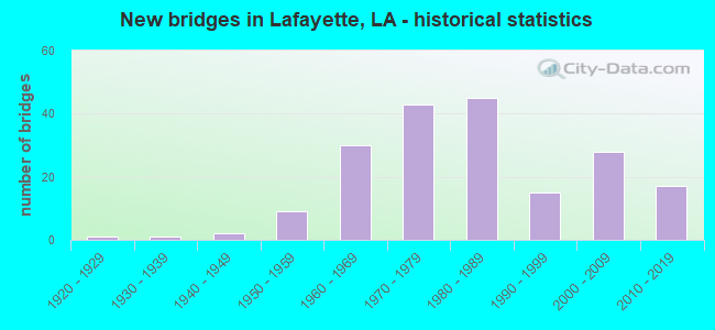
- New bridges - historical statistics
- 11920-1929
- 11930-1939
- 21940-1949
- 91950-1959
- 301960-1969
- 431970-1979
- 451980-1989
- 151990-1999
- 282000-2009
- 172010-2019
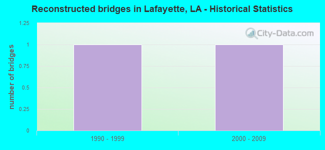
- Reconstructed bridges - Historical Statistics
- 11990-1999
- 12000-2009
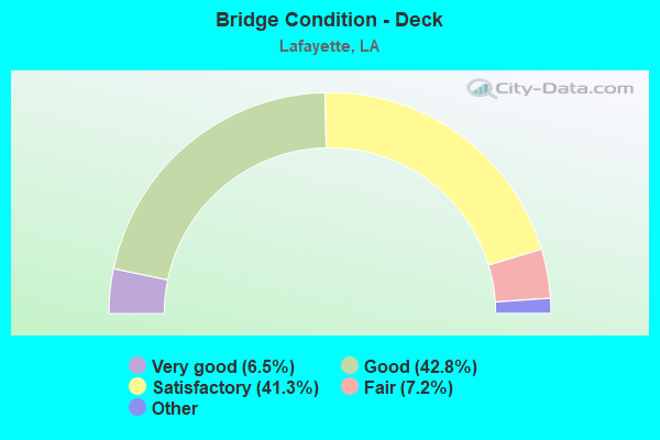
- Bridge Condition - Deck
- 6.5%Excellent
- 42.8%Very good
- 41.3%Good
- 7.2%Satisfactory
- 2.2%Fair
- 0.7%Poor
- 0.7%Failed
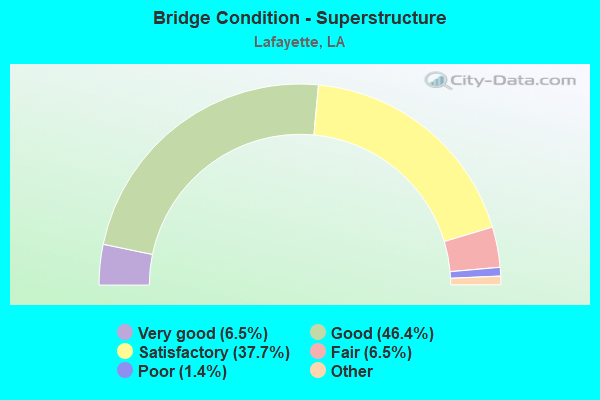
- Bridge Condition - Superstructure
- 6.5%Excellent
- 46.4%Very good
- 37.7%Good
- 6.5%Satisfactory
- 1.4%Fair
- 1.4%Poor
- 0.7%Failed
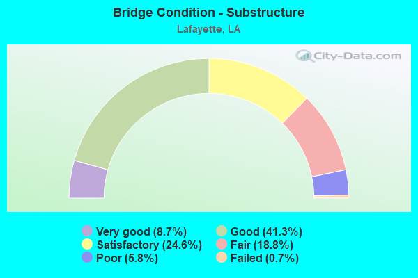
- Bridge Condition - Substructure
- 8.7%Very good
- 41.3%Good
- 24.6%Satisfactory
- 18.8%Fair
- 5.8%Poor
- 0.7%Failed
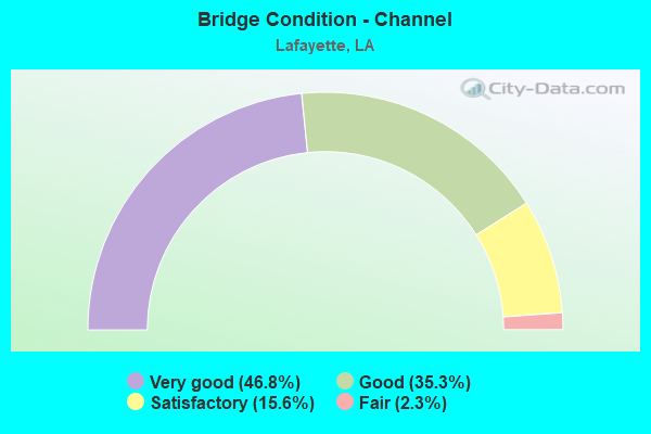
- Bridge Condition - Channel
- 46.8%Very good
- 35.3%Good
- 15.6%Satisfactory
- 2.3%Fair
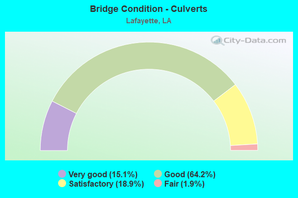
- Bridge Condition - Culverts
- 15.1%Very good
- 64.2%Good
- 18.9%Satisfactory
- 1.9%Fair
Find on map >> Show street view
Structure Number: 32830143920011, Location: 0.2 MI N OF LA 94 (Lat: 30.238069, Lng: -92.001669), Route carried "on" structure: County highway , Year Built: 1966, Status: Posted for load, Structure Length: 0.88m (2.89ft), Average Daily Traffic: 8,600 (year 2020), Average Future Daily Traffic: 21,141 (year 2040), Design Load: HS 20, Features Intersected: WEBB COULEE, Facility Carried by Structure: Louisiana Ave.
Minimum Vertical Clearance: 30+ m (98+ ft), Kilometerpoint: 0.000, Lanes on structure: 4, Owner: City or Municipal Highway Agency, Approaching Roadway Width: 18.9m (62.0ft), Skew: 30 degrees, Material/Design: Concrete, Design/Construction: Culvert, Number Of Spans In Main Unit: 2, Length of Maximum Span: 4.3m (14.1ft), Curb or Sidewalk Widths: Left: 1.5m (4.9ft), Right: 1.5m (4.9ft), Curb-To-Curb Width: 18.9m (62.0ft), Out-to-Out Width: 126.2m (414.0ft)
Condition: Channel: Very good, Culverts: Good, Operating Rating: 27.5 metric tons, Method Used To Determine Operating Rating: Load and Resistance Factor Rating (LRFR) rating reported by rating factor(RF) method using HL-93 loadings, Inventory Rating: 21.1 metric tons, Method Used To Determine Inventory Rating: Load and Resistance Factor Rating (LRFR) rating reported by rating factor(RF) method using HL-93 loadings, Structural Evaluation: Somewhat better than minimum adequacy, Deck Geometry: Equal to present minimum criteria, Waterway Adequacy: Equal to present desirable criteria, Approach Roadway Alignment: Better than present minimum criteria, Bridge Posting: Required (Relationship of Operating Rating to Maximum Legal Load: 10.0 - 19.9% below), Designated Inspection Frequency: Every 24 months, Inspection Date: January 2022, Deck Structure Type: Concrete Cast-file-Place
Find on map >> Show street view
Structure Number: 32830143920211, Location: 0.21 Mi W of LA 182 (Lat: 30.239300, Lng: -92.035950), Route carried "on" structure: County highway , Year Built: 1978, Status: Posted for load, Structure Length: 0.82m (2.69ft), Average Daily Traffic: 720 (year 2020), Average Future Daily Traffic: 1,770 (year 2040), Design Load: HS 20, Features Intersected: MINE BRANCH COULEE, Facility Carried by Structure: Madeline Ave.
Minimum Vertical Clearance: 30+ m (98+ ft), Kilometerpoint: 0.000, Lanes on structure: 2, Owner: City or Municipal Highway Agency, Approaching Roadway Width: 7.9m (25.9ft), Skew: 3 degrees, Material/Design: Concrete, Design/Construction: Culvert, Number Of Spans In Main Unit: 1, Length of Maximum Span: 7.9m (25.9ft), Curb or Sidewalk Widths: Left: 1.5m (4.9ft), Right: 1.5m (4.9ft), Curb-To-Curb Width: 7.6m (24.9ft), Out-to-Out Width: 13.6m (44.6ft)
Condition: Channel: Very good, Culverts: Good, Operating Rating: 29.5 metric tons, Method Used To Determine Operating Rating: Load and Resistance Factor Rating (LRFR) rating reported by rating factor(RF) method using HL-93 loadings, Inventory Rating: 22.7 metric tons, Method Used To Determine Inventory Rating: Load and Resistance Factor Rating (LRFR) rating reported by rating factor(RF) method using HL-93 loadings, Structural Evaluation: Equal to present minimum criteria, Deck Geometry: Meets minimum limits, Waterway Adequacy: Equal to present desirable criteria, Approach Roadway Alignment: High priority of corrective action, Bridge Posting: Required (Relationship of Operating Rating to Maximum Legal Load: 10.0 - 19.9% below), Length Of Structure Improvement: 1.43m (4.69ft), Designated Inspection Frequency: Every 24 months, Inspection Date: January 2022, Bridge Improvement Cost: $85,000, Total Project Cost: $127,000 ( Estimate for 2016), Deck Structure Type: Concrete Cast-file-Place
Find on map >> Show street view
Structure Number: 32830147920161, Location: 0.02 MI N of W. Willow St (Lat: 30.246011, Lng: -92.027039), Route carried "on" structure: County highway , Year Built: 1981, Status: Open, Structure Length: 1.74m (5.71ft), Average Daily Traffic: 1,201 (year 2020), Average Future Daily Traffic: 2,952 (year 2040), Design Load: HS 20, Features Intersected: COULEE MINE BRANCH, Facility Carried by Structure: Cora St.
Minimum Vertical Clearance: 30+ m (98+ ft), Kilometerpoint: 0.000, Lanes on structure: 2, Owner: City or Municipal Highway Agency, Approaching Roadway Width: 7.3m (24.0ft), Skew: 1 degrees, Material/Design: Concrete, Design/Construction: Slab, Number Of Spans In Main Unit: 3, Length of Maximum Span: 5.8m (19.0ft), Curb or Sidewalk Widths: Left: 0.0m, Right: 1.1m (3.6ft), Curb-To-Curb Width: 7.3m (24.0ft), Out-to-Out Width: 9.4m (30.8ft)
Condition: Deck: Good, Superstructure: Good, Substructure: Good, Channel: Very good, Operating Rating: 37.9 metric tons, Method Used To Determine Operating Rating: Load and Resistance Factor Rating (LRFR) rating reported by rating factor(RF) method using HL-93 loadings, Inventory Rating: 29.2 metric tons, Method Used To Determine Inventory Rating: Load and Resistance Factor Rating (LRFR) rating reported by rating factor(RF) method using HL-93 loadings, Structural Evaluation: Better than present minimum criteria, Deck Geometry: Meets minimum limits, Waterway Adequacy: Equal to present desirable criteria, Approach Roadway Alignment: High priority of corrective action, Designated Inspection Frequency: Every 24 months, Inspection Date: January 2022, Deck Structure Type: Concrete Precast Panels, Wearing Surface/Protective System: Wearing Surface: Bituminous
Find on map >> Show street view
Structure Number: 32830155915961, Location: 0.97 Mi S of I-10 (Lat: 30.260100, Lng: -91.994950), Route carried "on" structure: County highway , Year Built: 1979, Status: Open, Structure Length: 3.05m (10.01ft), Average Daily Traffic: 370 (year 2020), Average Future Daily Traffic: 910 (year 2040), Design Load: HS 20, Features Intersected: DRAINAGE, Facility Carried by Structure: Shadow Bluff Dr
Minimum Vertical Clearance: 30+ m (98+ ft), Kilometerpoint: 0.000, Lanes on structure: 2, Owner: City or Municipal Highway Agency, Approaching Roadway Width: 6.7m (22.0ft), Skew: 5 degrees, Material/Design: Steel, Design/Construction: Stringer/Multi-beam, Number Of Spans In Main Unit: 3, Length of Maximum Span: 18.3m (60.0ft), Curb or Sidewalk Widths: Left: 1.2m (3.9ft), Right: 1.2m (3.9ft), Curb-To-Curb Width: 8.5m (27.9ft), Out-to-Out Width: 11.6m (38.1ft)
Condition: Deck: Satisfactory, Superstructure: Satisfactory, Substructure: Good, Channel: Very good, Operating Rating: 39.9 metric tons, Method Used To Determine Operating Rating: Load Factor (LF), Inventory Rating: 30.8 metric tons, Method Used To Determine Inventory Rating: Load Factor (LF), Structural Evaluation: Equal to present minimum criteria, Deck Geometry: Equal to present minimum criteria, Waterway Adequacy: Equal to present desirable criteria, Approach Roadway Alignment: Equal to present minimum criteria, Designated Inspection Frequency: Every 24 months, Inspection Date: October 2021, Deck Structure Type: Concrete Cast-file-Place, Wearing Surface/Protective System: Wearing Surface: Bituminous
Find on map >> Show street view
Structure Number: 32830157915981, Location: 0.57 Mi S of I-10 (Lat: 30.261231, Lng: -91.995531), Route carried "on" structure: County highway , Year Built: 2004, Status: Open, Structure Length: 4.57m (14.99ft), Average Daily Traffic: 4,250 (year 2020), Average Future Daily Traffic: 10,448 (year 2040), Design Load: HS 20, Features Intersected: COULEE, Facility Carried by Structure: Louisiana Ave.
Minimum Vertical Clearance: 30+ m (98+ ft), Kilometerpoint: 0.000, Lanes on structure: 2, Owner: County Highway Agency, Approaching Roadway Width: 7.9m (25.9ft), Skew: 2 degrees, Material/Design: Prestressed concrete continuous, Design/Construction: Stringer/Multi-beam, Number Of Spans In Main Unit: 3, Length of Maximum Span: 15.2m (49.9ft), Curb or Sidewalk Widths: Left: 0.0m, Right: 2.2m (7.2ft), Curb-To-Curb Width: 9.1m (29.9ft), Out-to-Out Width: 12.3m (40.4ft)
Condition: Deck: Good, Superstructure: Good, Substructure: Good, Channel: Good, Operating Rating: 74.4 metric tons, Method Used To Determine Operating Rating: Load Factor (LF), Inventory Rating: 48.1 metric tons, Method Used To Determine Inventory Rating: Load Factor (LF), Structural Evaluation: Better than present minimum criteria, Deck Geometry: Meets minimum limits, Waterway Adequacy: Better than present minimum criteria, Approach Roadway Alignment: Equal to present desirable criteria, Designated Inspection Frequency: Every 24 months, Inspection Date: October 2021, Deck Structure Type: Concrete Cast-file-Place
Find on map >> Show street view
Structure Number: 32830157915982, Location: 0.57 Mi S of I-10 (Lat: 30.260931, Lng: -91.995811), Route carried "on" structure: County highway , Year Built: 2004, Status: Open, Structure Length: 4.57m (14.99ft), Average Daily Traffic: 4,675 (year 2020), Average Future Daily Traffic: 11,493 (year 2040), Design Load: HS 20, Features Intersected: COULEE, Facility Carried by Structure: Louisiana Ave.
Minimum Vertical Clearance: 30+ m (98+ ft), Kilometerpoint: 0.000, Lanes on structure: 2, Owner: County Highway Agency, Approaching Roadway Width: 7.9m (25.9ft), Skew: 2 degrees, Material/Design: Prestressed concrete continuous, Design/Construction: Stringer/Multi-beam, Number Of Spans In Main Unit: 3, Length of Maximum Span: 15.2m (49.9ft), Curb or Sidewalk Widths: Left: 2.2m (7.2ft), Right: 0.0m, Curb-To-Curb Width: 9.1m (29.9ft), Out-to-Out Width: 12.3m (40.4ft)
Condition: Deck: Good, Superstructure: Good, Substructure: Good, Channel: Good, Operating Rating: 74.4 metric tons, Method Used To Determine Operating Rating: Load Factor (LF), Inventory Rating: 48.1 metric tons, Method Used To Determine Inventory Rating: Load Factor (LF), Structural Evaluation: Better than present minimum criteria, Deck Geometry: Meets minimum limits, Waterway Adequacy: Better than present minimum criteria, Approach Roadway Alignment: Equal to present desirable criteria, Designated Inspection Frequency: Every 24 months, Inspection Date: October 2021, Deck Structure Type: Concrete Cast-file-Place
Find on map >> Show street view
Structure Number: 32830158915981, Location: 0.70 Mi SW of I-10 (Lat: 30.264011, Lng: -91.998081), Route carried "on" structure: County highway , Year Built: 1999, Status: Open, Structure Length: 2.90m (9.51ft), Average Daily Traffic: 475 (year 2022), Average Future Daily Traffic: 523 (year 2036), Design Load: HS 20, Features Intersected: COULEE, Facility Carried by Structure: Daigle St.
Minimum Vertical Clearance: 30+ m (98+ ft), Kilometerpoint: 0.000, Lanes on structure: 2, Owner: County Highway Agency, Approaching Roadway Width: 6.7m (22.0ft), Material/Design: Concrete, Design/Construction: Slab, Number Of Spans In Main Unit: 5, Length of Maximum Span: 5.8m (19.0ft), Curb-To-Curb Width: 8.5m (27.9ft), Out-to-Out Width: 9.3m (30.5ft)
Condition: Deck: Good, Superstructure: Good, Substructure: Satisfactory, Channel: Very good, Operating Rating: 54.8 metric tons, Method Used To Determine Operating Rating: Load and Resistance Factor Rating (LRFR) rating reported by rating factor(RF) method using HL-93 loadings, Inventory Rating: 42.1 metric tons, Method Used To Determine Inventory Rating: Load and Resistance Factor Rating (LRFR) rating reported by rating factor(RF) method using HL-93 loadings, Structural Evaluation: Equal to present minimum criteria, Deck Geometry: Somewhat better than minimum adequacy, Waterway Adequacy: Equal to present desirable criteria, Approach Roadway Alignment: Equal to present desirable criteria, Designated Inspection Frequency: Every 24 months, Inspection Date: January 2022, Deck Structure Type: Concrete Precast Panels
Find on map >> Show street view
Structure Number: 32830158920101, Location: 0.75 Mi SW of I-49 (Lat: 30.263261, Lng: -92.018400), Route carried "on" structure: County highway , Year Built: 1984, Status: Posted for load, Structure Length: 1.83m (6.00ft), Average Daily Traffic: 1,400 (year 2020), Average Future Daily Traffic: 3,442 (year 2040), Design Load: HS 20, Features Intersected: DRAINAGE CANAL, Facility Carried by Structure: Acadian Hills Ln.
Minimum Vertical Clearance: 30+ m (98+ ft), Kilometerpoint: 0.000, Lanes on structure: 2, Owner: City or Municipal Highway Agency, Approaching Roadway Width: 7.5m (24.6ft), Material/Design: Concrete, Design/Construction: Slab, Number Of Spans In Main Unit: 3, Length of Maximum Span: 5.8m (19.0ft), Curb-To-Curb Width: 7.5m (24.6ft), Out-to-Out Width: 8.6m (28.2ft)
Condition: Deck: Satisfactory, Superstructure: Satisfactory, Substructure: Fair, Channel: Good, Operating Rating: 22.7 metric tons, Method Used To Determine Operating Rating: Load and Resistance Factor Rating (LRFR) rating reported by rating factor(RF) method using HL-93 loadings, Inventory Rating: 17.2 metric tons, Method Used To Determine Inventory Rating: Load and Resistance Factor Rating (LRFR) rating reported by rating factor(RF) method using HL-93 loadings, Structural Evaluation: Meets minimum limits, Deck Geometry: Meets minimum limits, Waterway Adequacy: Better than present minimum criteria, Approach Roadway Alignment: Equal to present desirable criteria, Bridge Posting: Required (Relationship of Operating Rating to Maximum Legal Load: 10.0 - 19.9% below), Designated Inspection Frequency: Every 24 months, Inspection Date: October 2021, Deck Structure Type: Concrete Cast-file-Place
Find on map >> Show street view
Structure Number: 32830162920221, Location: 1.23 MI SE of LA 182 (Lat: 30.269911, Lng: -92.034111), Route carried "on" structure: County highway , Year Built: 1985, Status: Open, Structure Length: 1.77m (5.81ft), Average Daily Traffic: 211 (year 2020), Average Future Daily Traffic: 519 (year 2040), Design Load: HS 20, Features Intersected: COULEE, Facility Carried by Structure: Laser Ln.
Minimum Vertical Clearance: 30+ m (98+ ft), Kilometerpoint: 0.000, Lanes on structure: 2, Owner: City or Municipal Highway Agency, Approaching Roadway Width: 7.6m (24.9ft), Material/Design: Concrete, Design/Construction: Slab, Number Of Spans In Main Unit: 3, Length of Maximum Span: 5.8m (19.0ft), Curb-To-Curb Width: 7.3m (24.0ft), Out-to-Out Width: 8.1m (26.6ft)
Condition: Deck: Good, Superstructure: Good, Substructure: Fair, Channel: Satisfactory, Operating Rating: 32.4 metric tons, Method Used To Determine Operating Rating: Load and Resistance Factor Rating (LRFR) rating reported by rating factor(RF) method using HL-93 loadings, Inventory Rating: 24.9 metric tons, Method Used To Determine Inventory Rating: Load and Resistance Factor Rating (LRFR) rating reported by rating factor(RF) method using HL-93 loadings, Structural Evaluation: Somewhat better than minimum adequacy, Deck Geometry: Somewhat better than minimum adequacy, Waterway Adequacy: Equal to present desirable criteria, Approach Roadway Alignment: Equal to present minimum criteria, Designated Inspection Frequency: Every 24 months, Inspection Date: January 2022, Deck Structure Type: Concrete Cast-file-Place, Wearing Surface/Protective System: Wearing Surface: Bituminous
Find on map >> Show street view
Structure Number: 32830163915901, Location: 1.3 MI E OF LA 728-1 (Lat: 30.271969, Lng: -91.983800), Route carried "on" structure: County highway , Year Built: 1986, Status: Open, Structure Length: 4.88m (16.01ft), Average Daily Traffic: 2,530 (year 2020), Average Future Daily Traffic: 6,219 (year 2040), Design Load: HS 20, Features Intersected: VERMILION RIVER, Facility Carried by Structure: E. Pont Des Mouton
Minimum Vertical Clearance: 30+ m (98+ ft), Kilometerpoint: 0.000, Lanes on structure: 2, Owner: County Highway Agency, Approaching Roadway Width: 5.8m (19.0ft), Material/Design: Concrete, Design/Construction: Slab, Number Of Spans In Main Unit: 8, Length of Maximum Span: 6.1m (20.0ft), Curb-To-Curb Width: 13.4m (44.0ft), Out-to-Out Width: 14.3m (46.9ft)
Condition: Deck: Good, Superstructure: Good, Substructure: Good, Channel: Very good, Operating Rating: 33.0 metric tons, Method Used To Determine Operating Rating: Load and Resistance Factor Rating (LRFR) rating reported by rating factor(RF) method using HL-93 loadings, Inventory Rating: 25.6 metric tons, Method Used To Determine Inventory Rating: Load and Resistance Factor Rating (LRFR) rating reported by rating factor(RF) method using HL-93 loadings, Structural Evaluation: Equal to present minimum criteria, Deck Geometry: Better than present minimum criteria, Waterway Adequacy: Better than present minimum criteria, Approach Roadway Alignment: High priority of corrective action, Designated Inspection Frequency: Every 24 months, Underwater Inspection Frequency: Every 60 months, Inspection Date: October 2021, Underwater Inspection Date: July 2018, Deck Structure Type: Concrete Cast-file-Place
Find on map >> Show street view
Structure Number: 32830164920131, Location: 0.03 MI. W. US 167 (Lat: 30.273661, Lng: -92.021661), Route carried "on" structure: County highway , Year Built: 1962, Year Reconstructed: 2006, Status: Posted for load, Structure Length: 1.19m (3.90ft), Average Daily Traffic: 8,400 (year 2020), Average Future Daily Traffic: 20,650 (year 2040), Design Load: HS 20, Features Intersected: FRANCOIS COULEE, Facility Carried by Structure: W. Pont Des Mouton
Minimum Vertical Clearance: 30+ m (98+ ft), Kilometerpoint: 0.000, Lanes on structure: 2, Owner: City or Municipal Highway Agency, Approaching Roadway Width: 13.4m (44.0ft), Skew: 1 degrees, Material/Design: Concrete, Design/Construction: Culvert, Number Of Spans In Main Unit: 3, Length of Maximum Span: 4.0m (13.1ft), Out-to-Out Width: 37.8m (124.0ft)
Condition: Channel: Satisfactory, Culverts: Good, Operating Rating: 42.1 metric tons, Method Used To Determine Operating Rating: Load and Resistance Factor Rating (LRFR) rating reported by rating factor(RF) method using HL-93 loadings, Inventory Rating: 32.4 metric tons, Method Used To Determine Inventory Rating: Load and Resistance Factor Rating (LRFR) rating reported by rating factor(RF) method using HL-93 loadings, Structural Evaluation: Better than present minimum criteria, Waterway Adequacy: Equal to present minimum criteria, Approach Roadway Alignment: Equal to present desirable criteria, Designated Inspection Frequency: Every 24 months, Inspection Date: January 2022, Deck Structure Type: Concrete Cast-file-Place
Find on map >> Show street view
Structure Number: 32830164920211, Location: 1.07 Mi W of I-49 (Lat: 30.274339, Lng: -92.036319), Route carried "on" structure: County highway , Year Built: 2007, Status: Posted for load, Structure Length: 0.73m (2.40ft), Average Daily Traffic: 5,584 (year 2020), Average Future Daily Traffic: 13,727 (year 2040), Design Load: HS 20, Features Intersected: CANAL, Facility Carried by Structure: W. Pont Des Mouton
Minimum Vertical Clearance: 30+ m (98+ ft), Kilometerpoint: 0.000, Lanes on structure: 4, Owner: County Highway Agency, Approaching Roadway Width: 15.9m (52.2ft), Skew: 34 degrees, Material/Design: Concrete, Design/Construction: Culvert, Number Of Spans In Main Unit: 1, Length of Maximum Span: 7.3m (24.0ft), Curb-To-Curb Width: 7.9m (25.9ft), Out-to-Out Width: 30.8m (101.0ft)
Condition: Channel: Very good, Culverts: Good, Operating Rating: 34.7 metric tons, Method Used To Determine Operating Rating: Load and Resistance Factor Rating (LRFR) rating reported by rating factor(RF) method using HL-93 loadings, Inventory Rating: 29.8 metric tons, Method Used To Determine Inventory Rating: Load and Resistance Factor Rating (LRFR) rating reported by rating factor(RF) method using HL-93 loadings, Structural Evaluation: Better than present minimum criteria, Deck Geometry: High priority of replacement, Waterway Adequacy: Equal to present desirable criteria, Approach Roadway Alignment: Equal to present desirable criteria, Bridge Posting: Required (Relationship of Operating Rating to Maximum Legal Load: 20.0 - 29.9% below), Designated Inspection Frequency: Every 24 months, Inspection Date: January 2022, Deck Structure Type: Other
Find on map >> Show street view
Structure Number: 32830166920301, Location: 0.02 Mi E of LA 182 (Lat: 30.277631, Lng: -92.049531), Route carried "on" structure: County highway , Year Built: 1984, Status: Posted for load, Structure Length: 1.19m (3.90ft), Average Daily Traffic: 400 (year 2020), Average Future Daily Traffic: 983 (year 2040), Design Load: HS 20, Features Intersected: GASTON COULEE, Facility Carried by Structure: Birdsong Rd.
Minimum Vertical Clearance: 30+ m (98+ ft), Kilometerpoint: 0.000, Lanes on structure: 2, Owner: County Highway Agency, Approaching Roadway Width: 6.4m (21.0ft), Material/Design: Concrete, Design/Construction: Slab, Number Of Spans In Main Unit: 2, Length of Maximum Span: 5.8m (19.0ft), Curb-To-Curb Width: 7.4m (24.3ft), Out-to-Out Width: 8.2m (26.9ft)
Condition: Deck: Satisfactory, Superstructure: Satisfactory, Substructure: Good, Channel: Good, Operating Rating: 21.1 metric tons, Method Used To Determine Operating Rating: Load and Resistance Factor Rating (LRFR) rating reported by rating factor(RF) method using HL-93 loadings, Inventory Rating: 16.2 metric tons, Method Used To Determine Inventory Rating: Load and Resistance Factor Rating (LRFR) rating reported by rating factor(RF) method using HL-93 loadings, Structural Evaluation: Somewhat better than minimum adequacy, Deck Geometry: Somewhat better than minimum adequacy, Waterway Adequacy: Equal to present desirable criteria, Approach Roadway Alignment: Equal to present desirable criteria, Bridge Posting: Required (Relationship of Operating Rating to Maximum Legal Load: 20.0 - 29.9% below), Designated Inspection Frequency: Every 24 months, Inspection Date: October 2021, Deck Structure Type: Concrete Cast-file-Place, Wearing Surface/Protective System: Wearing Surface: Bituminous
Find on map >> Show street view
Structure Number: 32830167915891, Location: 0.56 Mi N of i-10 (Lat: 30.278011, Lng: -91.982789), Route carried "on" structure: County highway , Year Built: 1977, Status: Posted for load, Structure Length: 4.05m (13.29ft), Average Daily Traffic: 340 (year 2020), Average Future Daily Traffic: 836 (year 2040), Design Load: HS 20, Features Intersected: VERMILION RIVER, Facility Carried by Structure: Maryview Farm Rd.
Minimum Vertical Clearance: 30+ m (98+ ft), Kilometerpoint: 0.000, Lanes on structure: 2, Owner: City or Municipal Highway Agency, Approaching Roadway Width: 6.9m (22.6ft), Material/Design: Concrete, Design/Construction: Slab, Number Of Spans In Main Unit: 7, Length of Maximum Span: 5.8m (19.0ft), Curb-To-Curb Width: 7.3m (24.0ft), Out-to-Out Width: 8.3m (27.2ft)
Condition: Deck: Fair, Superstructure: Fair, Substructure: Satisfactory, Channel: Satisfactory, Operating Rating: 21.4 metric tons, Method Used To Determine Operating Rating: Load and Resistance Factor Rating (LRFR) rating reported by rating factor(RF) method using HL-93 loadings, Inventory Rating: 17.5 metric tons, Method Used To Determine Inventory Rating: Load and Resistance Factor Rating (LRFR) rating reported by rating factor(RF) method using HL-93 loadings, Structural Evaluation: Somewhat better than minimum adequacy, Deck Geometry: Somewhat better than minimum adequacy, Waterway Adequacy: Equal to present desirable criteria, Approach Roadway Alignment: High priority of corrective action, Bridge Posting: Required (Relationship of Operating Rating to Maximum Legal Load: 20.0 - 29.9% below), Designated Inspection Frequency: Every 24 months, Underwater Inspection Frequency: Every 60 months, Inspection Date: January 2022, Underwater Inspection Date: July 2018, Deck Structure Type: Concrete Cast-file-Place
Find on map >> Show street view
Structure Number: 32830167915911, Location: 1.15 Mi NE of I-10 (Lat: 30.278331, Lng: -91.984650), Route carried "on" structure: County highway , Year Built: 1986, Status: Open, Structure Length: 1.74m (5.71ft), Average Daily Traffic: 340 (year 2020), Average Future Daily Traffic: 836 (year 2040), Design Load: HS 20, Features Intersected: MANOR PARK COULEE, Facility Carried by Structure: Maryview Farm Rd
Minimum Vertical Clearance: 30+ m (98+ ft), Kilometerpoint: 0.000, Lanes on structure: 2, Owner: City or Municipal Highway Agency, Approaching Roadway Width: 6.2m (20.3ft), Skew: 7 degrees, Material/Design: Concrete, Design/Construction: Slab, Number Of Spans In Main Unit: 3, Length of Maximum Span: 5.8m (19.0ft), Curb-To-Curb Width: 7.3m (24.0ft), Out-to-Out Width: 8.2m (26.9ft)
Condition: Deck: Satisfactory, Superstructure: Satisfactory, Substructure: Satisfactory, Channel: Very good, Operating Rating: 47.6 metric tons, Method Used To Determine Operating Rating: Load and Resistance Factor Rating (LRFR) rating reported by rating factor(RF) method using HL-93 loadings, Inventory Rating: 36.9 metric tons, Method Used To Determine Inventory Rating: Load and Resistance Factor Rating (LRFR) rating reported by rating factor(RF) method using HL-93 loadings, Structural Evaluation: Equal to present minimum criteria, Deck Geometry: Somewhat better than minimum adequacy, Waterway Adequacy: Equal to present desirable criteria, Approach Roadway Alignment: Equal to present desirable criteria, Designated Inspection Frequency: Every 24 months, Inspection Date: January 2022, Deck Structure Type: Concrete Cast-file-Place
Find on map >> Show street view
Structure Number: 32830167915961, Location: 0.75 Mi N of I-10 (Lat: 30.278731, Lng: -91.993300), Route carried "on" structure: County highway , Year Built: 2006, Status: Open, Structure Length: 2.32m (7.61ft), Average Daily Traffic: 752 (year 2020), Average Future Daily Traffic: 1,849 (year 2040), Design Load: HS 20, Features Intersected: DRAIN, Facility Carried by Structure: Maryview Farm Rd.
Minimum Vertical Clearance: 30+ m (98+ ft), Kilometerpoint: 0.000, Lanes on structure: 2, Owner: County Highway Agency, Approaching Roadway Width: 6.4m (21.0ft), Skew: 7 degrees, Material/Design: Concrete, Design/Construction: Slab, Number Of Spans In Main Unit: 4, Length of Maximum Span: 5.8m (19.0ft), Curb or Sidewalk Widths: Left: 2.0m (6.6ft), Right: 2.0m (6.6ft), Curb-To-Curb Width: 12.2m (40.0ft), Out-to-Out Width: 16.9m (55.4ft)
Condition: Deck: Good, Superstructure: Good, Substructure: Satisfactory, Channel: Very good, Operating Rating: 48.6 metric tons, Method Used To Determine Operating Rating: Load and Resistance Factor Rating (LRFR) rating reported by rating factor(RF) method using HL-93 loadings, Inventory Rating: 37.6 metric tons, Method Used To Determine Inventory Rating: Load and Resistance Factor Rating (LRFR) rating reported by rating factor(RF) method using HL-93 loadings, Structural Evaluation: Equal to present minimum criteria, Deck Geometry: Equal to present desirable criteria, Waterway Adequacy: Equal to present desirable criteria, Approach Roadway Alignment: Equal to present desirable criteria, Designated Inspection Frequency: Every 24 months, Inspection Date: October 2021, Deck Structure Type: Concrete Precast Panels
Find on map >> Show street view
Structure Number: 32830168920111, Location: 0.08 Mi E0. of I-49 (Lat: 30.280961, Lng: -92.019311), Route carried "on" structure: County highway , Year Built: 1974, Status: Open, Structure Length: 1.16m (3.81ft), Average Daily Traffic: 1,000 (year 2020), Average Future Daily Traffic: 2,458 (year 2040), Design Load: HS 20, Features Intersected: COULEE, Facility Carried by Structure: High Meadow Blvd
Minimum Vertical Clearance: 30+ m (98+ ft), Kilometerpoint: 0.000, Lanes on structure: 2, Owner: City or Municipal Highway Agency, Approaching Roadway Width: 5.5m (18.0ft), Skew: 4 degrees, Material/Design: Concrete, Design/Construction: Slab, Number Of Spans In Main Unit: 2, Length of Maximum Span: 5.8m (19.0ft), Curb-To-Curb Width: 7.4m (24.3ft), Out-to-Out Width: 8.3m (27.2ft)
Condition: Deck: Satisfactory, Superstructure: Satisfactory, Substructure: Fair, Channel: Good, Operating Rating: 46.3 metric tons, Method Used To Determine Operating Rating: Load and Resistance Factor Rating (LRFR) rating reported by rating factor(RF) method using HL-93 loadings, Inventory Rating: 35.6 metric tons, Method Used To Determine Inventory Rating: Load and Resistance Factor Rating (LRFR) rating reported by rating factor(RF) method using HL-93 loadings, Structural Evaluation: Somewhat better than minimum adequacy, Deck Geometry: High priority of replacement, Waterway Adequacy: Better than present minimum criteria, Approach Roadway Alignment: High priority of corrective action, Length Of Structure Improvement: 1.89m (6.20ft), Designated Inspection Frequency: Every 24 months, Inspection Date: January 2022, Bridge Improvement Cost: $112,000, Total Project Cost: $168,000 ( Estimate for 2016), Deck Structure Type: Concrete Cast-file-Place
Find on map >> Show street view
Structure Number: 32830169915841, Location: 1.4 Mi NW of I-10 (Lat: 30.284069, Lng: -91.972731), Route carried "on" structure: County highway , Year Built: 1978, Status: Posted for load, Structure Length: 1.77m (5.81ft), Average Daily Traffic: 1,160 (year 2020), Average Future Daily Traffic: 2,851 (year 2040), Design Load: HS 20, Features Intersected: COULEE, Facility Carried by Structure: Lajaunie Rd
Minimum Vertical Clearance: 30+ m (98+ ft), Kilometerpoint: 0.000, Lanes on structure: 2, Owner: County Highway Agency, Approaching Roadway Width: 6.4m (21.0ft), Material/Design: Concrete, Design/Construction: Slab, Number Of Spans In Main Unit: 3, Length of Maximum Span: 5.8m (19.0ft), Curb-To-Curb Width: 7.4m (24.3ft), Out-to-Out Width: 8.3m (27.2ft)
Condition: Deck: Satisfactory, Superstructure: Satisfactory, Substructure: Fair, Channel: Fair, Operating Rating: 22.0 metric tons, Method Used To Determine Operating Rating: Load and Resistance Factor Rating (LRFR) rating reported by rating factor(RF) method using HL-93 loadings, Inventory Rating: 16.8 metric tons, Method Used To Determine Inventory Rating: Load and Resistance Factor Rating (LRFR) rating reported by rating factor(RF) method using HL-93 loadings, Structural Evaluation: Meets minimum limits, Deck Geometry: Meets minimum limits, Waterway Adequacy: Equal to present minimum criteria, Approach Roadway Alignment: Equal to present minimum criteria, Bridge Posting: Required (Relationship of Operating Rating to Maximum Legal Load: 30.0 - 39.9% below), Length Of Structure Improvement: 2.47m (8.10ft), Designated Inspection Frequency: Every 24 months, Underwater Inspection Frequency: Every 60 months, Other Special Inspection Frequency: Every 12 months, Inspection Date: January 2022, Underwater Inspection Date: January 2019, Other Special Inspection Date: January 2021, Bridge Improvement Cost: $147,000, Total Project Cost: $220,000 ( Estimate for 2016), Deck Structure Type: Concrete Cast-file-Place
Find on map >> Show street view
Structure Number: 32830169920101, Location: 0.2 Mi E of I-49 (Lat: 30.281750, Lng: -92.017669), Route carried "on" structure: County highway , Year Built: 1974, Status: Posted for load, Structure Length: 1.16m (3.81ft), Average Daily Traffic: 1,100 (year 2020), Average Future Daily Traffic: 2,704 (year 2040), Design Load: HS 20, Features Intersected: COULEE, Facility Carried by Structure: High Meadow Blvd
Minimum Vertical Clearance: 30+ m (98+ ft), Kilometerpoint: 0.000, Lanes on structure: 2, Owner: City or Municipal Highway Agency, Approaching Roadway Width: 5.5m (18.0ft), Skew: 4 degrees, Material/Design: Concrete, Design/Construction: Slab, Number Of Spans In Main Unit: 2, Length of Maximum Span: 5.8m (19.0ft), Curb-To-Curb Width: 7.4m (24.3ft), Out-to-Out Width: 8.3m (27.2ft)
Condition: Deck: Satisfactory, Superstructure: Satisfactory, Substructure: Poor, Channel: Good, Operating Rating: 49.2 metric tons, Method Used To Determine Operating Rating: Load and Resistance Factor Rating (LRFR) rating reported by rating factor(RF) method using HL-93 loadings, Inventory Rating: 37.9 metric tons, Method Used To Determine Inventory Rating: Load and Resistance Factor Rating (LRFR) rating reported by rating factor(RF) method using HL-93 loadings, Structural Evaluation: Meets minimum limits, Deck Geometry: High priority of replacement, Waterway Adequacy: Equal to present desirable criteria, Approach Roadway Alignment: High priority of corrective action, Bridge Posting: Required (Relationship of Operating Rating to Maximum Legal Load: 20.0 - 29.9% below), Length Of Structure Improvement: 1.89m (6.20ft), Designated Inspection Frequency: Every 24 months, Other Special Inspection Frequency: Every 12 months, Inspection Date: January 2022, Other Special Inspection Date: January 2021, Bridge Improvement Cost: $112,000, Total Project Cost: $168,000 ( Estimate for 2016), Deck Structure Type: Concrete Cast-file-Place
Find on map >> Show street view
Structure Number: 32830172915911, Location: 2.20 Mi E of I-49 (Lat: 30.285850, Lng: -91.985681), Route carried "on" structure: County highway , Year Built: 1984, Status: Open, Structure Length: 1.77m (5.81ft), Average Daily Traffic: 224 (year 2020), Average Future Daily Traffic: 551 (year 2040), Design Load: HS 20, Features Intersected: DRAINAGE COULEE, Facility Carried by Structure: E. Butcher Switch
Minimum Vertical Clearance: 30+ m (98+ ft), Kilometerpoint: 0.000, Lanes on structure: 2, Owner: County Highway Agency, Approaching Roadway Width: 5.8m (19.0ft), Material/Design: Concrete, Design/Construction: Slab, Number Of Spans In Main Unit: 3, Length of Maximum Span: 5.8m (19.0ft), Curb-To-Curb Width: 7.3m (24.0ft), Out-to-Out Width: 8.7m (28.5ft)
Condition: Deck: Fair, Superstructure: Fair, Substructure: Fair, Channel: Good, Operating Rating: 53.5 metric tons, Method Used To Determine Operating Rating: Load Factor (LF), Inventory Rating: 32.7 metric tons, Method Used To Determine Inventory Rating: Load Factor (LF), Structural Evaluation: Somewhat better than minimum adequacy, Deck Geometry: Somewhat better than minimum adequacy, Waterway Adequacy: Better than present minimum criteria, Approach Roadway Alignment: Equal to present desirable criteria, Designated Inspection Frequency: Every 24 months, Inspection Date: October 2021, Deck Structure Type: Concrete Cast-file-Place
Find on map >> Show street view
Structure Number: 32830172915951, Location: 1.80Mi E of I-49 (Lat: 30.286181, Lng: -91.992481), Route carried "on" structure: County highway , Year Built: 2006, Status: Open, Structure Length: 1.74m (5.71ft), Average Daily Traffic: 1,003 (year 2020), Average Future Daily Traffic: 2,466 (year 2040), Design Load: HS 20, Features Intersected: OAK COULEE, Facility Carried by Structure: E. Butcher Switch
Minimum Vertical Clearance: 30+ m (98+ ft), Kilometerpoint: 0.000, Lanes on structure: 2, Owner: County Highway Agency, Approaching Roadway Width: 6.6m (21.7ft), Skew: 9 degrees, Material/Design: Concrete, Design/Construction: Slab, Number Of Spans In Main Unit: 3, Length of Maximum Span: 5.8m (19.0ft), Curb-To-Curb Width: 8.5m (27.9ft), Out-to-Out Width: 9.7m (31.8ft)
Condition: Deck: Good, Superstructure: Good, Substructure: Satisfactory, Channel: Very good, Operating Rating: 59.0 metric tons, Method Used To Determine Operating Rating: Load Factor (LF), Inventory Rating: 34.5 metric tons, Method Used To Determine Inventory Rating: Load Factor (LF), Structural Evaluation: Equal to present minimum criteria, Deck Geometry: Somewhat better than minimum adequacy, Waterway Adequacy: Equal to present desirable criteria, Approach Roadway Alignment: Equal to present desirable criteria, Designated Inspection Frequency: Every 24 months, Inspection Date: October 2021, Deck Structure Type: Concrete Cast-file-Place, Wearing Surface/Protective System: Wearing Surface: Bituminous
Find on map >> Show street view
Structure Number: 32830173920021, Location: 0.58 Mi E of I-49 (Lat: 30.287131, Lng: -92.012769), Route carried "on" structure: County highway , Year Built: 1981, Status: Posted for load, Structure Length: 1.16m (3.81ft), Average Daily Traffic: 1,122 (year 2020), Average Future Daily Traffic: 2,758 (year 2040), Design Load: HS 20, Features Intersected: DRAINAGE COULEE, Facility Carried by Structure: E. Butcher Switch
Minimum Vertical Clearance: 30+ m (98+ ft), Kilometerpoint: 0.000, Lanes on structure: 2, Owner: City or Municipal Highway Agency, Approaching Roadway Width: 6.9m (22.6ft), Material/Design: Concrete, Design/Construction: Slab, Number Of Spans In Main Unit: 2, Length of Maximum Span: 5.8m (19.0ft), Curb-To-Curb Width: 7.4m (24.3ft), Out-to-Out Width: 8.4m (27.6ft)
Condition: Deck: Satisfactory, Superstructure: Satisfactory, Substructure: Satisfactory, Channel: Good, Operating Rating: 24.9 metric tons, Method Used To Determine Operating Rating: Load and Resistance Factor Rating (LRFR) rating reported by rating factor(RF) method using HL-93 loadings, Inventory Rating: 19.4 metric tons, Method Used To Determine Inventory Rating: Load and Resistance Factor Rating (LRFR) rating reported by rating factor(RF) method using HL-93 loadings, Structural Evaluation: Somewhat better than minimum adequacy, Deck Geometry: Meets minimum limits, Waterway Adequacy: Equal to present desirable criteria, Approach Roadway Alignment: Equal to present desirable criteria, Bridge Posting: Required (Relationship of Operating Rating to Maximum Legal Load: 0.1 - 9.9% below), Designated Inspection Frequency: Every 24 months, Inspection Date: October 2021, Deck Structure Type: Concrete Precast Panels, Wearing Surface/Protective System: Wearing Surface: Monolithic Concrete
Find on map >> Show street view
Structure Number: 32830173920341, Location: 0.5M WEST OF LA 182 (Lat: 30.290531, Lng: -92.058519), Route carried "on" structure: County highway , Year Built: 1991, Status: Open, Structure Length: 1.22m (4.00ft), Average Daily Traffic: 780 (year 2020), Average Future Daily Traffic: 1,917 (year 2040), Design Load: HS 20, Features Intersected: MIMS COULEE, Facility Carried by Structure: Malapart Rd.
Minimum Vertical Clearance: 30+ m (98+ ft), Kilometerpoint: 0.000, Lanes on structure: 2, Owner: County Highway Agency, Approaching Roadway Width: 5.9m (19.4ft), Skew: 2 degrees, Material/Design: Concrete, Design/Construction: Slab, Number Of Spans In Main Unit: 2, Length of Maximum Span: 6.1m (20.0ft), Curb-To-Curb Width: 7.6m (24.9ft), Out-to-Out Width: 8.2m (26.9ft)
Condition: Deck: Good, Superstructure: Good, Substructure: Good, Channel: Good, Operating Rating: 81.6 metric tons, Method Used To Determine Operating Rating: Allowable Stress (AS), Inventory Rating: 49.0 metric tons, Method Used To Determine Inventory Rating: Allowable Stress (AS), Structural Evaluation: Better than present minimum criteria, Deck Geometry: Meets minimum limits, Waterway Adequacy: Equal to present desirable criteria, Approach Roadway Alignment: Equal to present desirable criteria, Designated Inspection Frequency: Every 24 months, Inspection Date: October 2021, Deck Structure Type: Concrete Cast-file-Place
Find on map >> Show street view
Structure Number: 32830178915951, Location: 0.40 Mi NE of LA 98 (Lat: 30.296819, Lng: -91.991850), Route carried "on" structure: County highway , Year Built: 2002, Status: Posted for load, Structure Length: 1.01m (3.31ft), Average Daily Traffic: 100 (year 2020), Average Future Daily Traffic: 246 (year 2040), Design Load: HS 20, Features Intersected: COULEE, Facility Carried by Structure: Irby Rd.
Minimum Vertical Clearance: 30+ m (98+ ft), Kilometerpoint: 0.000, Lanes on structure: 2, Owner: County Highway Agency, Approaching Roadway Width: 6.1m (20.0ft), Skew: 6 degrees, Material/Design: Concrete, Design/Construction: Culvert, Number Of Spans In Main Unit: 4, Length of Maximum Span: 2.1m (6.9ft), Curb-To-Curb Width: 7.3m (24.0ft), Out-to-Out Width: 13.5m (44.3ft)
Condition: Channel: Good, Culverts: Very good, Operating Rating: 42.1 metric tons, Method Used To Determine Operating Rating: Load and Resistance Factor Rating (LRFR) rating reported by rating factor(RF) method using HL-93 loadings, Inventory Rating: 32.4 metric tons, Method Used To Determine Inventory Rating: Load and Resistance Factor Rating (LRFR) rating reported by rating factor(RF) method using HL-93 loadings, Structural Evaluation: Equal to present desirable criteria, Deck Geometry: Equal to present minimum criteria, Waterway Adequacy: Better than present minimum criteria, Approach Roadway Alignment: Equal to present desirable criteria, Designated Inspection Frequency: Every 24 months, Inspection Date: January 2022, Deck Structure Type: Concrete Cast-file-Place
Find on map >> Show street view
Structure Number: 32830181915771, Location: 1.26 Mi N of LA 98 (Lat: 30.303961, Lng: -91.977031), Route carried "on" structure: County highway , Year Built: 1986, Status: Open, Structure Length: 2.90m (9.51ft), Average Daily Traffic: 720 (year 2020), Average Future Daily Traffic: 1,770 (year 2040), Design Load: HS 20, Features Intersected: ST. CLAIR BAYOU, Facility Carried by Structure: St. Claire Rd.
Minimum Vertical Clearance: 30+ m (98+ ft), Kilometerpoint: 0.000, Lanes on structure: 2, Owner: County Highway Agency, Approaching Roadway Width: 5.8m (19.0ft), Skew: 7 degrees, Material/Design: Concrete, Design/Construction: Slab, Number Of Spans In Main Unit: 5, Length of Maximum Span: 5.8m (19.0ft), Curb-To-Curb Width: 7.4m (24.3ft), Out-to-Out Width: 8.2m (26.9ft)
Condition: Deck: Satisfactory, Superstructure: Satisfactory, Substructure: Good, Channel: Good, Operating Rating: 47.6 metric tons, Method Used To Determine Operating Rating: Load and Resistance Factor Rating (LRFR) rating reported by rating factor(RF) method using HL-93 loadings, Inventory Rating: 36.9 metric tons, Method Used To Determine Inventory Rating: Load and Resistance Factor Rating (LRFR) rating reported by rating factor(RF) method using HL-93 loadings, Structural Evaluation: Equal to present minimum criteria, Deck Geometry: Meets minimum limits, Waterway Adequacy: Better than present minimum criteria, Approach Roadway Alignment: Equal to present minimum criteria, Designated Inspection Frequency: Every 24 months, Inspection Date: October 2021, Deck Structure Type: Concrete Cast-file-Place
Find on map >> Show street view
Structure Number: 32830189920481, Location: 0.5 MI W of LA 93 (Lat: 30.309211, Lng: -92.107831), Route carried "on" structure: County highway , Year Built: 2002, Status: Open, Structure Length: 2.41m (7.91ft), Average Daily Traffic: 800 (year 2020), Average Future Daily Traffic: 1,967 (year 2040), Design Load: HS 20, Features Intersected: CREEK, Facility Carried by Structure: Vatican Rd.
Minimum Vertical Clearance: 30+ m (98+ ft), Kilometerpoint: 0.000, Lanes on structure: 2, Owner: County Highway Agency, Approaching Roadway Width: 6.1m (20.0ft), Skew: 9 degrees, Material/Design: Concrete, Design/Construction: Slab, Number Of Spans In Main Unit: 4, Length of Maximum Span: 6.1m (20.0ft), Curb-To-Curb Width: 8.5m (27.9ft), Out-to-Out Width: 9.3m (30.5ft)
Condition: Deck: Good, Superstructure: Good, Substructure: Good, Channel: Good, Operating Rating: 33.4 metric tons, Method Used To Determine Operating Rating: Load and Resistance Factor Rating (LRFR) rating reported by rating factor(RF) method using HL-93 loadings, Inventory Rating: 25.9 metric tons, Method Used To Determine Inventory Rating: Load and Resistance Factor Rating (LRFR) rating reported by rating factor(RF) method using HL-93 loadings, Structural Evaluation: Equal to present minimum criteria, Deck Geometry: Somewhat better than minimum adequacy, Waterway Adequacy: Better than present minimum criteria, Approach Roadway Alignment: Equal to present desirable criteria, Designated Inspection Frequency: Every 24 months, Inspection Date: October 2021, Deck Structure Type: Concrete Cast-file-Place
Find on map >> Show street view
Structure Number: 32830199920131, Location: 1.17 Mi E of I-49 (Lat: 30.330850, Lng: -92.022381), Route carried "on" structure: County highway , Year Built: 2007, Status: Open, Structure Length: 2.29m (7.51ft), Average Daily Traffic: 1,082 (year 2022), Average Future Daily Traffic: 1,190 (year 2036), Design Load: HS 20, Features Intersected: Coulee, Facility Carried by Structure: St. Esprit Rd.
Minimum Vertical Clearance: 30+ m (98+ ft), Kilometerpoint: 0.000, Lanes on structure: 2, Owner: County Highway Agency, Approaching Roadway Width: 5.5m (18.0ft), Skew: 39 degrees, Material/Design: Concrete, Design/Construction: Slab, Number Of Spans In Main Unit: 3, Length of Maximum Span: 7.6m (24.9ft), Curb-To-Curb Width: 9.8m (32.2ft), Out-to-Out Width: 10.7m (35.1ft)
Condition: Deck: Good, Superstructure: Good, Substructure: Good, Channel: Very good, Operating Rating: 61.7 metric tons, Method Used To Determine Operating Rating: Load Factor (LF), Inventory Rating: 37.2 metric tons, Method Used To Determine Inventory Rating: Load Factor (LF), Structural Evaluation: Better than present minimum criteria, Deck Geometry: Somewhat better than minimum adequacy, Waterway Adequacy: Equal to present desirable criteria, Approach Roadway Alignment: Equal to present desirable criteria, Designated Inspection Frequency: Every 24 months, Inspection Date: October 2021, Deck Structure Type: Concrete Cast-file-Place, Wearing Surface/Protective System: Wearing Surface: Monolithic Concrete
Find on map >> Show street view
Structure Number: 32830200920251, Location: 0.30 Mi SE of I-49 (Lat: 30.334011, Lng: -92.041331), Route carried "on" structure: County highway , Year Built: 1986, Status: Open, Structure Length: 0.76m (2.49ft), Average Daily Traffic: 520 (year 2020), Average Future Daily Traffic: 1,278 (year 2040), Design Load: HS 20, Features Intersected: COULEE, Facility Carried by Structure: Debutante Rd.
Minimum Vertical Clearance: 30+ m (98+ ft), Kilometerpoint: 0.000, Lanes on structure: 2, Owner: County Highway Agency, Approaching Roadway Width: 6.1m (20.0ft), Skew: 7 degrees, Material/Design: Steel, Design/Construction: Culvert, Number Of Spans In Main Unit: 3, Length of Maximum Span: 0.9m (3.0ft), Curb-To-Curb Width: 6.1m (20.0ft), Out-to-Out Width: 14.3m (46.9ft)
Condition: Channel: Very good, Culverts: Fair, Operating Rating: 78.4 metric tons, Method Used To Determine Operating Rating: Load and Resistance Factor Rating (LRFR) rating reported by rating factor(RF) method using HL-93 loadings, Inventory Rating: 77.1 metric tons, Method Used To Determine Inventory Rating: Load and Resistance Factor Rating (LRFR) rating reported by rating factor(RF) method using HL-93 loadings, Structural Evaluation: Somewhat better than minimum adequacy, Deck Geometry: High priority of corrective action, Waterway Adequacy: Equal to present desirable criteria, Approach Roadway Alignment: Equal to present desirable criteria, Designated Inspection Frequency: Every 24 months, Inspection Date: January 2022
Find on map >> Show street view
Structure Number: 32830203920441, Location: 1.63 Mi W of LA 182 (Lat: 30.339300, Lng: -92.071900), Route carried "on" structure: County highway , Year Built: 2006, Status: Open, Structure Length: 1.52m (4.99ft), Average Daily Traffic: 145 (year 2020), Average Future Daily Traffic: 356 (year 2040), Design Load: HS 20, Features Intersected: COULEE, Facility Carried by Structure: Fatima Rd
Minimum Vertical Clearance: 30+ m (98+ ft), Kilometerpoint: 0.000, Lanes on structure: 1, Owner: County Highway Agency, Approaching Roadway Width: 5.9m (19.4ft), Material/Design: Concrete, Design/Construction: Slab, Number Of Spans In Main Unit: 3, Length of Maximum Span: 6.1m (20.0ft), Curb-To-Curb Width: 7.3m (24.0ft), Out-to-Out Width: 8.2m (26.9ft)
Condition: Deck: Very good, Superstructure: Very good, Substructure: Good, Channel: Good, Operating Rating: 68.0 metric tons, Method Used To Determine Operating Rating: Allowable Stress (AS), Inventory Rating: 40.8 metric tons, Method Used To Determine Inventory Rating: Allowable Stress (AS), Structural Evaluation: Better than present minimum criteria, Deck Geometry: Somewhat better than minimum adequacy, Waterway Adequacy: Equal to present desirable criteria, Approach Roadway Alignment: Equal to present desirable criteria, Length Of Structure Improvement: 2.23m (7.32ft), Designated Inspection Frequency: Every 24 months, Inspection Date: January 2022, Bridge Improvement Cost: $132,000, Total Project Cost: $198,000 ( Estimate for 2016), Deck Structure Type: Concrete Precast Panels, Wearing Surface/Protective System: Wearing Surface: Monolithic Concrete
Find on map >> Show street view
Structure Number: 35000560201381, Location: 1.5 MI N of LA 86 (Lat: 30.063969, Lng: -91.827600), Route carried "on" structure: State highway 31, Year Built: 1950, Status: Open, Structure Length: 4.33m (14.21ft), Average Daily Traffic: 6,100 (year 2016), Truck Traffic: 13%, Average Future Daily Traffic: 6,710 (year 2036), Design Load: H 15, Features Intersected: DAIGRE CANAL
Minimum Vertical Clearance: 30+ m (98+ ft), Kilometerpoint: 2.205, Lanes on structure: 2, Base Highway Network: Yes (Inventory Route: 56-02-1, Subroute: 10), Owner: State Highway Agency, Approaching Roadway Width: 11.6m (38.1ft), Material/Design: Concrete, Design/Construction: Tee Beam, Number Of Spans In Main Unit: 7, Length of Maximum Span: 6.1m (20.0ft), Curb-To-Curb Width: 7.3m (24.0ft), Out-to-Out Width: 8.9m (29.2ft)
Condition: Deck: Satisfactory, Superstructure: Satisfactory, Substructure: Satisfactory, Channel: Satisfactory, Operating Rating: 34.5 metric tons, Method Used To Determine Operating Rating: Load Factor (LF), Inventory Rating: 20.9 metric tons, Method Used To Determine Inventory Rating: Load Factor (LF), Structural Evaluation: Somewhat better than minimum adequacy, Deck Geometry: High priority of replacement, Waterway Adequacy: Better than present minimum criteria, Approach Roadway Alignment: Equal to present desirable criteria, Length Of Structure Improvement: 5.24m (17.19ft), Designated Inspection Frequency: Every 24 months, Underwater Inspection Frequency: Every 60 months, Inspection Date: November 2021, Underwater Inspection Date: June 2018, Bridge Improvement Cost: $447,000, Total Project Cost: $670,000 ( Estimate for 2016), Deck Structure Type: Concrete Cast-file-Place, Wearing Surface/Protective System: Wearing Surface: Bituminous
Find on map >> Show street view
Structure Number: 35000800400001, Location: 1.0 MI W OF LA 353 (Lat: 30.240531, Lng: -91.963900), Route carried "on" structure: State highway 94, Year Built: 1954, Status: Open, Structure Length: 4.63m (15.19ft), Average Daily Traffic: 12,700 (year 2016), Truck Traffic: 9%, Average Future Daily Traffic: 13,970 (year 2036), Design Load: HS 20, Features Intersected: VERMILION RIVER
Minimum Vertical Clearance: 30+ m (98+ ft), Kilometerpoint: 0.000, Lanes on structure: 2, Owner: State Highway Agency, Approaching Roadway Width: 15.2m (49.9ft), Material/Design: Concrete, Design/Construction: Tee Beam, Number Of Spans In Main Unit: 5, Length of Maximum Span: 9.1m (29.9ft), Curb or Sidewalk Widths: Left: 0.0m, Right: 0.8m (2.6ft), Curb-To-Curb Width: 9.1m (29.9ft), Out-to-Out Width: 11.3m (37.1ft)
Condition: Deck: Satisfactory, Superstructure: Satisfactory, Substructure: Satisfactory, Channel: Satisfactory, Operating Rating: 49.9 metric tons, Method Used To Determine Operating Rating: Load Factor (LF), Inventory Rating: 29.9 metric tons, Method Used To Determine Inventory Rating: Load Factor (LF), Structural Evaluation: Equal to present minimum criteria, Deck Geometry: High priority of corrective action, Waterway Adequacy: Better than present minimum criteria, Approach Roadway Alignment: Equal to present desirable criteria, Length Of Structure Improvement: 5.55m (18.21ft), Designated Inspection Frequency: Every 24 months, Underwater Inspection Frequency: Every 60 months, Inspection Date: June 2020, Underwater Inspection Date: July 2018, Bridge Improvement Cost: $473,000, Total Project Cost: $709,000 ( Estimate for 2016), Deck Structure Type: Concrete Cast-file-Place, Wearing Surface/Protective System: Wearing Surface: Bituminous
Find on map >> Show street view
Structure Number: 35004030200001, Location: 1.6 MI SOUTH OF LA 94 (Lat: 30.219239, Lng: -91.955931), Route carried "on" structure: State highway 353, Year Built: 1976, Status: Open, Structure Length: 5.21m (17.09ft), Average Daily Traffic: 3,900 (year 2016), Truck Traffic: 13%, Average Future Daily Traffic: 2,220 (year 2036), Design Load: HS 20, Features Intersected: BAYOU VERMILION
Minimum Vertical Clearance: 30+ m (98+ ft), Kilometerpoint: 0.027, Lanes on structure: 2, Owner: State Highway Agency, Approaching Roadway Width: 11.0m (36.1ft), Material/Design: Concrete, Design/Construction: Slab, Number Of Spans In Main Unit: 9, Length of Maximum Span: 5.8m (19.0ft), Curb-To-Curb Width: 8.5m (27.9ft), Out-to-Out Width: 9.5m (31.2ft)
Condition: Deck: Fair, Superstructure: Fair, Substructure: Fair, Channel: Very good, Operating Rating: 39.9 metric tons, Method Used To Determine Operating Rating: Load Factor (LF), Inventory Rating: 23.6 metric tons, Method Used To Determine Inventory Rating: Load Factor (LF), Structural Evaluation: Somewhat better than minimum adequacy, Deck Geometry: Meets minimum limits, Waterway Adequacy: Equal to present desirable criteria, Approach Roadway Alignment: Equal to present desirable criteria, Designated Inspection Frequency: Every 24 months, Underwater Inspection Frequency: Every 60 months, Inspection Date: May 2020, Underwater Inspection Date: July 2018, Deck Structure Type: Concrete Precast Panels, Wearing Surface/Protective System: Wearing Surface: Bituminous
Find on map >> Show street view
Structure Number: 35004500600001, Location: 2.2 MI WEST OF LA 347 (Lat: 30.281469, Lng: -91.950031), Route carried "on" structure: County highway , Year Built: 1970, Status: Open, Structure Length: 7.13m (23.39ft), Average Daily Traffic: 55,000 (year 2015), Truck Traffic: 14%, Average Future Daily Traffic: 33,000 (year 2036), Design Load: HS 20, Features Intersected: I-10, Facility Carried by Structure: SAWMILL RD
Minimum Vertical Clearance: 4.85m (15.91ft), Kilometerpoint: 0.000, Lanes on structure: 2, Lanes under structure: 4, Owner: State Highway Agency, Approaching Roadway Width: 9.1m (29.9ft), Skew: 1 degrees, Material/Design: Prestressed concrete, Design/Construction: Stringer/Multi-beam, Number Of Spans In Main Unit: 3, Number Of Approach Spans: 1, Length of Maximum Span: 22.3m (73.2ft), Curb-To-Curb Width: 7.3m (24.0ft), Out-to-Out Width: 9.0m (29.5ft)
Condition: Deck: Good, Superstructure: Good, Substructure: Good, Operating Rating: 40.5 metric tons, Method Used To Determine Operating Rating: Load and Resistance Factor Rating (LRFR) rating reported by rating factor(RF) method using HL-93 loadings, Inventory Rating: 20.1 metric tons, Method Used To Determine Inventory Rating: Load and Resistance Factor Rating (LRFR) rating reported by rating factor(RF) method using HL-93 loadings, Structural Evaluation: Somewhat better than minimum adequacy, Deck Geometry: High priority of replacement, Underclear: Meets minimum limits, Approach Roadway Alignment: Equal to present desirable criteria, Length Of Structure Improvement: 8.05m (26.41ft), Designated Inspection Frequency: Every 24 months, Inspection Date: May 2020, Bridge Improvement Cost: $686,000, Roadway Improvement Cost: $68,000, Total Project Cost: $1,029,000 ( Estimate for 2016), Deck Structure Type: Concrete Cast-file-Place
Find on map >> Show street view
Structure Number: 32803930500881, Location: 2.04 MI W OF LA 724 (Lat: 30.247739, Lng: -92.176100), Route carried "under" structure: Interstate 10, Structure Length: 0. m, Average Daily Traffic: 53,100 (year 2014), Features Intersected: I-10 WEST BOUND UNDER LA
Minimum Vertical Clearance: 4.97m (16.31ft), Kilometerpoint: 22.484, Lanes on structure: 2, Length of Maximum Span: 0.0m
Find on map >> Show street view
Structure Number: 32803930500881, Location: 1.01 MI E OF LA 95 (Lat: 30.247481, Lng: -92.176150), Route carried "under" structure: Interstate 10, Structure Length: 0. m, Average Daily Traffic: 53,100 (year 2014), Features Intersected: I-10 EAST BOUND UNDER LA
Minimum Vertical Clearance: 5.03m (16.50ft), Kilometerpoint: 43.660, Lanes on structure: 2, Length of Maximum Span: 0.0m
Find on map >> Show street view
Structure Number: 32804500506571, Location: 2.4 MI E OF LA 93 (Lat: 30.246819, Lng: -92.066339), Route carried "under" structure: Interstate 10, Structure Length: 0. m, Average Daily Traffic: 69,500 (year 2014), Features Intersected: I-10 EB UNDER LA 3184
Minimum Vertical Clearance: 4.91m (16.11ft), Kilometerpoint: 10.567, Lanes on structure: 2, Length of Maximum Span: 0.0m
Find on map >> Show street view
Structure Number: 32804500506571, Location: 1.83 MI W OF LA 182 (Lat: 30.247061, Lng: -92.066250), Route carried "under" structure: Interstate 10, Structure Length: 0. m, Average Daily Traffic: 69,500 (year 2014), Features Intersected: I-10 WB UNDER LA 3184
Minimum Vertical Clearance: 4.91m (16.11ft), Kilometerpoint: 11.914, Lanes on structure: 2, Length of Maximum Span: 0.0m
Find on map >> Show street view
Structure Number: 32804500508401, Location: 3.40 MI S OF LA 98 (Lat: 30.251081, Lng: -92.036269), Route carried "under" structure: State highway 182, Structure Length: 0. m, Average Daily Traffic: 27,500 (year 2015), Features Intersected: LA 182 SB UNDER I-10 EB
Minimum Vertical Clearance: 4.63m (15.19ft), Kilometerpoint: 14.423, Lanes on structure: 3, Length of Maximum Span: 0.0m
Find on map >> Show street view
Structure Number: 32804500508401, Location: 1.33 MI N OF US 90 (Lat: 30.251061, Lng: -92.036050), Route carried "under" structure: State highway 182, Structure Length: 0. m, Average Daily Traffic: 27,500 (year 2015), Features Intersected: LA 182 NB UNDER I-10 EB
Minimum Vertical Clearance: 4.72m (15.49ft), Kilometerpoint: 2.145, Lanes on structure: 3, Length of Maximum Span: 0.0m
Find on map >> Show street view
Structure Number: 32804500508402, Location: 3.39 MI S OF LA 98 (Lat: 30.251311, Lng: -92.036411), Route carried "under" structure: State highway 182, Structure Length: 0. m, Average Daily Traffic: 27,500 (year 2015), Features Intersected: LA 182 SB UNDER I-10 WB
Minimum Vertical Clearance: 4.72m (15.49ft), Kilometerpoint: 14.394, Lanes on structure: 2, Length of Maximum Span: 0.0m
Find on map >> Show street view
Structure Number: 32804500508402, Location: 1.35 MI N OF US 90 (Lat: 30.251311, Lng: -92.036161), Route carried "under" structure: State highway 182, Structure Length: 0. m, Average Daily Traffic: 27,500 (year 2015), Features Intersected: LA 182 NB UNDER I-10 WB
Minimum Vertical Clearance: 4.63m (15.19ft), Kilometerpoint: 2.174, Lanes on structure: 2, Length of Maximum Span: 0.0m
Find on map >> Show street view
Structure Number: 32804500508941, Location: 0.8 MI. W. OF I-49 (Lat: 30.254761, Lng: -92.027831), Route carried "under" structure: City street , Structure Length: 0. m, Average Daily Traffic: 7,400 (year 2015), Truck Traffic: 10%, Features Intersected: ACADIAN HILLS UNDER I-10, Facility Carried by Structure: I-10
Minimum Vertical Clearance: 6.89m (22.60ft), Kilometerpoint: 1.028, Lanes on structure: 2, Lanes under structure: 2, Length of Maximum Span: 0.0m
Find on map >> Show street view
Structure Number: 32804500508942, Location: .8 MI W. OF I-49 (Lat: 30.254761, Lng: -92.027869), Route carried "under" structure: ServiceInterstate 10, Structure Length: 0. m, Average Daily Traffic: 7,400 (year 2015), Truck Traffic: 10%, Features Intersected: I-10 WB SERVICE RD/ACADI
Minimum Vertical Clearance: 6.92m (22.70ft), Kilometerpoint: 1.027, Lanes on structure: 2, Lanes under structure: 2, Length of Maximum Span: 0.0m
Find on map >> Show street view
Structure Number: 32804500509761, Location: I-49 Under I-10 (Lat: 30.259439, Lng: -92.015781), Route carried "under" structure: Interstate 49, Structure Length: 0. m, Average Daily Traffic: 62,318 (year 2015), Features Intersected: I-49 SB Under I-10 EB
Minimum Vertical Clearance: 4.72m (15.49ft), Kilometerpoint: 13.720, Lanes on structure: 3, Length of Maximum Span: 0.0m
Find on map >> Show street view
Structure Number: 32804500509761, Location: I-49 Under I-10 (Lat: 30.259411, Lng: -92.015489), Route carried "under" structure: Interstate 49, Structure Length: 0. m, Average Daily Traffic: 62,318 (year 2015), Features Intersected: I-49 NB Under I-10 EB
Minimum Vertical Clearance: 4.72m (15.49ft), Kilometerpoint: 0.483, Lanes on structure: 3, Length of Maximum Span: 0.0m
Find on map >> Show street view
Structure Number: 32804500509762, Location: I49 Under I-10 (Lat: 30.259731, Lng: -92.015831), Route carried "under" structure: Interstate 49, Structure Length: 0. m, Average Daily Traffic: 62,318 (year 2015), Features Intersected: I-49 SB Under I-10 WB
Minimum Vertical Clearance: 5.03m (16.50ft), Kilometerpoint: 13.686, Lanes on structure: 3, Length of Maximum Span: 0.0m
Find on map >> Show street view
Structure Number: 32804500509762, Location: I-49 Under I-10 (Lat: 30.259700, Lng: -92.015561), Route carried "under" structure: Interstate 49, Structure Length: 0. m, Average Daily Traffic: 62,318 (year 2015), Features Intersected: I-49 NB Under I-10 WB
Minimum Vertical Clearance: 4.98m (16.34ft), Kilometerpoint: 0.515, Lanes on structure: 3, Length of Maximum Span: 0.0m
Find on map >> Show street view
Structure Number: 32804500510301, Location: 2.2 MI S OF LA 98 (Lat: 30.262931, Lng: -92.007631), Route carried "under" structure: State highway 176, Structure Length: 0. m, Average Daily Traffic: 10,700 (year 2014), Features Intersected: LA 176 NB UNDER I 10
Minimum Vertical Clearance: 5.33m (17.49ft), Kilometerpoint: 3.701, Lanes on structure: 2, Length of Maximum Span: 0.0m
Find on map >> Show street view
Structure Number: 32804500510301, Location: 2.1 MI N OF MUDD AVE (Lat: 30.263000, Lng: -92.007750), Route carried "under" structure: State highway 176, Structure Length: 0. m, Average Daily Traffic: 10,700 (year 2014), Features Intersected: LA 176 UNDER I-10 WB
Minimum Vertical Clearance: 5.33m (17.49ft), Kilometerpoint: 3.713, Lanes on structure: 2, Length of Maximum Span: 0.0m
Find on map >> Show street view
Structure Number: 32804500510302, Location: 2.1 MI N OF MUDD AVE (Lat: 30.262750, Lng: -92.007681), Route carried "under" structure: State highway 176, Structure Length: 0. m, Average Daily Traffic: 10,700 (year 2014), Features Intersected: LA 176 SB UNDER I-10 EB
Minimum Vertical Clearance: 5.18m (16.99ft), Kilometerpoint: 3.684, Lanes on structure: 2, Length of Maximum Span: 0.0m
Find on map >> Show street view
Structure Number: 32804500510302, Location: 2.2 MI S OF LA 98 (Lat: 30.262669, Lng: -92.007561), Route carried "under" structure: State highway 176, Structure Length: 0. m, Average Daily Traffic: 10,700 (year 2014), Features Intersected: LA 176 NB UNDER I-10 EB
Minimum Vertical Clearance: 5.21m (17.09ft), Kilometerpoint: 3.673, Lanes on structure: 2, Length of Maximum Span: 0.0m