Bridge Statistics for Lafayette, Louisiana (LA)
Condition, Traffic, Stress, Structural Evaluation, Project Costs
- National Bridge Inventory (NBI) Statistics
- 219Number of bridges
- 2,244ft / 684mTotal length
- $19,803,000Total costs
- 3,605,824Total average daily traffic
- 430,770Total average daily truck traffic
- National Bridge Inventory (NBI) Registered Bridges for Lafayette
- No street view available for this location
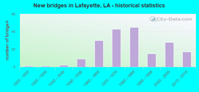
- New bridges - historical statistics
- 11920-1929
- 11930-1939
- 21940-1949
- 91950-1959
- 301960-1969
- 431970-1979
- 451980-1989
- 151990-1999
- 282000-2009
- 172010-2019
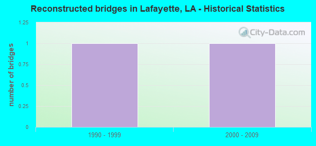
- Reconstructed bridges - Historical Statistics
- 11990-1999
- 12000-2009
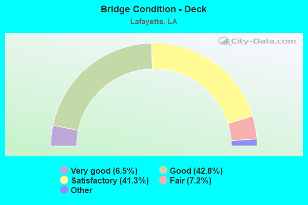
- Bridge Condition - Deck
- 6.5%Excellent
- 42.8%Very good
- 41.3%Good
- 7.2%Satisfactory
- 2.2%Fair
- 0.7%Poor
- 0.7%Failed
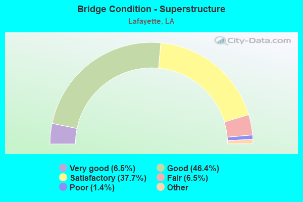
- Bridge Condition - Superstructure
- 6.5%Excellent
- 46.4%Very good
- 37.7%Good
- 6.5%Satisfactory
- 1.4%Fair
- 1.4%Poor
- 0.7%Failed
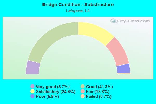
- Bridge Condition - Substructure
- 8.7%Very good
- 41.3%Good
- 24.6%Satisfactory
- 18.8%Fair
- 5.8%Poor
- 0.7%Failed
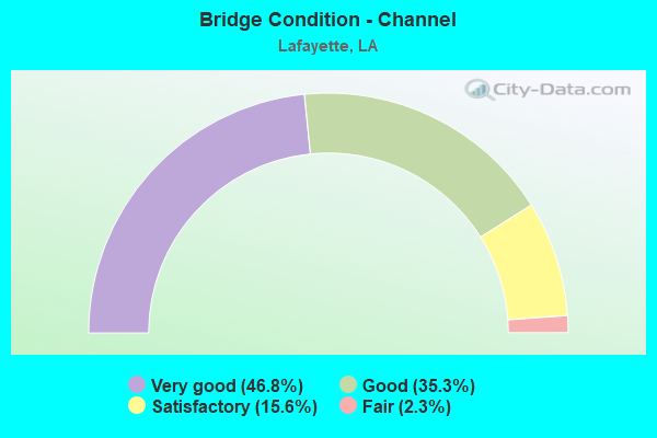
- Bridge Condition - Channel
- 46.8%Very good
- 35.3%Good
- 15.6%Satisfactory
- 2.3%Fair
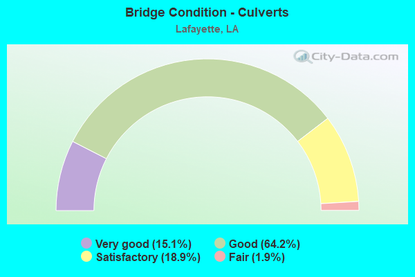
- Bridge Condition - Culverts
- 15.1%Very good
- 64.2%Good
- 18.9%Satisfactory
- 1.9%Fair
Find on map >> Show street view
Structure Number: 32804550102511, Location: 1.0 MI W OF LA 728 (Lat: 30.295561, Lng: -92.025069), Route carried "under" structure: State highway 98, Structure Length: 0. m, Average Daily Traffic: 11,600 (year 2016), Features Intersected: LA 98 EB UNDER I-49 NB
Minimum Vertical Clearance: 4.79m (15.72ft), Kilometerpoint: 11.476, Lanes on structure: 2, Length of Maximum Span: 0.0m
Find on map >> Show street view
Structure Number: 32804550102511, Location: 1.0 MI W OF LA 728 (Lat: 30.295739, Lng: -92.024981), Route carried "under" structure: State highway 98, Structure Length: 0. m, Average Daily Traffic: 11,600 (year 2016), Features Intersected: LA 98 WB UNDER I-49 NB
Minimum Vertical Clearance: 4.82m (15.81ft), Kilometerpoint: 7.145, Lanes on structure: 2, Length of Maximum Span: 0.0m
Find on map >> Show street view
Structure Number: 32804550102512, Location: 1.0 MI W OF LA 728 (Lat: 30.295569, Lng: -92.025381), Route carried "under" structure: State highway 98, Structure Length: 0. m, Average Daily Traffic: 11,600 (year 2016), Features Intersected: LA 98 EB UNDER I-49 SB
Minimum Vertical Clearance: 4.85m (15.91ft), Kilometerpoint: 11.447, Lanes on structure: 2, Length of Maximum Span: 0.0m
Find on map >> Show street view
Structure Number: 32804550102512, Location: 1.0 MI W OF LA 728 (Lat: 30.295750, Lng: -92.025289), Route carried "under" structure: State highway 98, Structure Length: 0. m, Average Daily Traffic: 11,600 (year 2016), Features Intersected: LA 98 WB UNDER I-49 SB
Minimum Vertical Clearance: 4.85m (15.91ft), Kilometerpoint: 7.174, Lanes on structure: 2, Length of Maximum Span: 0.0m
Find on map >> Show street view
Structure Number: 32808283200881, Location: 3.0 MI E OF LA 95 (Lat: 30.247300, Lng: -92.142200), Route carried "under" structure: Interstate 10, Structure Length: 0. m, Average Daily Traffic: 53,100 (year 2014), Features Intersected: I-10 EB UNDER LA 724
Minimum Vertical Clearance: 4.94m (16.21ft), Kilometerpoint: 3.269, Lanes on structure: 2, Length of Maximum Span: 0.0m
Find on map >> Show street view
Structure Number: 32808283200881, Location: 2.0 MI W OF LA 93 (Lat: 30.247539, Lng: -92.142111), Route carried "under" structure: Interstate 10, Structure Length: 0. m, Average Daily Traffic: 53,100 (year 2014), Features Intersected: I-10 WB UNDER LA 724
Minimum Vertical Clearance: 4.94m (16.21ft), Kilometerpoint: 19.214, Lanes on structure: 2, Length of Maximum Span: 0.0m
Find on map >> Show street view
Structure Number: 35000563001171, Location: 1.30 MI E OF LA 354 (Lat: 30.289589, Lng: -91.930611), Route carried "under" structure: Interstate 10, Structure Length: 0. m, Average Daily Traffic: 64,800 (year 2014), Features Intersected: I-10 EB UNDER LA 31
Minimum Vertical Clearance: 5.12m (16.80ft), Kilometerpoint: 2.095, Lanes on structure: 2, Length of Maximum Span: 0.0m
Find on map >> Show street view
Structure Number: 35000563001171, Location: 0.96 MI W OF LA 328 (Lat: 30.289839, Lng: -91.930669), Route carried "under" structure: Interstate 10, Structure Length: 0. m, Average Daily Traffic: 64,800 (year 2014), Features Intersected: I-10 WB UNDER LA 31
Minimum Vertical Clearance: 5.18m (16.99ft), Kilometerpoint: 28.695, Lanes on structure: 2, Length of Maximum Span: 0.0m
Find on map >> Show street view
Structure Number: 35004500600001, Location: 4.20 MI E OF I-49 (Lat: 30.280961, Lng: -91.949981), Route carried "under" structure: Interstate 10, Structure Length: 0. m, Average Daily Traffic: 64,800 (year 2014), Features Intersected: I-10 EB UNDER LA 354
Minimum Vertical Clearance: 5.12m (16.80ft), Kilometerpoint: 22.491, Lanes on structure: 2, Length of Maximum Span: 0.0m
Find on map >> Show street view
Structure Number: 35004500600001, Location: 1.30 MI W OF LA 31 (Lat: 30.281231, Lng: -91.949950), Route carried "under" structure: Interstate 10, Structure Length: 0. m, Average Daily Traffic: 64,800 (year 2014), Features Intersected: I-10 WB UNDER LA 354
Minimum Vertical Clearance: 5.12m (16.80ft), Kilometerpoint: 30.782, Lanes on structure: 2, Length of Maximum Span: 0.0m