Bridge Statistics for Las Vegas, Nevada (NV)
Condition, Traffic, Stress, Structural Evaluation, Project Costs
- National Bridge Inventory (NBI) Statistics
- 793Number of bridges
- 12,585ft / 3,836mTotal length
- $111,427,000Total costs
- 28,103,074Total average daily traffic
- 1,412,722Total average daily truck traffic
- National Bridge Inventory (NBI) Registered Bridges for Las Vegas
- No street view available for this location
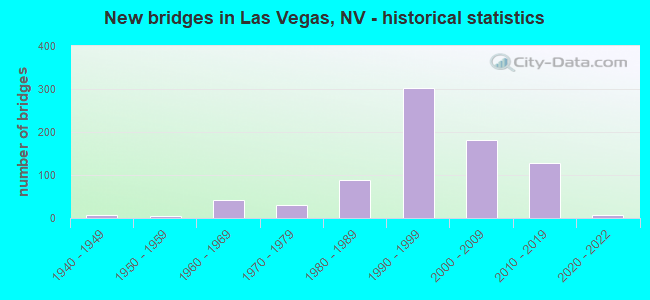
- New bridges - historical statistics
- 11930-1939
- 61940-1949
- 41950-1959
- 431960-1969
- 301970-1979
- 891980-1989
- 3021990-1999
- 1822000-2009
- 1292010-2019
- 72020-2022

- Reconstructed bridges - Historical Statistics
- 11940-1949
- 01950-1959
- 21960-1969
- 01970-1979
- 01980-1989
- 31990-1999
- 152000-2009
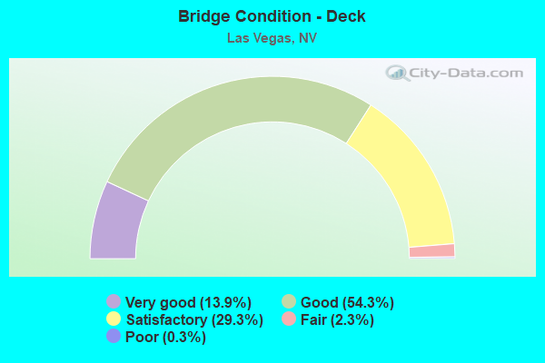
- Bridge Condition - Deck
- 13.9%Very good
- 54.3%Good
- 29.3%Satisfactory
- 2.3%Fair
- 0.3%Poor
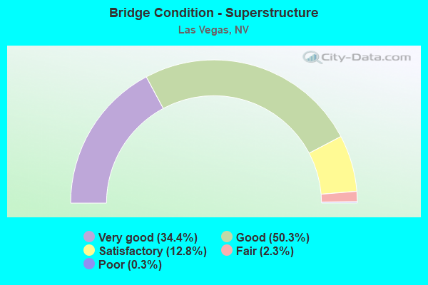
- Bridge Condition - Superstructure
- 34.4%Very good
- 50.3%Good
- 12.8%Satisfactory
- 2.3%Fair
- 0.3%Poor
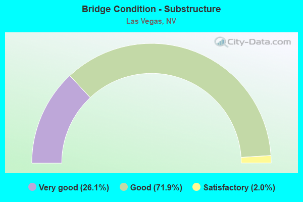
- Bridge Condition - Substructure
- 26.1%Very good
- 71.9%Good
- 2.0%Satisfactory
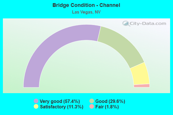
- Bridge Condition - Channel
- 57.4%Very good
- 29.6%Good
- 11.3%Satisfactory
- 1.8%Fair
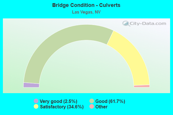
- Bridge Condition - Culverts
- 2.5%Very good
- 61.7%Good
- 34.6%Satisfactory
- 1.3%Fair
- 0.4%Poor
Find on map >> Show street view
Structure Number: I2004N, Location: SW LAS VEGAS (Lat: 36.099889, Lng: -115.293694), Route carried "on" structure: County highway CC215, Year Built: 2009, Status: Open, Structure Length: 7.41m (24.31ft), Average Daily Traffic: 33,000 (year 2017), Truck Traffic: 5%, Average Future Daily Traffic: 68,248 (year 2040), Design Load: HS 20+Mod, Features Intersected: TROPICANA AV., Facility Carried by Structure: CC 215
Minimum Vertical Clearance: 30+ m (98+ ft), Kilometerpoint: 0.000, Lanes on structure: 4, Lanes under structure: 9, Base Highway Network: Yes, Owner: County Highway Agency, Approaching Roadway Width: 22.3m (73.2ft), Skew: 2 degrees, Material/Design: Prestressed concrete continuous, Design/Construction: Box Beam or Girders - Single/Spread, Number Of Spans In Main Unit: 2, Length of Maximum Span: 32.7m (107.3ft), Curb-To-Curb Width: 25.6m (84.0ft), Out-to-Out Width: 26.4m (86.6ft)
Condition: Deck: Good, Superstructure: Very good, Substructure: Very good, Inventory Rating: 56.1 metric tons, Method Used To Determine Inventory Rating: Load Factor (LF), Structural Evaluation: Equal to present desirable criteria, Deck Geometry: Superior to present desirable criteria, Underclear: Superior to present desirable criteria, Approach Roadway Alignment: Equal to present desirable criteria, Designated Inspection Frequency: Every 24 months, Inspection Date: October 2021, Deck Structure Type: Concrete Cast-file-Place, Wearing Surface/Protective System: Wearing Surface: Monolithic Concrete
Find on map >> Show street view
Structure Number: I2004S, Location: SW LAS VEGAS (Lat: 36.100094, Lng: -115.294044), Route carried "on" structure: County highway 215, Year Built: 2007, Status: Open, Structure Length: 7.15m (23.46ft), Average Daily Traffic: 33,000 (year 2017), Truck Traffic: 5%, Average Future Daily Traffic: 68,248 (year 2040), Design Load: HS 20+Mod, Features Intersected: TROPICANA AVE
Minimum Vertical Clearance: 30+ m (98+ ft), Kilometerpoint: 0.000, Lanes on structure: 4, Lanes under structure: 9, Base Highway Network: Yes, Owner: County Highway Agency, Approaching Roadway Width: 22.6m (74.1ft), Skew: 2 degrees, Material/Design: Prestressed concrete continuous, Design/Construction: Box Beam or Girders - Single/Spread, Number Of Spans In Main Unit: 2, Length of Maximum Span: 37.2m (122.0ft), Curb-To-Curb Width: 25.6m (84.0ft), Out-to-Out Width: 26.4m (86.6ft)
Condition: Deck: Good, Superstructure: Very good, Substructure: Very good, Inventory Rating: 56.1 metric tons, Method Used To Determine Inventory Rating: Load Factor (LF), Structural Evaluation: Equal to present desirable criteria, Deck Geometry: Superior to present desirable criteria, Underclear: Equal to present minimum criteria, Approach Roadway Alignment: Equal to present desirable criteria, Designated Inspection Frequency: Every 24 months, Inspection Date: October 2021, Deck Structure Type: Concrete Cast-file-Place, Wearing Surface/Protective System: Wearing Surface: Monolithic Concrete
Find on map >> Show street view
Structure Number: I2005, Location: S.E OF LAS VEGAS (Lat: 36.063817, Lng: -115.176453), Route carried "on" structure: Ramp State highway , Year Built: 1998, Status: Open, Structure Length: 17.20m (56.43ft), Average Daily Traffic: 7,300 (year 2017), Truck Traffic: 3%, Average Future Daily Traffic: 15,097 (year 2040), Design Load: HS 20+Mod, Features Intersected: I 215W RAMP TO I 15N, Facility Carried by Structure: RAMP LVB TO I 215W
Minimum Vertical Clearance: 30+ m (98+ ft), Kilometerpoint: 0.000, Lanes on structure: 1, Lanes under structure: 2, Owner: County Highway Agency, Maintenance Responsibility: State Highway Agency, Approaching Roadway Width: 9.1m (29.9ft), Material/Design: Prestressed concrete continuous, Design/Construction: Box Beam or Girders - Single/Spread, Number Of Spans In Main Unit: 5, Length of Maximum Span: 36.6m (120.1ft), Curb-To-Curb Width: 9.1m (29.9ft), Out-to-Out Width: 10.0m (32.8ft)
Condition: Deck: Satisfactory, Superstructure: Good, Substructure: Good, Inventory Rating: 65.3 metric tons, Method Used To Determine Inventory Rating: Load Factor (LF), Structural Evaluation: Better than present minimum criteria, Deck Geometry: Superior to present desirable criteria, Underclear: High priority of corrective action, Approach Roadway Alignment: Equal to present desirable criteria, Designated Inspection Frequency: Every 24 months, Inspection Date: December 2020, Deck Structure Type: Concrete Cast-file-Place, Wearing Surface/Protective System: Wearing Surface: Monolithic Concrete
Find on map >> Show street view
Structure Number: I2006, Location: LAS VEGAS (Lat: 36.061711, Lng: -115.178108), Route carried "on" structure: Ramp Interstate 215, Year Built: 1994, Status: Open, Structure Length: 9.78m (32.09ft), Average Daily Traffic: 7,100 (year 2017), Truck Traffic: 8%, Average Future Daily Traffic: 14,684 (year 2040), Design Load: HS 20+Mod, Features Intersected: RMP I 15N TO I 215E
Minimum Vertical Clearance: 30+ m (98+ ft), Kilometerpoint: 0.000, Lanes on structure: 2, Lanes under structure: 1, Base Highway Network: Yes, Owner: County Highway Agency, Maintenance Responsibility: State Highway Agency, Approaching Roadway Width: 12.2m (40.0ft), Material/Design: Prestressed concrete continuous, Design/Construction: Box Beam or Girders - Multiple, Number Of Spans In Main Unit: 3, Length of Maximum Span: 36.9m (121.1ft), Curb-To-Curb Width: 12.2m (40.0ft), Out-to-Out Width: 13.1m (43.0ft)
Condition: Deck: Good, Superstructure: Good, Substructure: Good, Inventory Rating: 65.3 metric tons, Method Used To Determine Inventory Rating: Load Factor (LF), Structural Evaluation: Better than present minimum criteria, Deck Geometry: Superior to present desirable criteria, Underclear: Equal to present minimum criteria, Approach Roadway Alignment: Equal to present desirable criteria, Length Of Structure Improvement: 10.72m (35.17ft), Designated Inspection Frequency: Every 24 months, Inspection Date: Febuary 2021, Bridge Improvement Cost: $1,151,000, Roadway Improvement Cost: $115,000, Total Project Cost: $1,727,000, Deck Structure Type: Concrete Cast-file-Place, Wearing Surface/Protective System: Wearing Surface: Monolithic Concrete
Find on map >> Show street view
Structure Number: I2063, Location: LAS VEGAS (Lat: 36.178608, Lng: -115.259875), Route carried "on" structure: City street , Year Built: 1994, Status: Open, Structure Length: 6.07m (19.91ft), Average Daily Traffic: 38,000 (year 2017), Average Future Daily Traffic: 78,588 (year 2040), Design Load: HS 20, Features Intersected: SUMMERLIN PKW, Facility Carried by Structure: BUFFALO DRIVE
Minimum Vertical Clearance: 30+ m (98+ ft), Kilometerpoint: 0.000, Lanes on structure: 8, Lanes under structure: 6, Owner: City or Municipal Highway Agency, Approaching Roadway Width: 29.0m (95.1ft), Skew: 20 degrees, Material/Design: Prestressed concrete, Design/Construction: Stringer/Multi-beam, Number Of Spans In Main Unit: 2, Length of Maximum Span: 30.2m (99.1ft), Curb or Sidewalk Widths: Left: 1.8m (5.9ft), Right: 0.0m, Curb-To-Curb Width: 29.0m (95.1ft), Out-to-Out Width: 31.9m (104.7ft)
Condition: Deck: Good, Superstructure: Good, Substructure: Good, Operating Rating: 87.4 metric tons, Method Used To Determine Operating Rating: Load Factor (LF), Inventory Rating: 49.3 metric tons, Method Used To Determine Inventory Rating: Load Factor (LF), Structural Evaluation: Better than present minimum criteria, Deck Geometry: Meets minimum limits, Underclear: Equal to present minimum criteria, Approach Roadway Alignment: Equal to present desirable criteria, Designated Inspection Frequency: Every 48 months, Inspection Date: January 2020, Deck Structure Type: Concrete Cast-file-Place, Wearing Surface/Protective System: Wearing Surface: Monolithic Concrete
Find on map >> Show street view
Structure Number: I2135, Location: LAS VEGAS (Lat: 36.085039, Lng: -115.144728), Route carried "on" structure: City street , Year Built: 1994, Status: Open, Structure Length: 6.00m (19.69ft), Average Daily Traffic: 38,500 (year 2017), Truck Traffic: 8%, Average Future Daily Traffic: 79,623 (year 2040), Design Load: HS 20+Mod, Features Intersected: RUSSELL RD, Facility Carried by Structure: PARADISE RD
Minimum Vertical Clearance: 30+ m (98+ ft), Kilometerpoint: 0.000, Lanes on structure: 4, Lanes under structure: 3, Owner: Local Agency, Approaching Roadway Width: 22.6m (74.1ft), Skew: 20 degrees, Material/Design: Prestressed concrete continuous, Design/Construction: Box Beam or Girders - Multiple, Number Of Spans In Main Unit: 1, Length of Maximum Span: 59.1m (193.9ft), Curb-To-Curb Width: 22.6m (74.1ft), Out-to-Out Width: 24.7m (81.0ft)
Condition: Deck: Satisfactory, Superstructure: Good, Substructure: Good, Inventory Rating: 73.5 metric tons, Method Used To Determine Inventory Rating: Load Factor (LF), Structural Evaluation: Better than present minimum criteria, Deck Geometry: Superior to present desirable criteria, Underclear: Somewhat better than minimum adequacy, Approach Roadway Alignment: Equal to present desirable criteria, Designated Inspection Frequency: Every 24 months, Inspection Date: November 2020, Deck Structure Type: Concrete Cast-file-Place, Wearing Surface/Protective System: Wearing Surface: Monolithic Concrete
Find on map >> Show street view
Structure Number: I2138, Location: LAS VEGAS (Lat: 36.172389, Lng: -115.156883), Route carried "on" structure: Interstate 15, Year Built: 1998, Status: Open, Structure Length: 3.35m (10.99ft), Average Daily Traffic: 248,000 (year 2017), Truck Traffic: 20%, Average Future Daily Traffic: 512,893 (year 2040), Design Load: HS 20+Mod, Features Intersected: US 95 OFF RAMP TO I 15N
Minimum Vertical Clearance: 30+ m (98+ ft), Kilometerpoint: 68.770, Lanes on structure: 8, Lanes under structure: 1, Base Highway Network: Yes, Owner: State Highway Agency, Approaching Roadway Width: 48.1m (157.8ft), Skew: 30 degrees, Material/Design: Prestressed concrete, Design/Construction: Box Beam or Girders - Single/Spread, Number Of Spans In Main Unit: 1, Length of Maximum Span: 33.5m (109.9ft), Curb-To-Curb Width: 48.1m (157.8ft), Out-to-Out Width: 49.7m (163.1ft)
Condition: Deck: Good, Superstructure: Good, Substructure: Good, Operating Rating: 90.5 metric tons, Method Used To Determine Operating Rating: Load Factor (LF), Inventory Rating: 62.7 metric tons, Method Used To Determine Inventory Rating: Load Factor (LF), Structural Evaluation: Better than present minimum criteria, Deck Geometry: Superior to present desirable criteria, Underclear: High priority of corrective action, Approach Roadway Alignment: Equal to present desirable criteria, Designated Inspection Frequency: Every 48 months, Inspection Date: March 2019, Deck Structure Type: Concrete Cast-file-Place, Wearing Surface/Protective System: Wearing Surface: Bituminous
Find on map >> Show street view
Structure Number: I2139, Location: NEON SPAGHETTI BOWL (Lat: 36.174931, Lng: -115.160797), Route carried "on" structure: Ramp City street , Year Built: 2018, Status: Open, Structure Length: 47.04m (154.33ft), Average Daily Traffic: 6,900 (year 2017), Truck Traffic: 5%, Average Future Daily Traffic: 7,000 (year 2037), Design Load: HL 93, Features Intersected: MLK BLVD, Facility Carried by Structure: ES1 RAMP US95S
Minimum Vertical Clearance: 4.91m (16.11ft), Kilometerpoint: 0.000, Lanes on structure: 2, Lanes under structure: 11, Base Highway Network: Yes, Owner: State Highway Agency, Approaching Roadway Width: 11.0m (36.1ft), Material/Design: Prestressed concrete continuous, Design/Construction: Box Beam or Girders - Single/Spread, Number Of Spans In Main Unit: 11, Length of Maximum Span: 47.4m (155.5ft), Curb-To-Curb Width: 11.0m (36.1ft), Out-to-Out Width: 11.9m (39.0ft)
Condition: Deck: Good, Superstructure: Good, Substructure: Very good, Operating Rating: 59.0 metric tons, Method Used To Determine Operating Rating: Load and Resistance Factor (LRFR), Inventory Rating: 46.3 metric tons, Method Used To Determine Inventory Rating: Load and Resistance Factor (LRFR), Structural Evaluation: Better than present minimum criteria, Deck Geometry: Better than present minimum criteria, Underclear: Somewhat better than minimum adequacy, Approach Roadway Alignment: Equal to present desirable criteria, Designated Inspection Frequency: Every 24 months, Inspection Date: Febuary 2021, Deck Structure Type: Concrete Cast-file-Place, Wearing Surface/Protective System: Wearing Surface: Monolithic Concrete
Find on map >> Show street view
Structure Number: I214, Location: LAS VEGAS (Lat: 36.174592, Lng: -115.158531), Route carried "on" structure: Ramp Interstate 95, Year Built: 1999, Status: Open, Structure Length: 10.90m (35.76ft), Average Daily Traffic: 12,200 (year 2017), Average Future Daily Traffic: 25,231 (year 2040), Design Load: HS 20+Mod, Features Intersected: MLK TO US 95E
Minimum Vertical Clearance: 30+ m (98+ ft), Kilometerpoint: 0.000, Lanes on structure: 1, Lanes under structure: 1, Base Highway Network: Yes, Owner: State Highway Agency, Approaching Roadway Width: 7.2m (23.6ft), Material/Design: Prestressed concrete continuous, Design/Construction: Box Beam or Girders - Single/Spread, Number Of Spans In Main Unit: 4, Length of Maximum Span: 32.0m (105.0ft), Curb-To-Curb Width: 7.2m (23.6ft), Out-to-Out Width: 8.1m (26.6ft)
Condition: Deck: Good, Superstructure: Good, Substructure: Very good, Operating Rating: 84.9 metric tons, Method Used To Determine Operating Rating: Load Factor (LF), Inventory Rating: 50.9 metric tons, Method Used To Determine Inventory Rating: Load Factor (LF), Structural Evaluation: Better than present minimum criteria, Deck Geometry: Equal to present minimum criteria, Underclear: Meets minimum limits, Approach Roadway Alignment: Equal to present desirable criteria, Designated Inspection Frequency: Every 24 months, Inspection Date: Febuary 2021, Deck Structure Type: Concrete Cast-file-Place, Wearing Surface/Protective System: Wearing Surface: Monolithic Concrete
Find on map >> Show street view
Structure Number: I2141, Location: LAS VEGAS (Lat: 36.174194, Lng: -115.156739), Route carried "on" structure: Ramp Interstate 15, Year Built: 1999, Status: Open, Structure Length: 55.60m (182.41ft), Average Daily Traffic: 15,200 (year 2017), Truck Traffic: 2%, Average Future Daily Traffic: 31,435 (year 2040), Design Load: HS 20+Mod, Features Intersected: I 15N/S
Minimum Vertical Clearance: 30+ m (98+ ft), Kilometerpoint: 69.001, Lanes on structure: 1, Lanes under structure: 18, Base Highway Network: Yes, Owner: State Highway Agency, Approaching Roadway Width: 7.2m (23.6ft), Material/Design: Prestressed concrete continuous, Design/Construction: Segmental Box Girder, Number Of Spans In Main Unit: 13, Number Of Approach Spans: 2, Length of Maximum Span: 45.0m (147.6ft), Curb-To-Curb Width: 7.2m (23.6ft), Out-to-Out Width: 8.1m (26.6ft)
Condition: Deck: Very good, Superstructure: Good, Substructure: Good, Operating Rating: 58.4 metric tons, Method Used To Determine Operating Rating: Load Factor (LF), Inventory Rating: 34.9 metric tons, Method Used To Determine Inventory Rating: Load Factor (LF), Structural Evaluation: Better than present minimum criteria, Deck Geometry: Equal to present minimum criteria, Underclear: High priority of corrective action, Approach Roadway Alignment: Equal to present desirable criteria, Designated Inspection Frequency: Every 24 months, Inspection Date: Febuary 2021, Deck Structure Type: Concrete Cast-file-Place, Wearing Surface/Protective System: Wearing Surface: Epoxy Overlay
Find on map >> Show street view
Structure Number: I2141R, Location: LAS VEGAS (Lat: 36.175136, Lng: -115.155372), Route carried "on" structure: Ramp Interstate 15, Year Built: 2000, Status: Open, Structure Length: 11.68m (38.32ft), Average Daily Traffic: 13,800 (year 2017), Average Future Daily Traffic: 28,540 (year 2040), Design Load: HS 20+Mod, Features Intersected: RMP N-MLK & W-MLK
Minimum Vertical Clearance: 30+ m (98+ ft), Kilometerpoint: 0.000, Lanes on structure: 1, Lanes under structure: 2, Owner: State Highway Agency, Approaching Roadway Width: 7.2m (23.6ft), Material/Design: Prestressed concrete continuous, Design/Construction: Box Beam or Girders - Single/Spread, Number Of Spans In Main Unit: 3, Length of Maximum Span: 44.0m (144.4ft), Curb-To-Curb Width: 7.2m (23.6ft), Out-to-Out Width: 8.1m (26.6ft)
Condition: Deck: Very good, Superstructure: Very good, Substructure: Very good, Operating Rating: 76.0 metric tons, Method Used To Determine Operating Rating: Load Factor (LF), Inventory Rating: 45.7 metric tons, Method Used To Determine Inventory Rating: Load Factor (LF), Structural Evaluation: Equal to present desirable criteria, Deck Geometry: Equal to present minimum criteria, Underclear: Meets minimum limits, Approach Roadway Alignment: Equal to present desirable criteria, Designated Inspection Frequency: Every 24 months, Inspection Date: Febuary 2021, Deck Structure Type: Concrete Cast-file-Place, Wearing Surface/Protective System: Wearing Surface: Epoxy Overlay
Find on map >> Show street view
Structure Number: I2143E, Location: LAS VEGAS (Lat: 36.177686, Lng: -115.287186), Route carried "on" structure: City street , Year Built: 1995, Status: Open, Structure Length: 4.85m (15.91ft), Average Daily Traffic: 41,500 (year 2017), Truck Traffic: 3%, Average Future Daily Traffic: 85,827 (year 2040), Design Load: HS 20+Mod, Features Intersected: RAMPART BL, Facility Carried by Structure: SUMMERLIN PARKWAY
Minimum Vertical Clearance: 30+ m (98+ ft), Kilometerpoint: 0.000, Lanes on structure: 2, Lanes under structure: 9, Base Highway Network: Yes, Owner: City or Municipal Highway Agency, Approaching Roadway Width: 15.8m (51.8ft), Material/Design: Prestressed concrete, Design/Construction: Box Beam or Girders - Single/Spread, Number Of Spans In Main Unit: 1, Length of Maximum Span: 47.9m (157.2ft), Curb-To-Curb Width: 15.8m (51.8ft), Out-to-Out Width: 16.8m (55.1ft)
Condition: Deck: Good, Superstructure: Very good, Substructure: Good, Inventory Rating: 81.6 metric tons, Method Used To Determine Inventory Rating: Load Factor (LF), Structural Evaluation: Better than present minimum criteria, Deck Geometry: Superior to present desirable criteria, Underclear: Meets minimum limits, Approach Roadway Alignment: Equal to present desirable criteria, Designated Inspection Frequency: Every 24 months, Inspection Date: November 2021, Deck Structure Type: Concrete Cast-file-Place, Wearing Surface/Protective System: Wearing Surface: Monolithic Concrete
Find on map >> Show street view
Structure Number: I2143W, Location: LAS VEGAS (Lat: 36.178028, Lng: -115.287164), Route carried "on" structure: City street , Year Built: 1995, Status: Open, Structure Length: 4.85m (15.91ft), Average Daily Traffic: 41,500 (year 2017), Truck Traffic: 3%, Average Future Daily Traffic: 85,827 (year 2040), Design Load: HS 20+Mod, Features Intersected: RAMPART BLVD, Facility Carried by Structure: SUMMERLIN PARKWAY
Minimum Vertical Clearance: 30+ m (98+ ft), Kilometerpoint: 0.000, Lanes on structure: 3, Lanes under structure: 9, Base Highway Network: Yes, Owner: City or Municipal Highway Agency, Approaching Roadway Width: 19.5m (64.0ft), Material/Design: Prestressed concrete, Design/Construction: Box Beam or Girders - Single/Spread, Number Of Spans In Main Unit: 1, Length of Maximum Span: 47.9m (157.2ft), Curb-To-Curb Width: 19.5m (64.0ft), Out-to-Out Width: 20.4m (66.9ft)
Condition: Deck: Good, Superstructure: Very good, Substructure: Good, Inventory Rating: 85.5 metric tons, Method Used To Determine Inventory Rating: Load Factor (LF), Structural Evaluation: Better than present minimum criteria, Deck Geometry: Superior to present desirable criteria, Underclear: Meets minimum limits, Approach Roadway Alignment: Equal to present desirable criteria, Designated Inspection Frequency: Every 24 months, Inspection Date: November 2021, Deck Structure Type: Concrete Cast-file-Place, Wearing Surface/Protective System: Wearing Surface: Monolithic Concrete
Find on map >> Show street view
Structure Number: I2312, Location: WEST OF LAS VEGAS (Lat: 36.115056, Lng: -115.302544), Route carried "on" structure: County highway , Year Built: 2001, Status: Open, Structure Length: 10.12m (33.20ft), Average Daily Traffic: 41,000 (year 2017), Truck Traffic: 1%, Average Future Daily Traffic: 84,793 (year 2040), Features Intersected: I 215 WESTERN BELTWAY, Facility Carried by Structure: FLAMINGO ROAD
Minimum Vertical Clearance: 30+ m (98+ ft), Kilometerpoint: 0.000, Lanes on structure: 10, Lanes under structure: 6, Owner: County Highway Agency, Approaching Roadway Width: 41.7m (136.8ft), Skew: 25 degrees, Material/Design: Prestressed concrete continuous, Design/Construction: Box Beam or Girders - Multiple, Number Of Spans In Main Unit: 2, Length of Maximum Span: 50.4m (165.4ft), Curb or Sidewalk Widths: Left: 1.5m (4.9ft), Right: 1.5m (4.9ft), Curb-To-Curb Width: 41.7m (136.8ft), Out-to-Out Width: 42.0m (137.8ft)
Condition: Deck: Good, Superstructure: Good, Substructure: Good, Operating Rating: 32.7 metric tons, Method Used To Determine Operating Rating: Field evaluation and documented engineering judgment, Inventory Rating: 19.6 metric tons, Method Used To Determine Inventory Rating: Field evaluation and documented engineering judgment, Structural Evaluation: Meets minimum limits, Deck Geometry: Better than present minimum criteria, Underclear: Better than present minimum criteria, Approach Roadway Alignment: Equal to present desirable criteria, Designated Inspection Frequency: Every 24 months, Inspection Date: December 2020, Deck Structure Type: Concrete Cast-file-Place, Wearing Surface/Protective System: Wearing Surface: Monolithic Concrete
Find on map >> Show street view
Structure Number: I2316, Location: LAS VEGAS (Lat: 36.121606, Lng: -115.326514), Route carried "on" structure: County highway , Year Built: 2006, Status: Open, Structure Length: 5.57m (18.27ft), Average Daily Traffic: 14,000 (year 2017), Truck Traffic: 2%, Average Future Daily Traffic: 28,954 (year 2040), Design Load: HS 20+Mod, Features Intersected: CC 215, Facility Carried by Structure: TOWN CENTER DR
Minimum Vertical Clearance: 30+ m (98+ ft), Kilometerpoint: 0.000, Lanes on structure: 8, Lanes under structure: 5, Owner: County Highway Agency, Approaching Roadway Width: 31.0m (101.7ft), Material/Design: Prestressed concrete continuous, Design/Construction: Box Beam or Girders - Single/Spread, Number Of Spans In Main Unit: 2, Length of Maximum Span: 27.4m (89.9ft), Curb or Sidewalk Widths: Left: 2.1m (6.9ft), Right: 1.9m (6.2ft), Curb-To-Curb Width: 34.7m (113.8ft), Out-to-Out Width: 48.7m (159.8ft)
Condition: Deck: Good, Superstructure: Good, Substructure: Good, Operating Rating: 80.6 metric tons, Method Used To Determine Operating Rating: Load Factor (LF), Inventory Rating: 48.3 metric tons, Method Used To Determine Inventory Rating: Load Factor (LF), Structural Evaluation: Better than present minimum criteria, Deck Geometry: Better than present minimum criteria, Underclear: Somewhat better than minimum adequacy, Approach Roadway Alignment: Equal to present desirable criteria, Designated Inspection Frequency: Every 48 months, Inspection Date: January 2020, Deck Structure Type: Concrete Cast-file-Place, Wearing Surface/Protective System: Wearing Surface: Monolithic Concrete
Find on map >> Show street view
Structure Number: I2318, Location: SOUTH SUMMERLIN (Lat: 36.144497, Lng: -115.336664), Route carried "on" structure: County highway 589, Year Built: 2000, Status: Open, Structure Length: 7.35m (24.11ft), Average Daily Traffic: 14,600 (year 2017), Truck Traffic: 3%, Average Future Daily Traffic: 30,195 (year 2040), Design Load: HS 20+Mod, Features Intersected: CC 215
Minimum Vertical Clearance: 30+ m (98+ ft), Kilometerpoint: 0.000, Lanes on structure: 10, Lanes under structure: 6, Owner: County Highway Agency, Approaching Roadway Width: 39.3m (128.9ft), Skew: 20 degrees, Material/Design: Prestressed concrete continuous, Design/Construction: Box Beam or Girders - Multiple, Number Of Spans In Main Unit: 2, Length of Maximum Span: 36.9m (121.1ft), Curb or Sidewalk Widths: Left: 1.8m (5.9ft), Right: 1.8m (5.9ft), Curb-To-Curb Width: 39.3m (128.9ft), Out-to-Out Width: 44.5m (146.0ft)
Condition: Deck: Good, Superstructure: Good, Substructure: Good, Operating Rating: 74.1 metric tons, Method Used To Determine Operating Rating: Load Factor (LF), Inventory Rating: 44.4 metric tons, Method Used To Determine Inventory Rating: Load Factor (LF), Structural Evaluation: Better than present minimum criteria, Deck Geometry: Somewhat better than minimum adequacy, Underclear: Better than present minimum criteria, Approach Roadway Alignment: Equal to present desirable criteria, Length Of Structure Improvement: 8.28m (27.17ft), Designated Inspection Frequency: Every 24 months, Inspection Date: December 2020, Bridge Improvement Cost: $2,973,000, Roadway Improvement Cost: $297,000, Total Project Cost: $4,460,000, Deck Structure Type: Concrete Cast-file-Place, Wearing Surface/Protective System: Wearing Surface: Monolithic Concrete
Find on map >> Show street view
Structure Number: I2319, Location: SOUTH SUMMERLIN (Lat: 36.158992, Lng: -115.337272), Route carried "on" structure: State highway , Year Built: 2000, Status: Open, Structure Length: 7.96m (26.12ft), Average Daily Traffic: 18,500 (year 2017), Truck Traffic: 3%, Average Future Daily Traffic: 38,260 (year 2040), Design Load: HS 20+Mod, Features Intersected: CC 215 WESTERN BELTWAY, Facility Carried by Structure: CHARLESTON BL
Minimum Vertical Clearance: 30+ m (98+ ft), Kilometerpoint: 0.000, Lanes on structure: 10, Lanes under structure: 8, Owner: County Highway Agency, Approaching Roadway Width: 40.6m (133.2ft), Skew: 20 degrees, Material/Design: Prestressed concrete continuous, Design/Construction: Box Beam or Girders - Multiple, Number Of Spans In Main Unit: 2, Length of Maximum Span: 39.9m (130.9ft), Curb or Sidewalk Widths: Left: 1.7m (5.6ft), Right: 1.7m (5.6ft), Curb-To-Curb Width: 40.6m (133.2ft), Out-to-Out Width: 41.7m (136.8ft)
Condition: Deck: Good, Superstructure: Good, Substructure: Very good, Inventory Rating: 64.3 metric tons, Method Used To Determine Inventory Rating: Load Factor (LF), Structural Evaluation: Better than present minimum criteria, Deck Geometry: Somewhat better than minimum adequacy, Underclear: High priority of corrective action, Approach Roadway Alignment: Equal to present desirable criteria, Designated Inspection Frequency: Every 24 months, Inspection Date: December 2020, Deck Structure Type: Concrete Cast-file-Place, Wearing Surface/Protective System: Wearing Surface: Monolithic Concrete
Find on map >> Show street view
Structure Number: I2322, Location: WEST LAS VEGAS (Lat: 36.181472, Lng: -115.341333), Route carried "on" structure: City street , Year Built: 2009, Status: Open, Structure Length: 5.45m (17.88ft), Average Daily Traffic: 9,000 (year 2017), Truck Traffic: 1%, Average Future Daily Traffic: 15,000 (year 2040), Design Load: HS 25 or greater, Features Intersected: CC 215, Facility Carried by Structure: FAR HILLS AVENUE
Minimum Vertical Clearance: 30+ m (98+ ft), Kilometerpoint: 0.000, Lanes on structure: 4, Lanes under structure: 8, Owner: County Highway Agency, Approaching Roadway Width: 26.0m (85.3ft), Material/Design: Prestressed concrete, Design/Construction: Box Beam or Girders - Single/Spread, Number Of Spans In Main Unit: 1, Length of Maximum Span: 51.2m (168.0ft), Curb or Sidewalk Widths: Left: 2.1m (6.9ft), Right: 2.1m (6.9ft), Curb-To-Curb Width: 34.0m (111.5ft), Out-to-Out Width: 60.0m (196.9ft)
Condition: Deck: Good, Superstructure: Satisfactory, Substructure: Good, Operating Rating: 85.2 metric tons, Method Used To Determine Operating Rating: Load Factor (LF), Inventory Rating: 58.8 metric tons, Method Used To Determine Inventory Rating: Load Factor (LF), Structural Evaluation: Equal to present minimum criteria, Deck Geometry: Superior to present desirable criteria, Underclear: Equal to present minimum criteria, Approach Roadway Alignment: Equal to present desirable criteria, Designated Inspection Frequency: Every 24 months, Inspection Date: October 2021, Deck Structure Type: Concrete Cast-file-Place, Wearing Surface/Protective System: Wearing Surface: Monolithic Concrete
Find on map >> Show street view
Structure Number: I2323, Location: WEST LAS VEGAS (Lat: 36.191714, Lng: -115.342556), Route carried "on" structure: City street , Year Built: 2010, Status: Open, Structure Length: 7.10m (23.29ft), Average Daily Traffic: 46,000 (year 2017), Truck Traffic: 1%, Average Future Daily Traffic: 47,500 (year 2040), Design Load: HS 25 or greater, Features Intersected: CC 215, Facility Carried by Structure: SUMMERLIN PKWY
Minimum Vertical Clearance: 30+ m (98+ ft), Kilometerpoint: 0.000, Lanes on structure: 8, Lanes under structure: 8, Owner: County Highway Agency, Approaching Roadway Width: 37.9m (124.3ft), Skew: 20 degrees, Material/Design: Prestressed concrete continuous, Design/Construction: Box Beam or Girders - Single/Spread, Number Of Spans In Main Unit: 2, Length of Maximum Span: 35.8m (117.5ft), Curb-To-Curb Width: 37.9m (124.3ft), Out-to-Out Width: 38.8m (127.3ft)
Condition: Deck: Very good, Superstructure: Good, Substructure: Good, Inventory Rating: 65.3 metric tons, Method Used To Determine Inventory Rating: Load Factor (LF), Structural Evaluation: Better than present minimum criteria, Deck Geometry: Superior to present desirable criteria, Underclear: Equal to present minimum criteria, Approach Roadway Alignment: Equal to present desirable criteria, Designated Inspection Frequency: Every 24 months, Inspection Date: October 2021, Deck Structure Type: Concrete Cast-file-Place, Wearing Surface/Protective System: Wearing Surface: Monolithic Concrete
Find on map >> Show street view
Structure Number: I2324, Location: WEST LAS VEGAS (Lat: 36.205497, Lng: -115.340675), Route carried "on" structure: County highway , Year Built: 2009, Status: Open, Structure Length: 5.31m (17.42ft), Average Daily Traffic: 1,000 (year 2017), Truck Traffic: 1%, Average Future Daily Traffic: 12,000 (year 2040), Design Load: HS 20+Mod, Features Intersected: CC 215 WEST, Facility Carried by Structure: LAKE MEAD BLVD
Minimum Vertical Clearance: 30+ m (98+ ft), Kilometerpoint: 0.000, Lanes on structure: 4, Lanes under structure: 6, Owner: County Highway Agency, Approaching Roadway Width: 22.2m (72.8ft), Material/Design: Concrete continuous, Design/Construction: Box Beam or Girders - Single/Spread, Number Of Spans In Main Unit: 2, Length of Maximum Span: 26.5m (86.9ft), Curb or Sidewalk Widths: Left: 1.5m (4.9ft), Right: 1.5m (4.9ft), Curb-To-Curb Width: 35.3m (115.8ft), Out-to-Out Width: 39.7m (130.2ft)
Condition: Deck: Good, Superstructure: Very good, Substructure: Good, Operating Rating: 73.1 metric tons, Method Used To Determine Operating Rating: Load Factor (LF), Inventory Rating: 43.7 metric tons, Method Used To Determine Inventory Rating: Load Factor (LF), Structural Evaluation: Better than present minimum criteria, Deck Geometry: Superior to present desirable criteria, Underclear: Somewhat better than minimum adequacy, Approach Roadway Alignment: Somewhat better than minimum adequacy, Designated Inspection Frequency: Every 48 months, Inspection Date: Febuary 2021, Deck Structure Type: Concrete Cast-file-Place, Wearing Surface/Protective System: Wearing Surface: Monolithic Concrete
Find on map >> Show street view
Structure Number: I2325, Location: SW OF LAS VEGAS (Lat: 36.219258, Lng: -115.327728), Route carried "on" structure: County highway , Year Built: 2007, Status: Open, Structure Length: 8.46m (27.76ft), Average Daily Traffic: 19,500 (year 2017), Truck Traffic: 3%, Average Future Daily Traffic: 40,328 (year 2040), Design Load: HS 20+Mod, Features Intersected: CC 215 WEST, Facility Carried by Structure: CHEYENNE AVENUE
Minimum Vertical Clearance: 30+ m (98+ ft), Kilometerpoint: 0.000, Lanes on structure: 10, Lanes under structure: 6, Owner: County Highway Agency, Approaching Roadway Width: 12.5m (41.0ft), Skew: 20 degrees, Material/Design: Prestressed concrete continuous, Design/Construction: Box Beam or Girders - Single/Spread, Number Of Spans In Main Unit: 2, Length of Maximum Span: 43.8m (143.7ft), Curb or Sidewalk Widths: Left: 1.5m (4.9ft), Right: 1.5m (4.9ft), Curb-To-Curb Width: 38.3m (125.7ft), Out-to-Out Width: 43.8m (143.7ft)
Condition: Deck: Good, Superstructure: Good, Substructure: Good, Operating Rating: 87.2 metric tons, Method Used To Determine Operating Rating: Load Factor (LF), Inventory Rating: 52.2 metric tons, Method Used To Determine Inventory Rating: Load Factor (LF), Structural Evaluation: Better than present minimum criteria, Deck Geometry: Somewhat better than minimum adequacy, Underclear: Somewhat better than minimum adequacy, Approach Roadway Alignment: Equal to present desirable criteria, Designated Inspection Frequency: Every 24 months, Inspection Date: January 2020, Deck Structure Type: Concrete Cast-file-Place, Wearing Surface/Protective System: Wearing Surface: Monolithic Concrete
Find on map >> Show street view
Structure Number: I2339, Location: NORTH LAS VEGAS (Lat: 36.277894, Lng: -115.267189), Route carried "on" structure: County highway 215, Year Built: 2000, Status: Open, Structure Length: 15.14m (49.67ft), Average Daily Traffic: 9,200 (year 2017), Average Future Daily Traffic: 107,500 (year 2040), Design Load: HS 20+Mod, Features Intersected: US 95, Facility Carried by Structure: CENTENNIAL PW
Minimum Vertical Clearance: 30+ m (98+ ft), Kilometerpoint: 0.000, Lanes on structure: 5, Lanes under structure: 12, Owner: County Highway Agency, Approaching Roadway Width: 19.4m (63.6ft), Skew: 4 degrees, Material/Design: Prestressed concrete continuous, Design/Construction: Box Beam or Girders - Multiple, Number Of Spans In Main Unit: 4, Length of Maximum Span: 40.2m (131.9ft), Curb-To-Curb Width: 19.4m (63.6ft), Out-to-Out Width: 20.4m (66.9ft)
Condition: Deck: Satisfactory, Superstructure: Good, Substructure: Good, Operating Rating: 67.8 metric tons, Method Used To Determine Operating Rating: Load Factor (LF), Inventory Rating: 40.5 metric tons, Method Used To Determine Inventory Rating: Load Factor (LF), Structural Evaluation: Better than present minimum criteria, Deck Geometry: Meets minimum limits, Underclear: Equal to present minimum criteria, Approach Roadway Alignment: Equal to present desirable criteria, Designated Inspection Frequency: Every 24 months, Inspection Date: November 2021, Deck Structure Type: Concrete Cast-file-Place, Wearing Surface/Protective System: Wearing Surface: Monolithic Concrete
Find on map >> Show street view
Structure Number: I2356, Location: LAS VEGAS (Lat: 36.101372, Lng: -115.180083), Route carried "on" structure: Ramp State highway , Year Built: 2002, Status: Open, Structure Length: 3.70m (12.14ft), Average Daily Traffic: 31,000 (year 2017), Truck Traffic: 2%, Average Future Daily Traffic: 64,112 (year 2040), Design Load: HS 20+Mod, Features Intersected: I 15N OFF RAMP TO FRANK, Facility Carried by Structure: RMP TROP WB TO 15N
Minimum Vertical Clearance: 30+ m (98+ ft), Kilometerpoint: 0.000, Lanes on structure: 2, Lanes under structure: 2, Owner: State Highway Agency, Approaching Roadway Width: 12.1m (39.7ft), Skew: 3 degrees, Material/Design: Prestressed concrete, Design/Construction: Box Beam or Girders - Multiple, Number Of Spans In Main Unit: 1, Length of Maximum Span: 36.5m (119.8ft), Curb-To-Curb Width: 12.1m (39.7ft), Out-to-Out Width: 13.1m (43.0ft)
Condition: Deck: Good, Superstructure: Very good, Substructure: Very good, Inventory Rating: 67.2 metric tons, Method Used To Determine Inventory Rating: Load Factor (LF), Structural Evaluation: Equal to present desirable criteria, Deck Geometry: Superior to present desirable criteria, Underclear: Somewhat better than minimum adequacy, Approach Roadway Alignment: Equal to present desirable criteria, Designated Inspection Frequency: Every 24 months, Inspection Date: January 2021, Deck Structure Type: Concrete Cast-file-Place, Wearing Surface/Protective System: Wearing Surface: Monolithic Concrete
Find on map >> Show street view
Structure Number: I2385, Location: LAS VEGAS (Lat: 36.177808, Lng: -115.278244), Route carried "on" structure: City street , Year Built: 2006, Status: Open, Structure Length: 9.64m (31.63ft), Average Daily Traffic: 21,500 (year 2017), Truck Traffic: 1%, Average Future Daily Traffic: 44,465 (year 2040), Design Load: HS 25 or greater, Features Intersected: SUMMERLIN PKWY, Facility Carried by Structure: DURANGO DR
Minimum Vertical Clearance: 30+ m (98+ ft), Kilometerpoint: 0.000, Lanes on structure: 6, Lanes under structure: 5, Owner: City or Municipal Highway Agency, Approaching Roadway Width: 22.8m (74.8ft), Skew: 20 degrees, Material/Design: Prestressed concrete continuous, Design/Construction: Box Beam or Girders - Multiple, Number Of Spans In Main Unit: 2, Length of Maximum Span: 53.3m (174.9ft), Curb or Sidewalk Widths: Left: 3.0m (9.8ft), Right: 1.8m (5.9ft), Curb-To-Curb Width: 24.0m (78.7ft), Out-to-Out Width: 30.0m (98.4ft)
Condition: Deck: Good, Superstructure: Very good, Substructure: Very good, Inventory Rating: 62.0 metric tons, Method Used To Determine Inventory Rating: Load Factor (LF), Structural Evaluation: Equal to present desirable criteria, Deck Geometry: Somewhat better than minimum adequacy, Underclear: Superior to present desirable criteria, Approach Roadway Alignment: Equal to present desirable criteria, Designated Inspection Frequency: Every 24 months, Inspection Date: November 2021, Deck Structure Type: Concrete Cast-file-Place, Wearing Surface/Protective System: Wearing Surface: Monolithic Concrete
Find on map >> Show street view
Structure Number: I2407, Location: NORTH LAS VEGAS (Lat: 36.281608, Lng: -115.315058), Route carried "on" structure: County highway , Year Built: 2003, Status: Open, Structure Length: 7.97m (26.15ft), Average Daily Traffic: 3,600 (year 2017), Truck Traffic: 5%, Average Future Daily Traffic: 7,750 (year 2040), Design Load: HS 20+Mod, Features Intersected: CC 215, Facility Carried by Structure: HULAPAI WAY
Minimum Vertical Clearance: 30+ m (98+ ft), Kilometerpoint: 0.000, Lanes on structure: 4, Lanes under structure: 4, Owner: County Highway Agency, Approaching Roadway Width: 7.3m (24.0ft), Skew: 21 degrees, Material/Design: Prestressed concrete continuous, Design/Construction: Box Beam or Girders - Multiple, Number Of Spans In Main Unit: 2, Length of Maximum Span: 39.9m (130.9ft), Curb or Sidewalk Widths: Left: 3.0m (9.8ft), Right: 1.6m (5.2ft), Curb-To-Curb Width: 30.9m (101.4ft), Out-to-Out Width: 37.6m (123.4ft)
Condition: Deck: Good, Superstructure: Very good, Substructure: Good, Operating Rating: 86.5 metric tons, Method Used To Determine Operating Rating: Load Factor (LF), Inventory Rating: 51.9 metric tons, Method Used To Determine Inventory Rating: Load Factor (LF), Structural Evaluation: Better than present minimum criteria, Deck Geometry: Superior to present desirable criteria, Underclear: Better than present minimum criteria, Approach Roadway Alignment: Equal to present desirable criteria, Designated Inspection Frequency: Every 24 months, Inspection Date: December 2021, Deck Structure Type: Concrete Cast-file-Place, Wearing Surface/Protective System: Wearing Surface: Monolithic Concrete
Find on map >> Show street view
Structure Number: I2482, Location: LAS VEGAS (Lat: 36.144272, Lng: -115.171511), Route carried "on" structure: Ramp Interstate 15, Year Built: 2001, Status: Open, Structure Length: 8.43m (27.66ft), Average Daily Traffic: 13,000 (year 2017), Truck Traffic: 3%, Average Future Daily Traffic: 26,886 (year 2040), Design Load: HS 20+Mod, Features Intersected: SR589 SAHARA AV
Minimum Vertical Clearance: 30+ m (98+ ft), Kilometerpoint: 40.552, Lanes on structure: 1, Lanes under structure: 12, Base Highway Network: Yes, Owner: State Highway Agency, Approaching Roadway Width: 8.3m (27.2ft), Skew: 2 degrees, Material/Design: Steel continuous, Design/Construction: Stringer/Multi-beam, Number Of Spans In Main Unit: 4, Length of Maximum Span: 28.1m (92.2ft), Curb-To-Curb Width: 8.3m (27.2ft), Out-to-Out Width: 9.3m (30.5ft)
Condition: Deck: Good, Superstructure: Good, Substructure: Good, Inventory Rating: 73.7 metric tons, Method Used To Determine Inventory Rating: Load Factor (LF), Structural Evaluation: Better than present minimum criteria, Deck Geometry: Superior to present desirable criteria, Underclear: Meets minimum limits, Approach Roadway Alignment: Equal to present desirable criteria, Designated Inspection Frequency: Every 24 months, Inspection Date: December 2020, Deck Structure Type: Concrete Cast-file-Place, Wearing Surface/Protective System: Wearing Surface: Epoxy Overlay
Find on map >> Show street view
Structure Number: I2484, Location: NW LAS VEGAS (Lat: 36.279903, Lng: -115.287850), Route carried "on" structure: County highway CC215, Year Built: 2005, Status: Open, Structure Length: 7.06m (23.16ft), Average Daily Traffic: 9,000 (year 2017), Truck Traffic: 5%, Average Future Daily Traffic: 18,613 (year 2040), Design Load: HS 20+Mod, Features Intersected: DURANGO DRIVE, Facility Carried by Structure: CC 215 WB
Minimum Vertical Clearance: 30+ m (98+ ft), Kilometerpoint: 0.000, Lanes on structure: 2, Lanes under structure: 10, Base Highway Network: Yes, Owner: County Highway Agency, Approaching Roadway Width: 20.1m (65.9ft), Skew: 1 degrees, Material/Design: Prestressed concrete continuous, Design/Construction: Box Beam or Girders - Single/Spread, Number Of Spans In Main Unit: 2, Length of Maximum Span: 36.6m (120.1ft), Curb-To-Curb Width: 18.3m (60.0ft), Out-to-Out Width: 19.2m (63.0ft)
Condition: Deck: Good, Superstructure: Very good, Substructure: Very good, Operating Rating: 85.2 metric tons, Method Used To Determine Operating Rating: Load Factor (LF), Inventory Rating: 50.9 metric tons, Method Used To Determine Inventory Rating: Load Factor (LF), Structural Evaluation: Equal to present desirable criteria, Deck Geometry: Superior to present desirable criteria, Underclear: Equal to present minimum criteria, Approach Roadway Alignment: Equal to present desirable criteria, Designated Inspection Frequency: Every 24 months, Inspection Date: December 2021, Deck Structure Type: Concrete Cast-file-Place, Wearing Surface/Protective System: Wearing Surface: Monolithic Concrete
Find on map >> Show street view
Structure Number: I2484S, Location: NW LAS VEGAS (Lat: 36.279414, Lng: -115.287797), Route carried "on" structure: County highway CC215, Year Built: 2015, Status: Open, Structure Length: 7.07m (23.20ft), Average Daily Traffic: 9,000 (year 2017), Truck Traffic: 3%, Average Future Daily Traffic: 18,613 (year 2040), Design Load: HL 93, Features Intersected: DURANGO DRIVE
Minimum Vertical Clearance: 30+ m (98+ ft), Kilometerpoint: 0.000, Lanes on structure: 2, Lanes under structure: 9, Base Highway Network: Yes, Owner: County Highway Agency, Approaching Roadway Width: 18.3m (60.0ft), Skew: 1 degrees, Material/Design: Prestressed concrete continuous, Design/Construction: Box Beam or Girders - Single/Spread, Number Of Spans In Main Unit: 2, Length of Maximum Span: 36.6m (120.1ft), Curb or Sidewalk Widths: Left: 1.7m (5.6ft), Right: 0.0m, Curb-To-Curb Width: 18.3m (60.0ft), Out-to-Out Width: 19.2m (63.0ft)
Condition: Deck: Very good, Superstructure: Very good, Substructure: Very good, Operating Rating: 66.2 metric tons, Method Used To Determine Operating Rating: Load and Resistance Factor (LRFR), Inventory Rating: 51.2 metric tons, Method Used To Determine Inventory Rating: Load and Resistance Factor (LRFR), Structural Evaluation: Equal to present desirable criteria, Deck Geometry: Superior to present desirable criteria, Underclear: Equal to present minimum criteria, Approach Roadway Alignment: Equal to present desirable criteria, Designated Inspection Frequency: Every 48 months, Inspection Date: September 2021, Deck Structure Type: Concrete Cast-file-Place, Wearing Surface/Protective System: Wearing Surface: Monolithic Concrete
Find on map >> Show street view
Structure Number: I2489, Location: NORTH CC215 (Lat: 36.275197, Lng: -115.224678), Route carried "on" structure: County highway , Year Built: 2013, Status: Open, Structure Length: 8.69m (28.51ft), Average Daily Traffic: 6,500 (year 2017), Truck Traffic: 1%, Average Future Daily Traffic: 13,443 (year 2040), Design Load: HS 25 or greater, Features Intersected: CC215, Facility Carried by Structure: NORTH JONES BLVD
Minimum Vertical Clearance: 30+ m (98+ ft), Kilometerpoint: 0.000, Lanes on structure: 10, Lanes under structure: 4, Owner: County Highway Agency, Approaching Roadway Width: 24.4m (80.1ft), Skew: 20 degrees, Material/Design: Prestressed concrete continuous, Design/Construction: Box Beam or Girders - Multiple, Number Of Spans In Main Unit: 2, Length of Maximum Span: 43.6m (143.0ft), Curb or Sidewalk Widths: Left: 1.7m (5.6ft), Right: 1.7m (5.6ft), Curb-To-Curb Width: 37.5m (123.0ft), Out-to-Out Width: 42.7m (140.1ft)
Condition: Deck: Good, Superstructure: Very good, Substructure: Very good, Operating Rating: 68.1 metric tons, Method Used To Determine Operating Rating: Load Factor (LF), Inventory Rating: 40.7 metric tons, Method Used To Determine Inventory Rating: Load Factor (LF), Structural Evaluation: Equal to present desirable criteria, Deck Geometry: Somewhat better than minimum adequacy, Underclear: Superior to present desirable criteria, Approach Roadway Alignment: Equal to present desirable criteria, Designated Inspection Frequency: Every 24 months, Inspection Date: Febuary 2020, Deck Structure Type: Concrete Cast-file-Place, Wearing Surface/Protective System: Wearing Surface: Monolithic Concrete
Find on map >> Show street view
Structure Number: I2495, Location: NORTH OF LAS VEGAS (Lat: 36.274369, Lng: -115.206750), Route carried "on" structure: County highway , Year Built: 2013, Status: Open, Structure Length: 9.08m (29.79ft), Average Daily Traffic: 20,000 (year 2017), Truck Traffic: 1%, Average Future Daily Traffic: 26,000 (year 2040), Design Load: HS 25 or greater, Features Intersected: CC215, Facility Carried by Structure: NORTH DECATUR BLVD
Minimum Vertical Clearance: 30+ m (98+ ft), Kilometerpoint: 0.000, Lanes on structure: 10, Lanes under structure: 4, Owner: County Highway Agency, Approaching Roadway Width: 37.5m (123.0ft), Skew: 20 degrees, Material/Design: Prestressed concrete continuous, Design/Construction: Box Beam or Girders - Single/Spread, Number Of Spans In Main Unit: 2, Length of Maximum Span: 45.4m (149.0ft), Curb or Sidewalk Widths: Left: 1.7m (5.6ft), Right: 1.7m (5.6ft), Curb-To-Curb Width: 37.5m (123.0ft), Out-to-Out Width: 42.7m (140.1ft)
Condition: Deck: Good, Superstructure: Very good, Substructure: Very good, Inventory Rating: 61.3 metric tons, Method Used To Determine Inventory Rating: Load Factor (LF), Structural Evaluation: Equal to present desirable criteria, Deck Geometry: Somewhat better than minimum adequacy, Underclear: Superior to present desirable criteria, Approach Roadway Alignment: Equal to present desirable criteria, Designated Inspection Frequency: Every 24 months, Inspection Date: January 2021, Deck Structure Type: Concrete Cast-file-Place, Wearing Surface/Protective System: Wearing Surface: Monolithic Concrete
Find on map >> Show street view
Structure Number: I2498, Location: NORTH LAS VEGAS (Lat: 36.291436, Lng: -115.135033), Route carried "on" structure: County highway , Year Built: 2011, Status: Open, Structure Length: 8.41m (27.59ft), Average Daily Traffic: 6,200 (year 2017), Truck Traffic: 1%, Average Future Daily Traffic: 12,822 (year 2040), Design Load: HS 25 or greater, Features Intersected: CC 215, Facility Carried by Structure: NORTH 5TH STREET
Minimum Vertical Clearance: 30+ m (98+ ft), Kilometerpoint: 0.000, Lanes on structure: 8, Lanes under structure: 4, Base Highway Network: Yes, Owner: County Highway Agency, Approaching Roadway Width: 35.6m (116.8ft), Skew: 21 degrees, Material/Design: Prestressed concrete continuous, Design/Construction: Box Beam or Girders - Single/Spread, Number Of Spans In Main Unit: 2, Length of Maximum Span: 42.0m (137.8ft), Curb or Sidewalk Widths: Left: 1.6m (5.2ft), Right: 1.6m (5.2ft), Curb-To-Curb Width: 41.1m (134.8ft), Out-to-Out Width: 46.0m (150.9ft)
Condition: Deck: Very good, Superstructure: Good, Substructure: Very good, Operating Rating: 76.4 metric tons, Method Used To Determine Operating Rating: Load Factor (LF), Inventory Rating: 45.7 metric tons, Method Used To Determine Inventory Rating: Load Factor (LF), Structural Evaluation: Better than present minimum criteria, Deck Geometry: Superior to present desirable criteria, Underclear: Somewhat better than minimum adequacy, Approach Roadway Alignment: Equal to present desirable criteria, Designated Inspection Frequency: Every 24 months, Inspection Date: September 2021, Deck Structure Type: Concrete Cast-file-Place, Wearing Surface/Protective System: Wearing Surface: Monolithic Concrete
Find on map >> Show street view
Structure Number: I2499, Location: NORTH LAS VEGAS (Lat: 36.271292, Lng: -115.056425), Route carried "on" structure: County highway 215, Year Built: 2002, Status: Open, Structure Length: 9.30m (30.51ft), Average Daily Traffic: 5,000 (year 2017), Truck Traffic: 3%, Average Future Daily Traffic: 40,000 (year 2040), Design Load: HS 20+Mod, Features Intersected: I 15
Minimum Vertical Clearance: 30+ m (98+ ft), Kilometerpoint: 0.000, Lanes on structure: 2, Lanes under structure: 4, Base Highway Network: Yes, Owner: County Highway Agency, Approaching Roadway Width: 25.6m (84.0ft), Material/Design: Prestressed concrete continuous, Design/Construction: Box Beam or Girders - Multiple, Number Of Spans In Main Unit: 2, Length of Maximum Span: 47.7m (156.5ft), Curb-To-Curb Width: 25.6m (84.0ft), Out-to-Out Width: 26.5m (86.9ft)
Condition: Deck: Good, Superstructure: Very good, Substructure: Good, Inventory Rating: 62.9 metric tons, Method Used To Determine Inventory Rating: Load Factor (LF), Structural Evaluation: Better than present minimum criteria, Deck Geometry: Superior to present desirable criteria, Underclear: Superior to present desirable criteria, Approach Roadway Alignment: Equal to present desirable criteria, Designated Inspection Frequency: Every 24 months, Inspection Date: November 2020, Deck Structure Type: Concrete Cast-file-Place, Wearing Surface/Protective System: Wearing Surface: Monolithic Concrete
Find on map >> Show street view
Structure Number: I2532, Location: NORTH WEST OF LAS VEGAS (Lat: 36.298403, Lng: -115.285658), Route carried "on" structure: County highway , Year Built: 2000, Status: Open, Structure Length: 7.72m (25.33ft), Average Daily Traffic: 27,800 (year 2017), Truck Traffic: 2%, Average Future Daily Traffic: 57,494 (year 2040), Design Load: HS 20+Mod, Features Intersected: US 95, Facility Carried by Structure: DURANGO DRIVE
Minimum Vertical Clearance: 30+ m (98+ ft), Kilometerpoint: 143.578, Lanes on structure: 8, Lanes under structure: 8, Owner: State Highway Agency, Approaching Roadway Width: 35.1m (115.2ft), Skew: 21 degrees, Material/Design: Prestressed concrete continuous, Design/Construction: Box Beam or Girders - Multiple, Number Of Spans In Main Unit: 2, Length of Maximum Span: 38.5m (126.3ft), Curb or Sidewalk Widths: Left: 1.6m (5.2ft), Right: 1.6m (5.2ft), Curb-To-Curb Width: 38.1m (125.0ft), Out-to-Out Width: 41.0m (134.5ft)
Condition: Deck: Good, Superstructure: Very good, Substructure: Good, Inventory Rating: 54.5 metric tons, Method Used To Determine Inventory Rating: Load Factor (LF), Structural Evaluation: Better than present minimum criteria, Deck Geometry: Superior to present desirable criteria, Underclear: Equal to present minimum criteria, Approach Roadway Alignment: Equal to present desirable criteria, Designated Inspection Frequency: Every 24 months, Inspection Date: December 2021, Deck Structure Type: Concrete Cast-file-Place, Wearing Surface/Protective System: Wearing Surface: Monolithic Concrete
Find on map >> Show street view
Structure Number: I2533E, Location: SUMMERLIN (Lat: 36.186875, Lng: -115.306717), Route carried "on" structure: City street , Year Built: 1999, Status: Open, Structure Length: 5.94m (19.49ft), Average Daily Traffic: 7,675 (year 2017), Truck Traffic: 3%, Average Future Daily Traffic: 26,000 (year 2040), Design Load: HS 20+Mod, Features Intersected: TOWN CENTER DR, Facility Carried by Structure: SUMMERLIN PW
Minimum Vertical Clearance: 30+ m (98+ ft), Kilometerpoint: 0.000, Lanes on structure: 2, Lanes under structure: 10, Owner: City or Municipal Highway Agency, Approaching Roadway Width: 11.6m (38.1ft), Material/Design: Prestressed concrete continuous, Design/Construction: Box Beam or Girders - Multiple, Number Of Spans In Main Unit: 2, Length of Maximum Span: 29.6m (97.1ft), Curb-To-Curb Width: 11.6m (38.1ft), Out-to-Out Width: 12.5m (41.0ft)
Condition: Deck: Good, Superstructure: Good, Substructure: Good, Inventory Rating: 67.6 metric tons, Method Used To Determine Inventory Rating: Load Factor (LF), Structural Evaluation: Better than present minimum criteria, Deck Geometry: Better than present minimum criteria, Underclear: Equal to present minimum criteria, Approach Roadway Alignment: Equal to present desirable criteria, Designated Inspection Frequency: Every 48 months, Inspection Date: Febuary 2020, Deck Structure Type: Concrete Cast-file-Place, Wearing Surface/Protective System: Wearing Surface: Monolithic Concrete
Find on map >> Show street view
Structure Number: I2533W, Location: SUMMERLIN (Lat: 36.187050, Lng: -115.306556), Route carried "on" structure: City street , Year Built: 1999, Status: Open, Structure Length: 5.94m (19.49ft), Average Daily Traffic: 7,675 (year 2017), Truck Traffic: 3%, Average Future Daily Traffic: 16,850 (year 2040), Design Load: HS 20+Mod, Features Intersected: TOWN CENTER DR, Facility Carried by Structure: SUMMERLIN PW
Minimum Vertical Clearance: 30+ m (98+ ft), Kilometerpoint: 0.000, Lanes on structure: 2, Lanes under structure: 10, Owner: City or Municipal Highway Agency, Approaching Roadway Width: 11.6m (38.1ft), Material/Design: Prestressed concrete continuous, Design/Construction: Box Beam or Girders - Multiple, Number Of Spans In Main Unit: 2, Length of Maximum Span: 29.6m (97.1ft), Curb-To-Curb Width: 11.6m (38.1ft), Out-to-Out Width: 12.5m (41.0ft)
Condition: Deck: Good, Superstructure: Good, Substructure: Good, Inventory Rating: 67.6 metric tons, Method Used To Determine Inventory Rating: Load Factor (LF), Structural Evaluation: Better than present minimum criteria, Deck Geometry: Better than present minimum criteria, Underclear: Equal to present minimum criteria, Approach Roadway Alignment: Equal to present desirable criteria, Designated Inspection Frequency: Every 48 months, Inspection Date: Febuary 2020, Deck Structure Type: Concrete Cast-file-Place, Wearing Surface/Protective System: Wearing Surface: Monolithic Concrete
Find on map >> Show street view
Structure Number: I2744, Location: WEST OF LAS VEGAS (Lat: 36.177478, Lng: -115.244317), Route carried "on" structure: Alternate City street , Year Built: 2012, Status: Open, Structure Length: 72.91m (239.21ft), Average Daily Traffic: 5,000 (year 2017), Truck Traffic: 1%, Average Future Daily Traffic: 10,341 (year 2040), Design Load: HS 25 or greater, Features Intersected: US 95N/S, RAINBOW, RAMPS, Facility Carried by Structure: SUMMERLIN HOV
Minimum Vertical Clearance: 30+ m (98+ ft), Kilometerpoint: 0.000, Lanes on structure: 2, Lanes under structure: 8, Owner: State Highway Agency, Approaching Roadway Width: 16.8m (55.1ft), Skew: 30 degrees, Material/Design: Steel continuous, Design/Construction: Stringer/Multi-beam, Number Of Spans In Main Unit: 12, Length of Maximum Span: 69.0m (226.4ft), Curb-To-Curb Width: 16.8m (55.1ft), Out-to-Out Width: 18.3m (60.0ft)
Condition: Deck: Good, Superstructure: Good, Substructure: Good, Operating Rating: 51.9 metric tons, Method Used To Determine Operating Rating: Load and Resistance Factor (LRFR), Inventory Rating: 30.0 metric tons, Method Used To Determine Inventory Rating: Load and Resistance Factor (LRFR), Structural Evaluation: Better than present minimum criteria, Deck Geometry: Superior to present desirable criteria, Underclear: Meets minimum limits, Approach Roadway Alignment: Equal to present desirable criteria, Designated Inspection Frequency: Every 24 months, Inspection Date: November 2020, Deck Structure Type: Concrete Cast-file-Place, Wearing Surface/Protective System: Wearing Surface: Monolithic Concrete
Find on map >> Show street view
Structure Number: I2762, Location: LAS VEGAS (Lat: 36.193597, Lng: -115.323672), Route carried "on" structure: City street , Year Built: 2006, Status: Open, Structure Length: 6.70m (21.98ft), Average Daily Traffic: 5,975 (year 2017), Truck Traffic: 3%, Average Future Daily Traffic: 1,200 (year 2040), Design Load: HS 20+Mod, Features Intersected: SUMMERLIN PW, Facility Carried by Structure: ANASAZI DR
Minimum Vertical Clearance: 30+ m (98+ ft), Kilometerpoint: 0.000, Lanes on structure: 7, Lanes under structure: 4, Owner: City or Municipal Highway Agency, Approaching Roadway Width: 24.7m (81.0ft), Skew: 20 degrees, Material/Design: Prestressed concrete continuous, Design/Construction: Box Beam or Girders - Multiple, Number Of Spans In Main Unit: 2, Length of Maximum Span: 35.0m (114.8ft), Curb or Sidewalk Widths: Left: 0.0m, Right: 2.4m (7.9ft), Curb-To-Curb Width: 28.2m (92.5ft), Out-to-Out Width: 31.4m (103.0ft)
Condition: Deck: Good, Superstructure: Good, Substructure: Good, Operating Rating: 73.7 metric tons, Method Used To Determine Operating Rating: Load Factor (LF), Inventory Rating: 44.1 metric tons, Method Used To Determine Inventory Rating: Load Factor (LF), Structural Evaluation: Better than present minimum criteria, Deck Geometry: Somewhat better than minimum adequacy, Underclear: Equal to present minimum criteria, Approach Roadway Alignment: Equal to present desirable criteria, Designated Inspection Frequency: Every 24 months, Inspection Date: December 2021, Deck Structure Type: Concrete Cast-file-Place, Wearing Surface/Protective System: Wearing Surface: Monolithic Concrete
Find on map >> Show street view
Structure Number: I2802, Location: SOUTH LAS VEGAS (Lat: 36.013178, Lng: -115.180392), Route carried "on" structure: County highway , Year Built: 2008, Status: Open, Structure Length: 8.47m (27.79ft), Average Daily Traffic: 31,000 (year 2017), Truck Traffic: 3%, Average Future Daily Traffic: 15,500 (year 2040), Design Load: HS 20+Mod, Features Intersected: I 15, Facility Carried by Structure: SILVERADO RANCH BL
Minimum Vertical Clearance: 30+ m (98+ ft), Kilometerpoint: 0.000, Lanes on structure: 9, Lanes under structure: 6, Owner: State Highway Agency, Approaching Roadway Width: 19.5m (64.0ft), Skew: 20 degrees, Material/Design: Steel continuous, Design/Construction: Stringer/Multi-beam, Number Of Spans In Main Unit: 2, Length of Maximum Span: 42.0m (137.8ft), Curb or Sidewalk Widths: Left: 1.5m (4.9ft), Right: 1.5m (4.9ft), Curb-To-Curb Width: 40.2m (131.9ft), Out-to-Out Width: 43.9m (144.0ft)
Condition: Deck: Good, Superstructure: Fair, Substructure: Good, Inventory Rating: 53.5 metric tons, Method Used To Determine Inventory Rating: Load Factor (LF), Structural Evaluation: Somewhat better than minimum adequacy, Deck Geometry: Superior to present desirable criteria, Underclear: Somewhat better than minimum adequacy, Approach Roadway Alignment: Equal to present desirable criteria, Designated Inspection Frequency: Every 24 months, Other Special Inspection Frequency: Every 12 months, Inspection Date: Febuary 2020, Other Special Inspection Date: Febuary 2021, Deck Structure Type: Concrete Cast-file-Place, Wearing Surface/Protective System: Wearing Surface: Monolithic Concrete
Find on map >> Show street view
Structure Number: I2885R, Location: S OF MCCARRAN AIRPORT (Lat: 36.064867, Lng: -115.148961), Route carried "on" structure: Ramp Interstate 215, Year Built: 2017, Status: Open, Structure Length: 58.61m (192.29ft), Average Daily Traffic: 16,000 (year 2017), Average Future Daily Traffic: 162,000 (year 2040), Design Load: HL 93, Features Intersected: I215
Minimum Vertical Clearance: 30+ m (98+ ft), Kilometerpoint: 15.337, Lanes on structure: 2, Lanes under structure: 13, Owner: State Highway Agency, Approaching Roadway Width: 12.2m (40.0ft), Material/Design: Steel continuous, Design/Construction: Stringer/Multi-beam, Number Of Spans In Main Unit: 9, Length of Maximum Span: 82.3m (270.0ft), Curb-To-Curb Width: 12.2m (40.0ft), Out-to-Out Width: 13.1m (43.0ft)
Condition: Deck: Good, Superstructure: Very good, Substructure: Very good, Operating Rating: 70.8 metric tons, Method Used To Determine Operating Rating: Load and Resistance Factor (LRFR), Inventory Rating: 54.5 metric tons, Method Used To Determine Inventory Rating: Load and Resistance Factor (LRFR), Structural Evaluation: Equal to present desirable criteria, Deck Geometry: Superior to present desirable criteria, Underclear: Somewhat better than minimum adequacy, Approach Roadway Alignment: Equal to present desirable criteria, Designated Inspection Frequency: Every 24 months, Inspection Date: Febuary 2021, Deck Structure Type: Concrete Cast-file-Place, Wearing Surface/Protective System: Wearing Surface: Monolithic Concrete
Find on map >> Show street view
Structure Number: I2896, Location: NORTHWEST OF L.V (Lat: 36.314475, Lng: -115.300475), Route carried "on" structure: City street , Year Built: 2010, Status: Open, Structure Length: 6.90m (22.64ft), Average Daily Traffic: 10,000 (year 2017), Truck Traffic: 3%, Average Future Daily Traffic: 20,681 (year 2040), Design Load: HS 20+Mod, Features Intersected: US 95, Facility Carried by Structure: SKYE CANYON PRK DR
Minimum Vertical Clearance: 30+ m (98+ ft), Kilometerpoint: 0.000, Lanes on structure: 8, Lanes under structure: 4, Owner: State Highway Agency, Approaching Roadway Width: 30.0m (98.4ft), Skew: 2 degrees, Material/Design: Prestressed concrete continuous, Design/Construction: Box Beam or Girders - Single/Spread, Number Of Spans In Main Unit: 2, Length of Maximum Span: 33.8m (110.9ft), Curb or Sidewalk Widths: Left: 1.4m (4.6ft), Right: 1.4m (4.6ft), Curb-To-Curb Width: 71.0m (232.9ft), Out-to-Out Width: 79.0m (259.2ft)
Condition: Deck: Good, Superstructure: Very good, Substructure: Good, Structural Evaluation: Better than present minimum criteria, Deck Geometry: Superior to present desirable criteria, Underclear: Equal to present minimum criteria, Approach Roadway Alignment: Equal to present desirable criteria, Designated Inspection Frequency: Every 24 months, Inspection Date: Febuary 2021, Deck Structure Type: Concrete Cast-file-Place, Wearing Surface/Protective System: Wearing Surface: Monolithic Concrete
Find on map >> Show street view
Structure Number: I2942, Location: BTW LOSEE AND LAMB (Lat: 36.289722, Lng: -115.098611), Route carried "on" structure: Alternate City street , Year Built: 2020, Status: Open, Structure Length: 9.01m (29.56ft), Average Daily Traffic: 7,400 (year 2019), Truck Traffic: 3%, Average Future Daily Traffic: 8,140 (year 2039), Design Load: HL 93, Features Intersected: CC215 BRUCE WOODBURY BWY, Facility Carried by Structure: PECOS STREET
Minimum Vertical Clearance: 30+ m (98+ ft), Kilometerpoint: 0.000, Lanes on structure: 7, Lanes under structure: 4, Owner: County Highway Agency, Approaching Roadway Width: 19.4m (63.6ft), Skew: 20 degrees, Material/Design: Prestressed concrete, Design/Construction: Box Beam or Girders - Single/Spread, Number Of Spans In Main Unit: 2, Length of Maximum Span: 45.7m (149.9ft), Curb or Sidewalk Widths: Left: 1.7m (5.6ft), Right: 1.7m (5.6ft), Curb-To-Curb Width: 39.9m (130.9ft), Out-to-Out Width: 43.9m (144.0ft)
Condition: Deck: Very good, Superstructure: Very good, Substructure: Very good, Structural Evaluation: Equal to present desirable criteria, Deck Geometry: Superior to present desirable criteria, Underclear: Better than present minimum criteria, Approach Roadway Alignment: Equal to present desirable criteria, Designated Inspection Frequency: Every 24 months, Inspection Date: October 2021, Deck Structure Type: Concrete Cast-file-Place, Wearing Surface/Protective System: Wearing Surface: Monolithic Concrete