Bridge Statistics for Las Vegas, Nevada (NV)
Condition, Traffic, Stress, Structural Evaluation, Project Costs
- National Bridge Inventory (NBI) Statistics
- 793Number of bridges
- 12,585ft / 3,836mTotal length
- $111,427,000Total costs
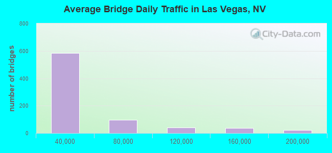
- 28,103,074Total average daily traffic
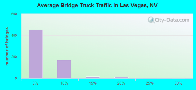
- 1,412,722Total average daily truck traffic
- National Bridge Inventory (NBI) Registered Bridges for Las Vegas
- No street view available for this location
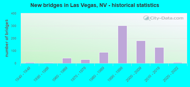
- New bridges - historical statistics
- 11930-1939
- 61940-1949
- 41950-1959
- 431960-1969
- 301970-1979
- 891980-1989
- 3021990-1999
- 1822000-2009
- 1292010-2019
- 72020-2022

- Reconstructed bridges - Historical Statistics
- 11940-1949
- 01950-1959
- 21960-1969
- 01970-1979
- 01980-1989
- 31990-1999
- 152000-2009
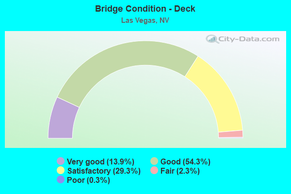
- Bridge Condition - Deck
- 13.9%Very good
- 54.3%Good
- 29.3%Satisfactory
- 2.3%Fair
- 0.3%Poor
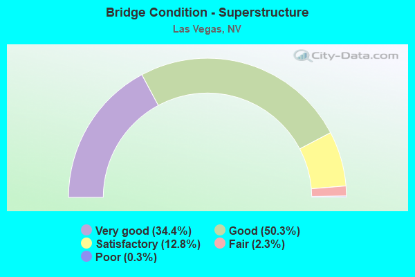
- Bridge Condition - Superstructure
- 34.4%Very good
- 50.3%Good
- 12.8%Satisfactory
- 2.3%Fair
- 0.3%Poor
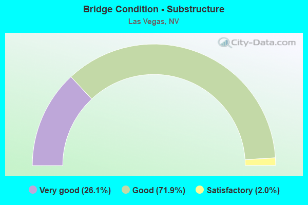
- Bridge Condition - Substructure
- 26.1%Very good
- 71.9%Good
- 2.0%Satisfactory
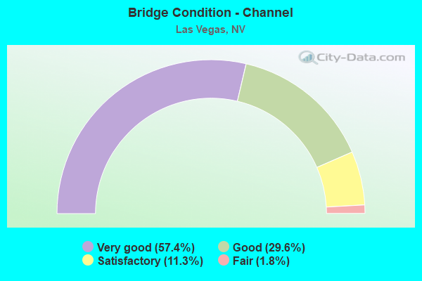
- Bridge Condition - Channel
- 57.4%Very good
- 29.6%Good
- 11.3%Satisfactory
- 1.8%Fair
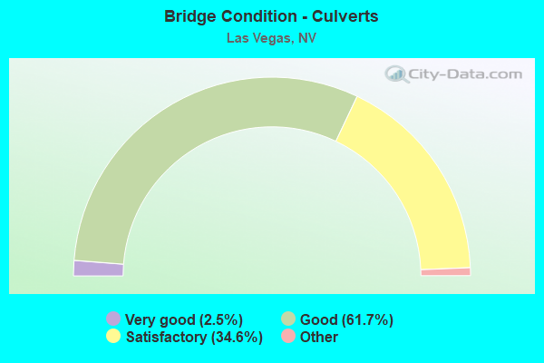
- Bridge Condition - Culverts
- 2.5%Very good
- 61.7%Good
- 34.6%Satisfactory
- 1.3%Fair
- 0.4%Poor
Find on map >> Show street view
Structure Number: B2908, Location: WEST LAS VEGAS (Lat: 36.067092, Lng: -115.306900), Route carried "on" structure: County highway , Year Built: 2007, Status: Open, Structure Length: 0.61m (2.00ft), Average Daily Traffic: 1,000 (year 2017), Truck Traffic: 3%, Average Future Daily Traffic: 2,068 (year 2040), Features Intersected: CHANNEL, Facility Carried by Structure: ZIEGLER AVE
Minimum Vertical Clearance: 30+ m (98+ ft), Kilometerpoint: 0.000, Lanes on structure: 2, Owner: County Highway Agency, Approaching Roadway Width: 11.1m (36.4ft), Material/Design: Concrete, Design/Construction: Culvert, Number Of Spans In Main Unit: 1, Length of Maximum Span: 6.1m (20.0ft), Curb or Sidewalk Widths: Left: 1.4m (4.6ft), Right: 1.7m (5.6ft)
Condition: Channel: Very good, Culverts: Good, Operating Rating: 32.7 metric tons, Method Used To Determine Operating Rating: Field evaluation and documented engineering judgment, Inventory Rating: 19.6 metric tons, Method Used To Determine Inventory Rating: Field evaluation and documented engineering judgment, Structural Evaluation: Somewhat better than minimum adequacy, Waterway Adequacy: Equal to present desirable criteria, Approach Roadway Alignment: Equal to present desirable criteria, Designated Inspection Frequency: Every 24 months, Inspection Date: October 2021
Find on map >> Show street view
Structure Number: B2909, Location: WEST LAS VEGAS (Lat: 36.079661, Lng: -115.306681), Route carried "on" structure: County highway , Year Built: 2007, Status: Open, Structure Length: 1.50m (4.92ft), Average Daily Traffic: 1,500 (year 2017), Truck Traffic: 3%, Average Future Daily Traffic: 3,102 (year 2040), Design Load: HS 20, Features Intersected: CHANNEL, Facility Carried by Structure: S GRAND CANYON DR
Minimum Vertical Clearance: 30+ m (98+ ft), Kilometerpoint: 0.000, Lanes on structure: 5, Owner: County Highway Agency, Approaching Roadway Width: 21.4m (70.2ft), Skew: 2 degrees, Material/Design: Concrete, Design/Construction: Culvert, Number Of Spans In Main Unit: 5, Length of Maximum Span: 2.6m (8.5ft), Curb or Sidewalk Widths: Left: 1.7m (5.6ft), Right: 1.7m (5.6ft)
Condition: Channel: Very good, Culverts: Good, Operating Rating: 60.4 metric tons, Method Used To Determine Operating Rating: Load Factor (LF), Inventory Rating: 36.2 metric tons, Method Used To Determine Inventory Rating: Load Factor (LF), Structural Evaluation: Better than present minimum criteria, Waterway Adequacy: Equal to present desirable criteria, Approach Roadway Alignment: Equal to present desirable criteria, Designated Inspection Frequency: Every 48 months, Inspection Date: October 2021
Find on map >> Show street view
Structure Number: B292, Location: SW LAS VEGAS (Lat: 36.022350, Lng: -115.297811), Route carried "on" structure: County highway , Year Built: 2005, Status: Open, Structure Length: 4.64m (15.22ft), Average Daily Traffic: 14,100 (year 2017), Truck Traffic: 3%, Average Future Daily Traffic: 29,160 (year 2040), Design Load: HS 20, Features Intersected: WASH, Facility Carried by Structure: S. FORT APACHE RD
Minimum Vertical Clearance: 30+ m (98+ ft), Kilometerpoint: 0.000, Lanes on structure: 2, Owner: County Highway Agency, Approaching Roadway Width: 8.8m (28.9ft), Skew: 1 degrees, Material/Design: Concrete, Design/Construction: Culvert, Number Of Spans In Main Unit: 13, Length of Maximum Span: 3.1m (10.2ft)
Condition: Channel: Good, Culverts: Good, Operating Rating: 45.5 metric tons, Method Used To Determine Operating Rating: Load Factor (LF), Inventory Rating: 27.2 metric tons, Method Used To Determine Inventory Rating: Load Factor (LF), Structural Evaluation: Equal to present minimum criteria, Waterway Adequacy: Equal to present desirable criteria, Approach Roadway Alignment: Equal to present desirable criteria, Designated Inspection Frequency: Every 24 months, Inspection Date: Febuary 2020
Find on map >> Show street view
Structure Number: B2935, Location: NW of LAS VEGAS (Lat: 36.247950, Lng: -115.247136), Route carried "on" structure: City street , Year Built: 2012, Status: Open, Structure Length: 0.98m (3.22ft), Average Daily Traffic: 12,000 (year 2017), Truck Traffic: 1%, Average Future Daily Traffic: 24,817 (year 2040), Design Load: HS 20, Features Intersected: DRY WASH, Facility Carried by Structure: W LONE MOUNTAIN RD
Minimum Vertical Clearance: 30+ m (98+ ft), Kilometerpoint: 0.000, Lanes on structure: 2, Owner: City or Municipal Highway Agency, Approaching Roadway Width: 9.1m (29.9ft), Material/Design: Concrete, Design/Construction: Culvert, Number Of Spans In Main Unit: 2, Length of Maximum Span: 4.6m (15.1ft), Curb or Sidewalk Widths: Left: 2.0m (6.6ft), Right: 0.0m
Condition: Channel: Good, Culverts: Very good, Operating Rating: 32.7 metric tons, Method Used To Determine Operating Rating: Field evaluation and documented engineering judgment, Inventory Rating: 19.6 metric tons, Method Used To Determine Inventory Rating: Field evaluation and documented engineering judgment, Structural Evaluation: Meets minimum limits, Waterway Adequacy: Equal to present desirable criteria, Approach Roadway Alignment: Equal to present desirable criteria, Designated Inspection Frequency: Every 24 months, Inspection Date: Febuary 2020
Find on map >> Show street view
Structure Number: B2946, Location: 250' N OF BLUE DIAMOND (Lat: 36.023353, Lng: -115.243422), Route carried "on" structure: City street 595, Year Built: 2009, Status: Open, Structure Length: 1.03m (3.38ft), Average Daily Traffic: 26,000 (year 2017), Truck Traffic: 1%, Average Future Daily Traffic: 53,771 (year 2040), Design Load: HS 20+Mod, Features Intersected: DRY WASH, Facility Carried by Structure: RAINBOW BLVD
Minimum Vertical Clearance: 30+ m (98+ ft), Kilometerpoint: 0.076, Lanes on structure: 5, Owner: County Highway Agency, Approaching Roadway Width: 19.0m (62.3ft), Skew: 20 degrees, Material/Design: Concrete, Design/Construction: Culvert, Number Of Spans In Main Unit: 3, Length of Maximum Span: 3.0m (9.8ft)
Condition: Channel: Fair, Culverts: Good, Operating Rating: 53.5 metric tons, Method Used To Determine Operating Rating: Load Factor (LF), Inventory Rating: 31.9 metric tons, Method Used To Determine Inventory Rating: Load Factor (LF), Structural Evaluation: Better than present minimum criteria, Waterway Adequacy: Better than present minimum criteria, Approach Roadway Alignment: Equal to present desirable criteria, Designated Inspection Frequency: Every 24 months, Inspection Date: September 2021
Find on map >> Show street view
Structure Number: B2964, Location: SOUTHWEST OF L.V (Lat: 36.000019, Lng: -115.261878), Route carried "on" structure: County highway , Year Built: 2010, Status: Open, Structure Length: 1.61m (5.28ft), Average Daily Traffic: 5,000 (year 2017), Truck Traffic: 1%, Average Future Daily Traffic: 7,900 (year 2040), Features Intersected: CHANNEL, Facility Carried by Structure: SOUTH BUFFALO DRIV
Minimum Vertical Clearance: 30+ m (98+ ft), Kilometerpoint: 0.000, Lanes on structure: 5, Owner: County Highway Agency, Approaching Roadway Width: 27.0m (88.6ft), Material/Design: Concrete, Design/Construction: Culvert, Number Of Spans In Main Unit: 3, Length of Maximum Span: 5.1m (16.7ft)
Condition: Channel: Very good, Culverts: Satisfactory, Operating Rating: 32.7 metric tons, Method Used To Determine Operating Rating: Field evaluation and documented engineering judgment, Inventory Rating: 19.6 metric tons, Method Used To Determine Inventory Rating: Field evaluation and documented engineering judgment, Structural Evaluation: Somewhat better than minimum adequacy, Waterway Adequacy: Equal to present desirable criteria, Approach Roadway Alignment: Equal to present desirable criteria, Designated Inspection Frequency: Every 24 months, Inspection Date: September 2021
Find on map >> Show street view
Structure Number: B2966, Location: SOUTHWEST OF LAS VEGAS (Lat: 36.019406, Lng: -115.261272), Route carried "on" structure: County highway , Year Built: 2010, Status: Open, Structure Length: 2.00m (6.56ft), Average Daily Traffic: 11,000 (year 2017), Truck Traffic: 2%, Average Future Daily Traffic: 7,900 (year 2040), Features Intersected: DRY WASH, Facility Carried by Structure: SOUTH BUFFALO DRIV
Minimum Vertical Clearance: 30+ m (98+ ft), Kilometerpoint: 0.000, Lanes on structure: 7, Owner: County Highway Agency, Approaching Roadway Width: 27.0m (88.6ft), Skew: 21 degrees, Material/Design: Concrete, Design/Construction: Culvert, Number Of Spans In Main Unit: 1, Length of Maximum Span: 20.0m (65.6ft), Curb or Sidewalk Widths: Left: 1.6m (5.2ft), Right: 1.6m (5.2ft)
Condition: Channel: Good, Culverts: Good, Operating Rating: 32.7 metric tons, Method Used To Determine Operating Rating: Field evaluation and documented engineering judgment, Inventory Rating: 19.6 metric tons, Method Used To Determine Inventory Rating: Field evaluation and documented engineering judgment, Structural Evaluation: Meets minimum limits, Waterway Adequacy: Equal to present desirable criteria, Approach Roadway Alignment: Equal to present desirable criteria, Designated Inspection Frequency: Every 24 months, Inspection Date: September 2021
Find on map >> Show street view
Structure Number: B2968, Location: SOUTHWEST OF L.V (Lat: 36.046197, Lng: -115.261122), Route carried "on" structure: County highway , Year Built: 2010, Status: Open, Structure Length: 1.04m (3.41ft), Average Daily Traffic: 4,000 (year 2017), Truck Traffic: 4%, Average Future Daily Traffic: 20,000 (year 2040), Features Intersected: DRY WASH, Facility Carried by Structure: S. BUFALLO DRIVE
Minimum Vertical Clearance: 30+ m (98+ ft), Kilometerpoint: 0.000, Lanes on structure: 4, Owner: County Highway Agency, Approaching Roadway Width: 15.2m (49.9ft), Skew: 1 degrees, Material/Design: Concrete, Design/Construction: Culvert, Number Of Spans In Main Unit: 3, Length of Maximum Span: 3.0m (9.8ft), Curb or Sidewalk Widths: Left: 0.0m, Right: 1.6m (5.2ft)
Condition: Channel: Good, Culverts: Good, Operating Rating: 32.7 metric tons, Method Used To Determine Operating Rating: Field evaluation and documented engineering judgment, Inventory Rating: 19.6 metric tons, Method Used To Determine Inventory Rating: Field evaluation and documented engineering judgment, Structural Evaluation: Somewhat better than minimum adequacy, Waterway Adequacy: Equal to present desirable criteria, Approach Roadway Alignment: Equal to present desirable criteria, Designated Inspection Frequency: Every 24 months, Inspection Date: October 2021
Find on map >> Show street view
Structure Number: B2981, Location: SW OF I 15N & US 93 (Lat: 36.382972, Lng: -114.896153), Route carried "on" structure: County highway , Year Built: 2010, Status: Open, Structure Length: 1.65m (5.41ft), Average Daily Traffic: 3,300 (year 2017), Truck Traffic: 10%, Average Future Daily Traffic: 5,000 (year 2040), Design Load: HS 20+Mod, Features Intersected: DRY WASH, Facility Carried by Structure: APEX GREAT BASIN
Minimum Vertical Clearance: 30+ m (98+ ft), Kilometerpoint: 0.000, Lanes on structure: 3, Owner: State Highway Agency, Approaching Roadway Width: 14.8m (48.6ft), Material/Design: Concrete, Design/Construction: Culvert, Number Of Spans In Main Unit: 4, Length of Maximum Span: 3.6m (11.8ft)
Condition: Channel: Very good, Culverts: Good, Operating Rating: 42.4 metric tons, Method Used To Determine Operating Rating: Load and Resistance Factor (LRFR), Inventory Rating: 32.7 metric tons, Method Used To Determine Inventory Rating: Load and Resistance Factor (LRFR), Structural Evaluation: Better than present minimum criteria, Waterway Adequacy: Equal to present desirable criteria, Approach Roadway Alignment: Equal to present minimum criteria, Designated Inspection Frequency: Every 48 months, Inspection Date: November 2020
Find on map >> Show street view
Structure Number: B2982, Location: SOUTHWEST L.V (Lat: 35.998208, Lng: -115.279861), Route carried "on" structure: County highway , Year Built: 2010, Status: Open, Structure Length: 0.61m (2.00ft), Average Daily Traffic: 5,000 (year 2017), Truck Traffic: 1%, Average Future Daily Traffic: 7,900 (year 2040), Design Load: HS 20, Features Intersected: CHANNEL, Facility Carried by Structure: WEST CACTUS AVE.
Minimum Vertical Clearance: 30+ m (98+ ft), Kilometerpoint: 0.000, Lanes on structure: 4, Owner: County Highway Agency, Approaching Roadway Width: 16.0m (52.5ft), Skew: 4 degrees, Material/Design: Concrete, Design/Construction: Culvert, Number Of Spans In Main Unit: 1, Length of Maximum Span: 6.1m (20.0ft)
Condition: Channel: Very good, Culverts: Satisfactory, Operating Rating: 42.4 metric tons, Method Used To Determine Operating Rating: Load Factor (LF), Inventory Rating: 25.4 metric tons, Method Used To Determine Inventory Rating: Load Factor (LF), Structural Evaluation: Equal to present minimum criteria, Waterway Adequacy: Equal to present desirable criteria, Approach Roadway Alignment: Equal to present desirable criteria, Designated Inspection Frequency: Every 24 months, Inspection Date: Febuary 2020
Find on map >> Show street view
Structure Number: B2983, Location: SW LAS VEGAS (Lat: 35.998033, Lng: -115.285606), Route carried "on" structure: County highway , Year Built: 2010, Status: Open, Structure Length: 0.73m (2.40ft), Average Daily Traffic: 5,000 (year 2017), Truck Traffic: 2%, Average Future Daily Traffic: 7,900 (year 2040), Design Load: HS 20, Features Intersected: CHANNEL, Facility Carried by Structure: WEST CACTUS AVE
Minimum Vertical Clearance: 30+ m (98+ ft), Kilometerpoint: 0.000, Lanes on structure: 4, Owner: County Highway Agency, Approaching Roadway Width: 14.3m (46.9ft), Skew: 4 degrees, Material/Design: Concrete, Design/Construction: Culvert, Number Of Spans In Main Unit: 1, Length of Maximum Span: 7.3m (24.0ft), Curb or Sidewalk Widths: Left: 1.6m (5.2ft), Right: 1.6m (5.2ft)
Condition: Channel: Very good, Culverts: Good, Operating Rating: 72.1 metric tons, Method Used To Determine Operating Rating: Load Factor (LF), Inventory Rating: 43.1 metric tons, Method Used To Determine Inventory Rating: Load Factor (LF), Structural Evaluation: Better than present minimum criteria, Waterway Adequacy: Equal to present desirable criteria, Approach Roadway Alignment: Equal to present desirable criteria, Designated Inspection Frequency: Every 48 months, Inspection Date: Febuary 2018
Find on map >> Show street view
Structure Number: B2984, Location: SOUTHWEST L.V (Lat: 35.999806, Lng: -115.289064), Route carried "on" structure: County highway , Year Built: 2010, Status: Open, Structure Length: 0.61m (2.00ft), Average Daily Traffic: 5,000 (year 2017), Truck Traffic: 3%, Average Future Daily Traffic: 7,900 (year 2040), Design Load: HS 20, Features Intersected: DRY WASH, Facility Carried by Structure: EL CAPITAN WAY
Minimum Vertical Clearance: 30+ m (98+ ft), Kilometerpoint: 0.000, Lanes on structure: 4, Owner: County Highway Agency, Approaching Roadway Width: 21.0m (68.9ft), Material/Design: Concrete, Design/Construction: Culvert, Number Of Spans In Main Unit: 1, Length of Maximum Span: 6.1m (20.0ft), Curb or Sidewalk Widths: Left: 1.6m (5.2ft), Right: 0.0m
Condition: Channel: Good, Culverts: Good, Operating Rating: 87.4 metric tons, Method Used To Determine Operating Rating: Load Factor (LF), Inventory Rating: 52.5 metric tons, Method Used To Determine Inventory Rating: Load Factor (LF), Structural Evaluation: Better than present minimum criteria, Waterway Adequacy: Equal to present desirable criteria, Approach Roadway Alignment: Equal to present desirable criteria, Designated Inspection Frequency: Every 48 months, Inspection Date: Febuary 2018
Find on map >> Show street view
Structure Number: B2985, Location: SOUTHWEST L.V (Lat: 36.007831, Lng: -115.243569), Route carried "on" structure: County highway , Year Built: 2010, Status: Open, Structure Length: 0.85m (2.79ft), Average Daily Traffic: 18,000 (year 2017), Truck Traffic: 4%, Average Future Daily Traffic: 37,226 (year 2040), Design Load: HS 20, Features Intersected: DRY WASH, Facility Carried by Structure: S. RAINBOW BLVD
Minimum Vertical Clearance: 30+ m (98+ ft), Kilometerpoint: 0.000, Lanes on structure: 2, Owner: County Highway Agency, Approaching Roadway Width: 12.1m (39.7ft), Skew: 20 degrees, Material/Design: Concrete, Design/Construction: Culvert, Number Of Spans In Main Unit: 1, Length of Maximum Span: 8.5m (27.9ft)
Condition: Channel: Very good, Culverts: Good, Inventory Rating: 57.4 metric tons, Method Used To Determine Inventory Rating: Load Factor (LF), Structural Evaluation: Better than present minimum criteria, Waterway Adequacy: Equal to present desirable criteria, Approach Roadway Alignment: Equal to present desirable criteria, Designated Inspection Frequency: Every 48 months, Inspection Date: September 2021
Find on map >> Show street view
Structure Number: B2987, Location: SOUTHWEST L.V (Lat: 36.048419, Lng: -115.254878), Route carried "on" structure: County highway , Year Built: 2010, Status: Open, Structure Length: 1.08m (3.54ft), Average Daily Traffic: 8,600 (year 2017), Truck Traffic: 1%, Average Future Daily Traffic: 13,100 (year 2040), Design Load: HS 20, Features Intersected: BLUE DIAMOND WASH, Facility Carried by Structure: ROBINDALE ROAD
Minimum Vertical Clearance: 30+ m (98+ ft), Kilometerpoint: 0.000, Lanes on structure: 4, Owner: County Highway Agency, Approaching Roadway Width: 16.4m (53.8ft), Skew: 33 degrees, Material/Design: Concrete, Design/Construction: Culvert, Number Of Spans In Main Unit: 2, Length of Maximum Span: 4.2m (13.8ft), Curb or Sidewalk Widths: Left: 1.6m (5.2ft), Right: 1.6m (5.2ft)
Condition: Channel: Very good, Culverts: Satisfactory, Operating Rating: 64.3 metric tons, Method Used To Determine Operating Rating: Load Factor (LF), Inventory Rating: 36.2 metric tons, Method Used To Determine Inventory Rating: Load Factor (LF), Structural Evaluation: Equal to present minimum criteria, Waterway Adequacy: Equal to present desirable criteria, Approach Roadway Alignment: Equal to present desirable criteria, Designated Inspection Frequency: Every 48 months, Inspection Date: October 2021
Find on map >> Show street view
Structure Number: B2988, Location: SOUTHWEST L.V (Lat: 36.053094, Lng: -115.245347), Route carried "on" structure: County highway , Year Built: 2010, Status: Open, Structure Length: 1.61m (5.28ft), Average Daily Traffic: 575 (year 2017), Average Future Daily Traffic: 1,189 (year 2040), Design Load: HS 20, Features Intersected: BLUE DIAMOND WASH, Facility Carried by Structure: ROSANNE STREET
Minimum Vertical Clearance: 30+ m (98+ ft), Kilometerpoint: 0.000, Lanes on structure: 2, Owner: County Highway Agency, Approaching Roadway Width: 9.8m (32.2ft), Skew: 3 degrees, Material/Design: Concrete, Design/Construction: Culvert, Number Of Spans In Main Unit: 3, Length of Maximum Span: 4.2m (13.8ft), Curb or Sidewalk Widths: Left: 1.6m (5.2ft), Right: 0.0m
Condition: Channel: Very good, Culverts: Good, Operating Rating: 60.7 metric tons, Method Used To Determine Operating Rating: Load Factor (LF), Inventory Rating: 35.2 metric tons, Method Used To Determine Inventory Rating: Load Factor (LF), Structural Evaluation: Better than present minimum criteria, Waterway Adequacy: Equal to present desirable criteria, Approach Roadway Alignment: Equal to present desirable criteria, Designated Inspection Frequency: Every 48 months, Inspection Date: October 2021
Find on map >> Show street view
Structure Number: B2989, Location: SOUTHWEST L.V (Lat: 36.023975, Lng: -115.278947), Route carried "on" structure: County highway , Year Built: 2010, Status: Open, Structure Length: 1.43m (4.69ft), Average Daily Traffic: 7,500 (year 2017), Truck Traffic: 2%, Average Future Daily Traffic: 46,000 (year 2040), Design Load: HS 20, Features Intersected: WASH, Facility Carried by Structure: S. DURANGO DRIVE
Minimum Vertical Clearance: 30+ m (98+ ft), Kilometerpoint: 0.000, Lanes on structure: 2, Owner: County Highway Agency, Approaching Roadway Width: 27.1m (88.9ft), Material/Design: Concrete, Design/Construction: Culvert, Number Of Spans In Main Unit: 4, Length of Maximum Span: 3.4m (11.2ft), Curb or Sidewalk Widths: Left: 1.6m (5.2ft), Right: 0.0m
Condition: Channel: Good, Culverts: Good, Operating Rating: 39.8 metric tons, Method Used To Determine Operating Rating: Load Factor (LF), Inventory Rating: 23.8 metric tons, Method Used To Determine Inventory Rating: Load Factor (LF), Structural Evaluation: Somewhat better than minimum adequacy, Waterway Adequacy: Equal to present desirable criteria, Approach Roadway Alignment: Equal to present desirable criteria, Designated Inspection Frequency: Every 24 months, Inspection Date: Febuary 2020
Find on map >> Show street view
Structure Number: B3045, Location: NW LAS VEGAS (Lat: 36.188728, Lng: -115.255633), Route carried "on" structure: City street , Year Built: 1992, Status: Open, Structure Length: 0.64m (2.10ft), Average Daily Traffic: 11,300 (year 2017), Average Future Daily Traffic: 23,370 (year 2040), Design Load: HS 20, Features Intersected: BUFFALO CHANNEL, Facility Carried by Structure: W VEGAS DRIVE
Minimum Vertical Clearance: 30+ m (98+ ft), Kilometerpoint: 0.000, Lanes on structure: 4, Owner: City or Municipal Highway Agency, Approaching Roadway Width: 17.7m (58.1ft), Skew: 20 degrees, Material/Design: Concrete, Design/Construction: Culvert, Number Of Spans In Main Unit: 2, Length of Maximum Span: 3.0m (9.8ft), Curb or Sidewalk Widths: Left: 1.7m (5.6ft), Right: 1.7m (5.6ft), Curb-To-Curb Width: 17.7m (58.1ft), Out-to-Out Width: 26.8m (87.9ft)
Condition: Channel: Very good, Culverts: Good, Operating Rating: 56.8 metric tons, Method Used To Determine Operating Rating: Load Factor (LF), Inventory Rating: 33.9 metric tons, Method Used To Determine Inventory Rating: Load Factor (LF), Structural Evaluation: Better than present minimum criteria, Deck Geometry: Somewhat better than minimum adequacy, Waterway Adequacy: Equal to present desirable criteria, Approach Roadway Alignment: Equal to present desirable criteria, Designated Inspection Frequency: Every 48 months, Inspection Date: Febuary 2021
Find on map >> Show street view
Structure Number: B3046, Location: NW LAS VEGAS (Lat: 36.196239, Lng: -115.255781), Route carried "on" structure: City street , Year Built: 1992, Status: Open, Structure Length: 0.67m (2.20ft), Average Daily Traffic: 37,000 (year 2017), Truck Traffic: 1%, Average Future Daily Traffic: 26,886 (year 2040), Design Load: HS 20, Features Intersected: BUFFALO CHANNEL, Facility Carried by Structure: W LAKE MEAD BLVD
Minimum Vertical Clearance: 30+ m (98+ ft), Kilometerpoint: 0.000, Lanes on structure: 7, Owner: City or Municipal Highway Agency, Approaching Roadway Width: 26.8m (87.9ft), Skew: 21 degrees, Material/Design: Concrete, Design/Construction: Culvert, Number Of Spans In Main Unit: 2, Length of Maximum Span: 3.0m (9.8ft), Curb or Sidewalk Widths: Left: 1.7m (5.6ft), Right: 1.7m (5.6ft), Curb-To-Curb Width: 26.8m (87.9ft), Out-to-Out Width: 30.8m (101.0ft)
Condition: Channel: Very good, Culverts: Good, Operating Rating: 62.9 metric tons, Method Used To Determine Operating Rating: Load Factor (LF), Inventory Rating: 37.6 metric tons, Method Used To Determine Inventory Rating: Load Factor (LF), Structural Evaluation: Better than present minimum criteria, Deck Geometry: Somewhat better than minimum adequacy, Waterway Adequacy: Equal to present desirable criteria, Approach Roadway Alignment: Equal to present desirable criteria, Designated Inspection Frequency: Every 48 months, Inspection Date: Febuary 2021
Find on map >> Show street view
Structure Number: B3047, Location: NW LAS VEGAS (Lat: 36.203458, Lng: -115.255956), Route carried "on" structure: City street , Year Built: 1992, Status: Open, Structure Length: 0.64m (2.10ft), Average Daily Traffic: 13,000 (year 2017), Truck Traffic: 1%, Average Future Daily Traffic: 26,886 (year 2040), Design Load: HS 20, Features Intersected: BUFFALO CHANNEL, Facility Carried by Structure: W SMOKE RANCH RD
Minimum Vertical Clearance: 30+ m (98+ ft), Kilometerpoint: 0.000, Lanes on structure: 5, Owner: City or Municipal Highway Agency, Approaching Roadway Width: 25.0m (82.0ft), Skew: 20 degrees, Material/Design: Concrete, Design/Construction: Culvert, Number Of Spans In Main Unit: 2, Length of Maximum Span: 3.0m (9.8ft), Curb or Sidewalk Widths: Left: 1.4m (4.6ft), Right: 1.4m (4.6ft), Curb-To-Curb Width: 25.0m (82.0ft), Out-to-Out Width: 30.5m (100.1ft)
Condition: Channel: Very good, Culverts: Good, Operating Rating: 62.5 metric tons, Method Used To Determine Operating Rating: Load Factor (LF), Inventory Rating: 37.6 metric tons, Method Used To Determine Inventory Rating: Load Factor (LF), Structural Evaluation: Better than present minimum criteria, Deck Geometry: Superior to present desirable criteria, Waterway Adequacy: Equal to present desirable criteria, Approach Roadway Alignment: Equal to present desirable criteria, Designated Inspection Frequency: Every 48 months, Inspection Date: Febuary 2021
Find on map >> Show street view
Structure Number: B3048, Location: NW LAS VEGAS (Lat: 36.209947, Lng: -115.254878), Route carried "on" structure: City street , Year Built: 1992, Status: Open, Structure Length: 0.64m (2.10ft), Average Daily Traffic: 2,800 (year 2017), Average Future Daily Traffic: 5,791 (year 2040), Design Load: HS 20, Features Intersected: BUFFALO CHANNEL, Facility Carried by Structure: PEAK DRIVE
Minimum Vertical Clearance: 30+ m (98+ ft), Kilometerpoint: 0.000, Lanes on structure: 4, Owner: City or Municipal Highway Agency, Approaching Roadway Width: 21.0m (68.9ft), Material/Design: Concrete, Design/Construction: Culvert, Number Of Spans In Main Unit: 2, Length of Maximum Span: 3.0m (9.8ft), Curb or Sidewalk Widths: Left: 1.6m (5.2ft), Right: 1.1m (3.6ft), Curb-To-Curb Width: 21.0m (68.9ft), Out-to-Out Width: 24.7m (81.0ft)
Condition: Channel: Very good, Culverts: Good, Operating Rating: 83.5 metric tons, Method Used To Determine Operating Rating: Load Factor (LF), Inventory Rating: 49.9 metric tons, Method Used To Determine Inventory Rating: Load Factor (LF), Structural Evaluation: Better than present minimum criteria, Deck Geometry: Superior to present desirable criteria, Waterway Adequacy: Equal to present desirable criteria, Approach Roadway Alignment: Equal to present desirable criteria, Designated Inspection Frequency: Every 48 months, Inspection Date: Febuary 2021
Find on map >> Show street view
Structure Number: B305, Location: SOUTHWEST OF LAS VEGAS (Lat: 35.995222, Lng: -115.252594), Route carried "on" structure: County highway , Year Built: 2010, Status: Open, Structure Length: 0.61m (2.00ft), Average Daily Traffic: 230 (year 2017), Average Future Daily Traffic: 476 (year 2040), Design Load: HS 20, Features Intersected: CHANNEL, Facility Carried by Structure: PEPPER BOX AVE
Minimum Vertical Clearance: 30+ m (98+ ft), Kilometerpoint: 0.000, Lanes on structure: 2, Owner: County Highway Agency, Approaching Roadway Width: 10.4m (34.1ft), Material/Design: Concrete, Design/Construction: Culvert, Number Of Spans In Main Unit: 1, Length of Maximum Span: 6.1m (20.0ft), Curb or Sidewalk Widths: Left: 1.2m (3.9ft), Right: 0.0m
Condition: Channel: Very good, Culverts: Good, Inventory Rating: 60.4 metric tons, Method Used To Determine Inventory Rating: Load Factor (LF), Structural Evaluation: Better than present minimum criteria, Waterway Adequacy: Equal to present desirable criteria, Approach Roadway Alignment: Equal to present desirable criteria, Designated Inspection Frequency: Every 48 months, Inspection Date: Febuary 2021
Find on map >> Show street view
Structure Number: B3071, Location: SOUTHWEST OF LAS VEGAS (Lat: 36.095478, Lng: -115.196933), Route carried "on" structure: City street , Year Built: 2011, Status: Open, Structure Length: 0.87m (2.85ft), Average Daily Traffic: 115 (year 2017), Average Future Daily Traffic: 238 (year 2040), Design Load: HS 20, Features Intersected: TROPICANA WASH, Facility Carried by Structure: SCHIRLLS STREET
Minimum Vertical Clearance: 30+ m (98+ ft), Kilometerpoint: 0.000, Lanes on structure: 2, Owner: County Highway Agency, Approaching Roadway Width: 9.8m (32.2ft), Skew: 1 degrees, Material/Design: Concrete, Design/Construction: Culvert, Number Of Spans In Main Unit: 2, Length of Maximum Span: 4.3m (14.1ft), Curb or Sidewalk Widths: Left: 1.5m (4.9ft), Right: 0.0m
Condition: Channel: Very good, Culverts: Good, Operating Rating: 32.7 metric tons, Method Used To Determine Operating Rating: Field evaluation and documented engineering judgment, Inventory Rating: 19.6 metric tons, Method Used To Determine Inventory Rating: Field evaluation and documented engineering judgment, Structural Evaluation: Somewhat better than minimum adequacy, Waterway Adequacy: Equal to present desirable criteria, Approach Roadway Alignment: Equal to present desirable criteria, Designated Inspection Frequency: Every 24 months, Inspection Date: January 2020
Find on map >> Show street view
Structure Number: B3072, Location: NE LAS VEGAS OFF US 93 (Lat: 36.428989, Lng: -114.951242), Route carried "on" structure: County highway , Year Built: 2012, Status: Open, Structure Length: 1.04m (3.41ft), Average Daily Traffic: 3,300 (year 2017), Truck Traffic: 40%, Average Future Daily Traffic: 5,000 (year 2040), Design Load: HS 20, Features Intersected: DRY WASH, Facility Carried by Structure: APEX POWER PARKWAY
Minimum Vertical Clearance: 30+ m (98+ ft), Kilometerpoint: 0.000, Lanes on structure: 3, Owner: County Highway Agency, Approaching Roadway Width: 10.1m (33.1ft), Material/Design: Concrete, Design/Construction: Culvert, Number Of Spans In Main Unit: 3, Length of Maximum Span: 3.0m (9.8ft), Curb-To-Curb Width: 10.1m (33.1ft), Out-to-Out Width: 19.5m (64.0ft)
Condition: Channel: Good, Culverts: Very good, Operating Rating: 35.2 metric tons, Method Used To Determine Operating Rating: Load and Resistance Factor (LRFR), Inventory Rating: 27.0 metric tons, Method Used To Determine Inventory Rating: Load and Resistance Factor (LRFR), Structural Evaluation: Equal to present minimum criteria, Deck Geometry: High priority of replacement, Waterway Adequacy: Equal to present desirable criteria, Approach Roadway Alignment: Equal to present desirable criteria, Designated Inspection Frequency: Every 24 months, Inspection Date: September 2021
Find on map >> Show street view
Structure Number: B3073, Location: SOUTHWEST OF LAS VEGAS (Lat: 36.069897, Lng: -115.194711), Route carried "on" structure: City street , Year Built: 1997, Status: Open, Structure Length: 0.75m (2.46ft), Average Daily Traffic: 115 (year 2017), Average Future Daily Traffic: 238 (year 2040), Design Load: HS 20, Features Intersected: DUCK CREEK, Facility Carried by Structure: WAGON TRAIL@HINSON
Minimum Vertical Clearance: 30+ m (98+ ft), Kilometerpoint: 0.000, Lanes on structure: 2, Owner: County Highway Agency, Approaching Roadway Width: 14.9m (48.9ft), Material/Design: Concrete, Design/Construction: Culvert, Number Of Spans In Main Unit: 2, Length of Maximum Span: 3.7m (12.1ft), Curb or Sidewalk Widths: Left: 0.0m, Right: 1.5m (4.9ft)
Condition: Channel: Good, Culverts: Very good, Operating Rating: 37.6 metric tons, Method Used To Determine Operating Rating: Load Factor (LF), Inventory Rating: 22.5 metric tons, Method Used To Determine Inventory Rating: Load Factor (LF), Structural Evaluation: Equal to present minimum criteria, Waterway Adequacy: Better than present minimum criteria, Approach Roadway Alignment: Better than present minimum criteria, Designated Inspection Frequency: Every 24 months, Inspection Date: January 2020
Find on map >> Show street view
Structure Number: B3074, Location: SOUTHWEST OF LAS VEGAS (Lat: 36.039106, Lng: -115.188050), Route carried "on" structure: County highway , Year Built: 2006, Status: Open, Structure Length: 1.01m (3.31ft), Average Daily Traffic: 5,200 (year 2017), Truck Traffic: 1%, Average Future Daily Traffic: 10,754 (year 2040), Design Load: HS 20, Features Intersected: SHELBOURNE CHANNEL, Facility Carried by Structure: DEAN MARTIN DRIVE
Minimum Vertical Clearance: 30+ m (98+ ft), Kilometerpoint: 0.000, Lanes on structure: 8, Owner: County Highway Agency, Approaching Roadway Width: 34.4m (112.9ft), Skew: 20 degrees, Material/Design: Concrete, Design/Construction: Culvert, Number Of Spans In Main Unit: 4, Length of Maximum Span: 2.1m (6.9ft), Curb or Sidewalk Widths: Left: 1.5m (4.9ft), Right: 1.5m (4.9ft)
Condition: Channel: Very good, Culverts: Good, Operating Rating: 58.4 metric tons, Method Used To Determine Operating Rating: Load Factor (LF), Inventory Rating: 34.9 metric tons, Method Used To Determine Inventory Rating: Load Factor (LF), Structural Evaluation: Better than present minimum criteria, Waterway Adequacy: Equal to present desirable criteria, Approach Roadway Alignment: Equal to present desirable criteria, Designated Inspection Frequency: Every 48 months, Inspection Date: Febuary 2021
Find on map >> Show street view
Structure Number: B3075, Location: SOUTHEAST OF LAS VEGAS (Lat: 36.017053, Lng: -115.160028), Route carried "on" structure: County highway , Year Built: 2003, Status: Open, Structure Length: 1.19m (3.90ft), Average Daily Traffic: 1,000 (year 2017), Average Future Daily Traffic: 2,068 (year 2040), Design Load: HS 20, Features Intersected: DUCK CREEK, Facility Carried by Structure: E RICHMAR AVE
Minimum Vertical Clearance: 30+ m (98+ ft), Kilometerpoint: 0.000, Lanes on structure: 2, Owner: County Highway Agency, Approaching Roadway Width: 12.2m (40.0ft), Material/Design: Concrete, Design/Construction: Culvert, Number Of Spans In Main Unit: 3, Length of Maximum Span: 3.7m (12.1ft), Curb or Sidewalk Widths: Left: 1.7m (5.6ft), Right: 1.7m (5.6ft), Curb-To-Curb Width: 12.2m (40.0ft), Out-to-Out Width: 21.9m (71.9ft)
Condition: Channel: Very good, Culverts: Good, Operating Rating: 73.7 metric tons, Method Used To Determine Operating Rating: Load Factor (LF), Inventory Rating: 44.1 metric tons, Method Used To Determine Inventory Rating: Load Factor (LF), Structural Evaluation: Better than present minimum criteria, Deck Geometry: Equal to present desirable criteria, Waterway Adequacy: Equal to present desirable criteria, Approach Roadway Alignment: Equal to present desirable criteria, Designated Inspection Frequency: Every 48 months, Inspection Date: Febuary 2021
Find on map >> Show street view
Structure Number: B3076, Location: SOUTHEAST OF LAS VEGAS (Lat: 36.017161, Lng: -115.163589), Route carried "on" structure: County highway , Year Built: 2008, Status: Open, Structure Length: 1.40m (4.59ft), Average Daily Traffic: 850 (year 2017), Truck Traffic: 1%, Average Future Daily Traffic: 1,758 (year 2040), Design Load: HS 20, Features Intersected: DUCK CREEK, Facility Carried by Structure: GILLESPIE @RICHMAR
Minimum Vertical Clearance: 30+ m (98+ ft), Kilometerpoint: 0.000, Lanes on structure: 3, Owner: County Highway Agency, Approaching Roadway Width: 18.9m (62.0ft), Skew: 9 degrees, Material/Design: Concrete, Design/Construction: Culvert, Number Of Spans In Main Unit: 2, Length of Maximum Span: 6.7m (22.0ft), Curb or Sidewalk Widths: Left: 1.7m (5.6ft), Right: 1.7m (5.6ft), Curb-To-Curb Width: 18.9m (62.0ft), Out-to-Out Width: 164.9m (541.0ft)
Condition: Channel: Good, Culverts: Satisfactory, Operating Rating: 32.7 metric tons, Method Used To Determine Operating Rating: Field evaluation and documented engineering judgment, Inventory Rating: 19.6 metric tons, Method Used To Determine Inventory Rating: Field evaluation and documented engineering judgment, Structural Evaluation: Somewhat better than minimum adequacy, Deck Geometry: Superior to present desirable criteria, Waterway Adequacy: Equal to present desirable criteria, Approach Roadway Alignment: Equal to present desirable criteria, Designated Inspection Frequency: Every 24 months, Inspection Date: Febuary 2021
Find on map >> Show street view
Structure Number: B3077, Location: SOUTH EAST OF LAS VEGAS (Lat: 36.013456, Lng: -115.162406), Route carried "on" structure: County highway , Year Built: 2008, Status: Open, Structure Length: 1.04m (3.41ft), Average Daily Traffic: 4,500 (year 2017), Truck Traffic: 1%, Average Future Daily Traffic: 9,307 (year 2040), Design Load: HS 20, Features Intersected: DUCK CREEK, Facility Carried by Structure: SILVERADO RANCH BL
Minimum Vertical Clearance: 30+ m (98+ ft), Kilometerpoint: 0.000, Lanes on structure: 7, Owner: County Highway Agency, Approaching Roadway Width: 29.0m (95.1ft), Skew: 20 degrees, Material/Design: Concrete, Design/Construction: Culvert, Number Of Spans In Main Unit: 2, Length of Maximum Span: 4.9m (16.1ft), Curb or Sidewalk Widths: Left: 1.7m (5.6ft), Right: 1.7m (5.6ft), Curb-To-Curb Width: 29.0m (95.1ft), Out-to-Out Width: 48.8m (160.1ft)
Condition: Channel: Very good, Culverts: Good, Operating Rating: 32.7 metric tons, Method Used To Determine Operating Rating: Field evaluation and documented engineering judgment, Inventory Rating: 19.6 metric tons, Method Used To Determine Inventory Rating: Field evaluation and documented engineering judgment, Structural Evaluation: Somewhat better than minimum adequacy, Deck Geometry: Somewhat better than minimum adequacy, Waterway Adequacy: Equal to present desirable criteria, Approach Roadway Alignment: Equal to present desirable criteria, Designated Inspection Frequency: Every 24 months, Inspection Date: Febuary 2021
Find on map >> Show street view
Structure Number: B3078, Location: SOUTH EAST OF LAS VEGAS (Lat: 36.013572, Lng: -115.166058), Route carried "on" structure: County highway , Year Built: 2008, Status: Open, Structure Length: 1.52m (4.99ft), Average Daily Traffic: 5,000 (year 2017), Truck Traffic: 1%, Average Future Daily Traffic: 10,341 (year 2040), Design Load: HS 20, Features Intersected: DUCK CREEK, Facility Carried by Structure: SILVERADO RANCH BL
Minimum Vertical Clearance: 30+ m (98+ ft), Kilometerpoint: 0.000, Lanes on structure: 6, Owner: County Highway Agency, Approaching Roadway Width: 27.1m (88.9ft), Material/Design: Concrete, Design/Construction: Culvert, Number Of Spans In Main Unit: 2, Length of Maximum Span: 7.3m (24.0ft), Curb or Sidewalk Widths: Left: 1.7m (5.6ft), Right: 1.7m (5.6ft), Curb-To-Curb Width: 27.1m (88.9ft), Out-to-Out Width: 82.0m (269.0ft)
Condition: Channel: Very good, Culverts: Good, Operating Rating: 68.6 metric tons, Method Used To Determine Operating Rating: Load Factor (LF), Inventory Rating: 41.1 metric tons, Method Used To Determine Inventory Rating: Load Factor (LF), Structural Evaluation: Better than present minimum criteria, Deck Geometry: Better than present minimum criteria, Waterway Adequacy: Equal to present desirable criteria, Approach Roadway Alignment: Equal to present desirable criteria, Designated Inspection Frequency: Every 48 months, Inspection Date: Febuary 2021
Find on map >> Show street view
Structure Number: B3079, Location: SOUTHEAST OF LAS VEGAS (Lat: 36.007522, Lng: -115.170250), Route carried "on" structure: County highway , Year Built: 2008, Status: Open, Structure Length: 1.37m (4.49ft), Average Daily Traffic: 1,000 (year 2017), Truck Traffic: 1%, Average Future Daily Traffic: 2,068 (year 2040), Design Load: HS 20, Features Intersected: DUCK CREEK CHANNEL, Facility Carried by Structure: S GILES ST/PYLE AV
Minimum Vertical Clearance: 30+ m (98+ ft), Kilometerpoint: 0.000, Lanes on structure: 2, Owner: County Highway Agency, Approaching Roadway Width: 8.2m (26.9ft), Skew: 9 degrees, Material/Design: Concrete, Design/Construction: Culvert, Number Of Spans In Main Unit: 2, Length of Maximum Span: 6.7m (22.0ft)
Condition: Channel: Very good, Culverts: Good, Operating Rating: 32.7 metric tons, Method Used To Determine Operating Rating: Field evaluation and documented engineering judgment, Inventory Rating: 19.6 metric tons, Method Used To Determine Inventory Rating: Field evaluation and documented engineering judgment, Structural Evaluation: Somewhat better than minimum adequacy, Waterway Adequacy: Equal to present desirable criteria, Approach Roadway Alignment: Equal to present desirable criteria, Designated Inspection Frequency: Every 24 months, Inspection Date: Febuary 2021
Find on map >> Show street view
Structure Number: B308, Location: SOUTHEAST OF LAS VEGAS (Lat: 36.008275, Lng: -115.170197), Route carried "on" structure: County highway , Year Built: 2008, Status: Open, Structure Length: 0.73m (2.40ft), Average Daily Traffic: 230 (year 2017), Average Future Daily Traffic: 476 (year 2040), Design Load: HS 20, Features Intersected: DUCK CREEK CHANNEL, Facility Carried by Structure: S GILES ST/JO RAE
Minimum Vertical Clearance: 30+ m (98+ ft), Kilometerpoint: 0.000, Lanes on structure: 2, Owner: County Highway Agency, Approaching Roadway Width: 7.9m (25.9ft), Material/Design: Concrete, Design/Construction: Culvert, Number Of Spans In Main Unit: 1, Length of Maximum Span: 6.7m (22.0ft)
Condition: Channel: Very good, Culverts: Good, Operating Rating: 40.5 metric tons, Method Used To Determine Operating Rating: Load Factor (LF), Inventory Rating: 24.1 metric tons, Method Used To Determine Inventory Rating: Load Factor (LF), Structural Evaluation: Equal to present minimum criteria, Waterway Adequacy: Equal to present desirable criteria, Approach Roadway Alignment: Equal to present desirable criteria, Designated Inspection Frequency: Every 24 months, Inspection Date: Febuary 2021
Find on map >> Show street view
Structure Number: B3081, Location: SOUTHEAST OF LAS VEGAS (Lat: 36.006550, Lng: -115.162292), Route carried "on" structure: County highway , Year Built: 2006, Status: Open, Structure Length: 1.02m (3.35ft), Average Daily Traffic: 9,900 (year 2017), Truck Traffic: 1%, Average Future Daily Traffic: 12,400 (year 2040), Design Load: HS 20, Features Intersected: DUCK CREEK CHANNEL, Facility Carried by Structure: E PYLE AVENUE
Minimum Vertical Clearance: 30+ m (98+ ft), Kilometerpoint: 0.000, Lanes on structure: 3, Owner: County Highway Agency, Approaching Roadway Width: 12.2m (40.0ft), Material/Design: Concrete, Design/Construction: Culvert, Number Of Spans In Main Unit: 4, Length of Maximum Span: 2.4m (7.9ft), Curb or Sidewalk Widths: Left: 1.5m (4.9ft), Right: 0.0m, Curb-To-Curb Width: 12.2m (40.0ft), Out-to-Out Width: 18.3m (60.0ft)
Condition: Channel: Good, Culverts: Good, Operating Rating: 32.7 metric tons, Method Used To Determine Operating Rating: Field evaluation and documented engineering judgment, Inventory Rating: 19.6 metric tons, Method Used To Determine Inventory Rating: Field evaluation and documented engineering judgment, Structural Evaluation: Meets minimum limits, Deck Geometry: Meets minimum limits, Waterway Adequacy: Equal to present desirable criteria, Approach Roadway Alignment: Equal to present desirable criteria, Designated Inspection Frequency: Every 24 months, Inspection Date: Febuary 2021
Find on map >> Show street view
Structure Number: B3082, Location: SOUTHEAST LAS VEGAS (Lat: 36.003789, Lng: -115.161394), Route carried "on" structure: County highway , Year Built: 2007, Status: Open, Structure Length: 0.82m (2.69ft), Average Daily Traffic: 345 (year 2017), Average Future Daily Traffic: 714 (year 2040), Design Load: HS 20, Features Intersected: DUCK CREEK WASH, Facility Carried by Structure: LA CIENAGA
Minimum Vertical Clearance: 30+ m (98+ ft), Kilometerpoint: 0.000, Lanes on structure: 2, Owner: County Highway Agency, Approaching Roadway Width: 9.8m (32.2ft), Skew: 4 degrees, Material/Design: Concrete, Design/Construction: Culvert, Number Of Spans In Main Unit: 3, Length of Maximum Span: 2.4m (7.9ft)
Condition: Channel: Good, Culverts: Good, Operating Rating: 32.7 metric tons, Method Used To Determine Operating Rating: Field evaluation and documented engineering judgment, Inventory Rating: 19.6 metric tons, Method Used To Determine Inventory Rating: Field evaluation and documented engineering judgment, Structural Evaluation: Somewhat better than minimum adequacy, Waterway Adequacy: Better than present minimum criteria, Approach Roadway Alignment: Equal to present desirable criteria, Designated Inspection Frequency: Every 24 months, Inspection Date: September 2021
Find on map >> Show street view
Structure Number: B3083, Location: SOUTHEAST LAS VEGAS (Lat: 36.002950, Lng: -115.161056), Route carried "on" structure: County highway , Year Built: 2007, Status: Open, Structure Length: 0.67m (2.20ft), Average Daily Traffic: 500 (year 2017), Average Future Daily Traffic: 1,034 (year 2040), Design Load: HS 20, Features Intersected: DUCK CREEK WASH, Facility Carried by Structure: EAST FRIAS AVENUE
Minimum Vertical Clearance: 30+ m (98+ ft), Kilometerpoint: 0.000, Lanes on structure: 2, Owner: County Highway Agency, Approaching Roadway Width: 12.2m (40.0ft), Material/Design: Concrete, Design/Construction: Culvert, Number Of Spans In Main Unit: 2, Length of Maximum Span: 3.0m (9.8ft), Curb or Sidewalk Widths: Left: 1.7m (5.6ft), Right: 2.0m (6.6ft), Curb-To-Curb Width: 12.2m (40.0ft), Out-to-Out Width: 19.5m (64.0ft)
Condition: Channel: Good, Culverts: Good, Operating Rating: 32.7 metric tons, Method Used To Determine Operating Rating: Field evaluation and documented engineering judgment, Inventory Rating: 19.6 metric tons, Method Used To Determine Inventory Rating: Field evaluation and documented engineering judgment, Structural Evaluation: Somewhat better than minimum adequacy, Deck Geometry: Equal to present desirable criteria, Waterway Adequacy: Better than present minimum criteria, Approach Roadway Alignment: Equal to present desirable criteria, Designated Inspection Frequency: Every 24 months, Inspection Date: September 2021
Find on map >> Show street view
Structure Number: B3084, Location: SOUTHEAST LAS VEGAS (Lat: 35.999350, Lng: -115.160461), Route carried "on" structure: County highway , Year Built: 2008, Status: Open, Structure Length: 1.20m (3.94ft), Average Daily Traffic: 3,000 (year 2017), Average Future Daily Traffic: 14,600 (year 2040), Design Load: HS 20, Features Intersected: DUCK CREEK WASH, Facility Carried by Structure: EAST CACTUS AVE.
Minimum Vertical Clearance: 30+ m (98+ ft), Kilometerpoint: 0.000, Lanes on structure: 2, Owner: County Highway Agency, Approaching Roadway Width: 15.2m (49.9ft), Skew: 2 degrees, Material/Design: Concrete, Design/Construction: Culvert, Number Of Spans In Main Unit: 2, Length of Maximum Span: 5.8m (19.0ft), Curb or Sidewalk Widths: Left: 0.0m, Right: 1.7m (5.6ft), Curb-To-Curb Width: 15.2m (49.9ft), Out-to-Out Width: 28.3m (92.8ft)
Condition: Channel: Very good, Culverts: Good, Operating Rating: 32.7 metric tons, Method Used To Determine Operating Rating: Field evaluation and documented engineering judgment, Inventory Rating: 19.6 metric tons, Method Used To Determine Inventory Rating: Field evaluation and documented engineering judgment, Structural Evaluation: Somewhat better than minimum adequacy, Deck Geometry: Superior to present desirable criteria, Waterway Adequacy: Better than present minimum criteria, Approach Roadway Alignment: Equal to present desirable criteria, Designated Inspection Frequency: Every 24 months, Inspection Date: October 2021
Find on map >> Show street view
Structure Number: B3086, Location: SOUTHEAST OF LAS VEGAS (Lat: 35.992000, Lng: -115.159906), Route carried "on" structure: County highway , Year Built: 2008, Status: Open, Structure Length: 3.02m (9.91ft), Average Daily Traffic: 2,100 (year 2017), Average Future Daily Traffic: 4,343 (year 2040), Design Load: HS 20, Features Intersected: DUCK CREEK WASH, Facility Carried by Structure: E ERIE AVE
Minimum Vertical Clearance: 30+ m (98+ ft), Kilometerpoint: 0.000, Lanes on structure: 2, Owner: County Highway Agency, Approaching Roadway Width: 9.8m (32.2ft), Material/Design: Concrete, Design/Construction: Culvert, Number Of Spans In Main Unit: 18, Length of Maximum Span: 1.2m (3.9ft), Curb-To-Curb Width: 9.8m (32.2ft), Out-to-Out Width: 19.2m (63.0ft)
Condition: Channel: Satisfactory, Culverts: Good, Operating Rating: 32.7 metric tons, Method Used To Determine Operating Rating: Field evaluation and documented engineering judgment, Inventory Rating: 19.6 metric tons, Method Used To Determine Inventory Rating: Field evaluation and documented engineering judgment, Structural Evaluation: Somewhat better than minimum adequacy, Deck Geometry: Meets minimum limits, Waterway Adequacy: Equal to present desirable criteria, Approach Roadway Alignment: Equal to present desirable criteria, Designated Inspection Frequency: Every 24 months, Inspection Date: Febuary 2021
Find on map >> Show street view
Structure Number: B3087, Location: SOUTHEAST OF LAS VEGAS (Lat: 36.022244, Lng: -115.154572), Route carried "on" structure: County highway , Year Built: 2008, Status: Open, Structure Length: 2.50m (8.20ft), Average Daily Traffic: 3,200 (year 2017), Truck Traffic: 1%, Average Future Daily Traffic: 6,618 (year 2040), Design Load: HS 20, Features Intersected: DUCK CREEK WASH, Facility Carried by Structure: BERMUDA ROAD
Minimum Vertical Clearance: 30+ m (98+ ft), Kilometerpoint: 0.000, Lanes on structure: 6, Owner: County Highway Agency, Approaching Roadway Width: 27.1m (88.9ft), Material/Design: Concrete, Design/Construction: Culvert, Number Of Spans In Main Unit: 5, Length of Maximum Span: 5.2m (17.1ft), Curb or Sidewalk Widths: Left: 1.8m (5.9ft), Right: 1.8m (5.9ft), Curb-To-Curb Width: 27.1m (88.9ft), Out-to-Out Width: 35.1m (115.2ft)
Condition: Channel: Very good, Culverts: Good, Operating Rating: 32.7 metric tons, Method Used To Determine Operating Rating: Field evaluation and documented engineering judgment, Inventory Rating: 19.6 metric tons, Method Used To Determine Inventory Rating: Field evaluation and documented engineering judgment, Structural Evaluation: Somewhat better than minimum adequacy, Deck Geometry: Better than present minimum criteria, Waterway Adequacy: Equal to present desirable criteria, Approach Roadway Alignment: Equal to present desirable criteria, Designated Inspection Frequency: Every 24 months, Inspection Date: Febuary 2021
Find on map >> Show street view
Structure Number: B3091, Location: SOUTHEAST LAS VEGAS (Lat: 36.020819, Lng: -115.163422), Route carried "on" structure: County highway , Year Built: 2000, Status: Open, Structure Length: 0.76m (2.49ft), Average Daily Traffic: 850 (year 2017), Average Future Daily Traffic: 1,758 (year 2040), Design Load: HS 20, Features Intersected: DUCK CREEK WASH, Facility Carried by Structure: GILLESPIE & SERENE
Minimum Vertical Clearance: 30+ m (98+ ft), Kilometerpoint: 0.000, Lanes on structure: 2, Owner: County Highway Agency, Approaching Roadway Width: 21.0m (68.9ft), Material/Design: Concrete, Design/Construction: Culvert, Number Of Spans In Main Unit: 3, Length of Maximum Span: 2.4m (7.9ft), Curb or Sidewalk Widths: Left: 1.7m (5.6ft), Right: 1.7m (5.6ft)
Condition: Channel: Very good, Culverts: Good, Inventory Rating: 83.1 metric tons, Method Used To Determine Inventory Rating: Load Factor (LF), Structural Evaluation: Better than present minimum criteria, Waterway Adequacy: Equal to present desirable criteria, Approach Roadway Alignment: Equal to present desirable criteria, Designated Inspection Frequency: Every 48 months, Inspection Date: Febuary 2020
Find on map >> Show street view
Structure Number: B3121, Location: SOUTHEAST OF LAS VEGAS (Lat: 36.053569, Lng: -115.124917), Route carried "on" structure: County highway , Year Built: 2010, Status: Open, Structure Length: 2.29m (7.51ft), Average Daily Traffic: 575 (year 2017), Average Future Daily Traffic: 1,189 (year 2040), Design Load: HS 20, Features Intersected: DUCK CREEK, Facility Carried by Structure: ELDORADO LN
Minimum Vertical Clearance: 30+ m (98+ ft), Kilometerpoint: 0.000, Lanes on structure: 2, Owner: County Highway Agency, Approaching Roadway Width: 14.9m (48.9ft), Material/Design: Concrete, Design/Construction: Culvert, Number Of Spans In Main Unit: 5, Length of Maximum Span: 4.3m (14.1ft), Curb or Sidewalk Widths: Left: 1.5m (4.9ft), Right: 1.5m (4.9ft)
Condition: Channel: Very good, Culverts: Good, Operating Rating: 32.7 metric tons, Method Used To Determine Operating Rating: Field evaluation and documented engineering judgment, Inventory Rating: 19.6 metric tons, Method Used To Determine Inventory Rating: Field evaluation and documented engineering judgment, Structural Evaluation: Somewhat better than minimum adequacy, Waterway Adequacy: Equal to present desirable criteria, Approach Roadway Alignment: Equal to present desirable criteria, Designated Inspection Frequency: Every 24 months, Inspection Date: Febuary 2020
Find on map >> Show street view
Structure Number: B314, Location: SOUTH OF US 50 (Lat: 36.166356, Lng: -115.192375), Route carried "on" structure: City street , Year Built: 1990, Status: Open, Structure Length: 0.64m (2.10ft), Average Daily Traffic: 26,000 (year 2017), Truck Traffic: 1%, Average Future Daily Traffic: 53,771 (year 2040), Design Load: HS 20, Features Intersected: LAS VEGAS WASH, Facility Carried by Structure: VALLEY VIEW @ ALTA
Minimum Vertical Clearance: 30+ m (98+ ft), Kilometerpoint: 0.000, Lanes on structure: 6, Owner: City or Municipal Highway Agency, Approaching Roadway Width: 19.8m (65.0ft), Skew: 4 degrees, Material/Design: Concrete, Design/Construction: Culvert, Number Of Spans In Main Unit: 2, Length of Maximum Span: 3.0m (9.8ft), Curb or Sidewalk Widths: Left: 1.7m (5.6ft), Right: 1.7m (5.6ft)
Condition: Channel: Very good, Culverts: Satisfactory, Operating Rating: 42.4 metric tons, Method Used To Determine Operating Rating: Load Factor (LF), Inventory Rating: 25.4 metric tons, Method Used To Determine Inventory Rating: Load Factor (LF), Structural Evaluation: Equal to present minimum criteria, Waterway Adequacy: Better than present minimum criteria, Approach Roadway Alignment: Equal to present desirable criteria, Designated Inspection Frequency: Every 24 months, Inspection Date: Febuary 2020
Find on map >> Show street view
Structure Number: B3141, Location: SOUTHWEST OF LAS VEGAS (Lat: 35.995633, Lng: -115.185647), Route carried "on" structure: County highway , Year Built: 2013, Status: Open, Structure Length: 1.22m (4.00ft), Average Daily Traffic: 575 (year 2017), Average Future Daily Traffic: 1,189 (year 2040), Design Load: HS 20, Features Intersected: DUCK CREEK, Facility Carried by Structure: POLARIS AVE.
Minimum Vertical Clearance: 30+ m (98+ ft), Kilometerpoint: 0.000, Lanes on structure: 2, Owner: County Highway Agency, Approaching Roadway Width: 14.6m (47.9ft), Material/Design: Concrete, Design/Construction: Culvert, Number Of Spans In Main Unit: 3, Length of Maximum Span: 3.7m (12.1ft), Curb or Sidewalk Widths: Left: 1.7m (5.6ft), Right: 1.7m (5.6ft)
Condition: Channel: Very good, Culverts: Good, Operating Rating: 32.7 metric tons, Method Used To Determine Operating Rating: Field evaluation and documented engineering judgment, Inventory Rating: 19.6 metric tons, Method Used To Determine Inventory Rating: Field evaluation and documented engineering judgment, Structural Evaluation: Somewhat better than minimum adequacy, Waterway Adequacy: Equal to present desirable criteria, Approach Roadway Alignment: Equal to present desirable criteria, Designated Inspection Frequency: Every 24 months, Inspection Date: Febuary 2020
Find on map >> Show street view
Structure Number: B3143, Location: SOUTH OF SILVERADO (Lat: 35.999072, Lng: -115.181481), Route carried "on" structure: County highway , Year Built: 2013, Status: Open, Structure Length: 1.13m (3.71ft), Average Daily Traffic: 9,700 (year 2017), Truck Traffic: 5%, Average Future Daily Traffic: 20,061 (year 2040), Design Load: HL 93, Features Intersected: DUCK CREEK, Facility Carried by Structure: CACTUS AVE. & I 15
Minimum Vertical Clearance: 30+ m (98+ ft), Kilometerpoint: 0.000, Lanes on structure: 7, Base Highway Network: Yes, Owner: State Highway Agency, Approaching Roadway Width: 29.0m (95.1ft), Skew: 24 degrees, Material/Design: Concrete, Design/Construction: Culvert, Number Of Spans In Main Unit: 3, Length of Maximum Span: 3.7m (12.1ft), Curb or Sidewalk Widths: Left: 1.7m (5.6ft), Right: 1.7m (5.6ft)
Condition: Channel: Very good, Culverts: Good, Operating Rating: 35.6 metric tons, Method Used To Determine Operating Rating: Load and Resistance Factor (LRFR), Inventory Rating: 27.4 metric tons, Method Used To Determine Inventory Rating: Load and Resistance Factor (LRFR), Structural Evaluation: Equal to present minimum criteria, Waterway Adequacy: Equal to present desirable criteria, Approach Roadway Alignment: Equal to present desirable criteria, Designated Inspection Frequency: Every 24 months, Inspection Date: October 2020
Find on map >> Show street view
Structure Number: B3144, Location: SOUTH OF SILVERADO (Lat: 35.999083, Lng: -115.181611), Route carried "on" structure: County highway , Year Built: 2013, Status: Open, Structure Length: 1.13m (3.71ft), Average Daily Traffic: 9,700 (year 2017), Truck Traffic: 2%, Average Future Daily Traffic: 20,061 (year 2040), Design Load: HL 93, Features Intersected: DUCK CREEK, Facility Carried by Structure: CACTUS AVENUE
Minimum Vertical Clearance: 30+ m (98+ ft), Kilometerpoint: 0.000, Lanes on structure: 9, Owner: State Highway Agency, Approaching Roadway Width: 28.0m (91.9ft), Skew: 20 degrees, Material/Design: Concrete, Design/Construction: Culvert, Number Of Spans In Main Unit: 3, Length of Maximum Span: 3.7m (12.1ft), Curb or Sidewalk Widths: Left: 1.7m (5.6ft), Right: 1.7m (5.6ft)
Condition: Channel: Very good, Culverts: Good, Operating Rating: 40.5 metric tons, Method Used To Determine Operating Rating: Load and Resistance Factor (LRFR), Inventory Rating: 31.3 metric tons, Method Used To Determine Inventory Rating: Load and Resistance Factor (LRFR), Structural Evaluation: Better than present minimum criteria, Waterway Adequacy: Equal to present desirable criteria, Approach Roadway Alignment: Equal to present desirable criteria, Designated Inspection Frequency: Every 24 months, Inspection Date: October 2020
Find on map >> Show street view
Structure Number: B315, Location: SOUTH OF SILVERADO (Lat: 36.007236, Lng: -115.180411), Route carried "on" structure: Interstate 15, Year Built: 2013, Status: Open, Structure Length: 1.31m (4.30ft), Average Daily Traffic: 59,000 (year 2017), Truck Traffic: 25%, Average Future Daily Traffic: 122,019 (year 2040), Design Load: HL 93, Features Intersected: DUCK CREEK
Minimum Vertical Clearance: 30+ m (98+ ft), Kilometerpoint: 49.809, Lanes on structure: 8, Base Highway Network: Yes, Owner: State Highway Agency, Approaching Roadway Width: 23.8m (78.1ft), Skew: 30 degrees, Material/Design: Concrete, Design/Construction: Culvert, Number Of Spans In Main Unit: 3, Length of Maximum Span: 4.9m (16.1ft)
Condition: Channel: Good, Culverts: Good, Operating Rating: 32.7 metric tons, Method Used To Determine Operating Rating: Field evaluation and documented engineering judgment, Inventory Rating: 19.6 metric tons, Method Used To Determine Inventory Rating: Field evaluation and documented engineering judgment, Structural Evaluation: Meets minimum limits, Waterway Adequacy: Equal to present desirable criteria, Approach Roadway Alignment: Superior to present desirable criteria, Designated Inspection Frequency: Every 24 months, Inspection Date: Febuary 2021
Find on map >> Show street view
Structure Number: B3159, Location: 3.3 miles west of I 15 (Lat: 35.998611, Lng: -115.237611), Route carried "on" structure: City street , Year Built: 2014, Status: Open, Structure Length: 0.73m (2.40ft), Average Daily Traffic: 7,700 (year 2017), Average Future Daily Traffic: 10,000 (year 2040), Design Load: HS 20, Features Intersected: WASH, Facility Carried by Structure: WEST CACTUS AVE.
Minimum Vertical Clearance: 30+ m (98+ ft), Kilometerpoint: 0.000, Lanes on structure: 4, Owner: County Highway Agency, Approaching Roadway Width: 26.2m (86.0ft), Material/Design: Concrete, Design/Construction: Culvert, Number Of Spans In Main Unit: 1, Length of Maximum Span: 7.3m (24.0ft), Curb or Sidewalk Widths: Left: 1.7m (5.6ft), Right: 1.7m (5.6ft)
Condition: Channel: Very good, Culverts: Very good, Operating Rating: 32.7 metric tons, Method Used To Determine Operating Rating: Field evaluation and documented engineering judgment, Inventory Rating: 19.6 metric tons, Method Used To Determine Inventory Rating: Field evaluation and documented engineering judgment, Structural Evaluation: Meets minimum limits, Waterway Adequacy: Equal to present desirable criteria, Approach Roadway Alignment: Equal to present desirable criteria, Designated Inspection Frequency: Every 24 months, Inspection Date: September 2021
Find on map >> Show street view
Structure Number: B3192, Location: SW OF LV-ENTERPRISE (Lat: 36.017489, Lng: -115.270453), Route carried "on" structure: County highway , Year Built: 2012, Status: Open, Structure Length: 0.67m (2.20ft), Average Daily Traffic: 5,000 (year 2017), Truck Traffic: 1%, Average Future Daily Traffic: 7,900 (year 2040), Design Load: HS 20, Features Intersected: PED TRAIL WAY/WATER WAY, Facility Carried by Structure: S. CIMARRON ROAD
Minimum Vertical Clearance: 30+ m (98+ ft), Kilometerpoint: 0.000, Lanes on structure: 3, Owner: County Highway Agency, Approaching Roadway Width: 16.2m (53.1ft), Material/Design: Concrete, Design/Construction: Culvert, Number Of Spans In Main Unit: 2, Length of Maximum Span: 3.0m (9.8ft), Curb or Sidewalk Widths: Left: 1.7m (5.6ft), Right: 1.7m (5.6ft)
Condition: Channel: Very good, Culverts: Good, Operating Rating: 42.4 metric tons, Method Used To Determine Operating Rating: Load and Resistance Factor (LRFR), Inventory Rating: 32.7 metric tons, Method Used To Determine Inventory Rating: Load and Resistance Factor (LRFR), Structural Evaluation: Better than present minimum criteria, Waterway Adequacy: Equal to present desirable criteria, Approach Roadway Alignment: Equal to present desirable criteria, Designated Inspection Frequency: Every 48 months, Inspection Date: December 2019
Find on map >> Show street view
Structure Number: B3195, Location: WEST LAS VEGAS (Lat: 36.178572, Lng: -115.250900), Route carried "on" structure: City street , Year Built: 2010, Status: Open, Structure Length: 0.61m (2.00ft), Average Daily Traffic: 5,800 (year 2017), Average Future Daily Traffic: 11,995 (year 2040), Design Load: HS 20+Mod, Features Intersected: BONANZA PED TRAIL, Facility Carried by Structure: TENAYA WAY
Minimum Vertical Clearance: 30+ m (98+ ft), Kilometerpoint: 0.000, Lanes on structure: 2, Owner: City or Municipal Highway Agency, Approaching Roadway Width: 14.3m (46.9ft), Material/Design: Concrete, Design/Construction: Culvert, Number Of Spans In Main Unit: 1, Length of Maximum Span: 6.1m (20.0ft), Curb or Sidewalk Widths: Left: 3.0m (9.8ft), Right: 1.4m (4.6ft)
Condition: Culverts: Good, Operating Rating: 32.7 metric tons, Method Used To Determine Operating Rating: Load Factor (LF), Inventory Rating: 19.6 metric tons, Method Used To Determine Inventory Rating: Load Factor (LF), Structural Evaluation: Meets minimum limits, Approach Roadway Alignment: Equal to present desirable criteria, Designated Inspection Frequency: Every 24 months, Inspection Date: Febuary 2020