Bridge Statistics for Las Vegas, Nevada (NV)
Condition, Traffic, Stress, Structural Evaluation, Project Costs
- National Bridge Inventory (NBI) Statistics
- 793Number of bridges
- 12,585ft / 3,836mTotal length
- $111,427,000Total costs
- 28,103,074Total average daily traffic
- 1,412,722Total average daily truck traffic
- National Bridge Inventory (NBI) Registered Bridges for Las Vegas
- No street view available for this location
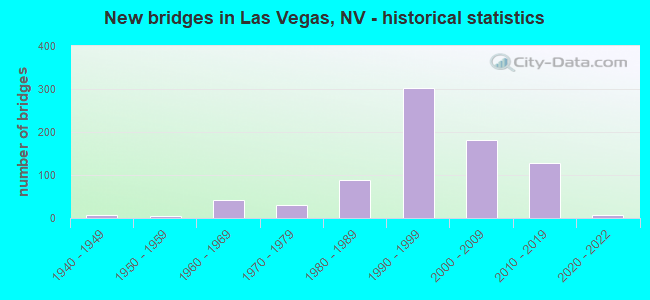
- New bridges - historical statistics
- 11930-1939
- 61940-1949
- 41950-1959
- 431960-1969
- 301970-1979
- 891980-1989
- 3021990-1999
- 1822000-2009
- 1292010-2019
- 72020-2022

- Reconstructed bridges - Historical Statistics
- 11940-1949
- 01950-1959
- 21960-1969
- 01970-1979
- 01980-1989
- 31990-1999
- 152000-2009
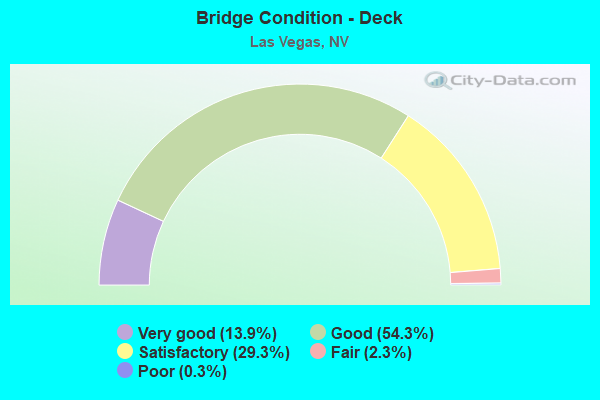
- Bridge Condition - Deck
- 13.9%Very good
- 54.3%Good
- 29.3%Satisfactory
- 2.3%Fair
- 0.3%Poor
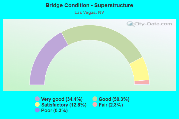
- Bridge Condition - Superstructure
- 34.4%Very good
- 50.3%Good
- 12.8%Satisfactory
- 2.3%Fair
- 0.3%Poor
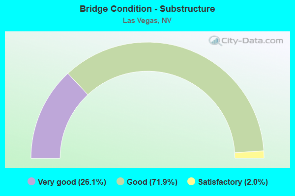
- Bridge Condition - Substructure
- 26.1%Very good
- 71.9%Good
- 2.0%Satisfactory
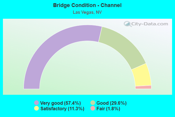
- Bridge Condition - Channel
- 57.4%Very good
- 29.6%Good
- 11.3%Satisfactory
- 1.8%Fair
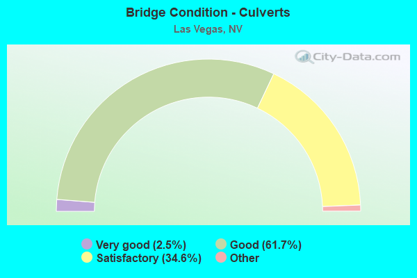
- Bridge Condition - Culverts
- 2.5%Very good
- 61.7%Good
- 34.6%Satisfactory
- 1.3%Fair
- 0.4%Poor
Find on map >> Show street view
Structure Number: I1444, Location: LAS VEGAS (Lat: 36.158764, Lng: -115.091636), Route carried "under" structure: State highway 159, Year Built: 1986, Structure Length: 0. m, Average Daily Traffic: 66,300 (year 2009), Truck Traffic: 3%, Features Intersected: SR587 CHARLESTON AV, Facility Carried by Structure: I 515
Minimum Vertical Clearance: 5.03m (16.50ft), Kilometerpoint: 52.112, Lanes on structure: 6, Lanes under structure: 9, Material/Design: Steel, Design/Construction: Box Beam or Girders - Multiple, Length of Maximum Span: 57.3m (188.0ft)
Find on map >> Show street view
Structure Number: I1449, Location: LAS VEGAS (Lat: 36.135828, Lng: -115.090319), Route carried "under" structure: State highway 582, Year Built: 1986, Structure Length: 0. m, Average Daily Traffic: 41,500 (year 2009), Truck Traffic: 3%, Features Intersected: US 93, Facility Carried by Structure: I 515, US95, US93
Minimum Vertical Clearance: 5.03m (16.50ft), Kilometerpoint: 118.747, Lanes on structure: 6, Lanes under structure: 10, Material/Design: Steel continuous, Design/Construction: Stringer/Multi-beam, Length of Maximum Span: 56.7m (186.0ft)
Find on map >> Show street view
Structure Number: I1452, Location: LAS VEGAS (Lat: 36.114964, Lng: -115.082786), Route carried "under" structure: State highway 592, Year Built: 1986, Structure Length: 0. m, Average Daily Traffic: 54,100 (year 2009), Truck Traffic: 3%, Features Intersected: SR592 FLAMINGO RD, Facility Carried by Structure: I 515, US95, US93
Minimum Vertical Clearance: 5.30m (17.39ft), Kilometerpoint: 15.432, Lanes on structure: 7, Lanes under structure: 8, Material/Design: Prestressed concrete continuous, Design/Construction: Box Beam or Girders - Multiple, Length of Maximum Span: 47.9m (157.2ft)
Find on map >> Show street view
Structure Number: I1453, Location: LAS VEGAS (Lat: 36.100278, Lng: -115.081794), Route carried "under" structure: State highway 593, Year Built: 1987, Structure Length: 0. m, Average Daily Traffic: 53,500 (year 2009), Truck Traffic: 3%, Features Intersected: SR593 TROPICANA BL, Facility Carried by Structure: I 515, US95, US93
Minimum Vertical Clearance: 4.88m (16.01ft), Kilometerpoint: 14.579, Lanes on structure: 6, Lanes under structure: 8, Material/Design: Prestressed concrete, Design/Construction: Box Beam or Girders - Multiple, Length of Maximum Span: 53.0m (173.9ft)
Find on map >> Show street view
Structure Number: I1456, Location: LAS VEGAS (Lat: 36.083231, Lng: -115.049614), Route carried "under" structure: Interstate 515, Year Built: 1987, Structure Length: 0. m, Average Daily Traffic: 69,265 (year 2009), Truck Traffic: 3%, Features Intersected: I 515, US95, US93, Facility Carried by Structure: SR594 RUSSELL RD
Minimum Vertical Clearance: 5.30m (17.39ft), Kilometerpoint: 0.000, Lanes on structure: 4, Lanes under structure: 6, Material/Design: Prestressed concrete continuous, Design/Construction: Box Beam or Girders - Multiple, Length of Maximum Span: 36.0m (118.1ft)
Find on map >> Show street view
Structure Number: I1464, Location: LAS VEGAS (Lat: 36.033478, Lng: -115.014244), Route carried "under" structure: State highway 564, Year Built: 1993, Structure Length: 0. m, Average Daily Traffic: 51,955 (year 2009), Truck Traffic: 3%, Features Intersected: SR564 LAKE MEAD PW, Facility Carried by Structure: I 515, US95, US93
Minimum Vertical Clearance: 5.00m (16.40ft), Kilometerpoint: 18.068, Lanes on structure: 8, Lanes under structure: 6, Material/Design: Prestressed concrete, Design/Construction: Box Beam or Girders - Multiple, Length of Maximum Span: 38.7m (127.0ft)
Find on map >> Show street view
Structure Number: I1745, Location: LAS VEGAS (Lat: 36.114514, Lng: -115.180431), Route carried "under" structure: Interstate 15, Year Built: 1985, Structure Length: 0. m, Average Daily Traffic: 106,410 (year 2009), Truck Traffic: 4%, Features Intersected: I 15, Facility Carried by Structure: SR592 FLAMINGO RD
Minimum Vertical Clearance: 6.10m (20.01ft), Kilometerpoint: 0.000, Lanes on structure: 8, Lanes under structure: 13, Material/Design: Steel, Design/Construction: Stringer/Multi-beam, Length of Maximum Span: 46.3m (151.9ft)
Find on map >> Show street view
Structure Number: I1845W, Location: LAS VEGAS (Lat: 36.177331, Lng: -115.243278), Route carried "under" structure: US 95, Year Built: 1989, Structure Length: 0. m, Average Daily Traffic: 137,000 (year 2009), Truck Traffic: 3%, Features Intersected: US 95 & RAINBOW
Minimum Vertical Clearance: 11.49m (37.70ft), Kilometerpoint: 17.236, Lanes on structure: 2, Lanes under structure: 19, Material/Design: Steel continuous, Design/Construction: Stringer/Multi-beam, Length of Maximum Span: 48.8m (160.1ft)
Find on map >> Show street view
Structure Number: I1845W, Location: LAS VEGAS (Lat: 36.177331, Lng: -115.243278), Route carried "under" structure: State highway 595, Year Built: 1989, Structure Length: 0. m, Average Daily Traffic: 52,450 (year 2009), Truck Traffic: 3%, Features Intersected: US 95 & RAINBOW, Facility Carried by Structure: RMP US95N-SMRLN PW
Minimum Vertical Clearance: 5.76m (18.90ft), Kilometerpoint: 17.236, Lanes on structure: 2, Lanes under structure: 19, Material/Design: Steel continuous, Design/Construction: Stringer/Multi-beam, Length of Maximum Span: 48.8m (160.1ft)
Find on map >> Show street view
Structure Number: I1854, Location: NORTHWEST OF LAS VEGAS (Lat: 36.362133, Lng: -115.351342), Route carried "under" structure: US 95, Year Built: 1994, Structure Length: 0. m, Average Daily Traffic: 6,120 (year 2009), Truck Traffic: 3%, Features Intersected: US 95, Facility Carried by Structure: SNOW MOUNTAIN RD
Minimum Vertical Clearance: 4.97m (16.31ft), Kilometerpoint: 0.000, Lanes on structure: 3, Lanes under structure: 4, Material/Design: Steel continuous, Design/Construction: Stringer/Multi-beam, Length of Maximum Span: 39.9m (130.9ft)
Find on map >> Show street view
Structure Number: I194, Location: CENTER STRUCTURE OVER 1-1 (Lat: 36.085956, Lng: -115.180664), Route carried "under" structure: Interstate 15, Year Built: 1993, Structure Length: 0. m, Average Daily Traffic: 78,365 (year 2009), Truck Traffic: 3%, Features Intersected: I 15, Facility Carried by Structure: SR594 RUSSELL RD
Minimum Vertical Clearance: 5.03m (16.50ft), Kilometerpoint: 58.564, Lanes on structure: 6, Lanes under structure: 10, Material/Design: Steel continuous, Design/Construction: Stringer/Multi-beam, Length of Maximum Span: 39.6m (129.9ft)
Find on map >> Show street view
Structure Number: I1940R, Location: LAS VEGAS (Lat: 36.083492, Lng: -115.179133), Route carried "under" structure: Ramp County highway , Year Built: 2001, Structure Length: 0. m, Average Daily Traffic: 1,000 (year 2009), Truck Traffic: 1%, Features Intersected: FRANK SINATRA DR, Facility Carried by Structure: RMP 15N TO RUSSELL
Minimum Vertical Clearance: 5.15m (16.90ft), Kilometerpoint: 0.000, Lanes on structure: 1, Lanes under structure: 3, Material/Design: Prestressed concrete, Design/Construction: Box Beam or Girders - Multiple, Length of Maximum Span: 45.7m (149.9ft)
Find on map >> Show street view
Structure Number: I1963, Location: HENDERSON (Lat: 36.024483, Lng: -115.084861), Route carried "under" structure: Interstate 215, Year Built: 1999, Structure Length: 0. m, Average Daily Traffic: 25,000 (year 2009), Features Intersected: I 215, Facility Carried by Structure: GREEN VALLEY PKWY
Minimum Vertical Clearance: 5.58m (18.31ft), Kilometerpoint: 0.000, Lanes on structure: 8, Lanes under structure: 6, Material/Design: Prestressed concrete continuous, Design/Construction: Box Beam or Girders - Multiple, Length of Maximum Span: 27.0m (88.6ft)
Find on map >> Show street view
Structure Number: I1966N, Location: LAS VEGAS (Lat: 36.023922, Lng: -115.118478), Route carried "under" structure: City street , Year Built: 1996, Structure Length: 0. m, Average Daily Traffic: 40,575 (year 2009), Truck Traffic: 3%, Features Intersected: EASTERN AV, Facility Carried by Structure: I 215N
Minimum Vertical Clearance: 5.03m (16.50ft), Kilometerpoint: 9.305, Lanes on structure: 4, Lanes under structure: 9, Material/Design: Prestressed concrete continuous, Design/Construction: Box Beam or Girders - Single/Spread, Length of Maximum Span: 32.0m (105.0ft)
Find on map >> Show street view
Structure Number: I1966S, Location: LAS VEGAS (Lat: 36.023694, Lng: -115.118461), Route carried "under" structure: City street , Year Built: 1996, Structure Length: 0. m, Average Daily Traffic: 40,575 (year 2009), Truck Traffic: 3%, Features Intersected: EASTERN AV, Facility Carried by Structure: I 215S
Minimum Vertical Clearance: 5.03m (16.50ft), Kilometerpoint: 0.000, Lanes on structure: 4, Lanes under structure: 9, Material/Design: Prestressed concrete continuous, Design/Construction: Box Beam or Girders - Single/Spread, Length of Maximum Span: 32.0m (105.0ft)
Find on map >> Show street view
Structure Number: I1969, Location: LAS VEGAS (Lat: 36.042633, Lng: -115.134025), Route carried "under" structure: Interstate 215, Year Built: 1996, Structure Length: 0. m, Average Daily Traffic: 109,600 (year 2009), Truck Traffic: 3%, Features Intersected: I 215, Facility Carried by Structure: WINDMILL LN
Minimum Vertical Clearance: 0.64m (2.10ft), Kilometerpoint: 0.000, Lanes on structure: 8, Lanes under structure: 6, Material/Design: Prestressed concrete continuous, Design/Construction: Box Beam or Girders - Single/Spread, Length of Maximum Span: 27.1m (88.9ft)
Find on map >> Show street view
Structure Number: I1972N, Location: LAS VEGAS (Lat: 36.057292, Lng: -115.140031), Route carried "under" structure: County highway , Year Built: 1995, Structure Length: 0. m, Average Daily Traffic: 25,450 (year 2009), Truck Traffic: 3%, Features Intersected: WARM SPRINGS RD, Facility Carried by Structure: I 215N
Minimum Vertical Clearance: 30+ m (98+ ft), Kilometerpoint: 1.716, Lanes on structure: 5, Lanes under structure: 7, Material/Design: Prestressed concrete, Design/Construction: Box Beam or Girders - Multiple, Length of Maximum Span: 58.8m (192.9ft)
Find on map >> Show street view
Structure Number: I1972R, Location: LAS VEGAS (Lat: 36.058797, Lng: -115.141075), Route carried "under" structure: City street , Year Built: 1995, Structure Length: 0. m, Average Daily Traffic: 12,700 (year 2009), Truck Traffic: 3%, Features Intersected: PARADISE RD, Facility Carried by Structure: RMP WARM SPR-215N
Minimum Vertical Clearance: 5.18m (16.99ft), Kilometerpoint: 0.000, Lanes on structure: 2, Lanes under structure: 4, Material/Design: Prestressed concrete, Design/Construction: Box Beam or Girders - Multiple, Length of Maximum Span: 52.4m (171.9ft)
Find on map >> Show street view
Structure Number: I1972S, Location: LAS VEGAS (Lat: 36.057294, Lng: -115.140381), Route carried "under" structure: County highway , Year Built: 1995, Structure Length: 0. m, Average Daily Traffic: 25,450 (year 2009), Truck Traffic: 3%, Features Intersected: WARM SPRINGS RD, Facility Carried by Structure: I 215S
Minimum Vertical Clearance: 30+ m (98+ ft), Kilometerpoint: 1.716, Lanes on structure: 6, Lanes under structure: 7, Material/Design: Prestressed concrete, Design/Construction: Box Beam or Girders - Multiple, Length of Maximum Span: 58.5m (191.9ft)
Find on map >> Show street view
Structure Number: I1973N, Location: LAS VEGAS (Lat: 36.062989, Lng: -115.149558), Route carried "under" structure: Ramp State highway 171, Year Built: 1994, Structure Length: 0. m, Average Daily Traffic: 44,000 (year 2009), Truck Traffic: 3%, Features Intersected: SR171 AIRPORT CONNECT, Facility Carried by Structure: I 215N
Minimum Vertical Clearance: 5.52m (18.11ft), Kilometerpoint: 2.816, Lanes on structure: 5, Lanes under structure: 4, Material/Design: Prestressed concrete, Design/Construction: Box Beam or Girders - Single/Spread, Length of Maximum Span: 45.4m (149.0ft)
Find on map >> Show street view
Structure Number: I1973R, Location: LAS VEGAS (Lat: 36.061847, Lng: -115.145417), Route carried "under" structure: Ramp City street , Year Built: 1994, Structure Length: 0. m, Average Daily Traffic: 6,900 (year 2009), Truck Traffic: 1%, Features Intersected: CITY ST RAMP, Facility Carried by Structure: I 215 RAMP
Minimum Vertical Clearance: 5.33m (17.49ft), Kilometerpoint: 0.000, Lanes on structure: 1, Lanes under structure: 1, Material/Design: Prestressed concrete continuous, Design/Construction: Box Beam or Girders - Single/Spread, Length of Maximum Span: 35.1m (115.2ft)
Find on map >> Show street view
Structure Number: I1973S, Location: LAS VEGAS (Lat: 36.062714, Lng: -115.149703), Route carried "under" structure: State highway 171, Year Built: 1994, Structure Length: 0. m, Average Daily Traffic: 19,600 (year 2009), Truck Traffic: 3%, Features Intersected: SR171 AIRPORT CONNECT, Facility Carried by Structure: I 215S
Minimum Vertical Clearance: 5.00m (16.40ft), Kilometerpoint: 2.816, Lanes on structure: 5, Lanes under structure: 4, Material/Design: Prestressed concrete, Design/Construction: Box Beam or Girders - Single/Spread, Length of Maximum Span: 45.4m (149.0ft)
Find on map >> Show street view
Structure Number: I1977, Location: LAS VEGAS (Lat: 36.071514, Lng: -115.146072), Route carried "under" structure: State highway 171, Year Built: 1944, Structure Length: 0. m, Average Daily Traffic: 103,000 (year 2009), Truck Traffic: 3%, Features Intersected: SR171 AIRPORT CONNECT, Facility Carried by Structure: SUNSET RD
Minimum Vertical Clearance: 6.22m (20.41ft), Kilometerpoint: 0.000, Lanes on structure: 6, Lanes under structure: 8, Material/Design: Prestressed concrete continuous, Design/Construction: Box Beam or Girders - Multiple, Length of Maximum Span: 52.3m (171.6ft)
Find on map >> Show street view
Structure Number: I198, Location: LAS VEGAS (Lat: 36.063556, Lng: -115.172394), Route carried "under" structure: Interstate 215, Year Built: 1994, Structure Length: 0. m, Average Daily Traffic: 22,000 (year 2009), Truck Traffic: 3%, Features Intersected: I 215, Facility Carried by Structure: LAS VEGAS BLVD
Minimum Vertical Clearance: 5.03m (16.50ft), Kilometerpoint: 0.000, Lanes on structure: 6, Lanes under structure: 10, Material/Design: Prestressed concrete continuous, Design/Construction: Box Beam or Girders - Multiple, Length of Maximum Span: 44.2m (145.0ft)
Find on map >> Show street view
Structure Number: I1981, Location: SOUTH EAST OF LAS VEGAS (Lat: 36.061408, Lng: -115.179000), Route carried "under" structure: Ramp Interstate 15, Year Built: 1998, Structure Length: 0. m, Average Daily Traffic: 7,000 (year 2009), Truck Traffic: 3%, Features Intersected: RMP 15S TO 215E
Minimum Vertical Clearance: 6.01m (19.72ft), Kilometerpoint: 0.000, Lanes on structure: 1, Lanes under structure: 4, Material/Design: Prestressed concrete continuous, Design/Construction: Box Beam or Girders - Multiple, Length of Maximum Span: 32.0m (105.0ft)
Find on map >> Show street view
Structure Number: I1982, Location: SOUTH EAST OF LAS VEGAS (Lat: 36.063375, Lng: -115.178356), Route carried "under" structure: Interstate 215, Year Built: 1998, Structure Length: 0. m, Average Daily Traffic: 10,000 (year 2009), Truck Traffic: 10%, Features Intersected: I 215, Facility Carried by Structure: RAMP
Minimum Vertical Clearance: 5.21m (17.09ft), Kilometerpoint: 0.000, Lanes on structure: 1, Lanes under structure: 7, Material/Design: Prestressed concrete continuous, Design/Construction: Box Beam or Girders - Multiple, Length of Maximum Span: 38.0m (124.7ft)
Find on map >> Show street view
Structure Number: I1983N, Location: LAS VEGAS (Lat: 36.061214, Lng: -115.180692), Route carried "under" structure: Ramp Interstate 215, Year Built: 1994, Structure Length: 0. m, Average Daily Traffic: 4,350 (year 2009), Truck Traffic: 5%, Features Intersected: I 15 & I 215 RAMPS, Facility Carried by Structure: I 15N
Minimum Vertical Clearance: 5.88m (19.29ft), Kilometerpoint: 55.849, Lanes on structure: 6, Lanes under structure: 4, Material/Design: Prestressed concrete continuous, Design/Construction: Box Beam or Girders - Multiple, Length of Maximum Span: 33.5m (109.9ft)
Find on map >> Show street view
Structure Number: I1983N, Location: LAS VEGAS (Lat: 36.061214, Lng: -115.180692), Route carried "under" structure: Ramp Interstate 215, Year Built: 1994, Structure Length: 0. m, Average Daily Traffic: 42,350 (year 2009), Truck Traffic: 5%, Features Intersected: I 15 & I 215 RAMPS, Facility Carried by Structure: I 15N
Minimum Vertical Clearance: 5.73m (18.80ft), Kilometerpoint: 55.849, Lanes on structure: 6, Lanes under structure: 4, Material/Design: Prestressed concrete continuous, Design/Construction: Box Beam or Girders - Multiple, Length of Maximum Span: 33.5m (109.9ft)
Find on map >> Show street view
Structure Number: I1983S, Location: LAS VEGAS (Lat: 36.061250, Lng: -115.180931), Route carried "under" structure: Ramp Interstate 215, Year Built: 1994, Structure Length: 0. m, Average Daily Traffic: 4,350 (year 2009), Truck Traffic: 5%, Features Intersected: I 15 & 215 RAMPS, Facility Carried by Structure: I 15S
Minimum Vertical Clearance: 5.73m (18.80ft), Kilometerpoint: 55.849, Lanes on structure: 5, Lanes under structure: 4, Material/Design: Prestressed concrete continuous, Design/Construction: Box Beam or Girders - Multiple, Length of Maximum Span: 33.5m (109.9ft)
Find on map >> Show street view
Structure Number: I1983S, Location: LAS VEGAS (Lat: 36.061250, Lng: -115.180931), Route carried "under" structure: Ramp Interstate 215, Year Built: 1994, Structure Length: 0. m, Average Daily Traffic: 16,865 (year 2009), Truck Traffic: 5%, Features Intersected: I 15 & 215 RAMPS, Facility Carried by Structure: I 15S
Minimum Vertical Clearance: 5.88m (19.29ft), Kilometerpoint: 55.849, Lanes on structure: 5, Lanes under structure: 4, Material/Design: Prestressed concrete continuous, Design/Construction: Box Beam or Girders - Multiple, Length of Maximum Span: 33.5m (109.9ft)
Find on map >> Show street view
Structure Number: I1984N, Location: LAS VEGAS (Lat: 36.063603, Lng: -115.180625), Route carried "under" structure: Interstate 215, Year Built: 1997, Structure Length: 0. m, Average Daily Traffic: 20,000 (year 2009), Truck Traffic: 8%, Features Intersected: I 215, Facility Carried by Structure: I 15
Minimum Vertical Clearance: 5.24m (17.19ft), Kilometerpoint: 0.000, Lanes on structure: 5, Lanes under structure: 8, Material/Design: Prestressed concrete continuous, Design/Construction: Box Beam or Girders - Multiple, Length of Maximum Span: 48.2m (158.1ft)
Find on map >> Show street view
Structure Number: I1984S, Location: LAS VEGAS (Lat: 36.063647, Lng: -115.180947), Route carried "under" structure: Interstate 215, Year Built: 1997, Structure Length: 0. m, Average Daily Traffic: 20,000 (year 2009), Truck Traffic: 8%, Features Intersected: I 215, Facility Carried by Structure: I 15
Minimum Vertical Clearance: 5.58m (18.31ft), Kilometerpoint: 0.000, Lanes on structure: 6, Lanes under structure: 8, Material/Design: Prestressed concrete continuous, Design/Construction: Box Beam or Girders - Multiple, Length of Maximum Span: 45.1m (148.0ft)
Find on map >> Show street view
Structure Number: I1986, Location: LAS VEGAS (Lat: 36.064414, Lng: -115.183494), Route carried "under" structure: County highway 215, Year Built: 1997, Structure Length: 0. m, Average Daily Traffic: 3,500 (year 2009), Features Intersected: I 215
Minimum Vertical Clearance: 5.12m (16.80ft), Kilometerpoint: 0.000, Lanes on structure: 3, Lanes under structure: 7, Material/Design: Prestressed concrete continuous, Design/Construction: Box Beam or Girders - Multiple, Length of Maximum Span: 38.4m (126.0ft)
Find on map >> Show street view
Structure Number: I1988, Location: LAS VEGAS (Lat: 36.063056, Lng: -115.183889), Route carried "under" structure: Ramp Interstate 215, Year Built: 1997, Structure Length: 0. m, Average Daily Traffic: 2,500 (year 2009), Truck Traffic: 2%, Features Intersected: I215E OFFRAMP TO I15S&LV, Facility Carried by Structure: INDUSTRIAL RD
Minimum Vertical Clearance: 5.73m (18.80ft), Kilometerpoint: 0.000, Lanes on structure: 4, Lanes under structure: 2, Material/Design: Steel, Design/Construction: Stringer/Multi-beam, Length of Maximum Span: 46.0m (150.9ft)
Find on map >> Show street view
Structure Number: I1989, Location: LAS VEGAS (Lat: 36.064653, Lng: -115.184167), Route carried "under" structure: County highway 215, Year Built: 1997, Structure Length: 0. m, Average Daily Traffic: 3,500 (year 2009), Features Intersected: I 215, Facility Carried by Structure: INDUSTRIAL RD
Minimum Vertical Clearance: 6.49m (21.29ft), Kilometerpoint: 0.000, Lanes on structure: 4, Lanes under structure: 7, Material/Design: Prestressed concrete continuous, Design/Construction: Box Beam or Girders - Multiple, Length of Maximum Span: 42.7m (140.1ft)
Find on map >> Show street view
Structure Number: I1996, Location: SOUTH WEST LAS VEGAS (Lat: 36.066961, Lng: -115.224536), Route carried "under" structure: County highway CC215, Year Built: 2005, Structure Length: 0. m, Average Daily Traffic: 50,000 (year 2009), Truck Traffic: 5%, Features Intersected: I 215 CLARK COUNTY, Facility Carried by Structure: JONES BLVD
Minimum Vertical Clearance: 5.21m (17.09ft), Kilometerpoint: 0.000, Lanes on structure: 8, Lanes under structure: 4, Material/Design: Prestressed concrete continuous, Design/Construction: Box Beam or Girders - Multiple, Length of Maximum Span: 38.0m (124.7ft)
Find on map >> Show street view
Structure Number: I1997, Location: SOUTH WEST LAS VEGAS (Lat: 36.066519, Lng: -115.242478), Route carried "under" structure: County highway 215, Year Built: 2005, Structure Length: 0. m, Average Daily Traffic: 50,000 (year 2009), Truck Traffic: 5%, Features Intersected: CC 215, Facility Carried by Structure: RAINBOW BLVD
Minimum Vertical Clearance: 5.24m (17.19ft), Kilometerpoint: 0.000, Lanes on structure: 8, Lanes under structure: 6, Material/Design: Prestressed concrete continuous, Design/Construction: Box Beam or Girders - Multiple, Length of Maximum Span: 37.4m (122.7ft)
Find on map >> Show street view
Structure Number: I1999, Location: SOUTH LAS VEGAS (Lat: 36.066158, Lng: -115.260650), Route carried "under" structure: County highway 215, Year Built: 2005, Structure Length: 0. m, Average Daily Traffic: 100 (year 2009), Features Intersected: CC 215, Facility Carried by Structure: BUFFALO DR
Minimum Vertical Clearance: 5.33m (17.49ft), Kilometerpoint: 0.000, Lanes on structure: 8, Lanes under structure: 6, Material/Design: Prestressed concrete continuous, Design/Construction: Box Beam or Girders - Single/Spread, Length of Maximum Span: 38.4m (126.0ft)
Find on map >> Show street view
Structure Number: I2, Location: SW LAS VEGAS (Lat: 36.066258, Lng: -115.279375), Route carried "under" structure: County highway 215, Year Built: 2005, Structure Length: 0. m, Average Daily Traffic: 100 (year 2009), Truck Traffic: 5%, Features Intersected: CC 215, Facility Carried by Structure: DURANGO DR
Minimum Vertical Clearance: 5.27m (17.29ft), Kilometerpoint: 0.000, Lanes on structure: 8, Lanes under structure: 6, Material/Design: Prestressed concrete continuous, Design/Construction: Box Beam or Girders - Multiple, Length of Maximum Span: 41.3m (135.5ft)
Find on map >> Show street view
Structure Number: I2001, Location: SW LAS VEGAS (Lat: 36.070308, Lng: -115.288572), Route carried "under" structure: County highway 215, Year Built: 2005, Structure Length: 0. m, Average Daily Traffic: 100 (year 2009), Truck Traffic: 5%, Features Intersected: CC 215, Facility Carried by Structure: SUNSET RD
Minimum Vertical Clearance: 5.46m (17.91ft), Kilometerpoint: 0.000, Lanes on structure: 8, Lanes under structure: 6, Material/Design: Prestressed concrete continuous, Design/Construction: Box Beam or Girders - Multiple, Length of Maximum Span: 44.8m (147.0ft)
Find on map >> Show street view
Structure Number: I2003, Location: SW LAS VEGAS (Lat: 36.085192, Lng: -115.288756), Route carried "under" structure: County highway 215, Year Built: 2006, Structure Length: 0. m, Average Daily Traffic: 13,000 (year 2009), Truck Traffic: 3%, Features Intersected: CC 215, Facility Carried by Structure: RUSSELL RD
Minimum Vertical Clearance: 5.52m (18.11ft), Kilometerpoint: 0.000, Lanes on structure: 8, Lanes under structure: 6, Material/Design: Prestressed concrete continuous, Design/Construction: Box Beam or Girders - Multiple, Length of Maximum Span: 39.3m (128.9ft)
Find on map >> Show street view
Structure Number: I2004S, Location: SW LAS VEGAS (Lat: 36.100094, Lng: -115.294044), Route carried "under" structure: County highway , Year Built: 2007, Structure Length: 0. m, Average Daily Traffic: 32,500 (year 2009), Truck Traffic: 3%, Features Intersected: TROPICANA AV., Facility Carried by Structure: CC 215
Minimum Vertical Clearance: 5.70m (18.70ft), Kilometerpoint: 0.000, Lanes on structure: 4, Lanes under structure: 9, Material/Design: Prestressed concrete continuous, Design/Construction: Box Beam or Girders - Single/Spread, Length of Maximum Span: 37.2m (122.0ft)
Find on map >> Show street view
Structure Number: I2005, Location: S.E OF LAS VEGAS (Lat: 36.063817, Lng: -115.176453), Route carried "under" structure: Ramp Interstate 215, Year Built: 1998, Structure Length: 0. m, Average Daily Traffic: 40,500 (year 2009), Truck Traffic: 3%, Features Intersected: I 215W RAMP TO I 15N
Minimum Vertical Clearance: 5.88m (19.29ft), Kilometerpoint: 0.000, Lanes on structure: 1, Lanes under structure: 2, Material/Design: Prestressed concrete continuous, Design/Construction: Box Beam or Girders - Single/Spread, Length of Maximum Span: 36.6m (120.1ft)
Find on map >> Show street view
Structure Number: I2006, Location: LAS VEGAS (Lat: 36.061711, Lng: -115.178108), Route carried "under" structure: Ramp Interstate 15, Year Built: 1994, Structure Length: 0. m, Average Daily Traffic: 500 (year 2009), Truck Traffic: 3%, Features Intersected: RMP I 15N TO I 215E
Minimum Vertical Clearance: 5.24m (17.19ft), Kilometerpoint: 0.000, Lanes on structure: 2, Lanes under structure: 1, Material/Design: Prestressed concrete continuous, Design/Construction: Box Beam or Girders - Multiple, Length of Maximum Span: 36.9m (121.1ft)
Find on map >> Show street view
Structure Number: I2063, Location: LAS VEGAS (Lat: 36.178608, Lng: -115.259875), Route carried "under" structure: City street , Year Built: 1994, Structure Length: 0. m, Average Daily Traffic: 51,800 (year 2009), Truck Traffic: 3%, Features Intersected: SUMMERLIN PKW, Facility Carried by Structure: BUFFALO DRIVE
Minimum Vertical Clearance: 5.06m (16.60ft), Kilometerpoint: 0.000, Lanes on structure: 8, Lanes under structure: 6, Material/Design: Prestressed concrete, Design/Construction: Stringer/Multi-beam, Length of Maximum Span: 30.2m (99.1ft)
Find on map >> Show street view
Structure Number: I2138, Location: LAS VEGAS (Lat: 36.172389, Lng: -115.156883), Route carried "under" structure: Ramp US 95, Year Built: 1998, Structure Length: 0. m, Average Daily Traffic: 11,400 (year 2009), Truck Traffic: 2%, Features Intersected: US 95 OFF RAMP TO I 15N, Facility Carried by Structure: I 15
Minimum Vertical Clearance: 0.00m, Kilometerpoint: 68.770, Lanes on structure: 8, Lanes under structure: 1, Material/Design: Prestressed concrete, Design/Construction: Box Beam or Girders - Single/Spread, Length of Maximum Span: 33.5m (109.9ft)
Find on map >> Show street view
Structure Number: I2141, Location: LAS VEGAS (Lat: 36.174194, Lng: -115.156739), Route carried "under" structure: Interstate 15, Year Built: 1999, Structure Length: 0. m, Average Daily Traffic: 50,000 (year 2009), Truck Traffic: 3%, Features Intersected: I 15N/S
Minimum Vertical Clearance: 5.79m (19.00ft), Kilometerpoint: 69.001, Lanes on structure: 1, Lanes under structure: 18, Material/Design: Prestressed concrete continuous, Design/Construction: Segmental Box Girder, Length of Maximum Span: 45.0m (147.6ft)
Find on map >> Show street view
Structure Number: I2141, Location: LAS VEGAS (Lat: 36.174194, Lng: -115.156739), Route carried "under" structure: US 95, Year Built: 1999, Structure Length: 0. m, Average Daily Traffic: 103,500 (year 2009), Truck Traffic: 3%, Features Intersected: I 15N/S
Minimum Vertical Clearance: 6.37m (20.90ft), Kilometerpoint: 69.001, Lanes on structure: 1, Lanes under structure: 18, Material/Design: Prestressed concrete continuous, Design/Construction: Segmental Box Girder, Length of Maximum Span: 45.0m (147.6ft)
Find on map >> Show street view
Structure Number: I2141, Location: LAS VEGAS (Lat: 36.174194, Lng: -115.156739), Route carried "under" structure: Ramp US 95, Year Built: 1999, Structure Length: 0. m, Average Daily Traffic: 9,700 (year 2009), Truck Traffic: 5%, Features Intersected: I 15N/S
Minimum Vertical Clearance: 5.70m (18.70ft), Kilometerpoint: 69.001, Lanes on structure: 1, Lanes under structure: 18, Material/Design: Prestressed concrete continuous, Design/Construction: Segmental Box Girder, Length of Maximum Span: 45.0m (147.6ft)
Find on map >> Show street view
Structure Number: I2141, Location: LAS VEGAS (Lat: 36.174194, Lng: -115.156739), Route carried "under" structure: Interstate 15, Year Built: 1999, Structure Length: 0. m, Average Daily Traffic: 185,505 (year 2009), Truck Traffic: 5%, Features Intersected: I 15N/S
Minimum Vertical Clearance: 5.79m (19.00ft), Kilometerpoint: 69.001, Lanes on structure: 1, Lanes under structure: 18, Material/Design: Prestressed concrete continuous, Design/Construction: Segmental Box Girder, Length of Maximum Span: 45.0m (147.6ft)
Find on map >> Show street view
Structure Number: I2312, Location: WEST OF LAS VEGAS (Lat: 36.115056, Lng: -115.302544), Route carried "under" structure: Interstate 215, Year Built: 2001, Structure Length: 0. m, Average Daily Traffic: 5,000 (year 2009), Truck Traffic: 2%, Features Intersected: I 215 WESTERN BELTWAY, Facility Carried by Structure: FLAMINGO ROAD
Minimum Vertical Clearance: 5.85m (19.19ft), Kilometerpoint: 0.000, Lanes on structure: 10, Lanes under structure: 6, Material/Design: Prestressed concrete continuous, Design/Construction: Box Beam or Girders - Multiple, Length of Maximum Span: 50.4m (165.4ft)
Find on map >> Show street view
Structure Number: I2316, Location: LAS VEGAS (Lat: 36.121606, Lng: -115.326514), Route carried "under" structure: County highway 215, Year Built: 2006, Structure Length: 0. m, Average Daily Traffic: 10,000 (year 2009), Truck Traffic: 3%, Features Intersected: CC 215, Facility Carried by Structure: TOWN CENTER DR
Minimum Vertical Clearance: 6.07m (19.91ft), Kilometerpoint: 0.000, Lanes on structure: 8, Lanes under structure: 5, Material/Design: Prestressed concrete continuous, Design/Construction: Box Beam or Girders - Single/Spread, Length of Maximum Span: 27.4m (89.9ft)
Find on map >> Show street view
Structure Number: I2318, Location: SOUTH SUMMERLIN (Lat: 36.144497, Lng: -115.336664), Route carried "under" structure: County highway 215, Year Built: 2000, Structure Length: 0. m, Average Daily Traffic: 3,200 (year 2009), Truck Traffic: 3%, Features Intersected: CC 215, Facility Carried by Structure: SR589 SAHARA AVE
Minimum Vertical Clearance: 5.55m (18.21ft), Kilometerpoint: 0.000, Lanes on structure: 10, Lanes under structure: 6, Material/Design: Prestressed concrete continuous, Design/Construction: Box Beam or Girders - Multiple, Length of Maximum Span: 36.9m (121.1ft)
Find on map >> Show street view
Structure Number: I2319, Location: SOUTH SUMMERLIN (Lat: 36.158992, Lng: -115.337272), Route carried "under" structure: Interstate 215, Year Built: 2000, Structure Length: 0. m, Average Daily Traffic: 3,200 (year 2009), Truck Traffic: 3%, Features Intersected: CC 215 WESTERN BELTWAY, Facility Carried by Structure: CHARLESTON BL
Minimum Vertical Clearance: 5.09m (16.70ft), Kilometerpoint: 0.000, Lanes on structure: 10, Lanes under structure: 8, Material/Design: Prestressed concrete continuous, Design/Construction: Box Beam or Girders - Multiple, Length of Maximum Span: 39.9m (130.9ft)
Find on map >> Show street view
Structure Number: I2322, Location: WEST LAS VEGAS (Lat: 36.181472, Lng: -115.341333), Route carried "under" structure: County highway 215, Year Built: 2009, Structure Length: 0. m, Average Daily Traffic: 25,000 (year 2009), Truck Traffic: 3%, Features Intersected: CC 215, Facility Carried by Structure: FAR HILLS AVENUE
Minimum Vertical Clearance: 5.18m (16.99ft), Kilometerpoint: 0.000, Lanes on structure: 4, Lanes under structure: 8, Material/Design: Prestressed concrete, Design/Construction: Box Beam or Girders - Single/Spread, Length of Maximum Span: 51.2m (168.0ft)
Find on map >> Show street view
Structure Number: I2323, Location: WEST LAS VEGAS (Lat: 36.191714, Lng: -115.342556), Route carried "under" structure: County highway 215, Year Built: 2010, Structure Length: 0. m, Average Daily Traffic: 25,000 (year 2009), Truck Traffic: 2%, Features Intersected: CC 215, Facility Carried by Structure: SUMMERLIN PKWY
Minimum Vertical Clearance: 5.09m (16.70ft), Kilometerpoint: 0.000, Lanes on structure: 8, Lanes under structure: 8, Material/Design: Prestressed concrete continuous, Design/Construction: Box Beam or Girders - Single/Spread, Length of Maximum Span: 35.8m (117.5ft)
Find on map >> Show street view
Structure Number: I2324, Location: WEST LAS VEGAS (Lat: 36.205497, Lng: -115.340675), Route carried "under" structure: County highway 215, Year Built: 2009, Structure Length: 0. m, Average Daily Traffic: 5,000 (year 2009), Truck Traffic: 3%, Features Intersected: CC 215 WEST, Facility Carried by Structure: LAKE MEAD BLVD
Minimum Vertical Clearance: 6.19m (20.31ft), Kilometerpoint: 0.000, Lanes on structure: 4, Lanes under structure: 6, Material/Design: Concrete continuous, Design/Construction: Box Beam or Girders - Single/Spread, Length of Maximum Span: 26.5m (86.9ft)
Find on map >> Show street view
Structure Number: I2325, Location: SW OF LAS VEGAS (Lat: 36.219258, Lng: -115.327728), Route carried "under" structure: County highway 215, Year Built: 2007, Structure Length: 0. m, Average Daily Traffic: 17,500 (year 2009), Truck Traffic: 3%, Features Intersected: CC 215 WEST, Facility Carried by Structure: CHEYENNE AVENUE
Minimum Vertical Clearance: 5.27m (17.29ft), Kilometerpoint: 0.000, Lanes on structure: 10, Lanes under structure: 6, Material/Design: Prestressed concrete continuous, Design/Construction: Box Beam or Girders - Single/Spread, Length of Maximum Span: 43.8m (143.7ft)
Find on map >> Show street view
Structure Number: I2339, Location: NORTH LAS VEGAS (Lat: 36.277894, Lng: -115.267189), Route carried "under" structure: US 95, Year Built: 2000, Structure Length: 0. m, Average Daily Traffic: 76,500 (year 2009), Features Intersected: US 95, Facility Carried by Structure: CENTENNIAL PW
Minimum Vertical Clearance: 6.22m (20.41ft), Kilometerpoint: 0.000, Lanes on structure: 5, Lanes under structure: 12, Material/Design: Prestressed concrete continuous, Design/Construction: Box Beam or Girders - Multiple, Length of Maximum Span: 40.2m (131.9ft)
Find on map >> Show street view
Structure Number: I2356, Location: LAS VEGAS (Lat: 36.101372, Lng: -115.180083), Route carried "under" structure: Ramp Interstate 15, Year Built: 2002, Structure Length: 0. m, Average Daily Traffic: 9,650 (year 2009), Truck Traffic: 1%, Features Intersected: I 15N OFF RAMP TO FRANK
Minimum Vertical Clearance: 5.00m (16.40ft), Kilometerpoint: 0.000, Lanes on structure: 2, Lanes under structure: 2, Material/Design: Prestressed concrete, Design/Construction: Box Beam or Girders - Multiple, Length of Maximum Span: 36.5m (119.8ft)
Find on map >> Show street view
Structure Number: I2385, Location: LAS VEGAS (Lat: 36.177808, Lng: -115.278244), Route carried "under" structure: City street , Year Built: 2006, Structure Length: 0. m, Average Daily Traffic: 77,000 (year 2011), Truck Traffic: 1%, Features Intersected: SUMMERLIN PW, Facility Carried by Structure: DURANGO DR
Minimum Vertical Clearance: 5.46m (17.91ft), Kilometerpoint: 0.000, Lanes on structure: 6, Lanes under structure: 5, Material/Design: Prestressed concrete continuous, Design/Construction: Box Beam or Girders - Multiple, Length of Maximum Span: 53.3m (174.9ft)
Find on map >> Show street view
Structure Number: I2407, Location: NORTH LAS VEGAS (Lat: 36.281608, Lng: -115.315058), Route carried "under" structure: County highway 215, Year Built: 2003, Structure Length: 0. m, Average Daily Traffic: 12,100 (year 2009), Truck Traffic: 4%, Features Intersected: CC 215, Facility Carried by Structure: HULAPAI WAY
Minimum Vertical Clearance: 5.40m (17.72ft), Kilometerpoint: 0.000, Lanes on structure: 4, Lanes under structure: 4, Material/Design: Prestressed concrete continuous, Design/Construction: Box Beam or Girders - Multiple, Length of Maximum Span: 39.9m (130.9ft)
Find on map >> Show street view
Structure Number: I2482, Location: LAS VEGAS (Lat: 36.144272, Lng: -115.171511), Route carried "under" structure: State highway 589, Year Built: 2001, Structure Length: 0. m, Average Daily Traffic: 22,050 (year 2009), Truck Traffic: 1%, Features Intersected: SR589 SAHARA AV, Facility Carried by Structure: RMP 15S TO E SAHAR
Minimum Vertical Clearance: 4.85m (15.91ft), Kilometerpoint: 40.552, Lanes on structure: 1, Lanes under structure: 12, Material/Design: Steel continuous, Design/Construction: Stringer/Multi-beam, Length of Maximum Span: 28.1m (92.2ft)
Find on map >> Show street view
Structure Number: I2498, Location: NORTH LAS VEGAS (Lat: 36.291436, Lng: -115.135033), Route carried "under" structure: County highway 215, Year Built: 2011, Structure Length: 0. m, Average Daily Traffic: 10,000 (year 2009), Truck Traffic: 3%, Features Intersected: CC 215, Facility Carried by Structure: NORTH 5TH STREET
Minimum Vertical Clearance: 5.40m (17.72ft), Kilometerpoint: 0.000, Lanes on structure: 8, Lanes under structure: 4, Material/Design: Prestressed concrete continuous, Design/Construction: Box Beam or Girders - Single/Spread, Length of Maximum Span: 42.0m (137.8ft)
Find on map >> Show street view
Structure Number: I2499, Location: NORTH LAS VEGAS (Lat: 36.271292, Lng: -115.056425), Route carried "under" structure: Interstate 15, Year Built: 2002, Structure Length: 0. m, Average Daily Traffic: 28,200 (year 2009), Truck Traffic: 3%, Features Intersected: I 15
Minimum Vertical Clearance: 5.79m (19.00ft), Kilometerpoint: 0.000, Lanes on structure: 2, Lanes under structure: 4, Material/Design: Prestressed concrete continuous, Design/Construction: Box Beam or Girders - Multiple, Length of Maximum Span: 47.7m (156.5ft)
Find on map >> Show street view
Structure Number: I2532, Location: NORTH WEST OF LAS VEGAS (Lat: 36.298403, Lng: -115.285658), Route carried "under" structure: Interstate 95, Year Built: 2000, Structure Length: 0. m, Average Daily Traffic: 7,070 (year 2009), Truck Traffic: 3%, Features Intersected: US 95, Facility Carried by Structure: DURANGO DRIVE
Minimum Vertical Clearance: 5.58m (18.31ft), Kilometerpoint: 143.578, Lanes on structure: 8, Lanes under structure: 8, Material/Design: Prestressed concrete continuous, Design/Construction: Box Beam or Girders - Multiple, Length of Maximum Span: 38.5m (126.3ft)
Find on map >> Show street view
Structure Number: I2762, Location: LAS VEGAS (Lat: 36.193597, Lng: -115.323672), Route carried "under" structure: City street , Year Built: 2006, Structure Length: 0. m, Average Daily Traffic: 80,000 (year 2009), Truck Traffic: 3%, Features Intersected: SUMMERLIN PW, Facility Carried by Structure: ANASAZI DR
Minimum Vertical Clearance: 5.36m (17.59ft), Kilometerpoint: 0.000, Lanes on structure: 7, Lanes under structure: 4, Material/Design: Prestressed concrete continuous, Design/Construction: Box Beam or Girders - Multiple, Length of Maximum Span: 35.0m (114.8ft)
Find on map >> Show street view
Structure Number: I2802, Location: SOUTH LAS VEGAS (Lat: 36.013178, Lng: -115.180392), Route carried "under" structure: Interstate 15, Year Built: 2008, Structure Length: 0. m, Average Daily Traffic: 62,500 (year 2009), Truck Traffic: 10%, Features Intersected: I 15, Facility Carried by Structure: SILVERADO RANCH BL
Minimum Vertical Clearance: 5.00m (16.40ft), Kilometerpoint: 0.000, Lanes on structure: 9, Lanes under structure: 6, Material/Design: Steel continuous, Design/Construction: Stringer/Multi-beam, Length of Maximum Span: 42.0m (137.8ft)
Find on map >> Show street view
Structure Number: I2896, Location: NORTHWEST OF L.V (Lat: 36.314475, Lng: -115.300475), Route carried "under" structure: US 95, Year Built: 2010, Structure Length: 0. m, Average Daily Traffic: 9,000 (year 2009), Truck Traffic: 4%, Features Intersected: US 95, Facility Carried by Structure: SKYE CANYON PRK DR
Minimum Vertical Clearance: 5.79m (19.00ft), Kilometerpoint: 0.000, Lanes on structure: 8, Lanes under structure: 4, Material/Design: Prestressed concrete continuous, Design/Construction: Box Beam or Girders - Single/Spread, Length of Maximum Span: 33.8m (110.9ft)
Find on map >> Show street view
Structure Number: P2309, Location: PRIMM (Lat: 35.615856, Lng: -115.387803), Route carried "under" structure: Interstate 15, Year Built: 1996, Structure Length: 0. m, Average Daily Traffic: 45,500 (year 2017), Truck Traffic: 10%, Features Intersected: I 15, Facility Carried by Structure: MINIATURE R/R PED
Minimum Vertical Clearance: 6.07m (19.91ft), Kilometerpoint: 0.933, Lanes under structure: 6, Material/Design: Steel continuous, Design/Construction: Truss - Thru, Length of Maximum Span: 36.1m (118.4ft)
Find on map >> Show street view
Structure Number: P2535, Location: LAS VEGAS (Lat: 36.115128, Lng: -115.181572), Route carried "under" structure: Ramp Interstate 15, Year Built: 1999, Structure Length: 0. m, Average Daily Traffic: 9,400 (year 2017), Truck Traffic: 3%, Features Intersected: I 15 RAMP TO FLAMINGO RD, Facility Carried by Structure: PEDESTRIAN OVERPAS
Minimum Vertical Clearance: 5.88m (19.29ft), Kilometerpoint: 0.000, Lanes under structure: 1, Material/Design: Concrete continuous, Design/Construction: Stringer/Multi-beam, Length of Maximum Span: 17.5m (57.4ft)
Find on map >> Show street view
Structure Number: P3151, Location: N. OF SAHARA IN NELLIS BL (Lat: 36.155925, Lng: -115.062806), Route carried "under" structure: State highway 612, Year Built: 2008, Structure Length: 0. m, Average Daily Traffic: 38,000 (year 2017), Truck Traffic: 2%, Features Intersected: SR 612 NELLIS BLVD, Facility Carried by Structure: PED LASVEGAS TRAIL
Minimum Vertical Clearance: 5.49m (18.01ft), Kilometerpoint: 0.000, Lanes under structure: 6, Material/Design: Steel, Design/Construction: Truss - Thru, Length of Maximum Span: 28.7m (94.2ft)