Bridge Statistics for Lexington-Fayette, Kentucky (KY)
Condition, Traffic, Stress, Structural Evaluation, Project Costs
- National Bridge Inventory (NBI) Statistics
- 361Number of bridges
- 3,258ft / 993mTotal length
- $66,128,000Total costs
- 7,023,698Total average daily traffic
- 786,324Total average daily truck traffic
- National Bridge Inventory (NBI) Registered Bridges for Lexington-Fayette
- No street view available for this location
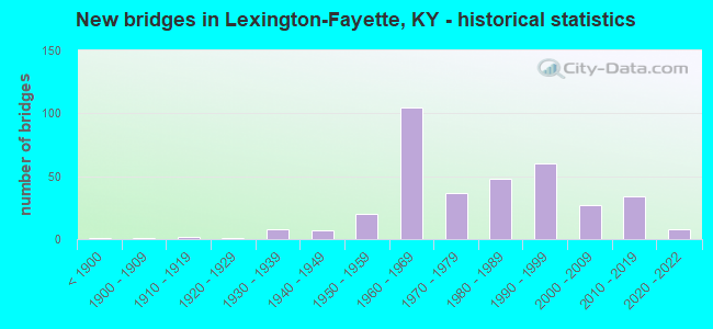
- New bridges - historical statistics
- 1Before 1900
- 11900-1909
- 21910-1919
- 11920-1929
- 81930-1939
- 71940-1949
- 201950-1959
- 1051960-1969
- 371970-1979
- 481980-1989
- 601990-1999
- 272000-2009
- 342010-2019
- 82020-2022
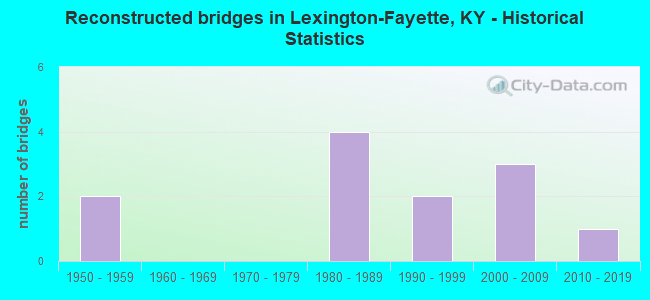
- Reconstructed bridges - Historical Statistics
- 21950-1959
- 01960-1969
- 01970-1979
- 41980-1989
- 21990-1999
- 32000-2009
- 12010-2019
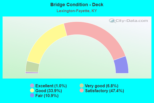
- Bridge Condition - Deck
- 1.0%Excellent
- 6.8%Very good
- 33.9%Good
- 47.4%Satisfactory
- 10.9%Fair
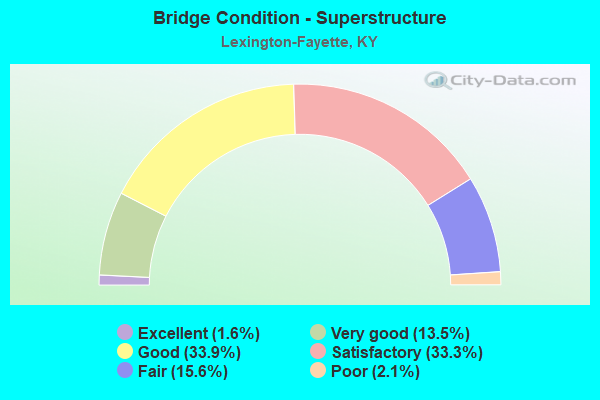
- Bridge Condition - Superstructure
- 1.6%Excellent
- 13.5%Very good
- 33.9%Good
- 33.3%Satisfactory
- 15.6%Fair
- 2.1%Poor
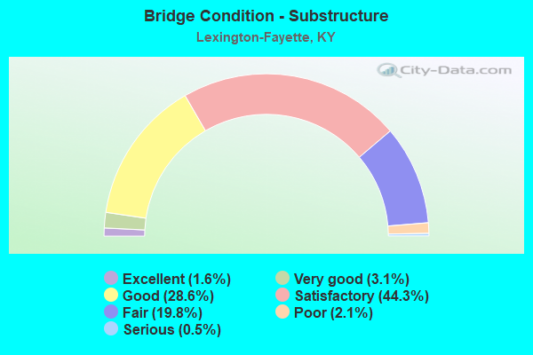
- Bridge Condition - Substructure
- 1.6%Excellent
- 3.1%Very good
- 28.6%Good
- 44.3%Satisfactory
- 19.8%Fair
- 2.1%Poor
- 0.5%Serious
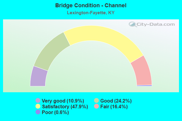
- Bridge Condition - Channel
- 10.9%Very good
- 24.2%Good
- 47.9%Satisfactory
- 16.4%Fair
- 0.6%Poor
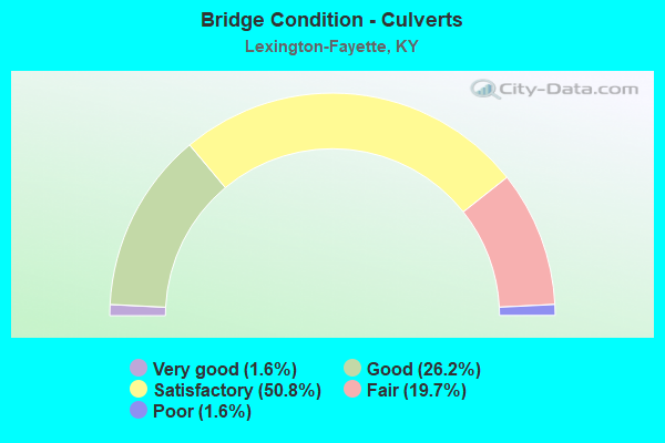
- Bridge Condition - Culverts
- 1.6%Very good
- 26.2%Good
- 50.8%Satisfactory
- 19.7%Fair
- 1.6%Poor
Find on map >> Show street view
Structure Number: 34C00080N, Location: E. OF SUMMERVILLE DR (Lat: 38.044167, Lng: -84.535000), Route carried "on" structure: City street 4669, Year Built: 2010, Status: Open, Structure Length: 0.85m (2.79ft), Average Daily Traffic: 1,746 (year 2012), Average Future Daily Traffic: 2,032 (year 2032), Features Intersected: VAUGHNS BRANCH, Facility Carried by Structure: PINE MEADOWS RD
Minimum Vertical Clearance: 30+ m (98+ ft), Kilometerpoint: 0.515, Lanes on structure: 2, Owner: County Highway Agency, Approaching Roadway Width: 8.2m (26.9ft), Skew: 4 degrees, Material/Design: Concrete, Design/Construction: Culvert, Number Of Spans In Main Unit: 1, Length of Maximum Span: 8.5m (27.9ft), Curb or Sidewalk Widths: Left: 1.2m (3.9ft), Right: 1.2m (3.9ft), Curb-To-Curb Width: 9.8m (32.2ft), Out-to-Out Width: 12.8m (42.0ft)
Condition: Channel: Good, Culverts: Good, Operating Rating: 54.4 metric tons, Method Used To Determine Operating Rating: Field evaluation and documented engineering judgment, Inventory Rating: 39.9 metric tons, Method Used To Determine Inventory Rating: Field evaluation and documented engineering judgment, Structural Evaluation: Better than present minimum criteria, Deck Geometry: Somewhat better than minimum adequacy, Waterway Adequacy: Equal to present desirable criteria, Approach Roadway Alignment: Equal to present desirable criteria, Designated Inspection Frequency: Every 24 months, Inspection Date: April 2021
Find on map >> Show street view
Structure Number: 34C00081N, Location: E. OF BEACON HILL RD. (Lat: 38.042500, Lng: -84.533056), Route carried "on" structure: City street 4833, Year Built: 2010, Status: Open, Structure Length: 1.04m (3.41ft), Average Daily Traffic: 1,185 (year 2012), Average Future Daily Traffic: 2,032 (year 2032), Features Intersected: VAUGHNS BRANCH, Facility Carried by Structure: SUMMERVILLE ROAD
Minimum Vertical Clearance: 30+ m (98+ ft), Kilometerpoint: 0.446, Lanes on structure: 2, Owner: County Highway Agency, Approaching Roadway Width: 10.1m (33.1ft), Skew: 4 degrees, Material/Design: Concrete, Design/Construction: Culvert, Number Of Spans In Main Unit: 1, Length of Maximum Span: 10.4m (34.1ft), Curb or Sidewalk Widths: Left: 1.2m (3.9ft), Right: 1.2m (3.9ft), Curb-To-Curb Width: 10.1m (33.1ft), Out-to-Out Width: 13.1m (43.0ft)
Condition: Channel: Good, Culverts: Good, Operating Rating: 54.4 metric tons, Method Used To Determine Operating Rating: Field evaluation and documented engineering judgment, Inventory Rating: 39.9 metric tons, Method Used To Determine Inventory Rating: Field evaluation and documented engineering judgment, Structural Evaluation: Better than present minimum criteria, Deck Geometry: Somewhat better than minimum adequacy, Waterway Adequacy: Equal to present desirable criteria, Approach Roadway Alignment: Equal to present desirable criteria, Designated Inspection Frequency: Every 24 months, Inspection Date: April 2021
Find on map >> Show street view
Structure Number: 34C00082L, Location: .6 MI E US 421 (Lat: 38.087778, Lng: -84.539722), Route carried "on" structure: State highway 1878, Year Built: 2016, Status: Open, Structure Length: 3.14m (10.30ft), Average Daily Traffic: 7,089 (year 2019), Truck Traffic: 5%, Average Future Daily Traffic: 7,089 (year 2039), Design Load: HS 25 or greater, Features Intersected: BRACKTOWN BRANCH, Facility Carried by Structure: CITATION BLVD
Minimum Vertical Clearance: 30+ m (98+ ft), Kilometerpoint: 5.077, Lanes on structure: 2, Owner: State Highway Agency, Approaching Roadway Width: 9.8m (32.2ft), Skew: 1 degrees, Material/Design: Prestressed concrete continuous, Design/Construction: Stringer/Multi-beam, Number Of Spans In Main Unit: 1, Length of Maximum Span: 29.7m (97.4ft), Curb or Sidewalk Widths: Left: 2.6m (8.5ft), Right: 0.0m, Curb-To-Curb Width: 11.0m (36.1ft), Out-to-Out Width: 14.6m (47.9ft)
Condition: Deck: Very good, Superstructure: Very good, Substructure: Good, Channel: Very good, Operating Rating: 99.8 metric tons, Method Used To Determine Operating Rating: Load Factor (LF), Inventory Rating: 66.0 metric tons, Method Used To Determine Inventory Rating: Load Factor (LF), Structural Evaluation: Better than present minimum criteria, Deck Geometry: Equal to present minimum criteria, Waterway Adequacy: Superior to present desirable criteria, Approach Roadway Alignment: Equal to present desirable criteria, Designated Inspection Frequency: Every 24 months, Inspection Date: May 2021, Deck Structure Type: Concrete Cast-file-Place, Wearing Surface/Protective System: Wearing Surface: Monolithic Concrete, Deck Protection: Epoxy Coated Reinforcing
Find on map >> Show street view
Structure Number: 34C00082R, Location: .6 MI E US 421 (Lat: 38.087778, Lng: -84.540000), Route carried "on" structure: State highway 1878, Year Built: 2016, Status: Open, Structure Length: 3.14m (10.30ft), Average Daily Traffic: 7,089 (year 2019), Truck Traffic: 5%, Average Future Daily Traffic: 7,089 (year 2039), Design Load: HS 25 or greater, Features Intersected: BRACKTOWN BRANCH, Facility Carried by Structure: CITATION BLVD
Minimum Vertical Clearance: 30+ m (98+ ft), Kilometerpoint: 5.077, Lanes on structure: 2, Owner: State Highway Agency, Approaching Roadway Width: 9.8m (32.2ft), Skew: 12 degrees, Material/Design: Prestressed concrete continuous, Design/Construction: Stringer/Multi-beam, Number Of Spans In Main Unit: 1, Length of Maximum Span: 29.6m (97.1ft), Curb or Sidewalk Widths: Left: 0.0m, Right: 2.1m (6.9ft), Curb-To-Curb Width: 11.0m (36.1ft), Out-to-Out Width: 14.6m (47.9ft)
Condition: Deck: Very good, Superstructure: Very good, Substructure: Good, Channel: Very good, Operating Rating: 99.8 metric tons, Method Used To Determine Operating Rating: Load Factor (LF), Inventory Rating: 66.0 metric tons, Method Used To Determine Inventory Rating: Load Factor (LF), Structural Evaluation: Better than present minimum criteria, Deck Geometry: Equal to present minimum criteria, Waterway Adequacy: Superior to present desirable criteria, Approach Roadway Alignment: Equal to present desirable criteria, Designated Inspection Frequency: Every 24 months, Inspection Date: May 2021, Deck Structure Type: Concrete Cast-file-Place, Wearing Surface/Protective System: Wearing Surface: Monolithic Concrete, Deck Protection: Epoxy Coated Reinforcing
Find on map >> Show street view
Structure Number: 34C00083L, Location: 0.28 MI E OF KY 1978 (Lat: 38.095278, Lng: -84.522500), Route carried "on" structure: State highway 1878, Year Built: 2016, Status: Open, Structure Length: 7.38m (24.21ft), Average Daily Traffic: 8,249 (year 2019), Truck Traffic: 5%, Average Future Daily Traffic: 8,249 (year 2039), Design Load: HS 25 or greater, Features Intersected: NORFOLK SOUTHERN RR, Facility Carried by Structure: CITATION BLVD
Minimum Vertical Clearance: 30+ m (98+ ft), Kilometerpoint: 3.262, Lanes on structure: 2, Owner: State Highway Agency, Approaching Roadway Width: 9.8m (32.2ft), Skew: 10 degrees, Material/Design: Prestressed concrete continuous, Design/Construction: Stringer/Multi-beam, Number Of Spans In Main Unit: 3, Length of Maximum Span: 28.9m (94.8ft), Curb or Sidewalk Widths: Left: 1.8m (5.9ft), Right: 0.0m, Curb-To-Curb Width: 11.0m (36.1ft), Out-to-Out Width: 14.0m (45.9ft)
Condition: Deck: Good, Superstructure: Very good, Substructure: Satisfactory, Operating Rating: 70.7 metric tons, Method Used To Determine Operating Rating: Load Factor (LF), Inventory Rating: 42.4 metric tons, Method Used To Determine Inventory Rating: Load Factor (LF), Structural Evaluation: Equal to present minimum criteria, Deck Geometry: Equal to present minimum criteria, Underclear: Superior to present desirable criteria, Approach Roadway Alignment: Equal to present desirable criteria, Designated Inspection Frequency: Every 24 months, Inspection Date: May 2021, Deck Structure Type: Concrete Cast-file-Place, Wearing Surface/Protective System: Wearing Surface: Monolithic Concrete, Deck Protection: Epoxy Coated Reinforcing
Find on map >> Show street view
Structure Number: 34C00083R, Location: 0.28 MI E OF KY 1978 (Lat: 38.095278, Lng: -84.522500), Route carried "on" structure: State highway 1878, Year Built: 2016, Status: Open, Structure Length: 7.38m (24.21ft), Average Daily Traffic: 8,249 (year 2019), Truck Traffic: 5%, Average Future Daily Traffic: 8,249 (year 2039), Design Load: HS 25 or greater, Features Intersected: NORFOLK SOUTHERN RR, Facility Carried by Structure: CITATION BLVD
Minimum Vertical Clearance: 30+ m (98+ ft), Kilometerpoint: 3.262, Lanes on structure: 2, Owner: State Highway Agency, Approaching Roadway Width: 9.8m (32.2ft), Skew: 10 degrees, Material/Design: Prestressed concrete continuous, Design/Construction: Stringer/Multi-beam, Number Of Spans In Main Unit: 3, Length of Maximum Span: 28.9m (94.8ft), Curb or Sidewalk Widths: Left: 0.0m, Right: 1.8m (5.9ft), Curb-To-Curb Width: 11.0m (36.1ft), Out-to-Out Width: 14.0m (45.9ft)
Condition: Deck: Good, Superstructure: Excellent, Substructure: Satisfactory, Operating Rating: 70.7 metric tons, Method Used To Determine Operating Rating: Load Factor (LF), Inventory Rating: 42.4 metric tons, Method Used To Determine Inventory Rating: Load Factor (LF), Structural Evaluation: Equal to present minimum criteria, Deck Geometry: Equal to present minimum criteria, Underclear: Superior to present desirable criteria, Approach Roadway Alignment: Equal to present desirable criteria, Designated Inspection Frequency: Every 24 months, Inspection Date: May 2021, Deck Structure Type: Concrete Cast-file-Place, Wearing Surface/Protective System: Wearing Surface: Monolithic Concrete, Deck Protection: Epoxy Coated Reinforcing
Find on map >> Show street view
Structure Number: 34C00084N, Location: .2 MI E JCT US 421 (Lat: 38.089722, Lng: -84.546389), Route carried "on" structure: City street 1233, Year Built: 2000, Status: Open, Structure Length: 1.06m (3.48ft), Average Daily Traffic: 4,269 (year 2017), Average Future Daily Traffic: 4,269 (year 2037), Features Intersected: FORK OF TOWN BRANCH, Facility Carried by Structure: LUCILLE DRIVE
Minimum Vertical Clearance: 30+ m (98+ ft), Kilometerpoint: 2.253, Lanes on structure: 1, Owner: County Highway Agency, Approaching Roadway Width: 12.1m (39.7ft), Material/Design: Concrete, Design/Construction: Culvert, Number Of Spans In Main Unit: 3, Length of Maximum Span: 3.4m (11.2ft)
Condition: Channel: Good, Culverts: Good, Operating Rating: 54.4 metric tons, Method Used To Determine Operating Rating: Field evaluation and documented engineering judgment, Inventory Rating: 39.9 metric tons, Method Used To Determine Inventory Rating: Field evaluation and documented engineering judgment, Structural Evaluation: Better than present minimum criteria, Waterway Adequacy: Equal to present minimum criteria, Approach Roadway Alignment: Better than present minimum criteria, Designated Inspection Frequency: Every 24 months, Inspection Date: April 2021
Find on map >> Show street view
Structure Number: 34C00085N, Location: W@JCT-TATES CR RD-KY1974 (Lat: 37.993056, Lng: -84.495278), Route carried "on" structure: City street 3605, Year Built: 2019, Status: Open, Structure Length: 0.87m (2.85ft), Average Daily Traffic: 3,972 (year 2020), Truck Traffic: 5%, Average Future Daily Traffic: 3,693 (year 2040), Design Load: Greater than HL93, Features Intersected: Branch - Hickman Creek, Facility Carried by Structure: Malabu Drive
Minimum Vertical Clearance: 30+ m (98+ ft), Kilometerpoint: 2.697, Lanes on structure: 2, Owner: County Highway Agency, Approaching Roadway Width: 12.2m (40.0ft), Material/Design: Prestressed concrete, Design/Construction: Box Beam or Girders - Multiple, Number Of Spans In Main Unit: 1, Length of Maximum Span: 7.9m (25.9ft), Curb or Sidewalk Widths: Left: 1.5m (4.9ft), Right: 1.5m (4.9ft), Curb-To-Curb Width: 12.2m (40.0ft), Out-to-Out Width: 15.8m (51.8ft)
Condition: Deck: Excellent, Superstructure: Excellent, Substructure: Good, Channel: Good, Operating Rating: 97.2 metric tons, Method Used To Determine Operating Rating: Load and Resistance Factor Rating (LRFR) rating reported by rating factor(RF) method using HL-93 loadings, Inventory Rating: 87.5 metric tons, Method Used To Determine Inventory Rating: Load and Resistance Factor Rating (LRFR) rating reported by rating factor(RF) method using HL-93 loadings, Structural Evaluation: Better than present minimum criteria, Deck Geometry: Equal to present minimum criteria, Waterway Adequacy: Better than present minimum criteria, Approach Roadway Alignment: Meets minimum limits, Designated Inspection Frequency: Every 24 months, Inspection Date: April 2021, Deck Structure Type: Concrete Cast-file-Place, Wearing Surface/Protective System: Wearing Surface: Monolithic Concrete, Deck Protection: Epoxy Coated Reinforcing
Find on map >> Show street view
Structure Number: 34C00086N, Location: .1 MI W OF JCT KY 1974 (Lat: 37.974167, Lng: -84.499444), Route carried "on" structure: City street 7038, Year Built: 2019, Status: Open, Structure Length: 1.20m (3.94ft), Average Daily Traffic: 9,297 (year 2020), Average Future Daily Traffic: 8,646 (year 2040), Design Load: HS 25 or greater, Features Intersected: West Hickman creek, Facility Carried by Structure: Wilson Downing Rd
Minimum Vertical Clearance: 30+ m (98+ ft), Kilometerpoint: 2.689, Lanes on structure: 2, Owner: County Highway Agency, Approaching Roadway Width: 11.6m (38.1ft), Material/Design: Prestressed concrete, Design/Construction: Box Beam or Girders - Multiple, Number Of Spans In Main Unit: 1, Length of Maximum Span: 11.1m (36.4ft), Curb or Sidewalk Widths: Left: 1.5m (4.9ft), Right: 1.5m (4.9ft), Curb-To-Curb Width: 11.6m (38.1ft), Out-to-Out Width: 15.6m (51.2ft)
Condition: Deck: Very good, Superstructure: Very good, Substructure: Good, Channel: Good, Operating Rating: 79.1 metric tons, Method Used To Determine Operating Rating: Load and Resistance Factor Rating (LRFR) rating reported by rating factor(RF) method using HL-93 loadings, Inventory Rating: 60.9 metric tons, Method Used To Determine Inventory Rating: Load and Resistance Factor Rating (LRFR) rating reported by rating factor(RF) method using HL-93 loadings, Structural Evaluation: Better than present minimum criteria, Deck Geometry: Somewhat better than minimum adequacy, Waterway Adequacy: Equal to present desirable criteria, Approach Roadway Alignment: Equal to present desirable criteria, Designated Inspection Frequency: Every 24 months, Inspection Date: April 2021, Deck Structure Type: Concrete Precast Panels, Wearing Surface/Protective System: Wearing Surface: Bituminous
Find on map >> Show street view
Structure Number: 34C00087N, Location: 05 MI WEST OF JCT KY 1974 (Lat: 37.977500, Lng: -84.505833), Route carried "on" structure: City street 7038, Year Built: 2019, Status: Open, Structure Length: 0.96m (3.15ft), Average Daily Traffic: 9,297 (year 2020), Average Future Daily Traffic: 8,646 (year 2040), Design Load: Greater than HL93, Features Intersected: WEST HICKMAN TRIB, Facility Carried by Structure: WILSON DOWNING RD
Minimum Vertical Clearance: 30+ m (98+ ft), Kilometerpoint: 2.042, Lanes on structure: 2, Owner: County Highway Agency, Approaching Roadway Width: 10.7m (35.1ft), Material/Design: Concrete, Design/Construction: Culvert, Number Of Spans In Main Unit: 1, Length of Maximum Span: 7.5m (24.6ft), Curb-To-Curb Width: 10.7m (35.1ft), Out-to-Out Width: 11.3m (37.1ft)
Condition: Channel: Very good, Culverts: Very good, Operating Rating: 54.4 metric tons, Method Used To Determine Operating Rating: Field evaluation and documented engineering judgment, Inventory Rating: 40.8 metric tons, Method Used To Determine Inventory Rating: Field evaluation and documented engineering judgment, Structural Evaluation: Equal to present desirable criteria, Deck Geometry: Meets minimum limits, Waterway Adequacy: Equal to present desirable criteria, Approach Roadway Alignment: Superior to present desirable criteria, Designated Inspection Frequency: Every 24 months, Inspection Date: April 2021
Find on map >> Show street view
Structure Number: 34C00088N, Location: .2MI W OF KY 922 (Lat: 38.073889, Lng: -84.490833), Route carried "on" structure: Other road 2021, Year Built: 2020, Status: Open, Structure Length: 5.08m (16.67ft), Average Daily Traffic: 300 (year 2020), Average Future Daily Traffic: 366 (year 2040), Design Load: Greater than HL93, Features Intersected: KY 4 NEW CIRCLE RD, Facility Carried by Structure: LEXMARK ACCES RD
Minimum Vertical Clearance: 30+ m (98+ ft), Kilometerpoint: 0.158, Lanes on structure: 2, Lanes under structure: 4, Owner: Private, Approaching Roadway Width: 13.4m (44.0ft), Material/Design: Prestressed concrete, Design/Construction: Stringer/Multi-beam, Number Of Spans In Main Unit: 1, Length of Maximum Span: 24.9m (81.7ft), Curb-To-Curb Width: 12.5m (41.0ft), Out-to-Out Width: 13.4m (44.0ft)
Condition: Deck: Very good, Superstructure: Satisfactory, Substructure: Very good, Operating Rating: 60.9 metric tons, Method Used To Determine Operating Rating: Load and Resistance Factor Rating (LRFR) rating reported by rating factor(RF) method using HL-93 loadings, Inventory Rating: 47.0 metric tons, Method Used To Determine Inventory Rating: Load and Resistance Factor Rating (LRFR) rating reported by rating factor(RF) method using HL-93 loadings, Structural Evaluation: Equal to present minimum criteria, Deck Geometry: Superior to present desirable criteria, Underclear: High priority of corrective action, Approach Roadway Alignment: Equal to present desirable criteria, Designated Inspection Frequency: Every 24 months, Inspection Date: April 2021, Deck Structure Type: Concrete Cast-file-Place, Wearing Surface/Protective System: Wearing Surface: Monolithic Concrete, Deck Protection: Epoxy Coated Reinforcing
Find on map >> Show street view
Structure Number: 34C00089N, Location: .8 MI N OF JCT US 60 (Lat: 38.050556, Lng: -84.420833), Route carried "on" structure: County highway 1001, Year Built: 2021, Status: Open, Structure Length: 1.95m (6.40ft), Average Daily Traffic: 2,578 (year 2011), Average Future Daily Traffic: 2,242 (year 2031), Design Load: Greater than HL93, Features Intersected: David Fork-N. Elkhorn, Facility Carried by Structure: Hume Road
Minimum Vertical Clearance: 30+ m (98+ ft), Kilometerpoint: 2.612, Lanes on structure: 2, Owner: County Highway Agency, Approaching Roadway Width: 6.1m (20.0ft), Material/Design: Prestressed concrete, Design/Construction: Box Beam or Girders - Multiple, Number Of Spans In Main Unit: 1, Length of Maximum Span: 19.1m (62.7ft), Curb-To-Curb Width: 8.3m (27.2ft), Out-to-Out Width: 8.5m (27.9ft)
Condition: Deck: Very good, Superstructure: Very good, Substructure: Very good, Channel: Very good, Operating Rating: 60.6 metric tons, Method Used To Determine Operating Rating: Load and Resistance Factor Rating (LRFR) rating reported by rating factor(RF) method using HL-93 loadings, Inventory Rating: 46.7 metric tons, Method Used To Determine Inventory Rating: Load and Resistance Factor Rating (LRFR) rating reported by rating factor(RF) method using HL-93 loadings, Structural Evaluation: Equal to present desirable criteria, Deck Geometry: High priority of corrective action, Waterway Adequacy: Equal to present desirable criteria, Approach Roadway Alignment: Equal to present desirable criteria, Designated Inspection Frequency: Every 24 months, Inspection Date: April 2021, Deck Structure Type: Concrete Cast-file-Place, Wearing Surface/Protective System: Wearing Surface: Monolithic Concrete, Deck Protection: Epoxy Coated Reinforcing
Find on map >> Show street view
Structure Number: 34C00090N, Location: .6 MI WEST OF KY 1974 (Lat: 37.959722, Lng: -84.503611), Route carried "on" structure: City street 3198, Year Built: 1993, Status: Open, Structure Length: 3.19m (10.47ft), Average Daily Traffic: 8,490 (year 2017), Average Future Daily Traffic: 7,895 (year 2037), Design Load: HS 20, Features Intersected: WEST HICKMAN CREEK, Facility Carried by Structure: CLEARWATER WAY
Minimum Vertical Clearance: 30+ m (98+ ft), Kilometerpoint: 0.898, Lanes on structure: 2, Owner: County Highway Agency, Approaching Roadway Width: 8.4m (27.6ft), Skew: 4 degrees, Material/Design: Concrete, Design/Construction: Culvert, Number Of Spans In Main Unit: 3, Length of Maximum Span: 10.7m (35.1ft), Curb-To-Curb Width: 8.4m (27.6ft), Out-to-Out Width: 8.4m (27.6ft)
Condition: Channel: Good, Culverts: Good, Operating Rating: 99.8 metric tons, Method Used To Determine Operating Rating: Load Factor (LF), Inventory Rating: 99.8 metric tons, Method Used To Determine Inventory Rating: Load Factor (LF), Structural Evaluation: Better than present minimum criteria, Deck Geometry: High priority of replacement, Waterway Adequacy: Better than present minimum criteria, Approach Roadway Alignment: Somewhat better than minimum adequacy, Designated Inspection Frequency: Every 24 months, Inspection Date: July 2021
Find on map >> Show street view
Structure Number: 57B00010N, Location: .8 MI N OF JCT KY 1974 (Lat: 37.874167, Lng: -84.454444), Route carried "on" structure: State highway 169, Year Built: 1950, Status: Posted for load, Structure Length: 1.02m (3.35ft), Average Daily Traffic: 1,413 (year 2019), Truck Traffic: 5%, Average Future Daily Traffic: 1,243 (year 2039), Design Load: HS 20, Features Intersected: MARBLE CREEK
Minimum Vertical Clearance: 30+ m (98+ ft), Kilometerpoint: 4.743, Lanes on structure: 2, Owner: State Highway Agency, Approaching Roadway Width: 7.8m (25.6ft), Skew: 3 degrees, Material/Design: Concrete, Design/Construction: Culvert, Number Of Spans In Main Unit: 2, Length of Maximum Span: 4.7m (15.4ft)
Condition: Channel: Satisfactory, Culverts: Satisfactory, Operating Rating: 28.2 metric tons, Method Used To Determine Operating Rating: Field evaluation and documented engineering judgment, Inventory Rating: 18.1 metric tons, Method Used To Determine Inventory Rating: Field evaluation and documented engineering judgment, Structural Evaluation: Somewhat better than minimum adequacy, Waterway Adequacy: Equal to present desirable criteria, Approach Roadway Alignment: Somewhat better than minimum adequacy, Bridge Posting: Required (Relationship of Operating Rating to Maximum Legal Load: > 39.9% below), Designated Inspection Frequency: Every 24 months, Inspection Date: January 2021
Find on map >> Show street view
Structure Number: 57B00019N, Location: 2.5 MI EAST OF JCT US 27 (Lat: 37.934444, Lng: -84.502222), Route carried "on" structure: State highway 1980, Year Built: 1974, Status: Open, Structure Length: 3.23m (10.60ft), Average Daily Traffic: 1,734 (year 2020), Truck Traffic: 5%, Average Future Daily Traffic: 1,612 (year 2040), Design Load: HS 20, Features Intersected: WEST HICKMAN CREEK
Minimum Vertical Clearance: 30+ m (98+ ft), Kilometerpoint: 9.160, Lanes on structure: 2, Owner: State Highway Agency, Approaching Roadway Width: 7.2m (23.6ft), Skew: 3 degrees, Material/Design: Prestressed concrete, Design/Construction: Box Beam or Girders - Multiple, Number Of Spans In Main Unit: 2, Length of Maximum Span: 15.2m (49.9ft), Curb-To-Curb Width: 8.8m (28.9ft), Out-to-Out Width: 9.3m (30.5ft)
Condition: Deck: Good, Superstructure: Satisfactory, Substructure: Satisfactory, Channel: Good, Operating Rating: 55.2 metric tons, Method Used To Determine Operating Rating: Load Factor (LF), Inventory Rating: 33.1 metric tons, Method Used To Determine Inventory Rating: Load Factor (LF), Structural Evaluation: Equal to present minimum criteria, Deck Geometry: Somewhat better than minimum adequacy, Waterway Adequacy: Equal to present desirable criteria, Approach Roadway Alignment: Better than present minimum criteria, Designated Inspection Frequency: Every 24 months, Inspection Date: January 2021, Deck Structure Type: Concrete Precast Panels, Wearing Surface/Protective System: Wearing Surface: Bituminous, Membrane: Preformed Fabric
Find on map >> Show street view
Structure Number: 57C00038N, Location: .3 MI N JCT KY 1980 (Lat: 37.973056, Lng: -84.573056), Route carried "on" structure: County highway 1016, Year Built: 1991, Status: Open, Structure Length: 1.40m (4.59ft), Average Daily Traffic: 6,341 (year 2019), Average Future Daily Traffic: 5,897 (year 2039), Design Load: HS 25 or greater, Features Intersected: BR-SOUTH ELKHORN, Facility Carried by Structure: CLAYS MILL ROAD
Minimum Vertical Clearance: 30+ m (98+ ft), Kilometerpoint: 0.579, Lanes on structure: 2, Owner: County Highway Agency, Approaching Roadway Width: 7.3m (24.0ft), Material/Design: Prestressed concrete, Design/Construction: Box Beam or Girders - Multiple, Number Of Spans In Main Unit: 1, Length of Maximum Span: 12.8m (42.0ft), Curb-To-Curb Width: 9.4m (30.8ft), Out-to-Out Width: 9.9m (32.5ft)
Condition: Deck: Satisfactory, Superstructure: Very good, Substructure: Satisfactory, Channel: Satisfactory, Operating Rating: 66.1 metric tons, Method Used To Determine Operating Rating: Load Factor (LF), Inventory Rating: 39.6 metric tons, Method Used To Determine Inventory Rating: Load Factor (LF), Structural Evaluation: Equal to present minimum criteria, Deck Geometry: High priority of corrective action, Waterway Adequacy: Equal to present desirable criteria, Approach Roadway Alignment: Equal to present desirable criteria, Designated Inspection Frequency: Every 24 months, Inspection Date: January 2021, Deck Structure Type: Concrete Cast-file-Place, Wearing Surface/Protective System: Wearing Surface: Monolithic Concrete, Deck Protection: Epoxy Coated Reinforcing
Find on map >> Show street view
Structure Number: 57C00044N, Location: .1 MI N JCT KY 1980 (Lat: 37.969167, Lng: -84.568889), Route carried "on" structure: County highway 1017, Year Built: 1994, Status: Posted for load, Structure Length: 0.79m (2.59ft), Average Daily Traffic: 203 (year 2006), Average Future Daily Traffic: 208 (year 2026), Design Load: HS 25 or greater, Features Intersected: BRANCH-SOUTH ELKHORN, Facility Carried by Structure: BRANWOOD DRIVE
Minimum Vertical Clearance: 30+ m (98+ ft), Kilometerpoint: 0.257, Lanes on structure: 2, Owner: County Highway Agency, Approaching Roadway Width: 10.1m (33.1ft), Material/Design: Prestressed concrete, Design/Construction: Box Beam or Girders - Multiple, Number Of Spans In Main Unit: 1, Length of Maximum Span: 7.6m (24.9ft), Curb-To-Curb Width: 10.6m (34.8ft), Out-to-Out Width: 11.1m (36.4ft)
Condition: Deck: Good, Superstructure: Good, Substructure: Good, Channel: Good, Operating Rating: 59.7 metric tons, Method Used To Determine Operating Rating: Load Factor (LF), Inventory Rating: 35.8 metric tons, Method Used To Determine Inventory Rating: Load Factor (LF), Structural Evaluation: Better than present minimum criteria, Deck Geometry: Better than present minimum criteria, Waterway Adequacy: Equal to present desirable criteria, Approach Roadway Alignment: Equal to present desirable criteria, Bridge Posting: Required (Relationship of Operating Rating to Maximum Legal Load: 10.0 - 19.9% below), Designated Inspection Frequency: Every 24 months, Inspection Date: January 2021, Deck Structure Type: Concrete Precast Panels, Wearing Surface/Protective System: Wearing Surface: Monolithic Concrete
Find on map >> Show street view
Structure Number: 57C00047N, Location: 1.0 MI N. JCT KY 169 (Lat: 37.905833, Lng: -84.499167), Route carried "on" structure: County highway 1010, Year Built: 1997, Status: Posted for load, Structure Length: 3.51m (11.52ft), Average Daily Traffic: 133 (year 2009), Average Future Daily Traffic: 115 (year 2029), Design Load: HS 25 or greater, Features Intersected: EAST HICKMAN CREEK, Facility Carried by Structure: MACKEY PIKE
Minimum Vertical Clearance: 30+ m (98+ ft), Kilometerpoint: 3.322, Lanes on structure: 2, Owner: County Highway Agency, Approaching Roadway Width: 7.0m (23.0ft), Skew: 3 degrees, Material/Design: Prestressed concrete, Design/Construction: Box Beam or Girders - Multiple, Number Of Spans In Main Unit: 3, Length of Maximum Span: 19.8m (65.0ft), Curb-To-Curb Width: 6.8m (22.3ft), Out-to-Out Width: 7.3m (24.0ft)
Condition: Deck: Good, Superstructure: Fair, Substructure: Good, Channel: Satisfactory, Operating Rating: 61.7 metric tons, Method Used To Determine Operating Rating: Load Factor (LF), Inventory Rating: 37.0 metric tons, Method Used To Determine Inventory Rating: Load Factor (LF), Structural Evaluation: Somewhat better than minimum adequacy, Deck Geometry: Meets minimum limits, Waterway Adequacy: Equal to present minimum criteria, Approach Roadway Alignment: Equal to present minimum criteria, Bridge Posting: Required (Relationship of Operating Rating to Maximum Legal Load: 0.1 - 9.9% below), Designated Inspection Frequency: Every 24 months, Inspection Date: January 2021, Deck Structure Type: Concrete Precast Panels, Wearing Surface/Protective System: Wearing Surface: Monolithic Concrete
Find on map >> Show street view
Structure Number: 76B00030N, Location: .75 MI S OF JCT KY 1156 (Lat: 37.832222, Lng: -84.419444), Route carried "on" structure: State highway 169, Year Built: 1954, Status: Open, Structure Length: 3.47m (11.38ft), Average Daily Traffic: 346 (year 2020), Truck Traffic: 4%, Average Future Daily Traffic: 304 (year 2040), Design Load: H 20, Features Intersected: TATES CREEK
Minimum Vertical Clearance: 30+ m (98+ ft), Kilometerpoint: 17.719, Lanes on structure: 2, Owner: State Highway Agency, Approaching Roadway Width: 6.1m (20.0ft), Material/Design: Concrete, Design/Construction: Tee Beam, Number Of Spans In Main Unit: 3, Length of Maximum Span: 10.5m (34.4ft), Curb or Sidewalk Widths: Left: 0.4m (1.3ft), Right: 0.4m (1.3ft), Curb-To-Curb Width: 8.6m (28.2ft), Out-to-Out Width: 9.8m (32.2ft)
Condition: Deck: Satisfactory, Superstructure: Poor, Substructure: Fair, Channel: Fair, Operating Rating: 57.8 metric tons, Method Used To Determine Operating Rating: Load Factor (LF), Inventory Rating: 34.6 metric tons, Method Used To Determine Inventory Rating: Load Factor (LF), Structural Evaluation: Meets minimum limits, Deck Geometry: Equal to present minimum criteria, Waterway Adequacy: Equal to present desirable criteria, Approach Roadway Alignment: Somewhat better than minimum adequacy, Designated Inspection Frequency: Every 24 months, Inspection Date: April 2020, Deck Structure Type: Concrete Cast-file-Place, Wearing Surface/Protective System: Wearing Surface: Latex Concrete
Find on map >> Show street view
Structure Number: 76B00039N, Location: @N-JCT I-75 & US 421 (Lat: 37.876389, Lng: -84.333056), Route carried "on" structure: US 25, Year Built: 1962, Status: Open, Structure Length: 8.11m (26.61ft), Average Daily Traffic: 2,934 (year 2019), Truck Traffic: 7%, Average Future Daily Traffic: 2,581 (year 2039), Design Load: HS 20, Features Intersected: I-75
Minimum Vertical Clearance: 30+ m (98+ ft), Kilometerpoint: 45.186, Lanes on structure: 2, Lanes under structure: 6, Owner: State Highway Agency, Approaching Roadway Width: 8.5m (27.9ft), Skew: 2 degrees, Material/Design: Concrete continuous, Design/Construction: Tee Beam, Number Of Spans In Main Unit: 4, Length of Maximum Span: 22.9m (75.1ft), Curb or Sidewalk Widths: Left: 0.8m (2.6ft), Right: 0.8m (2.6ft), Curb-To-Curb Width: 9.1m (29.9ft), Out-to-Out Width: 11.4m (37.4ft)
Condition: Deck: Fair, Superstructure: Satisfactory, Substructure: Fair, Operating Rating: 80.6 metric tons, Method Used To Determine Operating Rating: Load Factor (LF), Inventory Rating: 48.4 metric tons, Method Used To Determine Inventory Rating: Load Factor (LF), Structural Evaluation: Somewhat better than minimum adequacy, Deck Geometry: Meets minimum limits, Underclear: Meets minimum limits, Approach Roadway Alignment: Equal to present minimum criteria, Designated Inspection Frequency: Every 24 months, Inspection Date: April 2020, Deck Structure Type: Concrete Cast-file-Place, Wearing Surface/Protective System: Wearing Surface: Latex Concrete
Find on map >> Show street view
Structure Number: 76B00070N, Location: 50' W OF JCT KY 169 (Lat: 37.796389, Lng: -84.399167), Route carried "on" structure: State highway 1985, Year Built: 1968, Status: Open, Structure Length: 2.18m (7.15ft), Average Daily Traffic: 328 (year 2018), Average Future Daily Traffic: 285 (year 2038), Design Load: H 20, Features Intersected: TATES CREEK
Minimum Vertical Clearance: 30+ m (98+ ft), Kilometerpoint: 2.375, Lanes on structure: 2, Owner: State Highway Agency, Approaching Roadway Width: 5.8m (19.0ft), Skew: 2 degrees, Material/Design: Steel, Design/Construction: Stringer/Multi-beam, Number Of Spans In Main Unit: 1, Length of Maximum Span: 20.9m (68.6ft), Curb or Sidewalk Widths: Left: 0.3m (1.0ft), Right: 0.3m (1.0ft), Curb-To-Curb Width: 7.4m (24.3ft), Out-to-Out Width: 8.4m (27.6ft)
Condition: Deck: Good, Superstructure: Good, Substructure: Fair, Channel: Satisfactory, Operating Rating: 50.1 metric tons, Method Used To Determine Operating Rating: Load Factor (LF), Inventory Rating: 30.0 metric tons, Method Used To Determine Inventory Rating: Load Factor (LF), Structural Evaluation: Somewhat better than minimum adequacy, Deck Geometry: Somewhat better than minimum adequacy, Waterway Adequacy: Somewhat better than minimum adequacy, Approach Roadway Alignment: Equal to present minimum criteria, Designated Inspection Frequency: Every 24 months, Inspection Date: April 2020, Deck Structure Type: Concrete Cast-file-Place, Wearing Surface/Protective System: Wearing Surface: Latex Concrete
Find on map >> Show street view
Structure Number: 76B00079N, Location: .05 MI S OF JCT KY 169 (Lat: 37.843611, Lng: -84.424444), Route carried "on" structure: State highway 1156, Year Built: 1978, Status: Open, Structure Length: 6.31m (20.70ft), Average Daily Traffic: 229 (year 2018), Average Future Daily Traffic: 201 (year 2038), Design Load: H 20, Features Intersected: TATES CREEK
Minimum Vertical Clearance: 30+ m (98+ ft), Kilometerpoint: 14.938, Lanes on structure: 2, Owner: State Highway Agency, Approaching Roadway Width: 7.0m (23.0ft), Skew: 4 degrees, Material/Design: Prestressed concrete continuous, Design/Construction: Stringer/Multi-beam, Number Of Spans In Main Unit: 3, Length of Maximum Span: 18.1m (59.4ft), Curb-To-Curb Width: 7.3m (24.0ft), Out-to-Out Width: 8.6m (28.2ft)
Condition: Deck: Good, Superstructure: Good, Substructure: Satisfactory, Channel: Poor, Operating Rating: 77.3 metric tons, Method Used To Determine Operating Rating: Load Factor (LF), Inventory Rating: 46.4 metric tons, Method Used To Determine Inventory Rating: Load Factor (LF), Structural Evaluation: Equal to present minimum criteria, Deck Geometry: Somewhat better than minimum adequacy, Waterway Adequacy: Equal to present desirable criteria, Approach Roadway Alignment: Equal to present minimum criteria, Designated Inspection Frequency: Every 24 months, Inspection Date: April 2020, Deck Structure Type: Concrete Cast-file-Place, Wearing Surface/Protective System: Wearing Surface: Monolithic Concrete, Deck Protection: Epoxy Coated Reinforcing
Find on map >> Show street view
Structure Number: 76B00120N, Location: .6M S OF KY 1156 (Lat: 37.834167, Lng: -84.420833), Route carried "on" structure: State highway 169, Year Built: 2018, Status: Open, Structure Length: 1.58m (5.18ft), Average Daily Traffic: 346 (year 2020), Truck Traffic: 4%, Average Future Daily Traffic: 304 (year 2040), Design Load: Greater than HL93, Features Intersected: LONG BRANCH
Minimum Vertical Clearance: 30+ m (98+ ft), Kilometerpoint: 17.996, Lanes on structure: 2, Owner: State Highway Agency, Approaching Roadway Width: 5.9m (19.4ft), Skew: 3 degrees, Material/Design: Prestressed concrete, Design/Construction: Box Beam or Girders - Multiple, Number Of Spans In Main Unit: 1, Length of Maximum Span: 14.8m (48.6ft), Curb-To-Curb Width: 5.7m (18.7ft), Out-to-Out Width: 6.2m (20.3ft)
Condition: Deck: Very good, Superstructure: Very good, Substructure: Excellent, Channel: Very good, Operating Rating: 76.1 metric tons, Method Used To Determine Operating Rating: Load and Resistance Factor Rating (LRFR) rating reported by rating factor(RF) method using HL-93 loadings, Inventory Rating: 58.6 metric tons, Method Used To Determine Inventory Rating: Load and Resistance Factor Rating (LRFR) rating reported by rating factor(RF) method using HL-93 loadings, Structural Evaluation: Equal to present desirable criteria, Deck Geometry: High priority of corrective action, Waterway Adequacy: Better than present minimum criteria, Approach Roadway Alignment: Equal to present minimum criteria, Designated Inspection Frequency: Every 24 months, Inspection Date: April 2020, Deck Structure Type: Concrete Precast Panels, Wearing Surface/Protective System: Wearing Surface: Bituminous, Membrane: Preformed Fabric
Find on map >> Show street view
Structure Number: 76B00123N, Location: .1 Mi E of JCT US25&421 (Lat: 37.843611, Lng: -84.327222), Route carried "on" structure: State highway 627, Year Built: 2020, Status: Open, Structure Length: 7.53m (24.70ft), Average Daily Traffic: 6,426 (year 2021), Truck Traffic: 19%, Average Future Daily Traffic: 2,041 (year 2041), Design Load: Greater than HL93, Features Intersected: I75
Minimum Vertical Clearance: 30+ m (98+ ft), Kilometerpoint: 0.212, Lanes on structure: 4, Lanes under structure: 6, Base Highway Network: Yes, Owner: State Highway Agency, Approaching Roadway Width: 26.8m (87.9ft), Skew: 1 degrees, Material/Design: Prestressed concrete continuous, Design/Construction: Stringer/Multi-beam, Number Of Spans In Main Unit: 2, Length of Maximum Span: 37.3m (122.4ft), Curb-To-Curb Width: 27.7m (90.9ft), Out-to-Out Width: 27.7m (90.9ft)
Condition: Deck: Very good, Superstructure: Very good, Substructure: Very good, Operating Rating: 63.5 metric tons, Method Used To Determine Operating Rating: Load and Resistance Factor Rating (LRFR) rating reported by rating factor(RF) method using HL-93 loadings, Inventory Rating: 48.9 metric tons, Method Used To Determine Inventory Rating: Load and Resistance Factor Rating (LRFR) rating reported by rating factor(RF) method using HL-93 loadings, Structural Evaluation: Equal to present desirable criteria, Deck Geometry: Superior to present desirable criteria, Underclear: Somewhat better than minimum adequacy, Approach Roadway Alignment: Equal to present desirable criteria, Designated Inspection Frequency: Every 24 months, Inspection Date: September 2020, Deck Structure Type: Concrete Cast-file-Place, Wearing Surface/Protective System: Wearing Surface: Monolithic Concrete, Deck Protection: Epoxy Coated Reinforcing
Find on map >> Show street view
Structure Number: 76C00048N, Location: 1.1MI N-JCT I-75 (Lat: 37.887222, Lng: -84.314167), Route carried "on" structure: County highway 1319, Year Built: 1978, Status: Posted for load, Structure Length: 0.84m (2.76ft), Average Daily Traffic: 507 (year 2009), Average Future Daily Traffic: 441 (year 2029), Features Intersected: CALLOWAY CREEK, Facility Carried by Structure: SIMPSON LANE
Minimum Vertical Clearance: 30+ m (98+ ft), Kilometerpoint: 5.779, Lanes on structure: 2, Owner: County Highway Agency, Approaching Roadway Width: 6.1m (20.0ft), Skew: 4 degrees, Material/Design: Concrete, Design/Construction: Culvert, Number Of Spans In Main Unit: 3, Length of Maximum Span: 2.8m (9.2ft), Curb-To-Curb Width: 6.1m (20.0ft), Out-to-Out Width: 7.3m (24.0ft)
Condition: Channel: Satisfactory, Culverts: Satisfactory, Operating Rating: 16.3 metric tons, Method Used To Determine Operating Rating: Field evaluation and documented engineering judgment, Inventory Rating: 16.3 metric tons, Method Used To Determine Inventory Rating: Field evaluation and documented engineering judgment, Structural Evaluation: Meets minimum limits, Deck Geometry: High priority of corrective action, Waterway Adequacy: Equal to present minimum criteria, Approach Roadway Alignment: Meets minimum limits, Bridge Posting: Required (Relationship of Operating Rating to Maximum Legal Load: > 39.9% below), Length Of Structure Improvement: 0.09m (0.30ft), Designated Inspection Frequency: Every 24 months, Inspection Date: March 2020, Bridge Improvement Cost: $75,000, Total Project Cost: $75,000
Find on map >> Show street view
Structure Number: 76C00085N, Location: 1.0 MI N JCT I 75 (Lat: 37.884722, Lng: -84.317222), Route carried "on" structure: County highway 1319, Year Built: 1997, Status: Posted for load, Structure Length: 1.04m (3.41ft), Average Daily Traffic: 755 (year 2009), Average Future Daily Traffic: 656 (year 2029), Design Load: HS 25 or greater, Features Intersected: SMITH FORK, Facility Carried by Structure: SIMPSON LANE
Minimum Vertical Clearance: 30+ m (98+ ft), Kilometerpoint: 5.409, Lanes on structure: 2, Owner: County Highway Agency, Approaching Roadway Width: 4.9m (16.1ft), Skew: 1 degrees, Material/Design: Prestressed concrete, Design/Construction: Box Beam or Girders - Multiple, Number Of Spans In Main Unit: 1, Length of Maximum Span: 9.4m (30.8ft), Curb-To-Curb Width: 7.0m (23.0ft), Out-to-Out Width: 7.5m (24.6ft)
Condition: Deck: Good, Superstructure: Satisfactory, Substructure: Good, Channel: Fair, Operating Rating: 50.5 metric tons, Method Used To Determine Operating Rating: Load Factor (LF), Inventory Rating: 30.3 metric tons, Method Used To Determine Inventory Rating: Load Factor (LF), Structural Evaluation: Equal to present minimum criteria, Deck Geometry: Meets minimum limits, Waterway Adequacy: Somewhat better than minimum adequacy, Approach Roadway Alignment: Somewhat better than minimum adequacy, Bridge Posting: Required (Relationship of Operating Rating to Maximum Legal Load: 10.0 - 19.9% below), Designated Inspection Frequency: Every 24 months, Inspection Date: March 2020, Deck Structure Type: Concrete Precast Panels, Wearing Surface/Protective System: Wearing Surface: Monolithic Concrete, Deck Protection: Epoxy Coated Reinforcing
Find on map >> Show street view
Structure Number: 76C00089N, Location: .1 MI E JCT KY 169 (Lat: 37.849167, Lng: -84.430833), Route carried "on" structure: County highway 1327, Year Built: 1999, Status: Posted for load, Structure Length: 3.81m (12.50ft), Average Daily Traffic: 33 (year 2006), Average Future Daily Traffic: 42 (year 2026), Features Intersected: TATES CREEK, Facility Carried by Structure: TATTLERS BRANCH RO
Minimum Vertical Clearance: 30+ m (98+ ft), Kilometerpoint: 0.319, Lanes on structure: 2, Owner: County Highway Agency, Approaching Roadway Width: 3.7m (12.1ft), Material/Design: Steel, Design/Construction: Stringer/Multi-beam, Number Of Spans In Main Unit: 3, Length of Maximum Span: 21.3m (69.9ft), Curb-To-Curb Width: 6.0m (19.7ft), Out-to-Out Width: 6.1m (20.0ft)
Condition: Deck: Satisfactory, Superstructure: Satisfactory, Substructure: Good, Channel: Fair, Operating Rating: 34.7 metric tons, Method Used To Determine Operating Rating: Load Factor (LF), Inventory Rating: 20.9 metric tons, Method Used To Determine Inventory Rating: Load Factor (LF), Structural Evaluation: Equal to present minimum criteria, Deck Geometry: Meets minimum limits, Waterway Adequacy: Somewhat better than minimum adequacy, Approach Roadway Alignment: Equal to present minimum criteria, Bridge Posting: Required (Relationship of Operating Rating to Maximum Legal Load: 30.0 - 39.9% below), Designated Inspection Frequency: Every 24 months, Inspection Date: May 2020, Deck Structure Type: Corrugated Steel, Wearing Surface/Protective System: Wearing Surface: Bituminous
Find on map >> Show street view
Structure Number: 105B00052N, Location: .6 MI N OF JCT KY 1962 (Lat: 38.193333, Lng: -84.483611), Route carried "on" structure: State highway 922, Year Built: 1969, Status: Open, Structure Length: 2.62m (8.60ft), Average Daily Traffic: 1,797 (year 2018), Truck Traffic: 7%, Average Future Daily Traffic: 1,581 (year 2038), Design Load: H 20, Features Intersected: GOOSE CREEK
Minimum Vertical Clearance: 30+ m (98+ ft), Kilometerpoint: 2.081, Lanes on structure: 2, Owner: State Highway Agency, Approaching Roadway Width: 6.7m (22.0ft), Skew: 1 degrees, Material/Design: Concrete, Design/Construction: Tee Beam, Number Of Spans In Main Unit: 2, Length of Maximum Span: 12.2m (40.0ft), Curb or Sidewalk Widths: Left: 0.7m (2.3ft), Right: 0.7m (2.3ft), Curb-To-Curb Width: 7.8m (25.6ft), Out-to-Out Width: 9.2m (30.2ft)
Condition: Deck: Satisfactory, Superstructure: Good, Substructure: Satisfactory, Channel: Fair, Operating Rating: 75.4 metric tons, Method Used To Determine Operating Rating: Load Factor (LF), Inventory Rating: 45.3 metric tons, Method Used To Determine Inventory Rating: Load Factor (LF), Structural Evaluation: Equal to present minimum criteria, Deck Geometry: Meets minimum limits, Waterway Adequacy: Equal to present desirable criteria, Approach Roadway Alignment: Equal to present minimum criteria, Designated Inspection Frequency: Every 24 months, Inspection Date: March 2021, Deck Structure Type: Concrete Cast-file-Place, Wearing Surface/Protective System: Wearing Surface: Monolithic Concrete
Find on map >> Show street view
Structure Number: 105B00053N, Location: .50 MI SOU. OF JCT US 460 (Lat: 38.213056, Lng: -84.480833), Route carried "on" structure: State highway 922, Year Built: 1970, Status: Open, Structure Length: 1.31m (4.30ft), Average Daily Traffic: 1,797 (year 2018), Truck Traffic: 7%, Average Future Daily Traffic: 1,581 (year 2038), Design Load: H 20, Features Intersected: BOYD RUN CREEK
Minimum Vertical Clearance: 30+ m (98+ ft), Kilometerpoint: 4.311, Lanes on structure: 2, Owner: State Highway Agency, Approaching Roadway Width: 7.9m (25.9ft), Material/Design: Concrete, Design/Construction: Tee Beam, Number Of Spans In Main Unit: 1, Length of Maximum Span: 12.2m (40.0ft), Curb or Sidewalk Widths: Left: 0.2m (0.7ft), Right: 0.2m (0.7ft), Curb-To-Curb Width: 8.5m (27.9ft), Out-to-Out Width: 9.6m (31.5ft)
Condition: Deck: Satisfactory, Superstructure: Satisfactory, Substructure: Satisfactory, Channel: Good, Operating Rating: 68.0 metric tons, Method Used To Determine Operating Rating: Load Factor (LF), Inventory Rating: 40.8 metric tons, Method Used To Determine Inventory Rating: Load Factor (LF), Structural Evaluation: Equal to present minimum criteria, Deck Geometry: Somewhat better than minimum adequacy, Waterway Adequacy: Equal to present desirable criteria, Approach Roadway Alignment: Equal to present minimum criteria, Designated Inspection Frequency: Every 24 months, Inspection Date: March 2021, Deck Structure Type: Concrete Cast-file-Place, Wearing Surface/Protective System: Wearing Surface: Monolithic Concrete
Find on map >> Show street view
Structure Number: 105B00083N, Location: 1.2 MI S OF JCT KY 1973 (Lat: 38.157778, Lng: -84.612222), Route carried "on" structure: US 62, Year Built: 1973, Status: Open, Structure Length: 8.53m (27.99ft), Average Daily Traffic: 11,628 (year 2018), Truck Traffic: 11%, Average Future Daily Traffic: 10,232 (year 2038), Design Load: H 20, Features Intersected: I 64
Minimum Vertical Clearance: 30+ m (98+ ft), Kilometerpoint: 4.482, Lanes on structure: 2, Lanes under structure: 4, Owner: State Highway Agency, Approaching Roadway Width: 18.2m (59.7ft), Skew: 30 degrees, Material/Design: Concrete continuous, Design/Construction: Tee Beam, Number Of Spans In Main Unit: 4, Length of Maximum Span: 25.7m (84.3ft), Curb or Sidewalk Widths: Left: 0.2m (0.7ft), Right: 0.2m (0.7ft), Curb-To-Curb Width: 18.2m (59.7ft), Out-to-Out Width: 20.6m (67.6ft)
Condition: Deck: Fair, Superstructure: Good, Substructure: Satisfactory, Operating Rating: 67.1 metric tons, Method Used To Determine Operating Rating: Load Factor (LF), Inventory Rating: 40.3 metric tons, Method Used To Determine Inventory Rating: Load Factor (LF), Structural Evaluation: Equal to present minimum criteria, Deck Geometry: Superior to present desirable criteria, Underclear: Equal to present minimum criteria, Approach Roadway Alignment: Equal to present minimum criteria, Designated Inspection Frequency: Every 24 months, Inspection Date: March 2021, Deck Structure Type: Concrete Cast-file-Place, Wearing Surface/Protective System: Wearing Surface: Monolithic Concrete
Find on map >> Show street view
Structure Number: 105B00096N, Location: .35 MI E OF JCT KY 922 (Lat: 38.219722, Lng: -84.474722), Route carried "on" structure: US 460, Year Built: 1983, Status: Open, Structure Length: 0.91m (2.99ft), Average Daily Traffic: 4,400 (year 2020), Truck Traffic: 6%, Average Future Daily Traffic: 3,652 (year 2040), Design Load: HS 20, Features Intersected: CHERRY RUN
Minimum Vertical Clearance: 30+ m (98+ ft), Kilometerpoint: 23.331, Lanes on structure: 2, Base Highway Network: Yes, Owner: State Highway Agency, Approaching Roadway Width: 5.9m (19.4ft), Material/Design: Prestressed concrete, Design/Construction: Box Beam or Girders - Multiple, Number Of Spans In Main Unit: 1, Length of Maximum Span: 8.4m (27.6ft), Curb-To-Curb Width: 9.6m (31.5ft), Out-to-Out Width: 10.0m (32.8ft)
Condition: Deck: Satisfactory, Superstructure: Good, Substructure: Satisfactory, Channel: Satisfactory, Operating Rating: 81.7 metric tons, Method Used To Determine Operating Rating: Load Factor (LF), Inventory Rating: 49.1 metric tons, Method Used To Determine Inventory Rating: Load Factor (LF), Structural Evaluation: Equal to present minimum criteria, Deck Geometry: Meets minimum limits, Waterway Adequacy: Equal to present desirable criteria, Approach Roadway Alignment: Better than present minimum criteria, Designated Inspection Frequency: Every 24 months, Inspection Date: March 2021, Deck Structure Type: Concrete Precast Panels, Wearing Surface/Protective System: Wearing Surface: Monolithic Concrete, Deck Protection: Epoxy Coated Reinforcing
Find on map >> Show street view
Structure Number: 105B00100N, Location: .8 MI N OF JCT US 25 (Lat: 38.167222, Lng: -84.538889), Route carried "on" structure: State highway 1963, Year Built: 1985, Status: Open, Structure Length: 0.91m (2.99ft), Average Daily Traffic: 1,992 (year 2019), Average Future Daily Traffic: 1,752 (year 2039), Design Load: HS 20, Features Intersected: CANE RUN CREEK
Minimum Vertical Clearance: 30+ m (98+ ft), Kilometerpoint: 1.262, Lanes on structure: 2, Owner: State Highway Agency, Approaching Roadway Width: 6.8m (22.3ft), Skew: 1 degrees, Material/Design: Prestressed concrete, Design/Construction: Box Beam or Girders - Multiple, Number Of Spans In Main Unit: 1, Length of Maximum Span: 8.2m (26.9ft), Curb-To-Curb Width: 8.6m (28.2ft), Out-to-Out Width: 9.5m (31.2ft)
Condition: Deck: Good, Superstructure: Very good, Substructure: Good, Channel: Good, Operating Rating: 82.5 metric tons, Method Used To Determine Operating Rating: Load Factor (LF), Inventory Rating: 49.4 metric tons, Method Used To Determine Inventory Rating: Load Factor (LF), Structural Evaluation: Better than present minimum criteria, Deck Geometry: Somewhat better than minimum adequacy, Waterway Adequacy: High priority of corrective action, Approach Roadway Alignment: Better than present minimum criteria, Length Of Structure Improvement: 0.09m (0.30ft), Designated Inspection Frequency: Every 24 months, Inspection Date: March 2021, Bridge Improvement Cost: $120,000, Total Project Cost: $120,000, Deck Structure Type: Concrete Cast-file-Place, Wearing Surface/Protective System: Wearing Surface: Monolithic Concrete, Deck Protection: Epoxy Coated Reinforcing
Find on map >> Show street view
Structure Number: 105B00112N, Location: 2.7 MI S- US 460 (Lat: 38.183333, Lng: -84.489444), Route carried "on" structure: State highway 922, Year Built: 1991, Status: Open, Structure Length: 2.63m (8.63ft), Average Daily Traffic: 1,797 (year 2018), Truck Traffic: 7%, Average Future Daily Traffic: 1,581 (year 2038), Design Load: HS 25 or greater, Features Intersected: NORTH ELKHORN CREEK
Minimum Vertical Clearance: 30+ m (98+ ft), Kilometerpoint: 0.747, Lanes on structure: 2, Owner: State Highway Agency, Approaching Roadway Width: 11.6m (38.1ft), Material/Design: Prestressed concrete, Design/Construction: Stringer/Multi-beam, Number Of Spans In Main Unit: 1, Length of Maximum Span: 25.9m (85.0ft), Curb-To-Curb Width: 12.5m (41.0ft), Out-to-Out Width: 13.4m (44.0ft)
Condition: Deck: Good, Superstructure: Good, Substructure: Satisfactory, Channel: Good, Operating Rating: 82.5 metric tons, Method Used To Determine Operating Rating: Load Factor (LF), Inventory Rating: 49.4 metric tons, Method Used To Determine Inventory Rating: Load Factor (LF), Structural Evaluation: Equal to present minimum criteria, Deck Geometry: Better than present minimum criteria, Waterway Adequacy: Better than present minimum criteria, Approach Roadway Alignment: Equal to present desirable criteria, Designated Inspection Frequency: Every 24 months, Inspection Date: March 2021, Deck Structure Type: Concrete Cast-file-Place, Wearing Surface/Protective System: Wearing Surface: Monolithic Concrete, Deck Protection: Epoxy Coated Reinforcing
Find on map >> Show street view
Structure Number: 105B00118L, Location: .2 MI N. FAYETTE CO LINE (Lat: 38.165278, Lng: -84.536389), Route carried "on" structure: Interstate 75, Year Built: 1992, Status: Open, Structure Length: 5.01m (16.44ft), Average Daily Traffic: 28,081 (year 2020), Truck Traffic: 18%, Average Future Daily Traffic: 34,258 (year 2040), Design Load: HS 25 or greater, Features Intersected: CANE RUN
Minimum Vertical Clearance: 30+ m (98+ ft), Kilometerpoint: 194.953, Lanes on structure: 3, Base Highway Network: Yes, Owner: State Highway Agency, Approaching Roadway Width: 18.3m (60.0ft), Skew: 4 degrees, Material/Design: Prestressed concrete continuous, Design/Construction: Stringer/Multi-beam, Number Of Spans In Main Unit: 3, Length of Maximum Span: 14.7m (48.2ft), Curb-To-Curb Width: 18.3m (60.0ft), Out-to-Out Width: 19.2m (63.0ft)
Condition: Deck: Satisfactory, Superstructure: Satisfactory, Substructure: Satisfactory, Channel: Good, Operating Rating: 83.6 metric tons, Method Used To Determine Operating Rating: Load Factor (LF), Inventory Rating: 50.2 metric tons, Method Used To Determine Inventory Rating: Load Factor (LF), Structural Evaluation: Equal to present minimum criteria, Deck Geometry: Better than present minimum criteria, Waterway Adequacy: Equal to present desirable criteria, Approach Roadway Alignment: Equal to present desirable criteria, Designated Inspection Frequency: Every 24 months, Inspection Date: March 2021, Deck Structure Type: Concrete Cast-file-Place, Wearing Surface/Protective System: Wearing Surface: Latex Concrete, Deck Protection: Epoxy Coated Reinforcing
Find on map >> Show street view
Structure Number: 105B00118R, Location: .2 MI N. FAYETTE CO LINE (Lat: 38.165278, Lng: -84.536111), Route carried "on" structure: Interstate 75, Year Built: 1992, Status: Open, Structure Length: 5.01m (16.44ft), Average Daily Traffic: 28,081 (year 2020), Truck Traffic: 18%, Average Future Daily Traffic: 34,258 (year 2040), Design Load: HS 25 or greater, Features Intersected: CANE RUN
Minimum Vertical Clearance: 30+ m (98+ ft), Kilometerpoint: 194.927, Lanes on structure: 3, Base Highway Network: Yes, Owner: State Highway Agency, Approaching Roadway Width: 17.9m (58.7ft), Skew: 4 degrees, Material/Design: Prestressed concrete continuous, Design/Construction: Stringer/Multi-beam, Number Of Spans In Main Unit: 3, Length of Maximum Span: 14.7m (48.2ft), Curb-To-Curb Width: 18.7m (61.4ft), Out-to-Out Width: 19.6m (64.3ft)
Condition: Deck: Satisfactory, Superstructure: Satisfactory, Substructure: Satisfactory, Channel: Good, Operating Rating: 83.6 metric tons, Method Used To Determine Operating Rating: Load Factor (LF), Inventory Rating: 50.2 metric tons, Method Used To Determine Inventory Rating: Load Factor (LF), Structural Evaluation: Equal to present minimum criteria, Deck Geometry: Superior to present desirable criteria, Waterway Adequacy: Equal to present desirable criteria, Approach Roadway Alignment: Equal to present desirable criteria, Designated Inspection Frequency: Every 24 months, Inspection Date: March 2021, Deck Structure Type: Concrete Cast-file-Place, Wearing Surface/Protective System: Wearing Surface: Monolithic Concrete, Deck Protection: Epoxy Coated Reinforcing
Find on map >> Show street view
Structure Number: 105C00029N, Location: .85 MI S OF JCT CR 5108 (Lat: 38.193611, Lng: -84.446667), Route carried "on" structure: County highway 1109, Year Built: 1950, Status: Posted for load, Structure Length: 2.44m (8.01ft), Average Daily Traffic: 100 (year 2006), Average Future Daily Traffic: 2,026 (year 2026), Design Load: H 20, Features Intersected: GOOSE CREEK, Facility Carried by Structure: MT HOREB RD
Minimum Vertical Clearance: 30+ m (98+ ft), Kilometerpoint: 1.339, Lanes on structure: 1, Owner: County Highway Agency, Approaching Roadway Width: 4.4m (14.4ft), Material/Design: Prestressed concrete, Design/Construction: Box Beam or Girders - Multiple, Number Of Spans In Main Unit: 1, Length of Maximum Span: 23.3m (76.4ft), Curb or Sidewalk Widths: Left: 0.1m (0.3ft), Right: 0.1m (0.3ft), Curb-To-Curb Width: 4.2m (13.8ft), Out-to-Out Width: 4.7m (15.4ft)
Condition: Deck: Good, Superstructure: Fair, Substructure: Fair, Channel: Satisfactory, Operating Rating: 32.5 metric tons, Method Used To Determine Operating Rating: Load Factor (LF), Inventory Rating: 19.5 metric tons, Method Used To Determine Inventory Rating: Load Factor (LF), Structural Evaluation: Somewhat better than minimum adequacy, Deck Geometry: Somewhat better than minimum adequacy, Waterway Adequacy: Better than present minimum criteria, Approach Roadway Alignment: Meets minimum limits, Bridge Posting: Required (Relationship of Operating Rating to Maximum Legal Load: 20.0 - 29.9% below), Designated Inspection Frequency: Every 24 months, Inspection Date: Febuary 2021, Deck Structure Type: Concrete Precast Panels, Wearing Surface/Protective System: Wearing Surface: Bituminous
Find on map >> Show street view
Structure Number: 105C00070N, Location: 300' SOUTH US 460 (Lat: 38.219722, Lng: -84.464722), Route carried "on" structure: County highway 1110, Year Built: 1990, Status: Open, Structure Length: 1.65m (5.41ft), Average Daily Traffic: 424 (year 2012), Average Future Daily Traffic: 368 (year 2032), Design Load: HS 25 or greater, Features Intersected: BOYD RUN, Facility Carried by Structure: STONE RD
Minimum Vertical Clearance: 30+ m (98+ ft), Kilometerpoint: 0.129, Lanes on structure: 2, Owner: County Highway Agency, Approaching Roadway Width: 6.2m (20.3ft), Skew: 1 degrees, Material/Design: Prestressed concrete, Design/Construction: Box Beam or Girders - Multiple, Number Of Spans In Main Unit: 1, Length of Maximum Span: 15.5m (50.9ft), Curb-To-Curb Width: 6.9m (22.6ft), Out-to-Out Width: 7.3m (24.0ft)
Condition: Deck: Good, Superstructure: Satisfactory, Substructure: Satisfactory, Channel: Satisfactory, Operating Rating: 75.8 metric tons, Method Used To Determine Operating Rating: Load Factor (LF), Inventory Rating: 45.5 metric tons, Method Used To Determine Inventory Rating: Load Factor (LF), Structural Evaluation: Equal to present minimum criteria, Deck Geometry: Meets minimum limits, Waterway Adequacy: Equal to present desirable criteria, Approach Roadway Alignment: Better than present minimum criteria, Designated Inspection Frequency: Every 24 months, Inspection Date: Febuary 2021, Deck Structure Type: Concrete Precast Panels, Wearing Surface/Protective System: Wearing Surface: Bituminous
Find on map >> Show street view
Structure Number: 105C00082N, Location: .25 MI N JCT US 460 (Lat: 38.223611, Lng: -84.466944), Route carried "on" structure: County highway 1106, Year Built: 1994, Status: Posted for load, Structure Length: 1.04m (3.41ft), Average Daily Traffic: 1,379 (year 2012), Average Future Daily Traffic: 1,199 (year 2032), Design Load: HS 25 or greater, Features Intersected: CHERRY RUN, Facility Carried by Structure: LEESBURG PIKE
Minimum Vertical Clearance: 30+ m (98+ ft), Kilometerpoint: 0.470, Lanes on structure: 2, Owner: County Highway Agency, Approaching Roadway Width: 6.7m (22.0ft), Skew: 1 degrees, Material/Design: Prestressed concrete, Design/Construction: Box Beam or Girders - Multiple, Number Of Spans In Main Unit: 1, Length of Maximum Span: 9.4m (30.8ft), Curb-To-Curb Width: 7.0m (23.0ft), Out-to-Out Width: 7.5m (24.6ft)
Condition: Deck: Good, Superstructure: Satisfactory, Substructure: Good, Channel: Satisfactory, Operating Rating: 37.3 metric tons, Method Used To Determine Operating Rating: Load Factor (LF), Inventory Rating: 22.3 metric tons, Method Used To Determine Inventory Rating: Load Factor (LF), Structural Evaluation: Somewhat better than minimum adequacy, Deck Geometry: High priority of corrective action, Waterway Adequacy: Equal to present desirable criteria, Approach Roadway Alignment: Equal to present minimum criteria, Bridge Posting: Required (Relationship of Operating Rating to Maximum Legal Load: 30.0 - 39.9% below), Designated Inspection Frequency: Every 24 months, Inspection Date: Febuary 2021, Deck Structure Type: Concrete Precast Panels, Wearing Surface/Protective System: Wearing Surface: Bituminous
Find on map >> Show street view
Structure Number: 105C00083N, Location: 1.3 MI N JCT US 460 (Lat: 38.236389, Lng: -84.455556), Route carried "on" structure: County highway 1106, Year Built: 1994, Status: Open, Structure Length: 1.83m (6.00ft), Average Daily Traffic: 1,065 (year 2012), Average Future Daily Traffic: 926 (year 2032), Design Load: HS 25 or greater, Features Intersected: CHERRY RUN, Facility Carried by Structure: LEESBURG PIKE
Minimum Vertical Clearance: 30+ m (98+ ft), Kilometerpoint: 2.205, Lanes on structure: 2, Owner: County Highway Agency, Approaching Roadway Width: 6.6m (21.7ft), Skew: 3 degrees, Material/Design: Prestressed concrete, Design/Construction: Box Beam or Girders - Multiple, Number Of Spans In Main Unit: 1, Length of Maximum Span: 17.1m (56.1ft), Curb-To-Curb Width: 7.0m (23.0ft), Out-to-Out Width: 7.5m (24.6ft)
Condition: Deck: Good, Superstructure: Good, Substructure: Good, Channel: Good, Operating Rating: 61.9 metric tons, Method Used To Determine Operating Rating: Load Factor (LF), Inventory Rating: 37.1 metric tons, Method Used To Determine Inventory Rating: Load Factor (LF), Structural Evaluation: Better than present minimum criteria, Deck Geometry: High priority of corrective action, Waterway Adequacy: Better than present minimum criteria, Approach Roadway Alignment: Better than present minimum criteria, Designated Inspection Frequency: Every 24 months, Inspection Date: Febuary 2021, Deck Structure Type: Concrete Precast Panels, Wearing Surface/Protective System: Wearing Surface: Bituminous
Find on map >> Show street view
Structure Number: 105C00086N, Location: N OF WOODFORD CO LINE (Lat: 38.111667, Lng: -84.632778), Route carried "on" structure: County highway 1208, Year Built: 1995, Status: Open, Structure Length: 1.58m (5.18ft), Average Daily Traffic: 90 (year 2006), Average Future Daily Traffic: 2,026 (year 2026), Design Load: HS 25 or greater, Features Intersected: SOUTH ELKHORN CREEK, Facility Carried by Structure: BROWNS MILL RD
Minimum Vertical Clearance: 30+ m (98+ ft), Kilometerpoint: 2.276, Lanes on structure: 2, Owner: County Highway Agency, Approaching Roadway Width: 5.4m (17.7ft), Material/Design: Prestressed concrete, Design/Construction: Box Beam or Girders - Multiple, Number Of Spans In Main Unit: 1, Length of Maximum Span: 14.9m (48.9ft), Curb-To-Curb Width: 6.9m (22.6ft), Out-to-Out Width: 7.4m (24.3ft)
Condition: Deck: Satisfactory, Superstructure: Satisfactory, Substructure: Satisfactory, Channel: Fair, Operating Rating: 58.2 metric tons, Method Used To Determine Operating Rating: Load Factor (LF), Inventory Rating: 34.9 metric tons, Method Used To Determine Inventory Rating: Load Factor (LF), Structural Evaluation: Equal to present minimum criteria, Deck Geometry: Somewhat better than minimum adequacy, Waterway Adequacy: Better than present minimum criteria, Approach Roadway Alignment: High priority of corrective action, Designated Inspection Frequency: Every 24 months, Inspection Date: Febuary 2021, Deck Structure Type: Concrete Precast Panels, Wearing Surface/Protective System: Wearing Surface: Monolithic Concrete