Bridge Statistics for Lexington-Fayette, Kentucky (KY)
Condition, Traffic, Stress, Structural Evaluation, Project Costs
- National Bridge Inventory (NBI) Statistics
- 361Number of bridges
- 3,258ft / 993mTotal length
- $66,128,000Total costs
- 7,023,698Total average daily traffic
- 786,324Total average daily truck traffic
- National Bridge Inventory (NBI) Registered Bridges for Lexington-Fayette
- No street view available for this location
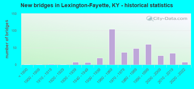
- New bridges - historical statistics
- 1Before 1900
- 11900-1909
- 21910-1919
- 11920-1929
- 81930-1939
- 71940-1949
- 201950-1959
- 1051960-1969
- 371970-1979
- 481980-1989
- 601990-1999
- 272000-2009
- 342010-2019
- 82020-2022
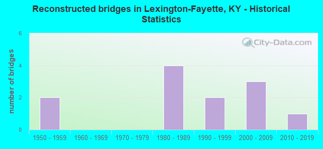
- Reconstructed bridges - Historical Statistics
- 21950-1959
- 01960-1969
- 01970-1979
- 41980-1989
- 21990-1999
- 32000-2009
- 12010-2019
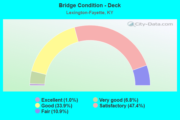
- Bridge Condition - Deck
- 1.0%Excellent
- 6.8%Very good
- 33.9%Good
- 47.4%Satisfactory
- 10.9%Fair
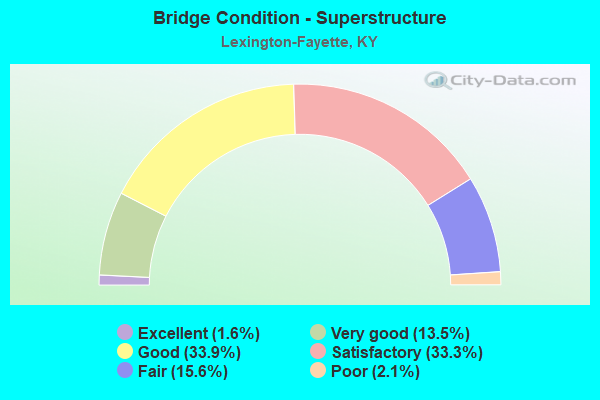
- Bridge Condition - Superstructure
- 1.6%Excellent
- 13.5%Very good
- 33.9%Good
- 33.3%Satisfactory
- 15.6%Fair
- 2.1%Poor
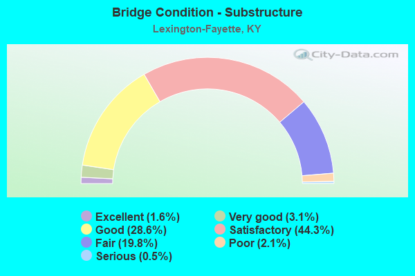
- Bridge Condition - Substructure
- 1.6%Excellent
- 3.1%Very good
- 28.6%Good
- 44.3%Satisfactory
- 19.8%Fair
- 2.1%Poor
- 0.5%Serious
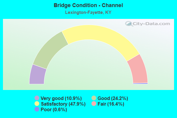
- Bridge Condition - Channel
- 10.9%Very good
- 24.2%Good
- 47.9%Satisfactory
- 16.4%Fair
- 0.6%Poor
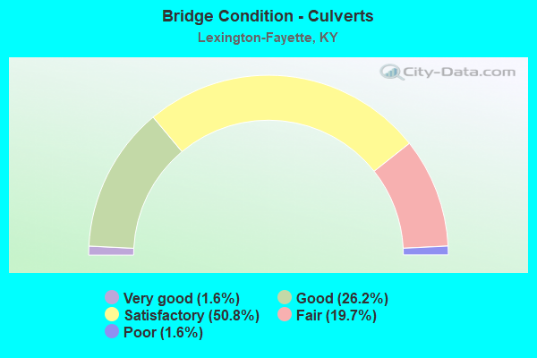
- Bridge Condition - Culverts
- 1.6%Very good
- 26.2%Good
- 50.8%Satisfactory
- 19.7%Fair
- 1.6%Poor
Find on map >> Show street view
Structure Number: 34B00152R, Location: 2.1 MI. E. JCT I-64&I-75 (Lat: 38.061111, Lng: -84.400556), Route carried "under" structure: County highway 1004, Year Built: 1998, Structure Length: 0. m, Average Daily Traffic: 433 (year 2006), Features Intersected: ROYSTER ROAD, Facility Carried by Structure: E I-64
Minimum Vertical Clearance: 5.54m (18.18ft), Kilometerpoint: 1.305, Lanes on structure: 3, Lanes under structure: 2, Material/Design: Prestressed concrete continuous, Design/Construction: Box Beam or Girders - Single/Spread, Length of Maximum Span: 20.0m (65.6ft)
Find on map >> Show street view
Structure Number: 34B00153N, Location: @ MADISON CO LINE (Lat: 37.883889, Lng: -84.339722), Route carried "under" structure: State highway 2328, Year Built: 1998, Structure Length: 0. m, Average Daily Traffic: 1,820 (year 2018), Features Intersected: KY 2328 & KY RIVER, Facility Carried by Structure: I-75
Minimum Vertical Clearance: 0.00m, Kilometerpoint: 0.425, Lanes on structure: 6, Lanes under structure: 2, Material/Design: Steel continuous, Design/Construction: Truss - Deck, Length of Maximum Span: 136.6m (448.2ft)
Find on map >> Show street view
Structure Number: 34B00157N, Location: 1.89 MI WEST JCT I 75 (Lat: 38.042778, Lng: -84.454167), Route carried "under" structure: State highway 4, Year Built: 1998, Structure Length: 0. m, Average Daily Traffic: 39,049 (year 2019), Truck Traffic: 6%, Features Intersected: US 60 OVER KY 4, Facility Carried by Structure: WINCHESTER ROAD
Minimum Vertical Clearance: 5.41m (17.75ft), Kilometerpoint: 20.493, Lanes on structure: 6, Lanes under structure: 6, Material/Design: Steel continuous, Design/Construction: Stringer/Multi-beam, Length of Maximum Span: 21.0m (68.9ft)
Find on map >> Show street view
Structure Number: 34B00158N, Location: 1.5 MI. N.E. OF JCT US 60 (Lat: 38.044722, Lng: -84.323333), Route carried "under" structure: Interstate 64, Year Built: 2003, Structure Length: 0. m, Average Daily Traffic: 40,128 (year 2017), Truck Traffic: 14%, Features Intersected: I-64, Facility Carried by Structure: KY 859 (HALEY RD)
Minimum Vertical Clearance: 5.61m (18.41ft), Kilometerpoint: 140.727, Lanes on structure: 2, Lanes under structure: 6, Material/Design: Prestressed concrete continuous, Design/Construction: Stringer/Multi-beam, Length of Maximum Span: 39.6m (129.9ft)
Find on map >> Show street view
Structure Number: 34B00163N, Location: 1 MI. EAST OF JCT KY 4 (Lat: 38.061111, Lng: -84.516389), Route carried "under" structure: Ramp City street 1307, Year Built: 2005, Structure Length: 0. m, Average Daily Traffic: 3,540 (year 2009), Features Intersected: SOUTHERN RR, Facility Carried by Structure: US-421
Minimum Vertical Clearance: 4.90m (16.08ft), Kilometerpoint: 0.116, Lanes on structure: 2, Lanes under structure: 2, Material/Design: Steel continuous, Design/Construction: Stringer/Multi-beam, Length of Maximum Span: 45.7m (149.9ft)
Find on map >> Show street view
Structure Number: 34B00168N, Location: US 60 / NEW CIRCLE RD (Lat: 38.045833, Lng: -84.563333), Route carried "under" structure: US 60, Year Built: 2016, Structure Length: 0. m, Average Daily Traffic: 23,058 (year 2020), Truck Traffic: 5%, Features Intersected: US 60 (VERSAILLES RD), Facility Carried by Structure: RAMP G NEW CIRCLE
Minimum Vertical Clearance: 5.05m (16.57ft), Kilometerpoint: 7.757, Lanes on structure: 2, Lanes under structure: 4, Material/Design: Steel continuous, Design/Construction: Stringer/Multi-beam, Length of Maximum Span: 25.9m (85.0ft)
Find on map >> Show street view
Structure Number: 34B00169N, Location: .87MI NORTH OF US 60 (Lat: 38.055833, Lng: -84.556667), Route carried "under" structure: City street 4009, Year Built: 2016, Structure Length: 0. m, Average Daily Traffic: 7,126 (year 2018), Features Intersected: ALEXANDRIA DR, Facility Carried by Structure: KY 4 (NEW CIRCLE)
Minimum Vertical Clearance: 6.38m (20.93ft), Kilometerpoint: 3.642, Lanes on structure: 6, Lanes under structure: 2, Material/Design: Prestressed concrete continuous, Design/Construction: Box Beam or Girders - Single/Spread, Length of Maximum Span: 25.9m (85.0ft)
Find on map >> Show street view
Structure Number: 34B00171N, Location: .9MI E OF ALEXANDRIA DR (Lat: 38.061944, Lng: -84.543333), Route carried "under" structure: State highway 4, Year Built: 2015, Structure Length: 0. m, Average Daily Traffic: 56,463 (year 2020), Truck Traffic: 12%, Features Intersected: NEW CIRCLE RD, Facility Carried by Structure: KY 1681
Minimum Vertical Clearance: 5.58m (18.31ft), Kilometerpoint: 10.206, Lanes on structure: 2, Lanes under structure: 6, Material/Design: Concrete continuous, Design/Construction: Stringer/Multi-beam, Length of Maximum Span: 31.7m (104.0ft)
Find on map >> Show street view
Structure Number: 34B00174N, Location: 1.9 MI W OF JCT KY 1973 (Lat: 37.996111, Lng: -84.397222), Route carried "under" structure: Interstate 75, Year Built: 2016, Structure Length: 0. m, Average Daily Traffic: 52,557 (year 2020), Truck Traffic: 22%, Features Intersected: I 75, Facility Carried by Structure: KY 1927
Minimum Vertical Clearance: 5.18m (16.99ft), Kilometerpoint: 171.036, Lanes on structure: 4, Lanes under structure: 6, Material/Design: Prestressed concrete, Design/Construction: Stringer/Multi-beam, Length of Maximum Span: 31.5m (103.3ft)
Find on map >> Show street view
Structure Number: 34B00180N, Location: 0.8M S of JCT Citation (Lat: 38.074444, Lng: -84.495278), Route carried "under" structure: State highway 4, Year Built: 2019, Structure Length: 0. m, Average Daily Traffic: 53,287 (year 2018), Truck Traffic: 8%, Features Intersected: NEW CIRCLE ROAD, Facility Carried by Structure: KY-922
Minimum Vertical Clearance: 5.11m (16.77ft), Kilometerpoint: 15.006, Lanes on structure: 4, Lanes under structure: 4, Material/Design: Prestressed concrete continuous, Design/Construction: Stringer/Multi-beam, Length of Maximum Span: 39.3m (128.9ft)
Find on map >> Show street view
Structure Number: 34B00181N, Location: Over Ky 4 - New Circle rd (Lat: 38.074722, Lng: -84.505833), Route carried "under" structure: State highway 4, Year Built: 2020, Structure Length: 0. m, Average Daily Traffic: 53,287 (year 2018), Truck Traffic: 8%, Features Intersected: NEW CIRCLE RD, Facility Carried by Structure: US-25
Minimum Vertical Clearance: 5.43m (17.81ft), Kilometerpoint: 14.053, Lanes on structure: 4, Lanes under structure: 4, Material/Design: Prestressed concrete continuous, Design/Construction: Stringer/Multi-beam, Length of Maximum Span: 28.0m (91.9ft)
Find on map >> Show street view
Structure Number: 34C00054N, Location: @ JCT US 25 (VINE ST) (Lat: 38.044444, Lng: -84.496389), Route carried "under" structure: City street 7012, Year Built: 1990, Structure Length: 0. m, Features Intersected: US 25 (VINE ST), Facility Carried by Structure: S MARTIN LUTHER KI
Minimum Vertical Clearance: 30+ m (98+ ft), Kilometerpoint: 0.570, Lanes on structure: 2, Lanes under structure: 2, Material/Design: Prestressed concrete continuous, Design/Construction: Box Beam or Girders - Single/Spread, Length of Maximum Span: 23.3m (76.4ft)
Find on map >> Show street view
Structure Number: 34C00054N, Location: @ JCT US 25 (VINE ST) (Lat: 38.044444, Lng: -84.496389), Route carried "under" structure: US 25, Year Built: 1990, Structure Length: 0. m, Average Daily Traffic: 17,495 (year 2019), Truck Traffic: 3%, Features Intersected: US 25 (VINE ST), Facility Carried by Structure: S MARTIN LUTHER KI
Minimum Vertical Clearance: 30+ m (98+ ft), Kilometerpoint: 22.243, Lanes on structure: 2, Lanes under structure: 3, Material/Design: Prestressed concrete continuous, Design/Construction: Box Beam or Girders - Single/Spread, Length of Maximum Span: 23.3m (76.4ft)
Find on map >> Show street view
Structure Number: 34C00088N, Location: .2MI W OF KY 922 (Lat: 38.073889, Lng: -84.490833), Route carried "under" structure: State highway 4, Year Built: 2020, Structure Length: 0. m, Average Daily Traffic: 43,815 (year 2018), Truck Traffic: 6%, Features Intersected: KY 4 NEW CIRCLE RD, Facility Carried by Structure: LEXMARK ACCES RD
Minimum Vertical Clearance: 5.74m (18.83ft), Kilometerpoint: 15.392, Lanes on structure: 2, Lanes under structure: 4, Material/Design: Prestressed concrete, Design/Construction: Stringer/Multi-beam, Length of Maximum Span: 24.9m (81.7ft)
Find on map >> Show street view
Structure Number: 34R00600N, Location: 300FT EAST OF JCT US 27N (Lat: 38.066944, Lng: -84.471944), Route carried "under" structure: State highway 4, Year Built: 1951, Structure Length: 0. m, Average Daily Traffic: 33,998 (year 2020), Truck Traffic: 7%, Features Intersected: NEW CIRCLE ROAD, Facility Carried by Structure: CSX RR OVER NC
Minimum Vertical Clearance: 4.17m (13.68ft), Kilometerpoint: 17.283, Lanes under structure: 4, Material/Design: Steel, Design/Construction: Stringer/Multi-beam, Length of Maximum Span: 13.1m (43.0ft)
Find on map >> Show street view
Structure Number: 34R00602N, Location: 90FT SOU OF LOUDEN NTRSCT (Lat: 38.059444, Lng: -84.485000), Route carried "under" structure: US 27, Year Built: 1904, Structure Length: 0. m, Average Daily Traffic: 18,920 (year 2019), Truck Traffic: 10%, Features Intersected: NORTH BROADWAY, Facility Carried by Structure: RJ CORMAN RR
Minimum Vertical Clearance: 4.47m (14.67ft), Kilometerpoint: 12.587, Lanes under structure: 4, Material/Design: Steel, Design/Construction: Stringer/Multi-beam, Length of Maximum Span: 18.3m (60.0ft)
Find on map >> Show street view
Structure Number: 34R00603N, Location: 300 Ft. S OF N-JCT.KY 4 (Lat: 38.066667, Lng: -84.474167), Route carried "under" structure: US 27, Year Built: 1937, Structure Length: 0. m, Average Daily Traffic: 15,447 (year 2019), Truck Traffic: 10%, Features Intersected: US 27, Facility Carried by Structure: RJ CORMAN
Minimum Vertical Clearance: 4.06m (13.32ft), Kilometerpoint: 13.873, Lanes under structure: 4, Material/Design: Steel, Design/Construction: Stringer/Multi-beam, Length of Maximum Span: 20.9m (68.6ft)
Find on map >> Show street view
Structure Number: 34R00604N, Location: 1.0 MI SOUTH OF SCOTT CL (Lat: 38.121944, Lng: -84.604722), Route carried "under" structure: US 421, Year Built: 1930, Structure Length: 0. m, Average Daily Traffic: 10,100 (year 2018), Truck Traffic: 9%, Features Intersected: US 421, Facility Carried by Structure: CSX RR
Minimum Vertical Clearance: 4.19m (13.75ft), Kilometerpoint: 11.500, Lanes under structure: 2, Material/Design: Concrete, Design/Construction: Culvert, Length of Maximum Span: 9.1m (29.9ft)
Find on map >> Show street view
Structure Number: 34R00605N, Location: .3 MI.W OF KY 922 (Lat: 38.055000, Lng: -84.514722), Route carried "under" structure: State highway 1681, Year Built: 1911, Structure Length: 0. m, Average Daily Traffic: 4,266 (year 2020), Truck Traffic: 19%, Features Intersected: MANCHESTER ST/RJ CORMAN, Facility Carried by Structure: NS (CN&TP) SYS
Minimum Vertical Clearance: 6.10m (20.01ft), Kilometerpoint: 11.589, Lanes under structure: 2, Material/Design: Steel, Design/Construction: Stringer/Multi-beam, Length of Maximum Span: 22.5m (73.8ft)
Find on map >> Show street view
Structure Number: 34R00607N, Location: 100' S OF JCT US 27 (Lat: 38.077778, Lng: -84.451111), Route carried "under" structure: City street 2515, Year Built: 1940, Structure Length: 0. m, Average Daily Traffic: 6,714 (year 2020), Features Intersected: OLD PARIS ROAD, Facility Carried by Structure: CSX RAILROAD
Kilometerpoint: 2.202, Lanes under structure: 2, Material/Design: Steel, Design/Construction: Stringer/Multi-beam, Length of Maximum Span: 12.2m (40.0ft)
Find on map >> Show street view
Structure Number: 34R00608N, Location: .2 MI W. JCT US 27 (Lat: 37.992778, Lng: -84.528611), Route carried "under" structure: City street 4910, Year Built: 2004, Structure Length: 0. m, Average Daily Traffic: 13,947 (year 2020), Truck Traffic: 3%, Features Intersected: REYNOLDS ROAD, Facility Carried by Structure: SOUTHERN RR
Minimum Vertical Clearance: 5.08m (16.67ft), Kilometerpoint: 0.925, Lanes under structure: 4, Material/Design: Steel, Design/Construction: Stringer/Multi-beam, Length of Maximum Span: 19.5m (64.0ft)
Find on map >> Show street view
Structure Number: 34X00001N, Location: 160 FT North of High St. (Lat: 38.048056, Lng: -84.501389), Route carried "under" structure: US 27, Year Built: 1978, Structure Length: 0. m, Average Daily Traffic: 23,445 (year 2018), Truck Traffic: 7%, Features Intersected: S. BROADWAY, Facility Carried by Structure: PEDWAY
Minimum Vertical Clearance: 7.95m (26.08ft), Kilometerpoint: 10.683, Lanes under structure: 4, Material/Design: Prestressed concrete, Design/Construction: Box Beam or Girders - Multiple, Length of Maximum Span: 27.7m (90.9ft)
Find on map >> Show street view
Structure Number: 34X00002N, Location: S OF MASON HEADLY RD (Lat: 38.033056, Lng: -84.524722), Route carried "under" structure: US 68, Year Built: 1982, Structure Length: 0. m, Average Daily Traffic: 31,889 (year 2020), Truck Traffic: 1%, Features Intersected: SOUTH BROADWAY, Facility Carried by Structure: ST JOE PED BRIDGE
Minimum Vertical Clearance: 8.13m (26.67ft), Kilometerpoint: 8.085, Lanes under structure: 4, Material/Design: Prestressed concrete, Design/Construction: Box Beam or Girders - Multiple, Length of Maximum Span: 32.0m (105.0ft)
Find on map >> Show street view
Structure Number: 34X00003N, Location: 50 FT South of US 27 (Lat: 38.048056, Lng: -84.500556), Route carried "under" structure: US 25, Year Built: 1982, Structure Length: 0. m, Average Daily Traffic: 11,751 (year 2020), Truck Traffic: 11%, Features Intersected: US-25, Facility Carried by Structure: RADISON PED.BRIDGE
Minimum Vertical Clearance: 5.54m (18.18ft), Kilometerpoint: 22.742, Lanes under structure: 3, Material/Design: Steel continuous, Design/Construction: Girder and Floorbeam System, Length of Maximum Span: 22.0m (72.2ft)
Find on map >> Show street view
Structure Number: 34X00004N, Location: 150 FT North of US 25 (Lat: 38.049167, Lng: -84.499444), Route carried "under" structure: US 27, Year Built: 1985, Structure Length: 0. m, Average Daily Traffic: 18,920 (year 2019), Truck Traffic: 10%, Features Intersected: N. BROADWAY (US 27), Facility Carried by Structure: PEDWAY
Minimum Vertical Clearance: 7.41m (24.31ft), Kilometerpoint: 10.889, Lanes under structure: 4, Material/Design: Prestressed concrete, Design/Construction: Box Beam or Girders - Multiple, Length of Maximum Span: 25.3m (83.0ft)
Find on map >> Show street view
Structure Number: 34X00005N, Location: 250' EAST JCT US 27 (Lat: 38.048611, Lng: -84.499444), Route carried "under" structure: US 25, Year Built: 1989, Structure Length: 0. m, Average Daily Traffic: 17,495 (year 2019), Truck Traffic: 3%, Features Intersected: E. MAIN ST., Facility Carried by Structure: PEDESTRIAN WALKWAY
Minimum Vertical Clearance: 4.98m (16.34ft), Kilometerpoint: 22.755, Lanes under structure: 3, Material/Design: Steel continuous, Design/Construction: Girder and Floorbeam System, Length of Maximum Span: 18.9m (62.0ft)
Find on map >> Show street view
Structure Number: 34X00006N, Location: 300' EAST JCT VINE ST (Lat: 38.047778, Lng: -84.499167), Route carried "under" structure: City street 4744, Year Built: 1990, Structure Length: 0. m, Average Daily Traffic: 1,537 (year 2019), Features Intersected: S Mill St, Facility Carried by Structure: Pedway
Minimum Vertical Clearance: 4.50m (14.76ft), Kilometerpoint: 0.042, Lanes under structure: 2, Material/Design: Steel continuous, Design/Construction: Girder and Floorbeam System, Length of Maximum Span: 21.9m (71.9ft)
Find on map >> Show street view
Structure Number: 34X00007N, Location: 500' NORTH JCT US 27 (Lat: 38.032222, Lng: -84.507500), Route carried "under" structure: State lands road 8104, Year Built: 1991, Structure Length: 0. m, Average Daily Traffic: 25,477 (year 2006), Features Intersected: ROSE STREET, Facility Carried by Structure: PED OH-OVR ROSE ST
Minimum Vertical Clearance: 6.02m (19.75ft), Kilometerpoint: 0.570, Lanes under structure: 3, Material/Design: Prestressed concrete, Design/Construction: Stringer/Multi-beam, Length of Maximum Span: 23.8m (78.1ft)
Find on map >> Show street view
Structure Number: 34X00007N, Location: 500' NORTH JCT US 27 (Lat: 38.032222, Lng: -84.507500), Route carried "under" structure: State lands road 8104, Year Built: 1991, Structure Length: 0. m, Average Daily Traffic: 25,477 (year 2006), Features Intersected: ROSE STREET, Facility Carried by Structure: PED OH-OVR ROSE ST
Minimum Vertical Clearance: 6.02m (19.75ft), Kilometerpoint: 0.126, Lanes under structure: 2, Material/Design: Prestressed concrete, Design/Construction: Stringer/Multi-beam, Length of Maximum Span: 23.8m (78.1ft)
Find on map >> Show street view
Structure Number: 34X00008N, Location: 300 FT EAST JCT US 27 (Lat: 38.027500, Lng: -84.509167), Route carried "under" structure: City street 3223, Year Built: 1991, Structure Length: 0. m, Average Daily Traffic: 9,395 (year 2020), Features Intersected: Cooper Drive, Facility Carried by Structure: Ped Over Cooper
Kilometerpoint: 0.150, Lanes under structure: 3, Material/Design: Steel, Design/Construction: Truss - Thru, Length of Maximum Span: 28.3m (92.8ft)
Find on map >> Show street view
Structure Number: 34X00010N, Location: 300' WEST OF LIMESTONE (Lat: 38.030864, Lng: -84.510286), Route carried "under" structure: City street 4192, Year Built: 2016, Structure Length: 0. m, Features Intersected: CONN TERRACE, Facility Carried by Structure: PEDESTRIAN WALKWAY
Minimum Vertical Clearance: 9.02m (29.59ft), Kilometerpoint: 0.338, Lanes under structure: 1, Material/Design: Steel, Length of Maximum Span: 27.3m (89.6ft)
Find on map >> Show street view
Structure Number: 34X00011N, Location: 300 FT N SOUTH LIMESTONE (Lat: 38.031389, Lng: -84.508611), Route carried "under" structure: State lands road 8104, Structure Length: 0. m, Features Intersected: Hospital Drive, Facility Carried by Structure: UK Pedway
Minimum Vertical Clearance: 5.77m (18.93ft), Kilometerpoint: 0.229, Lanes under structure: 2, Length of Maximum Span: 8.5m (27.9ft)
Find on map >> Show street view
Structure Number: 34X00012N, Location: 200 FT S. Transcript Ave. (Lat: 38.030833, Lng: -84.510000), Route carried "under" structure: City street 4192, Year Built: 2010, Structure Length: 0. m, Features Intersected: South Limestone, Facility Carried by Structure: UK Pedway
Kilometerpoint: 0.364, Lanes under structure: 1, Material/Design: Steel, Design/Construction: Truss - Thru, Length of Maximum Span: 46.0m (150.9ft)
Find on map >> Show street view
Structure Number: 34X00012N, Location: 200 FT S. Transcript Ave. (Lat: 38.030833, Lng: -84.510000), Route carried "under" structure: US 27, Year Built: 2010, Structure Length: 0. m, Average Daily Traffic: 25,993 (year 2020), Features Intersected: South Limestone, Facility Carried by Structure: UK Pedway
Minimum Vertical Clearance: 6.93m (22.74ft), Kilometerpoint: 7.741, Lanes under structure: 4, Material/Design: Steel, Design/Construction: Truss - Thru, Length of Maximum Span: 46.0m (150.9ft)
Find on map >> Show street view
Structure Number: 34X00013N, Location: 300 FT S. Virginia Ave. (Lat: 38.033889, Lng: -84.508611), Route carried "under" structure: US 27, Structure Length: 0. m, Average Daily Traffic: 25,993 (year 2020), Features Intersected: South Limestone, Facility Carried by Structure: UK Pedway
Minimum Vertical Clearance: 5.16m (16.93ft), Kilometerpoint: 8.148, Lanes under structure: 4, Length of Maximum Span: 24.6m (80.7ft)
Find on map >> Show street view
Structure Number: 34X00014N, Location: .2 mi S. Ave.of Champions (Lat: 38.040556, Lng: -84.505000), Route carried "under" structure: City street 7087, Year Built: 1995, Structure Length: 0. m, Average Daily Traffic: 12,720 (year 2020), Features Intersected: South Limestone, Facility Carried by Structure: UK Pedway
Minimum Vertical Clearance: 6.43m (21.10ft), Kilometerpoint: 0.719, Lanes under structure: 2, Material/Design: Prestressed concrete continuous, Design/Construction: Girder and Floorbeam System, Length of Maximum Span: 23.3m (76.4ft)
Find on map >> Show street view
Structure Number: 34X00015N, Location: 100' E. of S. Limestone (Lat: 38.042778, Lng: -84.500556), Route carried "under" structure: City street 3288, Year Built: 1995, Structure Length: 0. m, Average Daily Traffic: 8,050 (year 2019), Features Intersected: East Maxwell, Facility Carried by Structure: Pedway
Minimum Vertical Clearance: 5.13m (16.83ft), Kilometerpoint: 0.085, Lanes under structure: 2, Material/Design: Concrete, Design/Construction: Girder and Floorbeam System, Length of Maximum Span: 24.8m (81.4ft)
Find on map >> Show street view
Structure Number: 34X00016N, Location: 100' S. of Bob-O-Link (Lat: 38.032778, Lng: -84.527222), Route carried "under" structure: City street 4774, Year Built: 2000, Structure Length: 0. m, Features Intersected: Shaker Drive, Facility Carried by Structure: Pedway
Minimum Vertical Clearance: 9.22m (30.25ft), Kilometerpoint: 0.267, Lanes under structure: 2, Material/Design: Steel, Design/Construction: Truss - Deck, Length of Maximum Span: 18.9m (62.0ft)
Find on map >> Show street view
Structure Number: 34X00017N, Location: .1 W of US 68 (Lat: 38.032778, Lng: -84.526389), Route carried "under" structure: City street 4081, Year Built: 2000, Structure Length: 0. m, Features Intersected: Bob-O-Link, Facility Carried by Structure: Pedway
Minimum Vertical Clearance: 12.32m (40.42ft), Kilometerpoint: 1.104, Lanes under structure: 2, Material/Design: Steel, Design/Construction: Truss - Deck, Length of Maximum Span: 35.9m (117.8ft)
Find on map >> Show street view
Structure Number: 76B00039N, Location: @N-JCT I-75 & US 421 (Lat: 37.876389, Lng: -84.333056), Route carried "under" structure: Interstate 75, Year Built: 1962, Structure Length: 0. m, Average Daily Traffic: 64,439 (year 2020), Truck Traffic: 19%, Features Intersected: I-75, Facility Carried by Structure: US-25
Minimum Vertical Clearance: 6.07m (19.91ft), Kilometerpoint: 156.168, Lanes on structure: 2, Lanes under structure: 6, Material/Design: Concrete continuous, Design/Construction: Tee Beam, Length of Maximum Span: 22.9m (75.1ft)
Find on map >> Show street view
Structure Number: 76B00123N, Location: .1 Mi E of JCT US25&421 (Lat: 37.843611, Lng: -84.327222), Route carried "under" structure: Interstate 75, Year Built: 2020, Structure Length: 0. m, Average Daily Traffic: 62,272 (year 2020), Truck Traffic: 19%, Features Intersected: I75, Facility Carried by Structure: KY-627
Minimum Vertical Clearance: 4.95m (16.24ft), Kilometerpoint: 152.437, Lanes on structure: 4, Lanes under structure: 6, Material/Design: Prestressed concrete continuous, Design/Construction: Stringer/Multi-beam, Length of Maximum Span: 37.3m (122.4ft)
Find on map >> Show street view
Structure Number: 105B00083N, Location: 1.2 MI S OF JCT KY 1973 (Lat: 38.157778, Lng: -84.612222), Route carried "under" structure: Interstate 64, Year Built: 1973, Structure Length: 0. m, Average Daily Traffic: 34,704 (year 2016), Truck Traffic: 19%, Features Intersected: I 64, Facility Carried by Structure: US-62
Minimum Vertical Clearance: 5.08m (16.67ft), Kilometerpoint: 110.964, Lanes on structure: 2, Lanes under structure: 4, Material/Design: Concrete continuous, Design/Construction: Tee Beam, Length of Maximum Span: 25.7m (84.3ft)