Bridge Statistics for Lexington-Fayette, Kentucky (KY)
Condition, Traffic, Stress, Structural Evaluation, Project Costs
- National Bridge Inventory (NBI) Statistics
- 361Number of bridges
- 3,258ft / 993mTotal length
- $66,128,000Total costs
- 7,023,698Total average daily traffic
- 786,324Total average daily truck traffic
- National Bridge Inventory (NBI) Registered Bridges for Lexington-Fayette
- No street view available for this location
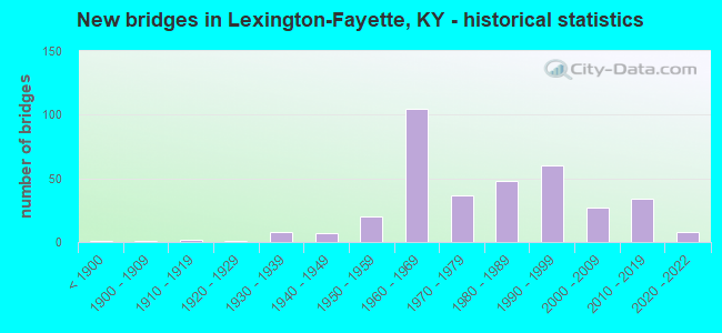
- New bridges - historical statistics
- 1Before 1900
- 11900-1909
- 21910-1919
- 11920-1929
- 81930-1939
- 71940-1949
- 201950-1959
- 1051960-1969
- 371970-1979
- 481980-1989
- 601990-1999
- 272000-2009
- 342010-2019
- 82020-2022
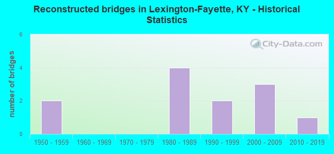
- Reconstructed bridges - Historical Statistics
- 21950-1959
- 01960-1969
- 01970-1979
- 41980-1989
- 21990-1999
- 32000-2009
- 12010-2019
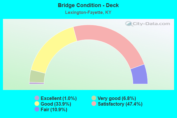
- Bridge Condition - Deck
- 1.0%Excellent
- 6.8%Very good
- 33.9%Good
- 47.4%Satisfactory
- 10.9%Fair
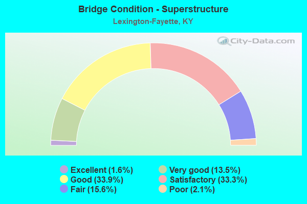
- Bridge Condition - Superstructure
- 1.6%Excellent
- 13.5%Very good
- 33.9%Good
- 33.3%Satisfactory
- 15.6%Fair
- 2.1%Poor
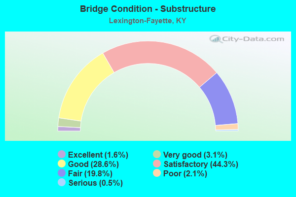
- Bridge Condition - Substructure
- 1.6%Excellent
- 3.1%Very good
- 28.6%Good
- 44.3%Satisfactory
- 19.8%Fair
- 2.1%Poor
- 0.5%Serious
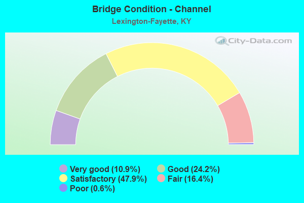
- Bridge Condition - Channel
- 10.9%Very good
- 24.2%Good
- 47.9%Satisfactory
- 16.4%Fair
- 0.6%Poor
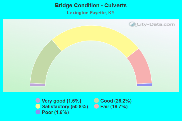
- Bridge Condition - Culverts
- 1.6%Very good
- 26.2%Good
- 50.8%Satisfactory
- 19.7%Fair
- 1.6%Poor
Find on map >> Show street view
Structure Number: 105C00105N, Location: .1 MI N JCT KY 922 (Lat: 38.206667, Lng: -84.483611), Route carried "on" structure: County highway 1111, Year Built: 1999, Status: Open, Structure Length: 2.80m (9.19ft), Average Daily Traffic: 259 (year 2012), Average Future Daily Traffic: 225 (year 2032), Design Load: HS 25 or greater, Features Intersected: NORTH ELKHORN CREEK, Facility Carried by Structure: JOHNSON MILL RD
Minimum Vertical Clearance: 30+ m (98+ ft), Kilometerpoint: 1.537, Lanes on structure: 1, Owner: County Highway Agency, Approaching Roadway Width: 5.5m (18.0ft), Material/Design: Prestressed concrete, Design/Construction: Box Beam or Girders - Multiple, Number Of Spans In Main Unit: 1, Length of Maximum Span: 27.0m (88.6ft), Curb-To-Curb Width: 4.7m (15.4ft), Out-to-Out Width: 4.9m (16.1ft)
Condition: Deck: Satisfactory, Superstructure: Satisfactory, Substructure: Good, Channel: Good, Operating Rating: 84.5 metric tons, Method Used To Determine Operating Rating: Load Factor (LF), Inventory Rating: 50.7 metric tons, Method Used To Determine Inventory Rating: Load Factor (LF), Structural Evaluation: Equal to present minimum criteria, Deck Geometry: High priority of replacement, Waterway Adequacy: Better than present minimum criteria, Approach Roadway Alignment: Meets minimum limits, Designated Inspection Frequency: Every 24 months, Inspection Date: Febuary 2021, Deck Structure Type: Concrete Precast Panels, Wearing Surface/Protective System: Wearing Surface: Bituminous, Membrane: Preformed Fabric
Find on map >> Show street view
Structure Number: 120B00008N, Location: .60 MI E OF JCT KY 1967 (Lat: 38.103333, Lng: -84.641111), Route carried "on" structure: State highway 1681, Year Built: 1949, Status: Posted for load, Structure Length: 3.93m (12.89ft), Average Daily Traffic: 2,826 (year 2018), Truck Traffic: 6%, Average Future Daily Traffic: 2,486 (year 2038), Design Load: H 20, Features Intersected: SOUTH ELKHORN CREEK
Minimum Vertical Clearance: 30+ m (98+ ft), Kilometerpoint: 18.725, Lanes on structure: 2, Owner: State Highway Agency, Approaching Roadway Width: 7.0m (23.0ft), Material/Design: Concrete, Design/Construction: Tee Beam, Number Of Spans In Main Unit: 3, Length of Maximum Span: 12.2m (40.0ft), Curb or Sidewalk Widths: Left: 0.8m (2.6ft), Right: 0.8m (2.6ft), Curb-To-Curb Width: 7.3m (24.0ft), Out-to-Out Width: 9.4m (30.8ft)
Condition: Deck: Fair, Superstructure: Satisfactory, Substructure: Poor, Channel: Fair, Operating Rating: 50.6 metric tons, Method Used To Determine Operating Rating: Load Factor (LF), Inventory Rating: 30.4 metric tons, Method Used To Determine Inventory Rating: Load Factor (LF), Structural Evaluation: Meets minimum limits, Deck Geometry: High priority of replacement, Waterway Adequacy: Better than present minimum criteria, Approach Roadway Alignment: Equal to present desirable criteria, Bridge Posting: Required (Relationship of Operating Rating to Maximum Legal Load: 10.0 - 19.9% below), Designated Inspection Frequency: Every 24 months, Inspection Date: November 2020, Deck Structure Type: Concrete Cast-file-Place, Wearing Surface/Protective System: Wearing Surface: Latex Concrete
Find on map >> Show street view
Structure Number: 120B00036N, Location: 4.2 MI S JCT KY 33 @ V-SL (Lat: 37.965000, Lng: -84.676667), Route carried "on" structure: State highway 169, Year Built: 1989, Status: Open, Structure Length: 0.91m (2.99ft), Average Daily Traffic: 3,000 (year 2020), Truck Traffic: 7%, Average Future Daily Traffic: 2,640 (year 2040), Design Load: HS 25 or greater, Features Intersected: EAST FORK CLEAR CREEK
Minimum Vertical Clearance: 30+ m (98+ ft), Kilometerpoint: 0.364, Lanes on structure: 2, Owner: State Highway Agency, Approaching Roadway Width: 6.1m (20.0ft), Skew: 4 degrees, Material/Design: Prestressed concrete, Design/Construction: Box Beam or Girders - Multiple, Number Of Spans In Main Unit: 1, Length of Maximum Span: 8.4m (27.6ft), Curb-To-Curb Width: 9.2m (30.2ft), Out-to-Out Width: 9.7m (31.8ft)
Condition: Deck: Good, Superstructure: Good, Substructure: Fair, Channel: Satisfactory, Operating Rating: 76.1 metric tons, Method Used To Determine Operating Rating: Load Factor (LF), Inventory Rating: 45.6 metric tons, Method Used To Determine Inventory Rating: Load Factor (LF), Structural Evaluation: Somewhat better than minimum adequacy, Deck Geometry: Meets minimum limits, Waterway Adequacy: Better than present minimum criteria, Approach Roadway Alignment: Equal to present minimum criteria, Designated Inspection Frequency: Every 24 months, Inspection Date: November 2020, Deck Structure Type: Concrete Precast Panels, Wearing Surface/Protective System: Wearing Surface: Integral Concrete, Deck Protection: Epoxy Coated Reinforcing
Find on map >> Show street view
Structure Number: 120B00037N, Location: 3.3 MI S JCT KY 33 (Lat: 37.977500, Lng: -84.681667), Route carried "on" structure: State highway 169, Year Built: 1989, Status: Open, Structure Length: 0.70m (2.30ft), Average Daily Traffic: 3,000 (year 2020), Truck Traffic: 7%, Average Future Daily Traffic: 2,640 (year 2040), Design Load: HS 25 or greater, Features Intersected: CLEAR CREEK
Minimum Vertical Clearance: 30+ m (98+ ft), Kilometerpoint: 1.870, Lanes on structure: 2, Owner: State Highway Agency, Approaching Roadway Width: 6.7m (22.0ft), Skew: 2 degrees, Material/Design: Concrete, Design/Construction: Culvert, Number Of Spans In Main Unit: 1, Length of Maximum Span: 7.0m (23.0ft)
Condition: Channel: Very good, Culverts: Good, Operating Rating: 90.8 metric tons, Method Used To Determine Operating Rating: Load Factor (LF), Inventory Rating: 54.5 metric tons, Method Used To Determine Inventory Rating: Load Factor (LF), Structural Evaluation: Better than present minimum criteria, Waterway Adequacy: Equal to present desirable criteria, Approach Roadway Alignment: Better than present minimum criteria, Designated Inspection Frequency: Every 24 months, Inspection Date: November 2020
Find on map >> Show street view
Structure Number: 120C00004N, Location: .85 MI N OF JCT KY 1681 (Lat: 38.116111, Lng: -84.643056), Route carried "on" structure: County highway 1013, Year Built: 1949, Status: Posted for load, Structure Length: 4.40m (14.44ft), Average Daily Traffic: 1,050 (year 2011), Average Future Daily Traffic: 913 (year 2031), Features Intersected: SOUTH ELKHORN CREEK, Facility Carried by Structure: PAYNES DEPOT RD
Minimum Vertical Clearance: 30+ m (98+ ft), Kilometerpoint: 1.397, Lanes on structure: 2, Owner: County Highway Agency, Approaching Roadway Width: 7.0m (23.0ft), Material/Design: Concrete, Design/Construction: Tee Beam, Number Of Spans In Main Unit: 3, Length of Maximum Span: 13.6m (44.6ft), Curb or Sidewalk Widths: Left: 0.3m (1.0ft), Right: 0.3m (1.0ft), Curb-To-Curb Width: 7.4m (24.3ft), Out-to-Out Width: 8.6m (28.2ft)
Condition: Deck: Fair, Superstructure: Fair, Substructure: Satisfactory, Channel: Satisfactory, Operating Rating: 16.4 metric tons, Method Used To Determine Operating Rating: Field evaluation and documented engineering judgment, Inventory Rating: 16.4 metric tons, Method Used To Determine Inventory Rating: Field evaluation and documented engineering judgment, Structural Evaluation: Meets minimum limits, Deck Geometry: Meets minimum limits, Waterway Adequacy: Equal to present desirable criteria, Approach Roadway Alignment: Equal to present minimum criteria, Bridge Posting: Required (Relationship of Operating Rating to Maximum Legal Load: > 39.9% below), Designated Inspection Frequency: Every 24 months, Inspection Date: December 2020, Deck Structure Type: Concrete Cast-file-Place, Wearing Surface/Protective System: Wearing Surface: Bituminous, Membrane: Preformed Fabric
Find on map >> Show street view
Structure Number: 120C00009N, Location: 150' W OF KY 169 (Lat: 37.966389, Lng: -84.678333), Route carried "on" structure: County highway 1109, Year Built: 1971, Status: Open, Structure Length: 0.76m (2.49ft), Average Daily Traffic: 196 (year 2012), Average Future Daily Traffic: 170 (year 2032), Design Load: H 20, Features Intersected: BR OF CLEAR CREEK, Facility Carried by Structure: KIDDS MILL RD
Minimum Vertical Clearance: 30+ m (98+ ft), Kilometerpoint: 0.043, Lanes on structure: 2, Owner: County Highway Agency, Approaching Roadway Width: 5.8m (19.0ft), Material/Design: Prestressed concrete, Design/Construction: Box Beam or Girders - Multiple, Number Of Spans In Main Unit: 1, Length of Maximum Span: 6.7m (22.0ft), Curb or Sidewalk Widths: Left: 0.3m (1.0ft), Right: 0.3m (1.0ft), Curb-To-Curb Width: 7.2m (23.6ft), Out-to-Out Width: 8.4m (27.6ft)
Condition: Deck: Good, Superstructure: Satisfactory, Substructure: Satisfactory, Channel: Satisfactory, Operating Rating: 66.9 metric tons, Method Used To Determine Operating Rating: Load Factor (LF), Inventory Rating: 40.1 metric tons, Method Used To Determine Inventory Rating: Load Factor (LF), Structural Evaluation: Equal to present minimum criteria, Deck Geometry: Meets minimum limits, Waterway Adequacy: Better than present minimum criteria, Approach Roadway Alignment: Equal to present minimum criteria, Length Of Structure Improvement: 0.08m (0.26ft), Designated Inspection Frequency: Every 24 months, Inspection Date: December 2020, Bridge Improvement Cost: $89,000, Total Project Cost: $89,000, Deck Structure Type: Concrete Precast Panels, Wearing Surface/Protective System: Wearing Surface: Bituminous
Find on map >> Show street view
Structure Number: 120C00027N, Location: 1.7 MI N OF JCT 1681 (Lat: 38.126111, Lng: -84.638056), Route carried "on" structure: County highway 1013, Year Built: 1987, Status: Open, Structure Length: 1.83m (6.00ft), Average Daily Traffic: 1,050 (year 2011), Average Future Daily Traffic: 913 (year 2031), Design Load: HS 20, Features Intersected: S ELKHORN CR, Facility Carried by Structure: PAYNES DEPOT RD
Minimum Vertical Clearance: 30+ m (98+ ft), Kilometerpoint: 1.407, Lanes on structure: 2, Owner: County Highway Agency, Approaching Roadway Width: 6.1m (20.0ft), Material/Design: Prestressed concrete, Design/Construction: Box Beam or Girders - Multiple, Number Of Spans In Main Unit: 1, Length of Maximum Span: 17.3m (56.8ft), Curb-To-Curb Width: 8.2m (26.9ft), Out-to-Out Width: 8.6m (28.2ft)
Condition: Deck: Good, Superstructure: Satisfactory, Substructure: Poor, Channel: Satisfactory, Operating Rating: 74.8 metric tons, Method Used To Determine Operating Rating: Load Factor (LF), Inventory Rating: 44.8 metric tons, Method Used To Determine Inventory Rating: Load Factor (LF), Structural Evaluation: Meets minimum limits, Deck Geometry: Meets minimum limits, Waterway Adequacy: Better than present minimum criteria, Approach Roadway Alignment: High priority of corrective action, Length Of Structure Improvement: 0.18m (0.59ft), Designated Inspection Frequency: Every 12 months, Inspection Date: December 2021, Bridge Improvement Cost: $212,000, Total Project Cost: $212,000, Deck Structure Type: Concrete Precast Panels, Wearing Surface/Protective System: Wearing Surface: Bituminous
Find on map >> Show street view
Structure Number: 120C00029N, Location: 1.4 MI E JCT KY 1967 (Lat: 38.080278, Lng: -84.639444), Route carried "on" structure: County highway 1004, Year Built: 1994, Status: Open, Structure Length: 2.07m (6.79ft), Average Daily Traffic: 101 (year 2011), Average Future Daily Traffic: 87 (year 2031), Design Load: HS 25 or greater, Features Intersected: SOUTH ELKHORN CREEK, Facility Carried by Structure: PAYNES MILL RD
Minimum Vertical Clearance: 30+ m (98+ ft), Kilometerpoint: 7.105, Lanes on structure: 1, Owner: County Highway Agency, Approaching Roadway Width: 4.9m (16.1ft), Material/Design: Prestressed concrete, Design/Construction: Box Beam or Girders - Multiple, Number Of Spans In Main Unit: 1, Length of Maximum Span: 18.9m (62.0ft), Curb or Sidewalk Widths: Left: 0.2m (0.7ft), Right: 0.2m (0.7ft), Curb-To-Curb Width: 4.6m (15.1ft), Out-to-Out Width: 5.0m (16.4ft)
Condition: Deck: Good, Superstructure: Good, Substructure: Good, Channel: Fair, Operating Rating: 46.0 metric tons, Method Used To Determine Operating Rating: Load Factor (LF), Inventory Rating: 27.6 metric tons, Method Used To Determine Inventory Rating: Load Factor (LF), Structural Evaluation: Equal to present minimum criteria, Deck Geometry: High priority of replacement, Waterway Adequacy: Equal to present desirable criteria, Approach Roadway Alignment: High priority of corrective action, Designated Inspection Frequency: Every 24 months, Inspection Date: December 2020, Deck Structure Type: Concrete Precast Panels, Wearing Surface/Protective System: Wearing Surface: Bituminous
Find on map >> Show street view
Structure Number: 120C00032N, Location: .35 MI N JCT KY 1681 (Lat: 38.108889, Lng: -84.633889), Route carried "on" structure: County highway 1010, Year Built: 2001, Status: Open, Structure Length: 1.89m (6.20ft), Average Daily Traffic: 196 (year 2011), Average Future Daily Traffic: 170 (year 2031), Design Load: HS 25 or greater, Features Intersected: SOUTH ELKHORN CREEK, Facility Carried by Structure: BROWNS MILL RD
Minimum Vertical Clearance: 30+ m (98+ ft), Kilometerpoint: 0.529, Lanes on structure: 2, Owner: County Highway Agency, Approaching Roadway Width: 5.5m (18.0ft), Skew: 4 degrees, Material/Design: Prestressed concrete, Design/Construction: Box Beam or Girders - Multiple, Number Of Spans In Main Unit: 1, Length of Maximum Span: 17.8m (58.4ft), Curb-To-Curb Width: 7.0m (23.0ft), Out-to-Out Width: 7.4m (24.3ft)
Condition: Deck: Satisfactory, Superstructure: Satisfactory, Substructure: Satisfactory, Channel: Fair, Operating Rating: 88.2 metric tons, Method Used To Determine Operating Rating: Load Factor (LF), Inventory Rating: 52.9 metric tons, Method Used To Determine Inventory Rating: Load Factor (LF), Structural Evaluation: Equal to present minimum criteria, Deck Geometry: Meets minimum limits, Waterway Adequacy: Better than present minimum criteria, Approach Roadway Alignment: Meets minimum limits, Designated Inspection Frequency: Every 24 months, Inspection Date: December 2020, Deck Structure Type: Concrete Precast Panels, Wearing Surface/Protective System: Wearing Surface: Monolithic Concrete
Find on map >> Show street view
Structure Number: 120C00037N, Location: 500 FT W OF 169 (Lat: 37.972778, Lng: -84.682222), Route carried "on" structure: County highway 1119, Year Built: 2012, Status: Open, Structure Length: 1.28m (4.20ft), Average Daily Traffic: 300 (year 2012), Average Future Daily Traffic: 495 (year 2032), Design Load: HS 25 or greater, Features Intersected: Branch of Clear Creek, Facility Carried by Structure: Delaney Ferry Road
Minimum Vertical Clearance: 30+ m (98+ ft), Kilometerpoint: 6.751, Lanes on structure: 2, Owner: County Highway Agency, Approaching Roadway Width: 5.2m (17.1ft), Material/Design: Prestressed concrete, Design/Construction: Box Beam or Girders - Multiple, Number Of Spans In Main Unit: 1, Length of Maximum Span: 11.9m (39.0ft), Curb-To-Curb Width: 6.9m (22.6ft), Out-to-Out Width: 7.3m (24.0ft)
Condition: Deck: Good, Superstructure: Very good, Substructure: Good, Channel: Very good, Operating Rating: 76.1 metric tons, Method Used To Determine Operating Rating: Load Factor (LF), Inventory Rating: 45.6 metric tons, Method Used To Determine Inventory Rating: Load Factor (LF), Structural Evaluation: Better than present minimum criteria, Deck Geometry: Meets minimum limits, Waterway Adequacy: Equal to present desirable criteria, Approach Roadway Alignment: Equal to present minimum criteria, Designated Inspection Frequency: Every 24 months, Inspection Date: December 2020, Deck Structure Type: Concrete Precast Panels, Wearing Surface/Protective System: Wearing Surface: Bituminous
Find on map >> Show street view
Structure Number: 120C00041N, Location: 1.8mi North of ky1681 (Lat: 38.128056, Lng: -84.636667), Route carried "on" structure: County highway 1015, Year Built: 2019, Status: Open, Structure Length: 2.55m (8.37ft), Average Daily Traffic: 976 (year 2020), Average Future Daily Traffic: 2,039 (year 2039), Design Load: Greater than HL93, Features Intersected: South Elkhorn Creek, Facility Carried by Structure: Weisenberger Mill
Minimum Vertical Clearance: 30+ m (98+ ft), Kilometerpoint: 4.052, Lanes on structure: 1, Owner: County Highway Agency, Approaching Roadway Width: 5.7m (18.7ft), Material/Design: Steel, Design/Construction: Truss - Thru, Number Of Spans In Main Unit: 1, Length of Maximum Span: 24.4m (80.1ft), Curb-To-Curb Width: 3.7m (12.1ft), Out-to-Out Width: 4.3m (14.1ft)
Condition: Deck: Very good, Superstructure: Very good, Substructure: Satisfactory, Channel: Satisfactory, Operating Rating: 45.4 metric tons, Method Used To Determine Operating Rating: Load and Resistance Factor Rating (LRFR) rating reported by rating factor(RF) method using HL-93 loadings, Inventory Rating: 35.0 metric tons, Method Used To Determine Inventory Rating: Load and Resistance Factor Rating (LRFR) rating reported by rating factor(RF) method using HL-93 loadings, Structural Evaluation: Equal to present minimum criteria, Deck Geometry: High priority of replacement, Waterway Adequacy: Better than present minimum criteria, Approach Roadway Alignment: Meets minimum limits, Designated Inspection Frequency: Every 12 months, Critical Feature Inspection Frequency: Every 24 months, Inspection Date: December 2021, Critical Feature Inspection Date: December 2021, Deck Structure Type: Concrete Cast-file-Place, Wearing Surface/Protective System: Wearing Surface: Monolithic Concrete, Deck Protection: Epoxy Coated Reinforcing
Find on map >> Show street view
Structure Number: 25B00103N, Location: .4 MI. N. JCT US 60 (Lat: 38.034722, Lng: -84.273333), Route carried "under" structure: Interstate 64, Year Built: 2005, Structure Length: 0. m, Average Daily Traffic: 40,128 (year 2017), Truck Traffic: 14%, Features Intersected: KY 1678 OVER I-64, Facility Carried by Structure: KY-1678
Minimum Vertical Clearance: 5.41m (17.75ft), Kilometerpoint: 145.325, Lanes on structure: 2, Lanes under structure: 6, Material/Design: Prestressed concrete continuous, Design/Construction: Stringer/Multi-beam, Length of Maximum Span: 37.7m (123.7ft)
Find on map >> Show street view
Structure Number: 25R00604N, Location: 1.0 MI NORTH OF I-64 OP (Lat: 38.049444, Lng: -84.272222), Route carried "under" structure: State highway 1678, Year Built: 1930, Structure Length: 0. m, Average Daily Traffic: 1,256 (year 2020), Features Intersected: KY-1678, Facility Carried by Structure: CSX RAILROAD
Minimum Vertical Clearance: 4.32m (14.17ft), Kilometerpoint: 2.634, Lanes under structure: 2, Material/Design: Steel, Design/Construction: Girder and Floorbeam System, Length of Maximum Span: 16.7m (54.8ft)
Find on map >> Show street view
Structure Number: 34B00001N, Location: 1.2 MI S OF JCT KY 1973 (Lat: 38.131111, Lng: -84.528889), Route carried "under" structure: Interstate 75, Year Built: 1963, Structure Length: 0. m, Average Daily Traffic: 53,109 (year 2020), Truck Traffic: 21%, Features Intersected: I-75, Facility Carried by Structure: US-25
Minimum Vertical Clearance: 5.13m (16.83ft), Kilometerpoint: 191.082, Lanes on structure: 2, Lanes under structure: 6, Material/Design: Steel, Design/Construction: Stringer/Multi-beam, Length of Maximum Span: 38.1m (125.0ft)
Find on map >> Show street view
Structure Number: 34B00002N, Location: 2.75 MI N OF NEW CIRCL RD (Lat: 38.114722, Lng: -84.520833), Route carried "under" structure: Interstate 75, Year Built: 1964, Structure Length: 0. m, Average Daily Traffic: 77,875 (year 2020), Truck Traffic: 21%, Features Intersected: I-64, Facility Carried by Structure: US-25
Minimum Vertical Clearance: 5.87m (19.26ft), Kilometerpoint: 189.021, Lanes on structure: 2, Lanes under structure: 5, Material/Design: Steel, Design/Construction: Stringer/Multi-beam, Length of Maximum Span: 29.3m (96.1ft)
Find on map >> Show street view
Structure Number: 34B00002N, Location: 2.75 MI N OF NEW CIRCL RD (Lat: 38.114722, Lng: -84.520833), Route carried "under" structure: Interstate 64, Year Built: 1964, Structure Length: 0. m, Average Daily Traffic: 34,704 (year 2016), Truck Traffic: 19%, Features Intersected: I-64, Facility Carried by Structure: US-25
Minimum Vertical Clearance: 5.87m (19.26ft), Kilometerpoint: 120.261, Lanes on structure: 2, Lanes under structure: 4, Material/Design: Steel, Design/Construction: Stringer/Multi-beam, Length of Maximum Span: 29.3m (96.1ft)
Find on map >> Show street view
Structure Number: 34B00003N, Location: .1 MI S OF B-2 OVR I64 (Lat: 38.112222, Lng: -84.519722), Route carried "under" structure: Interstate 75, Year Built: 1964, Structure Length: 0. m, Average Daily Traffic: 77,875 (year 2020), Truck Traffic: 21%, Features Intersected: RAMP A OF I-75 & I-64, Facility Carried by Structure: US-25
Minimum Vertical Clearance: 5.16m (16.93ft), Kilometerpoint: 188.808, Lanes on structure: 2, Lanes under structure: 5, Material/Design: Concrete, Design/Construction: Tee Beam, Length of Maximum Span: 14.6m (47.9ft)
Find on map >> Show street view
Structure Number: 34B00008N, Location: .1 MI W OF JCT KY 1973 (Lat: 37.924722, Lng: -84.371111), Route carried "under" structure: Interstate 75, Year Built: 1963, Structure Length: 0. m, Average Daily Traffic: 61,892 (year 2020), Truck Traffic: 16%, Features Intersected: I-75, Facility Carried by Structure: RICHMOND ROAD
Minimum Vertical Clearance: 5.39m (17.68ft), Kilometerpoint: 162.644, Lanes on structure: 2, Lanes under structure: 6, Material/Design: Steel, Design/Construction: Stringer/Multi-beam, Length of Maximum Span: 28.7m (94.2ft)
Find on map >> Show street view
Structure Number: 34B00009N, Location: 2.25 MI S OF JCT KY 1973 (Lat: 37.891944, Lng: -84.350556), Route carried "under" structure: Interstate 75, Year Built: 1963, Structure Length: 0. m, Average Daily Traffic: 61,892 (year 2020), Truck Traffic: 16%, Features Intersected: I-75, Facility Carried by Structure: RICHMOND ROAD
Minimum Vertical Clearance: 6.60m (21.65ft), Kilometerpoint: 158.553, Lanes on structure: 2, Lanes under structure: 6, Material/Design: Concrete continuous, Design/Construction: Tee Beam, Length of Maximum Span: 25.6m (84.0ft)
Find on map >> Show street view
Structure Number: 34B00022L, Location: SBL OVR US 60 W-NTRCH (Lat: 38.045556, Lng: -84.565833), Route carried "under" structure: US 60, Year Built: 1966, Structure Length: 0. m, Average Daily Traffic: 23,058 (year 2020), Truck Traffic: 5%, Features Intersected: US 60 -VERSAILLES RD, Facility Carried by Structure: W NEW CIRCLE RD NC
Minimum Vertical Clearance: 4.90m (16.08ft), Kilometerpoint: 7.540, Lanes on structure: 2, Lanes under structure: 4, Material/Design: Steel continuous, Design/Construction: Stringer/Multi-beam, Length of Maximum Span: 18.3m (60.0ft)
Find on map >> Show street view
Structure Number: 34B00022R, Location: NBL OVR US 60 W-NTRCH (Lat: 38.045556, Lng: -84.565556), Route carried "under" structure: US 60, Year Built: 1966, Structure Length: 0. m, Average Daily Traffic: 23,058 (year 2020), Truck Traffic: 5%, Features Intersected: US 60 -VERSAILLES RD, Facility Carried by Structure: NEW CIRCLE ROAD
Minimum Vertical Clearance: 5.46m (17.91ft), Kilometerpoint: 7.562, Lanes on structure: 2, Lanes under structure: 4, Material/Design: Steel continuous, Design/Construction: Stringer/Multi-beam, Length of Maximum Span: 19.2m (63.0ft)
Find on map >> Show street view
Structure Number: 34B00023L, Location: SBL .6 MI S US60 W-NTRCH (Lat: 38.035278, Lng: -84.567222), Route carried "under" structure: State highway 1968, Year Built: 1967, Structure Length: 0. m, Average Daily Traffic: 5,073 (year 2020), Truck Traffic: 5%, Features Intersected: PARKERS MILL ROAD, Facility Carried by Structure: W NEW CIRCLE RD NC
Minimum Vertical Clearance: 4.98m (16.34ft), Kilometerpoint: 7.953, Lanes on structure: 2, Lanes under structure: 2, Material/Design: Concrete continuous, Design/Construction: Tee Beam, Length of Maximum Span: 17.4m (57.1ft)
Find on map >> Show street view
Structure Number: 34B00023R, Location: NBL .6 MI S US60 W-NTRCH (Lat: 38.035278, Lng: -84.567222), Route carried "under" structure: State highway 1968, Year Built: 1967, Structure Length: 0. m, Average Daily Traffic: 5,073 (year 2020), Truck Traffic: 5%, Features Intersected: PARKERS MILL ROAD, Facility Carried by Structure: NEW CIRCLE ROAD
Minimum Vertical Clearance: 4.65m (15.26ft), Kilometerpoint: 7.973, Lanes on structure: 2, Lanes under structure: 2, Material/Design: Concrete continuous, Design/Construction: Tee Beam, Length of Maximum Span: 17.4m (57.1ft)
Find on map >> Show street view
Structure Number: 34B00024L, Location: EBL OVR US 68 S-NTRCH (Lat: 38.015556, Lng: -84.551389), Route carried "under" structure: US 68, Year Built: 1967, Structure Length: 0. m, Average Daily Traffic: 33,819 (year 2020), Truck Traffic: 8%, Features Intersected: US 68(HARRODSBURG ROAD), Facility Carried by Structure: W NEW CIRCLE RD OL
Minimum Vertical Clearance: 5.21m (17.09ft), Kilometerpoint: 5.032, Lanes on structure: 2, Lanes under structure: 6, Material/Design: Concrete continuous, Design/Construction: Tee Beam, Length of Maximum Span: 19.2m (63.0ft)
Find on map >> Show street view
Structure Number: 34B00024R, Location: WBL OVR US 68 S-NTRCH (Lat: 38.015833, Lng: -84.551111), Route carried "under" structure: US 68, Year Built: 1967, Structure Length: 0. m, Average Daily Traffic: 33,819 (year 2020), Truck Traffic: 8%, Features Intersected: US 68(HARRODSBURG ROAD), Facility Carried by Structure: NEW CIRCLE ROAD-IL
Minimum Vertical Clearance: 5.21m (17.09ft), Kilometerpoint: 5.047, Lanes on structure: 2, Lanes under structure: 6, Material/Design: Concrete continuous, Design/Construction: Tee Beam, Length of Maximum Span: 19.2m (63.0ft)
Find on map >> Show street view
Structure Number: 34B00025L, Location: SBL .8 MI S US68 S-NTRCH (Lat: 38.003889, Lng: -84.544167), Route carried "under" structure: City street 4174, Year Built: 1969, Structure Length: 0. m, Average Daily Traffic: 15,226 (year 2019), Features Intersected: CLAYS MILL ROAD, Facility Carried by Structure: W NEW CIRCLE RD OL
Minimum Vertical Clearance: 5.82m (19.09ft), Kilometerpoint: 3.277, Lanes on structure: 2, Lanes under structure: 3, Material/Design: Concrete continuous, Design/Construction: Tee Beam, Length of Maximum Span: 22.6m (74.1ft)
Find on map >> Show street view
Structure Number: 34B00025R, Location: NBL .8 MI S US68 S-NTRCH (Lat: 38.004167, Lng: -84.543889), Route carried "under" structure: City street 4174, Year Built: 1969, Structure Length: 0. m, Average Daily Traffic: 15,226 (year 2019), Features Intersected: CLAYS MILL ROAD, Facility Carried by Structure: NEW CIRCLE ROAD-IL
Minimum Vertical Clearance: 5.23m (17.16ft), Kilometerpoint: 3.257, Lanes on structure: 2, Lanes under structure: 3, Material/Design: Concrete continuous, Design/Construction: Tee Beam, Length of Maximum Span: 23.5m (77.1ft)
Find on map >> Show street view
Structure Number: 34B00026N, Location: 2.4 MI N OF JESSAMINE C.L (Lat: 37.996389, Lng: -84.521667), Route carried "under" structure: State highway 4, Year Built: 1967, Structure Length: 0. m, Average Daily Traffic: 65,926 (year 2018), Features Intersected: NEW CIRCLE ROAD, Facility Carried by Structure: US-27
Minimum Vertical Clearance: 5.33m (17.49ft), Kilometerpoint: 31.028, Lanes on structure: 6, Lanes under structure: 4, Material/Design: Concrete continuous, Design/Construction: Tee Beam, Length of Maximum Span: 17.4m (57.1ft)
Find on map >> Show street view
Structure Number: 34B00027L, Location: SBL .4 MI S OF US27 S-NTR (Lat: 37.993889, Lng: -84.513611), Route carried "under" structure: City street 3559, Year Built: 1969, Structure Length: 0. m, Average Daily Traffic: 9,597 (year 2020), Features Intersected: LANSDOWNE DRIVE, Facility Carried by Structure: W NEW CIRCLE RD NC
Minimum Vertical Clearance: 5.13m (16.83ft), Kilometerpoint: 1.888, Lanes on structure: 2, Lanes under structure: 2, Material/Design: Steel continuous, Design/Construction: Stringer/Multi-beam, Length of Maximum Span: 17.3m (56.8ft)
Find on map >> Show street view
Structure Number: 34B00027R, Location: NBL .4 MI S OF US27 S-NTR (Lat: 37.993889, Lng: -84.513611), Route carried "under" structure: City street 3559, Year Built: 1969, Structure Length: 0. m, Average Daily Traffic: 9,597 (year 2020), Features Intersected: LANSDOWNE DRIVE, Facility Carried by Structure: NEW CIRCLE ROAD
Minimum Vertical Clearance: 4.67m (15.32ft), Kilometerpoint: 1.865, Lanes on structure: 2, Lanes under structure: 2, Material/Design: Steel continuous, Design/Construction: Stringer/Multi-beam, Length of Maximum Span: 17.3m (56.8ft)
Find on map >> Show street view
Structure Number: 34B00028L, Location: EBL OVR KY 1974 INTERCHAN (Lat: 37.990833, Lng: -84.495000), Route carried "under" structure: State highway 1974, Year Built: 1969, Structure Length: 0. m, Average Daily Traffic: 32,921 (year 2019), Truck Traffic: 2%, Features Intersected: TATES CRK ROAD KY 1974, Facility Carried by Structure: W NEW CIRCLE RD OL
Minimum Vertical Clearance: 4.67m (15.32ft), Kilometerpoint: 15.128, Lanes on structure: 2, Lanes under structure: 4, Material/Design: Concrete, Design/Construction: Tee Beam, Length of Maximum Span: 15.8m (51.8ft)
Find on map >> Show street view
Structure Number: 34B00028R, Location: WBL OVR KY 1974 INTERCHAN (Lat: 37.991111, Lng: -84.495000), Route carried "under" structure: State highway 1974, Year Built: 1969, Structure Length: 0. m, Average Daily Traffic: 32,921 (year 2019), Truck Traffic: 2%, Features Intersected: TATES CRK ROAD KY 1974, Facility Carried by Structure: NEW CIRCLE ROAD-IL
Minimum Vertical Clearance: 4.67m (15.32ft), Kilometerpoint: 15.146, Lanes on structure: 2, Lanes under structure: 4, Material/Design: Concrete, Design/Construction: Tee Beam, Length of Maximum Span: 15.8m (51.8ft)
Find on map >> Show street view
Structure Number: 34B00029L, Location: EBL .6 MI E OF KY 1974 OP (Lat: 37.991944, Lng: -84.481944), Route carried "under" structure: City street 3418, Year Built: 1969, Structure Length: 0. m, Average Daily Traffic: 9,196 (year 2019), Features Intersected: GREEN TREE-CHINOE RD, Facility Carried by Structure: NEW CIRCLE RD-IL
Minimum Vertical Clearance: 4.62m (15.16ft), Kilometerpoint: 0.008, Lanes on structure: 2, Lanes under structure: 2, Material/Design: Concrete, Design/Construction: Tee Beam, Length of Maximum Span: 15.2m (49.9ft)
Find on map >> Show street view
Structure Number: 34B00029R, Location: WBL .6 MI E OF KY 1974 OP (Lat: 37.991944, Lng: -84.481944), Route carried "under" structure: City street 3186, Year Built: 1969, Structure Length: 0. m, Average Daily Traffic: 9,196 (year 2019), Features Intersected: GREEN TREE-CHINOE RD, Facility Carried by Structure: NEW CIRCLE ROAD
Minimum Vertical Clearance: 4.62m (15.16ft), Kilometerpoint: 4.434, Lanes on structure: 2, Lanes under structure: 2, Material/Design: Concrete, Design/Construction: Tee Beam, Length of Maximum Span: 15.2m (49.9ft)
Find on map >> Show street view
Structure Number: 34B00030R, Location: NBL .5 MI NW-MAN O'WAR (Lat: 37.995556, Lng: -84.465833), Route carried "under" structure: State highway 4, Year Built: 1969, Structure Length: 0. m, Average Daily Traffic: 56,497 (year 2020), Truck Traffic: 3%, Features Intersected: NEW CIRCLE ROAD, Facility Carried by Structure: ALUMNI DRIVE
Minimum Vertical Clearance: 5.33m (17.49ft), Kilometerpoint: 25.956, Lanes on structure: 2, Lanes under structure: 4, Material/Design: Concrete continuous, Design/Construction: Tee Beam, Length of Maximum Span: 17.4m (57.1ft)
Find on map >> Show street view
Structure Number: 34B00031L, Location: NBL OVR US 25 S-NTRCH (Lat: 38.012500, Lng: -84.458333), Route carried "under" structure: US 25, Year Built: 1969, Structure Length: 0. m, Average Daily Traffic: 37,635 (year 2020), Truck Traffic: 5%, Features Intersected: US 25 RICHMOND RD., Facility Carried by Structure: NEW CIRCLE RD-OL
Minimum Vertical Clearance: 5.44m (17.85ft), Kilometerpoint: 17.362, Lanes on structure: 2, Lanes under structure: 4, Material/Design: Steel, Design/Construction: Stringer/Multi-beam, Length of Maximum Span: 19.8m (65.0ft)
Find on map >> Show street view
Structure Number: 34B00031R, Location: SBL OVR US 25 S-NTRCH (Lat: 38.012778, Lng: -84.458611), Route carried "under" structure: US 25, Year Built: 1969, Structure Length: 0. m, Average Daily Traffic: 23,131 (year 2020), Truck Traffic: 5%, Features Intersected: US 25 RICHMOND RD., Facility Carried by Structure: NEW CIRCLE ROAD-IL
Minimum Vertical Clearance: 4.93m (16.17ft), Kilometerpoint: 17.383, Lanes on structure: 2, Lanes under structure: 4, Material/Design: Steel, Design/Construction: Stringer/Multi-beam, Length of Maximum Span: 19.8m (65.0ft)
Find on map >> Show street view
Structure Number: 34B00033N, Location: .25 MI N OF US 27S NTR (Lat: 37.998056, Lng: -84.526667), Route carried "under" structure: State highway 4, Year Built: 1969, Structure Length: 0. m, Average Daily Traffic: 59,750 (year 2019), Truck Traffic: 6%, Features Intersected: KY 4 (New Circle Road), Facility Carried by Structure: NS (CNO&TP) RR
Minimum Vertical Clearance: 5.03m (16.50ft), Kilometerpoint: 0.465, Lanes under structure: 4, Material/Design: Steel, Design/Construction: Stringer/Multi-beam, Length of Maximum Span: 19.8m (65.0ft)
Find on map >> Show street view
Structure Number: 34B00037L, Location: WBL OVR US 421 INTERCHANG (Lat: 38.070833, Lng: -84.531111), Route carried "under" structure: US 421, Year Built: 1962, Structure Length: 0. m, Average Daily Traffic: 22,119 (year 2019), Truck Traffic: 9%, Features Intersected: US 421 (LEESTOWN RD.), Facility Carried by Structure: W NEW CIRCLE RD OL
Minimum Vertical Clearance: 4.98m (16.34ft), Kilometerpoint: 2.886, Lanes on structure: 2, Lanes under structure: 4, Material/Design: Concrete, Design/Construction: Tee Beam, Length of Maximum Span: 12.5m (41.0ft)
Find on map >> Show street view
Structure Number: 34B00037R, Location: EBL OVR US 421 INTERCHANG (Lat: 38.070556, Lng: -84.531111), Route carried "under" structure: US 421, Year Built: 1962, Structure Length: 0. m, Average Daily Traffic: 22,119 (year 2019), Truck Traffic: 9%, Features Intersected: US 421 (LEESTOWN RD.), Facility Carried by Structure: NEW CIRCLE ROAD-IL
Minimum Vertical Clearance: 4.98m (16.34ft), Kilometerpoint: 2.871, Lanes on structure: 2, Lanes under structure: 4, Material/Design: Concrete, Design/Construction: Tee Beam, Length of Maximum Span: 12.5m (41.0ft)
Find on map >> Show street view
Structure Number: 34B00048N, Location: 1 MI NE OF NEW CIRCLE-KY4 (Lat: 38.066667, Lng: -84.445000), Route carried "under" structure: Interstate 75, Year Built: 1963, Structure Length: 0. m, Average Daily Traffic: 93,294 (year 2020), Truck Traffic: 18%, Features Intersected: I-75 & I-64, Facility Carried by Structure: BRYAN AVENUE
Minimum Vertical Clearance: 5.56m (18.24ft), Kilometerpoint: 180.277, Lanes on structure: 2, Lanes under structure: 6, Material/Design: Concrete continuous, Design/Construction: Tee Beam, Length of Maximum Span: 23.5m (77.1ft)
Find on map >> Show street view
Structure Number: 34B00051N, Location: 1.25 MI N-NEW CIRCLE-KY 4 (Lat: 38.088889, Lng: -84.466389), Route carried "under" structure: Interstate 75, Year Built: 1964, Structure Length: 0. m, Average Daily Traffic: 89,489 (year 2020), Truck Traffic: 17%, Features Intersected: I-75 & I-64, Facility Carried by Structure: RUSSELL CAVE PIKE
Minimum Vertical Clearance: 5.72m (18.77ft), Kilometerpoint: 183.407, Lanes on structure: 2, Lanes under structure: 6, Material/Design: Concrete continuous, Design/Construction: Tee Beam, Length of Maximum Span: 24.7m (81.0ft)
Find on map >> Show street view
Structure Number: 34B00060N, Location: 1 MI S OF JCT KY 57 (Lat: 38.052500, Lng: -84.353333), Route carried "under" structure: Interstate 64, Year Built: 1963, Structure Length: 0. m, Average Daily Traffic: 40,192 (year 2017), Truck Traffic: 15%, Features Intersected: I-64, Facility Carried by Structure: KY-1973
Minimum Vertical Clearance: 6.35m (20.83ft), Kilometerpoint: 137.967, Lanes on structure: 2, Lanes under structure: 6, Material/Design: Concrete continuous, Design/Construction: Tee Beam, Length of Maximum Span: 22.9m (75.1ft)
Find on map >> Show street view
Structure Number: 34B00063N, Location: 1 MI N OF JCT KY 1977 (Lat: 38.138056, Lng: -84.568056), Route carried "under" structure: Interstate 64, Year Built: 1973, Structure Length: 0. m, Average Daily Traffic: 34,704 (year 2016), Truck Traffic: 19%, Features Intersected: I 64, Facility Carried by Structure: N YARNALLTON PIKE
Minimum Vertical Clearance: 5.18m (16.99ft), Kilometerpoint: 115.458, Lanes on structure: 2, Lanes under structure: 4, Material/Design: Concrete continuous, Design/Construction: Tee Beam, Length of Maximum Span: 31.1m (102.0ft)
Find on map >> Show street view
Structure Number: 34B00075N, Location: .50 MI S OF US 25&421 OP (Lat: 37.917500, Lng: -84.366667), Route carried "under" structure: County highway 1125, Year Built: 1963, Structure Length: 0. m, Average Daily Traffic: 108 (year 2006), Features Intersected: ROCK QUARRY ROAD, Facility Carried by Structure: I-75
Minimum Vertical Clearance: 4.29m (14.07ft), Kilometerpoint: 0.116, Lanes on structure: 6, Lanes under structure: 2, Material/Design: Concrete, Design/Construction: Culvert, Length of Maximum Span: 7.3m (24.0ft)
Find on map >> Show street view
Structure Number: 34B00078L, Location: SBL .25MI N-NW I64 NTRCH (Lat: 38.120000, Lng: -84.527222), Route carried "under" structure: State highway 2886, Year Built: 1963, Structure Length: 0. m, Average Daily Traffic: 474 (year 2019), Features Intersected: RELOCATED KEARNEY ROAD, Facility Carried by Structure: SB 75 NON-CARDINAL
Minimum Vertical Clearance: 4.62m (15.16ft), Kilometerpoint: 0.370, Lanes on structure: 2, Lanes under structure: 2, Material/Design: Concrete, Design/Construction: Tee Beam, Length of Maximum Span: 13.4m (44.0ft)
Find on map >> Show street view
Structure Number: 34B00078R, Location: NBL .25MI N-NW I64 NTRCH (Lat: 38.120278, Lng: -84.526944), Route carried "under" structure: State highway 2886, Year Built: 1964, Structure Length: 0. m, Average Daily Traffic: 474 (year 2019), Features Intersected: RELOCATED KEARNEY ROAD, Facility Carried by Structure: NB 75
Minimum Vertical Clearance: 4.62m (15.16ft), Kilometerpoint: 0.401, Lanes on structure: 3, Lanes under structure: 2, Material/Design: Concrete, Design/Construction: Tee Beam, Length of Maximum Span: 12.5m (41.0ft)
Find on map >> Show street view
Structure Number: 34B00081N, Location: 1 MI W OF JCT KY 1973 (Lat: 37.950278, Lng: -84.386111), Route carried "under" structure: Interstate 75, Year Built: 1963, Structure Length: 0. m, Average Daily Traffic: 61,892 (year 2020), Truck Traffic: 16%, Features Intersected: I 75, Facility Carried by Structure: ATHENS WALNUT HILL
Minimum Vertical Clearance: 6.71m (22.01ft), Kilometerpoint: 165.775, Lanes on structure: 2, Lanes under structure: 6, Material/Design: Concrete continuous, Design/Construction: Tee Beam, Length of Maximum Span: 25.0m (82.0ft)
Find on map >> Show street view
Structure Number: 34B00083L, Location: SBL OVR US 27 NTRCH (Lat: 38.075556, Lng: -84.455833), Route carried "under" structure: US 27, Year Built: 1964, Structure Length: 0. m, Average Daily Traffic: 23,003 (year 2017), Truck Traffic: 11%, Features Intersected: N BROADWAY & N LIMESTONE, Facility Carried by Structure: S 75 NC
Minimum Vertical Clearance: 7.62m (25.00ft), Kilometerpoint: 15.744, Lanes on structure: 3, Lanes under structure: 4, Material/Design: Steel continuous, Design/Construction: Stringer/Multi-beam, Length of Maximum Span: 27.6m (90.6ft)
Find on map >> Show street view
Structure Number: 34B00083L, Location: SBL OVR US 27 NTRCH (Lat: 38.075556, Lng: -84.455833), Route carried "under" structure: City street 2515, Year Built: 1964, Structure Length: 0. m, Average Daily Traffic: 6,714 (year 2020), Features Intersected: N BROADWAY & N LIMESTONE, Facility Carried by Structure: S 75 NC
Minimum Vertical Clearance: 7.62m (25.00ft), Kilometerpoint: 1.698, Lanes on structure: 3, Lanes under structure: 2, Material/Design: Steel continuous, Design/Construction: Stringer/Multi-beam, Length of Maximum Span: 27.6m (90.6ft)
Find on map >> Show street view
Structure Number: 34B00083R, Location: NBL OVR US 27 NTRCH (Lat: 38.075833, Lng: -84.455556), Route carried "under" structure: City street 2515, Year Built: 1964, Structure Length: 0. m, Average Daily Traffic: 6,714 (year 2020), Features Intersected: CSX RR-N BWAY-N LIMESTON, Facility Carried by Structure: I-75
Minimum Vertical Clearance: 7.62m (25.00ft), Kilometerpoint: 1.720, Lanes on structure: 3, Lanes under structure: 2, Material/Design: Steel continuous, Design/Construction: Stringer/Multi-beam, Length of Maximum Span: 27.6m (90.6ft)
Find on map >> Show street view
Structure Number: 34B00083R, Location: NBL OVR US 27 NTRCH (Lat: 38.075833, Lng: -84.455556), Route carried "under" structure: US 27, Year Built: 1964, Structure Length: 0. m, Average Daily Traffic: 18,699 (year 2020), Features Intersected: CSX RR-N BWAY-N LIMESTON, Facility Carried by Structure: I-75
Minimum Vertical Clearance: 7.62m (25.00ft), Kilometerpoint: 15.760, Lanes on structure: 3, Lanes under structure: 4, Material/Design: Steel continuous, Design/Construction: Stringer/Multi-beam, Length of Maximum Span: 27.6m (90.6ft)
Find on map >> Show street view
Structure Number: 34B00084N, Location: EB64 RMP TO NB75 OVR I64 (Lat: 38.116111, Lng: -84.526111), Route carried "under" structure: Interstate 64, Year Built: 1963, Structure Length: 0. m, Average Daily Traffic: 34,704 (year 2016), Truck Traffic: 19%, Features Intersected: I 64, Facility Carried by Structure: N 75 RAMP
Minimum Vertical Clearance: 5.31m (17.42ft), Kilometerpoint: 119.861, Lanes on structure: 1, Lanes under structure: 4, Material/Design: Steel, Design/Construction: Stringer/Multi-beam, Length of Maximum Span: 26.8m (87.9ft)
Find on map >> Show street view
Structure Number: 34B00085N, Location: SBL I75 @NW NTRCHNG-I64 (Lat: 38.116111, Lng: -84.526389), Route carried "under" structure: Interstate 64, Year Built: 1964, Structure Length: 0. m, Average Daily Traffic: 34,704 (year 2016), Truck Traffic: 19%, Features Intersected: I 64, Facility Carried by Structure: S 75 NC
Minimum Vertical Clearance: 5.31m (17.42ft), Kilometerpoint: 119.825, Lanes on structure: 4, Lanes under structure: 4, Material/Design: Steel, Design/Construction: Stringer/Multi-beam, Length of Maximum Span: 25.3m (83.0ft)
Find on map >> Show street view
Structure Number: 34B00086N, Location: 300 FT W OF I-75 N NTRCH (Lat: 38.116667, Lng: -84.528333), Route carried "under" structure: Interstate 64, Year Built: 1973, Structure Length: 0. m, Average Daily Traffic: 34,704 (year 2016), Truck Traffic: 19%, Features Intersected: Interstate 64, Facility Carried by Structure: NS (CNO & TP) RR
Minimum Vertical Clearance: 5.13m (16.83ft), Kilometerpoint: 119.632, Lanes under structure: 4, Material/Design: Steel, Design/Construction: Stringer/Multi-beam, Length of Maximum Span: 23.4m (76.8ft)
Find on map >> Show street view
Structure Number: 34B00089L, Location: SBL 2.3 MI W US27-68 NTRC (Lat: 38.099444, Lng: -84.485556), Route carried "under" structure: State highway 922, Year Built: 1964, Structure Length: 0. m, Average Daily Traffic: 44,352 (year 2019), Truck Traffic: 18%, Features Intersected: NEWTOWN ROAD(KY 922), Facility Carried by Structure: S 75 NC
Minimum Vertical Clearance: 4.88m (16.01ft), Kilometerpoint: 5.407, Lanes on structure: 3, Lanes under structure: 4, Material/Design: Concrete continuous, Design/Construction: Tee Beam, Length of Maximum Span: 19.5m (64.0ft)
Find on map >> Show street view
Structure Number: 34B00089R, Location: NBL 2.3 MI W-US27-68 NTRC (Lat: 38.099722, Lng: -84.485556), Route carried "under" structure: State highway 922, Year Built: 1964, Structure Length: 0. m, Average Daily Traffic: 4,173 (year 2020), Truck Traffic: 12%, Features Intersected: NEWTOWN ROAD KY 922, Facility Carried by Structure: I-75
Minimum Vertical Clearance: 5.46m (17.91ft), Kilometerpoint: 5.438, Lanes on structure: 3, Lanes under structure: 4, Material/Design: Concrete continuous, Design/Construction: Tee Beam, Length of Maximum Span: 18.7m (61.4ft)
Find on map >> Show street view
Structure Number: 34B00103N, Location: 1.0 MI NOR. OF US 25S NTR (Lat: 38.025833, Lng: -84.453611), Route carried "under" structure: State highway 4, Year Built: 1969, Structure Length: 0. m, Average Daily Traffic: 42,767 (year 2018), Truck Traffic: 6%, Features Intersected: NEW CIRCLE ROAD, Facility Carried by Structure: CSX RR
Minimum Vertical Clearance: 4.57m (14.99ft), Kilometerpoint: 22.413, Lanes under structure: 4, Material/Design: Steel, Design/Construction: Stringer/Multi-beam, Length of Maximum Span: 13.4m (44.0ft)
Find on map >> Show street view
Structure Number: 34B00111N, Location: .7 MI W OF JCT US 25 (Lat: 38.147778, Lng: -84.530556), Route carried "under" structure: Interstate 75, Year Built: 1976, Structure Length: 0. m, Average Daily Traffic: 56,161 (year 2020), Truck Traffic: 18%, Features Intersected: I - 75, Facility Carried by Structure: KY-1973
Minimum Vertical Clearance: 5.11m (16.77ft), Kilometerpoint: 192.951, Lanes on structure: 4, Lanes under structure: 6, Material/Design: Steel continuous, Design/Construction: Stringer/Multi-beam, Length of Maximum Span: 35.1m (115.2ft)
Find on map >> Show street view
Structure Number: 34B00112N, Location: .25 MI N OF I-75 NTRCH (Lat: 38.149722, Lng: -84.535833), Route carried "under" structure: State highway 1973, Year Built: 1978, Structure Length: 0. m, Average Daily Traffic: 11,933 (year 2018), Truck Traffic: 12%, Features Intersected: KY-1973, Facility Carried by Structure: NS (CNO&TP) SY
Minimum Vertical Clearance: 30+ m (98+ ft), Kilometerpoint: 35.484, Lanes under structure: 4, Material/Design: Steel, Design/Construction: Stringer/Multi-beam, Length of Maximum Span: 22.9m (75.1ft)
Find on map >> Show street view
Structure Number: 34B00122N, Location: .5 MI E-FORBES RD-KY1723 (Lat: 38.050556, Lng: -84.512778), Route carried "under" structure: City street 4240, Year Built: 1981, Structure Length: 0. m, Average Daily Traffic: 108 (year 2006), Features Intersected: CSX RR & DEROODE ST, Facility Carried by Structure: US-60
Minimum Vertical Clearance: 12.80m (41.99ft), Kilometerpoint: 0.631, Lanes on structure: 4, Lanes under structure: 2, Material/Design: Steel continuous, Design/Construction: Stringer/Multi-beam, Length of Maximum Span: 32.5m (106.6ft)
Find on map >> Show street view
Structure Number: 34B00126N, Location: NB I75 @SE NTRCH-I64 (Lat: 38.055278, Lng: -84.430000), Route carried "under" structure: Ramp Interstate 75, Year Built: 1981, Structure Length: 0. m, Average Daily Traffic: 93,294 (year 2020), Truck Traffic: 18%, Features Intersected: EB I64 & RMP B-(B-128)
Minimum Vertical Clearance: 5.26m (17.26ft), Kilometerpoint: 178.475, Lanes on structure: 6, Lanes under structure: 1, Material/Design: Steel continuous, Design/Construction: Stringer/Multi-beam, Length of Maximum Span: 68.6m (225.1ft)
Find on map >> Show street view
Structure Number: 34B00126N, Location: NB I75 @SE NTRCH-I64 (Lat: 38.055278, Lng: -84.430000), Route carried "under" structure: Interstate 64, Year Built: 1981, Structure Length: 0. m, Average Daily Traffic: 40,192 (year 2017), Truck Traffic: 15%, Features Intersected: EB I64 & RMP B-(B-128), Facility Carried by Structure: I-75
Minimum Vertical Clearance: 5.26m (17.26ft), Kilometerpoint: 130.922, Lanes on structure: 6, Lanes under structure: 4, Material/Design: Steel continuous, Design/Construction: Stringer/Multi-beam, Length of Maximum Span: 68.6m (225.1ft)
Find on map >> Show street view
Structure Number: 34B00127N, Location: SB I75 @SE NTRCH-I64 (Lat: 38.054722, Lng: -84.430833), Route carried "under" structure: Ramp Interstate 75, Year Built: 1981, Structure Length: 0. m, Average Daily Traffic: 93,294 (year 2020), Truck Traffic: 18%, Features Intersected: WB-I64 RMP TO I75-SB
Minimum Vertical Clearance: 5.18m (16.99ft), Kilometerpoint: 178.391, Lanes on structure: 6, Lanes under structure: 1, Material/Design: Steel continuous, Design/Construction: Stringer/Multi-beam, Length of Maximum Span: 30.5m (100.1ft)
Find on map >> Show street view
Structure Number: 34B00128N, Location: RMPB I64-I75 SE NTRCH (Lat: 38.055278, Lng: -84.430000), Route carried "under" structure: Interstate 64, Year Built: 1981, Structure Length: 0. m, Average Daily Traffic: 40,192 (year 2017), Truck Traffic: 15%, Features Intersected: OVR I-64EB-UNDR I-75NB, Facility Carried by Structure: I-75
Minimum Vertical Clearance: 5.13m (16.83ft), Kilometerpoint: 130.925, Lanes on structure: 1, Lanes under structure: 4, Material/Design: Steel continuous, Design/Construction: Stringer/Multi-beam, Length of Maximum Span: 30.8m (101.0ft)
Find on map >> Show street view
Structure Number: 34B00129N, Location: 1 MI S OF JCT KY 57 (Lat: 38.056389, Lng: -84.427778), Route carried "under" structure: Ramp Interstate 64, Year Built: 1981, Structure Length: 0. m, Average Daily Traffic: 40,192 (year 2017), Truck Traffic: 15%, Features Intersected: WEST BOUND I-64 & RAMP B, Facility Carried by Structure: HUME RD
Minimum Vertical Clearance: 30+ m (98+ ft), Kilometerpoint: 131.165, Lanes on structure: 2, Lanes under structure: 1, Material/Design: Concrete continuous, Design/Construction: Tee Beam, Length of Maximum Span: 50.6m (166.0ft)
Find on map >> Show street view
Structure Number: 34B00130N, Location: 1 MI N OF JCT US 60 (Lat: 38.055278, Lng: -84.426389), Route carried "under" structure: Interstate 64, Year Built: 1981, Structure Length: 0. m, Average Daily Traffic: 40,192 (year 2017), Truck Traffic: 15%, Features Intersected: EAST BOUND I-64 & RAMP D, Facility Carried by Structure: HUME RD
Minimum Vertical Clearance: 7.26m (23.82ft), Kilometerpoint: 131.239, Lanes on structure: 2, Lanes under structure: 5, Material/Design: Concrete continuous, Design/Construction: Tee Beam, Length of Maximum Span: 24.7m (81.0ft)
Find on map >> Show street view
Structure Number: 34B00130N, Location: 1 MI N OF JCT US 60 (Lat: 38.055278, Lng: -84.426389), Route carried "under" structure: Ramp Interstate 75, Year Built: 1981, Structure Length: 0. m, Average Daily Traffic: 93,294 (year 2020), Truck Traffic: 18%, Features Intersected: EAST BOUND I-64 & RAMP D, Facility Carried by Structure: HUME RD
Minimum Vertical Clearance: 7.26m (23.82ft), Kilometerpoint: 178.391, Lanes on structure: 2, Lanes under structure: 1, Material/Design: Concrete continuous, Design/Construction: Tee Beam, Length of Maximum Span: 24.7m (81.0ft)
Find on map >> Show street view
Structure Number: 34B00134L, Location: SBL .5 MI NW-MAN O WAR (Lat: 37.995556, Lng: -84.465833), Route carried "under" structure: State highway 4, Year Built: 1983, Structure Length: 0. m, Average Daily Traffic: 54,089 (year 2018), Features Intersected: NEW CIRCLE ROAD, Facility Carried by Structure: ALUMNI DR NC
Minimum Vertical Clearance: 5.08m (16.67ft), Kilometerpoint: 25.939, Lanes on structure: 2, Lanes under structure: 4, Material/Design: Prestressed concrete continuous, Design/Construction: Box Beam or Girders - Single/Spread, Length of Maximum Span: 17.4m (57.1ft)
Find on map >> Show street view
Structure Number: 34B00141N, Location: N OF ANGLIANA AVENUE (Lat: 38.042222, Lng: -84.510556), Route carried "under" structure: US 27, Year Built: 1987, Structure Length: 0. m, Average Daily Traffic: 25,952 (year 2018), Truck Traffic: 7%, Features Intersected: US 68, Facility Carried by Structure: NS (CN & TP)
Minimum Vertical Clearance: 4.90m (16.08ft), Kilometerpoint: 9.730, Lanes under structure: 4, Material/Design: Steel, Design/Construction: Stringer/Multi-beam, Length of Maximum Span: 28.0m (91.9ft)
Find on map >> Show street view
Structure Number: 34B00142N, Location: 1 MI SW OF JCT US 60 (Lat: 38.021944, Lng: -84.411944), Route carried "under" structure: Interstate 75, Year Built: 1988, Structure Length: 0. m, Average Daily Traffic: 73,690 (year 2017), Truck Traffic: 22%, Features Intersected: I-75, Facility Carried by Structure: KY-1425
Minimum Vertical Clearance: 5.15m (16.90ft), Kilometerpoint: 174.226, Lanes on structure: 4, Lanes under structure: 6, Material/Design: Prestressed concrete continuous, Design/Construction: Stringer/Multi-beam, Length of Maximum Span: 36.9m (121.1ft)
Find on map >> Show street view
Structure Number: 34B00142N, Location: 1 MI SW OF JCT US 60 (Lat: 38.021944, Lng: -84.411944), Route carried "under" structure: Ramp Interstate 75, Year Built: 1988, Structure Length: 0. m, Average Daily Traffic: 73,690 (year 2017), Truck Traffic: 22%, Features Intersected: I-75, Facility Carried by Structure: KY-1425
Minimum Vertical Clearance: 5.15m (16.90ft), Kilometerpoint: 174.226, Lanes on structure: 4, Lanes under structure: 1, Material/Design: Prestressed concrete continuous, Design/Construction: Stringer/Multi-beam, Length of Maximum Span: 36.9m (121.1ft)
Find on map >> Show street view
Structure Number: 34B00145N, Location: .2 miles North of I-64 (Lat: 38.120278, Lng: -84.526944), Route carried "under" structure: State highway 2886, Year Built: 1992, Structure Length: 0. m, Average Daily Traffic: 474 (year 2019), Features Intersected: KEARNY RD, Facility Carried by Structure: SB I-75 Ramp
Minimum Vertical Clearance: 4.62m (15.16ft), Kilometerpoint: 0.356, Lanes on structure: 6, Lanes under structure: 2, Material/Design: Prestressed concrete continuous, Design/Construction: Box Beam or Girders - Single/Spread, Length of Maximum Span: 15.2m (49.9ft)
Find on map >> Show street view
Structure Number: 34B00148L, Location: 2.0 MI. S I-64 INTRCHNGE (Lat: 38.041111, Lng: -84.420000), Route carried "under" structure: US 60, Year Built: 1997, Structure Length: 0. m, Average Daily Traffic: 16,402 (year 2019), Truck Traffic: 6%, Features Intersected: US 60 (WINCHESTER RD), Facility Carried by Structure: S I-75 NC
Minimum Vertical Clearance: 4.95m (16.24ft), Kilometerpoint: 19.270, Lanes on structure: 3, Lanes under structure: 4, Material/Design: Prestressed concrete continuous, Design/Construction: Stringer/Multi-beam, Length of Maximum Span: 17.7m (58.1ft)
Find on map >> Show street view
Structure Number: 34B00148R, Location: 2.0 MI. S I-64 INTRCHNGE (Lat: 38.041111, Lng: -84.419722), Route carried "under" structure: US 60, Year Built: 1997, Structure Length: 0. m, Average Daily Traffic: 16,402 (year 2019), Truck Traffic: 6%, Features Intersected: US 60 (WINCHESTER RD), Facility Carried by Structure: N I-75
Minimum Vertical Clearance: 5.11m (16.77ft), Kilometerpoint: 19.293, Lanes on structure: 3, Lanes under structure: 4, Material/Design: Prestressed concrete continuous, Design/Construction: Stringer/Multi-beam, Length of Maximum Span: 17.7m (58.1ft)
Find on map >> Show street view
Structure Number: 34B00151N, Location: 4.9 MI. E. JCT US 25 (Lat: 37.962778, Lng: -84.388611), Route carried "under" structure: Interstate 75, Year Built: 1998, Structure Length: 0. m, Average Daily Traffic: 61,892 (year 2020), Truck Traffic: 16%, Features Intersected: I-75, Facility Carried by Structure: KY-418
Minimum Vertical Clearance: 5.51m (18.08ft), Kilometerpoint: 167.175, Lanes on structure: 4, Lanes under structure: 6, Material/Design: Prestressed concrete, Design/Construction: Stringer/Multi-beam, Length of Maximum Span: 38.1m (125.0ft)
Find on map >> Show street view
Structure Number: 34B00152L, Location: 2.1 MI. E. JCT I-64&I-75 (Lat: 38.061389, Lng: -84.401111), Route carried "under" structure: County highway 1004, Year Built: 1998, Structure Length: 0. m, Average Daily Traffic: 433 (year 2006), Features Intersected: ROYSTER ROAD, Facility Carried by Structure: W 64 NC
Minimum Vertical Clearance: 5.54m (18.18ft), Kilometerpoint: 1.273, Lanes on structure: 3, Lanes under structure: 2, Material/Design: Prestressed concrete continuous, Design/Construction: Box Beam or Girders - Single/Spread, Length of Maximum Span: 20.0m (65.6ft)