Bridge Statistics for Minneapolis, Minnesota (MN)
Condition, Traffic, Stress, Structural Evaluation, Project Costs
- National Bridge Inventory (NBI) Statistics
- 748Number of bridges
- 12,034ft / 3,668mTotal length
- $43,447,988,000Total costs
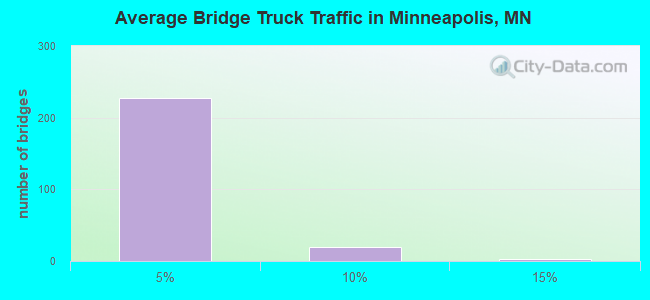
- 21,380,514Total average daily traffic
- 715,072Total average daily truck traffic
- National Bridge Inventory (NBI) Registered Bridges for Minneapolis
- No street view available for this location
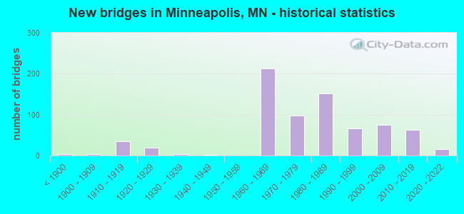
- New bridges - historical statistics
- 3Before 1900
- 41900-1909
- 351910-1919
- 201920-1929
- 41930-1939
- 11940-1949
- 2121960-1969
- 981970-1979
- 1521980-1989
- 671990-1999
- 752000-2009
- 622010-2019
- 152020-2022
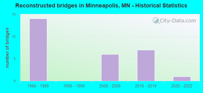
- Reconstructed bridges - Historical Statistics
- 141980-1989
- 01990-1999
- 62000-2009
- 72010-2019
- 12020-2022
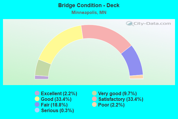
- Bridge Condition - Deck
- 2.2%Excellent
- 9.7%Very good
- 33.4%Good
- 33.4%Satisfactory
- 18.8%Fair
- 2.2%Poor
- 0.3%Serious
- Bridge Condition - Superstructure
- 2.2%Excellent
- 11.4%Very good
- 30.2%Good
- 34.8%Satisfactory
- 18.8%Fair
- 1.5%Poor
- 1.2%Serious
- Bridge Condition - Substructure
- 2.2%Excellent
- 8.9%Very good
- 35.1%Good
- 22.8%Satisfactory
- 26.5%Fair
- 4.3%Poor
- 0.3%Serious
- Bridge Condition - Channel
- 4.2%Excellent
- 38.9%Very good
- 26.4%Good
- 20.8%Satisfactory
- 8.3%Fair
- 1.4%Poor
- Bridge Condition - Culverts
- 5.9%Very good
- 17.6%Good
- 35.3%Satisfactory
- 35.3%Fair
- 5.9%Poor
Find on map >> Show street view
Structure Number: 27798, Location: AT THE JCT TH 394; 94 (Lat: 44.975892, Lng: -93.287778), Route carried "under" structure: Interstate 94, Year Built: 1991, Structure Length: 0. m, Average Daily Traffic: 91,000 (year 2019), Truck Traffic: 4%, Features Intersected: I 94, RAMP; LYNDALE, Facility Carried by Structure: CON 4555
Minimum Vertical Clearance: 5.15m (16.90ft), Kilometerpoint: 0.000, Lanes on structure: 1, Lanes under structure: 5, Material/Design: Prestressed concrete, Design/Construction: Stringer/Multi-beam, Length of Maximum Span: 22.0m (72.2ft)
Find on map >> Show street view
Structure Number: 27799, Location: 0.1 MI S OF JCT TH 394 (Lat: 44.971928, Lng: -93.287453), Route carried "under" structure: City street 312, Year Built: 1968, Structure Length: 0. m, Average Daily Traffic: 14,100 (year 2005), Features Intersected: Dunwoody Blvd, Facility Carried by Structure: I 94
Minimum Vertical Clearance: 4.88m (16.01ft), Kilometerpoint: 0.000, Lanes on structure: 6, Lanes under structure: 6, Material/Design: Prestressed concrete, Design/Construction: Stringer/Multi-beam, Length of Maximum Span: 18.7m (61.4ft)
Find on map >> Show street view
Structure Number: 27799L, Location: 0.1 MI S OF JCT TH 394 (Lat: 44.972461, Lng: -93.287156), Route carried "under" structure: City street 312, Year Built: 1968, Structure Length: 0. m, Average Daily Traffic: 14,100 (year 2005), Features Intersected: Lyndale Avenue NB, Facility Carried by Structure: CON 6593
Minimum Vertical Clearance: 4.82m (15.81ft), Kilometerpoint: 0.000, Lanes on structure: 2, Lanes under structure: 6, Material/Design: Prestressed concrete, Design/Construction: Stringer/Multi-beam, Length of Maximum Span: 19.5m (64.0ft)
Find on map >> Show street view
Structure Number: 27799R, Location: 0.1 MI S OF JCT TH 394 (Lat: 44.972636, Lng: -93.287811), Route carried "under" structure: City street 312, Year Built: 1969, Structure Length: 0. m, Average Daily Traffic: 14,100 (year 2005), Features Intersected: Lyndale Avenue SB, Facility Carried by Structure: CON 2224
Minimum Vertical Clearance: 4.66m (15.29ft), Kilometerpoint: 0.000, Lanes on structure: 2, Lanes under structure: 6, Material/Design: Steel continuous, Design/Construction: Stringer/Multi-beam, Length of Maximum Span: 32.0m (105.0ft)
Find on map >> Show street view
Structure Number: 27799R, Location: 0.1 MI S OF JCT TH 394 (Lat: 44.972636, Lng: -93.287811), Route carried "under" structure: City street 1964, Year Built: 1969, Structure Length: 0. m, Average Daily Traffic: 17,500 (year 1997), Features Intersected: Lyndale Avenue SB, Facility Carried by Structure: CON 2224
Minimum Vertical Clearance: 4.60m (15.09ft), Kilometerpoint: 0.000, Lanes on structure: 2, Lanes under structure: 3, Material/Design: Steel continuous, Design/Construction: Stringer/Multi-beam, Length of Maximum Span: 32.0m (105.0ft)
Find on map >> Show street view
Structure Number: 27807, Location: 1.3 MI S OF JCT TH 694 (Lat: 45.051156, Lng: -93.285156), Route carried "under" structure: Interstate 94, Year Built: 1979, Structure Length: 0. m, Average Daily Traffic: 99,000 (year 2019), Truck Traffic: 4%, Features Intersected: I 94, Facility Carried by Structure: MSAS 113
Minimum Vertical Clearance: 5.30m (17.39ft), Kilometerpoint: 0.000, Lanes on structure: 4, Lanes under structure: 8, Material/Design: Steel continuous, Design/Construction: Stringer/Multi-beam, Length of Maximum Span: 29.7m (97.4ft)
Find on map >> Show street view
Structure Number: 27808, Location: 2.0 MI S OF JCT TH 694 (Lat: 45.043953, Lng: -93.284653), Route carried "under" structure: Ramp Interstate 5782, Year Built: 1982, Structure Length: 0. m, Average Daily Traffic: 2,000 (year 1994), Features Intersected: I 94, BUS RAMP; ON RAMP, Facility Carried by Structure: MSAS 263
Minimum Vertical Clearance: 5.40m (17.72ft), Kilometerpoint: 0.000, Lanes on structure: 4, Lanes under structure: 1, Material/Design: Steel continuous, Design/Construction: Stringer/Multi-beam, Length of Maximum Span: 31.4m (103.0ft)
Find on map >> Show street view
Structure Number: 27808, Location: 2.0 MI S OF JCT TH 694 (Lat: 45.043953, Lng: -93.284653), Route carried "under" structure: Interstate 94, Year Built: 1982, Structure Length: 0. m, Average Daily Traffic: 99,000 (year 2019), Truck Traffic: 4%, Features Intersected: I 94, BUS RAMP; ON RAMP, Facility Carried by Structure: MSAS 263
Minimum Vertical Clearance: 5.49m (18.01ft), Kilometerpoint: 0.000, Lanes on structure: 4, Lanes under structure: 8, Material/Design: Steel continuous, Design/Construction: Stringer/Multi-beam, Length of Maximum Span: 31.4m (103.0ft)
Find on map >> Show street view
Structure Number: 27808, Location: 2.0 MI S OF JCT TH 694 (Lat: 45.043953, Lng: -93.284653), Route carried "under" structure: Ramp Interstate 5782, Year Built: 1982, Structure Length: 0. m, Average Daily Traffic: 4,250 (year 1994), Features Intersected: I 94, BUS RAMP; ON RAMP, Facility Carried by Structure: MSAS 263
Minimum Vertical Clearance: 4.91m (16.11ft), Kilometerpoint: 0.000, Lanes on structure: 4, Lanes under structure: 1, Material/Design: Steel continuous, Design/Construction: Stringer/Multi-beam, Length of Maximum Span: 31.4m (103.0ft)
Find on map >> Show street view
Structure Number: 27812, Location: 3.4 MI N OF JCT TH 12 (Lat: 45.023933, Lng: -93.284517), Route carried "under" structure: Interstate 94, Year Built: 1977, Structure Length: 0. m, Average Daily Traffic: 111,000 (year 2019), Truck Traffic: 4%, Features Intersected: I 94, Facility Carried by Structure: MSAS 169
Minimum Vertical Clearance: 7.13m (23.39ft), Kilometerpoint: 0.000, Lanes on structure: 4, Lanes under structure: 8, Material/Design: Prestressed concrete, Design/Construction: Stringer/Multi-beam, Length of Maximum Span: 33.7m (110.6ft)
Find on map >> Show street view
Structure Number: 27813, Location: 2.7 MI N OF JCT TH 12 (Lat: 45.013111, Lng: -93.282578), Route carried "under" structure: Interstate 94, Year Built: 1977, Structure Length: 0. m, Average Daily Traffic: 112,000 (year 2019), Truck Traffic: 4%, Features Intersected: I 94, Facility Carried by Structure: CSAH 153
Minimum Vertical Clearance: 8.02m (26.31ft), Kilometerpoint: 0.000, Lanes on structure: 4, Lanes under structure: 10, Material/Design: Prestressed concrete, Design/Construction: Stringer/Multi-beam, Length of Maximum Span: 31.9m (104.7ft)
Find on map >> Show street view
Structure Number: 27814, Location: 2.2 MI N OF JCT TH 12 (Lat: 45.005883, Lng: -93.282631), Route carried "under" structure: Interstate 94, Year Built: 1977, Structure Length: 0. m, Average Daily Traffic: 112,000 (year 2019), Truck Traffic: 4%, Features Intersected: I 94, Facility Carried by Structure: MSAS 240
Minimum Vertical Clearance: 5.09m (16.70ft), Kilometerpoint: 0.000, Lanes on structure: 2, Lanes under structure: 10, Material/Design: Steel continuous, Design/Construction: Stringer/Multi-beam, Length of Maximum Span: 32.1m (105.3ft)
Find on map >> Show street view
Structure Number: 27815, Location: 1.8 MI N OF JCT TH 394 (Lat: 44.999172, Lng: -93.282853), Route carried "under" structure: Interstate 94, Year Built: 1978, Structure Length: 0. m, Average Daily Traffic: 91,000 (year 2019), Truck Traffic: 4%, Features Intersected: I 94; US 952A, Facility Carried by Structure: CSAH 81
Minimum Vertical Clearance: 5.46m (17.91ft), Kilometerpoint: 0.000, Lanes on structure: 6, Lanes under structure: 8, Material/Design: Steel continuous, Design/Construction: Stringer/Multi-beam, Length of Maximum Span: 28.9m (94.8ft)
Find on map >> Show street view
Structure Number: 27815, Location: 1.8 MI N OF JCT TH 394 (Lat: 44.999172, Lng: -93.282853), Route carried "under" structure: US 52, Year Built: 1978, Structure Length: 0. m, Average Daily Traffic: 17,000 (year 1996), Truck Traffic: 5%, Features Intersected: I 94; US 952A, Facility Carried by Structure: CSAH 81
Minimum Vertical Clearance: 5.43m (17.81ft), Kilometerpoint: 0.000, Lanes on structure: 6, Lanes under structure: 2, Material/Design: Steel continuous, Design/Construction: Stringer/Multi-beam, Length of Maximum Span: 28.9m (94.8ft)
Find on map >> Show street view
Structure Number: 27815, Location: 1.8 MI N OF JCT TH 394 (Lat: 44.999172, Lng: -93.282853), Route carried "under" structure: US 52, Year Built: 1978, Structure Length: 0. m, Average Daily Traffic: 17,000 (year 1996), Truck Traffic: 5%, Features Intersected: I 94; US 952A, Facility Carried by Structure: CSAH 81
Minimum Vertical Clearance: 5.09m (16.70ft), Kilometerpoint: 0.000, Lanes on structure: 6, Lanes under structure: 2, Material/Design: Steel continuous, Design/Construction: Stringer/Multi-beam, Length of Maximum Span: 28.9m (94.8ft)
Find on map >> Show street view
Structure Number: 27816N, Location: 0.3 MI SE OF JCT TH 94 (Lat: 44.985894, Lng: -93.279350), Route carried "under" structure: City street 599, Year Built: 1982, Structure Length: 0. m, Average Daily Traffic: 1,000 (year 1979), Features Intersected: RR; STREETS TO I 94, Facility Carried by Structure: UNU 52
Minimum Vertical Clearance: 5.00m (16.40ft), Kilometerpoint: 0.000, Lanes on structure: 2, Lanes under structure: 4, Material/Design: Prestressed concrete, Design/Construction: Stringer/Multi-beam, Length of Maximum Span: 38.1m (125.0ft)
Find on map >> Show street view
Structure Number: 27816N, Location: 0.3 MI SE OF JCT TH 94 (Lat: 44.985894, Lng: -93.279350), Route carried "under" structure: City street 209, Year Built: 1982, Structure Length: 0. m, Average Daily Traffic: 4,300 (year 2005), Features Intersected: RR; STREETS TO I 94, Facility Carried by Structure: UNU 52
Minimum Vertical Clearance: 4.54m (14.90ft), Kilometerpoint: 0.000, Lanes on structure: 2, Lanes under structure: 4, Material/Design: Prestressed concrete, Design/Construction: Stringer/Multi-beam, Length of Maximum Span: 38.1m (125.0ft)
Find on map >> Show street view
Structure Number: 27816N, Location: 0.3 MI SE OF JCT TH 94 (Lat: 44.985894, Lng: -93.279350), Route carried "under" structure: City street 194, Year Built: 1982, Structure Length: 0. m, Average Daily Traffic: 4,500 (year 2005), Features Intersected: RR; STREETS TO I 94, Facility Carried by Structure: UNU 52
Minimum Vertical Clearance: 4.97m (16.31ft), Kilometerpoint: 0.000, Lanes on structure: 2, Lanes under structure: 4, Material/Design: Prestressed concrete, Design/Construction: Stringer/Multi-beam, Length of Maximum Span: 38.1m (125.0ft)
Find on map >> Show street view
Structure Number: 27816N, Location: 0.3 MI SE OF JCT TH 94 (Lat: 44.985894, Lng: -93.279350), Route carried "under" structure: Other road , Year Built: 1982, Structure Length: 0. m, Average Daily Traffic: 50 (year 1994), Features Intersected: RR; STREETS TO I 94, Facility Carried by Structure: UNU 52
Minimum Vertical Clearance: 4.97m (16.31ft), Kilometerpoint: 0.000, Lanes on structure: 2, Lanes under structure: 1, Material/Design: Prestressed concrete, Design/Construction: Stringer/Multi-beam, Length of Maximum Span: 38.1m (125.0ft)
Find on map >> Show street view
Structure Number: 27816N, Location: 0.3 MI SE OF JCT TH 94 (Lat: 44.985894, Lng: -93.279350), Route carried "under" structure: Ramp US 4897, Year Built: 1982, Structure Length: 0. m, Average Daily Traffic: 3,000 (year 1994), Features Intersected: RR; STREETS TO I 94, Facility Carried by Structure: UNU 52
Minimum Vertical Clearance: 6.80m (22.31ft), Kilometerpoint: 0.000, Lanes on structure: 2, Lanes under structure: 2, Material/Design: Prestressed concrete, Design/Construction: Stringer/Multi-beam, Length of Maximum Span: 38.1m (125.0ft)
Find on map >> Show street view
Structure Number: 27816N, Location: 0.3 MI SE OF JCT TH 94 (Lat: 44.985894, Lng: -93.279350), Route carried "under" structure: Interstate 394, Year Built: 1982, Structure Length: 0. m, Average Daily Traffic: 36,500 (year 2019), Truck Traffic: 4%, Features Intersected: RR; STREETS TO I 94, Facility Carried by Structure: UNU 52
Minimum Vertical Clearance: 4.97m (16.31ft), Kilometerpoint: 0.000, Lanes on structure: 2, Lanes under structure: 1, Material/Design: Prestressed concrete, Design/Construction: Stringer/Multi-beam, Length of Maximum Span: 38.1m (125.0ft)
Find on map >> Show street view
Structure Number: 27816N, Location: 0.3 MI SE OF JCT TH 94 (Lat: 44.985894, Lng: -93.279350), Route carried "under" structure: City street 220, Year Built: 1982, Structure Length: 0. m, Average Daily Traffic: 2,400 (year 2005), Features Intersected: RR; STREETS TO I 94, Facility Carried by Structure: UNU 52
Minimum Vertical Clearance: 5.85m (19.19ft), Kilometerpoint: 0.000, Lanes on structure: 2, Lanes under structure: 4, Material/Design: Prestressed concrete, Design/Construction: Stringer/Multi-beam, Length of Maximum Span: 38.1m (125.0ft)
Find on map >> Show street view
Structure Number: 27816S, Location: 0.3 MI SE OF JCT TH 94 (Lat: 44.986075, Lng: -93.279983), Route carried "under" structure: Ramp US 4897, Year Built: 1982, Structure Length: 0. m, Average Daily Traffic: 3,000 (year 1994), Features Intersected: I 94 ramp RR, streets, Facility Carried by Structure: UNU 52
Minimum Vertical Clearance: 5.09m (16.70ft), Kilometerpoint: 0.000, Lanes on structure: 2, Lanes under structure: 1, Material/Design: Prestressed concrete, Design/Construction: Stringer/Multi-beam, Length of Maximum Span: 35.4m (116.1ft)
Find on map >> Show street view
Structure Number: 27816S, Location: 0.3 MI SE OF JCT TH 94 (Lat: 44.986075, Lng: -93.279983), Route carried "under" structure: Ramp US 1812, Year Built: 1982, Structure Length: 0. m, Average Daily Traffic: 3,000 (year 1994), Features Intersected: I 94 ramp RR, streets, Facility Carried by Structure: UNU 52
Minimum Vertical Clearance: 7.01m (23.00ft), Kilometerpoint: 0.000, Lanes on structure: 2, Lanes under structure: 1, Material/Design: Prestressed concrete, Design/Construction: Stringer/Multi-beam, Length of Maximum Span: 35.4m (116.1ft)
Find on map >> Show street view
Structure Number: 27816S, Location: 0.3 MI SE OF JCT TH 94 (Lat: 44.986075, Lng: -93.279983), Route carried "under" structure: Interstate 394, Year Built: 1982, Structure Length: 0. m, Average Daily Traffic: 36,500 (year 2019), Truck Traffic: 4%, Features Intersected: I 94 ramp RR, streets, Facility Carried by Structure: UNU 52
Minimum Vertical Clearance: 5.09m (16.70ft), Kilometerpoint: 0.000, Lanes on structure: 2, Lanes under structure: 2, Material/Design: Prestressed concrete, Design/Construction: Stringer/Multi-beam, Length of Maximum Span: 35.4m (116.1ft)
Find on map >> Show street view
Structure Number: 27816S, Location: 0.3 MI SE OF JCT TH 94 (Lat: 44.986075, Lng: -93.279983), Route carried "under" structure: City street 209, Year Built: 1982, Structure Length: 0. m, Average Daily Traffic: 4,300 (year 2005), Features Intersected: I 94 ramp RR, streets, Facility Carried by Structure: UNU 52
Minimum Vertical Clearance: 4.60m (15.09ft), Kilometerpoint: 0.000, Lanes on structure: 2, Lanes under structure: 4, Material/Design: Prestressed concrete, Design/Construction: Stringer/Multi-beam, Length of Maximum Span: 35.4m (116.1ft)
Find on map >> Show street view
Structure Number: 27816S, Location: 0.3 MI SE OF JCT TH 94 (Lat: 44.986075, Lng: -93.279983), Route carried "under" structure: City street 599, Year Built: 1982, Structure Length: 0. m, Average Daily Traffic: 1,000 (year 1979), Features Intersected: I 94 ramp RR, streets, Facility Carried by Structure: UNU 52
Minimum Vertical Clearance: 6.16m (20.21ft), Kilometerpoint: 0.000, Lanes on structure: 2, Lanes under structure: 4, Material/Design: Prestressed concrete, Design/Construction: Stringer/Multi-beam, Length of Maximum Span: 35.4m (116.1ft)
Find on map >> Show street view
Structure Number: 27816S, Location: 0.3 MI SE OF JCT TH 94 (Lat: 44.986075, Lng: -93.279983), Route carried "under" structure: City street 194, Year Built: 1982, Structure Length: 0. m, Average Daily Traffic: 4,500 (year 2005), Features Intersected: I 94 ramp RR, streets, Facility Carried by Structure: UNU 52
Minimum Vertical Clearance: 5.79m (19.00ft), Kilometerpoint: 0.000, Lanes on structure: 2, Lanes under structure: 4, Material/Design: Prestressed concrete, Design/Construction: Stringer/Multi-beam, Length of Maximum Span: 35.4m (116.1ft)
Find on map >> Show street view
Structure Number: 27816S, Location: 0.3 MI SE OF JCT TH 94 (Lat: 44.986075, Lng: -93.279983), Route carried "under" structure: Ramp US 1034, Year Built: 1982, Structure Length: 0. m, Average Daily Traffic: 50 (year 1994), Features Intersected: I 94 ramp RR, streets, Facility Carried by Structure: UNU 52
Minimum Vertical Clearance: 5.09m (16.70ft), Kilometerpoint: 0.000, Lanes on structure: 2, Lanes under structure: 2, Material/Design: Prestressed concrete, Design/Construction: Stringer/Multi-beam, Length of Maximum Span: 35.4m (116.1ft)
Find on map >> Show street view
Structure Number: 27816S, Location: 0.3 MI SE OF JCT TH 94 (Lat: 44.986075, Lng: -93.279983), Route carried "under" structure: City street 220, Year Built: 1982, Structure Length: 0. m, Average Daily Traffic: 2,400 (year 2005), Features Intersected: I 94 ramp RR, streets, Facility Carried by Structure: UNU 52
Minimum Vertical Clearance: 6.65m (21.82ft), Kilometerpoint: 0.000, Lanes on structure: 2, Lanes under structure: 4, Material/Design: Prestressed concrete, Design/Construction: Stringer/Multi-beam, Length of Maximum Span: 35.4m (116.1ft)
Find on map >> Show street view
Structure Number: 27817, Location: 1.6 MI N OF JCT TH 394 (Lat: 44.997842, Lng: -93.283511), Route carried "under" structure: US 52, Year Built: 1980, Structure Length: 0. m, Average Daily Traffic: 20,000 (year 2006), Truck Traffic: 5%, Features Intersected: SB off ramp, Facility Carried by Structure: CON 234
Minimum Vertical Clearance: 5.46m (17.91ft), Kilometerpoint: 0.000, Lanes on structure: 2, Lanes under structure: 2, Material/Design: Steel continuous, Design/Construction: Stringer/Multi-beam, Length of Maximum Span: 46.2m (151.6ft)
Find on map >> Show street view
Structure Number: 27818, Location: 1.4 MI N OF JCT TH 394 (Lat: 44.996264, Lng: -93.282197), Route carried "under" structure: US 52, Year Built: 1980, Structure Length: 0. m, Average Daily Traffic: 9,000 (year 2019), Truck Traffic: 4%, Features Intersected: NB on ramp, Facility Carried by Structure: CON 4512
Minimum Vertical Clearance: 5.24m (17.19ft), Kilometerpoint: 0.000, Lanes on structure: 3, Lanes under structure: 2, Material/Design: Steel, Design/Construction: Stringer/Multi-beam, Length of Maximum Span: 33.0m (108.3ft)
Find on map >> Show street view
Structure Number: 27819, Location: 2.9 MI S OF JCT TH 694 (Lat: 45.029400, Lng: -93.286942), Route carried "under" structure: Interstate 94, Year Built: 1980, Structure Length: 0. m, Average Daily Traffic: 111,000 (year 2019), Truck Traffic: 4%, Features Intersected: I 94, Facility Carried by Structure: CSAH 152
Minimum Vertical Clearance: 7.13m (23.39ft), Kilometerpoint: 0.000, Lanes on structure: 4, Lanes under structure: 8, Material/Design: Steel continuous, Design/Construction: Stringer/Multi-beam, Length of Maximum Span: 29.0m (95.1ft)
Find on map >> Show street view
Structure Number: 27821, Location: 2.7 MI S OF JCT TH 694 (Lat: 45.032139, Lng: -93.287422), Route carried "under" structure: Interstate 94, Year Built: 1982, Structure Length: 0. m, Average Daily Traffic: 111,000 (year 2019), Truck Traffic: 4%, Features Intersected: I 94, Facility Carried by Structure: RAILROAD
Minimum Vertical Clearance: 5.49m (18.01ft), Kilometerpoint: 0.000, Lanes on structure: 8, Lanes under structure: 8, Material/Design: Steel, Design/Construction: Girder and Floorbeam System, Length of Maximum Span: 44.6m (146.3ft)
Find on map >> Show street view
Structure Number: 27822, Location: 1.5 MI S OF JCT I-94 (Lat: 44.946700, Lng: -93.274700), Route carried "under" structure: City street 366, Year Built: 2021, Structure Length: 0. m, Average Daily Traffic: 9,900 (year 2019), Features Intersected: E 31ST ST, Facility Carried by Structure: I 35W NB
Minimum Vertical Clearance: 5.27m (17.29ft), Kilometerpoint: 0.000, Lanes under structure: 4, Material/Design: Prestressed concrete, Design/Construction: Stringer/Multi-beam, Length of Maximum Span: 28.3m (92.8ft)
Find on map >> Show street view
Structure Number: 27831, Location: 0.5 Mi west of Jct TH 94 (Lat: 44.972644, Lng: -93.294503), Route carried "under" structure: City street 312, Year Built: 1967, Structure Length: 0. m, Average Daily Traffic: 14,100 (year 2005), Features Intersected: Dunwoody Blvd, Facility Carried by Structure: I 394
Minimum Vertical Clearance: 5.61m (18.41ft), Kilometerpoint: 0.000, Lanes on structure: 6, Lanes under structure: 3, Material/Design: Prestressed concrete, Design/Construction: Stringer/Multi-beam, Length of Maximum Span: 19.8m (65.0ft)
Find on map >> Show street view
Structure Number: 27834, Location: AT THE W JCT TH 35; 94 (Lat: 44.965492, Lng: -93.267936), Route carried "under" structure: Interstate 94, Year Built: 1967, Structure Length: 0. m, Average Daily Traffic: 72,645 (year 2019), Truck Traffic: 4%, Features Intersected: I 94 EB, Facility Carried by Structure: I 35W
Minimum Vertical Clearance: 4.60m (15.09ft), Kilometerpoint: 0.000, Lanes on structure: 3, Lanes under structure: 3, Material/Design: Concrete, Design/Construction: Frame, Length of Maximum Span: 18.3m (60.0ft)
Find on map >> Show street view
Structure Number: 27836, Location: 0.5 MI W OF W JCT TH 35W (Lat: 44.965800, Lng: -93.279342), Route carried "under" structure: Interstate 94, Year Built: 1964, Structure Length: 0. m, Average Daily Traffic: 154,000 (year 2019), Truck Traffic: 4%, Features Intersected: I 94, Facility Carried by Structure: MSAS 159
Minimum Vertical Clearance: 4.66m (15.29ft), Kilometerpoint: 0.000, Lanes on structure: 2, Lanes under structure: 8, Material/Design: Prestressed concrete, Design/Construction: Stringer/Multi-beam, Length of Maximum Span: 23.7m (77.8ft)
Find on map >> Show street view
Structure Number: 27837, Location: 0.4 MI W OF W JCT TH 35W (Lat: 44.966250, Lng: -93.277817), Route carried "under" structure: Interstate 94, Year Built: 1966, Structure Length: 0. m, Average Daily Traffic: 154,000 (year 2019), Truck Traffic: 4%, Features Intersected: I 94, Facility Carried by Structure: MSAS 283
Minimum Vertical Clearance: 4.57m (14.99ft), Kilometerpoint: 0.000, Lanes on structure: 4, Lanes under structure: 8, Material/Design: Prestressed concrete, Design/Construction: Stringer/Multi-beam, Length of Maximum Span: 23.7m (77.8ft)
Find on map >> Show street view
Structure Number: 27838, Location: 0.3 MI W OF W JCT TH 35W (Lat: 44.966564, Lng: -93.276528), Route carried "under" structure: Interstate 94, Year Built: 1965, Structure Length: 0. m, Average Daily Traffic: 154,000 (year 2019), Truck Traffic: 4%, Features Intersected: I 94, Facility Carried by Structure: MSAS 190
Minimum Vertical Clearance: 4.51m (14.80ft), Kilometerpoint: 0.000, Lanes on structure: 2, Lanes under structure: 8, Material/Design: Prestressed concrete, Design/Construction: Stringer/Multi-beam, Length of Maximum Span: 27.7m (90.9ft)
Find on map >> Show street view
Structure Number: 2784, Location: ATH THE JCT TH 65; 94 (Lat: 44.968033, Lng: -93.269692), Route carried "under" structure: Ramp Interstate 334, Year Built: 1966, Structure Length: 0. m, Average Daily Traffic: 7,000 (year 1994), Features Intersected: TH 65; RAMPS, Facility Carried by Structure: MSAS 281
Minimum Vertical Clearance: 4.54m (14.90ft), Kilometerpoint: 0.000, Lanes on structure: 4, Lanes under structure: 1, Material/Design: Prestressed concrete, Design/Construction: Stringer/Multi-beam, Length of Maximum Span: 23.5m (77.1ft)
Find on map >> Show street view
Structure Number: 2784, Location: ATH THE JCT TH 65; 94 (Lat: 44.968033, Lng: -93.269692), Route carried "under" structure: State highway 65, Year Built: 1966, Structure Length: 0. m, Average Daily Traffic: 55 (year 2019), Truck Traffic: 9%, Features Intersected: TH 65; RAMPS, Facility Carried by Structure: MSAS 281
Minimum Vertical Clearance: 4.57m (14.99ft), Kilometerpoint: 0.000, Lanes on structure: 4, Lanes under structure: 6, Material/Design: Prestressed concrete, Design/Construction: Stringer/Multi-beam, Length of Maximum Span: 23.5m (77.1ft)
Find on map >> Show street view
Structure Number: 2784, Location: ATH THE JCT TH 65; 94 (Lat: 44.968033, Lng: -93.269692), Route carried "under" structure: Ramp State highway 2721, Year Built: 1966, Structure Length: 0. m, Average Daily Traffic: 7,000 (year 1994), Features Intersected: TH 65; RAMPS, Facility Carried by Structure: MSAS 281
Minimum Vertical Clearance: 4.54m (14.90ft), Kilometerpoint: 0.000, Lanes on structure: 4, Lanes under structure: 1, Material/Design: Prestressed concrete, Design/Construction: Stringer/Multi-beam, Length of Maximum Span: 23.5m (77.1ft)
Find on map >> Show street view
Structure Number: 27841, Location: 1.4 MI S OF JCT TH 94 (Lat: 44.948375, Lng: -93.274894), Route carried "under" structure: County highway 3, Year Built: 2019, Structure Length: 0. m, Average Daily Traffic: 23,600 (year 2005), Truck Traffic: 1%, Features Intersected: E. LAKE ST
Minimum Vertical Clearance: 5.12m (16.80ft), Kilometerpoint: 0.000, Lanes under structure: 6, Material/Design: Prestressed concrete, Design/Construction: Stringer/Multi-beam, Length of Maximum Span: 42.7m (140.1ft)
Find on map >> Show street view
Structure Number: 27844, Location: 1.4 MI S OF JCT I 94 (Lat: 44.948394, Lng: -93.274603), Route carried "under" structure: County highway 3, Year Built: 2021, Structure Length: 0. m, Average Daily Traffic: 20,200 (year 2011), Truck Traffic: 1%, Features Intersected: E. LAKE ST
Minimum Vertical Clearance: 5.09m (16.70ft), Kilometerpoint: 0.000, Lanes under structure: 6, Material/Design: Prestressed concrete, Design/Construction: Stringer/Multi-beam, Length of Maximum Span: 42.7m (140.1ft)
Find on map >> Show street view
Structure Number: 27845, Location: 1.3 MI S OF JCT I 94 (Lat: 44.948400, Lng: -93.274800), Route carried "under" structure: County highway 3, Year Built: 2021, Structure Length: 0. m, Average Daily Traffic: 19,100 (year 2019), Features Intersected: E LAKE ST, Facility Carried by Structure: BUS RAPID TRANSIT
Minimum Vertical Clearance: 7.89m (25.89ft), Kilometerpoint: 0.000, Lanes under structure: 6, Material/Design: Prestressed concrete, Design/Construction: Box Beam or Girders - Multiple, Length of Maximum Span: 45.7m (149.9ft)
Find on map >> Show street view
Structure Number: 27848, Location: AT THE E JCT TH 94; 35W (Lat: 44.966139, Lng: -93.255586), Route carried "under" structure: Interstate 35W, Year Built: 1967, Structure Length: 0. m, Average Daily Traffic: 114,000 (year 2019), Truck Traffic: 4%, Features Intersected: I 35W; SB on ramp, Facility Carried by Structure: I 94
Minimum Vertical Clearance: 6.77m (22.21ft), Kilometerpoint: 0.000, Lanes on structure: 4, Lanes under structure: 5, Material/Design: Steel continuous, Design/Construction: Stringer/Multi-beam, Length of Maximum Span: 29.1m (95.5ft)
Find on map >> Show street view
Structure Number: 27848, Location: AT THE E JCT TH 94; 35W (Lat: 44.966139, Lng: -93.255586), Route carried "under" structure: Ramp Interstate 1573, Year Built: 1967, Structure Length: 0. m, Average Daily Traffic: 10,000 (year 1994), Features Intersected: I 35W; SB on ramp, Facility Carried by Structure: I 94
Minimum Vertical Clearance: 4.63m (15.19ft), Kilometerpoint: 0.000, Lanes on structure: 4, Lanes under structure: 2, Material/Design: Steel continuous, Design/Construction: Stringer/Multi-beam, Length of Maximum Span: 29.1m (95.5ft)
Find on map >> Show street view
Structure Number: 27849, Location: AT JCT TH 55; 35W (Lat: 44.967608, Lng: -93.253783), Route carried "under" structure: Interstate 35W, Year Built: 1967, Structure Length: 0. m, Average Daily Traffic: 114,000 (year 2019), Truck Traffic: 4%, Features Intersected: I 35W; RAMPS, Facility Carried by Structure: MN 55
Minimum Vertical Clearance: 7.74m (25.39ft), Kilometerpoint: 0.000, Lanes on structure: 2, Lanes under structure: 4, Material/Design: Steel continuous, Design/Construction: Stringer/Multi-beam, Length of Maximum Span: 23.9m (78.4ft)
Find on map >> Show street view
Structure Number: 27849, Location: AT JCT TH 55; 35W (Lat: 44.967608, Lng: -93.253783), Route carried "under" structure: Ramp State highway 5483, Year Built: 1967, Structure Length: 0. m, Average Daily Traffic: 8,300 (year 1994), Features Intersected: I 35W; RAMPS, Facility Carried by Structure: MN 55
Minimum Vertical Clearance: 4.69m (15.39ft), Kilometerpoint: 0.000, Lanes on structure: 2, Lanes under structure: 2, Material/Design: Steel continuous, Design/Construction: Stringer/Multi-beam, Length of Maximum Span: 23.9m (78.4ft)
Find on map >> Show street view
Structure Number: 27849, Location: AT JCT TH 55; 35W (Lat: 44.967608, Lng: -93.253783), Route carried "under" structure: Ramp State highway 576, Year Built: 1967, Structure Length: 0. m, Average Daily Traffic: 10,200 (year 1994), Features Intersected: I 35W; RAMPS, Facility Carried by Structure: MN 55
Minimum Vertical Clearance: 7.22m (23.69ft), Kilometerpoint: 0.000, Lanes on structure: 2, Lanes under structure: 2, Material/Design: Steel continuous, Design/Construction: Stringer/Multi-beam, Length of Maximum Span: 23.9m (78.4ft)
Find on map >> Show street view
Structure Number: 27849, Location: AT JCT TH 55; 35W (Lat: 44.967608, Lng: -93.253783), Route carried "under" structure: Ramp State highway 4341, Year Built: 1967, Structure Length: 0. m, Average Daily Traffic: 10,000 (year 1994), Features Intersected: I 35W; RAMPS, Facility Carried by Structure: MN 55
Minimum Vertical Clearance: 4.69m (15.39ft), Kilometerpoint: 0.000, Lanes on structure: 2, Lanes under structure: 2, Material/Design: Steel continuous, Design/Construction: Stringer/Multi-beam, Length of Maximum Span: 23.9m (78.4ft)
Find on map >> Show street view
Structure Number: 27849, Location: AT JCT TH 55; 35W (Lat: 44.967608, Lng: -93.253783), Route carried "under" structure: Ramp State highway 2373, Year Built: 1967, Structure Length: 0. m, Average Daily Traffic: 8,300 (year 1994), Features Intersected: I 35W; RAMPS, Facility Carried by Structure: MN 55
Minimum Vertical Clearance: 4.60m (15.09ft), Kilometerpoint: 0.000, Lanes on structure: 2, Lanes under structure: 1, Material/Design: Steel continuous, Design/Construction: Stringer/Multi-beam, Length of Maximum Span: 23.9m (78.4ft)
Find on map >> Show street view
Structure Number: 2785, Location: AT THE EAST JCT TH 94 (Lat: 44.966419, Lng: -93.254844), Route carried "under" structure: Ramp Interstate 1573, Year Built: 1967, Structure Length: 0. m, Average Daily Traffic: 10,000 (year 1994), Features Intersected: I 35W; SB ON RAMP, Facility Carried by Structure: CON 1923
Minimum Vertical Clearance: 4.69m (15.39ft), Kilometerpoint: 0.000, Lanes on structure: 2, Lanes under structure: 2, Material/Design: Steel continuous, Design/Construction: Stringer/Multi-beam, Length of Maximum Span: 27.1m (88.9ft)
Find on map >> Show street view
Structure Number: 2785, Location: AT THE EAST JCT TH 94 (Lat: 44.966419, Lng: -93.254844), Route carried "under" structure: Interstate 35W, Year Built: 1967, Structure Length: 0. m, Average Daily Traffic: 114,000 (year 2019), Truck Traffic: 4%, Features Intersected: I 35W; SB ON RAMP, Facility Carried by Structure: CON 1923
Minimum Vertical Clearance: 7.44m (24.41ft), Kilometerpoint: 0.000, Lanes on structure: 2, Lanes under structure: 6, Material/Design: Steel continuous, Design/Construction: Stringer/Multi-beam, Length of Maximum Span: 27.1m (88.9ft)
Find on map >> Show street view
Structure Number: 27851, Location: 0.6 MI WEST OF JCT TH 55 (Lat: 44.965742, Lng: -93.267656), Route carried "under" structure: Ramp Interstate 4222, Year Built: 1967, Structure Length: 0. m, Average Daily Traffic: 4,360 (year 1994), Features Intersected: I 35W; I 94 WB, Facility Carried by Structure: CSAH 35
Minimum Vertical Clearance: 4.57m (14.99ft), Kilometerpoint: 0.000, Lanes on structure: 4, Lanes under structure: 1, Material/Design: Steel continuous, Design/Construction: Stringer/Multi-beam, Length of Maximum Span: 40.8m (133.9ft)
Find on map >> Show street view
Structure Number: 27851, Location: 0.6 MI WEST OF JCT TH 55 (Lat: 44.965742, Lng: -93.267656), Route carried "under" structure: Interstate 94, Year Built: 1967, Structure Length: 0. m, Average Daily Traffic: 145,290 (year 2019), Truck Traffic: 4%, Features Intersected: I 35W; I 94 WB, Facility Carried by Structure: CSAH 35
Minimum Vertical Clearance: 5.06m (16.60ft), Kilometerpoint: 0.000, Lanes on structure: 4, Lanes under structure: 4, Material/Design: Steel continuous, Design/Construction: Stringer/Multi-beam, Length of Maximum Span: 40.8m (133.9ft)
Find on map >> Show street view
Structure Number: 27851, Location: 0.6 MI WEST OF JCT TH 55 (Lat: 44.965742, Lng: -93.267656), Route carried "under" structure: Interstate 35W, Year Built: 1967, Structure Length: 0. m, Average Daily Traffic: 95,000 (year 2019), Truck Traffic: 4%, Features Intersected: I 35W; I 94 WB, Facility Carried by Structure: CSAH 35
Minimum Vertical Clearance: 5.15m (16.90ft), Kilometerpoint: 0.000, Lanes on structure: 4, Lanes under structure: 4, Material/Design: Steel continuous, Design/Construction: Stringer/Multi-beam, Length of Maximum Span: 40.8m (133.9ft)
Find on map >> Show street view
Structure Number: 27851, Location: 0.6 MI WEST OF JCT TH 55 (Lat: 44.965742, Lng: -93.267656), Route carried "under" structure: Ramp Interstate 2792, Year Built: 1967, Structure Length: 0. m, Average Daily Traffic: 3,700 (year 1994), Features Intersected: I 35W; I 94 WB, Facility Carried by Structure: CSAH 35
Minimum Vertical Clearance: 4.57m (14.99ft), Kilometerpoint: 0.000, Lanes on structure: 4, Lanes under structure: 1, Material/Design: Steel continuous, Design/Construction: Stringer/Multi-beam, Length of Maximum Span: 40.8m (133.9ft)
Find on map >> Show street view
Structure Number: 27851, Location: 0.6 MI WEST OF JCT TH 55 (Lat: 44.965742, Lng: -93.267656), Route carried "under" structure: Ramp Interstate 334, Year Built: 1967, Structure Length: 0. m, Average Daily Traffic: 6,100 (year 1994), Features Intersected: I 35W; I 94 WB, Facility Carried by Structure: CSAH 35
Minimum Vertical Clearance: 5.09m (16.70ft), Kilometerpoint: 0.000, Lanes on structure: 4, Lanes under structure: 1, Material/Design: Steel continuous, Design/Construction: Stringer/Multi-beam, Length of Maximum Span: 40.8m (133.9ft)
Find on map >> Show street view
Structure Number: 27852, Location: 0.5 MI WEST OF JCT TH 55 (Lat: 44.965714, Lng: -93.265097), Route carried "under" structure: Interstate 35W, Year Built: 1967, Structure Length: 0. m, Average Daily Traffic: 114,000 (year 2019), Truck Traffic: 4%, Features Intersected: I 35W, I 94; ramp, Facility Carried by Structure: CSAH 33
Minimum Vertical Clearance: 4.57m (14.99ft), Kilometerpoint: 0.000, Lanes on structure: 4, Lanes under structure: 4, Material/Design: Prestressed concrete, Design/Construction: Stringer/Multi-beam, Length of Maximum Span: 24.7m (81.0ft)
Find on map >> Show street view
Structure Number: 27852, Location: 0.5 MI WEST OF JCT TH 55 (Lat: 44.965714, Lng: -93.265097), Route carried "under" structure: Interstate 94, Year Built: 1967, Structure Length: 0. m, Average Daily Traffic: 62,000 (year 2019), Truck Traffic: 4%, Features Intersected: I 35W, I 94; ramp, Facility Carried by Structure: CSAH 33
Minimum Vertical Clearance: 5.33m (17.49ft), Kilometerpoint: 0.000, Lanes on structure: 4, Lanes under structure: 3, Material/Design: Prestressed concrete, Design/Construction: Stringer/Multi-beam, Length of Maximum Span: 24.7m (81.0ft)
Find on map >> Show street view
Structure Number: 27852, Location: 0.5 MI WEST OF JCT TH 55 (Lat: 44.965714, Lng: -93.265097), Route carried "under" structure: Interstate 94, Year Built: 1967, Structure Length: 0. m, Average Daily Traffic: 78,500 (year 2004), Truck Traffic: 4%, Features Intersected: I 35W, I 94; ramp, Facility Carried by Structure: CSAH 33
Minimum Vertical Clearance: 4.69m (15.39ft), Kilometerpoint: 0.000, Lanes on structure: 4, Lanes under structure: 4, Material/Design: Prestressed concrete, Design/Construction: Stringer/Multi-beam, Length of Maximum Span: 24.7m (81.0ft)
Find on map >> Show street view
Structure Number: 27852, Location: 0.5 MI WEST OF JCT TH 55 (Lat: 44.965714, Lng: -93.265097), Route carried "under" structure: Ramp Interstate 2792, Year Built: 1967, Structure Length: 0. m, Average Daily Traffic: 3,700 (year 1994), Features Intersected: I 35W, I 94; ramp, Facility Carried by Structure: CSAH 33
Minimum Vertical Clearance: 5.00m (16.40ft), Kilometerpoint: 0.000, Lanes on structure: 4, Lanes under structure: 1, Material/Design: Prestressed concrete, Design/Construction: Stringer/Multi-beam, Length of Maximum Span: 24.7m (81.0ft)
Find on map >> Show street view
Structure Number: 27852, Location: 0.5 MI WEST OF JCT TH 55 (Lat: 44.965714, Lng: -93.265097), Route carried "under" structure: Ramp Interstate 3332, Year Built: 1967, Structure Length: 0. m, Average Daily Traffic: 1 (year 2022), Features Intersected: I 35W, I 94; ramp, Facility Carried by Structure: CSAH 33
Minimum Vertical Clearance: 5.03m (16.50ft), Kilometerpoint: 0.000, Lanes under structure: 1, Material/Design: Prestressed concrete, Design/Construction: Stringer/Multi-beam, Length of Maximum Span: 24.7m (81.0ft)
Find on map >> Show street view
Structure Number: 27853, Location: 0.4 MI WEST OF JCT TH 55 (Lat: 44.965686, Lng: -93.262567), Route carried "under" structure: Interstate 94, Year Built: 1967, Structure Length: 0. m, Average Daily Traffic: 62,000 (year 2019), Truck Traffic: 4%, Features Intersected: I 35W; I 94, Facility Carried by Structure: MSAS 165
Minimum Vertical Clearance: 4.45m (14.60ft), Kilometerpoint: 0.000, Lanes on structure: 4, Lanes under structure: 4, Material/Design: Prestressed concrete, Design/Construction: Stringer/Multi-beam, Length of Maximum Span: 27.7m (90.9ft)
Find on map >> Show street view
Structure Number: 27853, Location: 0.4 MI WEST OF JCT TH 55 (Lat: 44.965686, Lng: -93.262567), Route carried "under" structure: Interstate 35W, Year Built: 1967, Structure Length: 0. m, Average Daily Traffic: 114,000 (year 2019), Truck Traffic: 4%, Features Intersected: I 35W; I 94, Facility Carried by Structure: MSAS 165
Minimum Vertical Clearance: 4.72m (15.49ft), Kilometerpoint: 0.000, Lanes on structure: 4, Lanes under structure: 4, Material/Design: Prestressed concrete, Design/Construction: Stringer/Multi-beam, Length of Maximum Span: 27.7m (90.9ft)
Find on map >> Show street view
Structure Number: 27853, Location: 0.4 MI WEST OF JCT TH 55 (Lat: 44.965686, Lng: -93.262567), Route carried "under" structure: Interstate 94, Year Built: 1967, Structure Length: 0. m, Average Daily Traffic: 78,500 (year 2004), Truck Traffic: 4%, Features Intersected: I 35W; I 94, Facility Carried by Structure: MSAS 165
Minimum Vertical Clearance: 4.48m (14.70ft), Kilometerpoint: 0.000, Lanes on structure: 4, Lanes under structure: 4, Material/Design: Prestressed concrete, Design/Construction: Stringer/Multi-beam, Length of Maximum Span: 27.7m (90.9ft)
Find on map >> Show street view
Structure Number: 27854, Location: 0.3 MI WEST OF JCT TH 55 (Lat: 44.965881, Lng: -93.258178), Route carried "under" structure: Interstate 94, Year Built: 1965, Structure Length: 0. m, Average Daily Traffic: 124,000 (year 2019), Truck Traffic: 4%, Features Intersected: I 35W, I 94; WB ON RAMP, Facility Carried by Structure: MSAS 213
Minimum Vertical Clearance: 4.51m (14.80ft), Kilometerpoint: 0.000, Lanes on structure: 4, Lanes under structure: 4, Material/Design: Prestressed concrete, Design/Construction: Stringer/Multi-beam, Length of Maximum Span: 24.7m (81.0ft)
Find on map >> Show street view
Structure Number: 27854, Location: 0.3 MI WEST OF JCT TH 55 (Lat: 44.965881, Lng: -93.258178), Route carried "under" structure: Ramp Interstate 4217, Year Built: 1965, Structure Length: 0. m, Average Daily Traffic: 7,300 (year 1994), Features Intersected: I 35W, I 94; WB ON RAMP, Facility Carried by Structure: MSAS 213
Minimum Vertical Clearance: 4.57m (14.99ft), Kilometerpoint: 0.000, Lanes on structure: 4, Lanes under structure: 2, Material/Design: Prestressed concrete, Design/Construction: Stringer/Multi-beam, Length of Maximum Span: 24.7m (81.0ft)
Find on map >> Show street view
Structure Number: 27854, Location: 0.3 MI WEST OF JCT TH 55 (Lat: 44.965881, Lng: -93.258178), Route carried "under" structure: Interstate 35W, Year Built: 1965, Structure Length: 0. m, Average Daily Traffic: 114,000 (year 2019), Truck Traffic: 4%, Features Intersected: I 35W, I 94; WB ON RAMP, Facility Carried by Structure: MSAS 213
Minimum Vertical Clearance: 4.57m (14.99ft), Kilometerpoint: 0.000, Lanes on structure: 4, Lanes under structure: 7, Material/Design: Prestressed concrete, Design/Construction: Stringer/Multi-beam, Length of Maximum Span: 24.7m (81.0ft)
Find on map >> Show street view
Structure Number: 27854, Location: 0.3 MI WEST OF JCT TH 55 (Lat: 44.965881, Lng: -93.258178), Route carried "under" structure: Interstate 94, Year Built: 1965, Structure Length: 0. m, Average Daily Traffic: 62,000 (year 2019), Truck Traffic: 4%, Features Intersected: I 35W, I 94; WB ON RAMP, Facility Carried by Structure: MSAS 213
Minimum Vertical Clearance: 4.48m (14.70ft), Kilometerpoint: 0.000, Lanes on structure: 4, Lanes under structure: 4, Material/Design: Prestressed concrete, Design/Construction: Stringer/Multi-beam, Length of Maximum Span: 24.7m (81.0ft)
Find on map >> Show street view
Structure Number: 27854, Location: 0.3 MI WEST OF JCT TH 55 (Lat: 44.965881, Lng: -93.258178), Route carried "under" structure: Ramp Interstate 4557, Year Built: 1965, Structure Length: 0. m, Average Daily Traffic: 6,266 (year 2019), Truck Traffic: 1%, Features Intersected: I 35W, I 94; WB ON RAMP, Facility Carried by Structure: MSAS 213
Minimum Vertical Clearance: 4.57m (14.99ft), Kilometerpoint: 0.000, Lanes under structure: 1, Material/Design: Prestressed concrete, Design/Construction: Stringer/Multi-beam, Length of Maximum Span: 24.7m (81.0ft)
Find on map >> Show street view
Structure Number: 27855, Location: AT THE JCT TH 55; 94 (Lat: 44.966094, Lng: -93.252286), Route carried "under" structure: Ramp Interstate 3930, Year Built: 1967, Structure Length: 0. m, Average Daily Traffic: 8,300 (year 1994), Features Intersected: TH 55; RAMPS, Facility Carried by Structure: I 94
Minimum Vertical Clearance: 5.27m (17.29ft), Kilometerpoint: 0.000, Lanes on structure: 6, Lanes under structure: 2, Material/Design: Steel continuous, Design/Construction: Stringer/Multi-beam, Length of Maximum Span: 41.3m (135.5ft)
Find on map >> Show street view
Structure Number: 27855, Location: AT THE JCT TH 55; 94 (Lat: 44.966094, Lng: -93.252286), Route carried "under" structure: Ramp Interstate 1923, Year Built: 1967, Structure Length: 0. m, Average Daily Traffic: 7,300 (year 1994), Features Intersected: TH 55; RAMPS, Facility Carried by Structure: I 94
Minimum Vertical Clearance: 6.68m (21.92ft), Kilometerpoint: 0.000, Lanes on structure: 6, Lanes under structure: 2, Material/Design: Steel continuous, Design/Construction: Stringer/Multi-beam, Length of Maximum Span: 41.3m (135.5ft)
Find on map >> Show street view
Structure Number: 27855, Location: AT THE JCT TH 55; 94 (Lat: 44.966094, Lng: -93.252286), Route carried "under" structure: Ramp Interstate 4293, Year Built: 1967, Structure Length: 0. m, Average Daily Traffic: 11,970 (year 1994), Features Intersected: TH 55; RAMPS, Facility Carried by Structure: I 94
Minimum Vertical Clearance: 5.40m (17.72ft), Kilometerpoint: 0.000, Lanes on structure: 6, Lanes under structure: 1, Material/Design: Steel continuous, Design/Construction: Stringer/Multi-beam, Length of Maximum Span: 41.3m (135.5ft)
Find on map >> Show street view
Structure Number: 27855, Location: AT THE JCT TH 55; 94 (Lat: 44.966094, Lng: -93.252286), Route carried "under" structure: Ramp Interstate 3021, Year Built: 1967, Structure Length: 0. m, Average Daily Traffic: 1,300 (year 1994), Features Intersected: TH 55; RAMPS, Facility Carried by Structure: I 94
Minimum Vertical Clearance: 6.19m (20.31ft), Kilometerpoint: 0.000, Lanes on structure: 6, Lanes under structure: 1, Material/Design: Steel continuous, Design/Construction: Stringer/Multi-beam, Length of Maximum Span: 41.3m (135.5ft)
Find on map >> Show street view
Structure Number: 27855, Location: AT THE JCT TH 55; 94 (Lat: 44.966094, Lng: -93.252286), Route carried "under" structure: State highway 55, Year Built: 1967, Structure Length: 0. m, Average Daily Traffic: 64,090 (year 2019), Truck Traffic: 4%, Features Intersected: TH 55; RAMPS, Facility Carried by Structure: I 94
Minimum Vertical Clearance: 5.76m (18.90ft), Kilometerpoint: 0.000, Lanes on structure: 6, Lanes under structure: 6, Material/Design: Steel continuous, Design/Construction: Stringer/Multi-beam, Length of Maximum Span: 41.3m (135.5ft)
Find on map >> Show street view
Structure Number: 27856, Location: 1.6 MI NE OF JCT TH 55 (Lat: 44.967081, Lng: -93.220539), Route carried "under" structure: Interstate 94, Year Built: 1994, Structure Length: 0. m, Average Daily Traffic: 154,000 (year 2019), Truck Traffic: 4%, Features Intersected: I 94; RAMPS, Facility Carried by Structure: CSAH 5
Minimum Vertical Clearance: 5.12m (16.80ft), Kilometerpoint: 0.000, Lanes on structure: 2, Lanes under structure: 6, Material/Design: Steel continuous, Design/Construction: Stringer/Multi-beam, Length of Maximum Span: 36.8m (120.7ft)
Find on map >> Show street view
Structure Number: 27856, Location: 1.6 MI NE OF JCT TH 55 (Lat: 44.967081, Lng: -93.220539), Route carried "under" structure: Ramp Interstate 2781, Year Built: 1994, Structure Length: 0. m, Average Daily Traffic: 6,000 (year 1994), Features Intersected: I 94; RAMPS, Facility Carried by Structure: CSAH 5
Minimum Vertical Clearance: 5.21m (17.09ft), Kilometerpoint: 0.000, Lanes on structure: 2, Lanes under structure: 1, Material/Design: Steel continuous, Design/Construction: Stringer/Multi-beam, Length of Maximum Span: 36.8m (120.7ft)
Find on map >> Show street view
Structure Number: 27856, Location: 1.6 MI NE OF JCT TH 55 (Lat: 44.967081, Lng: -93.220539), Route carried "under" structure: Ramp Interstate 4861, Year Built: 1994, Structure Length: 0. m, Average Daily Traffic: 6,000 (year 1994), Features Intersected: I 94; RAMPS, Facility Carried by Structure: CSAH 5
Minimum Vertical Clearance: 4.97m (16.31ft), Kilometerpoint: 0.000, Lanes on structure: 2, Lanes under structure: 1, Material/Design: Steel continuous, Design/Construction: Stringer/Multi-beam, Length of Maximum Span: 36.8m (120.7ft)
Find on map >> Show street view
Structure Number: 27857, Location: 0.1 MI S OF JCT TH 55 (Lat: 44.965467, Lng: -93.251678), Route carried "under" structure: Ramp State highway 1923, Year Built: 1967, Structure Length: 0. m, Average Daily Traffic: 7,300 (year 1994), Features Intersected: I 94 WB ON RAMP, Facility Carried by Structure: MN 55
Minimum Vertical Clearance: 4.85m (15.91ft), Kilometerpoint: 0.000, Lanes on structure: 2, Lanes under structure: 2, Material/Design: Concrete, Design/Construction: Frame, Length of Maximum Span: 12.7m (41.7ft)
Find on map >> Show street view
Structure Number: 27859, Location: 0.1 MI E OF JCT TH 55 (Lat: 44.966269, Lng: -93.249764), Route carried "under" structure: City street 2375, Year Built: 1968, Structure Length: 0. m, Average Daily Traffic: 250 (year 1974), Features Intersected: CP RAIL; CITY ST, Facility Carried by Structure: I 94
Minimum Vertical Clearance: 7.62m (25.00ft), Kilometerpoint: 0.000, Lanes on structure: 6, Lanes under structure: 2, Material/Design: Steel continuous, Design/Construction: Stringer/Multi-beam, Length of Maximum Span: 27.5m (90.2ft)
Find on map >> Show street view
Structure Number: 2786, Location: 1.5 MI E OF JCT TH 55 (Lat: 44.966983, Lng: -93.223908), Route carried "under" structure: Interstate 94, Year Built: 1994, Structure Length: 0. m, Average Daily Traffic: 154,000 (year 2019), Truck Traffic: 4%, Features Intersected: I 94; RAMPS, Facility Carried by Structure: CON 2781
Minimum Vertical Clearance: 5.67m (18.60ft), Kilometerpoint: 0.000, Lanes on structure: 3, Lanes under structure: 7, Material/Design: Steel continuous, Design/Construction: Stringer/Multi-beam, Length of Maximum Span: 50.9m (167.0ft)
Find on map >> Show street view
Structure Number: 2786, Location: 1.5 MI E OF JCT TH 55 (Lat: 44.966983, Lng: -93.223908), Route carried "under" structure: Ramp Interstate 4934, Year Built: 1994, Structure Length: 0. m, Average Daily Traffic: 2,000 (year 1994), Features Intersected: I 94; RAMPS, Facility Carried by Structure: CON 2781
Minimum Vertical Clearance: 5.00m (16.40ft), Kilometerpoint: 0.000, Lanes on structure: 3, Lanes under structure: 2, Material/Design: Steel continuous, Design/Construction: Stringer/Multi-beam, Length of Maximum Span: 50.9m (167.0ft)
Find on map >> Show street view
Structure Number: 2786, Location: 1.5 MI E OF JCT TH 55 (Lat: 44.966983, Lng: -93.223908), Route carried "under" structure: Ramp Interstate 4934, Year Built: 1994, Structure Length: 0. m, Average Daily Traffic: 2,000 (year 1994), Features Intersected: I 94; RAMPS, Facility Carried by Structure: CON 2781
Minimum Vertical Clearance: 5.85m (19.19ft), Kilometerpoint: 0.000, Lanes on structure: 3, Lanes under structure: 2, Material/Design: Steel continuous, Design/Construction: Stringer/Multi-beam, Length of Maximum Span: 50.9m (167.0ft)
Find on map >> Show street view
Structure Number: 27861, Location: 0.1 MI E OF JCT TH 55 (Lat: 44.966606, Lng: -93.249772), Route carried "under" structure: City street 2375, Year Built: 1968, Structure Length: 0. m, Average Daily Traffic: 250 (year 1974), Features Intersected: CP RAIL; CITY ST, Facility Carried by Structure: CON 2017
Minimum Vertical Clearance: 5.76m (18.90ft), Kilometerpoint: 0.000, Lanes on structure: 1, Lanes under structure: 2, Material/Design: Steel continuous, Design/Construction: Stringer/Multi-beam, Length of Maximum Span: 35.1m (115.2ft)
Find on map >> Show street view
Structure Number: 27863, Location: 0.2 MI E OF JCT TH 55 (Lat: 44.965789, Lng: -93.247261), Route carried "under" structure: County highway 152, Year Built: 1966, Structure Length: 0. m, Average Daily Traffic: 17,400 (year 2005), Features Intersected: Cedar Ave, Facility Carried by Structure: I 94
Minimum Vertical Clearance: 4.76m (15.62ft), Kilometerpoint: 0.000, Lanes on structure: 7, Lanes under structure: 4, Material/Design: Steel continuous, Design/Construction: Stringer/Multi-beam, Length of Maximum Span: 24.0m (78.7ft)
Find on map >> Show street view
Structure Number: 27865, Location: 0.4 MI SE OF JCT TH 55 (Lat: 44.964639, Lng: -93.244186), Route carried "under" structure: Interstate 94, Year Built: 1966, Structure Length: 0. m, Average Daily Traffic: 160,000 (year 2019), Truck Traffic: 4%, Features Intersected: I 94, Facility Carried by Structure: MSAS 282
Minimum Vertical Clearance: 4.45m (14.60ft), Kilometerpoint: 0.000, Lanes on structure: 4, Lanes under structure: 8, Material/Design: Prestressed concrete, Design/Construction: Stringer/Multi-beam, Length of Maximum Span: 20.7m (67.9ft)
Find on map >> Show street view
Structure Number: 27873, Location: 0.2 MI NE OF E JCT TH 94 (Lat: 44.967136, Lng: -93.254092), Route carried "under" structure: Ramp Interstate 576, Year Built: 1970, Structure Length: 0. m, Average Daily Traffic: 10,200 (year 1994), Features Intersected: I 35W; NB OFF RAMP, Facility Carried by Structure: CON 5483
Minimum Vertical Clearance: 4.79m (15.72ft), Kilometerpoint: 0.000, Lanes on structure: 3, Lanes under structure: 2, Material/Design: Steel continuous, Design/Construction: Stringer/Multi-beam, Length of Maximum Span: 29.6m (97.1ft)
Find on map >> Show street view
Structure Number: 27873, Location: 0.2 MI NE OF E JCT TH 94 (Lat: 44.967136, Lng: -93.254092), Route carried "under" structure: Interstate 35W, Year Built: 1970, Structure Length: 0. m, Average Daily Traffic: 114,000 (year 2019), Truck Traffic: 4%, Features Intersected: I 35W; NB OFF RAMP, Facility Carried by Structure: CON 5483
Minimum Vertical Clearance: 4.72m (15.49ft), Kilometerpoint: 0.000, Lanes on structure: 3, Lanes under structure: 4, Material/Design: Steel continuous, Design/Construction: Stringer/Multi-beam, Length of Maximum Span: 29.6m (97.1ft)
Find on map >> Show street view
Structure Number: 27874, Location: 0.2 MI N OF E JCT TH 94 (Lat: 44.967747, Lng: -93.252936), Route carried "under" structure: Ramp Interstate 576, Year Built: 1970, Structure Length: 0. m, Average Daily Traffic: 10,200 (year 1994), Features Intersected: I 35W NB off ramp, Facility Carried by Structure: CON 2672
Minimum Vertical Clearance: 4.51m (14.80ft), Kilometerpoint: 0.000, Lanes on structure: 2, Lanes under structure: 2, Material/Design: Steel continuous, Design/Construction: Stringer/Multi-beam, Length of Maximum Span: 23.6m (77.4ft)
Find on map >> Show street view
Structure Number: 27875, Location: AT JCT TH 55 OVER 35W (Lat: 44.968178, Lng: -93.253539), Route carried "under" structure: Ramp State highway 576, Year Built: 1967, Structure Length: 0. m, Average Daily Traffic: 10,200 (year 1994), Features Intersected: I 35W; RAMPS, Facility Carried by Structure: MN 55
Minimum Vertical Clearance: 6.25m (20.51ft), Kilometerpoint: 0.000, Lanes on structure: 2, Lanes under structure: 2, Material/Design: Steel continuous, Design/Construction: Stringer/Multi-beam, Length of Maximum Span: 26.3m (86.3ft)