Bridge Statistics for Minneapolis, Minnesota (MN)
Condition, Traffic, Stress, Structural Evaluation, Project Costs
- National Bridge Inventory (NBI) Statistics
- 748Number of bridges
- 12,034ft / 3,668mTotal length
- $43,447,988,000Total costs
- 21,380,514Total average daily traffic
- 715,072Total average daily truck traffic
- National Bridge Inventory (NBI) Registered Bridges for Minneapolis
- No street view available for this location
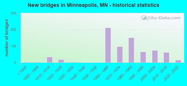
- New bridges - historical statistics
- 3Before 1900
- 41900-1909
- 351910-1919
- 201920-1929
- 41930-1939
- 11940-1949
- 2121960-1969
- 981970-1979
- 1521980-1989
- 671990-1999
- 752000-2009
- 622010-2019
- 152020-2022
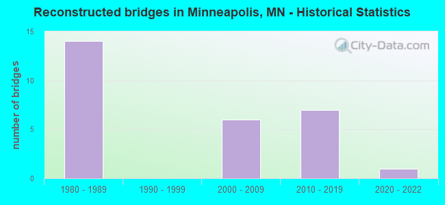
- Reconstructed bridges - Historical Statistics
- 141980-1989
- 01990-1999
- 62000-2009
- 72010-2019
- 12020-2022
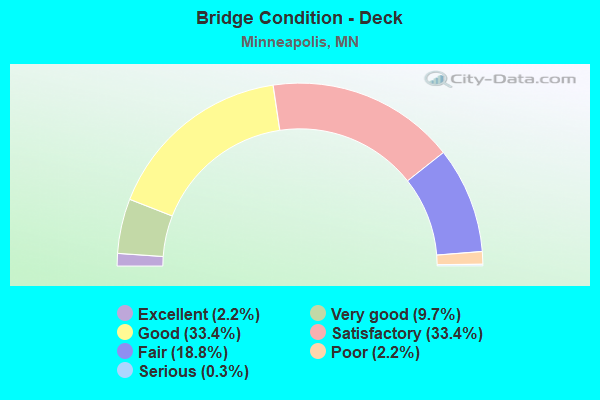
- Bridge Condition - Deck
- 2.2%Excellent
- 9.7%Very good
- 33.4%Good
- 33.4%Satisfactory
- 18.8%Fair
- 2.2%Poor
- 0.3%Serious
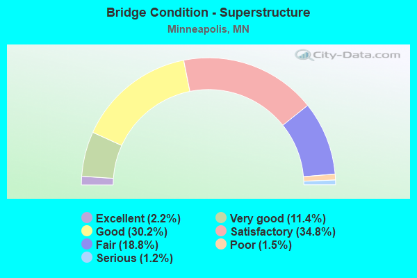
- Bridge Condition - Superstructure
- 2.2%Excellent
- 11.4%Very good
- 30.2%Good
- 34.8%Satisfactory
- 18.8%Fair
- 1.5%Poor
- 1.2%Serious
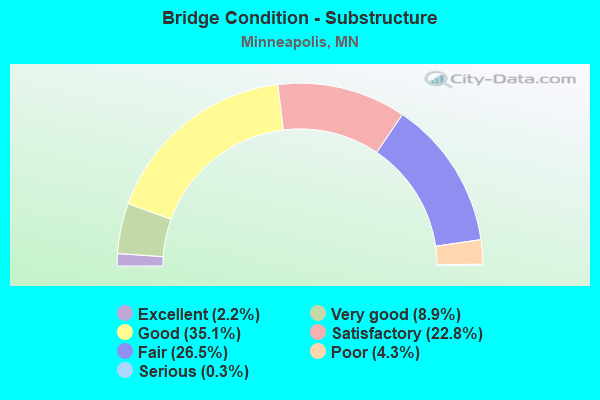
- Bridge Condition - Substructure
- 2.2%Excellent
- 8.9%Very good
- 35.1%Good
- 22.8%Satisfactory
- 26.5%Fair
- 4.3%Poor
- 0.3%Serious
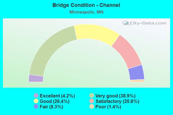
- Bridge Condition - Channel
- 4.2%Excellent
- 38.9%Very good
- 26.4%Good
- 20.8%Satisfactory
- 8.3%Fair
- 1.4%Poor
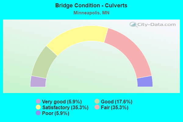
- Bridge Condition - Culverts
- 5.9%Very good
- 17.6%Good
- 35.3%Satisfactory
- 35.3%Fair
- 5.9%Poor
Find on map >> Show street view
Structure Number: L8907, Location: 0.1 MI N OF LAKE ST (Lat: 44.950286, Lng: -93.284272), Route carried "on" structure: City street 714, Year Built: 1914, Status: Posted for load, Structure Length: 3.23m (10.60ft), Average Daily Traffic: 986 (year 2018), Average Future Daily Traffic: 986 (year 2034), Features Intersected: MIDTOWN GREENWAY
Minimum Vertical Clearance: 30+ m (98+ ft), Kilometerpoint: 0.000, Lanes on structure: 1, Owner: County Highway Agency, Approaching Roadway Width: 9.8m (32.2ft), Material/Design: Concrete continuous, Design/Construction: Stringer/Multi-beam, Number Of Spans In Main Unit: 3, Length of Maximum Span: 13.7m (44.9ft), Curb or Sidewalk Widths: Left: 2.4m (7.9ft), Right: 2.4m (7.9ft), Curb-To-Curb Width: 9.1m (29.9ft), Out-to-Out Width: 14.9m (48.9ft)
Condition: Deck: Fair, Superstructure: Fair, Substructure: Fair, Operating Rating: 20.7 metric tons, Method Used To Determine Operating Rating: Load and Resistance Factor Rating (LRFR) rating reported by rating factor(RF) method using HL-93 loadings, Inventory Rating: 15.9 metric tons, Method Used To Determine Inventory Rating: Load and Resistance Factor Rating (LRFR) rating reported by rating factor(RF) method using HL-93 loadings, Structural Evaluation: Meets minimum limits, Deck Geometry: Equal to present minimum criteria, Approach Roadway Alignment: Equal to present desirable criteria, Bridge Posting: Required (Relationship of Operating Rating to Maximum Legal Load: 30.0 - 39.9% below), Length Of Structure Improvement: 1.19m (3.90ft), Designated Inspection Frequency: Every 12 months, Inspection Date: June 2021, Bridge Improvement Cost: $514,000,000, Roadway Improvement Cost: $32,000,000, Total Project Cost: $481,000,000, Deck Structure Type: Concrete Cast-file-Place, Wearing Surface/Protective System: Wearing Surface: Bituminous
Find on map >> Show street view
Structure Number: L8908, Location: 0.1 MI N OF LAKE ST (Lat: 44.950294, Lng: -93.282997), Route carried "on" structure: City street 718, Year Built: 1913, Status: Open, Structure Length: 2.87m (9.42ft), Average Daily Traffic: 3,300 (year 2013), Average Future Daily Traffic: 3,300 (year 2034), Features Intersected: MIDTOWN GREENWAY
Minimum Vertical Clearance: 30+ m (98+ ft), Kilometerpoint: 0.000, Lanes on structure: 2, Owner: County Highway Agency, Approaching Roadway Width: 11.0m (36.1ft), Material/Design: Concrete continuous, Design/Construction: Stringer/Multi-beam, Number Of Spans In Main Unit: 3, Length of Maximum Span: 9.6m (31.5ft), Curb or Sidewalk Widths: Left: 2.4m (7.9ft), Right: 2.4m (7.9ft), Curb-To-Curb Width: 9.1m (29.9ft), Out-to-Out Width: 14.9m (48.9ft)
Condition: Deck: Fair, Superstructure: Fair, Substructure: Poor, Operating Rating: 60.9 metric tons, Method Used To Determine Operating Rating: Load Factor (LF), Inventory Rating: 36.6 metric tons, Method Used To Determine Inventory Rating: Load Factor (LF), Structural Evaluation: Meets minimum limits, Deck Geometry: Meets minimum limits, Approach Roadway Alignment: Better than present minimum criteria, Length Of Structure Improvement: 1.04m (3.41ft), Designated Inspection Frequency: Every 12 months, Inspection Date: June 2021, Bridge Improvement Cost: $457,000,000, Roadway Improvement Cost: $25,000,000, Total Project Cost: $385,000,000, Deck Structure Type: Concrete Cast-file-Place, Wearing Surface/Protective System: Wearing Surface: Bituminous
Find on map >> Show street view
Structure Number: L8909, Location: 0.1 MI N OF LAKE ST (Lat: 44.950339, Lng: -93.281333), Route carried "on" structure: City street 2008, Year Built: 1914, Status: Posted for load, Structure Length: 2.88m (9.45ft), Average Daily Traffic: 5,200 (year 2013), Average Future Daily Traffic: 5,200 (year 2032), Features Intersected: MIDTOWN GREENWAY
Minimum Vertical Clearance: 30+ m (98+ ft), Kilometerpoint: 0.000, Lanes on structure: 2, Owner: County Highway Agency, Approaching Roadway Width: 11.0m (36.1ft), Material/Design: Concrete continuous, Design/Construction: Stringer/Multi-beam, Number Of Spans In Main Unit: 3, Length of Maximum Span: 9.6m (31.5ft), Curb or Sidewalk Widths: Left: 2.5m (8.2ft), Right: 2.5m (8.2ft), Curb-To-Curb Width: 9.6m (31.5ft), Out-to-Out Width: 15.5m (50.9ft)
Condition: Deck: Satisfactory, Superstructure: Fair, Substructure: Fair, Operating Rating: 40.0 metric tons, Method Used To Determine Operating Rating: Load Factor (LF), Inventory Rating: 24.0 metric tons, Method Used To Determine Inventory Rating: Load Factor (LF), Structural Evaluation: Somewhat better than minimum adequacy, Deck Geometry: High priority of corrective action, Approach Roadway Alignment: Equal to present desirable criteria, Length Of Structure Improvement: 1.07m (3.51ft), Designated Inspection Frequency: Every 12 months, Inspection Date: June 2021, Bridge Improvement Cost: $477,000,000, Roadway Improvement Cost: $25,000,000, Total Project Cost: $388,000,000, Deck Structure Type: Concrete Cast-file-Place, Wearing Surface/Protective System: Wearing Surface: Monolithic Concrete, Deck Protection: Epoxy Coated Reinforcing
Find on map >> Show street view
Structure Number: L891, Location: 0.1 MI N OF LAKE ST (Lat: 44.950339, Lng: -93.275361), Route carried "on" structure: City street 1034, Year Built: 1914, Status: Posted for load, Structure Length: 2.87m (9.42ft), Average Daily Traffic: 5,213 (year 2018), Average Future Daily Traffic: 5,213 (year 2034), Features Intersected: MIDTOWN GREENWAY
Minimum Vertical Clearance: 30+ m (98+ ft), Kilometerpoint: 0.000, Lanes on structure: 2, Owner: County Highway Agency, Approaching Roadway Width: 10.7m (35.1ft), Material/Design: Concrete continuous, Design/Construction: Stringer/Multi-beam, Number Of Spans In Main Unit: 3, Length of Maximum Span: 9.6m (31.5ft), Curb or Sidewalk Widths: Left: 2.4m (7.9ft), Right: 2.4m (7.9ft), Curb-To-Curb Width: 9.8m (32.2ft), Out-to-Out Width: 15.5m (50.9ft)
Condition: Deck: Fair, Superstructure: Fair, Substructure: Poor, Operating Rating: 41.3 metric tons, Method Used To Determine Operating Rating: Load Factor (LF), Inventory Rating: 24.9 metric tons, Method Used To Determine Inventory Rating: Load Factor (LF), Structural Evaluation: Meets minimum limits, Deck Geometry: Meets minimum limits, Approach Roadway Alignment: Better than present minimum criteria, Length Of Structure Improvement: 1.04m (3.41ft), Designated Inspection Frequency: Every 12 months, Inspection Date: June 2021, Bridge Improvement Cost: $730,000,000, Roadway Improvement Cost: $28,000,000, Total Project Cost: $427,000,000, Deck Structure Type: Concrete Cast-file-Place, Wearing Surface/Protective System: Wearing Surface: Bituminous
Find on map >> Show street view
Structure Number: L8911, Location: 0.1 MI N OF LAKE ST (Lat: 44.950356, Lng: -93.266472), Route carried "on" structure: City street 766, Year Built: 1915, Status: Posted for load, Structure Length: 2.88m (9.45ft), Average Daily Traffic: 786 (year 2018), Average Future Daily Traffic: 786 (year 2034), Features Intersected: MIDTOWN GREENWAY
Minimum Vertical Clearance: 30+ m (98+ ft), Kilometerpoint: 0.000, Lanes on structure: 2, Owner: County Highway Agency, Approaching Roadway Width: 9.8m (32.2ft), Material/Design: Concrete continuous, Design/Construction: Stringer/Multi-beam, Number Of Spans In Main Unit: 3, Length of Maximum Span: 9.6m (31.5ft), Curb or Sidewalk Widths: Left: 2.5m (8.2ft), Right: 2.5m (8.2ft), Curb-To-Curb Width: 9.6m (31.5ft), Out-to-Out Width: 15.5m (50.9ft)
Condition: Deck: Satisfactory, Superstructure: Satisfactory, Substructure: Satisfactory, Operating Rating: 41.3 metric tons, Method Used To Determine Operating Rating: Load Factor (LF), Inventory Rating: 24.9 metric tons, Method Used To Determine Inventory Rating: Load Factor (LF), Structural Evaluation: Equal to present minimum criteria, Deck Geometry: Equal to present minimum criteria, Approach Roadway Alignment: Equal to present minimum criteria, Length Of Structure Improvement: 1.07m (3.51ft), Designated Inspection Frequency: Every 24 months, Inspection Date: June 2021, Bridge Improvement Cost: $477,000,000, Roadway Improvement Cost: $20,000,000, Total Project Cost: $310,000,000, Deck Structure Type: Concrete Cast-file-Place, Wearing Surface/Protective System: Wearing Surface: Monolithic Concrete, Deck Protection: Epoxy Coated Reinforcing
Find on map >> Show street view
Structure Number: L8913, Location: 0.1 MI N OF LAKE ST (Lat: 44.950378, Lng: -93.263939), Route carried "on" structure: City street 2300, Year Built: 1915, Status: Open, Structure Length: 2.88m (9.45ft), Average Daily Traffic: 1,020 (year 2018), Average Future Daily Traffic: 1,020 (year 2034), Features Intersected: MIDTOWN GREENWAY
Minimum Vertical Clearance: 30+ m (98+ ft), Kilometerpoint: 0.000, Lanes on structure: 2, Owner: County Highway Agency, Approaching Roadway Width: 9.8m (32.2ft), Material/Design: Concrete continuous, Design/Construction: Stringer/Multi-beam, Number Of Spans In Main Unit: 3, Length of Maximum Span: 9.6m (31.5ft), Curb or Sidewalk Widths: Left: 2.4m (7.9ft), Right: 2.4m (7.9ft), Curb-To-Curb Width: 9.1m (29.9ft), Out-to-Out Width: 14.9m (48.9ft)
Condition: Deck: Satisfactory, Superstructure: Satisfactory, Substructure: Fair, Operating Rating: 66.3 metric tons, Method Used To Determine Operating Rating: Load Factor (LF), Inventory Rating: 39.6 metric tons, Method Used To Determine Inventory Rating: Load Factor (LF), Structural Evaluation: Somewhat better than minimum adequacy, Deck Geometry: Somewhat better than minimum adequacy, Approach Roadway Alignment: Better than present minimum criteria, Length Of Structure Improvement: 1.07m (3.51ft), Designated Inspection Frequency: Every 24 months, Inspection Date: June 2021, Bridge Improvement Cost: $458,000,000, Roadway Improvement Cost: $23,000,000, Total Project Cost: $349,000,000, Deck Structure Type: Concrete Cast-file-Place, Wearing Surface/Protective System: Wearing Surface: Bituminous
Find on map >> Show street view
Structure Number: L8915, Location: 0.1 MI N OF LAKE ST (Lat: 44.950364, Lng: -93.260131), Route carried "on" structure: City street 2298, Year Built: 1915, Status: Closed, Structure Length: 3.48m (11.42ft), Average Daily Traffic: 3,772 (year 2018), Average Future Daily Traffic: 3,772 (year 2034), Features Intersected: MIDTOWN GREENWAY
Minimum Vertical Clearance: 30+ m (98+ ft), Kilometerpoint: 0.000, Lanes on structure: 2, Owner: County Highway Agency, Approaching Roadway Width: 11.6m (38.1ft), Material/Design: Concrete continuous, Design/Construction: Stringer/Multi-beam, Number Of Spans In Main Unit: 4, Length of Maximum Span: 9.6m (31.5ft), Curb or Sidewalk Widths: Left: 2.4m (7.9ft), Right: 2.4m (7.9ft), Curb-To-Curb Width: 9.8m (32.2ft), Out-to-Out Width: 15.5m (50.9ft)
Condition: Deck: Serious, Superstructure: Poor, Substructure: Fair, Operating Rating: 10.4 metric tons, Method Used To Determine Operating Rating: Load and Resistance Factor Rating (LRFR) rating reported by rating factor(RF) method using HL-93 loadings, Inventory Rating: 8.1 metric tons, Method Used To Determine Inventory Rating: Load and Resistance Factor Rating (LRFR) rating reported by rating factor(RF) method using HL-93 loadings, Deck Geometry: Meets minimum limits, Approach Roadway Alignment: Somewhat better than minimum adequacy, Bridge Posting: Required (Relationship of Operating Rating to Maximum Legal Load: > 39.9% below), Length Of Structure Improvement: 1.28m (4.20ft), Designated Inspection Frequency: Every 12 months, Inspection Date: June 2021, Bridge Improvement Cost: $577,000,000, Roadway Improvement Cost: $30,000,000, Total Project Cost: $457,000,000, Deck Structure Type: Concrete Cast-file-Place, Wearing Surface/Protective System: Wearing Surface: Bituminous
Find on map >> Show street view
Structure Number: L8916, Location: 0.1 MI N OF LAKE ST (Lat: 44.950339, Lng: -93.258850), Route carried "on" structure: City street 1058, Year Built: 1915, Status: Open, Structure Length: 2.88m (9.45ft), Average Daily Traffic: 1,609 (year 2016), Average Future Daily Traffic: 1,609 (year 2034), Features Intersected: MIDTOWN GREENWAY
Minimum Vertical Clearance: 30+ m (98+ ft), Kilometerpoint: 0.000, Lanes on structure: 2, Owner: County Highway Agency, Approaching Roadway Width: 9.1m (29.9ft), Material/Design: Concrete continuous, Design/Construction: Stringer/Multi-beam, Number Of Spans In Main Unit: 3, Length of Maximum Span: 9.6m (31.5ft), Curb or Sidewalk Widths: Left: 2.4m (7.9ft), Right: 2.4m (7.9ft), Curb-To-Curb Width: 9.1m (29.9ft), Out-to-Out Width: 14.9m (48.9ft)
Condition: Deck: Fair, Superstructure: Fair, Substructure: Poor, Operating Rating: 55.3 metric tons, Method Used To Determine Operating Rating: Load Factor (LF), Inventory Rating: 33.3 metric tons, Method Used To Determine Inventory Rating: Load Factor (LF), Structural Evaluation: Meets minimum limits, Deck Geometry: Somewhat better than minimum adequacy, Approach Roadway Alignment: Equal to present minimum criteria, Length Of Structure Improvement: 1.07m (3.51ft), Designated Inspection Frequency: Every 12 months, Inspection Date: June 2021, Bridge Improvement Cost: $458,000,000, Roadway Improvement Cost: $20,000,000, Total Project Cost: $310,000,000, Deck Structure Type: Concrete Cast-file-Place, Wearing Surface/Protective System: Wearing Surface: Bituminous
Find on map >> Show street view
Structure Number: L8917, Location: 0.1 MI N OF LAKE ST (Lat: 44.950358, Lng: -93.257583), Route carried "on" structure: City street 804, Year Built: 1915, Status: Open, Structure Length: 2.88m (9.45ft), Average Daily Traffic: 1,544 (year 2018), Average Future Daily Traffic: 1,544 (year 2034), Features Intersected: MIDTOWN GREENWAY
Minimum Vertical Clearance: 30+ m (98+ ft), Kilometerpoint: 0.000, Lanes on structure: 2, Owner: County Highway Agency, Approaching Roadway Width: 9.8m (32.2ft), Material/Design: Concrete continuous, Design/Construction: Stringer/Multi-beam, Number Of Spans In Main Unit: 3, Length of Maximum Span: 9.6m (31.5ft), Curb or Sidewalk Widths: Left: 2.4m (7.9ft), Right: 2.4m (7.9ft), Curb-To-Curb Width: 9.8m (32.2ft), Out-to-Out Width: 15.5m (50.9ft)
Condition: Deck: Poor, Superstructure: Fair, Substructure: Fair, Operating Rating: 36.1 metric tons, Method Used To Determine Operating Rating: Load Factor (LF), Inventory Rating: 21.7 metric tons, Method Used To Determine Inventory Rating: Load Factor (LF), Structural Evaluation: Somewhat better than minimum adequacy, Deck Geometry: Somewhat better than minimum adequacy, Approach Roadway Alignment: Equal to present minimum criteria, Length Of Structure Improvement: 1.07m (3.51ft), Designated Inspection Frequency: Every 12 months, Inspection Date: June 2021, Bridge Improvement Cost: $478,000,000, Roadway Improvement Cost: $25,000,000, Total Project Cost: $388,000,000, Deck Structure Type: Concrete Cast-file-Place, Wearing Surface/Protective System: Wearing Surface: Bituminous
Find on map >> Show street view
Structure Number: L8918, Location: 0.1 MI N OF LAKE ST (Lat: 44.950322, Lng: -93.256308), Route carried "on" structure: City street 808, Year Built: 1915, Status: Posted for load, Structure Length: 2.88m (9.45ft), Average Daily Traffic: 1,020 (year 2014), Average Future Daily Traffic: 1,020 (year 2032), Features Intersected: MIDTOWN GREENWAY
Minimum Vertical Clearance: 30+ m (98+ ft), Kilometerpoint: 0.000, Lanes on structure: 2, Owner: County Highway Agency, Approaching Roadway Width: 9.8m (32.2ft), Material/Design: Concrete continuous, Design/Construction: Stringer/Multi-beam, Number Of Spans In Main Unit: 3, Length of Maximum Span: 9.6m (31.5ft), Curb or Sidewalk Widths: Left: 2.4m (7.9ft), Right: 2.4m (7.9ft), Curb-To-Curb Width: 9.8m (32.2ft), Out-to-Out Width: 15.5m (50.9ft)
Condition: Deck: Fair, Superstructure: Fair, Substructure: Poor, Operating Rating: 40.2 metric tons, Method Used To Determine Operating Rating: Load Factor (LF), Inventory Rating: 24.0 metric tons, Method Used To Determine Inventory Rating: Load Factor (LF), Structural Evaluation: Meets minimum limits, Deck Geometry: Somewhat better than minimum adequacy, Approach Roadway Alignment: Equal to present minimum criteria, Length Of Structure Improvement: 1.07m (3.51ft), Designated Inspection Frequency: Every 12 months, Inspection Date: June 2021, Bridge Improvement Cost: $477,000,000, Roadway Improvement Cost: $25,000,000, Total Project Cost: $388,000,000, Deck Structure Type: Concrete Cast-file-Place, Wearing Surface/Protective System: Wearing Surface: Bituminous
Find on map >> Show street view
Structure Number: L8919, Location: 0.1 MI N OF LAKE ST (Lat: 44.950311, Lng: -93.255036), Route carried "on" structure: City street 2322, Year Built: 1915, Status: Open, Structure Length: 2.88m (9.45ft), Average Daily Traffic: 1,102 (year 2018), Average Future Daily Traffic: 1,102 (year 2034), Features Intersected: MIDTOWN GREENWAY
Minimum Vertical Clearance: 30+ m (98+ ft), Kilometerpoint: 0.000, Lanes on structure: 2, Owner: County Highway Agency, Approaching Roadway Width: 9.8m (32.2ft), Material/Design: Concrete continuous, Design/Construction: Stringer/Multi-beam, Number Of Spans In Main Unit: 3, Length of Maximum Span: 9.6m (31.5ft), Curb or Sidewalk Widths: Left: 2.4m (7.9ft), Right: 2.4m (7.9ft), Curb-To-Curb Width: 9.8m (32.2ft), Out-to-Out Width: 15.5m (50.9ft)
Condition: Deck: Fair, Superstructure: Fair, Substructure: Fair, Operating Rating: 33.0 metric tons, Method Used To Determine Operating Rating: Load and Resistance Factor Rating (LRFR) rating reported by rating factor(RF) method using HL-93 loadings, Inventory Rating: 25.6 metric tons, Method Used To Determine Inventory Rating: Load and Resistance Factor Rating (LRFR) rating reported by rating factor(RF) method using HL-93 loadings, Structural Evaluation: Somewhat better than minimum adequacy, Deck Geometry: Somewhat better than minimum adequacy, Approach Roadway Alignment: Equal to present minimum criteria, Length Of Structure Improvement: 1.07m (3.51ft), Designated Inspection Frequency: Every 24 months, Inspection Date: June 2021, Bridge Improvement Cost: $477,000,000, Roadway Improvement Cost: $25,000,000, Total Project Cost: $388,000,000, Deck Structure Type: Concrete Cast-file-Place, Wearing Surface/Protective System: Wearing Surface: Bituminous
Find on map >> Show street view
Structure Number: L892, Location: 0.1 MI N OF LAKE ST (Lat: 44.950322, Lng: -93.253769), Route carried "on" structure: City street 1505, Year Built: 1916, Status: Open, Structure Length: 2.88m (9.45ft), Average Daily Traffic: 862 (year 2018), Average Future Daily Traffic: 862 (year 2034), Features Intersected: MIDTOWN GREENWAY
Minimum Vertical Clearance: 30+ m (98+ ft), Kilometerpoint: 0.000, Lanes on structure: 2, Owner: County Highway Agency, Approaching Roadway Width: 9.8m (32.2ft), Material/Design: Concrete continuous, Design/Construction: Stringer/Multi-beam, Number Of Spans In Main Unit: 3, Length of Maximum Span: 9.6m (31.5ft), Curb or Sidewalk Widths: Left: 2.4m (7.9ft), Right: 2.4m (7.9ft), Curb-To-Curb Width: 9.8m (32.2ft), Out-to-Out Width: 15.5m (50.9ft)
Condition: Deck: Good, Superstructure: Good, Substructure: Good, Operating Rating: 62.4 metric tons, Method Used To Determine Operating Rating: Allowable Stress (AS), Inventory Rating: 24.7 metric tons, Method Used To Determine Inventory Rating: Allowable Stress (AS), Structural Evaluation: Equal to present minimum criteria, Deck Geometry: Equal to present minimum criteria, Approach Roadway Alignment: Equal to present minimum criteria, Length Of Structure Improvement: 1.07m (3.51ft), Designated Inspection Frequency: Every 24 months, Inspection Date: June 2021, Bridge Improvement Cost: $477,000,000, Roadway Improvement Cost: $28,000,000, Total Project Cost: $427,000,000, Deck Structure Type: Concrete Cast-file-Place, Wearing Surface/Protective System: Wearing Surface: Low Slump Concrete
Find on map >> Show street view
Structure Number: L8921, Location: 0.1 MI N OF LAKE ST (Lat: 44.950356, Lng: -93.251206), Route carried "on" structure: City street 1893, Year Built: 1916, Status: Open, Structure Length: 2.88m (9.45ft), Average Daily Traffic: 970 (year 2018), Average Future Daily Traffic: 970 (year 2034), Features Intersected: MIDTOWN GREENWAY
Minimum Vertical Clearance: 30+ m (98+ ft), Kilometerpoint: 0.000, Lanes on structure: 1, Owner: County Highway Agency, Approaching Roadway Width: 9.8m (32.2ft), Material/Design: Concrete continuous, Design/Construction: Stringer/Multi-beam, Number Of Spans In Main Unit: 3, Length of Maximum Span: 9.6m (31.5ft), Curb or Sidewalk Widths: Left: 2.4m (7.9ft), Right: 2.4m (7.9ft), Curb-To-Curb Width: 9.8m (32.2ft), Out-to-Out Width: 15.5m (50.9ft)
Condition: Deck: Good, Superstructure: Good, Substructure: Good, Operating Rating: 62.2 metric tons, Method Used To Determine Operating Rating: Allowable Stress (AS), Inventory Rating: 37.2 metric tons, Method Used To Determine Inventory Rating: Allowable Stress (AS), Structural Evaluation: Better than present minimum criteria, Deck Geometry: Equal to present minimum criteria, Approach Roadway Alignment: Equal to present minimum criteria, Length Of Structure Improvement: 1.07m (3.51ft), Designated Inspection Frequency: Every 24 months, Inspection Date: June 2021, Bridge Improvement Cost: $477,000,000, Roadway Improvement Cost: $22,000,000, Total Project Cost: $343,000,000, Deck Structure Type: Concrete Cast-file-Place, Wearing Surface/Protective System: Wearing Surface: Low Slump Concrete
Find on map >> Show street view
Structure Number: L8922, Location: 0.1 MI N OF LAKE ST (Lat: 44.950333, Lng: -93.249947), Route carried "on" structure: City street 1062, Year Built: 1916, Status: Posted for load, Structure Length: 2.88m (9.45ft), Average Daily Traffic: 1,822 (year 2018), Average Future Daily Traffic: 1,822 (year 2034), Features Intersected: MIDTOWN GREENWAY
Minimum Vertical Clearance: 30+ m (98+ ft), Kilometerpoint: 0.000, Lanes on structure: 1, Owner: County Highway Agency, Approaching Roadway Width: 9.8m (32.2ft), Material/Design: Concrete continuous, Design/Construction: Stringer/Multi-beam, Number Of Spans In Main Unit: 3, Length of Maximum Span: 9.6m (31.5ft), Curb or Sidewalk Widths: Left: 2.4m (7.9ft), Right: 2.4m (7.9ft), Curb-To-Curb Width: 9.8m (32.2ft), Out-to-Out Width: 15.5m (50.9ft)
Condition: Deck: Good, Superstructure: Fair, Substructure: Fair, Operating Rating: 40.2 metric tons, Method Used To Determine Operating Rating: Load Factor (LF), Inventory Rating: 24.0 metric tons, Method Used To Determine Inventory Rating: Load Factor (LF), Structural Evaluation: Somewhat better than minimum adequacy, Deck Geometry: Somewhat better than minimum adequacy, Approach Roadway Alignment: Equal to present minimum criteria, Length Of Structure Improvement: 1.07m (3.51ft), Designated Inspection Frequency: Every 24 months, Inspection Date: June 2021, Bridge Improvement Cost: $477,000,000, Roadway Improvement Cost: $23,000,000, Total Project Cost: $349,000,000, Deck Structure Type: Concrete Cast-file-Place, Wearing Surface/Protective System: Wearing Surface: Monolithic Concrete, Deck Protection: Epoxy Coated Reinforcing
Find on map >> Show street view
Structure Number: L8923, Location: 0.1 MI N OF LAKE ST (Lat: 44.950375, Lng: -93.248664), Route carried "on" structure: City street 1064, Year Built: 1916, Status: Open, Structure Length: 2.90m (9.51ft), Average Daily Traffic: 1,670 (year 2018), Average Future Daily Traffic: 1,670 (year 2034), Features Intersected: MIDTOWN GREENWAY
Minimum Vertical Clearance: 30+ m (98+ ft), Kilometerpoint: 0.000, Lanes on structure: 1, Owner: County Highway Agency, Approaching Roadway Width: 9.8m (32.2ft), Material/Design: Concrete continuous, Design/Construction: Stringer/Multi-beam, Number Of Spans In Main Unit: 3, Length of Maximum Span: 9.9m (32.5ft), Curb or Sidewalk Widths: Left: 2.4m (7.9ft), Right: 2.4m (7.9ft), Curb-To-Curb Width: 9.8m (32.2ft), Out-to-Out Width: 15.5m (50.9ft)
Condition: Deck: Poor, Superstructure: Poor, Substructure: Poor, Operating Rating: 56.5 metric tons, Method Used To Determine Operating Rating: Load Factor (LF), Inventory Rating: 33.8 metric tons, Method Used To Determine Inventory Rating: Load Factor (LF), Structural Evaluation: Meets minimum limits, Deck Geometry: Somewhat better than minimum adequacy, Approach Roadway Alignment: Equal to present minimum criteria, Length Of Structure Improvement: 1.07m (3.51ft), Designated Inspection Frequency: Every 12 months, Inspection Date: May 2021, Bridge Improvement Cost: $735,000,000, Roadway Improvement Cost: $23,000,000, Total Project Cost: $355,000,000, Deck Structure Type: Concrete Cast-file-Place, Wearing Surface/Protective System: Wearing Surface: Bituminous
Find on map >> Show street view
Structure Number: L9328, Location: 0.2 MI N OF LK HARRIET P (Lat: 44.931197, Lng: -93.308328), Route carried "on" structure: City street 1206, Year Built: 1900, Status: Open, Structure Length: 1.22m (4.00ft), Average Daily Traffic: 2,966 (year 2015), Average Future Daily Traffic: 2,966 (year 2034), Features Intersected: Como-Harriet Streetcar
Minimum Vertical Clearance: 30+ m (98+ ft), Kilometerpoint: 0.000, Lanes on structure: 2, Owner: Local Park, Forest, or Reservation Agency, Approaching Roadway Width: 9.1m (29.9ft), Material/Design: Concrete, Design/Construction: Arch - Deck, Number Of Spans In Main Unit: 1, Length of Maximum Span: 11.6m (38.1ft), Curb or Sidewalk Widths: Left: 4.6m (15.1ft), Right: 4.6m (15.1ft), Curb-To-Curb Width: 9.1m (29.9ft), Out-to-Out Width: 19.2m (63.0ft)
Condition: Superstructure: Satisfactory, Substructure: Satisfactory, Operating Rating: 29.4 metric tons, Method Used To Determine Operating Rating: Field evaluation and documented engineering judgment, Inventory Rating: 19.6 metric tons, Method Used To Determine Inventory Rating: Field evaluation and documented engineering judgment, Structural Evaluation: Somewhat better than minimum adequacy, Deck Geometry: Meets minimum limits, Underclear: High priority of corrective action, Approach Roadway Alignment: Equal to present minimum criteria, Designated Inspection Frequency: Every 24 months, Inspection Date: June 2021, Wearing Surface/Protective System: Wearing Surface: Bituminous
Find on map >> Show street view
Structure Number: L9329, Location: At W 43RD St; QUEEN AVE (Lat: 44.924533, Lng: -93.311286), Route carried "on" structure: City street 1719, Year Built: 1905, Status: Open, Structure Length: 1.28m (4.20ft), Average Daily Traffic: 774 (year 2015), Truck Traffic: 90%, Average Future Daily Traffic: 774 (year 2029), Features Intersected: COMO-HARRIET STREETCAR
Minimum Vertical Clearance: 30+ m (98+ ft), Kilometerpoint: 0.000, Lanes on structure: 2, Owner: City or Municipal Highway Agency, Approaching Roadway Width: 10.1m (33.1ft), Skew: 3 degrees, Material/Design: Concrete, Design/Construction: Culvert, Number Of Spans In Main Unit: 1, Length of Maximum Span: 11.0m (36.1ft), Curb or Sidewalk Widths: Left: 2.1m (6.9ft), Right: 2.1m (6.9ft)
Condition: Culverts: Satisfactory, Operating Rating: 29.4 metric tons, Method Used To Determine Operating Rating: Field evaluation and documented engineering judgment, Inventory Rating: 19.6 metric tons, Method Used To Determine Inventory Rating: Field evaluation and documented engineering judgment, Structural Evaluation: Somewhat better than minimum adequacy, Approach Roadway Alignment: Meets minimum limits, Length Of Structure Improvement: 0.55m (1.80ft), Designated Inspection Frequency: Every 24 months, Inspection Date: June 2021, Bridge Improvement Cost: $394,000,000, Roadway Improvement Cost: $14,000,000, Total Project Cost: $210,000,000
Find on map >> Show street view
Structure Number: R0834, Location: MSP INTL AIRPORT (Lat: 44.883169, Lng: -93.210750), Route carried "on" structure: ServiceOther road 8, Year Built: 1993, Status: Open, Structure Length: 47.79m (156.79ft), Average Daily Traffic: 11,000 (year 2019), Average Future Daily Traffic: 1 (year 2039), Design Load: HS 20, Features Intersected: TERMINAL ROAD 1
Minimum Vertical Clearance: 30+ m (98+ ft), Kilometerpoint: 0.000, Lanes on structure: 4, Lanes under structure: 9, Owner: Private, Approaching Roadway Width: 7.9m (25.9ft), Skew: 30 degrees, Material/Design: Steel, Design/Construction: Girder and Floorbeam System, Number Of Spans In Main Unit: 42, Number Of Approach Spans: 2, Length of Maximum Span: 15.2m (49.9ft), Curb or Sidewalk Widths: Left: 6.1m (20.0ft), Right: 0.0m, Curb-To-Curb Width: 8.5m (27.9ft), Out-to-Out Width: 11.0m (36.1ft)
Condition: Deck: Fair, Superstructure: Fair, Substructure: Satisfactory, Operating Rating: 59.2 metric tons, Method Used To Determine Operating Rating: Load Factor (LF), Inventory Rating: 35.5 metric tons, Method Used To Determine Inventory Rating: Load Factor (LF), Structural Evaluation: Somewhat better than minimum adequacy, Deck Geometry: High priority of replacement, Underclear: High priority of corrective action, Approach Roadway Alignment: Equal to present minimum criteria, Designated Inspection Frequency: Every 24 months, Inspection Date: July 2021, Deck Structure Type: Concrete Cast-file-Place, Wearing Surface/Protective System: Wearing Surface: Low Slump Concrete
Find on map >> Show street view
Structure Number: 244, Location: 0.3 MI NE OF JCT TH 952A (Lat: 44.983417, Lng: -93.258858), Route carried "under" structure: City street 1863, Year Built: 1917, Structure Length: 0. m, Average Daily Traffic: 500 (year 1993), Features Intersected: MISS RVR; MAIN; W RVR PK, Facility Carried by Structure: MN 65
Minimum Vertical Clearance: 9.11m (29.89ft), Kilometerpoint: 0.000, Lanes on structure: 4, Lanes under structure: 2, Material/Design: Concrete, Design/Construction: Arch - Deck, Length of Maximum Span: 72.1m (236.5ft)
Find on map >> Show street view
Structure Number: 244, Location: 0.3 MI NE OF JCT TH 952A (Lat: 44.983417, Lng: -93.258858), Route carried "under" structure: City street 699, Year Built: 1917, Structure Length: 0. m, Average Daily Traffic: 2,100 (year 1995), Features Intersected: MISS RVR; MAIN; W RVR PK, Facility Carried by Structure: MN 65
Minimum Vertical Clearance: 7.29m (23.92ft), Kilometerpoint: 0.000, Lanes on structure: 4, Lanes under structure: 4, Material/Design: Concrete, Design/Construction: Arch - Deck, Length of Maximum Span: 72.1m (236.5ft)
Find on map >> Show street view
Structure Number: 2441, Location: 0.5 MI E OF JCT CSAH 48 (Lat: 44.963919, Lng: -93.222656), Route carried "under" structure: City street 701, Year Built: 1923, Structure Length: 0. m, Average Daily Traffic: 5,800 (year 1997), Features Intersected: W RIVER RD; MISS RIV, Facility Carried by Structure: CSAH 5
Minimum Vertical Clearance: 3.81m (12.50ft), Kilometerpoint: 0.000, Lanes on structure: 4, Lanes under structure: 2, Material/Design: Concrete, Design/Construction: Arch - Deck, Length of Maximum Span: 132.6m (435.0ft)
Find on map >> Show street view
Structure Number: 27, Location: AT JCT TH 65; 94 (Lat: 44.965942, Lng: -93.269922), Route carried "under" structure: Interstate 94, Year Built: 2018, Structure Length: 0. m, Average Daily Traffic: 145,290 (year 2019), Truck Traffic: 4%, Features Intersected: I 94, Facility Carried by Structure: MN 65
Minimum Vertical Clearance: 5.12m (16.80ft), Kilometerpoint: 0.000, Lanes under structure: 6, Material/Design: Prestressed concrete, Design/Construction: Stringer/Multi-beam, Length of Maximum Span: 37.4m (122.7ft)
Find on map >> Show street view
Structure Number: 27003, Location: 0.3 MI S OF JCT TH 394 (Lat: 44.969953, Lng: -93.287636), Route carried "under" structure: Interstate 94, Year Built: 1988, Structure Length: 0. m, Average Daily Traffic: 122,000 (year 2019), Truck Traffic: 4%, Features Intersected: I 94, LYNDALE; HENN AVE, Facility Carried by Structure: PEDESTRIAN
Minimum Vertical Clearance: 5.24m (17.19ft), Kilometerpoint: 0.000, Lanes on structure: 6, Lanes under structure: 6, Material/Design: Steel, Design/Construction: Truss - Thru, Length of Maximum Span: 48.5m (159.1ft)
Find on map >> Show street view
Structure Number: 27003, Location: 0.3 MI S OF JCT TH 394 (Lat: 44.969953, Lng: -93.287636), Route carried "under" structure: City street 435, Year Built: 1988, Structure Length: 0. m, Average Daily Traffic: 25,700 (year 2005), Features Intersected: I 94, LYNDALE; HENN AVE, Facility Carried by Structure: PEDESTRIAN
Minimum Vertical Clearance: 5.24m (17.19ft), Kilometerpoint: 0.000, Lanes on structure: 6, Lanes under structure: 6, Material/Design: Steel, Design/Construction: Truss - Thru, Length of Maximum Span: 48.5m (159.1ft)
Find on map >> Show street view
Structure Number: 27003, Location: 0.3 MI S OF JCT TH 394 (Lat: 44.969953, Lng: -93.287636), Route carried "under" structure: City street 313, Year Built: 1988, Structure Length: 0. m, Average Daily Traffic: 29,600 (year 2005), Features Intersected: I 94, LYNDALE; HENN AVE, Facility Carried by Structure: PEDESTRIAN
Minimum Vertical Clearance: 5.24m (17.19ft), Kilometerpoint: 0.000, Lanes on structure: 6, Lanes under structure: 6, Material/Design: Steel, Design/Construction: Truss - Thru, Length of Maximum Span: 48.5m (159.1ft)
Find on map >> Show street view
Structure Number: 27003, Location: 0.3 MI S OF JCT TH 394 (Lat: 44.969953, Lng: -93.287636), Route carried "under" structure: Ramp City street 6593, Year Built: 1988, Structure Length: 0. m, Average Daily Traffic: 1 (year 2019), Features Intersected: I 94, LYNDALE; HENN AVE, Facility Carried by Structure: PEDESTRIAN
Minimum Vertical Clearance: 5.24m (17.19ft), Kilometerpoint: 0.000, Lanes under structure: 2, Material/Design: Steel, Design/Construction: Truss - Thru, Length of Maximum Span: 48.5m (159.1ft)
Find on map >> Show street view
Structure Number: 27021, Location: AT THE JCT TH 77; 62 (Lat: 44.895794, Lng: -93.247214), Route carried "under" structure: County highway 152, Year Built: 1962, Structure Length: 0. m, Average Daily Traffic: 17,941 (year 2019), Truck Traffic: 1%, Features Intersected: TH 77, Facility Carried by Structure: MN 62
Minimum Vertical Clearance: 4.76m (15.62ft), Kilometerpoint: 0.000, Lanes on structure: 3, Lanes under structure: 5, Material/Design: Steel continuous, Design/Construction: Stringer/Multi-beam, Length of Maximum Span: 29.6m (97.1ft)
Find on map >> Show street view
Structure Number: 27022, Location: AT THE JCT TH 77; 62 (Lat: 44.895539, Lng: -93.247200), Route carried "under" structure: State highway 77, Year Built: 1962, Structure Length: 0. m, Average Daily Traffic: 66,000 (year 2019), Truck Traffic: 3%, Features Intersected: TH 77, Facility Carried by Structure: MN 62
Minimum Vertical Clearance: 4.79m (15.72ft), Kilometerpoint: 0.000, Lanes on structure: 3, Lanes under structure: 6, Material/Design: Steel continuous, Design/Construction: Stringer/Multi-beam, Length of Maximum Span: 28.6m (93.8ft)
Find on map >> Show street view
Structure Number: 2703, Location: 0.2 MI E OF JCT TH 35W (Lat: 44.971761, Lng: -93.247231), Route carried "under" structure: County highway 122, Year Built: 1968, Structure Length: 0. m, Average Daily Traffic: 16,000 (year 2005), Features Intersected: CSAH 122 (WASHINGTON), Facility Carried by Structure: CSAH 152
Minimum Vertical Clearance: 5.91m (19.39ft), Kilometerpoint: 0.000, Lanes on structure: 4, Lanes under structure: 5, Material/Design: Concrete continuous, Design/Construction: Slab, Length of Maximum Span: 20.7m (67.9ft)
Find on map >> Show street view
Structure Number: 27055, Location: 2.8 MI S OF JCT TH 694 (Lat: 45.027642, Lng: -93.263992), Route carried "under" structure: State highway 47, Year Built: 1998, Structure Length: 0. m, Average Daily Traffic: 13,781 (year 2019), Truck Traffic: 7%, Features Intersected: TH 47 (University Ave), Facility Carried by Structure: MSAS 454
Minimum Vertical Clearance: 5.24m (17.19ft), Kilometerpoint: 0.000, Lanes on structure: 2, Lanes under structure: 4, Material/Design: Steel continuous, Design/Construction: Stringer/Multi-beam, Length of Maximum Span: 37.7m (123.7ft)
Find on map >> Show street view
Structure Number: 27063, Location: 0.6 MI SE OF JCT TH 94 (Lat: 44.960133, Lng: -93.246689), Route carried "under" structure: County highway 152, Year Built: 1995, Structure Length: 0. m, Average Daily Traffic: 17,500 (year 2005), Features Intersected: CEDAR AVE, Facility Carried by Structure: MN 55
Minimum Vertical Clearance: 4.82m (15.81ft), Kilometerpoint: 0.000, Lanes on structure: 4, Lanes under structure: 4, Material/Design: Steel continuous, Design/Construction: Stringer/Multi-beam, Length of Maximum Span: 13.4m (44.0ft)
Find on map >> Show street view
Structure Number: 27071, Location: 0.3 MI SE OF JCT TH 94 (Lat: 44.962600, Lng: -93.249228), Route carried "under" structure: County highway 5, Year Built: 1995, Structure Length: 0. m, Average Daily Traffic: 14,200 (year 2005), Features Intersected: FRANKLIN AVE
Minimum Vertical Clearance: 5.46m (17.91ft), Kilometerpoint: 0.000, Lanes on structure: 5, Lanes under structure: 4, Material/Design: Steel continuous, Design/Construction: Stringer/Multi-beam, Length of Maximum Span: 22.4m (73.5ft)
Find on map >> Show street view
Structure Number: 27099, Location: AT THE JCT HENN AVE (Lat: 44.964778, Lng: -93.288972), Route carried "under" structure: City street 425, Year Built: 1965, Structure Length: 0. m, Average Daily Traffic: 8,800 (year 2006), Features Intersected: HENNEPIN NB, Facility Carried by Structure: MSAS 435
Minimum Vertical Clearance: 4.79m (15.72ft), Kilometerpoint: 0.000, Lanes on structure: 2, Lanes under structure: 2, Material/Design: Prestressed concrete, Design/Construction: Stringer/Multi-beam, Length of Maximum Span: 16.0m (52.5ft)
Find on map >> Show street view
Structure Number: 271, Location: 0.2 Mi North of Jct TH 94 (Lat: 44.970108, Lng: -93.269347), Route carried "under" structure: State highway 65, Year Built: 1966, Structure Length: 0. m, Average Daily Traffic: 25,551 (year 2019), Truck Traffic: 3%, Features Intersected: TH 65, Facility Carried by Structure: MSAS 224
Minimum Vertical Clearance: 4.82m (15.81ft), Kilometerpoint: 0.000, Lanes on structure: 3, Lanes under structure: 5, Material/Design: Steel continuous, Design/Construction: Stringer/Multi-beam, Length of Maximum Span: 30.4m (99.7ft)
Find on map >> Show street view
Structure Number: 27111, Location: 0.1 MI S OF WASHINGTON A (Lat: 44.973428, Lng: -93.254836), Route carried "under" structure: City street 340, Year Built: 1969, Structure Length: 0. m, Average Daily Traffic: 9,100 (year 2007), Features Intersected: 3RD; 4TH ST, Facility Carried by Structure: MSAS 213
Minimum Vertical Clearance: 6.22m (20.41ft), Kilometerpoint: 0.000, Lanes on structure: 2, Lanes under structure: 3, Material/Design: Steel continuous, Design/Construction: Stringer/Multi-beam, Length of Maximum Span: 24.5m (80.4ft)
Find on map >> Show street view
Structure Number: 27111, Location: 0.1 MI S OF WASHINGTON A (Lat: 44.973428, Lng: -93.254836), Route carried "under" structure: City street 341, Year Built: 1969, Structure Length: 0. m, Average Daily Traffic: 6,500 (year 2007), Features Intersected: 3RD; 4TH ST, Facility Carried by Structure: MSAS 213
Minimum Vertical Clearance: 4.57m (14.99ft), Kilometerpoint: 0.000, Lanes on structure: 2, Lanes under structure: 2, Material/Design: Steel continuous, Design/Construction: Stringer/Multi-beam, Length of Maximum Span: 24.5m (80.4ft)
Find on map >> Show street view
Structure Number: 27177, Location: 0.3 MI SE OF JCT TH 94 (Lat: 44.962361, Lng: -93.249394), Route carried "under" structure: County highway 5, Year Built: 1967, Structure Length: 0. m, Average Daily Traffic: 14,200 (year 2005), Features Intersected: FRANKLIN AVE
Minimum Vertical Clearance: 4.72m (15.49ft), Kilometerpoint: 0.000, Lanes on structure: 5, Lanes under structure: 4, Material/Design: Steel continuous, Design/Construction: Stringer/Multi-beam, Length of Maximum Span: 22.5m (73.8ft)
Find on map >> Show street view
Structure Number: 27178, Location: 0.6 MI SE OF JCT TH 94 (Lat: 44.959983, Lng: -93.246719), Route carried "under" structure: County highway 152, Year Built: 1967, Structure Length: 0. m, Average Daily Traffic: 17,500 (year 2005), Features Intersected: CEDAR AVE, Facility Carried by Structure: MN 55
Minimum Vertical Clearance: 5.03m (16.50ft), Kilometerpoint: 0.000, Lanes on structure: 4, Lanes under structure: 4, Material/Design: Steel continuous, Design/Construction: Stringer/Multi-beam, Length of Maximum Span: 13.4m (44.0ft)
Find on map >> Show street view
Structure Number: 27201, Location: 1.2 MI S OF JCT TH 94 (Lat: 44.948422, Lng: -93.238189), Route carried "under" structure: County highway 3, Year Built: 1996, Structure Length: 0. m, Average Daily Traffic: 20,000 (year 2005), Features Intersected: LAKE ST, Facility Carried by Structure: MN 55
Minimum Vertical Clearance: 5.27m (17.29ft), Kilometerpoint: 0.000, Lanes on structure: 4, Lanes under structure: 6, Material/Design: Steel continuous, Design/Construction: Box Beam or Girders - Multiple, Length of Maximum Span: 71.6m (234.9ft)
Find on map >> Show street view
Structure Number: 27202, Location: 0.5 MI S OF JCT TH 94 (Lat: 44.958703, Lng: -93.245339), Route carried "under" structure: State highway 55, Year Built: 1998, Structure Length: 0. m, Average Daily Traffic: 78,000 (year 2019), Truck Traffic: 4%, Features Intersected: TH 55; NB OFF RAMP, Facility Carried by Structure: PEDESTRIAN
Minimum Vertical Clearance: 5.52m (18.11ft), Kilometerpoint: 0.000, Lanes on structure: 6, Lanes under structure: 7, Material/Design: Steel continuous, Design/Construction: Stringer/Multi-beam, Length of Maximum Span: 30.5m (100.1ft)
Find on map >> Show street view
Structure Number: 27202, Location: 0.5 MI S OF JCT TH 94 (Lat: 44.958703, Lng: -93.245339), Route carried "under" structure: Ramp State highway 3950, Year Built: 1998, Structure Length: 0. m, Average Daily Traffic: 1 (year 2009), Features Intersected: TH 55; NB OFF RAMP, Facility Carried by Structure: PEDESTRIAN
Minimum Vertical Clearance: 5.55m (18.21ft), Kilometerpoint: 0.000, Lanes on structure: 1, Lanes under structure: 7, Material/Design: Steel continuous, Design/Construction: Stringer/Multi-beam, Length of Maximum Span: 30.5m (100.1ft)
Find on map >> Show street view
Structure Number: 27202, Location: 0.5 MI S OF JCT TH 94 (Lat: 44.958703, Lng: -93.245339), Route carried "under" structure: Ramp State highway 5471, Year Built: 1998, Structure Length: 0. m, Average Daily Traffic: 1 (year 2019), Features Intersected: TH 55; NB OFF RAMP, Facility Carried by Structure: PEDESTRIAN
Minimum Vertical Clearance: 5.24m (17.19ft), Kilometerpoint: 0.000, Lanes under structure: 1, Material/Design: Steel continuous, Design/Construction: Stringer/Multi-beam, Length of Maximum Span: 30.5m (100.1ft)
Find on map >> Show street view
Structure Number: 27262, Location: 1.2 MI S OF JCT TH 94 (Lat: 44.952381, Lng: -93.241219), Route carried "under" structure: Ramp State highway 5641, Year Built: 2002, Structure Length: 0. m, Average Daily Traffic: 1 (year 2009), Features Intersected: TH 55, RAMP; LAKE ST, Facility Carried by Structure: RAILROAD
Minimum Vertical Clearance: 5.76m (18.90ft), Kilometerpoint: 0.000, Lanes on structure: 1, Lanes under structure: 12, Material/Design: Prestressed concrete, Design/Construction: Box Beam or Girders - Multiple, Length of Maximum Span: 56.3m (184.7ft)
Find on map >> Show street view
Structure Number: 27262, Location: 1.2 MI S OF JCT TH 94 (Lat: 44.952381, Lng: -93.241219), Route carried "under" structure: State highway 55, Year Built: 2002, Structure Length: 0. m, Average Daily Traffic: 33,078 (year 2019), Truck Traffic: 4%, Features Intersected: TH 55, RAMP; LAKE ST, Facility Carried by Structure: RAILROAD
Minimum Vertical Clearance: 5.88m (19.29ft), Kilometerpoint: 0.000, Lanes on structure: 5, Lanes under structure: 12, Material/Design: Prestressed concrete, Design/Construction: Box Beam or Girders - Multiple, Length of Maximum Span: 56.3m (184.7ft)
Find on map >> Show street view
Structure Number: 27262, Location: 1.2 MI S OF JCT TH 94 (Lat: 44.952381, Lng: -93.241219), Route carried "under" structure: County highway 3, Year Built: 2002, Structure Length: 0. m, Average Daily Traffic: 20,000 (year 2005), Features Intersected: TH 55, RAMP; LAKE ST, Facility Carried by Structure: RAILROAD
Minimum Vertical Clearance: 4.97m (16.31ft), Kilometerpoint: 0.000, Lanes on structure: 6, Lanes under structure: 12, Material/Design: Prestressed concrete, Design/Construction: Box Beam or Girders - Multiple, Length of Maximum Span: 56.3m (184.7ft)
Find on map >> Show street view
Structure Number: 27264, Location: NEAR THE JCT TH62; 55 (Lat: 44.899231, Lng: -93.199753), Route carried "under" structure: Ramp State highway 5867, Year Built: 2003, Structure Length: 0. m, Average Daily Traffic: 46,500 (year 2004), Truck Traffic: 3%, Features Intersected: TH 55, 62; RAMP, Facility Carried by Structure: RAILROAD
Minimum Vertical Clearance: 7.29m (23.92ft), Kilometerpoint: 0.000, Lanes on structure: 6, Lanes under structure: 14, Material/Design: Prestressed concrete, Design/Construction: Box Beam or Girders - Multiple, Length of Maximum Span: 57.2m (187.7ft)
Find on map >> Show street view
Structure Number: 27264, Location: NEAR THE JCT TH62; 55 (Lat: 44.899231, Lng: -93.199753), Route carried "under" structure: State highway 55, Year Built: 2003, Structure Length: 0. m, Average Daily Traffic: 26,611 (year 2019), Truck Traffic: 4%, Features Intersected: TH 55, 62; RAMP, Facility Carried by Structure: RAILROAD
Minimum Vertical Clearance: 4.97m (16.31ft), Kilometerpoint: 0.000, Lanes on structure: 6, Lanes under structure: 14, Material/Design: Prestressed concrete, Design/Construction: Box Beam or Girders - Multiple, Length of Maximum Span: 57.2m (187.7ft)
Find on map >> Show street view
Structure Number: 27264, Location: NEAR THE JCT TH62; 55 (Lat: 44.899231, Lng: -93.199753), Route carried "under" structure: Ramp State highway 5867, Year Built: 2003, Structure Length: 0. m, Average Daily Traffic: 5,000 (year 2000), Features Intersected: TH 55, 62; RAMP, Facility Carried by Structure: RAILROAD
Minimum Vertical Clearance: 7.59m (24.90ft), Kilometerpoint: 0.000, Lanes on structure: 2, Lanes under structure: 14, Material/Design: Prestressed concrete, Design/Construction: Box Beam or Girders - Multiple, Length of Maximum Span: 57.2m (187.7ft)
Find on map >> Show street view
Structure Number: 27405, Location: 1.2 MI N OF JCT MN 62 (Lat: 44.908967, Lng: -93.275017), Route carried "under" structure: City street 1025, Year Built: 2008, Structure Length: 0. m, Average Daily Traffic: 500 (year 1974), Features Intersected: MINNEHAHA PKWY AND CREEK, Facility Carried by Structure: I 35W
Minimum Vertical Clearance: 4.39m (14.40ft), Kilometerpoint: 0.000, Lanes on structure: 5, Lanes under structure: 2, Material/Design: Steel continuous, Design/Construction: Stringer/Multi-beam, Length of Maximum Span: 39.8m (130.6ft)
Find on map >> Show street view
Structure Number: 27406, Location: 1.2 MI N OF JCT MN 62 (Lat: 44.909175, Lng: -93.274597), Route carried "under" structure: City street 1025, Year Built: 2008, Structure Length: 0. m, Average Daily Traffic: 500 (year 1974), Features Intersected: MINNEHAHA PKWY; CREEK, Facility Carried by Structure: I 35W
Minimum Vertical Clearance: 4.54m (14.90ft), Kilometerpoint: 0.000, Lanes on structure: 5, Lanes under structure: 2, Material/Design: Steel continuous, Design/Construction: Stringer/Multi-beam, Length of Maximum Span: 39.8m (130.6ft)
Find on map >> Show street view
Structure Number: 27409, Location: 1.0 MI NE OF JCT TH94 (Lat: 44.979031, Lng: -93.245156), Route carried "under" structure: City street 1863, Year Built: 2008, Structure Length: 0. m, Average Daily Traffic: 30 (year 2010), Features Intersected: MISS R, W R PKWY, RD; RR, Facility Carried by Structure: I 35W
Minimum Vertical Clearance: 3.99m (13.09ft), Kilometerpoint: 0.000, Lanes on structure: 5, Lanes under structure: 2, Material/Design: Prestressed concrete, Design/Construction: Segmental Box Girder, Length of Maximum Span: 154.0m (505.2ft)
Find on map >> Show street view
Structure Number: 27409, Location: 1.0 MI NE OF JCT TH94 (Lat: 44.979031, Lng: -93.245156), Route carried "under" structure: City street 1863, Year Built: 2008, Structure Length: 0. m, Average Daily Traffic: 2,300 (year 2007), Features Intersected: MISS R, W R PKWY, RD; RR, Facility Carried by Structure: I 35W
Minimum Vertical Clearance: 3.99m (13.09ft), Kilometerpoint: 0.000, Lanes on structure: 5, Lanes under structure: 2, Material/Design: Prestressed concrete, Design/Construction: Segmental Box Girder, Length of Maximum Span: 154.0m (505.2ft)
Find on map >> Show street view
Structure Number: 2741, Location: 1.0 MI NE OF JCT TH 94 (Lat: 44.978981, Lng: -93.244597), Route carried "under" structure: City street 1863, Year Built: 2008, Structure Length: 0. m, Average Daily Traffic: 30 (year 2010), Features Intersected: MISS R, W R PKWY, RD; RR, Facility Carried by Structure: I 35W
Minimum Vertical Clearance: 4.39m (14.40ft), Kilometerpoint: 0.000, Lanes on structure: 5, Lanes under structure: 2, Material/Design: Prestressed concrete, Design/Construction: Segmental Box Girder, Length of Maximum Span: 151.9m (498.4ft)
Find on map >> Show street view
Structure Number: 2741, Location: 1.0 MI NE OF JCT TH 94 (Lat: 44.978981, Lng: -93.244597), Route carried "under" structure: City street 1863, Year Built: 2008, Structure Length: 0. m, Average Daily Traffic: 2,300 (year 2007), Features Intersected: MISS R, W R PKWY, RD; RR, Facility Carried by Structure: I 35W
Minimum Vertical Clearance: 4.39m (14.40ft), Kilometerpoint: 0.000, Lanes on structure: 5, Lanes under structure: 2, Material/Design: Prestressed concrete, Design/Construction: Segmental Box Girder, Length of Maximum Span: 151.9m (498.4ft)
Find on map >> Show street view
Structure Number: 27411, Location: 1.2 MI NE JCT I94; I35W (Lat: 44.981308, Lng: -93.244203), Route carried "under" structure: City street 227, Year Built: 2008, Structure Length: 0. m, Average Daily Traffic: 2,500 (year 2012), Features Intersected: 2ND ST, Facility Carried by Structure: I 35W
Minimum Vertical Clearance: 4.48m (14.70ft), Kilometerpoint: 0.000, Lanes under structure: 2, Material/Design: Concrete, Design/Construction: Slab, Length of Maximum Span: 23.6m (77.4ft)
Find on map >> Show street view
Structure Number: 27412, Location: 1.2 MI NE JCT I94; I35W (Lat: 44.981158, Lng: -93.243964), Route carried "under" structure: City street 227, Year Built: 2008, Structure Length: 0. m, Average Daily Traffic: 2,500 (year 2012), Features Intersected: 2ND ST, Facility Carried by Structure: I 35W
Minimum Vertical Clearance: 4.60m (15.09ft), Kilometerpoint: 0.000, Lanes under structure: 2, Material/Design: Concrete, Design/Construction: Slab, Length of Maximum Span: 23.7m (77.8ft)
Find on map >> Show street view
Structure Number: 27414, Location: 1.2 MI NE JCT I94; I35W (Lat: 44.981086, Lng: -93.243692), Route carried "under" structure: City street 227, Year Built: 2008, Structure Length: 0. m, Average Daily Traffic: 2,500 (year 2012), Features Intersected: 2ND ST, Facility Carried by Structure: CON 5937
Minimum Vertical Clearance: 4.48m (14.70ft), Kilometerpoint: 0.000, Lanes under structure: 2, Material/Design: Concrete, Design/Construction: Slab, Length of Maximum Span: 23.2m (76.1ft)
Find on map >> Show street view
Structure Number: 27504, Location: 1.7 MI E OF JCT TH 100 (Lat: 44.890831, Lng: -93.318808), Route carried "under" structure: State highway 62, Year Built: 1962, Structure Length: 0. m, Average Daily Traffic: 90,000 (year 2019), Truck Traffic: 3%, Features Intersected: TH 62, Facility Carried by Structure: CSAH 31
Minimum Vertical Clearance: 4.60m (15.09ft), Kilometerpoint: 0.000, Lanes on structure: 4, Lanes under structure: 4, Material/Design: Steel continuous, Design/Construction: Stringer/Multi-beam, Length of Maximum Span: 22.6m (74.1ft)
Find on map >> Show street view
Structure Number: 27521, Location: 0.7 MI E OF JCT TH 77 (Lat: 44.897492, Lng: -93.232383), Route carried "under" structure: City street 431, Year Built: 1964, Structure Length: 0. m, Average Daily Traffic: 6,600 (year 1994), Features Intersected: 28th Ave S, Facility Carried by Structure: MN 62
Minimum Vertical Clearance: 4.60m (15.09ft), Kilometerpoint: 0.000, Lanes on structure: 4, Lanes under structure: 4, Material/Design: Steel continuous, Design/Construction: Stringer/Multi-beam, Length of Maximum Span: 20.6m (67.6ft)
Find on map >> Show street view
Structure Number: 27522, Location: 1.2 MI E OF JCT TH 77 (Lat: 44.897550, Lng: -93.222969), Route carried "under" structure: State highway 62, Year Built: 1964, Structure Length: 0. m, Average Daily Traffic: 68,000 (year 2019), Truck Traffic: 2%, Features Intersected: TH 62, Facility Carried by Structure: MUN 1711
Minimum Vertical Clearance: 4.72m (15.49ft), Kilometerpoint: 0.000, Lanes on structure: 2, Lanes under structure: 4, Material/Design: Prestressed concrete, Design/Construction: Stringer/Multi-beam, Length of Maximum Span: 14.1m (46.3ft)
Find on map >> Show street view
Structure Number: 27524, Location: 1.0 MI W OF JCT TH 55 (Lat: 44.898442, Lng: -93.211486), Route carried "under" structure: State highway 62, Year Built: 1966, Structure Length: 0. m, Average Daily Traffic: 63,000 (year 2019), Truck Traffic: 2%, Features Intersected: TH 62, Facility Carried by Structure: MUN 1600
Minimum Vertical Clearance: 4.94m (16.21ft), Kilometerpoint: 0.000, Lanes on structure: 2, Lanes under structure: 4, Material/Design: Steel continuous, Design/Construction: Stringer/Multi-beam, Length of Maximum Span: 13.7m (44.9ft)
Find on map >> Show street view
Structure Number: 27525, Location: 0.3 MI W OF JCT TH 77 (Lat: 44.893667, Lng: -93.252831), Route carried "under" structure: State highway 62, Year Built: 1966, Structure Length: 0. m, Average Daily Traffic: 100,000 (year 2019), Truck Traffic: 3%, Features Intersected: TH 62, Facility Carried by Structure: MSAS 438
Minimum Vertical Clearance: 4.48m (14.70ft), Kilometerpoint: 0.000, Lanes on structure: 2, Lanes under structure: 4, Material/Design: Prestressed concrete, Design/Construction: Stringer/Multi-beam, Length of Maximum Span: 27.5m (90.2ft)
Find on map >> Show street view
Structure Number: 2753, Location: 0.8 MI W OF JCT TH 55 (Lat: 44.898414, Lng: -93.215561), Route carried "under" structure: State highway 62, Year Built: 1966, Structure Length: 0. m, Average Daily Traffic: 63,000 (year 2019), Truck Traffic: 2%, Features Intersected: TH 62, Facility Carried by Structure: PEDESTRIAN
Minimum Vertical Clearance: 4.60m (15.09ft), Kilometerpoint: 0.000, Lanes on structure: 4, Lanes under structure: 4, Material/Design: Steel continuous, Design/Construction: Stringer/Multi-beam, Length of Maximum Span: 18.3m (60.0ft)
Find on map >> Show street view
Structure Number: 27535, Location: 0.4 MI W OF JCT TH 77 (Lat: 44.891864, Lng: -93.255067), Route carried "under" structure: State highway 62, Year Built: 1967, Structure Length: 0. m, Average Daily Traffic: 100,000 (year 2019), Truck Traffic: 3%, Features Intersected: TH 62, Facility Carried by Structure: PEDESTRIAN
Minimum Vertical Clearance: 4.63m (15.19ft), Kilometerpoint: 0.000, Lanes on structure: 4, Lanes under structure: 4, Material/Design: Steel, Design/Construction: Stringer/Multi-beam, Length of Maximum Span: 24.4m (80.1ft)
Find on map >> Show street view
Structure Number: 27537, Location: 0.1 MI W JCT CSAH 23 (Lat: 44.987347, Lng: -93.260431), Route carried "under" structure: City street 859, Year Built: 1971, Structure Length: 0. m, Average Daily Traffic: 4,775 (year 1992), Features Intersected: MISSISSIPPI RIVER; ST, Facility Carried by Structure: CSAH 52
Minimum Vertical Clearance: 4.76m (15.62ft), Kilometerpoint: 0.000, Lanes on structure: 3, Lanes under structure: 3, Material/Design: Steel continuous, Design/Construction: Stringer/Multi-beam, Length of Maximum Span: 36.3m (119.1ft)
Find on map >> Show street view
Structure Number: 27538, Location: 0.1 MI W OF JCT CSAH 23 (Lat: 44.986767, Lng: -93.259994), Route carried "under" structure: City street 859, Year Built: 1973, Structure Length: 0. m, Average Daily Traffic: 550 (year 1993), Features Intersected: MISSISSIPPI RIVER; ST, Facility Carried by Structure: CSAH 52
Minimum Vertical Clearance: 4.76m (15.62ft), Kilometerpoint: 0.000, Lanes on structure: 3, Lanes under structure: 3, Material/Design: Steel continuous, Design/Construction: Stringer/Multi-beam, Length of Maximum Span: 31.1m (102.0ft)
Find on map >> Show street view
Structure Number: 27549A, Location: 2.8 MI S OF JCT TH 694 (Lat: 45.031522, Lng: -93.287406), Route carried "under" structure: Interstate 94, Year Built: 1975, Structure Length: 0. m, Average Daily Traffic: 111,000 (year 2019), Truck Traffic: 4%, Features Intersected: I 94, Facility Carried by Structure: MSAS 262
Minimum Vertical Clearance: 10.70m (35.10ft), Kilometerpoint: 0.000, Lanes on structure: 4, Lanes under structure: 8, Material/Design: Steel continuous, Design/Construction: Stringer/Multi-beam, Length of Maximum Span: 42.2m (138.5ft)
Find on map >> Show street view
Structure Number: 2762, Location: 0.3 MI E OF JCT TH 35W (Lat: 44.972022, Lng: -93.245742), Route carried "under" structure: Ramp County highway 4056, Year Built: 1984, Structure Length: 0. m, Average Daily Traffic: 5,000 (year 1994), Features Intersected: CSAH 122; RAMPS, Facility Carried by Structure: MSAS 328
Minimum Vertical Clearance: 5.52m (18.11ft), Kilometerpoint: 0.000, Lanes on structure: 4, Lanes under structure: 1, Material/Design: Steel continuous, Design/Construction: Stringer/Multi-beam, Length of Maximum Span: 45.0m (147.6ft)
Find on map >> Show street view
Structure Number: 2762, Location: 0.3 MI E OF JCT TH 35W (Lat: 44.972022, Lng: -93.245742), Route carried "under" structure: County highway 122, Year Built: 1984, Structure Length: 0. m, Average Daily Traffic: 21,500 (year 2005), Features Intersected: CSAH 122; RAMPS, Facility Carried by Structure: MSAS 328
Minimum Vertical Clearance: 6.95m (22.80ft), Kilometerpoint: 0.000, Lanes on structure: 4, Lanes under structure: 4, Material/Design: Steel continuous, Design/Construction: Stringer/Multi-beam, Length of Maximum Span: 45.0m (147.6ft)