Bridge Statistics for Minneapolis, Minnesota (MN)
Condition, Traffic, Stress, Structural Evaluation, Project Costs
- National Bridge Inventory (NBI) Statistics
- 748Number of bridges
- 12,034ft / 3,668mTotal length
- $43,447,988,000Total costs
- 21,380,514Total average daily traffic
- 715,072Total average daily truck traffic
- National Bridge Inventory (NBI) Registered Bridges for Minneapolis
- No street view available for this location
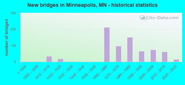
- New bridges - historical statistics
- 3Before 1900
- 41900-1909
- 351910-1919
- 201920-1929
- 41930-1939
- 11940-1949
- 2121960-1969
- 981970-1979
- 1521980-1989
- 671990-1999
- 752000-2009
- 622010-2019
- 152020-2022
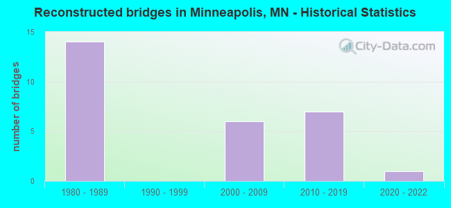
- Reconstructed bridges - Historical Statistics
- 141980-1989
- 01990-1999
- 62000-2009
- 72010-2019
- 12020-2022
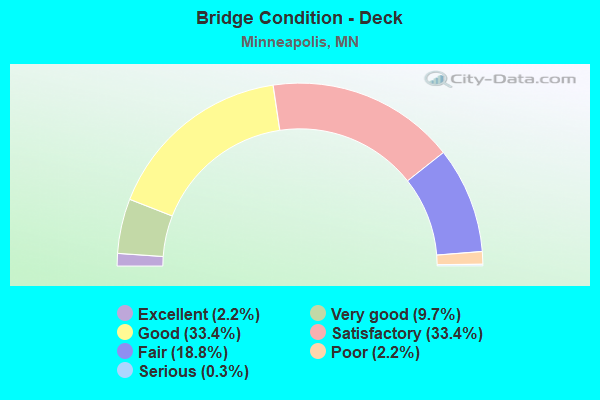
- Bridge Condition - Deck
- 2.2%Excellent
- 9.7%Very good
- 33.4%Good
- 33.4%Satisfactory
- 18.8%Fair
- 2.2%Poor
- 0.3%Serious
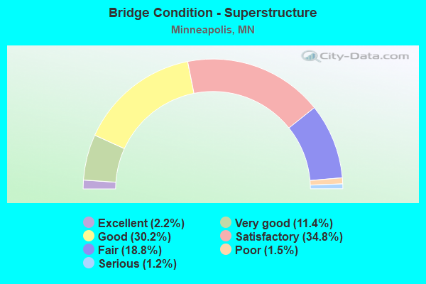
- Bridge Condition - Superstructure
- 2.2%Excellent
- 11.4%Very good
- 30.2%Good
- 34.8%Satisfactory
- 18.8%Fair
- 1.5%Poor
- 1.2%Serious
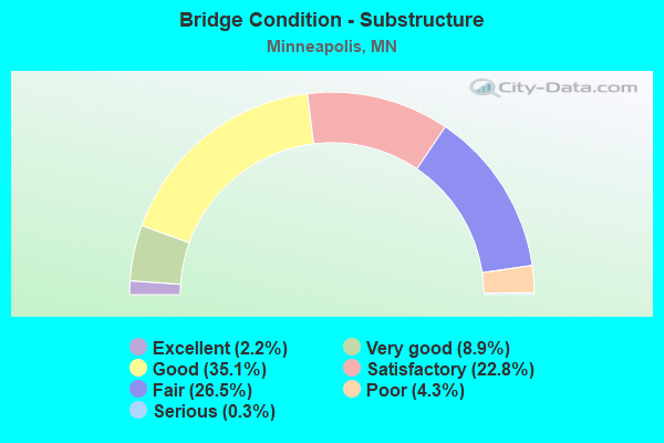
- Bridge Condition - Substructure
- 2.2%Excellent
- 8.9%Very good
- 35.1%Good
- 22.8%Satisfactory
- 26.5%Fair
- 4.3%Poor
- 0.3%Serious
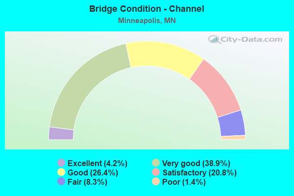
- Bridge Condition - Channel
- 4.2%Excellent
- 38.9%Very good
- 26.4%Good
- 20.8%Satisfactory
- 8.3%Fair
- 1.4%Poor
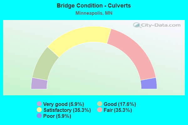
- Bridge Condition - Culverts
- 5.9%Very good
- 17.6%Good
- 35.3%Satisfactory
- 35.3%Fair
- 5.9%Poor
Find on map >> Show street view
Structure Number: 27B5, Location: 1.2 MI N OF JCT TH 94 (Lat: 44.980703, Lng: -93.276528), Route carried "under" structure: Interstate 394, Year Built: 2010, Structure Length: 0. m, Average Daily Traffic: 18,250 (year 2019), Truck Traffic: 4%, Features Intersected: I 394, 2ND AVE; RAMPS, Facility Carried by Structure: PEDESTRIAN
Minimum Vertical Clearance: 8.53m (27.99ft), Kilometerpoint: 0.116, Lanes under structure: 1, Material/Design: Prestressed concrete, Design/Construction: Stringer/Multi-beam, Length of Maximum Span: 30.2m (99.1ft)
Find on map >> Show street view
Structure Number: 27B63, Location: 0.38 M N OF JCT I94 (Lat: 44.970944, Lng: -93.252153), Route carried "under" structure: Ramp Interstate 3331, Year Built: 2013, Structure Length: 0. m, Average Daily Traffic: 1 (year 2019), Features Intersected: I35W, Facility Carried by Structure: RAILROAD
Minimum Vertical Clearance: 5.27m (17.29ft), Kilometerpoint: 0.000, Lanes under structure: 2, Material/Design: Prestressed concrete, Design/Construction: Stringer/Multi-beam, Length of Maximum Span: 30.8m (101.0ft)
Find on map >> Show street view
Structure Number: 27B63, Location: 0.38 M N OF JCT I94 (Lat: 44.970944, Lng: -93.252153), Route carried "under" structure: Ramp Interstate 1365, Year Built: 2013, Structure Length: 0. m, Average Daily Traffic: 18,300 (year 2012), Features Intersected: I35W, Facility Carried by Structure: RAILROAD
Minimum Vertical Clearance: 5.33m (17.49ft), Kilometerpoint: 0.000, Lanes under structure: 3, Material/Design: Prestressed concrete, Design/Construction: Stringer/Multi-beam, Length of Maximum Span: 30.8m (101.0ft)
Find on map >> Show street view
Structure Number: 27B63, Location: 0.38 M N OF JCT I94 (Lat: 44.970944, Lng: -93.252153), Route carried "under" structure: Ramp Interstate 4249, Year Built: 2013, Structure Length: 0. m, Average Daily Traffic: 8,300 (year 2011), Features Intersected: I35W, Facility Carried by Structure: RAILROAD
Minimum Vertical Clearance: 5.33m (17.49ft), Kilometerpoint: 0.000, Lanes under structure: 3, Material/Design: Prestressed concrete, Design/Construction: Stringer/Multi-beam, Length of Maximum Span: 30.8m (101.0ft)
Find on map >> Show street view
Structure Number: 27B63, Location: 0.38 M N OF JCT I94 (Lat: 44.970944, Lng: -93.252153), Route carried "under" structure: Interstate 35W, Year Built: 2013, Structure Length: 0. m, Average Daily Traffic: 127,000 (year 2019), Truck Traffic: 4%, Features Intersected: I35W, Facility Carried by Structure: RAILROAD
Minimum Vertical Clearance: 5.24m (17.19ft), Kilometerpoint: 0.000, Lanes under structure: 8, Material/Design: Prestressed concrete, Design/Construction: Stringer/Multi-beam, Length of Maximum Span: 30.8m (101.0ft)
Find on map >> Show street view
Structure Number: 27B84, Location: 0.3 MI W OF COUNTY LINE (Lat: 44.919014, Lng: -93.206542), Route carried "under" structure: City street 1203, Year Built: 2017, Structure Length: 0. m, Average Daily Traffic: 7,400 (year 2012), Features Intersected: GODFREY PARKWAY, Facility Carried by Structure: CSAH 46
Minimum Vertical Clearance: 4.45m (14.60ft), Kilometerpoint: 0.000, Lanes under structure: 2, Material/Design: Prestressed concrete, Design/Construction: Stringer/Multi-beam, Length of Maximum Span: 30.5m (100.1ft)
Find on map >> Show street view
Structure Number: 27R02, Location: AT THE JCT TH 62; 55 (Lat: 44.898561, Lng: -93.199861), Route carried "under" structure: State highway 62, Year Built: 2000, Structure Length: 0. m, Average Daily Traffic: 79,000 (year 2019), Truck Traffic: 5%, Features Intersected: TH 62; WB ON RMAP, Facility Carried by Structure: MN 55
Minimum Vertical Clearance: 6.22m (20.41ft), Kilometerpoint: 0.000, Lanes on structure: 5, Lanes under structure: 5, Material/Design: Steel continuous, Design/Construction: Stringer/Multi-beam, Length of Maximum Span: 41.3m (135.5ft)
Find on map >> Show street view
Structure Number: 27R02, Location: AT THE JCT TH 62; 55 (Lat: 44.898561, Lng: -93.199861), Route carried "under" structure: Ramp State highway 5867, Year Built: 2000, Structure Length: 0. m, Average Daily Traffic: 1 (year 2009), Features Intersected: TH 62; WB ON RMAP, Facility Carried by Structure: MN 55
Minimum Vertical Clearance: 4.97m (16.31ft), Kilometerpoint: 0.000, Lanes on structure: 5, Lanes under structure: 1, Material/Design: Steel continuous, Design/Construction: Stringer/Multi-beam, Length of Maximum Span: 41.3m (135.5ft)
Find on map >> Show street view
Structure Number: 27V25, Location: .1 MI W OF JCT TH 35W (Lat: 44.966614, Lng: -93.272689), Route carried "under" structure: Interstate 94, Year Built: 2000, Structure Length: 0. m, Average Daily Traffic: 145,290 (year 2019), Truck Traffic: 4%, Features Intersected: I 94; WB ON RAMP, Facility Carried by Structure: MSAS 305
Minimum Vertical Clearance: 5.03m (16.50ft), Kilometerpoint: 0.000, Lanes on structure: 2, Lanes under structure: 8, Material/Design: Steel continuous, Design/Construction: Stringer/Multi-beam, Length of Maximum Span: 29.4m (96.5ft)
Find on map >> Show street view
Structure Number: 27V25, Location: .1 MI W OF JCT TH 35W (Lat: 44.966614, Lng: -93.272689), Route carried "under" structure: Ramp State highway 2683, Year Built: 2000, Structure Length: 0. m, Average Daily Traffic: 1 (year 2009), Features Intersected: I 94; WB ON RAMP, Facility Carried by Structure: MSAS 305
Minimum Vertical Clearance: 5.00m (16.40ft), Kilometerpoint: 0.000, Lanes on structure: 2, Lanes under structure: 2, Material/Design: Steel continuous, Design/Construction: Stringer/Multi-beam, Length of Maximum Span: 29.4m (96.5ft)
Find on map >> Show street view
Structure Number: 27V28, Location: AT THE JCT TH 35W (Lat: 44.965883, Lng: -93.249681), Route carried "under" structure: City street 2375, Year Built: 2000, Structure Length: 0. m, Average Daily Traffic: 250 (year 1974), Features Intersected: LRT; FRONT ROAD, Facility Carried by Structure: CON 4293
Minimum Vertical Clearance: 6.22m (20.41ft), Kilometerpoint: 0.000, Lanes on structure: 1, Lanes under structure: 2, Material/Design: Steel continuous, Design/Construction: Stringer/Multi-beam, Length of Maximum Span: 29.5m (96.8ft)
Find on map >> Show street view
Structure Number: 27V75, Location: RAMP OVER NICOLLET AVE (Lat: 44.890781, Lng: -93.278100), Route carried "under" structure: County highway 52, Year Built: 2008, Structure Length: 0. m, Average Daily Traffic: 1 (year 2009), Features Intersected: NICOLLET AVE SO, Facility Carried by Structure: CON 76
Minimum Vertical Clearance: 9.94m (32.61ft), Kilometerpoint: 0.000, Lanes on structure: 2, Lanes under structure: 4, Material/Design: Prestressed concrete continuous, Design/Construction: Segmental Box Girder, Length of Maximum Span: 61.0m (200.1ft)
Find on map >> Show street view
Structure Number: 27V76, Location: AT THE E JCT MN 62; 35W (Lat: 44.890906, Lng: -93.275828), Route carried "under" structure: Interstate 35W, Year Built: 2008, Structure Length: 0. m, Average Daily Traffic: 98,000 (year 2019), Truck Traffic: 4%, Features Intersected: I 35W; NICOLLET AVE S, Facility Carried by Structure: MN 62
Minimum Vertical Clearance: 5.09m (16.70ft), Kilometerpoint: 0.000, Lanes on structure: 2, Lanes under structure: 7, Material/Design: Prestressed concrete continuous, Design/Construction: Segmental Box Girder, Length of Maximum Span: 57.9m (190.0ft)
Find on map >> Show street view
Structure Number: 27V76, Location: AT THE E JCT MN 62; 35W (Lat: 44.890906, Lng: -93.275828), Route carried "under" structure: County highway 52, Year Built: 2008, Structure Length: 0. m, Average Daily Traffic: 1 (year 2009), Features Intersected: I 35W; NICOLLET AVE S, Facility Carried by Structure: MN 62
Minimum Vertical Clearance: 10.49m (34.42ft), Kilometerpoint: 0.000, Lanes on structure: 2, Lanes under structure: 4, Material/Design: Prestressed concrete continuous, Design/Construction: Segmental Box Girder, Length of Maximum Span: 57.9m (190.0ft)
Find on map >> Show street view
Structure Number: 27V79, Location: AT E JCT OF TH 62; 35W (Lat: 44.890767, Lng: -93.274558), Route carried "under" structure: State highway 62, Year Built: 2008, Structure Length: 0. m, Average Daily Traffic: 72,000 (year 2019), Truck Traffic: 2%, Features Intersected: I 35W, MN 62 WB, Facility Carried by Structure: CON 6315
Minimum Vertical Clearance: 5.46m (17.91ft), Kilometerpoint: 0.000, Lanes on structure: 2, Lanes under structure: 4, Material/Design: Prestressed concrete continuous, Design/Construction: Segmental Box Girder, Length of Maximum Span: 54.9m (180.1ft)
Find on map >> Show street view
Structure Number: 27V79, Location: AT E JCT OF TH 62; 35W (Lat: 44.890767, Lng: -93.274558), Route carried "under" structure: Interstate 35W, Year Built: 2008, Structure Length: 0. m, Average Daily Traffic: 98,000 (year 2019), Truck Traffic: 4%, Features Intersected: I 35W, MN 62 WB, Facility Carried by Structure: CON 6315
Minimum Vertical Clearance: 11.40m (37.40ft), Kilometerpoint: 0.000, Lanes on structure: 2, Lanes under structure: 7, Material/Design: Prestressed concrete continuous, Design/Construction: Segmental Box Girder, Length of Maximum Span: 54.9m (180.1ft)
Find on map >> Show street view
Structure Number: 27V8, Location: 0.2 MI N OF E JCT 35W (Lat: 44.894275, Lng: -93.275397), Route carried "under" structure: City street 271, Year Built: 2008, Structure Length: 0. m, Average Daily Traffic: 1 (year 2009), Features Intersected: E 60 ST (MSAS 271), Facility Carried by Structure: CON 76
Minimum Vertical Clearance: 5.06m (16.60ft), Kilometerpoint: 0.000, Lanes on structure: 3, Lanes under structure: 4, Material/Design: Prestressed concrete, Design/Construction: Stringer/Multi-beam, Length of Maximum Span: 26.3m (86.3ft)
Find on map >> Show street view
Structure Number: 27V81, Location: 0.2 MI N OF E JCT 62; 35W (Lat: 44.894292, Lng: -93.274856), Route carried "under" structure: City street 271, Year Built: 2008, Structure Length: 0. m, Average Daily Traffic: 1 (year 2009), Features Intersected: E 60 ST (MSAS 271), Facility Carried by Structure: I 35W
Minimum Vertical Clearance: 5.55m (18.21ft), Kilometerpoint: 0.000, Lanes on structure: 9, Lanes under structure: 4, Material/Design: Prestressed concrete, Design/Construction: Stringer/Multi-beam, Length of Maximum Span: 27.9m (91.5ft)
Find on map >> Show street view
Structure Number: 27V84, Location: 0.39 MI N OF JCT MN 62 (Lat: 44.903542, Lng: -93.274911), Route carried "under" structure: Interstate 35W, Year Built: 2007, Structure Length: 0. m, Average Daily Traffic: 128,000 (year 2019), Truck Traffic: 4%, Features Intersected: I 35W, Facility Carried by Structure: MSAS 167
Minimum Vertical Clearance: 5.00m (16.40ft), Kilometerpoint: 0.000, Lanes on structure: 4, Lanes under structure: 10, Material/Design: Steel continuous, Design/Construction: Stringer/Multi-beam, Length of Maximum Span: 31.1m (102.0ft)
Find on map >> Show street view
Structure Number: 27V85, Location: 0.1 MI W OF E JCT MN 62 (Lat: 44.890397, Lng: -93.278089), Route carried "under" structure: County highway 52, Year Built: 2008, Structure Length: 0. m, Average Daily Traffic: 12,600 (year 2005), Features Intersected: NICOLLET AVE SO(CSAH 52), Facility Carried by Structure: I 35W
Minimum Vertical Clearance: 5.06m (16.60ft), Kilometerpoint: 0.000, Lanes on structure: 3, Lanes under structure: 4, Material/Design: Prestressed concrete, Design/Construction: Stringer/Multi-beam, Length of Maximum Span: 27.5m (90.2ft)
Find on map >> Show street view
Structure Number: 27V87, Location: 1.5 MI N OF JCT MN 62 (Lat: 44.912483, Lng: -93.274819), Route carried "under" structure: Interstate 35W, Year Built: 2007, Structure Length: 0. m, Average Daily Traffic: 133,000 (year 2019), Truck Traffic: 4%, Features Intersected: I 35W, Facility Carried by Structure: MSAS 264
Minimum Vertical Clearance: 4.54m (14.90ft), Kilometerpoint: 0.000, Lanes on structure: 3, Lanes under structure: 10, Material/Design: Steel continuous, Design/Construction: Stringer/Multi-beam, Length of Maximum Span: 31.0m (101.7ft)
Find on map >> Show street view
Structure Number: 27V88, Location: 2.0 MI N OF JCT MN 62 (Lat: 44.919636, Lng: -93.274742), Route carried "under" structure: Interstate 35W, Year Built: 2008, Structure Length: 0. m, Average Daily Traffic: 133,000 (year 2019), Truck Traffic: 4%, Features Intersected: I 35W, Facility Carried by Structure: CSAH 46
Minimum Vertical Clearance: 5.61m (18.41ft), Kilometerpoint: 0.000, Lanes on structure: 4, Lanes under structure: 10, Material/Design: Prestressed concrete, Design/Construction: Stringer/Multi-beam, Length of Maximum Span: 29.8m (97.8ft)
Find on map >> Show street view
Structure Number: 27W02, Location: 1.2 MI S OF JCT TH 94 (Lat: 44.951953, Lng: -93.273317), Route carried "under" structure: Interstate 35W, Year Built: 2018, Structure Length: 0. m, Average Daily Traffic: 179,358 (year 2019), Truck Traffic: 4%, Features Intersected: I 35W, Facility Carried by Structure: MSAS 241
Minimum Vertical Clearance: 6.04m (19.82ft), Kilometerpoint: 0.000, Lanes under structure: 10, Material/Design: Steel continuous, Design/Construction: Stringer/Multi-beam, Length of Maximum Span: 40.2m (131.9ft)
Find on map >> Show street view
Structure Number: 27W03, Location: 0.9 MI S OF JCT TH 94 (Lat: 44.955544, Lng: -93.270386), Route carried "under" structure: Interstate 35W, Year Built: 2018, Structure Length: 0. m, Average Daily Traffic: 179,358 (year 2019), Truck Traffic: 4%, Features Intersected: I 35W, Facility Carried by Structure: MSAS 239
Minimum Vertical Clearance: 6.83m (22.41ft), Kilometerpoint: 0.000, Lanes under structure: 11, Material/Design: Prestressed concrete, Design/Construction: Stringer/Multi-beam, Length of Maximum Span: 35.1m (115.2ft)
Find on map >> Show street view
Structure Number: 27W04, Location: 0.4 MI S OF TH 65; I 94 (Lat: 44.959100, Lng: -93.269700), Route carried "under" structure: Interstate 35W, Year Built: 2021, Structure Length: 0. m, Average Daily Traffic: 98,000 (year 2019), Truck Traffic: 3%, Features Intersected: I 35W, Facility Carried by Structure: PEDESTRIAN
Minimum Vertical Clearance: 5.33m (17.49ft), Kilometerpoint: 0.000, Lanes under structure: 12, Material/Design: Prestressed concrete, Design/Construction: Stringer/Multi-beam, Length of Maximum Span: 44.0m (144.4ft)
Find on map >> Show street view
Structure Number: 27W05, Location: 0.7 MI S OF JCT TH 94 (Lat: 44.964583, Lng: -93.269636), Route carried "under" structure: Interstate 94, Year Built: 2018, Structure Length: 0. m, Average Daily Traffic: 145,290 (year 2019), Truck Traffic: 4%, Features Intersected: I 35W SB, Facility Carried by Structure: MN 65
Minimum Vertical Clearance: 5.06m (16.60ft), Kilometerpoint: 0.000, Lanes under structure: 3, Material/Design: Prestressed concrete, Design/Construction: Stringer/Multi-beam, Length of Maximum Span: 37.5m (123.0ft)
Find on map >> Show street view
Structure Number: 27W06, Location: 0.2 MI S OF JCT TH 94 (Lat: 44.962711, Lng: -93.269486), Route carried "under" structure: Interstate 35W, Year Built: 2018, Structure Length: 0. m, Average Daily Traffic: 95,000 (year 2019), Truck Traffic: 4%, Features Intersected: I 35W; TH 65, Facility Carried by Structure: CSAH 5
Minimum Vertical Clearance: 5.03m (16.50ft), Kilometerpoint: 0.000, Lanes under structure: 5, Material/Design: Prestressed concrete, Design/Construction: Stringer/Multi-beam, Length of Maximum Span: 23.1m (75.8ft)
Find on map >> Show street view
Structure Number: 27W06, Location: 0.2 MI S OF JCT TH 94 (Lat: 44.962711, Lng: -93.269486), Route carried "under" structure: State highway 65, Year Built: 2018, Structure Length: 0. m, Average Daily Traffic: 76,000 (year 2019), Truck Traffic: 3%, Features Intersected: I 35W; TH 65, Facility Carried by Structure: CSAH 5
Minimum Vertical Clearance: 5.03m (16.50ft), Kilometerpoint: 0.000, Lanes under structure: 6, Material/Design: Prestressed concrete, Design/Construction: Stringer/Multi-beam, Length of Maximum Span: 23.1m (75.8ft)
Find on map >> Show street view
Structure Number: 27W07, Location: AT THE JCT OF I 94;MN 65 (Lat: 44.966100, Lng: -93.269400), Route carried "under" structure: Interstate 35W, Year Built: 2021, Structure Length: 0. m, Average Daily Traffic: 10,000 (year 2021), Truck Traffic: 4%, Features Intersected: I 35W SB;MN 65, Facility Carried by Structure: CON 4472
Minimum Vertical Clearance: 6.92m (22.70ft), Kilometerpoint: 0.000, Lanes under structure: 3, Material/Design: Steel continuous, Design/Construction: Stringer/Multi-beam, Length of Maximum Span: 54.9m (180.1ft)
Find on map >> Show street view
Structure Number: 27W07, Location: AT THE JCT OF I 94;MN 65 (Lat: 44.966100, Lng: -93.269400), Route carried "under" structure: State highway 65, Year Built: 2021, Structure Length: 0. m, Average Daily Traffic: 41,082 (year 2019), Truck Traffic: 3%, Features Intersected: I 35W SB;MN 65, Facility Carried by Structure: CON 4472
Minimum Vertical Clearance: 5.94m (19.49ft), Kilometerpoint: 0.000, Lanes under structure: 5, Material/Design: Steel continuous, Design/Construction: Stringer/Multi-beam, Length of Maximum Span: 54.9m (180.1ft)
Find on map >> Show street view
Structure Number: 27W27, Location: .2MI N OF JCT TH94 (Lat: 44.969014, Lng: -93.253303), Route carried "under" structure: Ramp Interstate 2672, Year Built: 2015, Structure Length: 0. m, Average Daily Traffic: 6,370 (year 1994), Features Intersected: I35W, RAMPS, 6TH ST, Facility Carried by Structure: CON 2017
Minimum Vertical Clearance: 9.30m (30.51ft), Kilometerpoint: 0.000, Lanes under structure: 2, Material/Design: Prestressed concrete, Design/Construction: Stringer/Multi-beam, Length of Maximum Span: 43.9m (144.0ft)
Find on map >> Show street view
Structure Number: 27W27, Location: .2MI N OF JCT TH94 (Lat: 44.969014, Lng: -93.253303), Route carried "under" structure: Ramp Interstate 5483, Year Built: 2015, Structure Length: 0. m, Average Daily Traffic: 10,000 (year 1994), Features Intersected: I35W, RAMPS, 6TH ST, Facility Carried by Structure: CON 2017
Minimum Vertical Clearance: 8.35m (27.40ft), Kilometerpoint: 0.000, Lanes under structure: 2, Material/Design: Prestressed concrete, Design/Construction: Stringer/Multi-beam, Length of Maximum Span: 43.9m (144.0ft)
Find on map >> Show street view
Structure Number: 27W27, Location: .2MI N OF JCT TH94 (Lat: 44.969014, Lng: -93.253303), Route carried "under" structure: Ramp Interstate 3331, Year Built: 2015, Structure Length: 0. m, Average Daily Traffic: 1 (year 2016), Features Intersected: I35W, RAMPS, 6TH ST, Facility Carried by Structure: CON 2017
Minimum Vertical Clearance: 7.93m (26.02ft), Kilometerpoint: 0.000, Lanes under structure: 3, Material/Design: Prestressed concrete, Design/Construction: Stringer/Multi-beam, Length of Maximum Span: 43.9m (144.0ft)
Find on map >> Show street view
Structure Number: 27W27, Location: .2MI N OF JCT TH94 (Lat: 44.969014, Lng: -93.253303), Route carried "under" structure: Ramp Interstate 576, Year Built: 2015, Structure Length: 0. m, Average Daily Traffic: 1 (year 2016), Features Intersected: I35W, RAMPS, 6TH ST, Facility Carried by Structure: CON 2017
Minimum Vertical Clearance: 10.85m (35.60ft), Kilometerpoint: 0.000, Lanes under structure: 3, Material/Design: Prestressed concrete, Design/Construction: Stringer/Multi-beam, Length of Maximum Span: 43.9m (144.0ft)
Find on map >> Show street view
Structure Number: 27W27, Location: .2MI N OF JCT TH94 (Lat: 44.969014, Lng: -93.253303), Route carried "under" structure: Ramp Interstate 4293, Year Built: 2015, Structure Length: 0. m, Average Daily Traffic: 1 (year 2016), Features Intersected: I35W, RAMPS, 6TH ST, Facility Carried by Structure: CON 2017
Minimum Vertical Clearance: 5.36m (17.59ft), Kilometerpoint: 0.000, Lanes under structure: 3, Material/Design: Prestressed concrete, Design/Construction: Stringer/Multi-beam, Length of Maximum Span: 43.9m (144.0ft)
Find on map >> Show street view
Structure Number: 27W27, Location: .2MI N OF JCT TH94 (Lat: 44.969014, Lng: -93.253303), Route carried "under" structure: Interstate 35W, Year Built: 2015, Structure Length: 0. m, Average Daily Traffic: 114,000 (year 2019), Truck Traffic: 4%, Features Intersected: I35W, RAMPS, 6TH ST, Facility Carried by Structure: CON 2017
Minimum Vertical Clearance: 9.60m (31.50ft), Kilometerpoint: 0.000, Lanes under structure: 4, Material/Design: Prestressed concrete, Design/Construction: Stringer/Multi-beam, Length of Maximum Span: 43.9m (144.0ft)
Find on map >> Show street view
Structure Number: 27W41, Location: 1.3 MI NE OF JCT I 94 (Lat: 44.984817, Lng: -93.241539), Route carried "under" structure: Interstate 35W, Year Built: 2019, Structure Length: 0. m, Average Daily Traffic: 117,000 (year 2019), Truck Traffic: 4%, Features Intersected: I 35W, Facility Carried by Structure: PEDESTRIAN
Minimum Vertical Clearance: 5.61m (18.41ft), Kilometerpoint: 0.000, Lanes under structure: 7, Material/Design: Steel, Design/Construction: Truss - Thru, Length of Maximum Span: 60.2m (197.5ft)
Find on map >> Show street view
Structure Number: 27W41, Location: 1.3 MI NE OF JCT I 94 (Lat: 44.984817, Lng: -93.241539), Route carried "under" structure: Ramp Interstate 1947, Year Built: 2019, Structure Length: 0. m, Average Daily Traffic: 1 (year 2017), Features Intersected: I 35W, Facility Carried by Structure: PEDESTRIAN
Minimum Vertical Clearance: 5.40m (17.72ft), Kilometerpoint: 0.000, Lanes under structure: 1, Material/Design: Steel, Design/Construction: Truss - Thru, Length of Maximum Span: 60.2m (197.5ft)
Find on map >> Show street view
Structure Number: 27W41, Location: 1.3 MI NE OF JCT I 94 (Lat: 44.984817, Lng: -93.241539), Route carried "under" structure: Ramp Interstate 5941, Year Built: 2019, Structure Length: 0. m, Average Daily Traffic: 1 (year 2017), Features Intersected: I 35W, Facility Carried by Structure: PEDESTRIAN
Minimum Vertical Clearance: 5.61m (18.41ft), Kilometerpoint: 0.000, Lanes under structure: 1, Material/Design: Steel, Design/Construction: Truss - Thru, Length of Maximum Span: 60.2m (197.5ft)
Find on map >> Show street view
Structure Number: 62082, Location: AT RAMSEY; HENN CO LINE (Lat: 44.948414, Lng: -93.202278), Route carried "under" structure: City street 166, Year Built: 1989, Structure Length: 0. m, Average Daily Traffic: 6,400 (year 2005), Features Intersected: MISSISSIPPI R; CITY STS, Facility Carried by Structure: CSAH 3
Minimum Vertical Clearance: 5.27m (17.29ft), Kilometerpoint: 0.000, Lanes on structure: 4, Lanes under structure: 2, Material/Design: Concrete, Design/Construction: Arch - Deck, Length of Maximum Span: 169.3m (555.4ft)
Find on map >> Show street view
Structure Number: 62082, Location: AT RAMSEY; HENN CO LINE (Lat: 44.948414, Lng: -93.202278), Route carried "under" structure: City street 701, Year Built: 1989, Structure Length: 0. m, Average Daily Traffic: 3,850 (year 1993), Features Intersected: MISSISSIPPI R; CITY STS, Facility Carried by Structure: CSAH 3
Minimum Vertical Clearance: 4.72m (15.49ft), Kilometerpoint: 0.000, Lanes on structure: 4, Lanes under structure: 2, Material/Design: Concrete, Design/Construction: Arch - Deck, Length of Maximum Span: 169.3m (555.4ft)
Find on map >> Show street view
Structure Number: 7269, Location: 0.4 MI E OF E JCT TH 35W (Lat: 44.890694, Lng: -93.267844), Route carried "under" structure: State highway 62, Year Built: 1963, Structure Length: 0. m, Average Daily Traffic: 95,000 (year 2019), Truck Traffic: 3%, Features Intersected: TH 62, Facility Carried by Structure: CSAH 35
Minimum Vertical Clearance: 4.57m (14.99ft), Kilometerpoint: 0.000, Lanes on structure: 4, Lanes under structure: 4, Material/Design: Steel continuous, Design/Construction: Stringer/Multi-beam, Length of Maximum Span: 22.6m (74.1ft)
Find on map >> Show street view
Structure Number: 90591, Location: 1.7 MI N OF JCT CSAH 53 (Lat: 44.907600, Lng: -93.278083), Route carried "under" structure: City street 1025, Year Built: 1923, Structure Length: 0. m, Average Daily Traffic: 8,900 (year 2002), Features Intersected: MINNEHAHA PKWY; CREEK, Facility Carried by Structure: MSAS 430
Minimum Vertical Clearance: 4.69m (15.39ft), Kilometerpoint: 0.000, Lanes on structure: 4, Lanes under structure: 1, Material/Design: Concrete, Design/Construction: Arch - Deck, Length of Maximum Span: 28.5m (93.5ft)
Find on map >> Show street view
Structure Number: 90591, Location: 1.7 MI N OF JCT CSAH 53 (Lat: 44.907600, Lng: -93.278083), Route carried "under" structure: City street 1067, Year Built: 1923, Structure Length: 0. m, Average Daily Traffic: 8,900 (year 2002), Features Intersected: MINNEHAHA PKWY; CREEK, Facility Carried by Structure: MSAS 430
Minimum Vertical Clearance: 5.49m (18.01ft), Kilometerpoint: 0.000, Lanes on structure: 4, Lanes under structure: 1, Material/Design: Concrete, Design/Construction: Arch - Deck, Length of Maximum Span: 28.5m (93.5ft)
Find on map >> Show street view
Structure Number: 935, Location: 1.3 MI SE OF JCT TH 55 (Lat: 44.966167, Lng: -93.225936), Route carried "under" structure: City street 701, Year Built: 1963, Structure Length: 0. m, Average Daily Traffic: 5,800 (year 1997), Features Intersected: MISS R, ramp, W River Rd, Facility Carried by Structure: I 94
Minimum Vertical Clearance: 19.48m (63.91ft), Kilometerpoint: 0.000, Lanes on structure: 8, Lanes under structure: 2, Material/Design: Steel continuous, Design/Construction: Stringer/Multi-beam, Length of Maximum Span: 103.7m (340.2ft)
Find on map >> Show street view
Structure Number: 935, Location: 1.3 MI SE OF JCT TH 55 (Lat: 44.966167, Lng: -93.225936), Route carried "under" structure: Ramp Interstate 85, Year Built: 1963, Structure Length: 0. m, Average Daily Traffic: 500 (year 1974), Features Intersected: MISS R, ramp, W River Rd, Facility Carried by Structure: I 94
Minimum Vertical Clearance: 18.26m (59.91ft), Kilometerpoint: 0.000, Lanes on structure: 8, Lanes under structure: 2, Material/Design: Steel continuous, Design/Construction: Stringer/Multi-beam, Length of Maximum Span: 103.7m (340.2ft)
Find on map >> Show street view
Structure Number: 936, Location: 0.6 MI E OF JCT TH 35W (Lat: 44.973525, Lng: -93.237967), Route carried "under" structure: City street 513, Year Built: 1965, Structure Length: 0. m, Average Daily Traffic: 4,300 (year 1997), Features Intersected: MISS. RIVER; STREETS, Facility Carried by Structure: CSAH 122
Minimum Vertical Clearance: 4.76m (15.62ft), Kilometerpoint: 0.000, Lanes on structure: 4, Lanes under structure: 2, Material/Design: Steel continuous, Design/Construction: Girder and Floorbeam System, Length of Maximum Span: 96.1m (315.3ft)
Find on map >> Show street view
Structure Number: 936, Location: 0.6 MI E OF JCT TH 35W (Lat: 44.973525, Lng: -93.237967), Route carried "under" structure: City street 1863, Year Built: 1965, Structure Length: 0. m, Average Daily Traffic: 500 (year 1974), Features Intersected: MISS. RIVER; STREETS, Facility Carried by Structure: CSAH 122
Minimum Vertical Clearance: 5.49m (18.01ft), Kilometerpoint: 0.000, Lanes on structure: 4, Lanes under structure: 2, Material/Design: Steel continuous, Design/Construction: Girder and Floorbeam System, Length of Maximum Span: 96.1m (315.3ft)
Find on map >> Show street view
Structure Number: 942, Location: 0.8 MI SE OF JCT TH 55 (Lat: 44.964322, Lng: -93.236161), Route carried "under" structure: Interstate 94, Year Built: 1962, Structure Length: 0. m, Average Daily Traffic: 160,000 (year 2019), Truck Traffic: 4%, Features Intersected: I 94, Facility Carried by Structure: MSAS 429
Minimum Vertical Clearance: 4.51m (14.80ft), Kilometerpoint: 0.000, Lanes on structure: 4, Lanes under structure: 6, Material/Design: Steel continuous, Design/Construction: Stringer/Multi-beam, Length of Maximum Span: 18.0m (59.1ft)
Find on map >> Show street view
Structure Number: 9421, Location: 0.9 MI SE OF JCT TH 55 (Lat: 44.964353, Lng: -93.233383), Route carried "under" structure: Interstate 94, Year Built: 1962, Structure Length: 0. m, Average Daily Traffic: 160,000 (year 2019), Truck Traffic: 4%, Features Intersected: I 94, Facility Carried by Structure: MSAS 198
Minimum Vertical Clearance: 4.51m (14.80ft), Kilometerpoint: 0.000, Lanes on structure: 4, Lanes under structure: 6, Material/Design: Steel continuous, Design/Construction: Stringer/Multi-beam, Length of Maximum Span: 35.1m (115.2ft)
Find on map >> Show street view
Structure Number: 95892, Location: 0.1 MI S OF JCT TH55(7TH (Lat: 44.979953, Lng: -93.278297), Route carried "under" structure: Interstate 394, Year Built: 1988, Structure Length: 0. m, Average Daily Traffic: 18,250 (year 2019), Truck Traffic: 4%, Features Intersected: I 394, RAMPS; GLENWOOD, Facility Carried by Structure: PLAZA
Minimum Vertical Clearance: 5.30m (17.39ft), Kilometerpoint: 0.000, Lanes on structure: 1, Lanes under structure: 11, Material/Design: Concrete, Design/Construction: Slab, Length of Maximum Span: 61.3m (201.1ft)
Find on map >> Show street view
Structure Number: 95892, Location: 0.1 MI S OF JCT TH55(7TH (Lat: 44.979953, Lng: -93.278297), Route carried "under" structure: County highway 40, Year Built: 1988, Structure Length: 0. m, Average Daily Traffic: 2,800 (year 2005), Features Intersected: I 394, RAMPS; GLENWOOD, Facility Carried by Structure: PLAZA
Minimum Vertical Clearance: 4.94m (16.21ft), Kilometerpoint: 0.000, Lanes on structure: 2, Lanes under structure: 11, Material/Design: Concrete, Design/Construction: Slab, Length of Maximum Span: 61.3m (201.1ft)
Find on map >> Show street view
Structure Number: 95892, Location: 0.1 MI S OF JCT TH55(7TH (Lat: 44.979953, Lng: -93.278297), Route carried "under" structure: Interstate 394, Year Built: 1988, Structure Length: 0. m, Average Daily Traffic: 18,250 (year 2019), Truck Traffic: 4%, Features Intersected: I 394, RAMPS; GLENWOOD, Facility Carried by Structure: PLAZA
Minimum Vertical Clearance: 5.61m (18.41ft), Kilometerpoint: 0.000, Lanes on structure: 1, Lanes under structure: 11, Material/Design: Concrete, Design/Construction: Slab, Length of Maximum Span: 61.3m (201.1ft)
Find on map >> Show street view
Structure Number: 95892, Location: 0.1 MI S OF JCT TH55(7TH (Lat: 44.979953, Lng: -93.278297), Route carried "under" structure: Interstate 394, Year Built: 1988, Structure Length: 0. m, Average Daily Traffic: 36,500 (year 2019), Truck Traffic: 4%, Features Intersected: I 394, RAMPS; GLENWOOD, Facility Carried by Structure: PLAZA
Minimum Vertical Clearance: 5.55m (18.21ft), Kilometerpoint: 0.000, Lanes on structure: 4, Lanes under structure: 11, Material/Design: Concrete, Design/Construction: Slab, Length of Maximum Span: 61.3m (201.1ft)
Find on map >> Show street view
Structure Number: 95892, Location: 0.1 MI S OF JCT TH55(7TH (Lat: 44.979953, Lng: -93.278297), Route carried "under" structure: Interstate 394, Year Built: 1988, Structure Length: 0. m, Average Daily Traffic: 18,250 (year 2019), Truck Traffic: 4%, Features Intersected: I 394, RAMPS; GLENWOOD, Facility Carried by Structure: PLAZA
Minimum Vertical Clearance: 5.15m (16.90ft), Kilometerpoint: 0.000, Lanes on structure: 1, Lanes under structure: 11, Material/Design: Concrete, Design/Construction: Slab, Length of Maximum Span: 61.3m (201.1ft)
Find on map >> Show street view
Structure Number: 95892, Location: 0.1 MI S OF JCT TH55(7TH (Lat: 44.979953, Lng: -93.278297), Route carried "under" structure: Interstate 394, Year Built: 1988, Structure Length: 0. m, Average Daily Traffic: 18,250 (year 2019), Truck Traffic: 4%, Features Intersected: I 394, RAMPS; GLENWOOD, Facility Carried by Structure: PLAZA
Minimum Vertical Clearance: 5.30m (17.39ft), Kilometerpoint: 0.000, Lanes on structure: 2, Lanes under structure: 11, Material/Design: Concrete, Design/Construction: Slab, Length of Maximum Span: 61.3m (201.1ft)
Find on map >> Show street view
Structure Number: 95893, Location: 0.8 MI NE OF JCT TH 94 (Lat: 44.980483, Lng: -93.276214), Route carried "under" structure: Interstate 394, Year Built: 1986, Structure Length: 0. m, Average Daily Traffic: 36,500 (year 2019), Truck Traffic: 4%, Features Intersected: 2ND AVE N, Facility Carried by Structure: SKYWAY
Minimum Vertical Clearance: 6.52m (21.39ft), Kilometerpoint: 0.000, Lanes on structure: 4, Lanes under structure: 13, Material/Design: Concrete, Design/Construction: Slab, Length of Maximum Span: 31.7m (104.0ft)
Find on map >> Show street view
Structure Number: 95893, Location: 0.8 MI NE OF JCT TH 94 (Lat: 44.980483, Lng: -93.276214), Route carried "under" structure: Ramp Interstate 7580, Year Built: 1986, Structure Length: 0. m, Average Daily Traffic: 1,000 (year 1994), Features Intersected: 2ND AVE N, Facility Carried by Structure: SKYWAY
Minimum Vertical Clearance: 6.52m (21.39ft), Kilometerpoint: 0.000, Lanes on structure: 1, Lanes under structure: 13, Material/Design: Concrete, Design/Construction: Slab, Length of Maximum Span: 31.7m (104.0ft)
Find on map >> Show street view
Structure Number: 95893, Location: 0.8 MI NE OF JCT TH 94 (Lat: 44.980483, Lng: -93.276214), Route carried "under" structure: Ramp Interstate 3053, Year Built: 1986, Structure Length: 0. m, Average Daily Traffic: 1,000 (year 1994), Features Intersected: 2ND AVE N, Facility Carried by Structure: SKYWAY
Minimum Vertical Clearance: 6.52m (21.39ft), Kilometerpoint: 0.000, Lanes on structure: 2, Lanes under structure: 13, Material/Design: Concrete, Design/Construction: Slab, Length of Maximum Span: 31.7m (104.0ft)
Find on map >> Show street view
Structure Number: 95893, Location: 0.8 MI NE OF JCT TH 94 (Lat: 44.980483, Lng: -93.276214), Route carried "under" structure: City street 208, Year Built: 1986, Structure Length: 0. m, Average Daily Traffic: 6,500 (year 2005), Features Intersected: 2ND AVE N, Facility Carried by Structure: SKYWAY
Minimum Vertical Clearance: 4.97m (16.31ft), Kilometerpoint: 0.000, Lanes on structure: 4, Lanes under structure: 13, Material/Design: Concrete, Design/Construction: Slab, Length of Maximum Span: 31.7m (104.0ft)
Find on map >> Show street view
Structure Number: 95893, Location: 0.8 MI NE OF JCT TH 94 (Lat: 44.980483, Lng: -93.276214), Route carried "under" structure: Ramp Interstate 1019, Year Built: 1986, Structure Length: 0. m, Average Daily Traffic: 1,000 (year 1994), Features Intersected: 2ND AVE N, Facility Carried by Structure: SKYWAY
Minimum Vertical Clearance: 6.52m (21.39ft), Kilometerpoint: 0.000, Lanes on structure: 2, Lanes under structure: 13, Material/Design: Concrete, Design/Construction: Slab, Length of Maximum Span: 31.7m (104.0ft)
Find on map >> Show street view
Structure Number: 95894, Location: Between 4th St. & 3rd St (Lat: 44.983000, Lng: -93.274383), Route carried "under" structure: Interstate 394, Year Built: 1990, Structure Length: 0. m, Average Daily Traffic: 10,000 (year 2004), Truck Traffic: 6%, Features Intersected: I 394 WB, ramps & 3rd Av, Facility Carried by Structure: PLAZA
Minimum Vertical Clearance: 5.06m (16.60ft), Kilometerpoint: 0.000, Lanes on structure: 2, Lanes under structure: 2, Material/Design: Concrete, Design/Construction: Slab, Length of Maximum Span: 19.2m (63.0ft)
Find on map >> Show street view
Structure Number: 95894, Location: Between 4th St. & 3rd St (Lat: 44.983000, Lng: -93.274383), Route carried "under" structure: Ramp Interstate 4897, Year Built: 1990, Structure Length: 0. m, Average Daily Traffic: 1,000 (year 1994), Features Intersected: I 394 WB, ramps & 3rd Av, Facility Carried by Structure: PLAZA
Minimum Vertical Clearance: 4.85m (15.91ft), Kilometerpoint: 0.000, Lanes on structure: 1, Lanes under structure: 1, Material/Design: Concrete, Design/Construction: Slab, Length of Maximum Span: 19.2m (63.0ft)
Find on map >> Show street view
Structure Number: 95894, Location: Between 4th St. & 3rd St (Lat: 44.983000, Lng: -93.274383), Route carried "under" structure: City street 209, Year Built: 1990, Structure Length: 0. m, Average Daily Traffic: 4,300 (year 2005), Features Intersected: I 394 WB, ramps & 3rd Av, Facility Carried by Structure: PLAZA
Minimum Vertical Clearance: 4.76m (15.62ft), Kilometerpoint: 0.000, Lanes on structure: 5, Lanes under structure: 5, Material/Design: Concrete, Design/Construction: Slab, Length of Maximum Span: 19.2m (63.0ft)
Find on map >> Show street view
Structure Number: 95894, Location: Between 4th St. & 3rd St (Lat: 44.983000, Lng: -93.274383), Route carried "under" structure: Other road , Year Built: 1990, Structure Length: 0. m, Average Daily Traffic: 1,000 (year 1994), Features Intersected: I 394 WB, ramps & 3rd Av, Facility Carried by Structure: PLAZA
Minimum Vertical Clearance: 7.50m (24.61ft), Kilometerpoint: 0.000, Lanes on structure: 1, Lanes under structure: 1, Material/Design: Concrete, Design/Construction: Slab, Length of Maximum Span: 19.2m (63.0ft)
Find on map >> Show street view
Structure Number: 95894, Location: Between 4th St. & 3rd St (Lat: 44.983000, Lng: -93.274383), Route carried "under" structure: City street 209, Year Built: 1990, Structure Length: 0. m, Average Daily Traffic: 1,000 (year 1994), Features Intersected: I 394 WB, ramps & 3rd Av, Facility Carried by Structure: PLAZA
Minimum Vertical Clearance: 4.79m (15.72ft), Kilometerpoint: 0.000, Lanes on structure: 1, Lanes under structure: 1, Material/Design: Concrete, Design/Construction: Slab, Length of Maximum Span: 19.2m (63.0ft)
Find on map >> Show street view
Structure Number: 95894, Location: Between 4th St. & 3rd St (Lat: 44.983000, Lng: -93.274383), Route carried "under" structure: Interstate 394, Year Built: 1990, Structure Length: 0. m, Average Daily Traffic: 18,250 (year 2019), Truck Traffic: 4%, Features Intersected: I 394 WB, ramps & 3rd Av, Facility Carried by Structure: PLAZA
Minimum Vertical Clearance: 6.80m (22.31ft), Kilometerpoint: 0.000, Lanes on structure: 1, Lanes under structure: 1, Material/Design: Concrete, Design/Construction: Slab, Length of Maximum Span: 19.2m (63.0ft)
Find on map >> Show street view
Structure Number: 9616, Location: 2.5 MI N OF JCT TH 62 (Lat: 44.926839, Lng: -93.274636), Route carried "under" structure: Interstate 35W, Year Built: 1964, Structure Length: 0. m, Average Daily Traffic: 161,322 (year 2019), Truck Traffic: 4%, Features Intersected: I 35W, Facility Carried by Structure: MSAS 260
Minimum Vertical Clearance: 4.97m (16.31ft), Kilometerpoint: 0.000, Lanes on structure: 4, Lanes under structure: 8, Material/Design: Prestressed concrete, Design/Construction: Stringer/Multi-beam, Length of Maximum Span: 21.8m (71.5ft)
Find on map >> Show street view
Structure Number: 9619, Location: 3.0 MI N OF JCT TH 62 (Lat: 44.934131, Lng: -93.274689), Route carried "under" structure: Interstate 35W, Year Built: 1961, Structure Length: 0. m, Average Daily Traffic: 161,322 (year 2019), Truck Traffic: 4%, Features Intersected: I 35W, Facility Carried by Structure: MSAS 253
Minimum Vertical Clearance: 4.91m (16.11ft), Kilometerpoint: 0.000, Lanes on structure: 2, Lanes under structure: 8, Material/Design: Prestressed concrete, Design/Construction: Stringer/Multi-beam, Length of Maximum Span: 23.7m (77.8ft)
Find on map >> Show street view
Structure Number: 962, Location: 3.2 MI N OF JCT TH 62 (Lat: 44.937736, Lng: -93.274686), Route carried "under" structure: Interstate 35W, Year Built: 1965, Structure Length: 0. m, Average Daily Traffic: 161,322 (year 2019), Truck Traffic: 4%, Features Intersected: I 35W, Facility Carried by Structure: MSAS 251
Minimum Vertical Clearance: 5.09m (16.70ft), Kilometerpoint: 0.000, Lanes on structure: 3, Lanes under structure: 8, Material/Design: Prestressed concrete, Design/Construction: Stringer/Multi-beam, Length of Maximum Span: 21.7m (71.2ft)
Find on map >> Show street view
Structure Number: 9621, Location: 3.3 MI N OF JCT TH 62 (Lat: 44.939525, Lng: -93.274694), Route carried "under" structure: Interstate 35W, Year Built: 1965, Structure Length: 0. m, Average Daily Traffic: 161,322 (year 2019), Truck Traffic: 4%, Features Intersected: I 35W, Facility Carried by Structure: MSAS 249
Minimum Vertical Clearance: 4.66m (15.29ft), Kilometerpoint: 0.000, Lanes on structure: 3, Lanes under structure: 8, Material/Design: Prestressed concrete, Design/Construction: Stringer/Multi-beam, Length of Maximum Span: 21.6m (70.9ft)
Find on map >> Show street view
Structure Number: 9892, Location: 0.6 MI SE OF JCT TH 55 (Lat: 44.964347, Lng: -93.240128), Route carried "under" structure: Interstate 94, Year Built: 1962, Structure Length: 0. m, Average Daily Traffic: 160,000 (year 2019), Truck Traffic: 4%, Features Intersected: I 94, Facility Carried by Structure: PEDESTRIAN
Minimum Vertical Clearance: 4.85m (15.91ft), Kilometerpoint: 0.000, Lanes on structure: 9, Lanes under structure: 9, Material/Design: Steel, Design/Construction: Stringer/Multi-beam, Length of Maximum Span: 28.1m (92.2ft)
Find on map >> Show street view
Structure Number: 9893, Location: 1.2 MI SE OF JCT TH 55 (Lat: 44.964786, Lng: -93.228897), Route carried "under" structure: City street 1485, Year Built: 1962, Structure Length: 0. m, Average Daily Traffic: 500 (year 1974), Features Intersected: Franklin Terrace, Facility Carried by Structure: I 94
Minimum Vertical Clearance: 4.51m (14.80ft), Kilometerpoint: 0.000, Lanes on structure: 8, Lanes under structure: 2, Material/Design: Concrete continuous, Design/Construction: Slab, Length of Maximum Span: 14.6m (47.9ft)
Find on map >> Show street view
Structure Number: R0834, Location: MSP INTL AIRPORT (Lat: 44.883169, Lng: -93.210750), Route carried "under" structure: ServiceOther road 11, Year Built: 1993, Structure Length: 0. m, Average Daily Traffic: 11,000 (year 2019), Features Intersected: TERMINAL ROAD 1, Facility Carried by Structure: AR 8
Minimum Vertical Clearance: 3.54m (11.61ft), Kilometerpoint: 0.000, Lanes under structure: 9, Material/Design: Steel, Design/Construction: Girder and Floorbeam System, Length of Maximum Span: 15.2m (49.9ft)