Bridge Statistics for Montgomery, Alabama (AL)
Condition, Traffic, Stress, Structural Evaluation, Project Costs
- National Bridge Inventory (NBI) Statistics
- 464Number of bridges
- 8,547ft / 2,605mTotal length
- $1,263,763,000Total costs
- 8,220,647Total average daily traffic
- 853,526Total average daily truck traffic
- National Bridge Inventory (NBI) Registered Bridges for Montgomery
- No street view available for this location
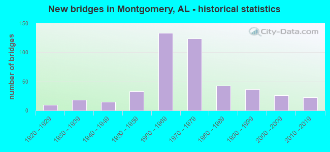
- New bridges - historical statistics
- 11910-1919
- 101920-1929
- 181930-1939
- 151940-1949
- 331950-1959
- 1331960-1969
- 1241970-1979
- 431980-1989
- 371990-1999
- 262000-2009
- 232010-2019
- 12020-2022
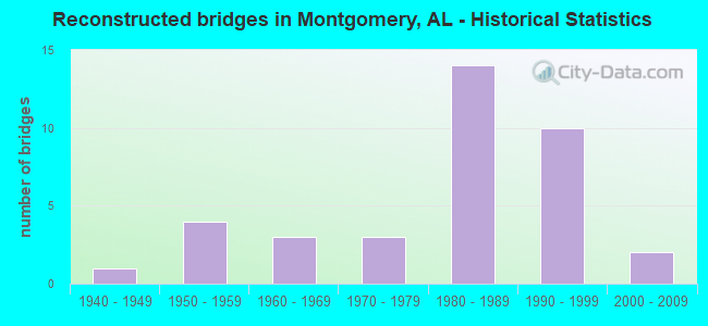
- Reconstructed bridges - Historical Statistics
- 11940-1949
- 41950-1959
- 31960-1969
- 31970-1979
- 141980-1989
- 101990-1999
- 22000-2009
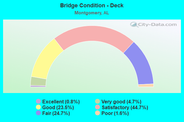
- Bridge Condition - Deck
- 0.8%Excellent
- 4.7%Very good
- 23.5%Good
- 44.7%Satisfactory
- 24.7%Fair
- 1.6%Poor
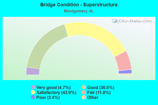
- Bridge Condition - Superstructure
- 4.7%Excellent
- 36.5%Very good
- 43.9%Good
- 11.8%Satisfactory
- 2.4%Fair
- 0.8%Poor
- 0.4%Serious
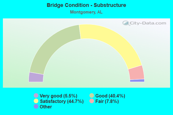
- Bridge Condition - Substructure
- 5.5%Excellent
- 40.4%Very good
- 44.7%Good
- 7.8%Satisfactory
- 1.6%Fair
- 0.8%Poor
- 0.4%Serious
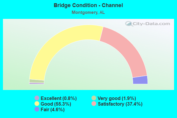
- Bridge Condition - Channel
- 0.8%Excellent
- 1.9%Very good
- 55.3%Good
- 37.4%Satisfactory
- 4.6%Fair
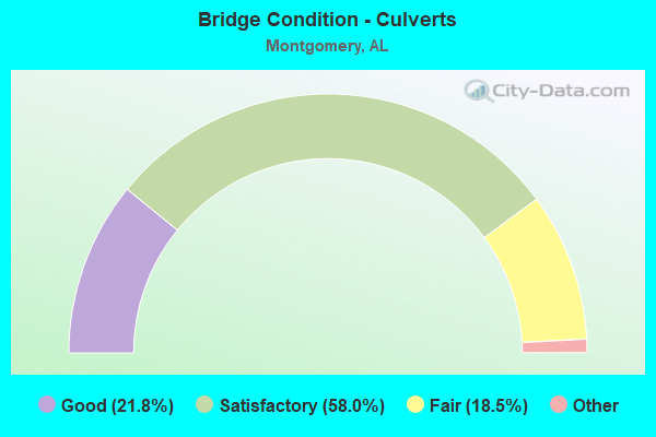
- Bridge Condition - Culverts
- 21.8%Excellent
- 58.0%Very good
- 18.5%Good
- 1.7%Satisfactory
- 18.5%Fair
Find on map >> Show street view
Structure Number: 10706, Location: 3.5 MI.N.OF AL.RIVER (Lat: 32.418017, Lng: -86.356850), Route carried "under" structure: State highway 143, Year Built: 1972, Structure Length: 0. m, Average Daily Traffic: 11,150 (year 2013), Truck Traffic: 6%, Features Intersected: AL.RIVER RLF.8 * AL 143, Facility Carried by Structure: I-65
Minimum Vertical Clearance: 4.60m (15.09ft), Kilometerpoint: 0.319, Lanes on structure: 6, Lanes under structure: 1, Material/Design: Concrete, Design/Construction: Tee Beam, Length of Maximum Span: 10.4m (34.1ft)
Find on map >> Show street view
Structure Number: 10804, Location: 3.1 MW US 231 (Lat: 32.424625, Lng: -86.283586), Route carried "under" structure: County highway 75, Year Built: 1972, Structure Length: 0. m, Average Daily Traffic: 13,070 (year 2003), Truck Traffic: 1%, Features Intersected: LOWER WETUMPKA RD, Facility Carried by Structure: AL 152
Minimum Vertical Clearance: 5.36m (17.59ft), Kilometerpoint: 5.399, Lanes on structure: 2, Lanes under structure: 4, Material/Design: Steel continuous, Design/Construction: Stringer/Multi-beam, Length of Maximum Span: 18.3m (60.0ft)
Find on map >> Show street view
Structure Number: 10805, Location: 3.1 M W US 231 (Lat: 32.424347, Lng: -86.284150), Route carried "under" structure: Bypass County highway 75, Year Built: 1972, Structure Length: 0. m, Average Daily Traffic: 13,070 (year 2003), Truck Traffic: 1%, Features Intersected: LOWER WETUMPKA RD, Facility Carried by Structure: AL 152
Minimum Vertical Clearance: 5.36m (17.59ft), Kilometerpoint: 5.238, Lanes on structure: 2, Lanes under structure: 4, Material/Design: Steel continuous, Design/Construction: Stringer/Multi-beam, Length of Maximum Span: 18.3m (60.0ft)
Find on map >> Show street view
Structure Number: 10806, Location: 3.8 MI W US 231 HWY (Lat: 32.418667, Lng: -86.292767), Route carried "under" structure: State highway 152, Year Built: 1972, Structure Length: 0. m, Average Daily Traffic: 22,417 (year 2013), Truck Traffic: 9%, Features Intersected: AL 152, Facility Carried by Structure: PEDESTRIAN OVERPAS
Minimum Vertical Clearance: 5.36m (17.59ft), Kilometerpoint: 4.511, Lanes under structure: 6, Material/Design: Steel, Design/Construction: Stringer/Multi-beam, Length of Maximum Span: 22.9m (75.1ft)
Find on map >> Show street view
Structure Number: 10809, Location: 0.4 MI W AL RIVER BR (Lat: 32.222100, Lng: -86.323683), Route carried "under" structure: Interstate 65, Year Built: 1972, Structure Length: 0. m, Average Daily Traffic: 74,420 (year 2013), Truck Traffic: 13%, Features Intersected: I-65, Facility Carried by Structure: AL 152 WBL
Minimum Vertical Clearance: 4.88m (16.01ft), Kilometerpoint: 277.979, Lanes on structure: 1, Lanes under structure: 7, Material/Design: Steel continuous, Design/Construction: Stringer/Multi-beam, Length of Maximum Span: 27.7m (90.9ft)
Find on map >> Show street view
Structure Number: 1081, Location: 0.4 MI W ALA.RIVER (Lat: 32.222100, Lng: -86.323683), Route carried "under" structure: Interstate 65, Year Built: 1972, Structure Length: 0. m, Average Daily Traffic: 74,420 (year 2013), Truck Traffic: 13%, Features Intersected: I-65, Facility Carried by Structure: AL 152 EBL
Minimum Vertical Clearance: 5.15m (16.90ft), Kilometerpoint: 277.749, Lanes on structure: 1, Lanes under structure: 7, Material/Design: Steel continuous, Design/Construction: Stringer/Multi-beam, Length of Maximum Span: 27.1m (88.9ft)
Find on map >> Show street view
Structure Number: 10872, Location: I65 AND I85 INTERCHANGE (Lat: 32.365000, Lng: -86.321667), Route carried "under" structure: Ramp Interstate 65, Year Built: 1973, Structure Length: 0. m, Average Daily Traffic: 7,440 (year 2013), Truck Traffic: 12%, Features Intersected: RAMPS AND JEFF DAVIS AVE
Minimum Vertical Clearance: 5.22m (17.13ft), Kilometerpoint: 275.401, Lanes on structure: 2, Lanes under structure: 6, Material/Design: Steel, Design/Construction: Stringer/Multi-beam, Length of Maximum Span: 25.9m (85.0ft)
Find on map >> Show street view
Structure Number: 10874, Location: I65 AND I85 INTERCHANGE (Lat: 32.365000, Lng: -86.323333), Route carried "under" structure: City street , Year Built: 1973, Structure Length: 0. m, Average Daily Traffic: 9,783 (year 2003), Truck Traffic: 1%, Features Intersected: OAK ST, Facility Carried by Structure: FAP 94 (DAY ST)
Minimum Vertical Clearance: 4.93m (16.17ft), Kilometerpoint: 2.475, Lanes on structure: 2, Lanes under structure: 2, Material/Design: Steel continuous, Design/Construction: Stringer/Multi-beam, Length of Maximum Span: 22.9m (75.1ft)
Find on map >> Show street view
Structure Number: 10875, Location: I65 AND I85 INTERCHANGE (Lat: 32.365000, Lng: -86.323333), Route carried "under" structure: City street , Year Built: 1973, Structure Length: 0. m, Average Daily Traffic: 9,783 (year 2003), Truck Traffic: 1%, Features Intersected: OAK ST, Facility Carried by Structure: FAP 94 (DAY ST)
Minimum Vertical Clearance: 5.33m (17.49ft), Kilometerpoint: 2.461, Lanes on structure: 2, Lanes under structure: 2, Material/Design: Steel continuous, Design/Construction: Stringer/Multi-beam, Length of Maximum Span: 25.0m (82.0ft)
Find on map >> Show street view
Structure Number: 10876, Location: 0.2 MI.N.OF I85 INTERCHNG (Lat: 32.369378, Lng: -86.322722), Route carried "under" structure: City street , Year Built: 1973, Structure Length: 0. m, Average Daily Traffic: 1,166 (year 2003), Truck Traffic: 1%, Features Intersected: DAY ST, Facility Carried by Structure: I65 SBL/NBL
Minimum Vertical Clearance: 4.93m (16.17ft), Kilometerpoint: 4.474, Lanes on structure: 11, Lanes under structure: 2, Material/Design: Steel continuous, Design/Construction: Stringer/Multi-beam, Length of Maximum Span: 22.5m (73.8ft)
Find on map >> Show street view
Structure Number: 10878, Location: 0.3 MI.S.OF BELL ST (Lat: 32.373333, Lng: -86.320000), Route carried "under" structure: Interstate 65, Year Built: 1973, Structure Length: 0. m, Average Daily Traffic: 77,500 (year 2013), Truck Traffic: 12%, Features Intersected: I65, Facility Carried by Structure: CLAYTON ST
Minimum Vertical Clearance: 4.93m (16.17ft), Kilometerpoint: 276.176, Lanes on structure: 2, Lanes under structure: 8, Material/Design: Steel continuous, Design/Construction: Stringer/Multi-beam, Length of Maximum Span: 30.8m (101.0ft)
Find on map >> Show street view
Structure Number: 10879, Location: 0.1 MI.S.OF BELL ST (Lat: 32.376472, Lng: -86.322331), Route carried "under" structure: Interstate 65, Year Built: 1973, Structure Length: 0. m, Average Daily Traffic: 77,500 (year 2013), Truck Traffic: 12%, Features Intersected: I65, Facility Carried by Structure: CLAY ST.
Minimum Vertical Clearance: 30+ m (98+ ft), Kilometerpoint: 276.477, Lanes on structure: 3, Lanes under structure: 4, Material/Design: Steel, Design/Construction: Stringer/Multi-beam, Length of Maximum Span: 21.3m (69.9ft)
Find on map >> Show street view
Structure Number: 10884, Location: I85 AND I65 INTERCHANGE (Lat: 32.366500, Lng: -86.322500), Route carried "under" structure: Interstate 65, Year Built: 1973, Structure Length: 0. m, Average Daily Traffic: 74,400 (year 2013), Truck Traffic: 12%, Features Intersected: I65 AND RAMP 53, Facility Carried by Structure: RAMP 59
Minimum Vertical Clearance: 4.93m (16.17ft), Kilometerpoint: 275.475, Lanes on structure: 1, Lanes under structure: 6, Material/Design: Steel, Design/Construction: Stringer/Multi-beam, Length of Maximum Span: 27.4m (89.9ft)
Find on map >> Show street view
Structure Number: 10885, Location: I85 AND I65 INTERCHANGE (Lat: 32.365000, Lng: -86.320000), Route carried "under" structure: Interstate 65, Year Built: 1973, Structure Length: 0. m, Average Daily Traffic: 74,400 (year 2013), Truck Traffic: 12%, Features Intersected: W JEFF DAVIS * I-65, Facility Carried by Structure: I-85
Minimum Vertical Clearance: 4.93m (16.17ft), Kilometerpoint: 274.419, Lanes on structure: 2, Lanes under structure: 8, Material/Design: Steel, Design/Construction: Stringer/Multi-beam, Length of Maximum Span: 27.1m (88.9ft)
Find on map >> Show street view
Structure Number: 10886, Location: I85 AND I65 INTERCHANGE (Lat: 32.368333, Lng: -86.318333), Route carried "under" structure: City street , Year Built: 1973, Structure Length: 0. m, Average Daily Traffic: 39,173 (year 2003), Truck Traffic: 1%, Features Intersected: HOLT ST, Facility Carried by Structure: I85 NBL (RAMP 53)
Minimum Vertical Clearance: 4.93m (16.17ft), Kilometerpoint: 2.251, Lanes on structure: 2, Lanes under structure: 2, Material/Design: Steel continuous, Design/Construction: Stringer/Multi-beam, Length of Maximum Span: 23.2m (76.1ft)
Find on map >> Show street view
Structure Number: 10887, Location: I85 AND I65 INTERCHANGE (Lat: 32.368333, Lng: -86.320000), Route carried "under" structure: City street , Year Built: 1973, Structure Length: 0. m, Average Daily Traffic: 23,989 (year 2003), Truck Traffic: 10%, Features Intersected: HOLT ST, Facility Carried by Structure: RAMP 54
Minimum Vertical Clearance: 4.93m (16.17ft), Kilometerpoint: 2.559, Lanes on structure: 2, Lanes under structure: 2, Material/Design: Steel continuous, Design/Construction: Stringer/Multi-beam, Length of Maximum Span: 24.4m (80.1ft)
Find on map >> Show street view
Structure Number: 10888, Location: I85 AND I65 INTERCHANGE (Lat: 32.367439, Lng: -86.320247), Route carried "under" structure: City street , Year Built: 1973, Structure Length: 0. m, Average Daily Traffic: 77,912 (year 2003), Truck Traffic: 1%, Features Intersected: HOLT ST, Facility Carried by Structure: I85 SBL
Minimum Vertical Clearance: 4.93m (16.17ft), Kilometerpoint: 2.266, Lanes on structure: 3, Lanes under structure: 2, Material/Design: Steel, Design/Construction: Stringer/Multi-beam, Length of Maximum Span: 30.2m (99.1ft)
Find on map >> Show street view
Structure Number: 11497, Location: INT. AL152*SR.#9 (Lat: 32.421083, Lng: -86.229933), Route carried "under" structure: US 231, Year Built: 1975, Structure Length: 0. m, Average Daily Traffic: 37,720 (year 2013), Truck Traffic: 4%, Features Intersected: SR. # 9, Facility Carried by Structure: AL.152 WBL.
Minimum Vertical Clearance: 4.65m (15.26ft), Kilometerpoint: 180.078, Lanes on structure: 2, Lanes under structure: 4, Material/Design: Steel, Design/Construction: Stringer/Multi-beam, Length of Maximum Span: 43.9m (144.0ft)
Find on map >> Show street view
Structure Number: 11498, Location: INT. US 231 * AL. 152 (Lat: 32.421083, Lng: -86.229933), Route carried "under" structure: US 231, Year Built: 1975, Structure Length: 0. m, Average Daily Traffic: 37,720 (year 2013), Truck Traffic: 4%, Features Intersected: SR # 9, Facility Carried by Structure: AL.152 EBL.
Minimum Vertical Clearance: 5.84m (19.16ft), Kilometerpoint: 180.100, Lanes on structure: 2, Lanes under structure: 4, Material/Design: Steel, Design/Construction: Stringer/Multi-beam, Length of Maximum Span: 43.9m (144.0ft)
Find on map >> Show street view
Structure Number: 11499, Location: 6TH ST INTERCHANGE (Lat: 32.403178, Lng: -86.309228), Route carried "under" structure: Bypass State highway 6, Year Built: 1975, Structure Length: 0. m, Average Daily Traffic: 13,685 (year 2003), Truck Traffic: 9%, Features Intersected: 6TH ST, Facility Carried by Structure: AL 152 WBL
Minimum Vertical Clearance: 5.36m (17.59ft), Kilometerpoint: 2.469, Lanes on structure: 2, Lanes under structure: 4, Material/Design: Steel, Design/Construction: Stringer/Multi-beam, Length of Maximum Span: 18.6m (61.0ft)
Find on map >> Show street view
Structure Number: 115, Location: 6TH ST INTERCHANGE (Lat: 32.403300, Lng: -86.309400), Route carried "under" structure: Bypass State highway 152, Year Built: 1975, Structure Length: 0. m, Average Daily Traffic: 11,504 (year 1998), Truck Traffic: 1%, Features Intersected: 6TH ST
Minimum Vertical Clearance: 5.36m (17.59ft), Kilometerpoint: 2.459, Lanes on structure: 2, Lanes under structure: 4, Material/Design: Steel, Design/Construction: Stringer/Multi-beam, Length of Maximum Span: 18.6m (61.0ft)
Find on map >> Show street view
Structure Number: 11501, Location: 0.6 M E AL RIVER (Lat: 32.403333, Lng: -86.300000), Route carried "under" structure: Bypass State highway , Year Built: 1975, Structure Length: 0. m, Average Daily Traffic: 16,476 (year 2003), Truck Traffic: 1%, Features Intersected: L*N RR YARD * STREETS, Facility Carried by Structure: AL 152 EBL
Minimum Vertical Clearance: 5.36m (17.59ft), Kilometerpoint: 0.171, Lanes on structure: 2, Lanes under structure: 4, Material/Design: Steel, Design/Construction: Stringer/Multi-beam, Length of Maximum Span: 39.3m (128.9ft)
Find on map >> Show street view
Structure Number: 11502, Location: 0.6 M.E.AL RIVER (Lat: 32.403333, Lng: -86.300000), Route carried "under" structure: Bypass State highway 152, Year Built: 1975, Structure Length: 0. m, Average Daily Traffic: 14,492 (year 1998), Truck Traffic: 1%, Features Intersected: L*N RR YARD * STREETS
Minimum Vertical Clearance: 5.36m (17.59ft), Kilometerpoint: 0.183, Lanes on structure: 2, Lanes under structure: 4, Material/Design: Steel, Design/Construction: Stringer/Multi-beam, Length of Maximum Span: 41.5m (136.2ft)
Find on map >> Show street view
Structure Number: 1243, Location: AUM INTERCHANGE (Lat: 32.360503, Lng: -86.171453), Route carried "under" structure: Interstate 85, Year Built: 1980, Structure Length: 0. m, Average Daily Traffic: 45,930 (year 2013), Truck Traffic: 19%, Features Intersected: I85 NBL, Facility Carried by Structure: AL 271 TAYLOR RD
Minimum Vertical Clearance: 5.40m (17.72ft), Kilometerpoint: 14.561, Lanes on structure: 3, Lanes under structure: 2, Material/Design: Steel continuous, Design/Construction: Stringer/Multi-beam, Length of Maximum Span: 27.4m (89.9ft)
Find on map >> Show street view
Structure Number: 12431, Location: AUM INTERCHANGE (Lat: 32.360500, Lng: -86.171150), Route carried "under" structure: Interstate 85, Year Built: 1980, Structure Length: 0. m, Average Daily Traffic: 45,930 (year 2013), Truck Traffic: 19%, Features Intersected: I85 NBL, Facility Carried by Structure: AL 271 TAYLOR RD
Minimum Vertical Clearance: 5.42m (17.78ft), Kilometerpoint: 14.561, Lanes on structure: 2, Lanes under structure: 2, Material/Design: Steel continuous, Design/Construction: Stringer/Multi-beam, Length of Maximum Span: 27.4m (89.9ft)
Find on map >> Show street view
Structure Number: 12432, Location: AUM INTERCHANGE (Lat: 32.362228, Lng: -86.171508), Route carried "under" structure: Interstate 85, Year Built: 1980, Structure Length: 0. m, Average Daily Traffic: 45,930 (year 2013), Truck Traffic: 19%, Features Intersected: I85 SBL, Facility Carried by Structure: AL 271 TAYLOR RD
Minimum Vertical Clearance: 5.31m (17.42ft), Kilometerpoint: 14.561, Lanes on structure: 2, Lanes under structure: 2, Material/Design: Steel continuous, Design/Construction: Stringer/Multi-beam, Length of Maximum Span: 27.4m (89.9ft)
Find on map >> Show street view
Structure Number: 12433, Location: AUM INTERCHANGE (Lat: 32.362267, Lng: -86.171164), Route carried "under" structure: Interstate 85, Year Built: 1980, Structure Length: 0. m, Average Daily Traffic: 45,930 (year 2013), Truck Traffic: 19%, Features Intersected: I85 SBL, Facility Carried by Structure: AL 271 TAYLOR RD
Minimum Vertical Clearance: 5.13m (16.83ft), Kilometerpoint: 14.561, Lanes on structure: 3, Lanes under structure: 2, Material/Design: Steel continuous, Design/Construction: Stringer/Multi-beam, Length of Maximum Span: 27.4m (89.9ft)
Find on map >> Show street view
Structure Number: 12762, Location: E. BYPASS AND ATLANTA HWY (Lat: 32.381458, Lng: -86.210139), Route carried "under" structure: State highway 231, Year Built: 1982, Structure Length: 0. m, Average Daily Traffic: 40,250 (year 2013), Truck Traffic: 4%, Features Intersected: AL 108 AND SERVICE ROADS
Minimum Vertical Clearance: 5.26m (17.26ft), Kilometerpoint: 175.084, Lanes on structure: 3, Lanes under structure: 10, Material/Design: Steel continuous, Design/Construction: Stringer/Multi-beam, Length of Maximum Span: 40.2m (131.9ft)
Find on map >> Show street view
Structure Number: 12763, Location: E.BYPASS AND ATLANTA HWY (Lat: 32.381483, Lng: -86.209967), Route carried "under" structure: State highway 231, Year Built: 1982, Structure Length: 0. m, Average Daily Traffic: 4,330 (year 2013), Truck Traffic: 9%, Features Intersected: AL 108 AND SERVICE ROADS
Minimum Vertical Clearance: 5.26m (17.26ft), Kilometerpoint: 0.000, Lanes on structure: 3, Lanes under structure: 10, Material/Design: Steel continuous, Design/Construction: Stringer/Multi-beam, Length of Maximum Span: 40.2m (131.9ft)
Find on map >> Show street view
Structure Number: 13895, Location: EASTERN BYPASS AND I85 (Lat: 32.362114, Lng: -86.212172), Route carried "under" structure: Interstate 85, Year Built: 1986, Structure Length: 0. m, Average Daily Traffic: 84,500 (year 2013), Truck Traffic: 17%, Features Intersected: I85 NBL, Facility Carried by Structure: AL9 RAMP
Minimum Vertical Clearance: 5.21m (17.09ft), Kilometerpoint: 10.664, Lanes on structure: 1, Lanes under structure: 2, Material/Design: Steel continuous, Design/Construction: Stringer/Multi-beam, Length of Maximum Span: 29.0m (95.1ft)
Find on map >> Show street view
Structure Number: 14457, Location: 0.3 MI N OF I65 (Lat: 32.367564, Lng: -86.317331), Route carried "under" structure: City street , Year Built: 1971, Structure Length: 0. m, Average Daily Traffic: 39,957 (year 2003), Truck Traffic: 1%, Features Intersected: ROSA PARKS, Facility Carried by Structure: I85
Minimum Vertical Clearance: 4.93m (16.17ft), Kilometerpoint: 0.002, Lanes on structure: 9, Lanes under structure: 2, Material/Design: Concrete continuous, Design/Construction: Tee Beam, Length of Maximum Span: 22.5m (73.8ft)
Find on map >> Show street view
Structure Number: 14459, Location: 0.6 MI N OF I65 (Lat: 32.367708, Lng: -86.311872), Route carried "under" structure: City street , Year Built: 1965, Structure Length: 0. m, Average Daily Traffic: 1,827 (year 2003), Truck Traffic: 1%, Features Intersected: HOLCOMBE ST, Facility Carried by Structure: I85
Minimum Vertical Clearance: 5.61m (18.41ft), Kilometerpoint: 0.005, Lanes on structure: 8, Lanes under structure: 2, Material/Design: Concrete continuous, Design/Construction: Tee Beam, Length of Maximum Span: 19.5m (64.0ft)
Find on map >> Show street view
Structure Number: 14461, Location: 1.06 MI N OF I65 (Lat: 32.367833, Lng: -86.304594), Route carried "under" structure: City street , Year Built: 1966, Structure Length: 0. m, Average Daily Traffic: 3,554 (year 2003), Truck Traffic: 1%, Features Intersected: MCDONOUGH ST, Facility Carried by Structure: I85
Minimum Vertical Clearance: 5.88m (19.29ft), Kilometerpoint: 0.008, Lanes on structure: 6, Lanes under structure: 3, Material/Design: Concrete continuous, Design/Construction: Tee Beam, Length of Maximum Span: 19.5m (64.0ft)
Find on map >> Show street view
Structure Number: 14463, Location: 1.11 MI N OF I65 (Lat: 32.367856, Lng: -86.303353), Route carried "under" structure: City street , Year Built: 1966, Structure Length: 0. m, Average Daily Traffic: 7,337 (year 2003), Truck Traffic: 1%, Features Intersected: HULL ST, Facility Carried by Structure: I85
Minimum Vertical Clearance: 4.93m (16.17ft), Kilometerpoint: 0.010, Lanes on structure: 6, Lanes under structure: 3, Material/Design: Concrete continuous, Design/Construction: Tee Beam, Length of Maximum Span: 20.7m (67.9ft)
Find on map >> Show street view
Structure Number: 14465, Location: 1.18 MI N OF I65 (Lat: 32.367878, Lng: -86.302100), Route carried "under" structure: City street , Year Built: 1966, Structure Length: 0. m, Average Daily Traffic: 13,452 (year 2003), Truck Traffic: 1%, Features Intersected: DECATUR ST, Facility Carried by Structure: I85
Minimum Vertical Clearance: 4.37m (14.34ft), Kilometerpoint: 0.010, Lanes on structure: 6, Lanes under structure: 4, Material/Design: Concrete continuous, Design/Construction: Tee Beam, Length of Maximum Span: 20.7m (67.9ft)
Find on map >> Show street view
Structure Number: 14467, Location: 1.3 MI N OF I65 (Lat: 32.367914, Lng: -86.300072), Route carried "under" structure: City street , Year Built: 1970, Structure Length: 0. m, Average Daily Traffic: 16,642 (year 2003), Truck Traffic: 1%, Features Intersected: UNION ST, Facility Carried by Structure: IN 85
Minimum Vertical Clearance: 4.37m (14.34ft), Kilometerpoint: 4.410, Lanes on structure: 6, Lanes under structure: 4, Material/Design: Concrete continuous, Design/Construction: Tee Beam, Length of Maximum Span: 19.5m (64.0ft)
Find on map >> Show street view
Structure Number: 14469, Location: 1.5 MI N OF I65 (Lat: 32.367986, Lng: -86.296261), Route carried "under" structure: City street , Year Built: 1969, Structure Length: 0. m, Average Daily Traffic: 47,141 (year 2003), Truck Traffic: 1%, Features Intersected: S JACKSON ST, Facility Carried by Structure: I-85
Minimum Vertical Clearance: 4.93m (16.17ft), Kilometerpoint: 0.013, Lanes on structure: 10, Lanes under structure: 2, Material/Design: Concrete continuous, Design/Construction: Tee Beam, Length of Maximum Span: 19.5m (64.0ft)
Find on map >> Show street view
Structure Number: 15532, Location: US 80 * US 31 INT. (Lat: 32.311817, Lng: -86.350217), Route carried "under" structure: US 31, Year Built: 1992, Structure Length: 0. m, Average Daily Traffic: 21,010 (year 2013), Truck Traffic: 10%, Features Intersected: US 31, Facility Carried by Structure: US 80 WBL
Minimum Vertical Clearance: 4.67m (15.32ft), Kilometerpoint: 285.282, Lanes on structure: 2, Lanes under structure: 5, Material/Design: Prestressed concrete, Design/Construction: Stringer/Multi-beam, Length of Maximum Span: 42.1m (138.1ft)
Find on map >> Show street view
Structure Number: 15533, Location: US 80 * US 31 INT (Lat: 32.311817, Lng: -86.350217), Route carried "under" structure: US 31, Year Built: 1992, Structure Length: 0. m, Average Daily Traffic: 21,010 (year 2013), Truck Traffic: 10%, Features Intersected: US 31, Facility Carried by Structure: US 80 EBL
Minimum Vertical Clearance: 5.28m (17.32ft), Kilometerpoint: 285.256, Lanes on structure: 2, Lanes under structure: 5, Material/Design: Prestressed concrete, Design/Construction: Stringer/Multi-beam, Length of Maximum Span: 42.1m (138.1ft)
Find on map >> Show street view
Structure Number: 15535, Location: 0.7 MI E OF JCT OF US 31 (Lat: 32.309933, Lng: -86.333750), Route carried "under" structure: Interstate 65, Year Built: 1992, Structure Length: 0. m, Average Daily Traffic: 49,500 (year 2013), Truck Traffic: 21%, Features Intersected: I65, Facility Carried by Structure: US80
Minimum Vertical Clearance: 5.27m (17.29ft), Kilometerpoint: 268.760, Lanes on structure: 2, Lanes under structure: 4, Material/Design: Steel continuous, Design/Construction: Stringer/Multi-beam, Length of Maximum Span: 27.4m (89.9ft)
Find on map >> Show street view
Structure Number: 15536, Location: 0.7 MI E OF JCT OF US 31 (Lat: 32.310700, Lng: -86.335300), Route carried "under" structure: Ramp US 80, Year Built: 1992, Structure Length: 0. m, Average Daily Traffic: 20,570 (year 1999), Truck Traffic: 11%, Features Intersected: US 80 WBL (RAMP)
Minimum Vertical Clearance: 5.65m (18.54ft), Kilometerpoint: 208.771, Lanes on structure: 2, Lanes under structure: 2, Material/Design: Steel continuous, Design/Construction: Stringer/Multi-beam, Length of Maximum Span: 25.9m (85.0ft)
Find on map >> Show street view
Structure Number: 15537, Location: 0.7 MI E OF JCT OF US 31 (Lat: 32.310700, Lng: -86.335300), Route carried "under" structure: Interstate 65, Year Built: 1992, Structure Length: 0. m, Average Daily Traffic: 49,500 (year 2013), Truck Traffic: 21%, Features Intersected: I-65, Facility Carried by Structure: US80
Minimum Vertical Clearance: 5.27m (17.29ft), Kilometerpoint: 268.928, Lanes on structure: 2, Lanes under structure: 4, Material/Design: Steel continuous, Design/Construction: Stringer/Multi-beam, Length of Maximum Span: 27.7m (90.9ft)
Find on map >> Show street view
Structure Number: 17143, Location: Intersects AL108/AL126 (Lat: 32.366256, Lng: -86.076992), Route carried "under" structure: State highway 126, Year Built: 2014, Structure Length: 0. m, Average Daily Traffic: 3,960 (year 2016), Truck Traffic: 5%, Features Intersected: AL 126, Facility Carried by Structure: AL 108 RAMP #4
Minimum Vertical Clearance: 5.53m (18.14ft), Kilometerpoint: 11.317, Lanes on structure: 2, Lanes under structure: 3, Material/Design: Steel continuous, Design/Construction: Stringer/Multi-beam, Length of Maximum Span: 36.0m (118.1ft)
Find on map >> Show street view
Structure Number: 17144, Location: AL108 / AL 126 intersect (Lat: 32.364206, Lng: -86.080081), Route carried "under" structure: State highway 126, Year Built: 2014, Structure Length: 0. m, Average Daily Traffic: 3,960 (year 2016), Truck Traffic: 5%, Features Intersected: AL 0126, Facility Carried by Structure: AL 108 RAMP #3
Minimum Vertical Clearance: 16.69m (54.76ft), Kilometerpoint: 11.883, Lanes on structure: 2, Lanes under structure: 2, Material/Design: Steel, Design/Construction: Stringer/Multi-beam, Length of Maximum Span: 61.0m (200.1ft)
Find on map >> Show street view
Structure Number: 17145, Location: In 85 / Al 126 Intersect (Lat: 32.364275, Lng: -86.079956), Route carried "under" structure: State highway 108, Year Built: 2014, Structure Length: 0. m, Average Daily Traffic: 21,299 (year 2016), Truck Traffic: 20%, Features Intersected: IN 85/ AL 126
Minimum Vertical Clearance: 23.80m (78.08ft), Kilometerpoint: 0.000, Lanes on structure: 2, Lanes under structure: 4, Material/Design: Steel continuous, Design/Construction: Stringer/Multi-beam, Length of Maximum Span: 60.0m (196.9ft)
Find on map >> Show street view
Structure Number: 17145, Location: In 85 / Al 126 Intersect (Lat: 32.364275, Lng: -86.079956), Route carried "under" structure: Interstate 85, Year Built: 2014, Structure Length: 0. m, Average Daily Traffic: 6,170 (year 2016), Truck Traffic: 20%, Features Intersected: IN 85/ AL 126, Facility Carried by Structure: AL 108 RAMP #2
Minimum Vertical Clearance: 5.75m (18.86ft), Kilometerpoint: 23.268, Lanes on structure: 2, Lanes under structure: 2, Material/Design: Steel continuous, Design/Construction: Stringer/Multi-beam, Length of Maximum Span: 60.0m (196.9ft)
Find on map >> Show street view
Structure Number: 17145, Location: In 85 / Al 126 Intersect (Lat: 32.364275, Lng: -86.079956), Route carried "under" structure: State highway 126, Year Built: 2014, Structure Length: 0. m, Average Daily Traffic: 3,960 (year 2016), Truck Traffic: 5%, Features Intersected: IN 85/ AL 126, Facility Carried by Structure: AL 108 RAMP #2
Minimum Vertical Clearance: 23.33m (76.54ft), Kilometerpoint: 11.711, Lanes on structure: 2, Lanes under structure: 2, Material/Design: Steel continuous, Design/Construction: Stringer/Multi-beam, Length of Maximum Span: 60.0m (196.9ft)
Find on map >> Show street view
Structure Number: 17146, Location: AL108 / IN 85 Intersect (Lat: 32.365856, Lng: -86.078533), Route carried "under" structure: State highway 126, Year Built: 2014, Structure Length: 0. m, Average Daily Traffic: 3,960 (year 2016), Truck Traffic: 5%, Features Intersected: IN 85, Facility Carried by Structure: AL 108 RAMP #1
Minimum Vertical Clearance: 15.17m (49.77ft), Kilometerpoint: 11.590, Lanes on structure: 2, Lanes under structure: 2, Material/Design: Steel continuous, Design/Construction: Stringer/Multi-beam, Length of Maximum Span: 61.6m (202.1ft)
Find on map >> Show street view
Structure Number: 17146, Location: AL108 / IN 85 Intersect (Lat: 32.365856, Lng: -86.078533), Route carried "under" structure: Interstate 85, Year Built: 2014, Structure Length: 0. m, Average Daily Traffic: 21,299 (year 2016), Truck Traffic: 20%, Features Intersected: IN 85, Facility Carried by Structure: AL 108 RAMP #1
Minimum Vertical Clearance: 13.33m (43.73ft), Kilometerpoint: 23.194, Lanes on structure: 2, Lanes under structure: 4, Material/Design: Steel continuous, Design/Construction: Stringer/Multi-beam, Length of Maximum Span: 61.6m (202.1ft)
Find on map >> Show street view
Structure Number: 17154, Location: al108/al110 (Lat: 32.383444, Lng: -86.050242), Route carried "under" structure: State highway 110, Year Built: 2013, Structure Length: 0. m, Average Daily Traffic: 5,323 (year 2016), Truck Traffic: 16%, Features Intersected: AL 110, Facility Carried by Structure: AL 108
Minimum Vertical Clearance: 6.05m (19.85ft), Kilometerpoint: 11.368, Lanes on structure: 2, Lanes under structure: 5, Material/Design: Prestressed concrete, Design/Construction: Stringer/Multi-beam, Length of Maximum Span: 41.0m (134.5ft)
Find on map >> Show street view
Structure Number: 17155, Location: At AL110 (Lat: 32.383444, Lng: -86.050242), Route carried "under" structure: State highway 110, Year Built: 2013, Structure Length: 0. m, Average Daily Traffic: 5,323 (year 2016), Truck Traffic: 16%, Features Intersected: AL 110, Facility Carried by Structure: AL 108
Minimum Vertical Clearance: 6.05m (19.85ft), Kilometerpoint: 11.325, Lanes on structure: 3, Lanes under structure: 5, Material/Design: Prestressed concrete, Design/Construction: Stringer/Multi-beam, Length of Maximum Span: 41.0m (134.5ft)
Find on map >> Show street view
Structure Number: 18711, Location: .9 MI NORTH OF US 31 (Lat: 32.277600, Lng: -86.347500), Route carried "under" structure: Interstate 65, Year Built: 2003, Structure Length: 0. m, Average Daily Traffic: 24,750 (year 2013), Truck Traffic: 21%, Features Intersected: I-65, Facility Carried by Structure: CO.RD. 42
Minimum Vertical Clearance: 30+ m (98+ ft), Kilometerpoint: 264.988, Lanes on structure: 2, Lanes under structure: 2, Material/Design: Prestressed concrete, Design/Construction: Stringer/Multi-beam, Length of Maximum Span: 35.1m (115.2ft)
Find on map >> Show street view
Structure Number: 18712, Location: .9 MI EAST OF US 31 (Lat: 32.277356, Lng: -86.347233), Route carried "under" structure: Interstate 65, Year Built: 2003, Structure Length: 0. m, Average Daily Traffic: 24,750 (year 2013), Truck Traffic: 21%, Features Intersected: I-65, Facility Carried by Structure: CO.RD. 42
Minimum Vertical Clearance: 5.29m (17.36ft), Kilometerpoint: 264.988, Lanes on structure: 2, Lanes under structure: 2, Material/Design: Prestressed concrete, Design/Construction: Stringer/Multi-beam, Length of Maximum Span: 35.1m (115.2ft)