Bridge Statistics for Montgomery, Alabama (AL)
Condition, Traffic, Stress, Structural Evaluation, Project Costs
- National Bridge Inventory (NBI) Statistics
- 464Number of bridges
- 8,547ft / 2,605mTotal length
- $1,263,763,000Total costs
- 8,220,647Total average daily traffic
- 853,526Total average daily truck traffic
- National Bridge Inventory (NBI) Registered Bridges for Montgomery
- No street view available for this location
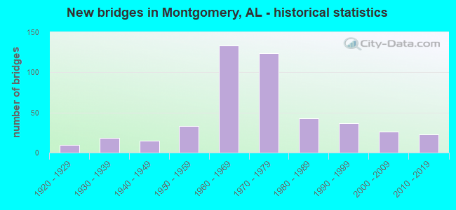
- New bridges - historical statistics
- 11910-1919
- 101920-1929
- 181930-1939
- 151940-1949
- 331950-1959
- 1331960-1969
- 1241970-1979
- 431980-1989
- 371990-1999
- 262000-2009
- 232010-2019
- 12020-2022
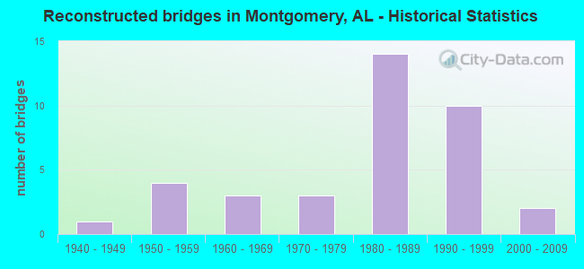
- Reconstructed bridges - Historical Statistics
- 11940-1949
- 41950-1959
- 31960-1969
- 31970-1979
- 141980-1989
- 101990-1999
- 22000-2009
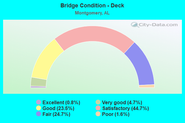
- Bridge Condition - Deck
- 0.8%Excellent
- 4.7%Very good
- 23.5%Good
- 44.7%Satisfactory
- 24.7%Fair
- 1.6%Poor
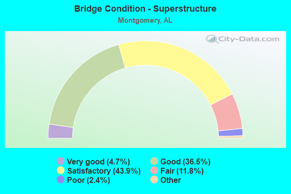
- Bridge Condition - Superstructure
- 4.7%Excellent
- 36.5%Very good
- 43.9%Good
- 11.8%Satisfactory
- 2.4%Fair
- 0.8%Poor
- 0.4%Serious
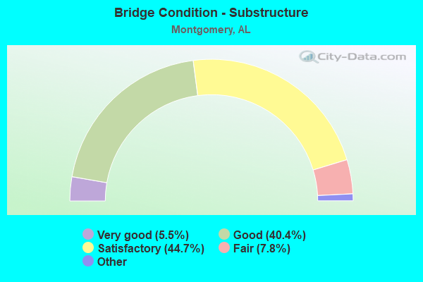
- Bridge Condition - Substructure
- 5.5%Excellent
- 40.4%Very good
- 44.7%Good
- 7.8%Satisfactory
- 1.6%Fair
- 0.8%Poor
- 0.4%Serious
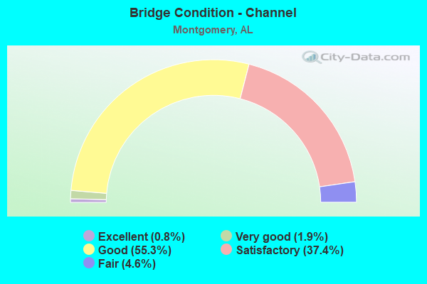
- Bridge Condition - Channel
- 0.8%Excellent
- 1.9%Very good
- 55.3%Good
- 37.4%Satisfactory
- 4.6%Fair
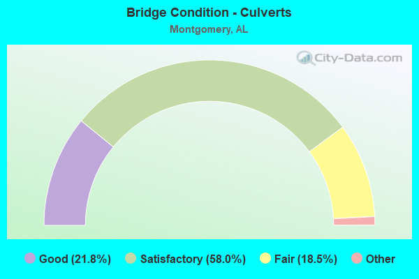
- Bridge Condition - Culverts
- 21.8%Excellent
- 58.0%Very good
- 18.5%Good
- 1.7%Satisfactory
- 18.5%Fair
Find on map >> Show street view
Structure Number: 4992, Location: 0.1 MI E OF I-65 (Lat: 32.351594, Lng: -86.319658), Route carried "on" structure: City street , Year Built: 1925, Year Reconstructed: 1955, Status: Open, Structure Length: 1.10m (3.61ft), Average Daily Traffic: 25,000 (year 1988), Truck Traffic: 2%, Average Future Daily Traffic: 35,176 (year 2038), Design Load: H 15, Features Intersected: GENETTA DITCH, Facility Carried by Structure: W FAIRVIEW AVE
Minimum Vertical Clearance: 4.37m (14.34ft), Kilometerpoint: 143.299, Lanes on structure: 4, Owner: City or Municipal Highway Agency, Approaching Roadway Width: 14.6m (47.9ft), Material/Design: Concrete continuous, Design/Construction: Culvert, Number Of Spans In Main Unit: 2, Length of Maximum Span: 4.9m (16.1ft), Curb or Sidewalk Widths: Left: 1.5m (4.9ft), Right: 1.5m (4.9ft), Curb-To-Curb Width: 14.6m (47.9ft), Out-to-Out Width: 22.9m (75.1ft)
Condition: Channel: Satisfactory, Culverts: Satisfactory, Operating Rating: 32.7 metric tons, Method Used To Determine Operating Rating: Field evaluation and documented engineering judgment, Inventory Rating: 23.6 metric tons, Method Used To Determine Inventory Rating: Field evaluation and documented engineering judgment, Structural Evaluation: Somewhat better than minimum adequacy, Deck Geometry: High priority of replacement, Waterway Adequacy: Better than present minimum criteria, Approach Roadway Alignment: Better than present minimum criteria, Length Of Structure Improvement: 1.77m (5.81ft), Designated Inspection Frequency: Every 24 months, Inspection Date: September 2020, Bridge Improvement Cost: $768,000, Roadway Improvement Cost: $77,000, Total Project Cost: $845,000 ( Estimate for 2022)
Find on map >> Show street view
Structure Number: 4993, Location: 0.45 MI S OF ALA RIVER (Lat: 32.405736, Lng: -86.406233), Route carried "on" structure: US 31, Year Built: 1926, Year Reconstructed: 1955, Status: Open, Structure Length: 0.70m (2.30ft), Average Daily Traffic: 20,900 (year 2013), Truck Traffic: 8%, Average Future Daily Traffic: 26,848 (year 2033), Design Load: H 20, Features Intersected: DRAINAGE CANAL
Minimum Vertical Clearance: 30+ m (98+ ft), Kilometerpoint: 298.414, Lanes on structure: 4, Base Highway Network: Yes, Owner: State Highway Agency, Approaching Roadway Width: 18.9m (62.0ft), Skew: 10 degrees, Material/Design: Concrete continuous, Design/Construction: Culvert, Number Of Spans In Main Unit: 2, Length of Maximum Span: 3.0m (9.8ft)
Condition: Channel: Satisfactory, Culverts: Fair, Operating Rating: 32.7 metric tons, Method Used To Determine Operating Rating: Field evaluation and documented engineering judgment, Inventory Rating: 23.6 metric tons, Method Used To Determine Inventory Rating: Field evaluation and documented engineering judgment, Structural Evaluation: Somewhat better than minimum adequacy, Waterway Adequacy: Superior to present desirable criteria, Approach Roadway Alignment: Better than present minimum criteria, Length Of Structure Improvement: 1.34m (4.40ft), Designated Inspection Frequency: Every 24 months, Inspection Date: July 2021, Bridge Improvement Cost: $1,044,000, Roadway Improvement Cost: $104,000, Total Project Cost: $1,148,000 ( Estimate for 2022)
Find on map >> Show street view
Structure Number: 5001, Location: 0.6 MI W OF I-65 (Lat: 32.351344, Lng: -86.330883), Route carried "on" structure: City street , Year Built: 1934, Year Reconstructed: 1955, Status: Open, Structure Length: 5.36m (17.59ft), Average Daily Traffic: 24,500 (year 1988), Truck Traffic: 2%, Average Future Daily Traffic: 35,000 (year 2040), Design Load: HS 20, Features Intersected: SCL RR, Facility Carried by Structure: W FAIRVIEW AVE
Minimum Vertical Clearance: 4.37m (14.34ft), Kilometerpoint: 142.599, Lanes on structure: 4, Owner: City or Municipal Highway Agency, Approaching Roadway Width: 24.4m (80.1ft), Material/Design: Concrete, Design/Construction: Tee Beam, Number Of Spans In Main Unit: 5, Length of Maximum Span: 12.2m (40.0ft), Curb or Sidewalk Widths: Left: 1.7m (5.6ft), Right: 1.7m (5.6ft), Curb-To-Curb Width: 20.7m (67.9ft), Out-to-Out Width: 24.4m (80.1ft)
Condition: Deck: Satisfactory, Superstructure: Satisfactory, Substructure: Satisfactory, Operating Rating: 44.6 metric tons, Method Used To Determine Operating Rating: Load Factor (LF), Inventory Rating: 26.8 metric tons, Method Used To Determine Inventory Rating: Load Factor (LF), Structural Evaluation: Equal to present minimum criteria, Deck Geometry: Superior to present desirable criteria, Underclear: Meets minimum limits, Approach Roadway Alignment: Equal to present minimum criteria, Length Of Structure Improvement: 6.39m (20.96ft), Designated Inspection Frequency: Every 24 months, Inspection Date: November 2020, Bridge Improvement Cost: $3,506,000, Roadway Improvement Cost: $351,000, Total Project Cost: $3,857,000 ( Estimate for 2022), Deck Structure Type: Concrete Cast-file-Place, Wearing Surface/Protective System: Wearing Surface: Bituminous
Find on map >> Show street view
Structure Number: 5088, Location: 0.6 MI S OF SO BY PASS (Lat: 32.319253, Lng: -86.349072), Route carried "on" structure: US 31, Year Built: 1955, Status: Open, Structure Length: 23.87m (78.31ft), Average Daily Traffic: 7,885 (year 2013), Truck Traffic: 9%, Average Future Daily Traffic: 10,129 (year 2033), Design Load: HS 20, Features Intersected: CATOMA CREEK
Minimum Vertical Clearance: 30+ m (98+ ft), Kilometerpoint: 286.114, Lanes on structure: 2, Base Highway Network: Yes, Owner: State Highway Agency, Approaching Roadway Width: 12.2m (40.0ft), Skew: 10 degrees, Material/Design: Concrete continuous, Design/Construction: Tee Beam, Number Of Spans In Main Unit: 21, Length of Maximum Span: 21.3m (69.9ft), Curb-To-Curb Width: 8.5m (27.9ft), Out-to-Out Width: 9.4m (30.8ft)
Condition: Deck: Poor, Superstructure: Fair, Substructure: Satisfactory, Channel: Satisfactory, Operating Rating: 38.2 metric tons, Method Used To Determine Operating Rating: Load Factor (LF), Inventory Rating: 24.7 metric tons, Method Used To Determine Inventory Rating: Load Factor (LF), Structural Evaluation: Somewhat better than minimum adequacy, Deck Geometry: High priority of corrective action, Waterway Adequacy: Better than present minimum criteria, Approach Roadway Alignment: Better than present minimum criteria, Length Of Structure Improvement: 23.87m (78.31ft), Designated Inspection Frequency: Every 24 months, Other Special Inspection Frequency: Every 12 months, Inspection Date: November 2021, Other Special Inspection Date: November 2021, Bridge Improvement Cost: $4,910,000, Roadway Improvement Cost: $491,000, Total Project Cost: $5,401,000 ( Estimate for 2022), Deck Structure Type: Concrete Cast-file-Place
Find on map >> Show street view
Structure Number: 5089, Location: 0.6 MI S OF ELMORE CO LIN (Lat: 32.410000, Lng: -86.408333), Route carried "on" structure: US 31, Year Built: 1955, Status: Open, Structure Length: 70.44m (231.10ft), Average Daily Traffic: 10,450 (year 2013), Truck Traffic: 8%, Average Future Daily Traffic: 13,424 (year 2033), Design Load: HS 20, Features Intersected: ALABAMA RIVER
Minimum Vertical Clearance: 30+ m (98+ ft), Kilometerpoint: 299.140, Lanes on structure: 2, Base Highway Network: Yes, Owner: State Highway Agency, Approaching Roadway Width: 14.6m (47.9ft), Skew: 10 degrees, Navigation Control: Yes ( Vertical Clearance: 18.3m (60.0ft), Horizontal Clearance: 48.8m (160.1ft)), Material/Design: Steel continuous, Design/Construction: Girder and Floorbeam System, Number Of Spans In Main Unit: 4, Number Of Approach Spans: 35, Length of Maximum Span: 67.1m (220.1ft), Curb-To-Curb Width: 8.5m (27.9ft), Out-to-Out Width: 9.8m (32.2ft)
Condition: Deck: Fair, Superstructure: Fair, Substructure: Fair, Channel: Good, Operating Rating: 47.6 metric tons, Method Used To Determine Operating Rating: Load Factor (LF), Inventory Rating: 28.5 metric tons, Method Used To Determine Inventory Rating: Load Factor (LF), Structural Evaluation: Somewhat better than minimum adequacy, Deck Geometry: High priority of corrective action, Waterway Adequacy: Superior to present desirable criteria, Approach Roadway Alignment: Better than present minimum criteria, Length Of Structure Improvement: 70.44m (231.10ft), Designated Inspection Frequency: Every 24 months, Critical Feature Inspection Frequency: Every 24 months, Underwater Inspection Frequency: Every 24 months, Inspection Date: September 2020, Critical Feature Inspection Date: September 2020, Underwater Inspection Date: June 2020, Bridge Improvement Cost: $15,456,000, Roadway Improvement Cost: $1,546,000, Total Project Cost: $17,002,000 ( Estimate for 2022), Deck Structure Type: Concrete Cast-file-Place
Find on map >> Show street view
Structure Number: 5125, Location: 0.4 MI W OF I65 (Lat: 32.328333, Lng: -86.341667), Route carried "on" structure: State highway 21, Year Built: 1955, Status: Open, Structure Length: 1.58m (5.18ft), Average Daily Traffic: 20,760 (year 2013), Truck Traffic: 7%, Average Future Daily Traffic: 25,889 (year 2033), Design Load: HS 20, Features Intersected: GENETTA DITCH
Minimum Vertical Clearance: 7.56m (24.80ft), Kilometerpoint: 224.508, Lanes on structure: 4, Base Highway Network: Yes, Owner: State Highway Agency, Approaching Roadway Width: 32.6m (107.0ft), Skew: 3 degrees, Material/Design: Concrete continuous, Design/Construction: Culvert, Number Of Spans In Main Unit: 3, Length of Maximum Span: 4.3m (14.1ft)
Condition: Channel: Fair, Culverts: Fair, Operating Rating: 40.3 metric tons, Method Used To Determine Operating Rating: Load Factor (LF), Inventory Rating: 24.1 metric tons, Method Used To Determine Inventory Rating: Load Factor (LF), Structural Evaluation: Somewhat better than minimum adequacy, Waterway Adequacy: Superior to present desirable criteria, Approach Roadway Alignment: Better than present minimum criteria, Length Of Structure Improvement: 2.26m (7.41ft), Designated Inspection Frequency: Every 24 months, Inspection Date: Febuary 2022, Bridge Improvement Cost: $2,142,000, Roadway Improvement Cost: $214,000, Total Project Cost: $2,356,000 ( Estimate for 2020)
Find on map >> Show street view
Structure Number: 5126, Location: 1.1 MI E OF I65 (Lat: 32.326461, Lng: -86.318825), Route carried "on" structure: US 82, Year Built: 1955, Status: Open, Structure Length: 4.39m (14.40ft), Average Daily Traffic: 17,650 (year 2013), Truck Traffic: 8%, Average Future Daily Traffic: 22,852 (year 2033), Design Load: HS 20, Features Intersected: SCL RR
Minimum Vertical Clearance: 30+ m (98+ ft), Kilometerpoint: 248.058, Lanes on structure: 2, Base Highway Network: Yes, Owner: State Highway Agency, Approaching Roadway Width: 10.4m (34.1ft), Skew: 14 degrees, Material/Design: Concrete, Design/Construction: Tee Beam, Number Of Spans In Main Unit: 5, Length of Maximum Span: 12.2m (40.0ft), Curb or Sidewalk Widths: Left: 1.4m (4.6ft), Right: 0.0m, Curb-To-Curb Width: 7.5m (24.6ft), Out-to-Out Width: 10.2m (33.5ft)
Condition: Deck: Fair, Superstructure: Fair, Substructure: Satisfactory, Operating Rating: 32.2 metric tons, Method Used To Determine Operating Rating: Load Factor (LF), Inventory Rating: 19.3 metric tons, Method Used To Determine Inventory Rating: Load Factor (LF), Structural Evaluation: Meets minimum limits, Deck Geometry: High priority of replacement, Underclear: Meets minimum limits, Approach Roadway Alignment: Better than present minimum criteria, Length Of Structure Improvement: 5.37m (17.62ft), Designated Inspection Frequency: Every 24 months, Inspection Date: September 2021, Bridge Improvement Cost: $1,216,000, Roadway Improvement Cost: $122,000, Total Project Cost: $1,338,000 ( Estimate for 2022), Deck Structure Type: Concrete Cast-file-Place
Find on map >> Show street view
Structure Number: 5127, Location: 1.1 MI.E.OF I65 (Lat: 32.326581, Lng: -86.318850), Route carried "on" structure: US 82, Year Built: 1955, Status: Open, Structure Length: 4.39m (14.40ft), Average Daily Traffic: 17,650 (year 2013), Truck Traffic: 8%, Average Future Daily Traffic: 22,852 (year 2033), Design Load: HS 20, Features Intersected: SCL RR
Minimum Vertical Clearance: 30+ m (98+ ft), Kilometerpoint: 248.058, Lanes on structure: 2, Base Highway Network: Yes, Owner: State Highway Agency, Approaching Roadway Width: 10.4m (34.1ft), Skew: 14 degrees, Material/Design: Concrete, Design/Construction: Tee Beam, Number Of Spans In Main Unit: 5, Length of Maximum Span: 12.2m (40.0ft), Curb or Sidewalk Widths: Left: 1.4m (4.6ft), Right: 0.0m, Curb-To-Curb Width: 8.5m (27.9ft), Out-to-Out Width: 10.2m (33.5ft)
Condition: Deck: Fair, Superstructure: Fair, Substructure: Satisfactory, Operating Rating: 32.2 metric tons, Method Used To Determine Operating Rating: Load Factor (LF), Inventory Rating: 19.3 metric tons, Method Used To Determine Inventory Rating: Load Factor (LF), Structural Evaluation: Meets minimum limits, Deck Geometry: High priority of corrective action, Underclear: Meets minimum limits, Approach Roadway Alignment: Better than present minimum criteria, Length Of Structure Improvement: 5.37m (17.62ft), Designated Inspection Frequency: Every 24 months, Inspection Date: September 2021, Bridge Improvement Cost: $1,216,000, Roadway Improvement Cost: $122,000, Total Project Cost: $1,338,000 ( Estimate for 2022), Deck Structure Type: Concrete Cast-file-Place
Find on map >> Show street view
Structure Number: 5128, Location: 0.5 MI E OF NORMAN BRDG R (Lat: 32.326667, Lng: -86.291667), Route carried "on" structure: US 82, Year Built: 1955, Status: Open, Structure Length: 0.79m (2.59ft), Average Daily Traffic: 32,740 (year 2013), Truck Traffic: 6%, Average Future Daily Traffic: 42,390 (year 2033), Design Load: HS 20, Features Intersected: BRANCH
Minimum Vertical Clearance: 30+ m (98+ ft), Kilometerpoint: 250.644, Lanes on structure: 8, Base Highway Network: Yes, Owner: State Highway Agency, Approaching Roadway Width: 32.8m (107.6ft), Skew: 1 degrees, Material/Design: Concrete continuous, Design/Construction: Culvert, Number Of Spans In Main Unit: 2, Length of Maximum Span: 3.7m (12.1ft)
Condition: Channel: Good, Culverts: Fair, Operating Rating: 58.6 metric tons, Method Used To Determine Operating Rating: Load Factor (LF), Inventory Rating: 35.2 metric tons, Method Used To Determine Inventory Rating: Load Factor (LF), Structural Evaluation: Somewhat better than minimum adequacy, Waterway Adequacy: Superior to present desirable criteria, Approach Roadway Alignment: Better than present minimum criteria, Length Of Structure Improvement: 1.44m (4.72ft), Designated Inspection Frequency: Every 24 months, Inspection Date: September 2021, Bridge Improvement Cost: $984,000, Roadway Improvement Cost: $98,000, Total Project Cost: $1,082,000 ( Estimate for 2022)
Find on map >> Show street view
Structure Number: 5129, Location: 0.5 MI E NARROWLANE RD (Lat: 32.326667, Lng: -86.273333), Route carried "on" structure: US 82, Year Built: 1955, Status: Open, Structure Length: 0.70m (2.30ft), Average Daily Traffic: 40,960 (year 2013), Truck Traffic: 6%, Average Future Daily Traffic: 53,033 (year 2033), Design Load: HS 20, Features Intersected: BRANCH
Minimum Vertical Clearance: 30+ m (98+ ft), Kilometerpoint: 252.442, Lanes on structure: 4, Base Highway Network: Yes, Owner: State Highway Agency, Approaching Roadway Width: 22.6m (74.1ft), Skew: 10 degrees, Material/Design: Concrete continuous, Design/Construction: Culvert, Number Of Spans In Main Unit: 2, Length of Maximum Span: 3.0m (9.8ft)
Condition: Channel: Fair, Culverts: Fair, Operating Rating: 88.9 metric tons, Method Used To Determine Operating Rating: Load Factor (LF), Inventory Rating: 88.9 metric tons, Method Used To Determine Inventory Rating: Load Factor (LF), Structural Evaluation: Somewhat better than minimum adequacy, Waterway Adequacy: Superior to present desirable criteria, Approach Roadway Alignment: Better than present minimum criteria, Length Of Structure Improvement: 1.34m (4.40ft), Designated Inspection Frequency: Every 24 months, Inspection Date: September 2021, Bridge Improvement Cost: $959,000, Roadway Improvement Cost: $96,000, Total Project Cost: $1,055,000 ( Estimate for 2022)
Find on map >> Show street view
Structure Number: 513, Location: 0.6 MI E OF WOODLEY RD (Lat: 32.316842, Lng: -86.233508), Route carried "on" structure: US 82, Year Built: 1955, Status: Open, Structure Length: 1.16m (3.81ft), Average Daily Traffic: 42,870 (year 2013), Truck Traffic: 6%, Average Future Daily Traffic: 55,506 (year 2033), Design Load: HS 20, Features Intersected: BRANCH
Minimum Vertical Clearance: 7.56m (24.80ft), Kilometerpoint: 254.051, Lanes on structure: 6, Base Highway Network: Yes, Owner: State Highway Agency, Approaching Roadway Width: 29.3m (96.1ft), Skew: 10 degrees, Material/Design: Concrete continuous, Design/Construction: Culvert, Number Of Spans In Main Unit: 3, Length of Maximum Span: 3.7m (12.1ft)
Condition: Channel: Good, Culverts: Fair, Operating Rating: 54.0 metric tons, Method Used To Determine Operating Rating: Load Factor (LF), Inventory Rating: 32.4 metric tons, Method Used To Determine Inventory Rating: Load Factor (LF), Structural Evaluation: Somewhat better than minimum adequacy, Waterway Adequacy: Superior to present desirable criteria, Approach Roadway Alignment: Better than present minimum criteria, Length Of Structure Improvement: 1.84m (6.04ft), Designated Inspection Frequency: Every 24 months, Inspection Date: October 2021, Bridge Improvement Cost: $2,100,000, Roadway Improvement Cost: $210,000, Total Project Cost: $2,310,000 ( Estimate for 2022)
Find on map >> Show street view
Structure Number: 5131, Location: JCT US 82 * US 231 (Lat: 32.316842, Lng: -86.250067), Route carried "on" structure: US 82, Year Built: 1955, Status: Open, Structure Length: 1.10m (3.61ft), Average Daily Traffic: 42,870 (year 2013), Truck Traffic: 6%, Average Future Daily Traffic: 55,506 (year 2033), Design Load: HS 20, Features Intersected: BRANCH
Minimum Vertical Clearance: 7.56m (24.80ft), Kilometerpoint: 254.984, Lanes on structure: 6, Base Highway Network: Yes, Owner: State Highway Agency, Approaching Roadway Width: 41.8m (137.1ft), Skew: 15 degrees, Material/Design: Concrete continuous, Design/Construction: Culvert, Number Of Spans In Main Unit: 2, Length of Maximum Span: 3.0m (9.8ft)
Condition: Channel: Satisfactory, Culverts: Fair, Operating Rating: 88.9 metric tons, Method Used To Determine Operating Rating: Load Factor (LF), Inventory Rating: 88.9 metric tons, Method Used To Determine Inventory Rating: Load Factor (LF), Structural Evaluation: Somewhat better than minimum adequacy, Waterway Adequacy: Superior to present desirable criteria, Approach Roadway Alignment: Better than present minimum criteria, Length Of Structure Improvement: 1.77m (5.81ft), Designated Inspection Frequency: Every 24 months, Inspection Date: October 2021, Bridge Improvement Cost: $3,658,000, Roadway Improvement Cost: $366,000, Total Project Cost: $4,024,000 ( Estimate for 2022)
Find on map >> Show street view
Structure Number: 5158, Location: JCT OF AL 14 * US 231 (Lat: 32.368333, Lng: -86.191667), Route carried "on" structure: US 231, Year Built: 1955, Status: Open, Structure Length: 0.98m (3.22ft), Average Daily Traffic: 20,910 (year 2013), Truck Traffic: 6%, Average Future Daily Traffic: 28,498 (year 2033), Design Load: HS 20, Features Intersected: BRANCH
Minimum Vertical Clearance: 30+ m (98+ ft), Kilometerpoint: 197.624, Lanes on structure: 8, Base Highway Network: Yes, Owner: State Highway Agency, Approaching Roadway Width: 26.0m (85.3ft), Skew: 13 degrees, Material/Design: Concrete continuous, Design/Construction: Culvert, Number Of Spans In Main Unit: 3, Length of Maximum Span: 3.0m (9.8ft)
Condition: Channel: Satisfactory, Culverts: Satisfactory, Operating Rating: 88.9 metric tons, Method Used To Determine Operating Rating: Load Factor (LF), Inventory Rating: 69.6 metric tons, Method Used To Determine Inventory Rating: Load Factor (LF), Structural Evaluation: Equal to present minimum criteria, Waterway Adequacy: Superior to present desirable criteria, Approach Roadway Alignment: Better than present minimum criteria, Length Of Structure Improvement: 1.65m (5.41ft), Designated Inspection Frequency: Every 24 months, Inspection Date: March 2020, Bridge Improvement Cost: $3,810,000, Roadway Improvement Cost: $381,000, Total Project Cost: $4,191,000 ( Estimate for 2022)
Find on map >> Show street view
Structure Number: 5161, Location: 0.5 MI.N. BYPASS (Lat: 32.427636, Lng: -86.223261), Route carried "on" structure: US 231, Year Built: 1955, Status: Open, Structure Length: 0.98m (3.22ft), Average Daily Traffic: 32,030 (year 2013), Truck Traffic: 4%, Average Future Daily Traffic: 43,653 (year 2033), Design Load: H 15, Features Intersected: STREAM
Minimum Vertical Clearance: 7.56m (24.80ft), Kilometerpoint: 181.040, Lanes on structure: 5, Base Highway Network: Yes, Owner: State Highway Agency, Approaching Roadway Width: 24.4m (80.1ft), Skew: 10 degrees, Material/Design: Concrete continuous, Design/Construction: Culvert, Number Of Spans In Main Unit: 3, Length of Maximum Span: 3.0m (9.8ft)
Condition: Channel: Satisfactory, Culverts: Fair, Operating Rating: 88.9 metric tons, Method Used To Determine Operating Rating: Load Factor (LF), Inventory Rating: 68.5 metric tons, Method Used To Determine Inventory Rating: Load Factor (LF), Structural Evaluation: Somewhat better than minimum adequacy, Waterway Adequacy: Superior to present desirable criteria, Approach Roadway Alignment: Better than present minimum criteria, Length Of Structure Improvement: 1.65m (5.41ft), Designated Inspection Frequency: Every 24 months, Underwater Inspection Frequency: Every 24 months, Inspection Date: June 2020, Underwater Inspection Date: June 2020, Bridge Improvement Cost: $1,022,000, Roadway Improvement Cost: $102,000, Total Project Cost: $1,124,000 ( Estimate for 2022)
Find on map >> Show street view
Structure Number: 5162, Location: MONTGOMERY ELMORE CO LINE (Lat: 32.455000, Lng: -86.203333), Route carried "on" structure: US 231, Year Built: 1955, Status: Open, Structure Length: 32.61m (106.99ft), Average Daily Traffic: 16,115 (year 2013), Truck Traffic: 4%, Average Future Daily Traffic: 21,962 (year 2033), Design Load: H 20, Features Intersected: TALLAPOOSA RIVER
Minimum Vertical Clearance: 30+ m (98+ ft), Kilometerpoint: 184.698, Lanes on structure: 2, Base Highway Network: Yes, Owner: State Highway Agency, Approaching Roadway Width: 14.0m (45.9ft), Skew: 10 degrees, Material/Design: Steel continuous, Design/Construction: Girder and Floorbeam System, Number Of Spans In Main Unit: 4, Number Of Approach Spans: 13, Length of Maximum Span: 54.9m (180.1ft), Curb-To-Curb Width: 8.5m (27.9ft), Out-to-Out Width: 9.4m (30.8ft)
Condition: Deck: Fair, Superstructure: Satisfactory, Substructure: Good, Channel: Satisfactory, Operating Rating: 37.2 metric tons, Method Used To Determine Operating Rating: Load Factor (LF), Inventory Rating: 22.3 metric tons, Method Used To Determine Inventory Rating: Load Factor (LF), Structural Evaluation: Somewhat better than minimum adequacy, Deck Geometry: High priority of corrective action, Waterway Adequacy: Superior to present desirable criteria, Approach Roadway Alignment: Better than present minimum criteria, Length Of Structure Improvement: 32.61m (106.99ft), Designated Inspection Frequency: Every 24 months, Critical Feature Inspection Frequency: Every 24 months, Underwater Inspection Frequency: Every 24 months, Inspection Date: September 2020, Critical Feature Inspection Date: September 2020, Underwater Inspection Date: August 2021, Bridge Improvement Cost: $6,708,000, Roadway Improvement Cost: $671,000, Total Project Cost: $7,379,000 ( Estimate for 2022), Deck Structure Type: Concrete Cast-file-Place
Find on map >> Show street view
Structure Number: 5831, Location: 0.25 MI E OF CNTRYSIDE LN (Lat: 32.405350, Lng: -86.181958), Route carried "on" structure: City street 8, Year Built: 1957, Status: Open, Structure Length: 2.13m (6.99ft), Average Daily Traffic: 1,200 (year 1993), Truck Traffic: 1%, Average Future Daily Traffic: 1,515 (year 2038), Design Load: H 15, Features Intersected: STREAM, Facility Carried by Structure: WARES FERRY RD
Minimum Vertical Clearance: 7.56m (24.80ft), Kilometerpoint: 4.699, Lanes on structure: 2, Owner: City or Municipal Highway Agency, Approaching Roadway Width: 7.9m (25.9ft), Skew: 1 degrees, Material/Design: Concrete, Design/Construction: Slab, Number Of Spans In Main Unit: 3, Length of Maximum Span: 6.1m (20.0ft), Curb-To-Curb Width: 6.7m (22.0ft), Out-to-Out Width: 7.3m (24.0ft)
Condition: Deck: Satisfactory, Superstructure: Satisfactory, Substructure: Satisfactory, Channel: Satisfactory, Operating Rating: 32.7 metric tons, Method Used To Determine Operating Rating: Field evaluation and documented engineering judgment, Inventory Rating: 23.6 metric tons, Method Used To Determine Inventory Rating: Field evaluation and documented engineering judgment, Structural Evaluation: Equal to present minimum criteria, Deck Geometry: High priority of corrective action, Waterway Adequacy: Equal to present minimum criteria, Approach Roadway Alignment: Equal to present minimum criteria, Length Of Structure Improvement: 2.91m (9.55ft), Designated Inspection Frequency: Every 24 months, Underwater Inspection Frequency: Every 48 months, Inspection Date: Febuary 2022, Underwater Inspection Date: Febuary 2021, Bridge Improvement Cost: $480,000, Roadway Improvement Cost: $48,000, Total Project Cost: $528,000 ( Estimate for 2022), Deck Structure Type: Concrete Cast-file-Place, Wearing Surface/Protective System: Wearing Surface: Bituminous
Find on map >> Show street view
Structure Number: 5833, Location: 1.4 MI E OF EASTERN BLVD (Lat: 32.382492, Lng: -86.186675), Route carried "on" structure: City street 80, Year Built: 1957, Status: Open, Structure Length: 2.41m (7.91ft), Average Daily Traffic: 18,520 (year 2009), Truck Traffic: 6%, Average Future Daily Traffic: 40,580 (year 2038), Design Load: HS 20, Features Intersected: OLIVER CREEK, Facility Carried by Structure: ATLANTA HWY
Minimum Vertical Clearance: 7.56m (24.80ft), Kilometerpoint: 2.253, Lanes on structure: 3, Owner: City or Municipal Highway Agency, Approaching Roadway Width: 12.2m (40.0ft), Skew: 10 degrees, Material/Design: Concrete continuous, Design/Construction: Culvert, Number Of Spans In Main Unit: 5, Length of Maximum Span: 4.6m (15.1ft)
Condition: Channel: Good, Culverts: Satisfactory, Operating Rating: 43.3 metric tons, Method Used To Determine Operating Rating: Load Factor (LF), Inventory Rating: 25.9 metric tons, Method Used To Determine Inventory Rating: Load Factor (LF), Structural Evaluation: Equal to present minimum criteria, Waterway Adequacy: Better than present minimum criteria, Approach Roadway Alignment: Better than present minimum criteria, Length Of Structure Improvement: 3.27m (10.73ft), Designated Inspection Frequency: Every 24 months, Inspection Date: Febuary 2022, Bridge Improvement Cost: $925,000, Roadway Improvement Cost: $93,000, Total Project Cost: $1,018,000 ( Estimate for 2022)
Find on map >> Show street view
Structure Number: 6013, Location: 0.15 MI N OF AFB ENTRANCE (Lat: 32.372689, Lng: -86.350128), Route carried "on" structure: City street , Year Built: 1957, Status: Open, Structure Length: 11.09m (36.38ft), Average Daily Traffic: 10,000 (year 1993), Truck Traffic: 1%, Average Future Daily Traffic: 15,150 (year 2040), Design Load: H 20, Features Intersected: BELL ST, Facility Carried by Structure: AIR BASE BLVD
Minimum Vertical Clearance: 5.26m (17.26ft), Kilometerpoint: 1.920, Lanes on structure: 4, Lanes under structure: 2, Owner: City or Municipal Highway Agency, Approaching Roadway Width: 14.6m (47.9ft), Material/Design: Steel, Design/Construction: Stringer/Multi-beam, Number Of Spans In Main Unit: 5, Length of Maximum Span: 21.9m (71.9ft), Curb-To-Curb Width: 17.1m (56.1ft), Out-to-Out Width: 18.3m (60.0ft)
Condition: Deck: Satisfactory, Superstructure: Satisfactory, Substructure: Satisfactory, Operating Rating: 82.3 metric tons, Method Used To Determine Operating Rating: Load Factor (LF), Inventory Rating: 49.3 metric tons, Method Used To Determine Inventory Rating: Load Factor (LF), Structural Evaluation: Equal to present minimum criteria, Deck Geometry: High priority of corrective action, Approach Roadway Alignment: Better than present minimum criteria, Length Of Structure Improvement: 11.98m (39.30ft), Designated Inspection Frequency: Every 24 months, Inspection Date: November 2020, Bridge Improvement Cost: $4,927,000, Roadway Improvement Cost: $493,000, Total Project Cost: $5,420,000 ( Estimate for 2022), Deck Structure Type: Concrete Cast-file-Place
Find on map >> Show street view
Structure Number: 6155, Location: 23.6 MI N PIKE CO LINE (Lat: 32.277150, Lng: -86.218911), Route carried "on" structure: County highway 3, Year Built: 1958, Status: Posted for load, Structure Length: 5.18m (16.99ft), Average Daily Traffic: 900 (year 1988), Truck Traffic: 1%, Average Future Daily Traffic: 1,500 (year 2041), Design Load: H 15, Features Intersected: CATOMA CREEK RELIEF, Facility Carried by Structure: WOODLEY ROAD
Minimum Vertical Clearance: 30+ m (98+ ft), Kilometerpoint: 0.010, Lanes on structure: 2, Owner: County Highway Agency, Approaching Roadway Width: 7.6m (24.9ft), Material/Design: Concrete, Design/Construction: Tee Beam, Number Of Spans In Main Unit: 5, Length of Maximum Span: 10.4m (34.1ft), Curb-To-Curb Width: 6.7m (22.0ft), Out-to-Out Width: 7.6m (24.9ft)
Condition: Deck: Good, Superstructure: Good, Substructure: Good, Channel: Good, Operating Rating: 37.3 metric tons, Method Used To Determine Operating Rating: Allowable Stress (AS), Inventory Rating: 21.7 metric tons, Method Used To Determine Inventory Rating: Allowable Stress (AS), Structural Evaluation: Somewhat better than minimum adequacy, Deck Geometry: Meets minimum limits, Waterway Adequacy: Better than present minimum criteria, Approach Roadway Alignment: Better than present minimum criteria, Bridge Posting: Required (Relationship of Operating Rating to Maximum Legal Load: 10.0 - 19.9% below), Length Of Structure Improvement: 6.20m (20.34ft), Designated Inspection Frequency: Every 24 months, Other Special Inspection Frequency: Every 12 months, Inspection Date: November 2020, Other Special Inspection Date: November 2021, Bridge Improvement Cost: $1,021,000, Roadway Improvement Cost: $102,000, Total Project Cost: $1,123,000 ( Estimate for 2022), Deck Structure Type: Concrete Cast-file-Place, Wearing Surface/Protective System: Wearing Surface: Bituminous
Find on map >> Show street view
Structure Number: 6156, Location: 23.7 MI N PIKE CO LINE (Lat: 32.278092, Lng: -86.219172), Route carried "on" structure: County highway 3, Year Built: 1958, Status: Posted for load, Structure Length: 5.67m (18.60ft), Average Daily Traffic: 900 (year 1988), Truck Traffic: 1%, Average Future Daily Traffic: 1,500 (year 2041), Design Load: H 15, Features Intersected: CATOMA CREEK, Facility Carried by Structure: WOODLEY ROAD
Minimum Vertical Clearance: 30+ m (98+ ft), Kilometerpoint: 0.010, Lanes on structure: 2, Owner: County Highway Agency, Approaching Roadway Width: 7.6m (24.9ft), Material/Design: Concrete, Design/Construction: Tee Beam, Number Of Spans In Main Unit: 5, Length of Maximum Span: 15.2m (49.9ft), Curb-To-Curb Width: 6.7m (22.0ft), Out-to-Out Width: 7.6m (24.9ft)
Condition: Deck: Good, Superstructure: Good, Substructure: Good, Channel: Satisfactory, Operating Rating: 37.7 metric tons, Method Used To Determine Operating Rating: Allowable Stress (AS), Inventory Rating: 22.1 metric tons, Method Used To Determine Inventory Rating: Allowable Stress (AS), Structural Evaluation: Somewhat better than minimum adequacy, Deck Geometry: Meets minimum limits, Waterway Adequacy: Better than present minimum criteria, Approach Roadway Alignment: Equal to present desirable criteria, Bridge Posting: Required (Relationship of Operating Rating to Maximum Legal Load: 10.0 - 19.9% below), Length Of Structure Improvement: 6.70m (21.98ft), Designated Inspection Frequency: Every 24 months, Other Special Inspection Frequency: Every 12 months, Inspection Date: November 2020, Other Special Inspection Date: November 2021, Bridge Improvement Cost: $1,103,000, Roadway Improvement Cost: $110,000, Total Project Cost: $1,213,000 ( Estimate for 2022), Deck Structure Type: Concrete Cast-file-Place, Wearing Surface/Protective System: Wearing Surface: Bituminous
Find on map >> Show street view
Structure Number: 6157, Location: 24.0 MI N PIKE CO LINE (Lat: 32.282275, Lng: -86.221119), Route carried "on" structure: County highway 3, Year Built: 1958, Status: Posted for load, Structure Length: 7.25m (23.79ft), Average Daily Traffic: 900 (year 1988), Truck Traffic: 1%, Average Future Daily Traffic: 3,500 (year 2041), Design Load: H 15, Features Intersected: CATOMA CREEK RELIEF, Facility Carried by Structure: WOODLEY ROAD
Minimum Vertical Clearance: 30+ m (98+ ft), Kilometerpoint: 0.010, Lanes on structure: 2, Owner: County Highway Agency, Approaching Roadway Width: 7.6m (24.9ft), Material/Design: Concrete, Design/Construction: Tee Beam, Number Of Spans In Main Unit: 7, Length of Maximum Span: 10.4m (34.1ft), Curb-To-Curb Width: 6.7m (22.0ft), Out-to-Out Width: 7.6m (24.9ft)
Condition: Deck: Good, Superstructure: Good, Substructure: Good, Channel: Good, Operating Rating: 37.7 metric tons, Method Used To Determine Operating Rating: Allowable Stress (AS), Inventory Rating: 22.1 metric tons, Method Used To Determine Inventory Rating: Allowable Stress (AS), Structural Evaluation: Somewhat better than minimum adequacy, Deck Geometry: Meets minimum limits, Waterway Adequacy: Better than present minimum criteria, Approach Roadway Alignment: Equal to present desirable criteria, Bridge Posting: Required (Relationship of Operating Rating to Maximum Legal Load: 10.0 - 19.9% below), Length Of Structure Improvement: 8.28m (27.17ft), Designated Inspection Frequency: Every 24 months, Other Special Inspection Frequency: Every 12 months, Inspection Date: November 2020, Other Special Inspection Date: November 2021, Bridge Improvement Cost: $1,362,000, Roadway Improvement Cost: $136,000, Total Project Cost: $1,498,000 ( Estimate for 2022), Deck Structure Type: Concrete Cast-file-Place, Wearing Surface/Protective System: Wearing Surface: Bituminous
Find on map >> Show street view
Structure Number: 6255, Location: 1/2 MI WEST OF CO RD 26 (Lat: 32.240092, Lng: -86.423144), Route carried "on" structure: County highway 32, Year Built: 1958, Status: Open, Structure Length: 0.76m (2.49ft), Average Daily Traffic: 410 (year 2003), Truck Traffic: 5%, Average Future Daily Traffic: 480 (year 2028), Design Load: H 15, Features Intersected: CREEK
Minimum Vertical Clearance: 30+ m (98+ ft), Kilometerpoint: 0.010, Lanes on structure: 2, Owner: County Highway Agency, Approaching Roadway Width: 7.3m (24.0ft), Material/Design: Concrete, Design/Construction: Culvert, Number Of Spans In Main Unit: 2, Length of Maximum Span: 3.0m (9.8ft)
Condition: Channel: Satisfactory, Culverts: Good, Operating Rating: 88.9 metric tons, Method Used To Determine Operating Rating: Load Factor (LF), Inventory Rating: 76.8 metric tons, Method Used To Determine Inventory Rating: Load Factor (LF), Structural Evaluation: Better than present minimum criteria, Waterway Adequacy: Somewhat better than minimum adequacy, Approach Roadway Alignment: Equal to present minimum criteria, Length Of Structure Improvement: 1.41m (4.63ft), Designated Inspection Frequency: Every 24 months, Inspection Date: January 2021, Bridge Improvement Cost: $276,000, Roadway Improvement Cost: $28,000, Total Project Cost: $304,000 ( Estimate for 2022)
Find on map >> Show street view
Structure Number: 6453, Location: 3.8 MI N AUTAUGA CO LINE (Lat: 32.754933, Lng: -86.555317), Route carried "on" structure: Interstate 65, Year Built: 1959, Status: Open, Structure Length: 2.23m (7.32ft), Average Daily Traffic: 34,930 (year 2017), Truck Traffic: 23%, Average Future Daily Traffic: 52,395 (year 2041), Design Load: H 20, Features Intersected: CHESTNUT CREEK
Minimum Vertical Clearance: 30+ m (98+ ft), Kilometerpoint: 324.735, Lanes on structure: 4, Base Highway Network: Yes, Owner: State Highway Agency, Approaching Roadway Width: 23.8m (78.1ft), Skew: 20 degrees, Material/Design: Concrete, Design/Construction: Culvert, Number Of Spans In Main Unit: 5, Length of Maximum Span: 4.3m (14.1ft)
Condition: Channel: Satisfactory, Culverts: Satisfactory, Operating Rating: 88.9 metric tons, Method Used To Determine Operating Rating: Load Factor (LF), Inventory Rating: 54.4 metric tons, Method Used To Determine Inventory Rating: Load Factor (LF), Structural Evaluation: Equal to present minimum criteria, Waterway Adequacy: Better than present minimum criteria, Approach Roadway Alignment: Equal to present desirable criteria, Length Of Structure Improvement: 3.03m (9.94ft), Designated Inspection Frequency: Every 24 months, Inspection Date: June 2021, Bridge Improvement Cost: $2,365,000, Roadway Improvement Cost: $237,000, Total Project Cost: $2,602,000 ( Estimate for 2022)
Find on map >> Show street view
Structure Number: 6461, Location: EXIT 83 (Lat: 31.330097, Lng: -87.126317), Route carried "on" structure: County highway 6, Year Built: 1959, Status: Open, Structure Length: 7.53m (24.70ft), Average Daily Traffic: 1,325 (year 2019), Truck Traffic: 8%, Average Future Daily Traffic: 1,988 (year 2039), Design Load: HS 20, Features Intersected: I-65
Minimum Vertical Clearance: 30+ m (98+ ft), Kilometerpoint: 0.000, Lanes on structure: 2, Lanes under structure: 4, Owner: State Highway Agency, Approaching Roadway Width: 7.6m (24.9ft), Material/Design: Concrete continuous, Design/Construction: Tee Beam, Number Of Spans In Main Unit: 4, Length of Maximum Span: 20.7m (67.9ft), Curb-To-Curb Width: 7.3m (24.0ft), Out-to-Out Width: 8.9m (29.2ft)
Condition: Deck: Fair, Superstructure: Fair, Substructure: Satisfactory, Operating Rating: 42.1 metric tons, Method Used To Determine Operating Rating: Load Factor (LF), Inventory Rating: 25.2 metric tons, Method Used To Determine Inventory Rating: Load Factor (LF), Structural Evaluation: Somewhat better than minimum adequacy, Deck Geometry: Meets minimum limits, Underclear: Somewhat better than minimum adequacy, Approach Roadway Alignment: Better than present minimum criteria, Length Of Structure Improvement: 8.55m (28.05ft), Designated Inspection Frequency: Every 24 months, Inspection Date: Febuary 2021, Bridge Improvement Cost: $1,700,000, Roadway Improvement Cost: $170,000, Total Project Cost: $1,870,000 ( Estimate for 2022), Deck Structure Type: Concrete Cast-file-Place
Find on map >> Show street view
Structure Number: 6462, Location: 7.8 MI N SR 41 (Lat: 31.343311, Lng: -87.101042), Route carried "on" structure: County highway , Year Built: 1959, Status: Open, Structure Length: 8.63m (28.31ft), Average Daily Traffic: 729 (year 2019), Truck Traffic: 26%, Average Future Daily Traffic: 1,093 (year 2039), Design Load: H 20, Features Intersected: I-65, Facility Carried by Structure: JOE REEVES RD.
Minimum Vertical Clearance: 30+ m (98+ ft), Kilometerpoint: 0.000, Lanes on structure: 2, Lanes under structure: 4, Owner: State Highway Agency, Approaching Roadway Width: 6.8m (22.3ft), Skew: 3 degrees, Material/Design: Concrete continuous, Design/Construction: Tee Beam, Number Of Spans In Main Unit: 4, Length of Maximum Span: 24.4m (80.1ft), Curb-To-Curb Width: 7.3m (24.0ft), Out-to-Out Width: 8.9m (29.2ft)
Condition: Deck: Fair, Superstructure: Fair, Substructure: Satisfactory, Operating Rating: 46.7 metric tons, Method Used To Determine Operating Rating: Load Factor (LF), Inventory Rating: 27.9 metric tons, Method Used To Determine Inventory Rating: Load Factor (LF), Structural Evaluation: Somewhat better than minimum adequacy, Deck Geometry: Meets minimum limits, Underclear: Somewhat better than minimum adequacy, Approach Roadway Alignment: Equal to present desirable criteria, Length Of Structure Improvement: 9.61m (31.53ft), Designated Inspection Frequency: Every 24 months, Inspection Date: January 2021, Bridge Improvement Cost: $1,911,000, Roadway Improvement Cost: $191,000, Total Project Cost: $2,102,000 ( Estimate for 2022), Deck Structure Type: Concrete Cast-file-Place
Find on map >> Show street view
Structure Number: 6463, Location: 8 MI N JCT SR 41 (Lat: 31.345506, Lng: -87.095097), Route carried "on" structure: Interstate 65, Year Built: 1959, Status: Open, Structure Length: 1.98m (6.50ft), Average Daily Traffic: 26,152 (year 2019), Truck Traffic: 28%, Average Future Daily Traffic: 39,228 (year 2039), Design Load: HS 20, Features Intersected: PANTHER CREEK
Minimum Vertical Clearance: 30+ m (98+ ft), Kilometerpoint: 137.586, Lanes on structure: 4, Base Highway Network: Yes, Owner: State Highway Agency, Approaching Roadway Width: 23.5m (77.1ft), Skew: 10 degrees, Material/Design: Concrete, Design/Construction: Culvert, Number Of Spans In Main Unit: 5, Length of Maximum Span: 3.7m (12.1ft)
Condition: Channel: Fair, Culverts: Fair, Operating Rating: 75.0 metric tons, Method Used To Determine Operating Rating: Load Factor (LF), Inventory Rating: 44.9 metric tons, Method Used To Determine Inventory Rating: Load Factor (LF), Structural Evaluation: Somewhat better than minimum adequacy, Waterway Adequacy: Better than present minimum criteria, Approach Roadway Alignment: Equal to present desirable criteria, Length Of Structure Improvement: 2.73m (8.96ft), Designated Inspection Frequency: Every 24 months, Inspection Date: January 2021, Bridge Improvement Cost: $3,558,000, Roadway Improvement Cost: $356,000, Total Project Cost: $3,914,000 ( Estimate for 2022)
Find on map >> Show street view
Structure Number: 6604, Location: 2 MI EAST CO RD 37 (Lat: 32.256947, Lng: -86.470586), Route carried "on" structure: County highway 32, Year Built: 1959, Status: Posted for load, Structure Length: 4.57m (14.99ft), Average Daily Traffic: 350 (year 2015), Truck Traffic: 5%, Average Future Daily Traffic: 450 (year 2035), Design Load: H 20, Features Intersected: STEEP CREEK
Minimum Vertical Clearance: 30+ m (98+ ft), Kilometerpoint: 0.010, Lanes on structure: 2, Owner: County Highway Agency, Approaching Roadway Width: 6.1m (20.0ft), Material/Design: Concrete, Design/Construction: Tee Beam, Number Of Spans In Main Unit: 3, Length of Maximum Span: 15.2m (49.9ft), Curb-To-Curb Width: 6.6m (21.7ft), Out-to-Out Width: 7.1m (23.3ft)
Condition: Deck: Satisfactory, Superstructure: Fair, Substructure: Satisfactory, Channel: Good, Operating Rating: 38.6 metric tons, Method Used To Determine Operating Rating: Load Factor (LF), Inventory Rating: 23.1 metric tons, Method Used To Determine Inventory Rating: Load Factor (LF), Structural Evaluation: Somewhat better than minimum adequacy, Deck Geometry: Meets minimum limits, Waterway Adequacy: Better than present minimum criteria, Approach Roadway Alignment: Equal to present minimum criteria, Bridge Posting: Required (Relationship of Operating Rating to Maximum Legal Load: 0.1 - 9.9% below), Length Of Structure Improvement: 5.56m (18.24ft), Designated Inspection Frequency: Every 24 months, Other Special Inspection Frequency: Every 12 months, Inspection Date: April 2021, Other Special Inspection Date: April 2021, Bridge Improvement Cost: $878,000, Roadway Improvement Cost: $88,000, Total Project Cost: $966,000 ( Estimate for 2022), Deck Structure Type: Concrete Cast-file-Place
Find on map >> Show street view
Structure Number: 6748, Location: 0.85 MI W OF EASTERN BLVD (Lat: 32.381672, Lng: -86.224556), Route carried "on" structure: City street , Year Built: 1928, Year Reconstructed: 1960, Status: Open, Structure Length: 1.01m (3.31ft), Average Daily Traffic: 32,590 (year 1988), Truck Traffic: 3%, Average Future Daily Traffic: 50,416 (year 2038), Design Load: H 15, Features Intersected: BRANCH, Facility Carried by Structure: ATLANTA HWY
Minimum Vertical Clearance: 5.26m (17.26ft), Kilometerpoint: 9.399, Lanes on structure: 4, Owner: City or Municipal Highway Agency, Approaching Roadway Width: 24.4m (80.1ft), Skew: 20 degrees, Material/Design: Concrete continuous, Design/Construction: Culvert, Number Of Spans In Main Unit: 3, Length of Maximum Span: 3.0m (9.8ft)
Condition: Channel: Satisfactory, Culverts: Satisfactory, Operating Rating: 48.4 metric tons, Method Used To Determine Operating Rating: Load Factor (LF), Inventory Rating: 29.0 metric tons, Method Used To Determine Inventory Rating: Load Factor (LF), Structural Evaluation: Equal to present minimum criteria, Waterway Adequacy: Equal to present minimum criteria, Approach Roadway Alignment: Better than present minimum criteria, Length Of Structure Improvement: 1.68m (5.51ft), Designated Inspection Frequency: Every 24 months, Inspection Date: July 2020, Bridge Improvement Cost: $2,970,000, Roadway Improvement Cost: $297,000, Total Project Cost: $3,267,000 ( Estimate for 2022)
Find on map >> Show street view
Structure Number: 6749, Location: 0.2 MI W OF EASTERN BLVD (Lat: 32.381894, Lng: -86.213622), Route carried "on" structure: City street , Year Built: 1928, Year Reconstructed: 1960, Status: Open, Structure Length: 0.64m (2.10ft), Average Daily Traffic: 33,450 (year 1988), Truck Traffic: 3%, Average Future Daily Traffic: 52,028 (year 2038), Design Load: H 15, Features Intersected: BRANCH, Facility Carried by Structure: ATLANTA HWY
Minimum Vertical Clearance: 5.26m (17.26ft), Kilometerpoint: 10.099, Lanes on structure: 4, Owner: City or Municipal Highway Agency, Approaching Roadway Width: 24.4m (80.1ft), Skew: 20 degrees, Material/Design: Concrete continuous, Design/Construction: Culvert, Number Of Spans In Main Unit: 3, Length of Maximum Span: 1.8m (5.9ft)
Condition: Channel: Good, Culverts: Good, Operating Rating: 47.5 metric tons, Method Used To Determine Operating Rating: Load Factor (LF), Inventory Rating: 28.5 metric tons, Method Used To Determine Inventory Rating: Load Factor (LF), Structural Evaluation: Better than present minimum criteria, Waterway Adequacy: Better than present minimum criteria, Approach Roadway Alignment: Better than present minimum criteria, Length Of Structure Improvement: 1.26m (4.13ft), Designated Inspection Frequency: Every 24 months, Inspection Date: August 2020, Bridge Improvement Cost: $852,000, Roadway Improvement Cost: $85,000, Total Project Cost: $937,000 ( Estimate for 2022)
Find on map >> Show street view
Structure Number: 7021, Location: 0.27 MI N MCINNIS RD (Lat: 32.291169, Lng: -86.268789), Route carried "on" structure: County highway 39, Year Built: 1983, Status: Open, Structure Length: 5.85m (19.19ft), Average Daily Traffic: 500 (year 1992), Truck Traffic: 2%, Average Future Daily Traffic: 800 (year 2038), Design Load: H 15, Features Intersected: WHITES SLOUGH, Facility Carried by Structure: NARROW LANE RD
Minimum Vertical Clearance: 30+ m (98+ ft), Kilometerpoint: 0.269, Lanes on structure: 2, Owner: City or Municipal Highway Agency, Approaching Roadway Width: 10.4m (34.1ft), Material/Design: Concrete, Design/Construction: Channel Beam, Number Of Spans In Main Unit: 8, Length of Maximum Span: 7.3m (24.0ft), Curb-To-Curb Width: 8.9m (29.2ft), Out-to-Out Width: 9.2m (30.2ft)
Condition: Deck: Good, Superstructure: Good, Substructure: Good, Channel: Satisfactory, Operating Rating: 53.4 metric tons, Method Used To Determine Operating Rating: Load Factor (LF), Inventory Rating: 31.8 metric tons, Method Used To Determine Inventory Rating: Load Factor (LF), Structural Evaluation: Better than present minimum criteria, Deck Geometry: Somewhat better than minimum adequacy, Waterway Adequacy: Better than present minimum criteria, Approach Roadway Alignment: Better than present minimum criteria, Length Of Structure Improvement: 6.89m (22.60ft), Designated Inspection Frequency: Every 24 months, Inspection Date: Febuary 2022, Bridge Improvement Cost: $1,417,000, Roadway Improvement Cost: $142,000, Total Project Cost: $1,559,000 ( Estimate for 2022), Deck Structure Type: Concrete Precast Panels, Wearing Surface/Protective System: Wearing Surface: Bituminous
Find on map >> Show street view
Structure Number: 7051, Location: 0.25 MI E OF WOODLEY RD (Lat: 32.337697, Lng: -86.269247), Route carried "on" structure: City street , Year Built: 1960, Status: Open, Structure Length: 1.46m (4.79ft), Average Daily Traffic: 8,000 (year 1990), Truck Traffic: 2%, Average Future Daily Traffic: 9,090 (year 2038), Design Load: H 15, Features Intersected: DRAINAGE DITCH, Facility Carried by Structure: MCGEHEE RD
Minimum Vertical Clearance: 30+ m (98+ ft), Kilometerpoint: 0.249, Lanes on structure: 2, Owner: City or Municipal Highway Agency, Approaching Roadway Width: 11.0m (36.1ft), Material/Design: Concrete continuous, Design/Construction: Culvert, Number Of Spans In Main Unit: 4, Length of Maximum Span: 3.7m (12.1ft), Curb-To-Curb Width: 10.7m (35.1ft), Out-to-Out Width: 10.7m (35.1ft)
Condition: Channel: Good, Culverts: Satisfactory, Operating Rating: 46.4 metric tons, Method Used To Determine Operating Rating: Load Factor (LF), Inventory Rating: 27.9 metric tons, Method Used To Determine Inventory Rating: Load Factor (LF), Structural Evaluation: Equal to present minimum criteria, Deck Geometry: Meets minimum limits, Waterway Adequacy: Better than present minimum criteria, Approach Roadway Alignment: Better than present minimum criteria, Length Of Structure Improvement: 2.14m (7.02ft), Designated Inspection Frequency: Every 24 months, Inspection Date: May 2020, Bridge Improvement Cost: $444,000, Roadway Improvement Cost: $44,000, Total Project Cost: $488,000 ( Estimate for 2022)
Find on map >> Show street view
Structure Number: 7102, Location: 0.45 MI S OF US 80 (Lat: 32.302900, Lng: -86.374900), Route carried "on" structure: County highway 78, Year Built: 1960, Status: Posted for load, Structure Length: 4.15m (13.62ft), Average Daily Traffic: 500 (year 1990), Truck Traffic: 1%, Average Future Daily Traffic: 900 (year 2040), Design Load: H 20, Features Intersected: CANEY BRANCH, Facility Carried by Structure: LAMAR RD
Minimum Vertical Clearance: 30+ m (98+ ft), Kilometerpoint: 0.299, Lanes on structure: 2, Owner: City or Municipal Highway Agency, Approaching Roadway Width: 9.4m (30.8ft), Material/Design: Concrete, Design/Construction: Tee Beam, Number Of Spans In Main Unit: 4, Length of Maximum Span: 10.4m (34.1ft), Curb-To-Curb Width: 7.3m (24.0ft), Out-to-Out Width: 8.8m (28.9ft)
Condition: Deck: Fair, Superstructure: Poor, Substructure: Satisfactory, Channel: Satisfactory, Operating Rating: 33.9 metric tons, Method Used To Determine Operating Rating: Load Factor (LF), Inventory Rating: 20.4 metric tons, Method Used To Determine Inventory Rating: Load Factor (LF), Structural Evaluation: Meets minimum limits, Deck Geometry: Meets minimum limits, Waterway Adequacy: Equal to present minimum criteria, Approach Roadway Alignment: Equal to present minimum criteria, Bridge Posting: Required (Relationship of Operating Rating to Maximum Legal Load: 10.0 - 19.9% below), Length Of Structure Improvement: 5.12m (16.80ft), Designated Inspection Frequency: Every 24 months, Other Special Inspection Frequency: Every 12 months, Inspection Date: November 2020, Other Special Inspection Date: November 2021, Bridge Improvement Cost: $983,000, Roadway Improvement Cost: $98,000, Total Project Cost: $1,081,000 ( Estimate for 2022), Deck Structure Type: Concrete Cast-file-Place
Find on map >> Show street view
Structure Number: 7199, Location: 4.6 MI.W.OF DANELLY FIELD (Lat: 32.291667, Lng: -86.465000), Route carried "on" structure: US 80, Year Built: 1927, Year Reconstructed: 1961, Status: Open, Structure Length: 0.67m (2.20ft), Average Daily Traffic: 12,590 (year 2013), Truck Traffic: 16%, Average Future Daily Traffic: 16,463 (year 2033), Design Load: H 15, Features Intersected: BRANCH
Minimum Vertical Clearance: 30+ m (98+ ft), Kilometerpoint: 196.161, Lanes on structure: 4, Base Highway Network: Yes, Owner: State Highway Agency, Approaching Roadway Width: 24.4m (80.1ft), Skew: 10 degrees, Material/Design: Concrete continuous, Design/Construction: Culvert, Number Of Spans In Main Unit: 2, Length of Maximum Span: 3.0m (9.8ft)
Condition: Channel: Satisfactory, Culverts: Satisfactory, Operating Rating: 74.9 metric tons, Method Used To Determine Operating Rating: Load Factor (LF), Inventory Rating: 44.9 metric tons, Method Used To Determine Inventory Rating: Load Factor (LF), Structural Evaluation: Equal to present minimum criteria, Waterway Adequacy: Superior to present desirable criteria, Approach Roadway Alignment: Better than present minimum criteria, Length Of Structure Improvement: 1.30m (4.27ft), Designated Inspection Frequency: Every 24 months, Inspection Date: November 2021, Bridge Improvement Cost: $1,111,000, Roadway Improvement Cost: $111,000, Total Project Cost: $1,222,000 ( Estimate for 2022)
Find on map >> Show street view
Structure Number: 7233, Location: CO RD 31 * I59 (Lat: 33.809447, Lng: -86.359108), Route carried "on" structure: County highway 31, Year Built: 1961, Status: Open, Structure Length: 8.08m (26.51ft), Average Daily Traffic: 966 (year 2020), Truck Traffic: 1%, Average Future Daily Traffic: 1,082 (year 2040), Design Load: H 20, Features Intersected: I59
Minimum Vertical Clearance: 30+ m (98+ ft), Kilometerpoint: 0.010, Lanes on structure: 2, Lanes under structure: 6, Owner: State Highway Agency, Approaching Roadway Width: 9.1m (29.9ft), Skew: 1 degrees, Material/Design: Concrete continuous, Design/Construction: Tee Beam, Number Of Spans In Main Unit: 4, Length of Maximum Span: 22.3m (73.2ft), Curb-To-Curb Width: 7.3m (24.0ft), Out-to-Out Width: 8.2m (26.9ft)
Condition: Deck: Fair, Superstructure: Satisfactory, Substructure: Satisfactory, Operating Rating: 41.5 metric tons, Method Used To Determine Operating Rating: Load Factor (LF), Inventory Rating: 24.5 metric tons, Method Used To Determine Inventory Rating: Load Factor (LF), Structural Evaluation: Equal to present minimum criteria, Deck Geometry: Meets minimum limits, Underclear: Equal to present minimum criteria, Approach Roadway Alignment: Equal to present minimum criteria, Length Of Structure Improvement: 9.08m (29.79ft), Designated Inspection Frequency: Every 24 months, Inspection Date: December 2020, Bridge Improvement Cost: $1,681,000, Roadway Improvement Cost: $168,000, Total Project Cost: $1,849,000 ( Estimate for 2022), Deck Structure Type: Concrete Cast-file-Place
Find on map >> Show street view
Structure Number: 7334, Location: MONTG.AND LOWNDES CO LINE (Lat: 32.285000, Lng: -86.485000), Route carried "on" structure: US 80, Year Built: 1961, Status: Open, Structure Length: 17.86m (58.60ft), Average Daily Traffic: 6,155 (year 2013), Truck Traffic: 11%, Average Future Daily Traffic: 8,048 (year 2033), Design Load: HS 20, Features Intersected: PINTLALA CREEK
Minimum Vertical Clearance: 30+ m (98+ ft), Kilometerpoint: 193.939, Lanes on structure: 2, Base Highway Network: Yes, Owner: State Highway Agency, Approaching Roadway Width: 12.2m (40.0ft), Skew: 10 degrees, Material/Design: Concrete continuous, Design/Construction: Tee Beam, Number Of Spans In Main Unit: 3, Number Of Approach Spans: 13, Length of Maximum Span: 16.8m (55.1ft), Curb-To-Curb Width: 8.5m (27.9ft), Out-to-Out Width: 9.4m (30.8ft)
Condition: Deck: Fair, Superstructure: Fair, Substructure: Satisfactory, Channel: Good, Operating Rating: 47.8 metric tons, Method Used To Determine Operating Rating: Load Factor (LF), Inventory Rating: 28.8 metric tons, Method Used To Determine Inventory Rating: Load Factor (LF), Structural Evaluation: Somewhat better than minimum adequacy, Deck Geometry: High priority of corrective action, Waterway Adequacy: Superior to present desirable criteria, Approach Roadway Alignment: Better than present minimum criteria, Length Of Structure Improvement: 18.55m (60.86ft), Designated Inspection Frequency: Every 24 months, Inspection Date: December 2021, Bridge Improvement Cost: $3,816,000, Roadway Improvement Cost: $382,000, Total Project Cost: $4,198,000 ( Estimate for 2022), Deck Structure Type: Concrete Cast-file-Place
Find on map >> Show street view
Structure Number: 7342, Location: 0.6 MI S OF TURNER BLVD (Lat: 32.411208, Lng: -86.254858), Route carried "on" structure: City street 9, Year Built: 1961, Status: Open, Structure Length: 2.32m (7.61ft), Average Daily Traffic: 28,150 (year 1988), Truck Traffic: 4%, Average Future Daily Traffic: 60,000 (year 2038), Design Load: HS 20, Features Intersected: THREE MILE BRANCH, Facility Carried by Structure: DICKINSON DR
Minimum Vertical Clearance: 4.37m (14.34ft), Kilometerpoint: 111.299, Lanes on structure: 4, Owner: City or Municipal Highway Agency, Approaching Roadway Width: 12.2m (40.0ft), Material/Design: Concrete continuous, Design/Construction: Culvert, Number Of Spans In Main Unit: 5, Length of Maximum Span: 4.3m (14.1ft)
Condition: Channel: Satisfactory, Culverts: Fair, Operating Rating: 39.0 metric tons, Method Used To Determine Operating Rating: Load Factor (LF), Inventory Rating: 23.4 metric tons, Method Used To Determine Inventory Rating: Load Factor (LF), Structural Evaluation: Somewhat better than minimum adequacy, Waterway Adequacy: Better than present minimum criteria, Approach Roadway Alignment: Better than present minimum criteria, Length Of Structure Improvement: 3.15m (10.33ft), Designated Inspection Frequency: Every 24 months, Inspection Date: September 2020, Bridge Improvement Cost: $9,652,000, Roadway Improvement Cost: $965,000, Total Project Cost: $10,617,000 ( Estimate for 2022)
Find on map >> Show street view
Structure Number: 7353, Location: .6 MI N CO LINE (Lat: 32.248661, Lng: -86.402700), Route carried "on" structure: County highway 13, Year Built: 1961, Status: Posted for load, Structure Length: 8.29m (27.20ft), Average Daily Traffic: 460 (year 1988), Truck Traffic: 1%, Average Future Daily Traffic: 800 (year 2041), Design Load: H 15, Features Intersected: PINTLALA CRK RELIEF, Facility Carried by Structure: WASDEN RD
Minimum Vertical Clearance: 30+ m (98+ ft), Kilometerpoint: 0.010, Lanes on structure: 2, Owner: County Highway Agency, Approaching Roadway Width: 7.9m (25.9ft), Material/Design: Concrete, Design/Construction: Tee Beam, Number Of Spans In Main Unit: 8, Length of Maximum Span: 10.4m (34.1ft), Curb-To-Curb Width: 6.7m (22.0ft), Out-to-Out Width: 7.9m (25.9ft)
Condition: Deck: Good, Superstructure: Very good, Substructure: Good, Channel: Good, Operating Rating: 37.7 metric tons, Method Used To Determine Operating Rating: Allowable Stress (AS), Inventory Rating: 22.1 metric tons, Method Used To Determine Inventory Rating: Allowable Stress (AS), Structural Evaluation: Equal to present minimum criteria, Deck Geometry: Meets minimum limits, Waterway Adequacy: Better than present minimum criteria, Approach Roadway Alignment: Better than present minimum criteria, Bridge Posting: Required (Relationship of Operating Rating to Maximum Legal Load: 10.0 - 19.9% below), Length Of Structure Improvement: 9.29m (30.48ft), Designated Inspection Frequency: Every 24 months, Other Special Inspection Frequency: Every 12 months, Inspection Date: September 2021, Other Special Inspection Date: September 2021, Bridge Improvement Cost: $1,592,000, Roadway Improvement Cost: $159,000, Total Project Cost: $1,751,000 ( Estimate for 2022), Deck Structure Type: Concrete Cast-file-Place
Find on map >> Show street view
Structure Number: 7354, Location: .4 MI N OF CO LINE (Lat: 32.245581, Lng: -86.405014), Route carried "on" structure: County highway 13, Year Built: 1961, Status: Posted for load, Structure Length: 6.22m (20.41ft), Average Daily Traffic: 650 (year 1993), Truck Traffic: 1%, Average Future Daily Traffic: 800 (year 2041), Design Load: H 15, Features Intersected: PINTLALA CRK RELIEF, Facility Carried by Structure: WASDEN RD
Minimum Vertical Clearance: 30+ m (98+ ft), Kilometerpoint: 0.010, Lanes on structure: 2, Owner: County Highway Agency, Approaching Roadway Width: 7.9m (25.9ft), Material/Design: Concrete, Design/Construction: Tee Beam, Number Of Spans In Main Unit: 13, Length of Maximum Span: 10.4m (34.1ft), Curb-To-Curb Width: 6.7m (22.0ft), Out-to-Out Width: 7.9m (25.9ft)
Condition: Deck: Good, Superstructure: Very good, Substructure: Very good, Channel: Good, Operating Rating: 37.7 metric tons, Method Used To Determine Operating Rating: Allowable Stress (AS), Inventory Rating: 22.1 metric tons, Method Used To Determine Inventory Rating: Allowable Stress (AS), Structural Evaluation: Somewhat better than minimum adequacy, Deck Geometry: Meets minimum limits, Waterway Adequacy: Equal to present desirable criteria, Approach Roadway Alignment: Better than present minimum criteria, Bridge Posting: Required (Relationship of Operating Rating to Maximum Legal Load: 10.0 - 19.9% below), Length Of Structure Improvement: 7.26m (23.82ft), Designated Inspection Frequency: Every 24 months, Other Special Inspection Frequency: Every 12 months, Inspection Date: September 2021, Other Special Inspection Date: September 2021, Bridge Improvement Cost: $1,244,000, Roadway Improvement Cost: $124,000, Total Project Cost: $1,368,000 ( Estimate for 2022), Deck Structure Type: Concrete Cast-file-Place
Find on map >> Show street view
Structure Number: 7355, Location: BR. ON LOWNDES-MONTGCOLIN (Lat: 32.241833, Lng: -86.407533), Route carried "on" structure: County highway 13, Year Built: 1961, Status: Posted for load, Structure Length: 14.11m (46.29ft), Average Daily Traffic: 650 (year 1993), Truck Traffic: 1%, Average Future Daily Traffic: 2,500 (year 2041), Design Load: H 15, Features Intersected: PINTLALA CRK, Facility Carried by Structure: WASDEN RD.
Minimum Vertical Clearance: 7.56m (24.80ft), Kilometerpoint: 0.010, Lanes on structure: 2, Owner: County Highway Agency, Approaching Roadway Width: 7.9m (25.9ft), Material/Design: Steel, Design/Construction: Stringer/Multi-beam, Number Of Spans In Main Unit: 1, Number Of Approach Spans: 12, Length of Maximum Span: 16.8m (55.1ft), Curb-To-Curb Width: 6.7m (22.0ft), Out-to-Out Width: 7.9m (25.9ft)
Condition: Deck: Satisfactory, Superstructure: Good, Substructure: Good, Channel: Satisfactory, Operating Rating: 37.7 metric tons, Method Used To Determine Operating Rating: Allowable Stress (AS), Inventory Rating: 22.1 metric tons, Method Used To Determine Inventory Rating: Allowable Stress (AS), Structural Evaluation: Somewhat better than minimum adequacy, Deck Geometry: Meets minimum limits, Waterway Adequacy: Better than present minimum criteria, Approach Roadway Alignment: Equal to present minimum criteria, Bridge Posting: Required (Relationship of Operating Rating to Maximum Legal Load: 10.0 - 19.9% below), Length Of Structure Improvement: 14.90m (48.88ft), Designated Inspection Frequency: Every 24 months, Other Special Inspection Frequency: Every 12 months, Inspection Date: September 2021, Other Special Inspection Date: September 2021, Bridge Improvement Cost: $2,555,000, Roadway Improvement Cost: $256,000, Total Project Cost: $2,811,000 ( Estimate for 2022), Deck Structure Type: Concrete Cast-file-Place