Bridge Statistics for Montgomery, Alabama (AL)
Condition, Traffic, Stress, Structural Evaluation, Project Costs
- National Bridge Inventory (NBI) Statistics
- 464Number of bridges
- 8,547ft / 2,605mTotal length
- $1,263,763,000Total costs
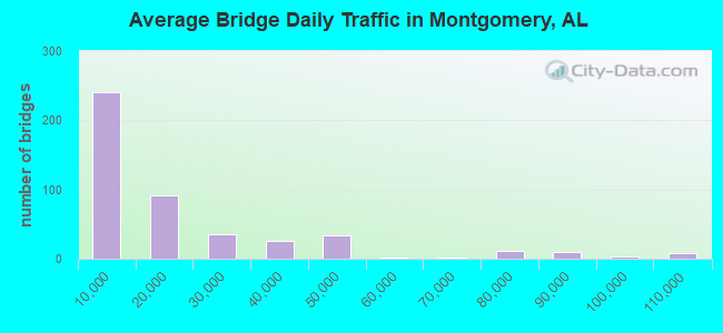
- 8,220,647Total average daily traffic
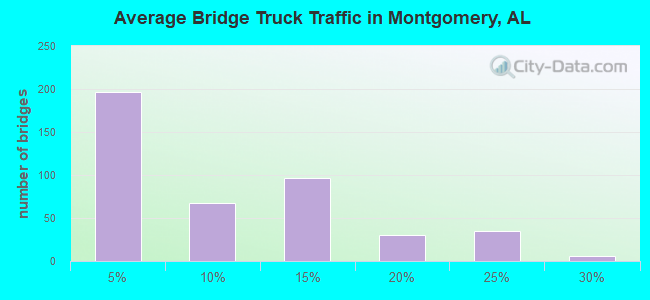
- 853,526Total average daily truck traffic
- National Bridge Inventory (NBI) Registered Bridges for Montgomery
- No street view available for this location
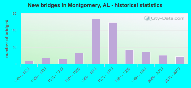
- New bridges - historical statistics
- 11910-1919
- 101920-1929
- 181930-1939
- 151940-1949
- 331950-1959
- 1331960-1969
- 1241970-1979
- 431980-1989
- 371990-1999
- 262000-2009
- 232010-2019
- 12020-2022
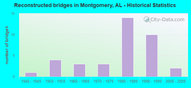
- Reconstructed bridges - Historical Statistics
- 11940-1949
- 41950-1959
- 31960-1969
- 31970-1979
- 141980-1989
- 101990-1999
- 22000-2009
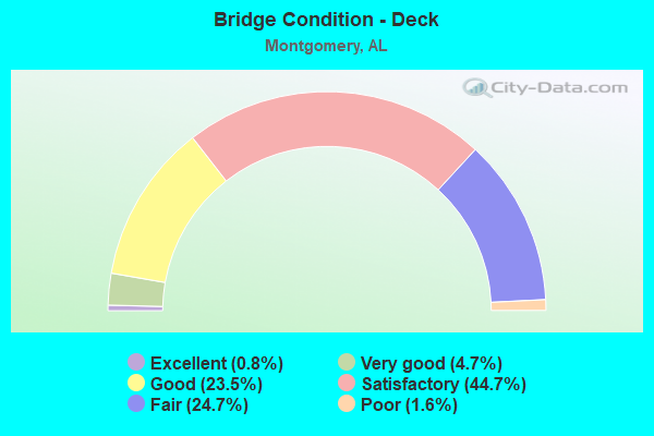
- Bridge Condition - Deck
- 0.8%Excellent
- 4.7%Very good
- 23.5%Good
- 44.7%Satisfactory
- 24.7%Fair
- 1.6%Poor
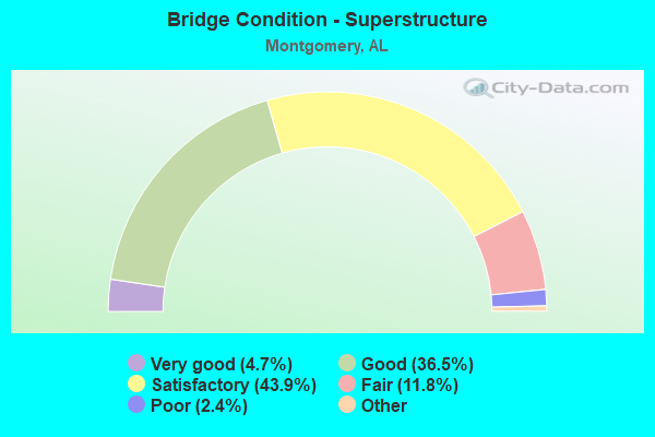
- Bridge Condition - Superstructure
- 4.7%Excellent
- 36.5%Very good
- 43.9%Good
- 11.8%Satisfactory
- 2.4%Fair
- 0.8%Poor
- 0.4%Serious
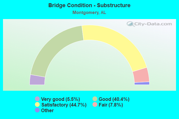
- Bridge Condition - Substructure
- 5.5%Excellent
- 40.4%Very good
- 44.7%Good
- 7.8%Satisfactory
- 1.6%Fair
- 0.8%Poor
- 0.4%Serious
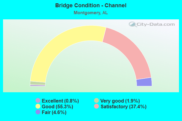
- Bridge Condition - Channel
- 0.8%Excellent
- 1.9%Very good
- 55.3%Good
- 37.4%Satisfactory
- 4.6%Fair
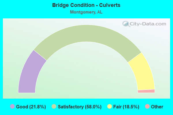
- Bridge Condition - Culverts
- 21.8%Excellent
- 58.0%Very good
- 18.5%Good
- 1.7%Satisfactory
- 18.5%Fair
Find on map >> Show street view
Structure Number: 993, Location: 0.1 MI.N.OF ANN ST. (Lat: 32.350256, Lng: -86.266689), Route carried "on" structure: Interstate 85, Year Built: 1969, Status: Open, Structure Length: 1.16m (3.81ft), Average Daily Traffic: 109,530 (year 2013), Truck Traffic: 11%, Average Future Daily Traffic: 144,356 (year 2033), Design Load: H 20, Features Intersected: STREAM
Minimum Vertical Clearance: 30+ m (98+ ft), Kilometerpoint: 4.987, Lanes on structure: 8, Base Highway Network: Yes, Owner: State Highway Agency, Approaching Roadway Width: 45.0m (147.6ft), Skew: 13 degrees, Material/Design: Concrete continuous, Design/Construction: Culvert, Number Of Spans In Main Unit: 3, Length of Maximum Span: 3.0m (9.8ft)
Condition: Channel: Good, Culverts: Satisfactory, Operating Rating: 88.9 metric tons, Method Used To Determine Operating Rating: Load Factor (LF), Inventory Rating: 88.9 metric tons, Method Used To Determine Inventory Rating: Load Factor (LF), Structural Evaluation: Equal to present minimum criteria, Waterway Adequacy: Superior to present desirable criteria, Approach Roadway Alignment: Better than present minimum criteria, Length Of Structure Improvement: 1.84m (6.04ft), Designated Inspection Frequency: Every 24 months, Inspection Date: April 2021, Bridge Improvement Cost: $3,786,000, Roadway Improvement Cost: $379,000, Total Project Cost: $4,165,000 ( Estimate for 2022)
Find on map >> Show street view
Structure Number: 9971, Location: 1 MI N OF SO. BY PASS (Lat: 32.332083, Lng: -86.357933), Route carried "on" structure: US 31, Year Built: 1969, Status: Open, Structure Length: 1.55m (5.09ft), Average Daily Traffic: 12,380 (year 2013), Truck Traffic: 12%, Average Future Daily Traffic: 15,903 (year 2033), Design Load: H 20, Features Intersected: DRAINAGE CANAL
Minimum Vertical Clearance: 30+ m (98+ ft), Kilometerpoint: 288.950, Lanes on structure: 2, Owner: State Highway Agency, Approaching Roadway Width: 13.4m (44.0ft), Material/Design: Concrete continuous, Design/Construction: Culvert, Number Of Spans In Main Unit: 4, Length of Maximum Span: 3.7m (12.1ft)
Condition: Channel: Satisfactory, Culverts: Fair, Operating Rating: 88.9 metric tons, Method Used To Determine Operating Rating: Load Factor (LF), Inventory Rating: 65.1 metric tons, Method Used To Determine Inventory Rating: Load Factor (LF), Structural Evaluation: Somewhat better than minimum adequacy, Waterway Adequacy: Better than present minimum criteria, Approach Roadway Alignment: Better than present minimum criteria, Length Of Structure Improvement: 2.23m (7.32ft), Designated Inspection Frequency: Every 24 months, Inspection Date: July 2021, Bridge Improvement Cost: $1,922,000, Roadway Improvement Cost: $192,000, Total Project Cost: $2,114,000 ( Estimate for 2022)
Find on map >> Show street view
Structure Number: 10205, Location: 2.6 MI N OF I65 (Lat: 32.365461, Lng: -86.278097), Route carried "on" structure: Interstate 85, Year Built: 1970, Year Reconstructed: 1994, Status: Open, Structure Length: 12.47m (40.91ft), Average Daily Traffic: 109,830 (year 2013), Truck Traffic: 10%, Average Future Daily Traffic: 144,752 (year 2033), Design Load: HS 20, Features Intersected: CHESTNUT STREET
Minimum Vertical Clearance: 30+ m (98+ ft), Kilometerpoint: 4.199, Lanes on structure: 10, Lanes under structure: 2, Base Highway Network: Yes, Owner: State Highway Agency, Approaching Roadway Width: 46.4m (152.2ft), Skew: 34 degrees, Material/Design: Steel, Design/Construction: Stringer/Multi-beam, Number Of Spans In Main Unit: 6, Length of Maximum Span: 25.0m (82.0ft), Curb-To-Curb Width: 44.0m (144.4ft), Out-to-Out Width: 46.0m (150.9ft)
Condition: Deck: Satisfactory, Superstructure: Satisfactory, Substructure: Satisfactory, Operating Rating: 50.6 metric tons, Method Used To Determine Operating Rating: Load Factor (LF), Inventory Rating: 30.3 metric tons, Method Used To Determine Inventory Rating: Load Factor (LF), Structural Evaluation: Equal to present minimum criteria, Deck Geometry: Better than present minimum criteria, Underclear: Superior to present desirable criteria, Approach Roadway Alignment: Better than present minimum criteria, Length Of Structure Improvement: 13.31m (43.67ft), Designated Inspection Frequency: Every 24 months, Inspection Date: May 2021, Bridge Improvement Cost: $13,688,000, Roadway Improvement Cost: $1,369,000, Total Project Cost: $15,057,000 ( Estimate for 2022), Deck Structure Type: Concrete Cast-file-Place
Find on map >> Show street view
Structure Number: 10503, Location: 0.7 MI.N.OF FAIRVIEW AVE. (Lat: 32.300000, Lng: -86.333333), Route carried "on" structure: Interstate 65, Year Built: 1971, Status: Open, Structure Length: 5.97m (19.59ft), Average Daily Traffic: 37,200 (year 2013), Truck Traffic: 12%, Average Future Daily Traffic: 47,129 (year 2033), Design Load: HS 20, Features Intersected: MILL ST
Minimum Vertical Clearance: 30+ m (98+ ft), Kilometerpoint: 274.924, Lanes on structure: 9, Lanes under structure: 2, Base Highway Network: Yes, Owner: State Highway Agency, Approaching Roadway Width: 48.8m (160.1ft), Skew: 30 degrees, Material/Design: Concrete continuous, Design/Construction: Tee Beam, Number Of Spans In Main Unit: 3, Length of Maximum Span: 22.6m (74.1ft), Curb-To-Curb Width: 20.5m (67.3ft), Out-to-Out Width: 45.8m (150.3ft)
Condition: Deck: Fair, Superstructure: Satisfactory, Substructure: Good, Operating Rating: 46.3 metric tons, Method Used To Determine Operating Rating: Load Factor (LF), Inventory Rating: 27.7 metric tons, Method Used To Determine Inventory Rating: Load Factor (LF), Structural Evaluation: Equal to present minimum criteria, Deck Geometry: High priority of replacement, Underclear: Superior to present desirable criteria, Approach Roadway Alignment: Better than present minimum criteria, Length Of Structure Improvement: 7.01m (23.00ft), Designated Inspection Frequency: Every 24 months, Inspection Date: April 2021, Bridge Improvement Cost: $7,210,000, Roadway Improvement Cost: $721,000, Total Project Cost: $7,931,000 ( Estimate for 2022), Deck Structure Type: Concrete Cast-file-Place
Find on map >> Show street view
Structure Number: 10505, Location: I65 N TO I85 N (Lat: 32.365000, Lng: -86.320000), Route carried "on" structure: Ramp Interstate 65, Year Built: 1971, Status: Open, Structure Length: 15.18m (49.80ft), Average Daily Traffic: 7,440 (year 2013), Truck Traffic: 12%, Average Future Daily Traffic: 9,425 (year 2033), Design Load: HS 20, Features Intersected: HOLT ST.AND W.JEFF DAVIS, Facility Carried by Structure: RAMP 51
Minimum Vertical Clearance: 30+ m (98+ ft), Kilometerpoint: 275.265, Lanes on structure: 2, Lanes under structure: 4, Base Highway Network: Yes, Owner: State Highway Agency, Approaching Roadway Width: 13.4m (44.0ft), Material/Design: Steel, Design/Construction: Stringer/Multi-beam, Number Of Spans In Main Unit: 4, Length of Maximum Span: 53.3m (174.9ft), Curb-To-Curb Width: 12.0m (39.4ft), Out-to-Out Width: 12.9m (42.3ft)
Condition: Deck: Fair, Superstructure: Satisfactory, Substructure: Satisfactory, Operating Rating: 74.9 metric tons, Method Used To Determine Operating Rating: Load Factor (LF), Inventory Rating: 44.9 metric tons, Method Used To Determine Inventory Rating: Load Factor (LF), Structural Evaluation: Equal to present minimum criteria, Deck Geometry: Superior to present desirable criteria, Underclear: Better than present minimum criteria, Approach Roadway Alignment: Better than present minimum criteria, Length Of Structure Improvement: 15.95m (52.33ft), Designated Inspection Frequency: Every 24 months, Inspection Date: May 2021, Bridge Improvement Cost: $4,593,000, Roadway Improvement Cost: $459,000, Total Project Cost: $5,052,000 ( Estimate for 2022), Deck Structure Type: Concrete Cast-file-Place
Find on map >> Show street view
Structure Number: 10506, Location: 0.2 MI.S.OF BELL ST (Lat: 32.375403, Lng: -86.321436), Route carried "on" structure: City street , Year Built: 1971, Status: Open, Structure Length: 8.11m (26.61ft), Average Daily Traffic: 8,664 (year 2003), Truck Traffic: 1%, Average Future Daily Traffic: 16,763 (year 2028), Design Load: HS 20, Features Intersected: I65, Facility Carried by Structure: HERRON ST
Minimum Vertical Clearance: 30+ m (98+ ft), Kilometerpoint: 0.129, Lanes on structure: 3, Lanes under structure: 4, Owner: State Highway Agency, Approaching Roadway Width: 12.2m (40.0ft), Material/Design: Steel, Design/Construction: Stringer/Multi-beam, Number Of Spans In Main Unit: 4, Length of Maximum Span: 21.3m (69.9ft), Curb or Sidewalk Widths: Left: 1.5m (4.9ft), Right: 1.5m (4.9ft), Curb-To-Curb Width: 12.2m (40.0ft), Out-to-Out Width: 15.2m (49.9ft)
Condition: Deck: Fair, Superstructure: Satisfactory, Substructure: Good, Operating Rating: 66.0 metric tons, Method Used To Determine Operating Rating: Load Factor (LF), Inventory Rating: 39.6 metric tons, Method Used To Determine Inventory Rating: Load Factor (LF), Structural Evaluation: Equal to present minimum criteria, Deck Geometry: Meets minimum limits, Underclear: Equal to present minimum criteria, Approach Roadway Alignment: Better than present minimum criteria, Length Of Structure Improvement: 9.11m (29.89ft), Designated Inspection Frequency: Every 24 months, Inspection Date: March 2021, Bridge Improvement Cost: $3,062,000, Roadway Improvement Cost: $306,000, Total Project Cost: $3,368,000 ( Estimate for 2022), Deck Structure Type: Concrete Cast-file-Place
Find on map >> Show street view
Structure Number: 10551, Location: FLATTOP - SNOWVILLE (Lat: 33.659300, Lng: -87.023500), Route carried "on" structure: County highway 12, Year Built: 1971, Status: Open, Structure Length: 20.60m (67.59ft), Average Daily Traffic: 3,000 (year 2021), Truck Traffic: 10%, Average Future Daily Traffic: 6,000 (year 2041), Design Load: HS 20, Features Intersected: BLCK WARRIOR-LOCUST FORK, Facility Carried by Structure: FLAT TOP ROAD
Minimum Vertical Clearance: 30+ m (98+ ft), Kilometerpoint: 0.010, Lanes on structure: 2, Owner: County Highway Agency, Approaching Roadway Width: 14.0m (45.9ft), Material/Design: Steel continuous, Design/Construction: Stringer/Multi-beam, Number Of Spans In Main Unit: 5, Number Of Approach Spans: 3, Length of Maximum Span: 30.5m (100.1ft), Curb or Sidewalk Widths: Left: 0.2m (0.7ft), Right: 0.2m (0.7ft), Curb-To-Curb Width: 13.4m (44.0ft), Out-to-Out Width: 14.6m (47.9ft)
Condition: Deck: Satisfactory, Superstructure: Satisfactory, Substructure: Good, Channel: Good, Operating Rating: 58.3 metric tons, Method Used To Determine Operating Rating: Load Factor (LF), Inventory Rating: 34.9 metric tons, Method Used To Determine Inventory Rating: Load Factor (LF), Structural Evaluation: Equal to present minimum criteria, Deck Geometry: Better than present minimum criteria, Waterway Adequacy: Better than present minimum criteria, Approach Roadway Alignment: Better than present minimum criteria, Length Of Structure Improvement: 20.60m (67.59ft), Designated Inspection Frequency: Every 24 months, Underwater Inspection Frequency: Every 48 months, Inspection Date: May 2021, Underwater Inspection Date: July 2018, Bridge Improvement Cost: $6,639,000, Roadway Improvement Cost: $664,000, Total Project Cost: $7,303,000 ( Estimate for 2022), Deck Structure Type: Concrete Cast-file-Place
Find on map >> Show street view
Structure Number: 10553, Location: CR 385 (Lat: 34.081567, Lng: -86.943203), Route carried "on" structure: County highway 13, Year Built: 1971, Status: Posted for load, Structure Length: 0.73m (2.40ft), Average Daily Traffic: 400 (year 1991), Truck Traffic: 5%, Average Future Daily Traffic: 600 (year 2035), Design Load: H 15, Features Intersected: BRANCH, Facility Carried by Structure: CO RT 385
Minimum Vertical Clearance: 30+ m (98+ ft), Kilometerpoint: 0.010, Lanes on structure: 2, Owner: County Highway Agency, Approaching Roadway Width: 7.3m (24.0ft), Material/Design: Concrete, Design/Construction: Channel Beam, Number Of Spans In Main Unit: 1, Length of Maximum Span: 7.3m (24.0ft), Curb-To-Curb Width: 7.3m (24.0ft), Out-to-Out Width: 7.8m (25.6ft)
Condition: Deck: Satisfactory, Superstructure: Good, Substructure: Good, Channel: Good, Operating Rating: 45.5 metric tons, Method Used To Determine Operating Rating: Load Factor (LF), Inventory Rating: 27.3 metric tons, Method Used To Determine Inventory Rating: Load Factor (LF), Structural Evaluation: Equal to present minimum criteria, Deck Geometry: Somewhat better than minimum adequacy, Waterway Adequacy: Better than present minimum criteria, Approach Roadway Alignment: Better than present minimum criteria, Bridge Posting: Required (Relationship of Operating Rating to Maximum Legal Load: 0.1 - 9.9% below), Length Of Structure Improvement: 1.38m (4.53ft), Designated Inspection Frequency: Every 24 months, Other Special Inspection Frequency: Every 12 months, Inspection Date: October 2020, Other Special Inspection Date: October 2021, Bridge Improvement Cost: $236,000, Roadway Improvement Cost: $24,000, Total Project Cost: $260,000 ( Estimate for 2022), Deck Structure Type: Concrete Precast Panels
Find on map >> Show street view
Structure Number: 10555, Location: 296' 5 WOODLINE DR (Lat: 30.630519, Lng: -88.165508), Route carried "on" structure: City street , Year Built: 1971, Status: Open, Structure Length: 1.20m (3.94ft), Average Daily Traffic: 6,440 (year 2021), Truck Traffic: 1%, Average Future Daily Traffic: 9,595 (year 2041), Design Load: H 15, Features Intersected: BRANCH(NO NAME), Facility Carried by Structure: LONGLEAF DRIVE
Minimum Vertical Clearance: 30+ m (98+ ft), Kilometerpoint: 0.249, Lanes on structure: 2, Owner: City or Municipal Highway Agency, Approaching Roadway Width: 8.0m (26.2ft), Skew: 4 degrees, Material/Design: Concrete, Design/Construction: Culvert, Number Of Spans In Main Unit: 3, Length of Maximum Span: 3.0m (9.8ft), Curb or Sidewalk Widths: Left: 0.2m (0.7ft), Right: 0.2m (0.7ft)
Condition: Channel: Fair, Culverts: Satisfactory, Operating Rating: 47.1 metric tons, Method Used To Determine Operating Rating: Load Factor (LF), Inventory Rating: 28.3 metric tons, Method Used To Determine Inventory Rating: Load Factor (LF), Structural Evaluation: Equal to present minimum criteria, Waterway Adequacy: Better than present minimum criteria, Approach Roadway Alignment: Better than present minimum criteria, Length Of Structure Improvement: 1.88m (6.17ft), Designated Inspection Frequency: Every 24 months, Inspection Date: November 2021, Bridge Improvement Cost: $1,007,000, Roadway Improvement Cost: $101,000, Total Project Cost: $1,108,000 ( Estimate for 2022)
Find on map >> Show street view
Structure Number: 10556, Location: 1.7 MI E JCT US 90 * 98 (Lat: 30.655317, Lng: -87.884064), Route carried "on" structure: US 90, Year Built: 1971, Status: Open, Structure Length: 1.37m (4.49ft), Average Daily Traffic: 17,409 (year 2019), Truck Traffic: 4%, Average Future Daily Traffic: 26,114 (year 2039), Design Load: H 15, Features Intersected: D'OLIVE CREEK
Minimum Vertical Clearance: 30+ m (98+ ft), Kilometerpoint: 74.181, Lanes on structure: 2, Owner: State Highway Agency, Approaching Roadway Width: 8.5m (27.9ft), Skew: 3 degrees, Material/Design: Concrete, Design/Construction: Culvert, Number Of Spans In Main Unit: 3, Length of Maximum Span: 3.7m (12.1ft)
Condition: Channel: Fair, Culverts: Fair, Operating Rating: 88.5 metric tons, Method Used To Determine Operating Rating: Load Factor (LF), Inventory Rating: 53.1 metric tons, Method Used To Determine Inventory Rating: Load Factor (LF), Structural Evaluation: Somewhat better than minimum adequacy, Waterway Adequacy: Somewhat better than minimum adequacy, Approach Roadway Alignment: Equal to present desirable criteria, Length Of Structure Improvement: 2.05m (6.73ft), Designated Inspection Frequency: Every 24 months, Inspection Date: November 2020, Bridge Improvement Cost: $1,170,000, Roadway Improvement Cost: $117,000, Total Project Cost: $1,287,000 ( Estimate for 2022)
Find on map >> Show street view
Structure Number: 10557, Location: 0.8 MI E JCT SR 181 (Lat: 30.652358, Lng: -87.840197), Route carried "on" structure: US 90, Year Built: 1971, Status: Open, Structure Length: 1.31m (4.30ft), Average Daily Traffic: 5,709 (year 2019), Truck Traffic: 3%, Average Future Daily Traffic: 8,563 (year 2039), Design Load: H 20, Features Intersected: TURKEY BRANCH
Minimum Vertical Clearance: 30+ m (98+ ft), Kilometerpoint: 78.476, Lanes on structure: 2, Owner: State Highway Agency, Approaching Roadway Width: 8.5m (27.9ft), Material/Design: Concrete, Design/Construction: Culvert, Number Of Spans In Main Unit: 4, Length of Maximum Span: 3.0m (9.8ft)
Condition: Channel: Satisfactory, Culverts: Satisfactory, Operating Rating: 63.2 metric tons, Method Used To Determine Operating Rating: Load Factor (LF), Inventory Rating: 37.8 metric tons, Method Used To Determine Inventory Rating: Load Factor (LF), Structural Evaluation: Equal to present minimum criteria, Waterway Adequacy: Equal to present minimum criteria, Approach Roadway Alignment: Equal to present desirable criteria, Length Of Structure Improvement: 1.98m (6.50ft), Designated Inspection Frequency: Every 24 months, Inspection Date: November 2020, Bridge Improvement Cost: $756,000, Roadway Improvement Cost: $76,000, Total Project Cost: $832,000 ( Estimate for 2022)
Find on map >> Show street view
Structure Number: 10559, Location: 3.5 MI E JCT SR 181 (Lat: 30.636594, Lng: -87.799664), Route carried "on" structure: US 90, Year Built: 1971, Status: Open, Structure Length: 10.36m (33.99ft), Average Daily Traffic: 5,709 (year 2019), Truck Traffic: 3%, Average Future Daily Traffic: 8,564 (year 2039), Design Load: HS 20, Features Intersected: FISH RIVER
Minimum Vertical Clearance: 30+ m (98+ ft), Kilometerpoint: 82.872, Lanes on structure: 2, Owner: State Highway Agency, Approaching Roadway Width: 8.4m (27.6ft), Material/Design: Prestressed concrete continuous, Design/Construction: Stringer/Multi-beam, Number Of Spans In Main Unit: 10, Length of Maximum Span: 10.4m (34.1ft), Curb-To-Curb Width: 13.4m (44.0ft), Out-to-Out Width: 14.6m (47.9ft)
Condition: Deck: Fair, Superstructure: Good, Substructure: Fair, Channel: Satisfactory, Operating Rating: 59.3 metric tons, Method Used To Determine Operating Rating: Load Factor (LF), Inventory Rating: 35.6 metric tons, Method Used To Determine Inventory Rating: Load Factor (LF), Structural Evaluation: Somewhat better than minimum adequacy, Deck Geometry: Equal to present minimum criteria, Waterway Adequacy: Equal to present minimum criteria, Approach Roadway Alignment: Better than present minimum criteria, Length Of Structure Improvement: 11.28m (37.01ft), Designated Inspection Frequency: Every 24 months, Inspection Date: October 2020, Bridge Improvement Cost: $3,635,000, Roadway Improvement Cost: $364,000, Total Project Cost: $3,999,000 ( Estimate for 2022), Deck Structure Type: Concrete Cast-file-Place
Find on map >> Show street view
Structure Number: 10621, Location: 2.0 MI W OF US 231 (Lat: 32.422500, Lng: -86.264167), Route carried "on" structure: Bypass State highway 152, Year Built: 1971, Status: Open, Structure Length: 0.91m (2.99ft), Average Daily Traffic: 23,320 (year 2013), Truck Traffic: 10%, Average Future Daily Traffic: 28,455 (year 2033), Design Load: HS 20, Features Intersected: STREAM
Minimum Vertical Clearance: 30+ m (98+ ft), Kilometerpoint: 7.493, Lanes on structure: 5, Base Highway Network: Yes, Owner: State Highway Agency, Approaching Roadway Width: 24.4m (80.1ft), Skew: 13 degrees, Material/Design: Concrete continuous, Design/Construction: Culvert, Number Of Spans In Main Unit: 2, Length of Maximum Span: 3.7m (12.1ft)
Condition: Channel: Good, Culverts: Satisfactory, Operating Rating: 88.9 metric tons, Method Used To Determine Operating Rating: Load Factor (LF), Inventory Rating: 88.9 metric tons, Method Used To Determine Inventory Rating: Load Factor (LF), Structural Evaluation: Equal to present minimum criteria, Waterway Adequacy: Superior to present desirable criteria, Approach Roadway Alignment: Better than present minimum criteria, Length Of Structure Improvement: 1.58m (5.18ft), Designated Inspection Frequency: Every 24 months, Inspection Date: November 2020, Bridge Improvement Cost: $1,405,000, Roadway Improvement Cost: $141,000, Total Project Cost: $1,546,000 ( Estimate for 2022)
Find on map >> Show street view
Structure Number: 10659, Location: 2.1 MI. S.W. CROSSVILLE (Lat: 33.719878, Lng: -88.026056), Route carried "on" structure: County highway , Year Built: 1961, Year Reconstructed: 1972, Status: Posted for load, Structure Length: 0.91m (2.99ft), Average Daily Traffic: 40 (year 1995), Average Future Daily Traffic: 40 (year 2032), Features Intersected: HELL'S CREEK, Facility Carried by Structure: LITTLE HELLS CK RD
Minimum Vertical Clearance: 30+ m (98+ ft), Kilometerpoint: 0.010, Lanes on structure: 1, Owner: County Highway Agency, Approaching Roadway Width: 6.1m (20.0ft), Material/Design: Steel, Design/Construction: Stringer/Multi-beam, Number Of Spans In Main Unit: 1, Length of Maximum Span: 9.1m (29.9ft), Curb-To-Curb Width: 4.3m (14.1ft), Out-to-Out Width: 4.9m (16.1ft)
Condition: Deck: Good, Superstructure: Satisfactory, Substructure: Fair, Channel: Satisfactory, Operating Rating: 23.9 metric tons, Method Used To Determine Operating Rating: Allowable Stress (AS), Inventory Rating: 13.3 metric tons, Method Used To Determine Inventory Rating: Allowable Stress (AS), Structural Evaluation: Meets minimum limits, Deck Geometry: Equal to present minimum criteria, Waterway Adequacy: Equal to present minimum criteria, Approach Roadway Alignment: Somewhat better than minimum adequacy, Bridge Posting: Required (Relationship of Operating Rating to Maximum Legal Load: 30.0 - 39.9% below), Length Of Structure Improvement: 1.59m (5.22ft), Designated Inspection Frequency: Every 24 months, Other Special Inspection Frequency: Every 12 months, Inspection Date: December 2020, Other Special Inspection Date: December 2021, Bridge Improvement Cost: $174,000, Roadway Improvement Cost: $17,000, Total Project Cost: $191,000 ( Estimate for 2022), Deck Structure Type: Wood or Timber, Wearing Surface/Protective System: Wearing Surface: Wood or Timber
Find on map >> Show street view
Structure Number: 10663, Location: WEST TUNNEL INTERCHANGE (Lat: 30.683011, Lng: -88.042764), Route carried "on" structure: Interstate 10, Year Built: 1972, Status: Open, Structure Length: 14.66m (48.10ft), Average Daily Traffic: 41,630 (year 2018), Truck Traffic: 13%, Average Future Daily Traffic: 62,445 (year 2038), Design Load: HS 20, Features Intersected: CANAL ST * JACKSON ST
Minimum Vertical Clearance: 30+ m (98+ ft), Kilometerpoint: 42.532, Lanes on structure: 4, Lanes under structure: 9, Base Highway Network: Yes, Owner: State Highway Agency, Approaching Roadway Width: 20.4m (66.9ft), Skew: 10 degrees, Material/Design: Steel, Design/Construction: Stringer/Multi-beam, Number Of Spans In Main Unit: 1, Number Of Approach Spans: 6, Length of Maximum Span: 37.8m (124.0ft), Curb-To-Curb Width: 19.3m (63.3ft), Out-to-Out Width: 20.4m (66.9ft)
Condition: Deck: Fair, Superstructure: Fair, Substructure: Fair, Operating Rating: 35.0 metric tons, Method Used To Determine Operating Rating: Load Factor (LF), Inventory Rating: 26.1 metric tons, Method Used To Determine Inventory Rating: Load Factor (LF), Structural Evaluation: Somewhat better than minimum adequacy, Deck Geometry: Somewhat better than minimum adequacy, Underclear: High priority of corrective action, Approach Roadway Alignment: Equal to present desirable criteria, Length Of Structure Improvement: 15.44m (50.66ft), Designated Inspection Frequency: Every 24 months, Inspection Date: April 2020, Bridge Improvement Cost: $6,989,000, Roadway Improvement Cost: $699,000, Total Project Cost: $7,688,000 ( Estimate for 2022), Deck Structure Type: Concrete Cast-file-Place
Find on map >> Show street view
Structure Number: 10666, Location: WEST TUNNEL INTERCHANGE (Lat: 30.683897, Lng: -88.041892), Route carried "on" structure: Ramp Interstate 10, Year Built: 1972, Status: Open, Structure Length: 64.65m (212.11ft), Average Daily Traffic: 27,236 (year 2018), Truck Traffic: 13%, Average Future Daily Traffic: 40,854 (year 2038), Design Load: HS 20, Features Intersected: ROYAL/MONROE ST'S
Minimum Vertical Clearance: 30+ m (98+ ft), Kilometerpoint: 42.648, Lanes on structure: 2, Lanes under structure: 4, Owner: State Highway Agency, Approaching Roadway Width: 18.6m (61.0ft), Skew: 9 degrees, Material/Design: Prestressed concrete, Design/Construction: Stringer/Multi-beam, Number Of Spans In Main Unit: 34, Length of Maximum Span: 26.8m (87.9ft), Curb-To-Curb Width: 11.9m (39.0ft), Out-to-Out Width: 13.2m (43.3ft)
Condition: Deck: Fair, Superstructure: Fair, Substructure: Fair, Operating Rating: 76.7 metric tons, Method Used To Determine Operating Rating: Load Factor (LF), Inventory Rating: 45.9 metric tons, Method Used To Determine Inventory Rating: Load Factor (LF), Structural Evaluation: Somewhat better than minimum adequacy, Deck Geometry: Superior to present desirable criteria, Underclear: High priority of corrective action, Approach Roadway Alignment: Somewhat better than minimum adequacy, Length Of Structure Improvement: 64.65m (212.11ft), Designated Inspection Frequency: Every 24 months, Inspection Date: April 2020, Bridge Improvement Cost: $19,061,000, Roadway Improvement Cost: $1,906,000, Total Project Cost: $20,967,000 ( Estimate for 2022), Deck Structure Type: Concrete Cast-file-Place
Find on map >> Show street view
Structure Number: 10675, Location: 2.2 MI S OF US 31 (Lat: 32.516747, Lng: -86.433439), Route carried "on" structure: Interstate 65, Year Built: 1972, Status: Open, Structure Length: 0.67m (2.20ft), Average Daily Traffic: 19,520 (year 2013), Truck Traffic: 23%, Average Future Daily Traffic: 24,730 (year 2033), Design Load: HS 20, Features Intersected: STREAM
Minimum Vertical Clearance: 30+ m (98+ ft), Kilometerpoint: 296.443, Lanes on structure: 2, Base Highway Network: Yes, Owner: State Highway Agency, Approaching Roadway Width: 14.6m (47.9ft), Skew: 14 degrees, Material/Design: Concrete continuous, Design/Construction: Culvert, Number Of Spans In Main Unit: 2, Length of Maximum Span: 2.1m (6.9ft)
Condition: Channel: Fair, Culverts: Fair, Operating Rating: 88.9 metric tons, Method Used To Determine Operating Rating: Load Factor (LF), Inventory Rating: 88.9 metric tons, Method Used To Determine Inventory Rating: Load Factor (LF), Structural Evaluation: Somewhat better than minimum adequacy, Waterway Adequacy: Superior to present desirable criteria, Approach Roadway Alignment: Better than present minimum criteria, Length Of Structure Improvement: 1.30m (4.27ft), Designated Inspection Frequency: Every 24 months, Inspection Date: January 2021, Bridge Improvement Cost: $2,177,000, Roadway Improvement Cost: $218,000, Total Project Cost: $2,395,000 ( Estimate for 2022)
Find on map >> Show street view
Structure Number: 10676, Location: 0.6 MI S OF US 31 (Lat: 32.542511, Lng: -86.451308), Route carried "on" structure: County highway 85, Year Built: 1972, Status: Open, Structure Length: 9.88m (32.41ft), Average Daily Traffic: 700 (year 2009), Truck Traffic: 2%, Average Future Daily Traffic: 1,000 (year 2029), Design Load: HS 20, Features Intersected: I65
Minimum Vertical Clearance: 30+ m (98+ ft), Kilometerpoint: 10.670, Lanes on structure: 2, Lanes under structure: 4, Owner: State Highway Agency, Approaching Roadway Width: 12.2m (40.0ft), Material/Design: Steel continuous, Design/Construction: Stringer/Multi-beam, Number Of Spans In Main Unit: 4, Length of Maximum Span: 27.4m (89.9ft), Curb-To-Curb Width: 10.4m (34.1ft), Out-to-Out Width: 11.5m (37.7ft)
Condition: Deck: Fair, Superstructure: Satisfactory, Substructure: Satisfactory, Operating Rating: 58.3 metric tons, Method Used To Determine Operating Rating: Load Factor (LF), Inventory Rating: 34.9 metric tons, Method Used To Determine Inventory Rating: Load Factor (LF), Structural Evaluation: Equal to present minimum criteria, Deck Geometry: Equal to present minimum criteria, Underclear: Better than present minimum criteria, Approach Roadway Alignment: Better than present minimum criteria, Length Of Structure Improvement: 10.81m (35.47ft), Designated Inspection Frequency: Every 24 months, Inspection Date: January 2021, Bridge Improvement Cost: $2,743,000, Roadway Improvement Cost: $274,000, Total Project Cost: $3,017,000 ( Estimate for 2022), Deck Structure Type: Concrete Cast-file-Place
Find on map >> Show street view
Structure Number: 10689, Location: 0.5 MI.N.OF FAIRVIEW AVE. (Lat: 32.358767, Lng: -86.321450), Route carried "on" structure: City street , Year Built: 1972, Status: Open, Structure Length: 9.69m (31.79ft), Average Daily Traffic: 1,390 (year 2003), Truck Traffic: 1%, Average Future Daily Traffic: 2,509 (year 2028), Design Load: HS 20, Features Intersected: I65, Facility Carried by Structure: EARLY ST.
Minimum Vertical Clearance: 30+ m (98+ ft), Kilometerpoint: 1.706, Lanes on structure: 2, Lanes under structure: 8, Owner: State Highway Agency, Approaching Roadway Width: 8.5m (27.9ft), Material/Design: Steel continuous, Design/Construction: Stringer/Multi-beam, Number Of Spans In Main Unit: 4, Length of Maximum Span: 26.5m (86.9ft), Curb or Sidewalk Widths: Left: 1.5m (4.9ft), Right: 1.5m (4.9ft), Curb-To-Curb Width: 15.8m (51.8ft), Out-to-Out Width: 19.5m (64.0ft)
Condition: Deck: Satisfactory, Superstructure: Satisfactory, Substructure: Satisfactory, Operating Rating: 42.5 metric tons, Method Used To Determine Operating Rating: Load Factor (LF), Inventory Rating: 25.5 metric tons, Method Used To Determine Inventory Rating: Load Factor (LF), Structural Evaluation: Equal to present minimum criteria, Deck Geometry: Superior to present desirable criteria, Underclear: Somewhat better than minimum adequacy, Approach Roadway Alignment: Better than present minimum criteria, Length Of Structure Improvement: 10.63m (34.88ft), Designated Inspection Frequency: Every 24 months, Inspection Date: March 2021, Bridge Improvement Cost: $4,666,000, Roadway Improvement Cost: $467,000, Total Project Cost: $5,133,000 ( Estimate for 2022), Deck Structure Type: Concrete Cast-file-Place
Find on map >> Show street view
Structure Number: 1069, Location: I65 AND I85 INTERCHANGE (Lat: 32.365000, Lng: -86.321667), Route carried "on" structure: Ramp Interstate 65, Year Built: 1972, Status: Temporarily open, Structure Length: 9.14m (29.99ft), Average Daily Traffic: 7,440 (year 2013), Truck Traffic: 12%, Average Future Daily Traffic: 9,425 (year 2033), Design Load: HS 20, Features Intersected: W.JEFF DAVIS AVE
Minimum Vertical Clearance: 30+ m (98+ ft), Kilometerpoint: 275.298, Lanes on structure: 1, Lanes under structure: 2, Base Highway Network: Yes, Owner: State Highway Agency, Approaching Roadway Width: 8.8m (28.9ft), Material/Design: Steel continuous, Design/Construction: Stringer/Multi-beam, Number Of Spans In Main Unit: 4, Length of Maximum Span: 27.4m (89.9ft), Curb-To-Curb Width: 7.9m (25.9ft), Out-to-Out Width: 9.1m (29.9ft)
Condition: Deck: Satisfactory, Superstructure: Poor, Substructure: Satisfactory, Operating Rating: 50.1 metric tons, Method Used To Determine Operating Rating: Load Factor (LF), Inventory Rating: 29.0 metric tons, Method Used To Determine Inventory Rating: Load Factor (LF), Structural Evaluation: Meets minimum limits, Deck Geometry: Equal to present desirable criteria, Underclear: Better than present minimum criteria, Approach Roadway Alignment: Meets minimum limits, Length Of Structure Improvement: 10.11m (33.17ft), Designated Inspection Frequency: Every 24 months, Other Special Inspection Frequency: Every 12 months, Inspection Date: April 2021, Other Special Inspection Date: April 2021, Bridge Improvement Cost: $2,010,000, Roadway Improvement Cost: $201,000, Total Project Cost: $2,211,000 ( Estimate for 2022), Deck Structure Type: Concrete Cast-file-Place
Find on map >> Show street view
Structure Number: 10691, Location: 0.4 MI.N.OF AL.RIVER (Lat: 32.390550, Lng: -86.323414), Route carried "on" structure: Ramp State highway 152, Year Built: 1972, Status: Open, Structure Length: 14.72m (48.29ft), Average Daily Traffic: 3,242 (year 2013), Truck Traffic: 8%, Average Future Daily Traffic: 3,955 (year 2033), Design Load: HS 20, Features Intersected: AL.RIVER RELIEF
Minimum Vertical Clearance: 30+ m (98+ ft), Kilometerpoint: 0.000, Lanes on structure: 1, Base Highway Network: Yes, Owner: State Highway Agency, Approaching Roadway Width: 7.6m (24.9ft), Material/Design: Steel continuous, Design/Construction: Stringer/Multi-beam, Number Of Spans In Main Unit: 6, Length of Maximum Span: 24.7m (81.0ft), Curb-To-Curb Width: 7.6m (24.9ft), Out-to-Out Width: 8.5m (27.9ft)
Condition: Deck: Fair, Superstructure: Satisfactory, Substructure: Good, Channel: Good, Operating Rating: 63.2 metric tons, Method Used To Determine Operating Rating: Load Factor (LF), Inventory Rating: 35.7 metric tons, Method Used To Determine Inventory Rating: Load Factor (LF), Structural Evaluation: Equal to present minimum criteria, Deck Geometry: Better than present minimum criteria, Waterway Adequacy: Superior to present desirable criteria, Approach Roadway Alignment: Better than present minimum criteria, Length Of Structure Improvement: 15.50m (50.85ft), Designated Inspection Frequency: Every 24 months, Inspection Date: Febuary 2021, Bridge Improvement Cost: $2,870,000, Roadway Improvement Cost: $287,000, Total Project Cost: $3,157,000 ( Estimate for 2022), Deck Structure Type: Concrete Cast-file-Place
Find on map >> Show street view
Structure Number: 10692, Location: 0.8 MI.N.OF AL.RIVER (Lat: 32.390072, Lng: -86.324128), Route carried "on" structure: Interstate 65, Year Built: 1972, Status: Open, Structure Length: 12.25m (40.19ft), Average Daily Traffic: 81,240 (year 2013), Truck Traffic: 14%, Average Future Daily Traffic: 102,925 (year 2033), Design Load: HS 20, Features Intersected: AL.RIVER RELIEF NO 1
Minimum Vertical Clearance: 30+ m (98+ ft), Kilometerpoint: 278.091, Lanes on structure: 4, Base Highway Network: Yes, Owner: State Highway Agency, Approaching Roadway Width: 42.3m (138.8ft), Skew: 30 degrees, Material/Design: Steel, Design/Construction: Stringer/Multi-beam, Number Of Spans In Main Unit: 5, Length of Maximum Span: 24.7m (81.0ft), Curb-To-Curb Width: 35.4m (116.1ft), Out-to-Out Width: 37.4m (122.7ft)
Condition: Deck: Fair, Superstructure: Satisfactory, Substructure: Good, Channel: Good, Operating Rating: 63.6 metric tons, Method Used To Determine Operating Rating: Load Factor (LF), Inventory Rating: 38.1 metric tons, Method Used To Determine Inventory Rating: Load Factor (LF), Structural Evaluation: Equal to present minimum criteria, Deck Geometry: Superior to present desirable criteria, Waterway Adequacy: Superior to present desirable criteria, Approach Roadway Alignment: Better than present minimum criteria, Length Of Structure Improvement: 13.10m (42.98ft), Designated Inspection Frequency: Every 24 months, Inspection Date: August 2021, Bridge Improvement Cost: $10,955,000, Roadway Improvement Cost: $1,096,000, Total Project Cost: $12,051,000 ( Estimate for 2022), Deck Structure Type: Concrete Cast-file-Place
Find on map >> Show street view
Structure Number: 10694, Location: 1.2 MI.N.OF AL.RIVER (Lat: 32.394269, Lng: -86.329022), Route carried "on" structure: Interstate 65, Year Built: 1972, Year Reconstructed: 1999, Status: Open, Structure Length: 14.51m (47.60ft), Average Daily Traffic: 40,620 (year 2013), Truck Traffic: 14%, Average Future Daily Traffic: 51,462 (year 2033), Design Load: HS 20, Features Intersected: AL.RIVER RELIEF NO 2
Minimum Vertical Clearance: 30+ m (98+ ft), Kilometerpoint: 278.751, Lanes on structure: 6, Base Highway Network: Yes, Owner: State Highway Agency, Approaching Roadway Width: 18.1m (59.4ft), Skew: 30 degrees, Material/Design: Concrete, Design/Construction: Tee Beam, Number Of Spans In Main Unit: 14, Length of Maximum Span: 10.4m (34.1ft), Curb-To-Curb Width: 17.6m (57.7ft), Out-to-Out Width: 38.3m (125.7ft)
Condition: Deck: Satisfactory, Superstructure: Fair, Substructure: Satisfactory, Channel: Good, Operating Rating: 39.1 metric tons, Method Used To Determine Operating Rating: Load Factor (LF), Inventory Rating: 23.4 metric tons, Method Used To Determine Inventory Rating: Load Factor (LF), Structural Evaluation: Somewhat better than minimum adequacy, Deck Geometry: High priority of replacement, Waterway Adequacy: Superior to present desirable criteria, Approach Roadway Alignment: Better than present minimum criteria, Length Of Structure Improvement: 15.29m (50.16ft), Designated Inspection Frequency: Every 24 months, Inspection Date: October 2021, Bridge Improvement Cost: $13,109,000, Roadway Improvement Cost: $1,311,000, Total Project Cost: $14,420,000 ( Estimate for 2022), Deck Structure Type: Concrete Cast-file-Place
Find on map >> Show street view
Structure Number: 10696, Location: 1.6 MI.N.OF AL.RIVER (Lat: 32.398775, Lng: -86.334494), Route carried "on" structure: Interstate 65, Year Built: 1972, Year Reconstructed: 1999, Status: Open, Structure Length: 8.29m (27.20ft), Average Daily Traffic: 40,620 (year 2013), Truck Traffic: 14%, Average Future Daily Traffic: 51,462 (year 2033), Design Load: HS 20, Features Intersected: AL.RIVER RELIEF NO.3
Minimum Vertical Clearance: 30+ m (98+ ft), Kilometerpoint: 279.472, Lanes on structure: 6, Base Highway Network: Yes, Owner: State Highway Agency, Approaching Roadway Width: 17.9m (58.7ft), Skew: 30 degrees, Material/Design: Concrete, Design/Construction: Tee Beam, Number Of Spans In Main Unit: 8, Length of Maximum Span: 10.4m (34.1ft), Curb-To-Curb Width: 17.6m (57.7ft), Out-to-Out Width: 38.3m (125.7ft)
Condition: Deck: Satisfactory, Superstructure: Satisfactory, Substructure: Good, Channel: Good, Operating Rating: 45.7 metric tons, Method Used To Determine Operating Rating: Load Factor (LF), Inventory Rating: 27.5 metric tons, Method Used To Determine Inventory Rating: Load Factor (LF), Structural Evaluation: Equal to present minimum criteria, Deck Geometry: High priority of replacement, Waterway Adequacy: Superior to present desirable criteria, Approach Roadway Alignment: Better than present minimum criteria, Length Of Structure Improvement: 9.29m (30.48ft), Designated Inspection Frequency: Every 24 months, Inspection Date: October 2021, Bridge Improvement Cost: $7,961,000, Roadway Improvement Cost: $796,000, Total Project Cost: $8,757,000 ( Estimate for 2022), Deck Structure Type: Concrete Cast-file-Place
Find on map >> Show street view
Structure Number: 10698, Location: 1.9 MI.N.OF AL.RIVER (Lat: 32.402081, Lng: -86.337875), Route carried "on" structure: Interstate 65, Year Built: 1972, Year Reconstructed: 1999, Status: Open, Structure Length: 17.62m (57.81ft), Average Daily Traffic: 40,620 (year 2013), Truck Traffic: 14%, Average Future Daily Traffic: 51,462 (year 2033), Design Load: HS 20, Features Intersected: AL.RIVER RELIEF NO.4
Minimum Vertical Clearance: 30+ m (98+ ft), Kilometerpoint: 279.949, Lanes on structure: 6, Base Highway Network: Yes, Owner: State Highway Agency, Approaching Roadway Width: 17.9m (58.7ft), Skew: 30 degrees, Material/Design: Concrete, Design/Construction: Tee Beam, Number Of Spans In Main Unit: 17, Length of Maximum Span: 10.4m (34.1ft), Curb-To-Curb Width: 17.5m (57.4ft), Out-to-Out Width: 38.3m (125.7ft)
Condition: Deck: Satisfactory, Superstructure: Fair, Substructure: Satisfactory, Channel: Good, Operating Rating: 39.1 metric tons, Method Used To Determine Operating Rating: Load Factor (LF), Inventory Rating: 23.4 metric tons, Method Used To Determine Inventory Rating: Load Factor (LF), Structural Evaluation: Somewhat better than minimum adequacy, Deck Geometry: High priority of replacement, Waterway Adequacy: Superior to present desirable criteria, Approach Roadway Alignment: Better than present minimum criteria, Length Of Structure Improvement: 18.32m (60.10ft), Designated Inspection Frequency: Every 24 months, Inspection Date: July 2021, Bridge Improvement Cost: $15,701,000, Roadway Improvement Cost: $1,570,000, Total Project Cost: $17,271,000 ( Estimate for 2022), Deck Structure Type: Concrete Cast-file-Place
Find on map >> Show street view
Structure Number: 107, Location: 2.2 MI.N.OF AL.RIVER (Lat: 32.404281, Lng: -86.340608), Route carried "on" structure: Interstate 65, Year Built: 1972, Year Reconstructed: 1999, Status: Open, Structure Length: 18.65m (61.19ft), Average Daily Traffic: 40,620 (year 2013), Truck Traffic: 14%, Average Future Daily Traffic: 51,462 (year 2033), Design Load: HS 20, Features Intersected: AL.RIVER RELIEF NO 5
Minimum Vertical Clearance: 30+ m (98+ ft), Kilometerpoint: 280.320, Lanes on structure: 6, Base Highway Network: Yes, Owner: State Highway Agency, Approaching Roadway Width: 17.8m (58.4ft), Skew: 30 degrees, Material/Design: Concrete, Design/Construction: Tee Beam, Number Of Spans In Main Unit: 18, Length of Maximum Span: 10.4m (34.1ft), Curb-To-Curb Width: 17.6m (57.7ft), Out-to-Out Width: 38.3m (125.7ft)
Condition: Deck: Satisfactory, Superstructure: Fair, Substructure: Satisfactory, Channel: Good, Operating Rating: 39.1 metric tons, Method Used To Determine Operating Rating: Load Factor (LF), Inventory Rating: 23.4 metric tons, Method Used To Determine Inventory Rating: Load Factor (LF), Structural Evaluation: Somewhat better than minimum adequacy, Deck Geometry: High priority of replacement, Waterway Adequacy: Superior to present desirable criteria, Approach Roadway Alignment: Better than present minimum criteria, Length Of Structure Improvement: 19.29m (63.29ft), Designated Inspection Frequency: Every 24 months, Inspection Date: October 2021, Bridge Improvement Cost: $16,536,000, Roadway Improvement Cost: $1,654,000, Total Project Cost: $18,190,000 ( Estimate for 2022), Deck Structure Type: Concrete Cast-file-Place
Find on map >> Show street view
Structure Number: 10702, Location: 2.5 MI.N.OF AL.RIVER (Lat: 32.407919, Lng: -86.344875), Route carried "on" structure: Interstate 65, Year Built: 1972, Status: Open, Structure Length: 9.33m (30.61ft), Average Daily Traffic: 40,620 (year 2013), Truck Traffic: 14%, Average Future Daily Traffic: 51,462 (year 2033), Design Load: HS 20, Features Intersected: AL.RIVER RELIEF NO 6
Minimum Vertical Clearance: 30+ m (98+ ft), Kilometerpoint: 280.863, Lanes on structure: 2, Base Highway Network: Yes, Owner: State Highway Agency, Approaching Roadway Width: 18.0m (59.1ft), Skew: 30 degrees, Material/Design: Concrete, Design/Construction: Tee Beam, Number Of Spans In Main Unit: 9, Length of Maximum Span: 10.4m (34.1ft), Curb-To-Curb Width: 17.6m (57.7ft), Out-to-Out Width: 38.3m (125.7ft)
Condition: Deck: Satisfactory, Superstructure: Fair, Substructure: Satisfactory, Channel: Good, Operating Rating: 39.1 metric tons, Method Used To Determine Operating Rating: Load Factor (LF), Inventory Rating: 23.4 metric tons, Method Used To Determine Inventory Rating: Load Factor (LF), Structural Evaluation: Somewhat better than minimum adequacy, Deck Geometry: Superior to present desirable criteria, Waterway Adequacy: Superior to present desirable criteria, Approach Roadway Alignment: Better than present minimum criteria, Length Of Structure Improvement: 10.29m (33.76ft), Designated Inspection Frequency: Every 24 months, Inspection Date: June 2021, Bridge Improvement Cost: $8,817,000, Roadway Improvement Cost: $882,000, Total Project Cost: $9,699,000 ( Estimate for 2022), Deck Structure Type: Concrete Cast-file-Place
Find on map >> Show street view
Structure Number: 10704, Location: 2.8 MI.OF AL.RIVER (Lat: 32.410842, Lng: -86.348439), Route carried "on" structure: Interstate 65, Year Built: 1972, Status: Open, Structure Length: 12.44m (40.81ft), Average Daily Traffic: 40,620 (year 2013), Truck Traffic: 14%, Average Future Daily Traffic: 51,462 (year 2033), Design Load: HS 20, Features Intersected: AL.RIVER RELIEF NO.7
Minimum Vertical Clearance: 30+ m (98+ ft), Kilometerpoint: 281.342, Lanes on structure: 2, Base Highway Network: Yes, Owner: State Highway Agency, Approaching Roadway Width: 17.9m (58.7ft), Skew: 30 degrees, Material/Design: Concrete, Design/Construction: Tee Beam, Number Of Spans In Main Unit: 12, Length of Maximum Span: 10.4m (34.1ft), Curb-To-Curb Width: 17.6m (57.7ft), Out-to-Out Width: 38.3m (125.7ft)
Condition: Deck: Fair, Superstructure: Fair, Substructure: Satisfactory, Channel: Good, Operating Rating: 39.1 metric tons, Method Used To Determine Operating Rating: Load Factor (LF), Inventory Rating: 23.4 metric tons, Method Used To Determine Inventory Rating: Load Factor (LF), Structural Evaluation: Somewhat better than minimum adequacy, Deck Geometry: Superior to present desirable criteria, Waterway Adequacy: Superior to present desirable criteria, Approach Roadway Alignment: Better than present minimum criteria, Length Of Structure Improvement: 13.28m (43.57ft), Designated Inspection Frequency: Every 24 months, Inspection Date: June 2021, Bridge Improvement Cost: $11,381,000, Roadway Improvement Cost: $1,138,000, Total Project Cost: $12,519,000 ( Estimate for 2022), Deck Structure Type: Concrete Cast-file-Place
Find on map >> Show street view
Structure Number: 10706, Location: 3.5 MI.N.OF AL.RIVER (Lat: 32.418017, Lng: -86.356850), Route carried "on" structure: Interstate 65, Year Built: 1972, Status: Open, Structure Length: 95.34m (312.80ft), Average Daily Traffic: 40,620 (year 2013), Truck Traffic: 14%, Average Future Daily Traffic: 51,462 (year 2033), Design Load: HS 20, Features Intersected: AL.RIVER RLF.8 * AL 143
Minimum Vertical Clearance: 30+ m (98+ ft), Kilometerpoint: 282.469, Lanes on structure: 6, Lanes under structure: 1, Base Highway Network: Yes, Owner: State Highway Agency, Approaching Roadway Width: 17.9m (58.7ft), Skew: 30 degrees, Material/Design: Concrete, Design/Construction: Tee Beam, Number Of Spans In Main Unit: 92, Length of Maximum Span: 10.4m (34.1ft), Curb-To-Curb Width: 17.6m (57.7ft), Out-to-Out Width: 38.3m (125.7ft)
Condition: Deck: Satisfactory, Superstructure: Fair, Substructure: Satisfactory, Channel: Good, Operating Rating: 39.1 metric tons, Method Used To Determine Operating Rating: Load Factor (LF), Inventory Rating: 23.4 metric tons, Method Used To Determine Inventory Rating: Load Factor (LF), Structural Evaluation: Somewhat better than minimum adequacy, Deck Geometry: High priority of replacement, Underclear: Meets minimum limits, Waterway Adequacy: Superior to present desirable criteria, Approach Roadway Alignment: Better than present minimum criteria, Length Of Structure Improvement: 95.34m (312.80ft), Designated Inspection Frequency: Every 24 months, Inspection Date: September 2021, Bridge Improvement Cost: $81,719,000, Roadway Improvement Cost: $8,172,000, Total Project Cost: $89,891,000 ( Estimate for 2022), Deck Structure Type: Concrete Cast-file-Place
Find on map >> Show street view
Structure Number: 10721, Location: RC BR. ON CO. PAVEDRD. 6 (Lat: 31.338119, Lng: -85.249758), Route carried "on" structure: County highway , Year Built: 1972, Status: Posted for load, Structure Length: 5.18m (16.99ft), Average Daily Traffic: 100 (year 2014), Average Future Daily Traffic: 130 (year 2034), Design Load: H 15, Features Intersected: OMUSSEE CREEK, Facility Carried by Structure: ROAD
Minimum Vertical Clearance: 30+ m (98+ ft), Kilometerpoint: 0.010, Lanes on structure: 2, Owner: County Highway Agency, Approaching Roadway Width: 7.3m (24.0ft), Material/Design: Concrete, Design/Construction: Tee Beam, Number Of Spans In Main Unit: 5, Length of Maximum Span: 10.4m (34.1ft), Curb-To-Curb Width: 6.6m (21.7ft), Out-to-Out Width: 7.3m (24.0ft)
Condition: Deck: Good, Superstructure: Good, Substructure: Satisfactory, Channel: Satisfactory, Operating Rating: 41.7 metric tons, Method Used To Determine Operating Rating: Load Factor (LF), Inventory Rating: 25.0 metric tons, Method Used To Determine Inventory Rating: Load Factor (LF), Structural Evaluation: Equal to present minimum criteria, Deck Geometry: Somewhat better than minimum adequacy, Waterway Adequacy: Better than present minimum criteria, Approach Roadway Alignment: Better than present minimum criteria, Bridge Posting: Required (Relationship of Operating Rating to Maximum Legal Load: 10.0 - 19.9% below), Length Of Structure Improvement: 6.20m (20.34ft), Designated Inspection Frequency: Every 24 months, Other Special Inspection Frequency: Every 12 months, Inspection Date: November 2020, Other Special Inspection Date: December 2021, Bridge Improvement Cost: $1,021,000, Roadway Improvement Cost: $102,000, Total Project Cost: $1,123,000 ( Estimate for 2022), Deck Structure Type: Concrete Cast-file-Place
Find on map >> Show street view
Structure Number: 10747, Location: 0.7 MI N OF MERIWETHER RD (Lat: 32.291850, Lng: -86.102600), Route carried "on" structure: County highway 12, Year Built: 1972, Status: Open, Structure Length: 1.46m (4.79ft), Average Daily Traffic: 550 (year 1988), Truck Traffic: 1%, Average Future Daily Traffic: 1,000 (year 2040), Design Load: H 15, Features Intersected: DRAINAGE RELIEF, Facility Carried by Structure: PIKE RD
Minimum Vertical Clearance: 30+ m (98+ ft), Kilometerpoint: 0.010, Lanes on structure: 2, Owner: City or Municipal Highway Agency, Approaching Roadway Width: 7.9m (25.9ft), Material/Design: Concrete, Design/Construction: Channel Beam, Number Of Spans In Main Unit: 2, Length of Maximum Span: 7.3m (24.0ft), Curb-To-Curb Width: 7.3m (24.0ft), Out-to-Out Width: 8.4m (27.6ft)
Condition: Deck: Satisfactory, Superstructure: Satisfactory, Substructure: Good, Channel: Good, Operating Rating: 69.8 metric tons, Method Used To Determine Operating Rating: Allowable Stress (AS), Inventory Rating: 45.3 metric tons, Method Used To Determine Inventory Rating: Allowable Stress (AS), Structural Evaluation: Equal to present minimum criteria, Deck Geometry: Meets minimum limits, Waterway Adequacy: Better than present minimum criteria, Approach Roadway Alignment: Equal to present desirable criteria, Length Of Structure Improvement: 2.14m (7.02ft), Designated Inspection Frequency: Every 24 months, Inspection Date: July 2020, Bridge Improvement Cost: $396,000, Roadway Improvement Cost: $40,000, Total Project Cost: $436,000 ( Estimate for 2022), Deck Structure Type: Concrete Precast Panels, Wearing Surface/Protective System: Wearing Surface: Bituminous
Find on map >> Show street view
Structure Number: 10752, Location: LIGON SPRINGS FAME RANCH (Lat: 34.583358, Lng: -87.703358), Route carried "on" structure: County highway 18, Year Built: 1972, Status: Temporarily open, Structure Length: 2.50m (8.20ft), Average Daily Traffic: 206 (year 2006), Truck Traffic: 10%, Average Future Daily Traffic: 500 (year 2042), Design Load: H 15, Features Intersected: LITTLE BEAR CREEK, Facility Carried by Structure: LIGON SPRINGS RD
Minimum Vertical Clearance: 30+ m (98+ ft), Kilometerpoint: 0.010, Lanes on structure: 2, Owner: County Highway Agency, Approaching Roadway Width: 6.1m (20.0ft), Skew: 3 degrees, Material/Design: Concrete, Design/Construction: Channel Beam, Number Of Spans In Main Unit: 3, Length of Maximum Span: 9.8m (32.2ft), Curb or Sidewalk Widths: Left: 0.3m (1.0ft), Right: 0.3m (1.0ft), Curb-To-Curb Width: 7.6m (24.9ft), Out-to-Out Width: 8.2m (26.9ft)
Condition: Deck: Satisfactory, Superstructure: Fair, Substructure: Fair, Channel: Satisfactory, Operating Rating: 9.1 metric tons, Method Used To Determine Operating Rating: Field evaluation and documented engineering judgment, Inventory Rating: 6.4 metric tons, Method Used To Determine Inventory Rating: Field evaluation and documented engineering judgment, Structural Evaluation: High priority of replacement, Deck Geometry: Somewhat better than minimum adequacy, Waterway Adequacy: Equal to present minimum criteria, Approach Roadway Alignment: Meets minimum limits, Length Of Structure Improvement: 3.38m (11.09ft), Designated Inspection Frequency: Every 24 months, Inspection Date: Febuary 2022, Bridge Improvement Cost: $603,000, Roadway Improvement Cost: $60,000, Total Project Cost: $663,000 ( Estimate for 2022), Deck Structure Type: Concrete Precast Panels
Find on map >> Show street view
Structure Number: 10755, Location: 1.8 MI E OF AL 51 (Lat: 31.784217, Lng: -85.524944), Route carried "on" structure: County highway 26, Year Built: 1972, Status: Posted for load, Structure Length: 3.11m (10.20ft), Average Daily Traffic: 125 (year 2017), Truck Traffic: 17%, Average Future Daily Traffic: 145 (year 2037), Design Load: H 15, Features Intersected: JACKSON CREEK, Facility Carried by Structure: PEANUT HOUSE RD
Minimum Vertical Clearance: 30+ m (98+ ft), Kilometerpoint: 0.010, Lanes on structure: 2, Owner: County Highway Agency, Approaching Roadway Width: 7.9m (25.9ft), Material/Design: Concrete, Design/Construction: Tee Beam, Number Of Spans In Main Unit: 3, Length of Maximum Span: 10.4m (34.1ft), Curb or Sidewalk Widths: Left: 0.4m (1.3ft), Right: 0.4m (1.3ft), Curb-To-Curb Width: 7.3m (24.0ft), Out-to-Out Width: 8.9m (29.2ft)
Condition: Deck: Good, Superstructure: Good, Substructure: Good, Channel: Good, Operating Rating: 37.2 metric tons, Method Used To Determine Operating Rating: Load Factor (LF), Inventory Rating: 21.4 metric tons, Method Used To Determine Inventory Rating: Load Factor (LF), Structural Evaluation: Equal to present minimum criteria, Deck Geometry: Somewhat better than minimum adequacy, Waterway Adequacy: Equal to present minimum criteria, Approach Roadway Alignment: Equal to present minimum criteria, Bridge Posting: Required (Relationship of Operating Rating to Maximum Legal Load: 10.0 - 19.9% below), Length Of Structure Improvement: 3.96m (12.99ft), Designated Inspection Frequency: Every 24 months, Other Special Inspection Frequency: Every 12 months, Inspection Date: March 2021, Other Special Inspection Date: March 2021, Bridge Improvement Cost: $788,000, Roadway Improvement Cost: $79,000, Total Project Cost: $867,000 ( Estimate for 2022), Deck Structure Type: Concrete Cast-file-Place
Find on map >> Show street view
Structure Number: 10756, Location: SEC25 T2S R6W (Lat: 34.843803, Lng: -87.106403), Route carried "on" structure: County highway 31, Year Built: 1972, Status: Open, Structure Length: 3.78m (12.40ft), Average Daily Traffic: 1,560 (year 2014), Truck Traffic: 1%, Average Future Daily Traffic: 2,300 (year 2034), Design Load: H 15, Features Intersected: BIG CR, Facility Carried by Structure: BAKER HILL RD
Minimum Vertical Clearance: 30+ m (98+ ft), Kilometerpoint: 0.010, Lanes on structure: 2, Owner: County Highway Agency, Approaching Roadway Width: 8.5m (27.9ft), Material/Design: Steel, Design/Construction: Stringer/Multi-beam, Number Of Spans In Main Unit: 2, Length of Maximum Span: 15.8m (51.8ft), Curb-To-Curb Width: 8.5m (27.9ft), Out-to-Out Width: 9.7m (31.8ft)
Condition: Deck: Good, Superstructure: Good, Substructure: Good, Channel: Good, Operating Rating: 44.2 metric tons, Method Used To Determine Operating Rating: Allowable Stress (AS), Inventory Rating: 27.3 metric tons, Method Used To Determine Inventory Rating: Allowable Stress (AS), Structural Evaluation: Equal to present minimum criteria, Deck Geometry: Somewhat better than minimum adequacy, Waterway Adequacy: Equal to present minimum criteria, Approach Roadway Alignment: Equal to present minimum criteria, Length Of Structure Improvement: 4.71m (15.45ft), Designated Inspection Frequency: Every 24 months, Underwater Inspection Frequency: Every 48 months, Inspection Date: October 2020, Underwater Inspection Date: October 2018, Bridge Improvement Cost: $1,002,000, Roadway Improvement Cost: $100,000, Total Project Cost: $1,102,000 ( Estimate for 2022), Deck Structure Type: Concrete Cast-file-Place
Find on map >> Show street view
Structure Number: 10757, Location: 2.2 MI EAST OF JCT SR #17 (Lat: 33.001431, Lng: -88.255836), Route carried "on" structure: County highway 36, Year Built: 1972, Status: Open, Structure Length: 1.55m (5.09ft), Average Daily Traffic: 50 (year 1998), Average Future Daily Traffic: 75 (year 2034), Design Load: H 15, Features Intersected: FENANCHE CREEK
Minimum Vertical Clearance: 30+ m (98+ ft), Kilometerpoint: 0.010, Lanes on structure: 2, Owner: County Highway Agency, Approaching Roadway Width: 9.1m (29.9ft), Material/Design: Concrete, Design/Construction: Channel Beam, Number Of Spans In Main Unit: 3, Length of Maximum Span: 5.8m (19.0ft), Curb-To-Curb Width: 7.1m (23.3ft), Out-to-Out Width: 7.7m (25.3ft)
Condition: Deck: Satisfactory, Superstructure: Satisfactory, Substructure: Fair, Channel: Good, Operating Rating: 47.9 metric tons, Method Used To Determine Operating Rating: Load Factor (LF), Inventory Rating: 28.8 metric tons, Method Used To Determine Inventory Rating: Load Factor (LF), Structural Evaluation: Somewhat better than minimum adequacy, Deck Geometry: Somewhat better than minimum adequacy, Waterway Adequacy: Equal to present minimum criteria, Approach Roadway Alignment: Equal to present minimum criteria, Length Of Structure Improvement: 2.23m (7.32ft), Designated Inspection Frequency: Every 24 months, Inspection Date: January 2022, Bridge Improvement Cost: $383,000, Roadway Improvement Cost: $38,000, Total Project Cost: $421,000 ( Estimate for 2022), Deck Structure Type: Concrete Precast Panels
Find on map >> Show street view
Structure Number: 10758, Location: 6.4 MI E TALLADEG CO LINE (Lat: 33.050278, Lng: -86.141722), Route carried "on" structure: State highway 38, Year Built: 1972, Status: Open, Structure Length: 0.99m (3.25ft), Average Daily Traffic: 12,925 (year 2018), Truck Traffic: 17%, Average Future Daily Traffic: 18,095 (year 2038), Design Load: H 20, Features Intersected: VARDAMAN CREEK
Minimum Vertical Clearance: 30+ m (98+ ft), Kilometerpoint: 86.480, Lanes on structure: 4, Base Highway Network: Yes, Owner: State Highway Agency, Approaching Roadway Width: 23.2m (76.1ft), Skew: 3 degrees, Material/Design: Concrete, Design/Construction: Culvert, Number Of Spans In Main Unit: 3, Length of Maximum Span: 3.2m (10.5ft)
Condition: Channel: Satisfactory, Culverts: Satisfactory, Operating Rating: 88.9 metric tons, Method Used To Determine Operating Rating: Load Factor (LF), Inventory Rating: 62.2 metric tons, Method Used To Determine Inventory Rating: Load Factor (LF), Structural Evaluation: Equal to present minimum criteria, Waterway Adequacy: Equal to present minimum criteria, Approach Roadway Alignment: Equal to present desirable criteria, Length Of Structure Improvement: 1.66m (5.45ft), Designated Inspection Frequency: Every 24 months, Inspection Date: July 2020, Bridge Improvement Cost: $1,930,000, Roadway Improvement Cost: $193,000, Total Project Cost: $2,123,000 ( Estimate for 2022)
Find on map >> Show street view
Structure Number: 10765, Location: 0.65 MI E OF US 11 (Lat: 34.503683, Lng: -85.690139), Route carried "on" structure: City street , Year Built: 1972, Status: Open, Structure Length: 2.07m (6.79ft), Average Daily Traffic: 90 (year 2020), Average Future Daily Traffic: 125 (year 2036), Design Load: H 15, Features Intersected: BIG WILLS CREEK, Facility Carried by Structure: 48TH ST
Minimum Vertical Clearance: 30+ m (98+ ft), Kilometerpoint: 0.010, Lanes on structure: 2, Owner: City or Municipal Highway Agency, Approaching Roadway Width: 7.9m (25.9ft), Material/Design: Concrete, Design/Construction: Channel Beam, Number Of Spans In Main Unit: 2, Length of Maximum Span: 10.4m (34.1ft), Curb or Sidewalk Widths: Left: 0.2m (0.7ft), Right: 0.2m (0.7ft), Curb-To-Curb Width: 7.4m (24.3ft), Out-to-Out Width: 8.0m (26.2ft)
Condition: Deck: Good, Superstructure: Good, Substructure: Satisfactory, Channel: Satisfactory, Operating Rating: 39.9 metric tons, Method Used To Determine Operating Rating: Load Factor (LF), Inventory Rating: 23.9 metric tons, Method Used To Determine Inventory Rating: Load Factor (LF), Structural Evaluation: Equal to present minimum criteria, Deck Geometry: Equal to present minimum criteria, Waterway Adequacy: Meets minimum limits, Approach Roadway Alignment: High priority of corrective action, Length Of Structure Improvement: 2.84m (9.32ft), Designated Inspection Frequency: Every 24 months, Inspection Date: March 2020, Bridge Improvement Cost: $506,000, Roadway Improvement Cost: $51,000, Total Project Cost: $557,000 ( Estimate for 2022), Deck Structure Type: Concrete Precast Panels
Find on map >> Show street view
Structure Number: 10766, Location: 1.2 MI SE OF FAIRVIEW (Lat: 31.239672, Lng: -86.012344), Route carried "on" structure: County highway 644, Year Built: 1972, Status: Posted for load, Structure Length: 3.11m (10.20ft), Average Daily Traffic: 103 (year 2020), Truck Traffic: 5%, Average Future Daily Traffic: 150 (year 2040), Design Load: H 15, Features Intersected: TIGHT EYE CREEK
Minimum Vertical Clearance: 30+ m (98+ ft), Kilometerpoint: 0.010, Lanes on structure: 2, Owner: County Highway Agency, Approaching Roadway Width: 8.5m (27.9ft), Material/Design: Concrete, Design/Construction: Tee Beam, Number Of Spans In Main Unit: 3, Length of Maximum Span: 10.4m (34.1ft), Curb-To-Curb Width: 7.3m (24.0ft), Out-to-Out Width: 8.2m (26.9ft)
Condition: Deck: Satisfactory, Superstructure: Good, Substructure: Satisfactory, Channel: Satisfactory, Operating Rating: 34.7 metric tons, Method Used To Determine Operating Rating: Load Factor (LF), Inventory Rating: 20.8 metric tons, Method Used To Determine Inventory Rating: Load Factor (LF), Structural Evaluation: Equal to present minimum criteria, Deck Geometry: Somewhat better than minimum adequacy, Waterway Adequacy: Better than present minimum criteria, Approach Roadway Alignment: Somewhat better than minimum adequacy, Bridge Posting: Required (Relationship of Operating Rating to Maximum Legal Load: 10.0 - 19.9% below), Length Of Structure Improvement: 3.96m (12.99ft), Designated Inspection Frequency: Every 24 months, Other Special Inspection Frequency: Every 12 months, Inspection Date: May 2020, Other Special Inspection Date: May 2021, Bridge Improvement Cost: $706,000, Roadway Improvement Cost: $71,000, Total Project Cost: $777,000 ( Estimate for 2022), Deck Structure Type: Concrete Cast-file-Place
Find on map >> Show street view
Structure Number: 10767, Location: 2.49 MILES SOUTH OF JAVA (Lat: 31.533322, Lng: -85.822878), Route carried "on" structure: County highway 127, Year Built: 1972, Status: Open, Structure Length: 0.85m (2.79ft), Average Daily Traffic: 150 (year 2020), Truck Traffic: 5%, Average Future Daily Traffic: 175 (year 2040), Design Load: H 10, Features Intersected: BRANCH
Minimum Vertical Clearance: 30+ m (98+ ft), Kilometerpoint: 0.010, Lanes on structure: 2, Owner: County Highway Agency, Approaching Roadway Width: 9.1m (29.9ft), Skew: 3 degrees, Material/Design: Concrete, Design/Construction: Culvert, Number Of Spans In Main Unit: 3, Length of Maximum Span: 2.7m (8.9ft)
Condition: Channel: Good, Culverts: Good, Operating Rating: 34.5 metric tons, Method Used To Determine Operating Rating: Load Factor (LF), Inventory Rating: 33.1 metric tons, Method Used To Determine Inventory Rating: Load Factor (LF), Structural Evaluation: Better than present minimum criteria, Waterway Adequacy: Better than present minimum criteria, Approach Roadway Alignment: Better than present minimum criteria, Length Of Structure Improvement: 1.51m (4.95ft), Designated Inspection Frequency: Every 24 months, Inspection Date: August 2020, Bridge Improvement Cost: $472,000, Roadway Improvement Cost: $47,000, Total Project Cost: $519,000 ( Estimate for 2022)