Bridge Statistics for Petersburg, Virginia (VA)
Condition, Traffic, Stress, Structural Evaluation, Project Costs
- National Bridge Inventory (NBI) Statistics
- 157Number of bridges
- 1,844ft / 562mTotal length
- $16,528,000Total costs
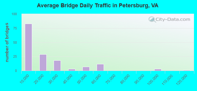
- 2,579,226Total average daily traffic
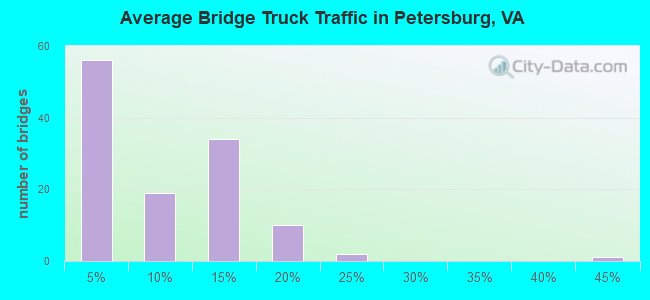
- 254,400Total average daily truck traffic
- National Bridge Inventory (NBI) Registered Bridges for Petersburg
- No street view available for this location
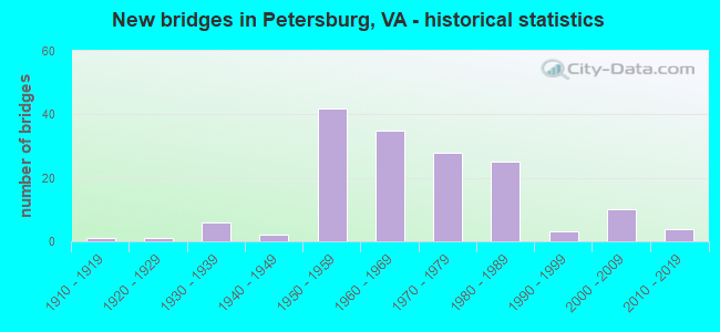
- New bridges - historical statistics
- 11910-1919
- 11920-1929
- 61930-1939
- 21940-1949
- 421950-1959
- 351960-1969
- 281970-1979
- 251980-1989
- 31990-1999
- 102000-2009
- 42010-2019
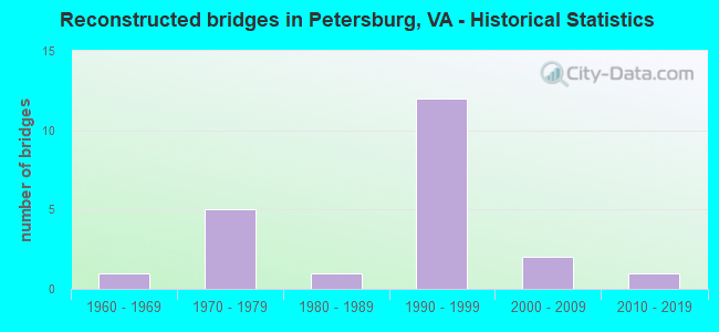
- Reconstructed bridges - Historical Statistics
- 11960-1969
- 51970-1979
- 11980-1989
- 121990-1999
- 22000-2009
- 12010-2019
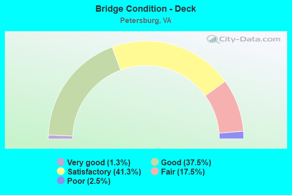
- Bridge Condition - Deck
- 1.3%Very good
- 37.5%Good
- 41.3%Satisfactory
- 17.5%Fair
- 2.5%Poor
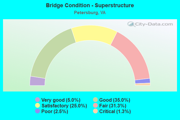
- Bridge Condition - Superstructure
- 5.0%Very good
- 35.0%Good
- 25.0%Satisfactory
- 31.3%Fair
- 2.5%Poor
- 1.3%Critical
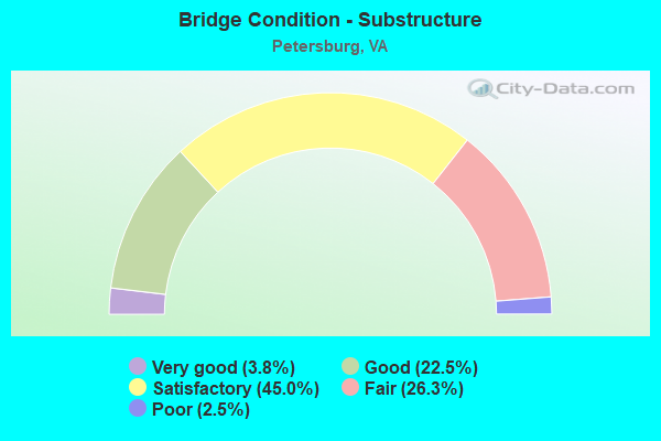
- Bridge Condition - Substructure
- 3.8%Very good
- 22.5%Good
- 45.0%Satisfactory
- 26.3%Fair
- 2.5%Poor
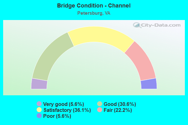
- Bridge Condition - Channel
- 5.6%Very good
- 30.6%Good
- 36.1%Satisfactory
- 22.2%Fair
- 5.6%Poor
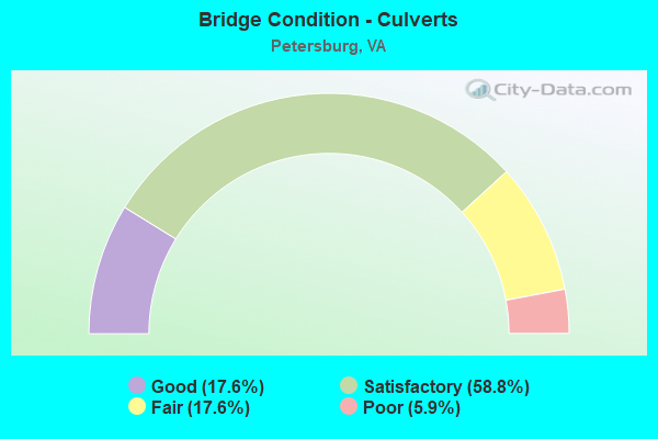
- Bridge Condition - Culverts
- 17.6%Good
- 58.8%Satisfactory
- 17.6%Fair
- 5.9%Poor
Find on map >> Show street view
Structure Number: 2942, Location: .70 FR 52 - 14.27 TO SCL (Lat: 37.061675, Lng: -81.192517), Route carried "on" structure: State highway 42, Year Built: 1949, Status: Posted for load, Structure Length: 1.37m (4.49ft), Average Daily Traffic: 416 (year 2020), Truck Traffic: 5%, Average Future Daily Traffic: 458 (year 2040), Design Load: HS 20, Features Intersected: BIG WALKER CK, Facility Carried by Structure: BLUE GRASS TRL
Minimum Vertical Clearance: 30+ m (98+ ft), Kilometerpoint: 52.231, Lanes on structure: 2, Owner: State Highway Agency, Approaching Roadway Width: 6.4m (21.0ft), Material/Design: Concrete, Design/Construction: Slab, Number Of Spans In Main Unit: 2, Length of Maximum Span: 7.0m (23.0ft), Curb or Sidewalk Widths: Left: 0.2m (0.7ft), Right: 0.2m (0.7ft), Curb-To-Curb Width: 7.0m (23.0ft), Out-to-Out Width: 7.9m (25.9ft)
Condition: Deck: Fair, Superstructure: Fair, Substructure: Satisfactory, Channel: Fair, Operating Rating: 34.5 metric tons, Method Used To Determine Operating Rating: Load and Resistance Factor (LRFR), Inventory Rating: 27.2 metric tons, Method Used To Determine Inventory Rating: Load Factor (LF), Structural Evaluation: Somewhat better than minimum adequacy, Deck Geometry: Meets minimum limits, Waterway Adequacy: Better than present minimum criteria, Approach Roadway Alignment: Better than present minimum criteria, Length Of Structure Improvement: 1.37m (4.49ft), Designated Inspection Frequency: Every 24 months, Inspection Date: Febuary 2021, Bridge Improvement Cost: $75,000, Roadway Improvement Cost: $15,000, Total Project Cost: $117,000 ( Estimate for 2015), Deck Structure Type: Concrete Cast-file-Place, Wearing Surface/Protective System: Wearing Surface: Bituminous
Find on map >> Show street view
Structure Number: 5906, Location: 0.34 Fr 670 & 0.11 To 603 (Lat: 37.193519, Lng: -77.470683), Route carried "on" structure: US 1, Year Built: 1984, Status: Open, Structure Length: 4.79m (15.72ft), Average Daily Traffic: 10,169 (year 2020), Truck Traffic: 3%, Average Future Daily Traffic: 14,237 (year 2040), Design Load: HS 20+Mod, Features Intersected: NORFOLK & SOUTHERN R.R., Facility Carried by Structure: BOYDTON PLANK ROAD
Minimum Vertical Clearance: 30+ m (98+ ft), Kilometerpoint: 105.840, Lanes on structure: 3, Owner: State Highway Agency, Approaching Roadway Width: 15.8m (51.8ft), Skew: 2 degrees, Material/Design: Steel, Design/Construction: Stringer/Multi-beam, Number Of Spans In Main Unit: 3, Length of Maximum Span: 16.8m (55.1ft), Curb-To-Curb Width: 15.4m (50.5ft), Out-to-Out Width: 16.4m (53.8ft)
Condition: Deck: Satisfactory, Superstructure: Good, Substructure: Satisfactory, Operating Rating: 68.0 metric tons, Method Used To Determine Operating Rating: Load and Resistance Factor (LRFR), Inventory Rating: 52.6 metric tons, Method Used To Determine Inventory Rating: Load and Resistance Factor (LRFR), Structural Evaluation: Equal to present minimum criteria, Deck Geometry: Equal to present minimum criteria, Underclear: Better than present minimum criteria, Approach Roadway Alignment: Equal to present desirable criteria, Designated Inspection Frequency: Every 24 months, Inspection Date: October 2020, Deck Structure Type: Concrete Precast Panels, Wearing Surface/Protective System: Deck Protection: Epoxy Coated Reinforcing
Find on map >> Show street view
Structure Number: 592, Location: 0.28 Fr 142 & 1.21 To 226 (Lat: 37.198728, Lng: -77.463614), Route carried "on" structure: US 1, Year Built: 1968, Year Reconstructed: 1996, Status: Open, Structure Length: 10.74m (35.24ft), Average Daily Traffic: 7,798 (year 2020), Truck Traffic: 14%, Average Future Daily Traffic: 10,917 (year 2040), Design Load: HS 20+Mod, Features Intersected: INTERSTATE-85, Facility Carried by Structure: BOYDTON PLANK ROAD
Minimum Vertical Clearance: 30+ m (98+ ft), Kilometerpoint: 106.651, Lanes on structure: 6, Lanes under structure: 6, Base Highway Network: Yes, Owner: State Highway Agency, Approaching Roadway Width: 11.6m (38.1ft), Skew: 3 degrees, Material/Design: Steel, Design/Construction: Stringer/Multi-beam, Number Of Spans In Main Unit: 4, Length of Maximum Span: 31.2m (102.4ft), Curb or Sidewalk Widths: Left: 0.2m (0.7ft), Right: 0.2m (0.7ft), Curb-To-Curb Width: 13.6m (44.6ft), Out-to-Out Width: 14.6m (47.9ft)
Condition: Deck: Fair, Superstructure: Fair, Substructure: Fair, Operating Rating: 59.0 metric tons, Method Used To Determine Operating Rating: Load and Resistance Factor (LRFR), Inventory Rating: 45.4 metric tons, Method Used To Determine Inventory Rating: Load and Resistance Factor (LRFR), Structural Evaluation: Somewhat better than minimum adequacy, Deck Geometry: High priority of replacement, Underclear: Equal to present minimum criteria, Approach Roadway Alignment: Equal to present desirable criteria, Designated Inspection Frequency: Every 24 months, Inspection Date: November 2020, Deck Structure Type: Concrete Cast-file-Place, Wearing Surface/Protective System: Wearing Surface: Latex Concrete
Find on map >> Show street view
Structure Number: 5951, Location: .9 FR 460 & 1.0 TO 1 (Lat: 37.195539, Lng: -77.480961), Route carried "on" structure: Interstate 85, Year Built: 1968, Status: Open, Structure Length: 6.60m (21.65ft), Average Daily Traffic: 19,128 (year 2020), Truck Traffic: 15%, Average Future Daily Traffic: 26,779 (year 2040), Design Load: HS 20+Mod, Features Intersected: NS RAILWAY
Minimum Vertical Clearance: 30+ m (98+ ft), Kilometerpoint: 101.303, Lanes on structure: 2, Base Highway Network: Yes, Owner: State Highway Agency, Approaching Roadway Width: 11.7m (38.4ft), Skew: 4 degrees, Material/Design: Steel continuous, Design/Construction: Stringer/Multi-beam, Number Of Spans In Main Unit: 3, Length of Maximum Span: 21.1m (69.2ft), Curb-To-Curb Width: 11.8m (38.7ft), Out-to-Out Width: 12.8m (42.0ft)
Condition: Deck: Good, Superstructure: Satisfactory, Substructure: Satisfactory, Operating Rating: 71.7 metric tons, Method Used To Determine Operating Rating: Load and Resistance Factor (LRFR), Inventory Rating: 55.2 metric tons, Method Used To Determine Inventory Rating: Load and Resistance Factor (LRFR), Structural Evaluation: Equal to present minimum criteria, Deck Geometry: Equal to present minimum criteria, Underclear: Somewhat better than minimum adequacy, Approach Roadway Alignment: Equal to present desirable criteria, Designated Inspection Frequency: Every 24 months, Inspection Date: March 2020, Deck Structure Type: Concrete Cast-file-Place, Wearing Surface/Protective System: Deck Protection: Epoxy Coated Reinforcing
Find on map >> Show street view
Structure Number: 5952, Location: 0.9 FR 460 & 1.0 TO 1 (Lat: 37.195631, Lng: -77.481397), Route carried "on" structure: Interstate 85, Year Built: 1968, Status: Open, Structure Length: 6.60m (21.65ft), Average Daily Traffic: 18,683 (year 2020), Truck Traffic: 15%, Average Future Daily Traffic: 26,156 (year 2040), Design Load: HS 20+Mod, Features Intersected: NS RAILWAY
Minimum Vertical Clearance: 30+ m (98+ ft), Kilometerpoint: 101.270, Lanes on structure: 2, Base Highway Network: Yes, Owner: State Highway Agency, Approaching Roadway Width: 12.3m (40.4ft), Skew: 4 degrees, Material/Design: Steel, Design/Construction: Stringer/Multi-beam, Number Of Spans In Main Unit: 3, Length of Maximum Span: 21.1m (69.2ft), Curb or Sidewalk Widths: Left: 0.2m (0.7ft), Right: 0.2m (0.7ft), Curb-To-Curb Width: 11.8m (38.7ft), Out-to-Out Width: 12.8m (42.0ft)
Condition: Deck: Satisfactory, Superstructure: Satisfactory, Substructure: Satisfactory, Operating Rating: 71.3 metric tons, Method Used To Determine Operating Rating: Load and Resistance Factor (LRFR), Inventory Rating: 55.0 metric tons, Method Used To Determine Inventory Rating: Load and Resistance Factor (LRFR), Structural Evaluation: Equal to present minimum criteria, Deck Geometry: Equal to present minimum criteria, Underclear: Somewhat better than minimum adequacy, Approach Roadway Alignment: Equal to present desirable criteria, Designated Inspection Frequency: Every 24 months, Inspection Date: March 2020, Deck Structure Type: Concrete Cast-file-Place, Wearing Surface/Protective System: Deck Protection: Epoxy Coated Reinforcing
Find on map >> Show street view
Structure Number: 5953, Location: 7.46 FR 703 & .10 TO 460 (Lat: 37.179608, Lng: -77.492994), Route carried "on" structure: Interstate 85, Year Built: 1968, Status: Open, Structure Length: 8.70m (28.54ft), Average Daily Traffic: 12,477 (year 2020), Truck Traffic: 13%, Average Future Daily Traffic: 17,468 (year 2040), Design Load: HS 20+Mod, Features Intersected: RTE 1 (BOYDTON PLANK RD)
Minimum Vertical Clearance: 30+ m (98+ ft), Kilometerpoint: 99.211, Lanes on structure: 2, Lanes under structure: 3, Base Highway Network: Yes, Owner: State Highway Agency, Approaching Roadway Width: 13.4m (44.0ft), Skew: 4 degrees, Material/Design: Steel, Design/Construction: Stringer/Multi-beam, Number Of Spans In Main Unit: 4, Length of Maximum Span: 22.6m (74.1ft), Curb or Sidewalk Widths: Left: 0.2m (0.7ft), Right: 0.2m (0.7ft), Curb-To-Curb Width: 10.0m (32.8ft), Out-to-Out Width: 11.0m (36.1ft)
Condition: Deck: Satisfactory, Superstructure: Fair, Substructure: Fair, Operating Rating: 95.3 metric tons, Method Used To Determine Operating Rating: Load and Resistance Factor (LRFR), Inventory Rating: 73.5 metric tons, Method Used To Determine Inventory Rating: Load and Resistance Factor (LRFR), Structural Evaluation: Somewhat better than minimum adequacy, Deck Geometry: Meets minimum limits, Underclear: Meets minimum limits, Approach Roadway Alignment: Equal to present desirable criteria, Designated Inspection Frequency: Every 24 months, Inspection Date: September 2020, Deck Structure Type: Concrete Cast-file-Place
Find on map >> Show street view
Structure Number: 5955, Location: 6.90 FR 605 & .03 TO 460 (Lat: 37.179353, Lng: -77.493325), Route carried "on" structure: Interstate 85, Year Built: 1968, Status: Open, Structure Length: 9.10m (29.86ft), Average Daily Traffic: 12,663 (year 2020), Truck Traffic: 13%, Average Future Daily Traffic: 17,728 (year 2040), Design Load: HS 20+Mod, Features Intersected: RTE 1 (BOYDTON PLANK RD)
Minimum Vertical Clearance: 30+ m (98+ ft), Kilometerpoint: 99.179, Lanes on structure: 2, Lanes under structure: 3, Base Highway Network: Yes, Owner: State Highway Agency, Approaching Roadway Width: 13.4m (44.0ft), Skew: 5 degrees, Material/Design: Steel, Design/Construction: Stringer/Multi-beam, Number Of Spans In Main Unit: 4, Length of Maximum Span: 23.3m (76.4ft), Curb or Sidewalk Widths: Left: 0.2m (0.7ft), Right: 0.2m (0.7ft), Curb-To-Curb Width: 10.0m (32.8ft), Out-to-Out Width: 11.0m (36.1ft)
Condition: Deck: Satisfactory, Superstructure: Fair, Substructure: Fair, Operating Rating: 92.5 metric tons, Method Used To Determine Operating Rating: Load and Resistance Factor (LRFR), Inventory Rating: 71.7 metric tons, Method Used To Determine Inventory Rating: Load and Resistance Factor (LRFR), Structural Evaluation: Somewhat better than minimum adequacy, Deck Geometry: Meets minimum limits, Underclear: Meets minimum limits, Approach Roadway Alignment: Equal to present desirable criteria, Designated Inspection Frequency: Every 24 months, Inspection Date: September 2020, Deck Structure Type: Concrete Cast-file-Place
Find on map >> Show street view
Structure Number: 5957, Location: 0.72 Fr 460 &0.82 To Rt.1 (Lat: 37.197533, Lng: -77.476139), Route carried "on" structure: Interstate 85, Year Built: 1968, Status: Open, Structure Length: 5.55m (18.21ft), Average Daily Traffic: 19,128 (year 2020), Truck Traffic: 16%, Average Future Daily Traffic: 26,779 (year 2040), Design Load: HS 20+Mod, Features Intersected: STERLING ROAD (RTE. 603)
Minimum Vertical Clearance: 30+ m (98+ ft), Kilometerpoint: 101.785, Lanes on structure: 2, Lanes under structure: 2, Base Highway Network: Yes, Owner: State Highway Agency, Approaching Roadway Width: 13.4m (44.0ft), Skew: 4 degrees, Material/Design: Steel, Design/Construction: Stringer/Multi-beam, Number Of Spans In Main Unit: 3, Length of Maximum Span: 18.8m (61.7ft), Curb or Sidewalk Widths: Left: 0.2m (0.7ft), Right: 0.2m (0.7ft), Curb-To-Curb Width: 11.8m (38.7ft), Out-to-Out Width: 12.8m (42.0ft)
Condition: Deck: Satisfactory, Superstructure: Satisfactory, Substructure: Good, Operating Rating: 71.4 metric tons, Method Used To Determine Operating Rating: Load and Resistance Factor (LRFR), Inventory Rating: 55.1 metric tons, Method Used To Determine Inventory Rating: Load and Resistance Factor (LRFR), Structural Evaluation: Equal to present minimum criteria, Deck Geometry: Equal to present minimum criteria, Underclear: Equal to present minimum criteria, Approach Roadway Alignment: Equal to present desirable criteria, Designated Inspection Frequency: Every 24 months, Inspection Date: March 2020, Deck Structure Type: Concrete Cast-file-Place, Wearing Surface/Protective System: Deck Protection: Epoxy Coated Reinforcing
Find on map >> Show street view
Structure Number: 5959, Location: 0.70 Fr 460 &0.39 To Rte1 (Lat: 37.197711, Lng: -77.476394), Route carried "on" structure: Interstate 85, Year Built: 1968, Status: Open, Structure Length: 4.95m (16.24ft), Average Daily Traffic: 18,683 (year 2020), Truck Traffic: 13%, Average Future Daily Traffic: 26,156 (year 2040), Design Load: HS 20+Mod, Features Intersected: STERLING ROAD (RTE. 603)
Minimum Vertical Clearance: 30+ m (98+ ft), Kilometerpoint: 101.753, Lanes on structure: 2, Lanes under structure: 2, Base Highway Network: Yes, Owner: State Highway Agency, Approaching Roadway Width: 13.4m (44.0ft), Skew: 5 degrees, Material/Design: Steel, Design/Construction: Stringer/Multi-beam, Number Of Spans In Main Unit: 3, Length of Maximum Span: 17.0m (55.8ft), Curb or Sidewalk Widths: Left: 0.2m (0.7ft), Right: 0.2m (0.7ft), Curb-To-Curb Width: 11.8m (38.7ft), Out-to-Out Width: 12.8m (42.0ft)
Condition: Deck: Fair, Superstructure: Fair, Substructure: Satisfactory, Operating Rating: 89.8 metric tons, Method Used To Determine Operating Rating: Load and Resistance Factor (LRFR), Inventory Rating: 78.0 metric tons, Method Used To Determine Inventory Rating: Load and Resistance Factor (LRFR), Structural Evaluation: Somewhat better than minimum adequacy, Deck Geometry: Equal to present minimum criteria, Underclear: Somewhat better than minimum adequacy, Approach Roadway Alignment: Equal to present desirable criteria, Designated Inspection Frequency: Every 24 months, Inspection Date: March 2020, Deck Structure Type: Concrete Cast-file-Place, Wearing Surface/Protective System: Deck Protection: Epoxy Coated Reinforcing
Find on map >> Show street view
Structure Number: 5977, Location: .52 Fr 1 & 0.51 SCL Petg (Lat: 37.199058, Lng: -77.454664), Route carried "on" structure: Interstate 85, Year Built: 1958, Year Reconstructed: 1996, Status: Open, Structure Length: 2.88m (9.45ft), Average Daily Traffic: 47,807 (year 2020), Truck Traffic: 13%, Average Future Daily Traffic: 65,604 (year 2040), Design Load: HS 20+Mod, Features Intersected: ROUTE 319 (SEVENTH AVE)
Minimum Vertical Clearance: 30+ m (98+ ft), Kilometerpoint: 103.716, Lanes on structure: 4, Lanes under structure: 2, Base Highway Network: Yes, Owner: State Highway Agency, Approaching Roadway Width: 27.6m (90.6ft), Skew: 30 degrees, Material/Design: Steel, Design/Construction: Stringer/Multi-beam, Number Of Spans In Main Unit: 3, Length of Maximum Span: 11.6m (38.1ft), Curb-To-Curb Width: 27.6m (90.6ft), Out-to-Out Width: 29.3m (96.1ft)
Condition: Deck: Satisfactory, Superstructure: Good, Substructure: Satisfactory, Operating Rating: 71.8 metric tons, Method Used To Determine Operating Rating: Load and Resistance Factor (LRFR), Inventory Rating: 55.3 metric tons, Method Used To Determine Inventory Rating: Load and Resistance Factor (LRFR), Structural Evaluation: Equal to present minimum criteria, Deck Geometry: Superior to present desirable criteria, Underclear: Meets minimum limits, Approach Roadway Alignment: Equal to present desirable criteria, Designated Inspection Frequency: Every 24 months, Inspection Date: November 2020, Deck Structure Type: Concrete Cast-file-Place, Wearing Surface/Protective System: Wearing Surface: Epoxy Overlay, Deck Protection: Epoxy Coated Reinforcing
Find on map >> Show street view
Structure Number: 5998, Location: 1.21 Fr 226 & 0.27 To 1 (Lat: 37.186894, Lng: -77.491283), Route carried "on" structure: US 460, Year Built: 1968, Status: Open, Structure Length: 10.17m (33.37ft), Average Daily Traffic: 10,500 (year 2019), Truck Traffic: 16%, Average Future Daily Traffic: 17,500 (year 2030), Design Load: HS 20+Mod, Features Intersected: I-85, Facility Carried by Structure: AIRPORT DRIVE WBL
Minimum Vertical Clearance: 30+ m (98+ ft), Kilometerpoint: 502.957, Lanes on structure: 2, Lanes under structure: 5, Base Highway Network: Yes, Owner: State Highway Agency, Approaching Roadway Width: 11.6m (38.1ft), Skew: 2 degrees, Material/Design: Prestressed concrete, Design/Construction: Stringer/Multi-beam, Number Of Spans In Main Unit: 5, Length of Maximum Span: 23.8m (78.1ft), Curb or Sidewalk Widths: Left: 0.2m (0.7ft), Right: 0.2m (0.7ft), Curb-To-Curb Width: 9.9m (32.5ft), Out-to-Out Width: 11.0m (36.1ft)
Condition: Deck: Fair, Superstructure: Satisfactory, Substructure: Fair, Operating Rating: 82.9 metric tons, Method Used To Determine Operating Rating: Load and Resistance Factor (LRFR), Inventory Rating: 64.0 metric tons, Method Used To Determine Inventory Rating: Load and Resistance Factor (LRFR), Structural Evaluation: Somewhat better than minimum adequacy, Deck Geometry: Meets minimum limits, Underclear: Somewhat better than minimum adequacy, Approach Roadway Alignment: Equal to present desirable criteria, Length Of Structure Improvement: 10.18m (33.40ft), Designated Inspection Frequency: Every 24 months, Inspection Date: July 2020, Bridge Improvement Cost: $200,000, Roadway Improvement Cost: $5,000, Total Project Cost: $210,000, Deck Structure Type: Concrete Cast-file-Place
Find on map >> Show street view
Structure Number: 6011, Location: 1.88 Fr 607 & 0.49 To 677 (Lat: 37.146653, Lng: -77.415164), Route carried "on" structure: County highway 604, Year Built: 1979, Status: Open, Structure Length: 6.12m (20.08ft), Average Daily Traffic: 1,600 (year 2020), Truck Traffic: 4%, Average Future Daily Traffic: 2,124 (year 2040), Design Load: HS 20+Mod, Features Intersected: CSX TRANSPORTATION, Facility Carried by Structure: HALIFAX ROAD
Minimum Vertical Clearance: 30+ m (98+ ft), Kilometerpoint: 10.800, Lanes on structure: 2, Owner: State Highway Agency, Approaching Roadway Width: 8.5m (27.9ft), Skew: 4 degrees, Material/Design: Steel, Design/Construction: Stringer/Multi-beam, Number Of Spans In Main Unit: 3, Length of Maximum Span: 23.4m (76.8ft), Curb-To-Curb Width: 8.7m (28.5ft), Out-to-Out Width: 9.7m (31.8ft)
Condition: Deck: Satisfactory, Superstructure: Satisfactory, Substructure: Fair, Operating Rating: 71.7 metric tons, Method Used To Determine Operating Rating: Load and Resistance Factor (LRFR), Inventory Rating: 55.3 metric tons, Method Used To Determine Inventory Rating: Load and Resistance Factor (LRFR), Structural Evaluation: Somewhat better than minimum adequacy, Deck Geometry: Somewhat better than minimum adequacy, Underclear: Equal to present minimum criteria, Approach Roadway Alignment: Equal to present minimum criteria, Designated Inspection Frequency: Every 24 months, Inspection Date: January 2022, Deck Structure Type: Concrete Cast-file-Place
Find on map >> Show street view
Structure Number: 6098, Location: 1.89 Fr 613 & 0.18 To 603 (Lat: 37.191544, Lng: -77.460458), Route carried "on" structure: County highway 672, Year Built: 1989, Status: Open, Structure Length: 4.50m (14.76ft), Average Daily Traffic: 571 (year 2020), Truck Traffic: 6%, Average Future Daily Traffic: 628 (year 2040), Design Load: HS 20+Mod, Features Intersected: NS RAILWAY, Facility Carried by Structure: CHURCH ROAD
Minimum Vertical Clearance: 30+ m (98+ ft), Kilometerpoint: 3.089, Lanes on structure: 2, Owner: State Highway Agency, Approaching Roadway Width: 9.8m (32.2ft), Material/Design: Steel, Design/Construction: Stringer/Multi-beam, Number Of Spans In Main Unit: 3, Length of Maximum Span: 16.1m (52.8ft), Curb-To-Curb Width: 8.7m (28.5ft), Out-to-Out Width: 9.7m (31.8ft)
Condition: Deck: Good, Superstructure: Satisfactory, Substructure: Good, Operating Rating: 85.3 metric tons, Method Used To Determine Operating Rating: Load and Resistance Factor (LRFR), Inventory Rating: 65.3 metric tons, Method Used To Determine Inventory Rating: Load and Resistance Factor (LRFR), Structural Evaluation: Equal to present minimum criteria, Deck Geometry: Somewhat better than minimum adequacy, Underclear: Equal to present minimum criteria, Approach Roadway Alignment: Equal to present minimum criteria, Designated Inspection Frequency: Every 24 months, Inspection Date: May 2021, Deck Structure Type: Concrete Cast-file-Place, Wearing Surface/Protective System: Deck Protection: Epoxy Coated Reinforcing
Find on map >> Show street view
Structure Number: 14018, Location: 0.40 Fr 626 & 0.30 To End (Lat: 37.158639, Lng: -77.350992), Route carried "on" structure: ServiceCounty highway F125, Year Built: 1989, Status: Open, Structure Length: 2.51m (8.23ft), Average Daily Traffic: 50 (year 2017), Average Future Daily Traffic: 73 (year 2040), Design Load: HS 20+Mod, Features Intersected: SECOND SWAMP, Facility Carried by Structure: TIMBER ROAD
Minimum Vertical Clearance: 30+ m (98+ ft), Kilometerpoint: 2.172, Lanes on structure: 2, Owner: State Highway Agency, Approaching Roadway Width: 8.5m (27.9ft), Material/Design: Steel, Design/Construction: Stringer/Multi-beam, Number Of Spans In Main Unit: 1, Length of Maximum Span: 23.9m (78.4ft), Curb or Sidewalk Widths: Left: 0.2m (0.7ft), Right: 0.2m (0.7ft), Curb-To-Curb Width: 8.1m (26.6ft), Out-to-Out Width: 9.1m (29.9ft)
Condition: Deck: Satisfactory, Superstructure: Good, Substructure: Satisfactory, Channel: Good, Operating Rating: 71.8 metric tons, Method Used To Determine Operating Rating: Load and Resistance Factor (LRFR), Inventory Rating: 55.4 metric tons, Method Used To Determine Inventory Rating: Load and Resistance Factor (LRFR), Structural Evaluation: Equal to present minimum criteria, Deck Geometry: Equal to present minimum criteria, Waterway Adequacy: Equal to present desirable criteria, Approach Roadway Alignment: Equal to present desirable criteria, Designated Inspection Frequency: Every 24 months, Inspection Date: March 2020, Deck Structure Type: Concrete Cast-file-Place, Wearing Surface/Protective System: Deck Protection: Epoxy Coated Reinforcing
Find on map >> Show street view
Structure Number: 14042, Location: 1.09 Fr 301 & 0.23 To 295 (Lat: 37.157817, Lng: -77.352739), Route carried "on" structure: Interstate 95, Year Built: 1960, Status: Open, Structure Length: 1.40m (4.59ft), Average Daily Traffic: 21,469 (year 2020), Truck Traffic: 14%, Average Future Daily Traffic: 30,057 (year 2040), Design Load: HS 20+Mod, Features Intersected: SECOND SWAMP
Minimum Vertical Clearance: 30+ m (98+ ft), Kilometerpoint: 74.690, Lanes on structure: 3, Base Highway Network: Yes, Owner: State Highway Agency, Approaching Roadway Width: 16.8m (55.1ft), Material/Design: Prestressed concrete, Design/Construction: Stringer/Multi-beam, Number Of Spans In Main Unit: 1, Length of Maximum Span: 12.8m (42.0ft), Curb-To-Curb Width: 16.2m (53.1ft), Out-to-Out Width: 17.0m (55.8ft)
Condition: Deck: Fair, Superstructure: Fair, Substructure: Satisfactory, Channel: Satisfactory, Operating Rating: 69.9 metric tons, Method Used To Determine Operating Rating: Load and Resistance Factor (LRFR), Inventory Rating: 53.2 metric tons, Method Used To Determine Inventory Rating: Load and Resistance Factor (LRFR), Structural Evaluation: Somewhat better than minimum adequacy, Deck Geometry: Equal to present minimum criteria, Waterway Adequacy: Equal to present desirable criteria, Approach Roadway Alignment: Equal to present desirable criteria, Designated Inspection Frequency: Every 24 months, Inspection Date: March 2020, Deck Structure Type: Concrete Cast-file-Place, Wearing Surface/Protective System: Wearing Surface: Bituminous, Membrane: Preformed Fabric
Find on map >> Show street view
Structure Number: 14043, Location: 1.09 Fr 301 & 0.11 To 295 (Lat: 37.157681, Lng: -77.352264), Route carried "on" structure: Interstate 95, Year Built: 1989, Status: Open, Structure Length: 2.50m (8.20ft), Average Daily Traffic: 20,770 (year 2020), Truck Traffic: 14%, Average Future Daily Traffic: 29,078 (year 2040), Design Load: HS 20+Mod, Features Intersected: SECOND SWAMP
Minimum Vertical Clearance: 30+ m (98+ ft), Kilometerpoint: 74.690, Lanes on structure: 3, Base Highway Network: Yes, Owner: State Highway Agency, Approaching Roadway Width: 18.0m (59.1ft), Material/Design: Steel, Design/Construction: Stringer/Multi-beam, Number Of Spans In Main Unit: 1, Length of Maximum Span: 23.8m (78.1ft), Curb-To-Curb Width: 17.8m (58.4ft), Out-to-Out Width: 18.8m (61.7ft)
Condition: Deck: Satisfactory, Superstructure: Good, Substructure: Satisfactory, Channel: Satisfactory, Operating Rating: 48.1 metric tons, Method Used To Determine Operating Rating: Load and Resistance Factor (LRFR), Inventory Rating: 36.3 metric tons, Method Used To Determine Inventory Rating: Load and Resistance Factor (LRFR), Structural Evaluation: Equal to present minimum criteria, Deck Geometry: Better than present minimum criteria, Waterway Adequacy: Equal to present desirable criteria, Approach Roadway Alignment: Equal to present desirable criteria, Designated Inspection Frequency: Every 24 months, Inspection Date: March 2020, Deck Structure Type: Concrete Cast-file-Place, Wearing Surface/Protective System: Deck Protection: Epoxy Coated Reinforcing
Find on map >> Show street view
Structure Number: 14071, Location: 0.23 Fr 626 & 0.72 To 629 (Lat: 37.158783, Lng: -77.354314), Route carried "on" structure: US 301, Year Built: 1926, Status: Open, Structure Length: 1.11m (3.64ft), Average Daily Traffic: 7,224 (year 2020), Truck Traffic: 1%, Average Future Daily Traffic: 9,163 (year 2040), Design Load: HS 20+Mod, Features Intersected: SECOND SWAMP, Facility Carried by Structure: SOUTH CRATER ROAD
Minimum Vertical Clearance: 30+ m (98+ ft), Kilometerpoint: 75.710, Lanes on structure: 3, Owner: State Highway Agency, Approaching Roadway Width: 10.4m (34.1ft), Material/Design: Steel, Design/Construction: Stringer/Multi-beam, Number Of Spans In Main Unit: 1, Length of Maximum Span: 9.8m (32.2ft), Curb-To-Curb Width: 11.0m (36.1ft), Out-to-Out Width: 12.0m (39.4ft)
Condition: Deck: Satisfactory, Superstructure: Good, Substructure: Satisfactory, Channel: Good, Operating Rating: 80.2 metric tons, Method Used To Determine Operating Rating: Load and Resistance Factor (LRFR), Inventory Rating: 61.9 metric tons, Method Used To Determine Inventory Rating: Load and Resistance Factor (LRFR), Structural Evaluation: Equal to present minimum criteria, Deck Geometry: High priority of replacement, Waterway Adequacy: Equal to present minimum criteria, Approach Roadway Alignment: Equal to present desirable criteria, Length Of Structure Improvement: 1.13m (3.71ft), Designated Inspection Frequency: Every 24 months, Inspection Date: January 2021, Bridge Improvement Cost: $640,000, Roadway Improvement Cost: $80,000, Total Project Cost: $936,000, Deck Structure Type: Concrete Cast-file-Place, Wearing Surface/Protective System: Deck Protection: Epoxy Coated Reinforcing
Find on map >> Show street view
Structure Number: 14105, Location: 0.50 To 649 & 0.30 Fr 301 (Lat: 37.153858, Lng: -77.353219), Route carried "on" structure: County highway 626, Year Built: 1960, Year Reconstructed: 1994, Status: Open, Structure Length: 7.31m (23.98ft), Average Daily Traffic: 3,092 (year 2020), Truck Traffic: 1%, Average Future Daily Traffic: 3,325 (year 2040), Design Load: HS 20+Mod, Features Intersected: INTERSTATE-95, Facility Carried by Structure: TAVERN ROAD
Minimum Vertical Clearance: 30+ m (98+ ft), Kilometerpoint: 10.056, Lanes on structure: 2, Lanes under structure: 5, Owner: State Highway Agency, Approaching Roadway Width: 9.8m (32.2ft), Skew: 2 degrees, Material/Design: Steel, Design/Construction: Stringer/Multi-beam, Number Of Spans In Main Unit: 4, Length of Maximum Span: 25.4m (83.3ft), Curb-To-Curb Width: 7.9m (25.9ft), Out-to-Out Width: 8.9m (29.2ft)
Condition: Deck: Good, Superstructure: Satisfactory, Substructure: Satisfactory, Operating Rating: 74.4 metric tons, Method Used To Determine Operating Rating: Load and Resistance Factor (LRFR), Inventory Rating: 57.2 metric tons, Method Used To Determine Inventory Rating: Load and Resistance Factor (LRFR), Structural Evaluation: Equal to present minimum criteria, Deck Geometry: High priority of corrective action, Underclear: Equal to present minimum criteria, Approach Roadway Alignment: Equal to present desirable criteria, Length Of Structure Improvement: 7.32m (24.02ft), Designated Inspection Frequency: Every 24 months, Inspection Date: October 2020, Bridge Improvement Cost: $200,000, Roadway Improvement Cost: $1,000, Total Project Cost: $220,000, Deck Structure Type: Concrete Cast-file-Place, Wearing Surface/Protective System: Deck Protection: Epoxy Coated Reinforcing
Find on map >> Show street view
Structure Number: 1411, Location: 1.36 Fr 608 & 0.80 To 629 (Lat: 37.156422, Lng: -77.375528), Route carried "on" structure: County highway 628, Year Built: 1968, Year Reconstructed: 2004, Status: Open, Structure Length: 0.88m (2.89ft), Average Daily Traffic: 234 (year 2020), Average Future Daily Traffic: 328 (year 2040), Design Load: HS 20+Mod, Features Intersected: SECOND SWAMP, Facility Carried by Structure: GRIFFIN ROAD
Minimum Vertical Clearance: 30+ m (98+ ft), Kilometerpoint: 2.188, Lanes on structure: 2, Owner: State Highway Agency, Approaching Roadway Width: 6.1m (20.0ft), Material/Design: Steel, Design/Construction: Stringer/Multi-beam, Number Of Spans In Main Unit: 1, Length of Maximum Span: 7.7m (25.3ft), Curb-To-Curb Width: 6.4m (21.0ft), Out-to-Out Width: 6.9m (22.6ft)
Condition: Deck: Good, Superstructure: Good, Substructure: Satisfactory, Channel: Satisfactory, Operating Rating: 71.1 metric tons, Method Used To Determine Operating Rating: Load and Resistance Factor (LRFR), Inventory Rating: 54.9 metric tons, Method Used To Determine Inventory Rating: Load and Resistance Factor (LRFR), Structural Evaluation: Equal to present minimum criteria, Deck Geometry: Meets minimum limits, Waterway Adequacy: Equal to present minimum criteria, Approach Roadway Alignment: Equal to present minimum criteria, Designated Inspection Frequency: Every 24 months, Inspection Date: April 2021, Deck Structure Type: Corrugated Steel, Wearing Surface/Protective System: Wearing Surface: Bituminous
Find on map >> Show street view
Structure Number: 20355, Location: North Approach HRBT (Lat: 37.011553, Lng: -76.322714), Route carried "on" structure: Interstate 64, Year Built: 1957, Year Reconstructed: 1999, Status: Open, Structure Length: 99.06m (325.00ft), Average Daily Traffic: 39,835 (year 2020), Truck Traffic: 3%, Average Future Daily Traffic: 55,769 (year 2040), Design Load: HS 20+Mod, Features Intersected: Hampton Roads
Minimum Vertical Clearance: 4.11m (13.48ft), Kilometerpoint: 432.612, Lanes on structure: 2, Base Highway Network: Yes, Owner: State Highway Agency, Approaching Roadway Width: 12.8m (42.0ft), Navigation Control: Yes ( Vertical Clearance: 3.0m (9.8ft), Horizontal Clearance: 12.1m (39.7ft)), Material/Design: Prestressed concrete, Design/Construction: Stringer/Multi-beam, Number Of Spans In Main Unit: 65, Length of Maximum Span: 15.2m (49.9ft), Curb-To-Curb Width: 13.0m (42.7ft), Out-to-Out Width: 14.0m (45.9ft)
Condition: Deck: Fair, Superstructure: Fair, Substructure: Fair, Channel: Very good, Operating Rating: 34.5 metric tons, Method Used To Determine Operating Rating: Load and Resistance Factor (LRFR), Inventory Rating: 26.3 metric tons, Method Used To Determine Inventory Rating: Load and Resistance Factor (LRFR), Structural Evaluation: Somewhat better than minimum adequacy, Deck Geometry: Superior to present desirable criteria, Waterway Adequacy: Equal to present minimum criteria, Approach Roadway Alignment: Equal to present desirable criteria, Designated Inspection Frequency: Every 24 months, Underwater Inspection Frequency: Every 60 months, Inspection Date: June 2021, Underwater Inspection Date: November 2020, Deck Structure Type: Concrete Cast-file-Place, Wearing Surface/Protective System: Wearing Surface: Latex Concrete, Deck Protection: Cathodic Protection
Find on map >> Show street view
Structure Number: 20631, Location: 0005HUNT R RD0005CO CLB D (Lat: 36.658439, Lng: -79.836781), Route carried "on" structure: City street , Year Built: 1962, Status: Open, Structure Length: 0.70m (2.30ft), Average Daily Traffic: 250 (year 1980), Average Future Daily Traffic: 300 (year 2034), Design Load: HS 20, Features Intersected: SAM LIONS TR O MULB CK, Facility Carried by Structure: ROUTE 0000
Minimum Vertical Clearance: 30+ m (98+ ft), Kilometerpoint: 0.000, Lanes on structure: 2, Owner: City or Municipal Highway Agency, Approaching Roadway Width: 13.7m (44.9ft), Material/Design: Steel, Design/Construction: Arch - Deck, Number Of Spans In Main Unit: 1, Length of Maximum Span: 7.0m (23.0ft), Curb-To-Curb Width: 5.5m (18.0ft), Out-to-Out Width: 11.6m (38.1ft)
Condition: Deck: Good, Superstructure: Satisfactory, Substructure: Good, Channel: Good, Operating Rating: 54.4 metric tons, Method Used To Determine Operating Rating: Field evaluation and documented engineering judgment, Inventory Rating: 32.7 metric tons, Method Used To Determine Inventory Rating: Field evaluation and documented engineering judgment, Structural Evaluation: Equal to present minimum criteria, Deck Geometry: High priority of corrective action, Waterway Adequacy: Equal to present minimum criteria, Approach Roadway Alignment: Meets minimum limits, Designated Inspection Frequency: Every 24 months, Inspection Date: March 2020, Wearing Surface/Protective System: Wearing Surface: Bituminous
Find on map >> Show street view
Structure Number: 21077, Location: .25 SCL PETG .39 HALFX RD (Lat: 37.184242, Lng: -77.421786), Route carried "on" structure: City street , Year Built: 1911, Status: Open, Structure Length: 1.55m (5.09ft), Average Daily Traffic: 758 (year 2020), Average Future Daily Traffic: 834 (year 2040), Design Load: HS 20+Mod, Features Intersected: NS RAILWAY, Facility Carried by Structure: VAUGHAN ROAD
Minimum Vertical Clearance: 30+ m (98+ ft), Kilometerpoint: 0.402, Lanes on structure: 2, Owner: Railroad, Approaching Roadway Width: 9.1m (29.9ft), Skew: 1 degrees, Material/Design: Steel, Design/Construction: Stringer/Multi-beam, Number Of Spans In Main Unit: 1, Length of Maximum Span: 15.5m (50.9ft), Curb or Sidewalk Widths: Left: 0.2m (0.7ft), Right: 0.2m (0.7ft), Curb-To-Curb Width: 9.3m (30.5ft), Out-to-Out Width: 10.3m (33.8ft)
Condition: Deck: Good, Superstructure: Good, Substructure: Satisfactory, Operating Rating: 65.7 metric tons, Method Used To Determine Operating Rating: Allowable Stress (AS), Inventory Rating: 39.6 metric tons, Method Used To Determine Inventory Rating: Allowable Stress (AS), Structural Evaluation: Equal to present minimum criteria, Deck Geometry: Equal to present minimum criteria, Underclear: Somewhat better than minimum adequacy, Approach Roadway Alignment: Equal to present minimum criteria, Designated Inspection Frequency: Every 24 months, Inspection Date: June 2020, Deck Structure Type: Concrete Cast-file-Place, Wearing Surface/Protective System: Deck Protection: Epoxy Coated Reinforcing
Find on map >> Show street view
Structure Number: 21081, Location: 0010N PARK DR0010S PARK D (Lat: 37.192394, Lng: -77.380781), Route carried "on" structure: City street , Year Built: 1950, Status: Open, Structure Length: 0.61m (2.00ft), Average Daily Traffic: 200 (year 1989), Truck Traffic: 1%, Average Future Daily Traffic: 280 (year 2027), Features Intersected: STREAM, Facility Carried by Structure: RETNAG ROAD
Minimum Vertical Clearance: 30+ m (98+ ft), Kilometerpoint: 0.000, Lanes on structure: 2, Owner: City or Municipal Highway Agency, Approaching Roadway Width: 7.3m (24.0ft), Skew: 3 degrees, Material/Design: Concrete, Design/Construction: Culvert, Number Of Spans In Main Unit: 3, Length of Maximum Span: 1.8m (5.9ft)
Condition: Channel: Good, Culverts: Satisfactory, Operating Rating: 54.4 metric tons, Method Used To Determine Operating Rating: Load Factor (LF), Inventory Rating: 32.7 metric tons, Method Used To Determine Inventory Rating: Load Factor (LF), Structural Evaluation: Equal to present minimum criteria, Waterway Adequacy: Meets minimum limits, Approach Roadway Alignment: Equal to present minimum criteria, Designated Inspection Frequency: Every 24 months, Inspection Date: June 2020, Deck Structure Type: Concrete Cast-file-Place, Wearing Surface/Protective System: Wearing Surface: Bituminous
Find on map >> Show street view
Structure Number: 21083, Location: .05 Fr S Rmp-95 & .05-N95 (Lat: 37.175742, Lng: -77.352119), Route carried "on" structure: City street 629, Year Built: 1960, Status: Open, Structure Length: 6.77m (22.21ft), Average Daily Traffic: 8,790 (year 2020), Truck Traffic: 2%, Average Future Daily Traffic: 11,388 (year 2040), Design Load: HS 20+Mod, Features Intersected: INTERSTATE-95, Facility Carried by Structure: RIVES ROAD
Minimum Vertical Clearance: 30+ m (98+ ft), Kilometerpoint: 0.853, Lanes on structure: 2, Lanes under structure: 4, Owner: State Highway Agency, Approaching Roadway Width: 12.2m (40.0ft), Material/Design: Steel continuous, Design/Construction: Stringer/Multi-beam, Number Of Spans In Main Unit: 4, Length of Maximum Span: 18.4m (60.4ft), Curb-To-Curb Width: 9.6m (31.5ft), Out-to-Out Width: 10.7m (35.1ft)
Condition: Deck: Good, Superstructure: Fair, Substructure: Satisfactory, Operating Rating: 58.4 metric tons, Method Used To Determine Operating Rating: Load and Resistance Factor (LRFR), Inventory Rating: 45.1 metric tons, Method Used To Determine Inventory Rating: Load and Resistance Factor (LRFR), Structural Evaluation: Somewhat better than minimum adequacy, Deck Geometry: Meets minimum limits, Underclear: Meets minimum limits, Approach Roadway Alignment: Equal to present desirable criteria, Designated Inspection Frequency: Every 24 months, Inspection Date: July 2020, Deck Structure Type: Concrete Cast-file-Place, Wearing Surface/Protective System: Deck Protection: Epoxy Coated Reinforcing
Find on map >> Show street view
Structure Number: 21085, Location: .68 FR 301 & 1.65 TO 460 (Lat: 37.190733, Lng: -77.358897), Route carried "on" structure: City street , Year Built: 1989, Status: Open, Structure Length: 6.48m (21.26ft), Average Daily Traffic: 15,795 (year 2020), Truck Traffic: 6%, Average Future Daily Traffic: 20,377 (year 2040), Design Load: HS 20+Mod, Features Intersected: INTERSTATE-95, Facility Carried by Structure: WAGNER ROAD
Minimum Vertical Clearance: 30+ m (98+ ft), Kilometerpoint: 1.094, Lanes on structure: 6, Lanes under structure: 6, Base Highway Network: Yes, Owner: State Highway Agency, Approaching Roadway Width: 33.1m (108.6ft), Skew: 22 degrees, Material/Design: Steel continuous, Design/Construction: Stringer/Multi-beam, Number Of Spans In Main Unit: 2, Length of Maximum Span: 32.0m (105.0ft), Curb-To-Curb Width: 33.1m (108.6ft), Out-to-Out Width: 34.1m (111.9ft)
Condition: Deck: Good, Superstructure: Good, Substructure: Satisfactory, Operating Rating: 59.9 metric tons, Method Used To Determine Operating Rating: Load and Resistance Factor (LRFR), Inventory Rating: 46.3 metric tons, Method Used To Determine Inventory Rating: Load and Resistance Factor (LRFR), Structural Evaluation: Equal to present minimum criteria, Deck Geometry: Superior to present desirable criteria, Underclear: Equal to present minimum criteria, Approach Roadway Alignment: Equal to present desirable criteria, Designated Inspection Frequency: Every 24 months, Inspection Date: August 2020, Deck Structure Type: Concrete Cast-file-Place, Wearing Surface/Protective System: Deck Protection: Epoxy Coated Reinforcing
Find on map >> Show street view
Structure Number: 21087, Location: .43 Fr Dupuy & .24 To 142 (Lat: 37.201778, Lng: -77.435392), Route carried "on" structure: City street , Year Built: 1958, Status: Open, Structure Length: 5.32m (17.45ft), Average Daily Traffic: 3,000 (year 1987), Average Future Daily Traffic: 4,200 (year 2032), Design Load: H 20, Features Intersected: INTERSTATE-85, Facility Carried by Structure: FORT LEE ROAD
Minimum Vertical Clearance: 30+ m (98+ ft), Kilometerpoint: 0.000, Lanes on structure: 2, Lanes under structure: 4, Owner: State Highway Agency, Approaching Roadway Width: 7.9m (25.9ft), Skew: 2 degrees, Material/Design: Steel, Design/Construction: Stringer/Multi-beam, Number Of Spans In Main Unit: 4, Length of Maximum Span: 16.1m (52.8ft), Curb or Sidewalk Widths: Left: 0.6m (2.0ft), Right: 0.6m (2.0ft), Curb-To-Curb Width: 7.9m (25.9ft), Out-to-Out Width: 9.8m (32.2ft)
Condition: Deck: Poor, Superstructure: Poor, Substructure: Satisfactory, Operating Rating: 50.2 metric tons, Method Used To Determine Operating Rating: Load Factor (LF), Inventory Rating: 30.0 metric tons, Method Used To Determine Inventory Rating: Load Factor (LF), Structural Evaluation: Meets minimum limits, Deck Geometry: High priority of corrective action, Underclear: High priority of corrective action, Approach Roadway Alignment: Equal to present desirable criteria, Length Of Structure Improvement: 5.09m (16.70ft), Designated Inspection Frequency: Every 12 months, Inspection Date: November 2021, Bridge Improvement Cost: $300,000, Roadway Improvement Cost: $150,000, Total Project Cost: $500,000, Deck Structure Type: Concrete Cast-file-Place
Find on map >> Show street view
Structure Number: 21089, Location: .14 Fr DFNS & .14 To_142 (Lat: 37.199147, Lng: -77.426497), Route carried "on" structure: City street , Year Built: 1988, Status: Open, Structure Length: 5.43m (17.81ft), Average Daily Traffic: 10,307 (year 2020), Truck Traffic: 2%, Average Future Daily Traffic: 10,574 (year 2040), Design Load: HS 20+Mod, Features Intersected: INTERSTATE -85, Facility Carried by Structure: SQUIRREL LEVEL RD
Minimum Vertical Clearance: 30+ m (98+ ft), Kilometerpoint: 1.818, Lanes on structure: 5, Lanes under structure: 4, Owner: State Highway Agency, Approaching Roadway Width: 22.1m (72.5ft), Skew: 21 degrees, Material/Design: Steel continuous, Design/Construction: Stringer/Multi-beam, Number Of Spans In Main Unit: 2, Length of Maximum Span: 26.5m (86.9ft), Curb-To-Curb Width: 23.3m (76.4ft), Out-to-Out Width: 24.3m (79.7ft)
Condition: Deck: Good, Superstructure: Good, Substructure: Satisfactory, Operating Rating: 75.3 metric tons, Method Used To Determine Operating Rating: Load and Resistance Factor (LRFR), Inventory Rating: 58.1 metric tons, Method Used To Determine Inventory Rating: Load and Resistance Factor (LRFR), Structural Evaluation: Equal to present minimum criteria, Deck Geometry: Better than present minimum criteria, Underclear: Somewhat better than minimum adequacy, Approach Roadway Alignment: Equal to present desirable criteria, Designated Inspection Frequency: Every 24 months, Inspection Date: Febuary 2021, Deck Structure Type: Concrete Cast-file-Place, Wearing Surface/Protective System: Deck Protection: Epoxy Coated Reinforcing
Find on map >> Show street view
Structure Number: 21091, Location: .22 N.Blvd /.15 St Luke (Lat: 37.209681, Lng: -77.403289), Route carried "on" structure: City street , Year Built: 1958, Year Reconstructed: 2000, Status: Open, Structure Length: 5.30m (17.39ft), Average Daily Traffic: 3,990 (year 2020), Truck Traffic: 4%, Average Future Daily Traffic: 5,318 (year 2040), Design Load: HS 20+Mod, Features Intersected: INTERSTATE-85, Facility Carried by Structure: JOHNSON ROAD
Minimum Vertical Clearance: 6.61m (21.69ft), Kilometerpoint: 4.216, Lanes on structure: 2, Lanes under structure: 4, Owner: State Highway Agency, Approaching Roadway Width: 11.0m (36.1ft), Material/Design: Steel continuous, Design/Construction: Stringer/Multi-beam, Number Of Spans In Main Unit: 3, Number Of Approach Spans: 1, Length of Maximum Span: 15.5m (50.9ft), Curb or Sidewalk Widths: Left: 0.0m, Right: 1.5m (4.9ft), Curb-To-Curb Width: 11.5m (37.7ft), Out-to-Out Width: 13.9m (45.6ft)
Condition: Deck: Good, Superstructure: Good, Substructure: Satisfactory, Inventory Rating: 83.1 metric tons, Method Used To Determine Inventory Rating: Load and Resistance Factor (LRFR), Structural Evaluation: Equal to present minimum criteria, Deck Geometry: Somewhat better than minimum adequacy, Underclear: High priority of corrective action, Approach Roadway Alignment: Equal to present desirable criteria, Designated Inspection Frequency: Every 24 months, Inspection Date: November 2020, Deck Structure Type: Concrete Cast-file-Place, Wearing Surface/Protective System: Deck Protection: Epoxy Coated Reinforcing
Find on map >> Show street view
Structure Number: 21093, Location: 0.01 TO WEST STREET (Lat: 37.213736, Lng: -77.415336), Route carried "on" structure: City street , Year Built: 1982, Status: Open, Structure Length: 2.68m (8.79ft), Average Daily Traffic: 1,850 (year 2020), Truck Traffic: 2%, Average Future Daily Traffic: 2,378 (year 2040), Design Load: HS 20+Mod, Features Intersected: CSX TRANSPORTATION R/W, Facility Carried by Structure: YOUNG AVENUE
Minimum Vertical Clearance: 30+ m (98+ ft), Kilometerpoint: 1.335, Lanes on structure: 2, Owner: City or Municipal Highway Agency, Approaching Roadway Width: 9.1m (29.9ft), Material/Design: Steel, Design/Construction: Stringer/Multi-beam, Number Of Spans In Main Unit: 1, Length of Maximum Span: 26.8m (87.9ft), Curb or Sidewalk Widths: Left: 1.5m (4.9ft), Right: 0.0m, Curb-To-Curb Width: 9.2m (30.2ft), Out-to-Out Width: 11.6m (38.1ft)
Condition: Deck: Good, Superstructure: Satisfactory, Substructure: Good, Operating Rating: 83.7 metric tons, Method Used To Determine Operating Rating: Allowable Stress (AS), Inventory Rating: 46.8 metric tons, Method Used To Determine Inventory Rating: Allowable Stress (AS), Structural Evaluation: Equal to present minimum criteria, Deck Geometry: Somewhat better than minimum adequacy, Approach Roadway Alignment: Equal to present desirable criteria, Designated Inspection Frequency: Every 24 months, Inspection Date: June 2020, Deck Structure Type: Concrete Cast-file-Place, Wearing Surface/Protective System: Wearing Surface: Monolithic Concrete, Deck Protection: Epoxy Coated Reinforcing
Find on map >> Show street view
Structure Number: 21094, Location: .01 WEST ST .06 CLARA DR (Lat: 37.205242, Lng: -77.418978), Route carried "on" structure: City street , Year Built: 1984, Status: Open, Structure Length: 5.00m (16.40ft), Average Daily Traffic: 5,351 (year 2020), Truck Traffic: 2%, Average Future Daily Traffic: 5,886 (year 2040), Design Load: HS 20+Mod, Features Intersected: CSX TRANSPORTATION R/WAY, Facility Carried by Structure: HALIFAX STREET
Minimum Vertical Clearance: 30+ m (98+ ft), Kilometerpoint: 0.306, Lanes on structure: 2, Owner: City or Municipal Highway Agency, Approaching Roadway Width: 9.1m (29.9ft), Skew: 4 degrees, Material/Design: Steel, Design/Construction: Stringer/Multi-beam, Number Of Spans In Main Unit: 3, Length of Maximum Span: 17.4m (57.1ft), Curb or Sidewalk Widths: Left: 1.5m (4.9ft), Right: 0.0m, Curb-To-Curb Width: 9.2m (30.2ft), Out-to-Out Width: 11.6m (38.1ft)
Condition: Deck: Good, Superstructure: Satisfactory, Substructure: Good, Operating Rating: 84.8 metric tons, Method Used To Determine Operating Rating: Load and Resistance Factor (LRFR), Inventory Rating: 65.4 metric tons, Method Used To Determine Inventory Rating: Load and Resistance Factor (LRFR), Structural Evaluation: Equal to present minimum criteria, Deck Geometry: High priority of corrective action, Approach Roadway Alignment: Equal to present minimum criteria, Length Of Structure Improvement: 5.00m (16.40ft), Designated Inspection Frequency: Every 24 months, Inspection Date: June 2021, Bridge Improvement Cost: $120,000, Roadway Improvement Cost: $15,000, Total Project Cost: $162,000, Deck Structure Type: Concrete Cast-file-Place, Wearing Surface/Protective System: Wearing Surface: Monolithic Concrete, Deck Protection: Epoxy Coated Reinforcing
Find on map >> Show street view
Structure Number: 21095, Location: 01.16 FR 95 & 0.43 TO 460 (Lat: 37.195125, Lng: -77.339319), Route carried "on" structure: City street , Year Built: 1989, Status: Open, Structure Length: 5.73m (18.80ft), Average Daily Traffic: 10,644 (year 2020), Truck Traffic: 4%, Average Future Daily Traffic: 12,978 (year 2040), Design Load: HS 20+Mod, Features Intersected: NS RAILWAY, Facility Carried by Structure: WAGNER ROAD
Minimum Vertical Clearance: 30+ m (98+ ft), Kilometerpoint: 3.057, Lanes on structure: 4, Owner: City or Municipal Highway Agency, Approaching Roadway Width: 20.7m (67.9ft), Skew: 20 degrees, Material/Design: Prestressed concrete, Design/Construction: Stringer/Multi-beam, Number Of Spans In Main Unit: 4, Length of Maximum Span: 23.8m (78.1ft), Curb-To-Curb Width: 20.9m (68.6ft), Out-to-Out Width: 26.8m (87.9ft)
Condition: Deck: Satisfactory, Superstructure: Good, Substructure: Satisfactory, Operating Rating: 89.8 metric tons, Method Used To Determine Operating Rating: Load and Resistance Factor (LRFR), Inventory Rating: 49.4 metric tons, Method Used To Determine Inventory Rating: Load and Resistance Factor (LRFR), Structural Evaluation: Equal to present minimum criteria, Deck Geometry: Superior to present desirable criteria, Underclear: Somewhat better than minimum adequacy, Approach Roadway Alignment: Equal to present desirable criteria, Designated Inspection Frequency: Every 24 months, Inspection Date: March 2020, Deck Structure Type: Concrete Cast-file-Place, Wearing Surface/Protective System: Wearing Surface: Monolithic Concrete, Deck Protection: Epoxy Coated Reinforcing
Find on map >> Show street view
Structure Number: 21096, Location: .24 BAYLOR LN .39 JOHNSON (Lat: 37.202406, Lng: -77.405522), Route carried "on" structure: City street , Year Built: 1979, Status: Open, Structure Length: 1.34m (4.40ft), Average Daily Traffic: 3,813 (year 2020), Truck Traffic: 2%, Average Future Daily Traffic: 4,194 (year 2040), Features Intersected: BRANCH LIEUTENANT RUN, Facility Carried by Structure: DEFENSE ROAD
Minimum Vertical Clearance: 30+ m (98+ ft), Kilometerpoint: 2.977, Lanes on structure: 2, Owner: City or Municipal Highway Agency, Approaching Roadway Width: 9.1m (29.9ft), Skew: 2 degrees, Material/Design: Aluminum, Iron, Design/Construction: Culvert, Number Of Spans In Main Unit: 3, Length of Maximum Span: 4.6m (15.1ft), Curb-To-Curb Width: 9.4m (30.8ft), Out-to-Out Width: 10.4m (34.1ft)
Condition: Channel: Fair, Culverts: Satisfactory, Operating Rating: 54.4 metric tons, Method Used To Determine Operating Rating: Load Factor (LF), Inventory Rating: 32.7 metric tons, Method Used To Determine Inventory Rating: Load Factor (LF), Structural Evaluation: Equal to present minimum criteria, Deck Geometry: Meets minimum limits, Waterway Adequacy: Equal to present minimum criteria, Approach Roadway Alignment: Equal to present minimum criteria, Designated Inspection Frequency: Every 24 months, Inspection Date: March 2020
Find on map >> Show street view
Structure Number: 21097, Location: .04 JEF PL .04 W ROY SMIT (Lat: 37.218014, Lng: -77.393297), Route carried "on" structure: City street , Year Built: 1978, Status: Open, Structure Length: 0.64m (2.10ft), Average Daily Traffic: 5,540 (year 2020), Truck Traffic: 1%, Average Future Daily Traffic: 6,094 (year 2040), Design Load: HS 20+Mod, Features Intersected: LIEUTENANT RUN, Facility Carried by Structure: GRAHAM ROAD
Minimum Vertical Clearance: 30+ m (98+ ft), Kilometerpoint: 2.414, Lanes on structure: 2, Owner: City or Municipal Highway Agency, Approaching Roadway Width: 7.3m (24.0ft), Material/Design: Concrete, Design/Construction: Culvert, Number Of Spans In Main Unit: 2, Length of Maximum Span: 3.0m (9.8ft), Curb or Sidewalk Widths: Left: 0.3m (1.0ft), Right: 0.3m (1.0ft), Curb-To-Curb Width: 23.8m (78.1ft), Out-to-Out Width: 24.4m (80.1ft)
Condition: Channel: Poor, Culverts: Satisfactory, Operating Rating: 54.4 metric tons, Method Used To Determine Operating Rating: Load Factor (LF), Inventory Rating: 32.7 metric tons, Method Used To Determine Inventory Rating: Load Factor (LF), Structural Evaluation: Equal to present minimum criteria, Deck Geometry: Superior to present desirable criteria, Waterway Adequacy: Equal to present minimum criteria, Approach Roadway Alignment: Equal to present desirable criteria, Designated Inspection Frequency: Every 24 months, Inspection Date: March 2021, Deck Structure Type: Concrete Cast-file-Place, Wearing Surface/Protective System: Wearing Surface: Bituminous
Find on map >> Show street view
Structure Number: 21098, Location: 0.01 TO WILLCOX STREET (Lat: 37.221442, Lng: -77.413653), Route carried "on" structure: City street , Year Built: 1978, Status: Open, Structure Length: 0.88m (2.89ft), Average Daily Traffic: 1,794 (year 2020), Truck Traffic: 2%, Average Future Daily Traffic: 1,973 (year 2040), Features Intersected: BRICKHOUSE RUN, Facility Carried by Structure: SOUTH STREET
Minimum Vertical Clearance: 30+ m (98+ ft), Kilometerpoint: 0.306, Lanes on structure: 8, Owner: City or Municipal Highway Agency, Approaching Roadway Width: 28.0m (91.9ft), Skew: 4 degrees, Material/Design: Concrete, Design/Construction: Culvert, Number Of Spans In Main Unit: 3, Length of Maximum Span: 2.4m (7.9ft)
Condition: Channel: Good, Culverts: Satisfactory, Operating Rating: 54.4 metric tons, Method Used To Determine Operating Rating: Load Factor (LF), Inventory Rating: 32.7 metric tons, Method Used To Determine Inventory Rating: Load Factor (LF), Structural Evaluation: Equal to present minimum criteria, Waterway Adequacy: Equal to present desirable criteria, Approach Roadway Alignment: Equal to present desirable criteria, Designated Inspection Frequency: Every 24 months, Inspection Date: March 2020
Find on map >> Show street view
Structure Number: 21099, Location: 0.42 TO ROUTE 142 (Lat: 37.198069, Lng: -77.420194), Route carried "on" structure: City street , Year Built: 1936, Status: Open, Structure Length: 1.10m (3.61ft), Average Daily Traffic: 362 (year 2020), Truck Traffic: 2%, Average Future Daily Traffic: 398 (year 2040), Features Intersected: DEFENSE ROAD, Facility Carried by Structure: HALIFAX RD & CSXT
Minimum Vertical Clearance: 30+ m (98+ ft), Kilometerpoint: 3.620, Lanes on structure: 2, Lanes under structure: 2, Owner: City or Municipal Highway Agency, Approaching Roadway Width: 6.1m (20.0ft), Material/Design: Concrete, Design/Construction: Frame, Number Of Spans In Main Unit: 1, Length of Maximum Span: 11.0m (36.1ft), Curb-To-Curb Width: 26.3m (86.3ft), Out-to-Out Width: 27.2m (89.2ft)
Condition: Deck: Satisfactory, Superstructure: Satisfactory, Substructure: Satisfactory, Operating Rating: 54.4 metric tons, Method Used To Determine Operating Rating: Load Factor (LF), Inventory Rating: 32.7 metric tons, Method Used To Determine Inventory Rating: Load Factor (LF), Structural Evaluation: Equal to present minimum criteria, Deck Geometry: Superior to present desirable criteria, Underclear: High priority of corrective action, Approach Roadway Alignment: Equal to present desirable criteria, Designated Inspection Frequency: Every 24 months, Inspection Date: March 2021
Find on map >> Show street view
Structure Number: 21102, Location: 0.05 TO MCKEEVER STREET (Lat: 37.224292, Lng: -77.394283), Route carried "on" structure: City street , Year Built: 1935, Year Reconstructed: 1968, Status: Closed, Structure Length: 0.79m (2.59ft), Average Daily Traffic: 1,000 (year 1988), Average Future Daily Traffic: 1,400 (year 2028), Features Intersected: LIEUTENANT RUN, Facility Carried by Structure: ST. ANDREW STREET
Minimum Vertical Clearance: 30+ m (98+ ft), Kilometerpoint: 0.000, Lanes on structure: 2, Owner: City or Municipal Highway Agency, Approaching Roadway Width: 8.5m (27.9ft), Skew: 3 degrees, Material/Design: Steel, Design/Construction: Stringer/Multi-beam, Number Of Spans In Main Unit: 1, Length of Maximum Span: 7.0m (23.0ft), Curb or Sidewalk Widths: Left: 1.3m (4.3ft), Right: 0.1m (0.3ft), Curb-To-Curb Width: 8.5m (27.9ft), Out-to-Out Width: 10.4m (34.1ft)
Condition: Deck: Fair, Superstructure: Critical, Substructure: Poor, Channel: Fair, Deck Geometry: Somewhat better than minimum adequacy, Waterway Adequacy: Equal to present minimum criteria, Approach Roadway Alignment: Equal to present desirable criteria, Bridge Posting: Required (Relationship of Operating Rating to Maximum Legal Load: > 39.9% below), Length Of Structure Improvement: 0.79m (2.59ft), Designated Inspection Frequency: Every 6 months, Inspection Date: April 2014, Bridge Improvement Cost: $200,000, Roadway Improvement Cost: $10,000, Total Project Cost: $220,000, Deck Structure Type: Concrete Cast-file-Place, Wearing Surface/Protective System: Wearing Surface: Monolithic Concrete
Find on map >> Show street view
Structure Number: 21107, Location: 0.07 TO GUARANTEE STREET (Lat: 37.224511, Lng: -77.411772), Route carried "on" structure: US 1, Year Built: 1975, Status: Open, Structure Length: 0.94m (3.08ft), Average Daily Traffic: 4,007 (year 2020), Truck Traffic: 4%, Average Future Daily Traffic: 5,611 (year 2040), Design Load: HS 20+Mod, Features Intersected: BRICKHOUSE RUN, Facility Carried by Structure: WYTHE STREET
Minimum Vertical Clearance: 30+ m (98+ ft), Kilometerpoint: 112.678, Lanes on structure: 3, Base Highway Network: Yes, Owner: City or Municipal Highway Agency, Approaching Roadway Width: 15.2m (49.9ft), Material/Design: Concrete, Design/Construction: Culvert, Number Of Spans In Main Unit: 3, Length of Maximum Span: 3.0m (9.8ft)
Condition: Channel: Satisfactory, Culverts: Fair, Operating Rating: 54.4 metric tons, Method Used To Determine Operating Rating: Load Factor (LF), Inventory Rating: 32.7 metric tons, Method Used To Determine Inventory Rating: Load Factor (LF), Structural Evaluation: Somewhat better than minimum adequacy, Waterway Adequacy: Equal to present minimum criteria, Approach Roadway Alignment: Equal to present desirable criteria, Designated Inspection Frequency: Every 24 months, Inspection Date: March 2020
Find on map >> Show street view
Structure Number: 21111, Location: 0.0 TO ECL PETERSBURG (Lat: 37.239822, Lng: -77.363028), Route carried "on" structure: State highway 36, Year Built: 1961, Status: Open, Structure Length: 1.04m (3.41ft), Average Daily Traffic: 12,868 (year 2020), Truck Traffic: 2%, Average Future Daily Traffic: 14,155 (year 2040), Design Load: HS 20, Features Intersected: HARRISON CREEK, Facility Carried by Structure: WASHINGTON STREET
Minimum Vertical Clearance: 30+ m (98+ ft), Kilometerpoint: 15.752, Lanes on structure: 4, Base Highway Network: Yes, Owner: City or Municipal Highway Agency, Approaching Roadway Width: 24.4m (80.1ft), Skew: 22 degrees, Material/Design: Concrete, Design/Construction: Culvert, Number Of Spans In Main Unit: 4, Length of Maximum Span: 2.4m (7.9ft)
Condition: Channel: Fair, Culverts: Fair, Operating Rating: 89.8 metric tons, Method Used To Determine Operating Rating: Load Factor (LF), Inventory Rating: 54.9 metric tons, Method Used To Determine Inventory Rating: Load Factor (LF), Structural Evaluation: Somewhat better than minimum adequacy, Waterway Adequacy: High priority of corrective action, Approach Roadway Alignment: Equal to present desirable criteria, Designated Inspection Frequency: Every 24 months, Inspection Date: March 2020
Find on map >> Show street view
Structure Number: 21113, Location: 0.09 TO GROVE AVENUE (Lat: 37.232167, Lng: -77.417261), Route carried "on" structure: State highway 36, Year Built: 1935, Status: Open, Structure Length: 0.94m (3.08ft), Average Daily Traffic: 5,295 (year 2020), Truck Traffic: 2%, Average Future Daily Traffic: 5,824 (year 2040), Features Intersected: APPOMATTOX RIVER CANAL, Facility Carried by Structure: FLEET STREET
Minimum Vertical Clearance: 30+ m (98+ ft), Kilometerpoint: 9.477, Lanes on structure: 2, Owner: City or Municipal Highway Agency, Approaching Roadway Width: 9.1m (29.9ft), Material/Design: Concrete, Design/Construction: Tee Beam, Number Of Spans In Main Unit: 1, Length of Maximum Span: 9.4m (30.8ft), Curb or Sidewalk Widths: Left: 2.5m (8.2ft), Right: 2.1m (6.9ft), Curb-To-Curb Width: 7.3m (24.0ft), Out-to-Out Width: 12.3m (40.4ft)
Condition: Deck: Fair, Superstructure: Poor, Substructure: Poor, Channel: Satisfactory, Operating Rating: 49.5 metric tons, Method Used To Determine Operating Rating: Load and Resistance Factor (LRFR), Inventory Rating: 29.8 metric tons, Method Used To Determine Inventory Rating: Load and Resistance Factor (LRFR), Structural Evaluation: Meets minimum limits, Deck Geometry: High priority of replacement, Waterway Adequacy: Somewhat better than minimum adequacy, Approach Roadway Alignment: Equal to present minimum criteria, Length Of Structure Improvement: 0.94m (3.08ft), Designated Inspection Frequency: Every 12 months, Inspection Date: March 2021, Bridge Improvement Cost: $850,000, Roadway Improvement Cost: $60,000, Total Project Cost: $1,183,000, Deck Structure Type: Concrete Cast-file-Place, Wearing Surface/Protective System: Wearing Surface: Monolithic Concrete
Find on map >> Show street view
Structure Number: 21114, Location: 0.11 SCL Ptbg & 3.9 I-95 (Lat: 37.199894, Lng: -77.443658), Route carried "on" structure: Interstate 85, Year Built: 1958, Year Reconstructed: 1996, Status: Open, Structure Length: 5.18m (16.99ft), Average Daily Traffic: 23,498 (year 2020), Truck Traffic: 13%, Average Future Daily Traffic: 32,897 (year 2040), Design Load: HS 20+Mod, Features Intersected: DUPUY ROAD
Minimum Vertical Clearance: 30+ m (98+ ft), Kilometerpoint: 104.698, Lanes on structure: 2, Lanes under structure: 2, Base Highway Network: Yes, Owner: State Highway Agency, Approaching Roadway Width: 13.4m (44.0ft), Skew: 2 degrees, Material/Design: Steel, Design/Construction: Stringer/Multi-beam, Number Of Spans In Main Unit: 3, Length of Maximum Span: 17.4m (57.1ft), Curb-To-Curb Width: 13.6m (44.6ft), Out-to-Out Width: 14.6m (47.9ft)
Condition: Deck: Good, Superstructure: Good, Substructure: Satisfactory, Operating Rating: 95.3 metric tons, Method Used To Determine Operating Rating: Load and Resistance Factor (LRFR), Inventory Rating: 73.5 metric tons, Method Used To Determine Inventory Rating: Load and Resistance Factor (LRFR), Structural Evaluation: Equal to present minimum criteria, Deck Geometry: Superior to present desirable criteria, Underclear: Superior to present desirable criteria, Approach Roadway Alignment: Equal to present desirable criteria, Designated Inspection Frequency: Every 24 months, Inspection Date: January 2021, Deck Structure Type: Concrete Cast-file-Place, Wearing Surface/Protective System: Wearing Surface: Epoxy Overlay, Membrane: Epoxy, Deck Protection: Epoxy Coated Reinforcing
Find on map >> Show street view
Structure Number: 21116, Location: 0.10 SCL Ptbg & 3.95 I-95 (Lat: 37.199783, Lng: -77.443564), Route carried "on" structure: Interstate 85, Year Built: 1958, Year Reconstructed: 1996, Status: Open, Structure Length: 5.18m (16.99ft), Average Daily Traffic: 24,309 (year 2020), Truck Traffic: 13%, Average Future Daily Traffic: 34,033 (year 2040), Design Load: HS 20+Mod, Features Intersected: DUPUY ROAD
Minimum Vertical Clearance: 30+ m (98+ ft), Kilometerpoint: 104.698, Lanes on structure: 2, Lanes under structure: 2, Base Highway Network: Yes, Owner: State Highway Agency, Approaching Roadway Width: 13.4m (44.0ft), Skew: 2 degrees, Material/Design: Steel, Design/Construction: Stringer/Multi-beam, Number Of Spans In Main Unit: 3, Length of Maximum Span: 17.4m (57.1ft), Curb-To-Curb Width: 13.6m (44.6ft), Out-to-Out Width: 14.6m (47.9ft)
Condition: Deck: Good, Superstructure: Good, Substructure: Satisfactory, Operating Rating: 96.2 metric tons, Method Used To Determine Operating Rating: Load and Resistance Factor (LRFR), Inventory Rating: 74.4 metric tons, Method Used To Determine Inventory Rating: Load and Resistance Factor (LRFR), Structural Evaluation: Equal to present minimum criteria, Deck Geometry: Superior to present desirable criteria, Underclear: Superior to present desirable criteria, Approach Roadway Alignment: Equal to present desirable criteria, Designated Inspection Frequency: Every 24 months, Inspection Date: January 2021, Deck Structure Type: Concrete Cast-file-Place, Wearing Surface/Protective System: Deck Protection: Epoxy Coated Reinforcing