Bridge Statistics for Petersburg, Virginia (VA)
Condition, Traffic, Stress, Structural Evaluation, Project Costs
- National Bridge Inventory (NBI) Statistics
- 157Number of bridges
- 1,844ft / 562mTotal length
- $16,528,000Total costs
- 2,579,226Total average daily traffic
- 254,400Total average daily truck traffic
- National Bridge Inventory (NBI) Registered Bridges for Petersburg
- No street view available for this location
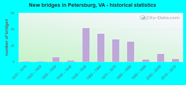
- New bridges - historical statistics
- 11910-1919
- 11920-1929
- 61930-1939
- 21940-1949
- 421950-1959
- 351960-1969
- 281970-1979
- 251980-1989
- 31990-1999
- 102000-2009
- 42010-2019
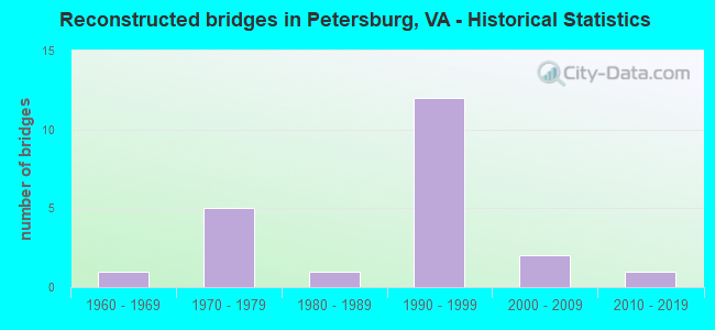
- Reconstructed bridges - Historical Statistics
- 11960-1969
- 51970-1979
- 11980-1989
- 121990-1999
- 22000-2009
- 12010-2019
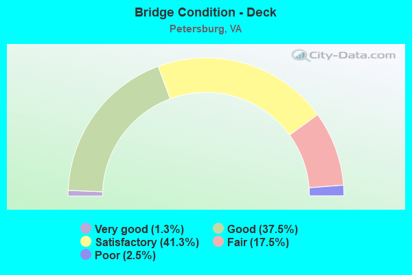
- Bridge Condition - Deck
- 1.3%Very good
- 37.5%Good
- 41.3%Satisfactory
- 17.5%Fair
- 2.5%Poor
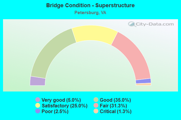
- Bridge Condition - Superstructure
- 5.0%Very good
- 35.0%Good
- 25.0%Satisfactory
- 31.3%Fair
- 2.5%Poor
- 1.3%Critical
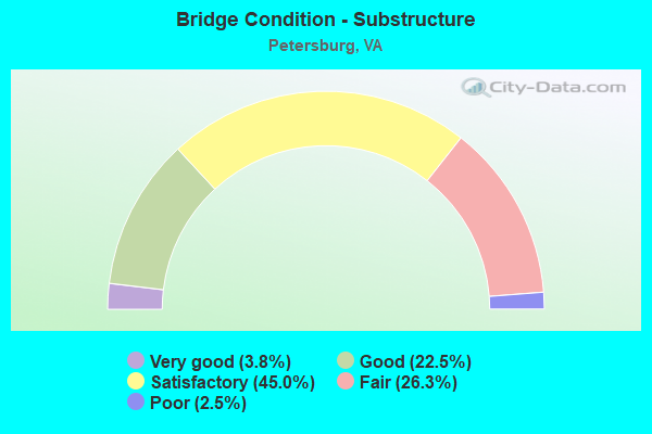
- Bridge Condition - Substructure
- 3.8%Very good
- 22.5%Good
- 45.0%Satisfactory
- 26.3%Fair
- 2.5%Poor
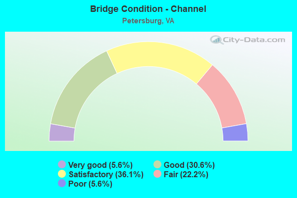
- Bridge Condition - Channel
- 5.6%Very good
- 30.6%Good
- 36.1%Satisfactory
- 22.2%Fair
- 5.6%Poor
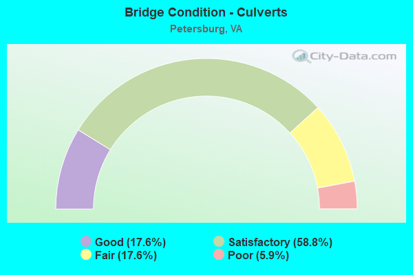
- Bridge Condition - Culverts
- 17.6%Good
- 58.8%Satisfactory
- 17.6%Fair
- 5.9%Poor
Find on map >> Show street view
Structure Number: 21118, Location: 1.47SCL Ptrbg 2.57 95 NBL (Lat: 37.198892, Lng: -77.420356), Route carried "on" structure: Interstate 85, Year Built: 1958, Year Reconstructed: 1997, Status: Open, Structure Length: 5.82m (19.09ft), Average Daily Traffic: 27,631 (year 2020), Truck Traffic: 13%, Average Future Daily Traffic: 38,683 (year 2040), Design Load: HS 20+Mod, Features Intersected: HALIFAX RD & CSX TRANSP.
Minimum Vertical Clearance: 30+ m (98+ ft), Kilometerpoint: 106.870, Lanes on structure: 2, Lanes under structure: 2, Base Highway Network: Yes, Owner: State Highway Agency, Approaching Roadway Width: 13.7m (44.9ft), Skew: 1 degrees, Material/Design: Steel, Design/Construction: Stringer/Multi-beam, Number Of Spans In Main Unit: 3, Length of Maximum Span: 33.2m (108.9ft), Curb-To-Curb Width: 13.7m (44.9ft), Out-to-Out Width: 14.6m (47.9ft)
Condition: Deck: Satisfactory, Superstructure: Good, Substructure: Fair, Operating Rating: 55.3 metric tons, Method Used To Determine Operating Rating: Load and Resistance Factor (LRFR), Inventory Rating: 42.6 metric tons, Method Used To Determine Inventory Rating: Load and Resistance Factor (LRFR), Structural Evaluation: Somewhat better than minimum adequacy, Deck Geometry: Superior to present desirable criteria, Underclear: Equal to present desirable criteria, Approach Roadway Alignment: Equal to present desirable criteria, Designated Inspection Frequency: Every 24 months, Inspection Date: November 2021, Deck Structure Type: Concrete Cast-file-Place, Wearing Surface/Protective System: Deck Protection: Epoxy Coated Reinforcing
Find on map >> Show street view
Structure Number: 2112, Location: 1.47SCL Ptrbrg 2.48 95 SB (Lat: 37.199019, Lng: -77.420342), Route carried "on" structure: Interstate 85, Year Built: 1958, Year Reconstructed: 1997, Status: Open, Structure Length: 5.82m (19.09ft), Average Daily Traffic: 26,480 (year 2020), Truck Traffic: 13%, Average Future Daily Traffic: 37,072 (year 2040), Design Load: HS 20+Mod, Features Intersected: HALIFAX RD & CSX TRANSP.
Minimum Vertical Clearance: 30+ m (98+ ft), Kilometerpoint: 106.870, Lanes on structure: 2, Lanes under structure: 2, Base Highway Network: Yes, Owner: State Highway Agency, Approaching Roadway Width: 13.7m (44.9ft), Skew: 1 degrees, Material/Design: Steel, Design/Construction: Stringer/Multi-beam, Number Of Spans In Main Unit: 3, Length of Maximum Span: 33.2m (108.9ft), Curb-To-Curb Width: 13.7m (44.9ft), Out-to-Out Width: 14.6m (47.9ft)
Condition: Deck: Satisfactory, Superstructure: Good, Substructure: Satisfactory, Operating Rating: 55.3 metric tons, Method Used To Determine Operating Rating: Load and Resistance Factor (LRFR), Inventory Rating: 42.6 metric tons, Method Used To Determine Inventory Rating: Load and Resistance Factor (LRFR), Structural Evaluation: Equal to present minimum criteria, Deck Geometry: Superior to present desirable criteria, Underclear: Meets minimum limits, Approach Roadway Alignment: Equal to present desirable criteria, Designated Inspection Frequency: Every 24 months, Inspection Date: November 2021, Deck Structure Type: Concrete Cast-file-Place, Wearing Surface/Protective System: Deck Protection: Epoxy Coated Reinforcing
Find on map >> Show street view
Structure Number: 21122, Location: 2.23 SCL Ptbg & 1.72 I-95 (Lat: 37.206283, Lng: -77.411014), Route carried "on" structure: Interstate 85, Year Built: 1958, Year Reconstructed: 1996, Status: Open, Structure Length: 3.69m (12.11ft), Average Daily Traffic: 27,631 (year 2020), Truck Traffic: 13%, Average Future Daily Traffic: 38,683 (year 2040), Design Load: HS 20+Mod, Features Intersected: BAYLORS LANE
Minimum Vertical Clearance: 30+ m (98+ ft), Kilometerpoint: 108.125, Lanes on structure: 2, Lanes under structure: 2, Base Highway Network: Yes, Owner: State Highway Agency, Approaching Roadway Width: 13.7m (44.9ft), Skew: 2 degrees, Material/Design: Steel, Design/Construction: Stringer/Multi-beam, Number Of Spans In Main Unit: 3, Length of Maximum Span: 17.4m (57.1ft), Curb-To-Curb Width: 13.6m (44.6ft), Out-to-Out Width: 14.6m (47.9ft)
Condition: Deck: Satisfactory, Superstructure: Good, Substructure: Good, Operating Rating: 89.8 metric tons, Method Used To Determine Operating Rating: Load and Resistance Factor (LRFR), Inventory Rating: 68.9 metric tons, Method Used To Determine Inventory Rating: Load and Resistance Factor (LRFR), Structural Evaluation: Better than present minimum criteria, Deck Geometry: Superior to present desirable criteria, Underclear: Meets minimum limits, Approach Roadway Alignment: Equal to present desirable criteria, Designated Inspection Frequency: Every 24 months, Inspection Date: January 2021, Deck Structure Type: Concrete Cast-file-Place, Wearing Surface/Protective System: Deck Protection: Epoxy Coated Reinforcing
Find on map >> Show street view
Structure Number: 21124, Location: 2.23 Ptbg & 1.72 To I-95 (Lat: 37.206417, Lng: -77.411056), Route carried "on" structure: Interstate 85, Year Built: 1958, Year Reconstructed: 1996, Status: Open, Structure Length: 3.69m (12.11ft), Average Daily Traffic: 26,480 (year 2020), Truck Traffic: 13%, Average Future Daily Traffic: 37,072 (year 2040), Design Load: HS 20+Mod, Features Intersected: BAYLORS LANE
Minimum Vertical Clearance: 30+ m (98+ ft), Kilometerpoint: 108.125, Lanes on structure: 2, Lanes under structure: 2, Base Highway Network: Yes, Owner: State Highway Agency, Approaching Roadway Width: 13.7m (44.9ft), Skew: 2 degrees, Material/Design: Steel, Design/Construction: Stringer/Multi-beam, Number Of Spans In Main Unit: 3, Length of Maximum Span: 17.4m (57.1ft), Curb-To-Curb Width: 13.6m (44.6ft), Out-to-Out Width: 14.6m (47.9ft)
Condition: Deck: Satisfactory, Superstructure: Good, Substructure: Good, Operating Rating: 89.8 metric tons, Method Used To Determine Operating Rating: Load and Resistance Factor (LRFR), Inventory Rating: 68.9 metric tons, Method Used To Determine Inventory Rating: Load and Resistance Factor (LRFR), Structural Evaluation: Better than present minimum criteria, Deck Geometry: Superior to present desirable criteria, Underclear: Better than present minimum criteria, Approach Roadway Alignment: Equal to present desirable criteria, Designated Inspection Frequency: Every 24 months, Inspection Date: January 2021, Deck Structure Type: Concrete Cast-file-Place, Wearing Surface/Protective System: Deck Protection: Epoxy Coated Reinforcing
Find on map >> Show street view
Structure Number: 21126, Location: 3.52SCL Peter .52 To 95NB (Lat: 37.217297, Lng: -77.391894), Route carried "on" structure: Interstate 85, Year Built: 1958, Year Reconstructed: 1997, Status: Open, Structure Length: 1.73m (5.68ft), Average Daily Traffic: 44,833 (year 2020), Truck Traffic: 14%, Average Future Daily Traffic: 56,056 (year 2040), Design Load: HS 20+Mod, Features Intersected: GRAHAM ROAD
Minimum Vertical Clearance: 30+ m (98+ ft), Kilometerpoint: 110.200, Lanes on structure: 4, Lanes under structure: 2, Base Highway Network: Yes, Owner: State Highway Agency, Approaching Roadway Width: 30.2m (99.1ft), Skew: 31 degrees, Material/Design: Steel, Design/Construction: Stringer/Multi-beam, Number Of Spans In Main Unit: 1, Length of Maximum Span: 16.2m (53.1ft), Curb-To-Curb Width: 29.1m (95.5ft), Out-to-Out Width: 30.8m (101.0ft)
Condition: Deck: Satisfactory, Superstructure: Good, Substructure: Fair, Operating Rating: 71.8 metric tons, Method Used To Determine Operating Rating: Load and Resistance Factor (LRFR), Inventory Rating: 55.3 metric tons, Method Used To Determine Inventory Rating: Load and Resistance Factor (LRFR), Structural Evaluation: Somewhat better than minimum adequacy, Deck Geometry: Superior to present desirable criteria, Underclear: Equal to present minimum criteria, Approach Roadway Alignment: Equal to present desirable criteria, Designated Inspection Frequency: Every 24 months, Inspection Date: November 2021, Deck Structure Type: Concrete Cast-file-Place, Wearing Surface/Protective System: Wearing Surface: Epoxy Overlay, Deck Protection: Epoxy Coated Reinforcing
Find on map >> Show street view
Structure Number: 2113, Location: 3.52 Fr Sq Lv & .45 To 95 (Lat: 37.217450, Lng: -77.392131), Route carried "on" structure: Interstate 85, Year Built: 1958, Year Reconstructed: 1997, Status: Open, Structure Length: 1.65m (5.41ft), Average Daily Traffic: 23,353 (year 2020), Truck Traffic: 14%, Average Future Daily Traffic: 32,694 (year 2040), Design Load: HS 20+Mod, Features Intersected: GRAHAM ROAD
Minimum Vertical Clearance: 30+ m (98+ ft), Kilometerpoint: 110.200, Lanes on structure: 2, Lanes under structure: 2, Base Highway Network: Yes, Owner: State Highway Agency, Approaching Roadway Width: 13.1m (43.0ft), Material/Design: Steel, Design/Construction: Stringer/Multi-beam, Number Of Spans In Main Unit: 1, Length of Maximum Span: 15.8m (51.8ft), Curb-To-Curb Width: 13.0m (42.7ft), Out-to-Out Width: 14.0m (45.9ft)
Condition: Deck: Satisfactory, Superstructure: Good, Substructure: Satisfactory, Operating Rating: 81.2 metric tons, Method Used To Determine Operating Rating: Load and Resistance Factor (LRFR), Inventory Rating: 62.7 metric tons, Method Used To Determine Inventory Rating: Load and Resistance Factor (LRFR), Structural Evaluation: Equal to present minimum criteria, Deck Geometry: Superior to present desirable criteria, Underclear: Equal to present minimum criteria, Approach Roadway Alignment: Equal to present desirable criteria, Designated Inspection Frequency: Every 24 months, Inspection Date: November 2021, Deck Structure Type: Concrete Cast-file-Place, Wearing Surface/Protective System: Deck Protection: Epoxy Coated Reinforcing
Find on map >> Show street view
Structure Number: 21133, Location: 2.73 Fr Pbg & 0.75 To 460 (Lat: 37.212167, Lng: -77.399889), Route carried "on" structure: Interstate 85, Year Built: 1959, Status: Open, Structure Length: 1.10m (3.61ft), Average Daily Traffic: 54,111 (year 2020), Truck Traffic: 13%, Average Future Daily Traffic: 64,968 (year 2040), Design Load: HS 20, Features Intersected: LIEUTENANT RUN
Minimum Vertical Clearance: 30+ m (98+ ft), Kilometerpoint: 109.090, Lanes on structure: 4, Base Highway Network: Yes, Owner: State Highway Agency, Approaching Roadway Width: 20.7m (67.9ft), Skew: 3 degrees, Material/Design: Concrete, Design/Construction: Culvert, Number Of Spans In Main Unit: 3, Length of Maximum Span: 3.5m (11.5ft)
Condition: Channel: Fair, Culverts: Satisfactory, Operating Rating: 54.4 metric tons, Method Used To Determine Operating Rating: Field evaluation and documented engineering judgment, Inventory Rating: 32.7 metric tons, Method Used To Determine Inventory Rating: Field evaluation and documented engineering judgment, Structural Evaluation: Equal to present minimum criteria, Waterway Adequacy: Equal to present minimum criteria, Approach Roadway Alignment: Equal to present desirable criteria, Designated Inspection Frequency: Every 24 months, Inspection Date: March 2021
Find on map >> Show street view
Structure Number: 21135, Location: .04 Ptsbrg CL & 3.98 I-95 (Lat: 37.199697, Lng: -77.444206), Route carried "on" structure: Interstate 85, Year Built: 1959, Status: Open, Structure Length: 0.70m (2.30ft), Average Daily Traffic: 47,807 (year 2020), Truck Traffic: 13%, Average Future Daily Traffic: 65,604 (year 2040), Design Load: HS 20, Features Intersected: ROHOIC CREEK
Minimum Vertical Clearance: 30+ m (98+ ft), Kilometerpoint: 104.601, Lanes on structure: 4, Base Highway Network: Yes, Owner: State Highway Agency, Approaching Roadway Width: 20.7m (67.9ft), Skew: 1 degrees, Material/Design: Concrete, Design/Construction: Culvert, Number Of Spans In Main Unit: 2, Length of Maximum Span: 3.0m (9.8ft)
Condition: Channel: Satisfactory, Culverts: Fair, Operating Rating: 89.8 metric tons, Method Used To Determine Operating Rating: Field evaluation and documented engineering judgment, Inventory Rating: 89.8 metric tons, Method Used To Determine Inventory Rating: Field evaluation and documented engineering judgment, Structural Evaluation: Somewhat better than minimum adequacy, Waterway Adequacy: Equal to present minimum criteria, Approach Roadway Alignment: Equal to present desirable criteria, Designated Inspection Frequency: Every 24 months, Inspection Date: October 2020
Find on map >> Show street view
Structure Number: 21136, Location: .03 Fr SQL & .04 To 85SB (Lat: 37.199117, Lng: -77.427717), Route carried "on" structure: Ramp Interstate 85, Year Built: 1988, Status: Open, Structure Length: 0.88m (2.89ft), Average Daily Traffic: 1,122 (year 2020), Average Future Daily Traffic: 1,368 (year 2040), Design Load: H 20, Features Intersected: STREAM
Minimum Vertical Clearance: 30+ m (98+ ft), Kilometerpoint: 0.161, Lanes on structure: 1, Base Highway Network: Yes, Owner: State Highway Agency, Approaching Roadway Width: 8.5m (27.9ft), Material/Design: Concrete, Design/Construction: Culvert, Number Of Spans In Main Unit: 4, Length of Maximum Span: 1.5m (4.9ft)
Condition: Channel: Satisfactory, Culverts: Satisfactory, Operating Rating: 89.8 metric tons, Method Used To Determine Operating Rating: Field evaluation and documented engineering judgment, Inventory Rating: 89.8 metric tons, Method Used To Determine Inventory Rating: Field evaluation and documented engineering judgment, Structural Evaluation: Equal to present minimum criteria, Waterway Adequacy: Equal to present minimum criteria, Approach Roadway Alignment: Equal to present desirable criteria, Designated Inspection Frequency: Every 24 months, Inspection Date: November 2020
Find on map >> Show street view
Structure Number: 21137, Location: 2.06 mi from Rte 632 Ramp (Lat: 37.216017, Lng: -77.383789), Route carried "on" structure: Interstate 95, Year Built: 1962, Year Reconstructed: 1981, Status: Open, Structure Length: 4.96m (16.27ft), Average Daily Traffic: 20,214 (year 2020), Truck Traffic: 17%, Average Future Daily Traffic: 28,300 (year 2040), Design Load: HS 20+Mod, Features Intersected: RTES 301 & EB 460
Minimum Vertical Clearance: 30+ m (98+ ft), Kilometerpoint: 82.236, Lanes on structure: 4, Lanes under structure: 5, Base Highway Network: Yes, Owner: State Highway Agency, Approaching Roadway Width: 21.3m (69.9ft), Skew: 31 degrees, Material/Design: Steel, Design/Construction: Stringer/Multi-beam, Number Of Spans In Main Unit: 3, Length of Maximum Span: 24.4m (80.1ft), Curb-To-Curb Width: 20.8m (68.2ft), Out-to-Out Width: 22.4m (73.5ft)
Condition: Deck: Poor, Superstructure: Fair, Substructure: Fair, Operating Rating: 46.1 metric tons, Method Used To Determine Operating Rating: Load and Resistance Factor (LRFR), Inventory Rating: 35.6 metric tons, Method Used To Determine Inventory Rating: Load and Resistance Factor (LRFR), Structural Evaluation: Somewhat better than minimum adequacy, Deck Geometry: Equal to present minimum criteria, Underclear: Meets minimum limits, Approach Roadway Alignment: Equal to present desirable criteria, Length Of Structure Improvement: 4.97m (16.31ft), Designated Inspection Frequency: Every 12 months, Inspection Date: September 2021, Bridge Improvement Cost: $90,000, Roadway Improvement Cost: $15,000, Total Project Cost: $110,000, Deck Structure Type: Concrete Cast-file-Place, Wearing Surface/Protective System: Wearing Surface: Bituminous, Membrane: Preformed Fabric
Find on map >> Show street view
Structure Number: 21139, Location: 2.06 mi from Rte 632 Ramp (Lat: 37.216139, Lng: -77.383747), Route carried "on" structure: Interstate 95, Year Built: 1962, Status: Open, Structure Length: 4.95m (16.24ft), Average Daily Traffic: 20,384 (year 2020), Truck Traffic: 12%, Average Future Daily Traffic: 22,422 (year 2040), Design Load: HS 20+Mod, Features Intersected: RTES 301 & EB 460
Minimum Vertical Clearance: 30+ m (98+ ft), Kilometerpoint: 82.236, Lanes on structure: 4, Lanes under structure: 4, Base Highway Network: Yes, Owner: State Highway Agency, Approaching Roadway Width: 21.3m (69.9ft), Skew: 31 degrees, Material/Design: Steel, Design/Construction: Stringer/Multi-beam, Number Of Spans In Main Unit: 3, Length of Maximum Span: 24.3m (79.7ft), Curb-To-Curb Width: 20.8m (68.2ft), Out-to-Out Width: 22.4m (73.5ft)
Condition: Deck: Fair, Superstructure: Fair, Substructure: Fair, Operating Rating: 47.4 metric tons, Method Used To Determine Operating Rating: Load and Resistance Factor (LRFR), Inventory Rating: 36.6 metric tons, Method Used To Determine Inventory Rating: Load and Resistance Factor (LRFR), Structural Evaluation: Somewhat better than minimum adequacy, Deck Geometry: Equal to present minimum criteria, Underclear: Meets minimum limits, Approach Roadway Alignment: Equal to present desirable criteria, Length Of Structure Improvement: 4.94m (16.21ft), Designated Inspection Frequency: Every 24 months, Inspection Date: September 2020, Bridge Improvement Cost: $90,000, Roadway Improvement Cost: $15,000, Total Project Cost: $110,000, Deck Structure Type: Concrete Cast-file-Place, Wearing Surface/Protective System: Wearing Surface: Bituminous, Membrane: Preformed Fabric
Find on map >> Show street view
Structure Number: 21141, Location: 3.95 FR 295 & .74 TO 460 (Lat: 37.213111, Lng: -77.377000), Route carried "on" structure: Interstate 95, Year Built: 1962, Status: Open, Structure Length: 1.56m (5.12ft), Average Daily Traffic: 24,000 (year 2020), Truck Traffic: 17%, Average Future Daily Traffic: 28,300 (year 2040), Design Load: HS 20+Mod, Features Intersected: EBL RTE 460
Minimum Vertical Clearance: 30+ m (98+ ft), Kilometerpoint: 80.547, Lanes on structure: 2, Lanes under structure: 2, Base Highway Network: Yes, Owner: State Highway Agency, Approaching Roadway Width: 12.8m (42.0ft), Skew: 2 degrees, Material/Design: Steel, Design/Construction: Stringer/Multi-beam, Number Of Spans In Main Unit: 1, Length of Maximum Span: 14.4m (47.2ft), Curb-To-Curb Width: 12.8m (42.0ft), Out-to-Out Width: 13.4m (44.0ft)
Condition: Deck: Fair, Superstructure: Fair, Substructure: Fair, Operating Rating: 55.3 metric tons, Method Used To Determine Operating Rating: Load and Resistance Factor (LRFR), Inventory Rating: 42.6 metric tons, Method Used To Determine Inventory Rating: Load and Resistance Factor (LRFR), Structural Evaluation: Somewhat better than minimum adequacy, Deck Geometry: Equal to present desirable criteria, Underclear: Meets minimum limits, Approach Roadway Alignment: Equal to present desirable criteria, Designated Inspection Frequency: Every 24 months, Inspection Date: January 2022, Deck Structure Type: Concrete Cast-file-Place, Wearing Surface/Protective System: Wearing Surface: Bituminous
Find on map >> Show street view
Structure Number: 21143, Location: 4.07 FR I295 &.40 TO 460 (Lat: 37.213236, Lng: -77.376833), Route carried "on" structure: Interstate 95, Year Built: 1962, Status: Open, Structure Length: 1.56m (5.12ft), Average Daily Traffic: 23,000 (year 2020), Truck Traffic: 19%, Average Future Daily Traffic: 22,422 (year 2040), Design Load: HS 20+Mod, Features Intersected: EBL RTE 460
Minimum Vertical Clearance: 30+ m (98+ ft), Kilometerpoint: 81.415, Lanes on structure: 3, Lanes under structure: 2, Base Highway Network: Yes, Owner: State Highway Agency, Approaching Roadway Width: 19.8m (65.0ft), Skew: 32 degrees, Material/Design: Steel, Design/Construction: Stringer/Multi-beam, Number Of Spans In Main Unit: 1, Length of Maximum Span: 14.4m (47.2ft), Curb-To-Curb Width: 19.4m (63.6ft), Out-to-Out Width: 20.7m (67.9ft)
Condition: Deck: Fair, Superstructure: Satisfactory, Substructure: Fair, Operating Rating: 51.7 metric tons, Method Used To Determine Operating Rating: Load and Resistance Factor (LRFR), Inventory Rating: 39.9 metric tons, Method Used To Determine Inventory Rating: Load and Resistance Factor (LRFR), Structural Evaluation: Somewhat better than minimum adequacy, Deck Geometry: Superior to present desirable criteria, Underclear: Meets minimum limits, Approach Roadway Alignment: Equal to present desirable criteria, Designated Inspection Frequency: Every 24 months, Inspection Date: January 2022, Deck Structure Type: Concrete Cast-file-Place
Find on map >> Show street view
Structure Number: 21145, Location: .73 FR 85N & .35 CH CL (Lat: 37.234056, Lng: -77.395578), Route carried "on" structure: Interstate 95, Year Built: 1958, Year Reconstructed: 1976, Status: Open, Structure Length: 24.99m (81.99ft), Average Daily Traffic: 96,667 (year 2020), Truck Traffic: 1%, Average Future Daily Traffic: 135,334 (year 2040), Design Load: HS 20, Features Intersected: NS; B BROOK ST; LT RUN
Minimum Vertical Clearance: 30+ m (98+ ft), Kilometerpoint: 84.730, Lanes on structure: 7, Lanes under structure: 2, Base Highway Network: Yes, Owner: State Highway Agency, Approaching Roadway Width: 31.2m (102.4ft), Skew: 33 degrees, Navigation Control: Yes ( Vertical Clearance: 12.1m (39.7ft), Horizontal Clearance: 30.4m (99.7ft)), Material/Design: Steel, Design/Construction: Girder and Floorbeam System, Number Of Spans In Main Unit: 7, Length of Maximum Span: 46.0m (150.9ft), Curb-To-Curb Width: 31.2m (102.4ft), Out-to-Out Width: 33.2m (108.9ft)
Condition: Deck: Satisfactory, Superstructure: Fair, Substructure: Fair, Channel: Good, Operating Rating: 55.0 metric tons, Method Used To Determine Operating Rating: Load Factor (LF), Inventory Rating: 32.8 metric tons, Method Used To Determine Inventory Rating: Load Factor (LF), Structural Evaluation: Somewhat better than minimum adequacy, Deck Geometry: Equal to present minimum criteria, Underclear: Somewhat better than minimum adequacy, Waterway Adequacy: Equal to present desirable criteria, Approach Roadway Alignment: Equal to present desirable criteria, Length Of Structure Improvement: 24.96m (81.89ft), Designated Inspection Frequency: Every 24 months, Critical Feature Inspection Frequency: Every 12 months, Inspection Date: May 2021, Critical Feature Inspection Date: May 2021, Bridge Improvement Cost: $160,000, Roadway Improvement Cost: $1,000, Total Project Cost: $193,000, Deck Structure Type: Concrete Cast-file-Place, Wearing Surface/Protective System: Wearing Surface: Latex Concrete
Find on map >> Show street view
Structure Number: 21149, Location: 1.0 FR WGNR & 1.64 TO 460 (Lat: 37.204503, Lng: -77.365194), Route carried "on" structure: Interstate 95, Year Built: 1962, Status: Open, Structure Length: 6.00m (19.69ft), Average Daily Traffic: 23,084 (year 2020), Truck Traffic: 13%, Average Future Daily Traffic: 32,318 (year 2040), Design Load: HS 20+Mod, Features Intersected: N&S RAILWAY
Minimum Vertical Clearance: 30+ m (98+ ft), Kilometerpoint: 80.112, Lanes on structure: 2, Base Highway Network: Yes, Owner: State Highway Agency, Approaching Roadway Width: 11.0m (36.1ft), Material/Design: Steel, Design/Construction: Stringer/Multi-beam, Number Of Spans In Main Unit: 3, Length of Maximum Span: 26.2m (86.0ft), Curb-To-Curb Width: 12.8m (42.0ft), Out-to-Out Width: 13.4m (44.0ft)
Condition: Deck: Fair, Superstructure: Fair, Substructure: Fair, Operating Rating: 53.6 metric tons, Method Used To Determine Operating Rating: Load and Resistance Factor (LRFR), Inventory Rating: 41.4 metric tons, Method Used To Determine Inventory Rating: Load and Resistance Factor (LRFR), Structural Evaluation: Somewhat better than minimum adequacy, Deck Geometry: Equal to present desirable criteria, Underclear: Better than present minimum criteria, Approach Roadway Alignment: Equal to present desirable criteria, Designated Inspection Frequency: Every 24 months, Inspection Date: August 2020, Deck Structure Type: Concrete Cast-file-Place, Wearing Surface/Protective System: Wearing Surface: Bituminous, Membrane: Preformed Fabric
Find on map >> Show street view
Structure Number: 21151, Location: .14 85 N & .23 36/460 E (Lat: 37.224775, Lng: -77.393061), Route carried "on" structure: Interstate 95, Year Built: 1978, Status: Open, Structure Length: 4.67m (15.32ft), Average Daily Traffic: 44,649 (year 2020), Truck Traffic: 19%, Average Future Daily Traffic: 62,509 (year 2040), Design Load: HS 20+Mod, Features Intersected: MINGEA STREET
Minimum Vertical Clearance: 30+ m (98+ ft), Kilometerpoint: 83.555, Lanes on structure: 4, Lanes under structure: 2, Base Highway Network: Yes, Owner: State Highway Agency, Approaching Roadway Width: 21.0m (68.9ft), Skew: 1 degrees, Material/Design: Steel continuous, Design/Construction: Stringer/Multi-beam, Number Of Spans In Main Unit: 3, Length of Maximum Span: 19.8m (65.0ft), Curb-To-Curb Width: 22.1m (72.5ft), Out-to-Out Width: 23.3m (76.4ft)
Condition: Deck: Satisfactory, Superstructure: Fair, Substructure: Satisfactory, Operating Rating: 74.4 metric tons, Method Used To Determine Operating Rating: Load and Resistance Factor (LRFR), Inventory Rating: 57.2 metric tons, Method Used To Determine Inventory Rating: Load and Resistance Factor (LRFR), Structural Evaluation: Somewhat better than minimum adequacy, Deck Geometry: Equal to present desirable criteria, Underclear: Meets minimum limits, Approach Roadway Alignment: Equal to present desirable criteria, Designated Inspection Frequency: Every 24 months, Inspection Date: June 2021, Deck Structure Type: Concrete Cast-file-Place, Wearing Surface/Protective System: Wearing Surface: Bituminous, Membrane: Preformed Fabric
Find on map >> Show street view
Structure Number: 21153, Location: 0.46 Fr 85S & .09 To 460W (Lat: 37.227639, Lng: -77.395297), Route carried "on" structure: Interstate 95, Year Built: 1958, Year Reconstructed: 1978, Status: Open, Structure Length: 3.44m (11.29ft), Average Daily Traffic: 52,011 (year 2020), Truck Traffic: 9%, Average Future Daily Traffic: 72,815 (year 2040), Design Load: HS 20+Mod, Features Intersected: EB RT 460 BUS (36) WYTHE
Minimum Vertical Clearance: 30+ m (98+ ft), Kilometerpoint: 84.038, Lanes on structure: 3, Lanes under structure: 3, Base Highway Network: Yes, Owner: State Highway Agency, Approaching Roadway Width: 15.8m (51.8ft), Material/Design: Steel, Design/Construction: Stringer/Multi-beam, Number Of Spans In Main Unit: 1, Number Of Approach Spans: 2, Length of Maximum Span: 20.7m (67.9ft), Curb-To-Curb Width: 15.8m (51.8ft), Out-to-Out Width: 17.1m (56.1ft)
Condition: Deck: Satisfactory, Superstructure: Fair, Substructure: Satisfactory, Operating Rating: 74.8 metric tons, Method Used To Determine Operating Rating: Load and Resistance Factor (LRFR), Inventory Rating: 57.7 metric tons, Method Used To Determine Inventory Rating: Load and Resistance Factor (LRFR), Structural Evaluation: Somewhat better than minimum adequacy, Deck Geometry: Somewhat better than minimum adequacy, Underclear: Better than present minimum criteria, Approach Roadway Alignment: Equal to present desirable criteria, Designated Inspection Frequency: Every 24 months, Inspection Date: June 2021, Deck Structure Type: Concrete Cast-file-Place, Wearing Surface/Protective System: Wearing Surface: Bituminous, Membrane: Preformed Fabric
Find on map >> Show street view
Structure Number: 21155, Location: 0.23 Fr 460WB &0.45SCL CH (Lat: 37.232197, Lng: -77.395681), Route carried "on" structure: Interstate 95, Year Built: 1958, Year Reconstructed: 1978, Status: Open, Structure Length: 3.45m (11.32ft), Average Daily Traffic: 96,667 (year 2020), Truck Traffic: 8%, Average Future Daily Traffic: 135,334 (year 2040), Design Load: HS 20, Features Intersected: ROUTE 36 (BANK ST)
Minimum Vertical Clearance: 30+ m (98+ ft), Kilometerpoint: 84.569, Lanes on structure: 8, Lanes under structure: 2, Base Highway Network: Yes, Owner: State Highway Agency, Approaching Roadway Width: 48.9m (160.4ft), Skew: 30 degrees, Material/Design: Steel, Design/Construction: Stringer/Multi-beam, Number Of Spans In Main Unit: 3, Length of Maximum Span: 17.5m (57.4ft), Curb-To-Curb Width: 51.5m (169.0ft), Out-to-Out Width: 52.7m (172.9ft)
Condition: Deck: Satisfactory, Superstructure: Fair, Substructure: Fair, Operating Rating: 49.9 metric tons, Method Used To Determine Operating Rating: Load and Resistance Factor (LRFR), Inventory Rating: 38.1 metric tons, Method Used To Determine Inventory Rating: Load and Resistance Factor (LRFR), Structural Evaluation: Somewhat better than minimum adequacy, Deck Geometry: Superior to present desirable criteria, Underclear: Equal to present minimum criteria, Approach Roadway Alignment: Equal to present desirable criteria, Length Of Structure Improvement: 3.44m (11.29ft), Designated Inspection Frequency: Every 24 months, Other Special Inspection Frequency: Every 24 months, Inspection Date: December 2021, Other Special Inspection Date: December 2020, Bridge Improvement Cost: $2,352,000, Roadway Improvement Cost: $120,000, Total Project Cost: $2,991,000, Deck Structure Type: Concrete Cast-file-Place, Wearing Surface/Protective System: Deck Protection: Epoxy Coated Reinforcing
Find on map >> Show street view
Structure Number: 21157, Location: .39 Fr 301 & .35 To NBL85 (Lat: 37.218933, Lng: -77.389800), Route carried "on" structure: Interstate 95, Year Built: 1978, Status: Open, Structure Length: 5.91m (19.39ft), Average Daily Traffic: 50,177 (year 2020), Truck Traffic: 14%, Average Future Daily Traffic: 70,248 (year 2040), Design Load: HS 20+Mod, Features Intersected: RTE I-85 NBL & RAMP D
Minimum Vertical Clearance: 30+ m (98+ ft), Kilometerpoint: 82.864, Lanes on structure: 6, Lanes under structure: 3, Base Highway Network: Yes, Owner: State Highway Agency, Approaching Roadway Width: 35.7m (117.1ft), Skew: 39 degrees, Material/Design: Steel, Design/Construction: Stringer/Multi-beam, Number Of Spans In Main Unit: 2, Length of Maximum Span: 31.1m (102.0ft), Curb-To-Curb Width: 34.5m (113.2ft), Out-to-Out Width: 36.9m (121.1ft)
Condition: Deck: Fair, Superstructure: Fair, Substructure: Fair, Operating Rating: 66.0 metric tons, Method Used To Determine Operating Rating: Load and Resistance Factor (LRFR), Inventory Rating: 51.0 metric tons, Method Used To Determine Inventory Rating: Load and Resistance Factor (LRFR), Structural Evaluation: Somewhat better than minimum adequacy, Deck Geometry: Superior to present desirable criteria, Underclear: High priority of corrective action, Approach Roadway Alignment: Equal to present desirable criteria, Length Of Structure Improvement: 5.91m (19.39ft), Designated Inspection Frequency: Every 24 months, Inspection Date: August 2021, Bridge Improvement Cost: $582,000, Roadway Improvement Cost: $210,000, Total Project Cost: $950,000, Deck Structure Type: Concrete Cast-file-Place, Wearing Surface/Protective System: Wearing Surface: Bituminous, Membrane: Preformed Fabric
Find on map >> Show street view
Structure Number: 21161, Location: 0.87 Fr 95N & 0.23 To 36E (Lat: 37.225003, Lng: -77.392786), Route carried "on" structure: Ramp Interstate 95, Year Built: 1978, Status: Open, Structure Length: 4.24m (13.91ft), Average Daily Traffic: 5,493 (year 2020), Average Future Daily Traffic: 6,377 (year 2040), Design Load: HS 20+Mod, Features Intersected: MINGEA STREET
Minimum Vertical Clearance: 30+ m (98+ ft), Kilometerpoint: 0.193, Lanes on structure: 2, Lanes under structure: 2, Base Highway Network: Yes, Owner: State Highway Agency, Approaching Roadway Width: 13.7m (44.9ft), Skew: 1 degrees, Material/Design: Steel continuous, Design/Construction: Stringer/Multi-beam, Number Of Spans In Main Unit: 3, Length of Maximum Span: 18.7m (61.4ft), Curb-To-Curb Width: 12.6m (41.3ft), Out-to-Out Width: 13.8m (45.3ft)
Condition: Deck: Satisfactory, Superstructure: Fair, Substructure: Satisfactory, Operating Rating: 72.6 metric tons, Method Used To Determine Operating Rating: Load and Resistance Factor (LRFR), Inventory Rating: 55.3 metric tons, Method Used To Determine Inventory Rating: Load and Resistance Factor (LRFR), Structural Evaluation: Somewhat better than minimum adequacy, Deck Geometry: Superior to present desirable criteria, Approach Roadway Alignment: Equal to present desirable criteria, Designated Inspection Frequency: Every 24 months, Inspection Date: June 2021, Deck Structure Type: Concrete Cast-file-Place, Wearing Surface/Protective System: Wearing Surface: Bituminous, Membrane: Preformed Fabric
Find on map >> Show street view
Structure Number: 21163, Location: .23 fr 36E & .04 to 95S (Lat: 37.224414, Lng: -77.393442), Route carried "on" structure: Ramp Interstate 95, Year Built: 1978, Status: Open, Structure Length: 4.53m (14.86ft), Average Daily Traffic: 3,480 (year 2020), Average Future Daily Traffic: 4,873 (year 2040), Design Load: HS 20+Mod, Features Intersected: MINGEA STREET
Minimum Vertical Clearance: 30+ m (98+ ft), Kilometerpoint: 0.193, Lanes on structure: 2, Lanes under structure: 2, Base Highway Network: Yes, Owner: State Highway Agency, Approaching Roadway Width: 11.0m (36.1ft), Skew: 2 degrees, Material/Design: Steel continuous, Design/Construction: Stringer/Multi-beam, Number Of Spans In Main Unit: 3, Length of Maximum Span: 19.5m (64.0ft), Curb-To-Curb Width: 11.0m (36.1ft), Out-to-Out Width: 12.2m (40.0ft)
Condition: Deck: Satisfactory, Superstructure: Fair, Substructure: Satisfactory, Operating Rating: 70.8 metric tons, Method Used To Determine Operating Rating: Load and Resistance Factor (LRFR), Inventory Rating: 54.4 metric tons, Method Used To Determine Inventory Rating: Load and Resistance Factor (LRFR), Structural Evaluation: Somewhat better than minimum adequacy, Deck Geometry: Better than present minimum criteria, Underclear: Somewhat better than minimum adequacy, Approach Roadway Alignment: Equal to present desirable criteria, Designated Inspection Frequency: Every 24 months, Inspection Date: June 2021, Deck Structure Type: Concrete Cast-file-Place, Wearing Surface/Protective System: Wearing Surface: Bituminous, Membrane: Preformed Fabric
Find on map >> Show street view
Structure Number: 21165, Location: .20 FR 85N &.78 TO COLHTS (Lat: 37.227678, Lng: -77.395075), Route carried "on" structure: Interstate 95, Year Built: 1958, Year Reconstructed: 1978, Status: Open, Structure Length: 3.44m (11.29ft), Average Daily Traffic: 44,649 (year 2020), Truck Traffic: 9%, Average Future Daily Traffic: 62,509 (year 2040), Design Load: HS 20+Mod, Features Intersected: EB RT 460 BUS (36) WYTHE
Minimum Vertical Clearance: 30+ m (98+ ft), Kilometerpoint: 84.038, Lanes on structure: 3, Lanes under structure: 3, Base Highway Network: Yes, Owner: State Highway Agency, Approaching Roadway Width: 15.8m (51.8ft), Material/Design: Steel, Design/Construction: Stringer/Multi-beam, Number Of Spans In Main Unit: 1, Number Of Approach Spans: 2, Length of Maximum Span: 21.3m (69.9ft), Curb-To-Curb Width: 15.8m (51.8ft), Out-to-Out Width: 17.1m (56.1ft)
Condition: Deck: Satisfactory, Superstructure: Fair, Substructure: Satisfactory, Operating Rating: 70.9 metric tons, Method Used To Determine Operating Rating: Load and Resistance Factor (LRFR), Inventory Rating: 54.7 metric tons, Method Used To Determine Inventory Rating: Load and Resistance Factor (LRFR), Structural Evaluation: Somewhat better than minimum adequacy, Deck Geometry: Somewhat better than minimum adequacy, Underclear: Better than present minimum criteria, Approach Roadway Alignment: Equal to present desirable criteria, Designated Inspection Frequency: Every 24 months, Inspection Date: June 2021, Deck Structure Type: Concrete Cast-file-Place, Wearing Surface/Protective System: Wearing Surface: Bituminous, Membrane: Preformed Fabric
Find on map >> Show street view
Structure Number: 21167, Location: .05 TO 460W & .65 FR 85S (Lat: 37.227553, Lng: -77.395528), Route carried "on" structure: Ramp Interstate 95, Year Built: 1978, Status: Open, Structure Length: 14.02m (46.00ft), Average Daily Traffic: 2,088 (year 2020), Average Future Daily Traffic: 2,923 (year 2040), Design Load: HS 20+Mod, Features Intersected: WYTHE STREET 460(36)
Minimum Vertical Clearance: 30+ m (98+ ft), Kilometerpoint: 0.080, Lanes on structure: 1, Lanes under structure: 3, Base Highway Network: Yes, Owner: State Highway Agency, Approaching Roadway Width: 8.5m (27.9ft), Material/Design: Steel continuous, Design/Construction: Stringer/Multi-beam, Number Of Spans In Main Unit: 4, Length of Maximum Span: 38.4m (126.0ft), Curb-To-Curb Width: 8.5m (27.9ft), Out-to-Out Width: 9.8m (32.2ft)
Condition: Deck: Satisfactory, Superstructure: Fair, Substructure: Satisfactory, Operating Rating: 47.2 metric tons, Method Used To Determine Operating Rating: Load and Resistance Factor (LRFR), Inventory Rating: 36.3 metric tons, Method Used To Determine Inventory Rating: Load and Resistance Factor (LRFR), Structural Evaluation: Somewhat better than minimum adequacy, Deck Geometry: Superior to present desirable criteria, Underclear: Superior to present desirable criteria, Approach Roadway Alignment: Equal to present desirable criteria, Designated Inspection Frequency: Every 24 months, Inspection Date: June 2021, Deck Structure Type: Concrete Cast-file-Place, Wearing Surface/Protective System: Wearing Surface: Bituminous, Membrane: Preformed Fabric
Find on map >> Show street view
Structure Number: 21169, Location: 0.05 FR 460W & .30 TO 85N (Lat: 37.227744, Lng: -77.394617), Route carried "on" structure: Ramp Interstate 95, Year Built: 1978, Status: Open, Structure Length: 4.59m (15.06ft), Average Daily Traffic: 2,282 (year 2020), Average Future Daily Traffic: 2,510 (year 2040), Design Load: HS 20+Mod, Features Intersected: EB RT 460 BUS (36) WYTHE
Minimum Vertical Clearance: 30+ m (98+ ft), Kilometerpoint: 0.579, Lanes on structure: 1, Lanes under structure: 2, Base Highway Network: Yes, Owner: State Highway Agency, Approaching Roadway Width: 8.5m (27.9ft), Skew: 2 degrees, Material/Design: Steel, Design/Construction: Stringer/Multi-beam, Number Of Spans In Main Unit: 3, Length of Maximum Span: 22.6m (74.1ft), Curb-To-Curb Width: 8.5m (27.9ft), Out-to-Out Width: 9.8m (32.2ft)
Condition: Deck: Satisfactory, Superstructure: Fair, Substructure: Satisfactory, Operating Rating: 71.7 metric tons, Method Used To Determine Operating Rating: Load and Resistance Factor (LRFR), Inventory Rating: 55.3 metric tons, Method Used To Determine Inventory Rating: Load and Resistance Factor (LRFR), Structural Evaluation: Somewhat better than minimum adequacy, Deck Geometry: Superior to present desirable criteria, Underclear: Equal to present minimum criteria, Approach Roadway Alignment: Equal to present desirable criteria, Designated Inspection Frequency: Every 24 months, Inspection Date: June 2021, Deck Structure Type: Concrete Cast-file-Place, Wearing Surface/Protective System: Wearing Surface: Bituminous, Membrane: Preformed Fabric
Find on map >> Show street view
Structure Number: 21171, Location: .06 FR 85S & .23 TO 460E (Lat: 37.224622, Lng: -77.393183), Route carried "on" structure: Interstate 95, Year Built: 1978, Status: Open, Structure Length: 5.31m (17.42ft), Average Daily Traffic: 52,011 (year 2020), Truck Traffic: 1%, Average Future Daily Traffic: 72,815 (year 2040), Design Load: HS 20+Mod, Features Intersected: MINGEA STREET
Minimum Vertical Clearance: 30+ m (98+ ft), Kilometerpoint: 83.555, Lanes on structure: 3, Lanes under structure: 2, Base Highway Network: Yes, Owner: State Highway Agency, Approaching Roadway Width: 16.8m (55.1ft), Skew: 2 degrees, Material/Design: Steel continuous, Design/Construction: Stringer/Multi-beam, Number Of Spans In Main Unit: 3, Length of Maximum Span: 20.0m (65.6ft), Curb-To-Curb Width: 16.7m (54.8ft), Out-to-Out Width: 17.9m (58.7ft)
Condition: Deck: Satisfactory, Superstructure: Fair, Substructure: Satisfactory, Operating Rating: 58.1 metric tons, Method Used To Determine Operating Rating: Load and Resistance Factor (LRFR), Inventory Rating: 44.5 metric tons, Method Used To Determine Inventory Rating: Load and Resistance Factor (LRFR), Structural Evaluation: Somewhat better than minimum adequacy, Deck Geometry: Equal to present minimum criteria, Underclear: Somewhat better than minimum adequacy, Approach Roadway Alignment: Equal to present desirable criteria, Designated Inspection Frequency: Every 24 months, Inspection Date: June 2021, Deck Structure Type: Concrete Cast-file-Place, Wearing Surface/Protective System: Wearing Surface: Bituminous, Membrane: Preformed Fabric
Find on map >> Show street view
Structure Number: 21173, Location: .13 FR 460 & .07 TO 95 NB (Lat: 37.230897, Lng: -77.394986), Route carried "on" structure: Ramp Interstate 95, Year Built: 1978, Status: Open, Structure Length: 1.71m (5.61ft), Average Daily Traffic: 3,908 (year 2020), Average Future Daily Traffic: 5,471 (year 2040), Design Load: HS 20+Mod, Features Intersected: I-95 RAMP S
Minimum Vertical Clearance: 30+ m (98+ ft), Kilometerpoint: 0.000, Lanes on structure: 2, Lanes under structure: 1, Base Highway Network: Yes, Owner: State Highway Agency, Approaching Roadway Width: 12.2m (40.0ft), Skew: 5 degrees, Material/Design: Steel, Design/Construction: Stringer/Multi-beam, Number Of Spans In Main Unit: 1, Length of Maximum Span: 15.5m (50.9ft), Curb-To-Curb Width: 12.2m (40.0ft), Out-to-Out Width: 13.4m (44.0ft)
Condition: Deck: Satisfactory, Superstructure: Satisfactory, Substructure: Fair, Operating Rating: 84.4 metric tons, Method Used To Determine Operating Rating: Load and Resistance Factor (LRFR), Inventory Rating: 65.1 metric tons, Method Used To Determine Inventory Rating: Load and Resistance Factor (LRFR), Structural Evaluation: Somewhat better than minimum adequacy, Deck Geometry: Superior to present desirable criteria, Underclear: Meets minimum limits, Approach Roadway Alignment: Equal to present desirable criteria, Designated Inspection Frequency: Every 24 months, Inspection Date: August 2020, Deck Structure Type: Concrete Cast-file-Place
Find on map >> Show street view
Structure Number: 21175, Location: 0.10 Fr 95S & 0.15 To 36E (Lat: 37.220378, Lng: -77.391814), Route carried "on" structure: Ramp Interstate 95, Year Built: 1978, Status: Open, Structure Length: 11.80m (38.71ft), Average Daily Traffic: 2,092 (year 2020), Average Future Daily Traffic: 2,929 (year 2040), Design Load: HS 20+Mod, Features Intersected: INTERSTATE-85 SBL
Minimum Vertical Clearance: 30+ m (98+ ft), Kilometerpoint: 0.628, Lanes on structure: 1, Lanes under structure: 3, Base Highway Network: Yes, Owner: State Highway Agency, Approaching Roadway Width: 8.5m (27.9ft), Material/Design: Steel continuous, Design/Construction: Stringer/Multi-beam, Number Of Spans In Main Unit: 3, Length of Maximum Span: 53.3m (174.9ft), Curb-To-Curb Width: 8.5m (27.9ft), Out-to-Out Width: 9.8m (32.2ft)
Condition: Deck: Satisfactory, Superstructure: Satisfactory, Substructure: Satisfactory, Operating Rating: 47.0 metric tons, Method Used To Determine Operating Rating: Load and Resistance Factor (LRFR), Inventory Rating: 36.2 metric tons, Method Used To Determine Inventory Rating: Load and Resistance Factor (LRFR), Structural Evaluation: Equal to present minimum criteria, Deck Geometry: Superior to present desirable criteria, Underclear: High priority of corrective action, Approach Roadway Alignment: Equal to present desirable criteria, Designated Inspection Frequency: Every 12 months, Critical Feature Inspection Frequency: Every 12 months, Inspection Date: November 2021, Critical Feature Inspection Date: November 2021, Deck Structure Type: Concrete Cast-file-Place, Wearing Surface/Protective System: Wearing Surface: Bituminous, Membrane: Preformed Fabric
Find on map >> Show street view
Structure Number: 21177, Location: Petersburg & Col Hgts__CL (Lat: 37.238447, Lng: -77.395339), Route carried "on" structure: Interstate 95, Year Built: 1958, Status: Open, Structure Length: 12.25m (40.19ft), Average Daily Traffic: 96,667 (year 2020), Truck Traffic: 9%, Average Future Daily Traffic: 135,334 (year 2040), Design Load: HS 20, Features Intersected: APPOMATTOX RV & MAGZN ST
Minimum Vertical Clearance: 30+ m (98+ ft), Kilometerpoint: 85.229, Lanes on structure: 6, Lanes under structure: 2, Base Highway Network: Yes, Owner: State Highway Agency, Approaching Roadway Width: 29.3m (96.1ft), Skew: 30 degrees, Navigation Control: Yes ( Vertical Clearance: 7.6m (24.9ft), Horizontal Clearance: 22.8m (74.8ft)), Material/Design: Steel, Design/Construction: Stringer/Multi-beam, Number Of Spans In Main Unit: 5, Length of Maximum Span: 24.4m (80.1ft), Curb-To-Curb Width: 29.4m (96.5ft), Out-to-Out Width: 31.2m (102.4ft)
Condition: Deck: Satisfactory, Superstructure: Fair, Substructure: Fair, Channel: Fair, Operating Rating: 56.2 metric tons, Method Used To Determine Operating Rating: Load and Resistance Factor (LRFR), Inventory Rating: 42.6 metric tons, Method Used To Determine Inventory Rating: Load and Resistance Factor (LRFR), Structural Evaluation: Somewhat better than minimum adequacy, Deck Geometry: Better than present minimum criteria, Underclear: High priority of replacement, Waterway Adequacy: Equal to present desirable criteria, Approach Roadway Alignment: Equal to present desirable criteria, Length Of Structure Improvement: 15.24m (50.00ft), Designated Inspection Frequency: Every 24 months, Underwater Inspection Frequency: Every 60 months, Inspection Date: July 2021, Underwater Inspection Date: July 2021, Bridge Improvement Cost: $658,000, Roadway Improvement Cost: $132,000, Total Project Cost: $880,000, Deck Structure Type: Concrete Cast-file-Place, Wearing Surface/Protective System: Wearing Surface: Latex Concrete, Deck Protection: Epoxy Coated Reinforcing
Find on map >> Show street view
Structure Number: 21179, Location: .88Fr Ptsbg & .24 ToSqLvl (Lat: 37.200325, Lng: -77.430656), Route carried "on" structure: State highway 142, Year Built: 1958, Status: Open, Structure Length: 10.52m (34.51ft), Average Daily Traffic: 2,372 (year 2020), Truck Traffic: 3%, Average Future Daily Traffic: 2,609 (year 2040), Design Load: HS 20+Mod, Features Intersected: I-85 & RAMP - A, Facility Carried by Structure: BOYDTON PLANK ROAD
Minimum Vertical Clearance: 30+ m (98+ ft), Kilometerpoint: 3.459, Lanes on structure: 2, Lanes under structure: 5, Owner: State Highway Agency, Approaching Roadway Width: 8.1m (26.6ft), Skew: 5 degrees, Material/Design: Steel, Design/Construction: Stringer/Multi-beam, Number Of Spans In Main Unit: 5, Length of Maximum Span: 24.7m (81.0ft), Curb-To-Curb Width: 9.3m (30.5ft), Out-to-Out Width: 10.3m (33.8ft)
Condition: Deck: Good, Superstructure: Satisfactory, Substructure: Fair, Operating Rating: 74.4 metric tons, Method Used To Determine Operating Rating: Load and Resistance Factor (LRFR), Inventory Rating: 57.2 metric tons, Method Used To Determine Inventory Rating: Load and Resistance Factor (LRFR), Structural Evaluation: Somewhat better than minimum adequacy, Deck Geometry: Meets minimum limits, Underclear: High priority of corrective action, Approach Roadway Alignment: Equal to present desirable criteria, Length Of Structure Improvement: 10.52m (34.51ft), Designated Inspection Frequency: Every 24 months, Inspection Date: Febuary 2021, Bridge Improvement Cost: $350,000, Roadway Improvement Cost: $200,000, Total Project Cost: $555,000, Deck Structure Type: Concrete Cast-file-Place, Wearing Surface/Protective System: Deck Protection: Epoxy Coated Reinforcing
Find on map >> Show street view
Structure Number: 21181, Location: .03 HALIFX RD .03 MONTGRY (Lat: 37.203900, Lng: -77.421539), Route carried "on" structure: State highway 142, Year Built: 1984, Status: Open, Structure Length: 4.57m (14.99ft), Average Daily Traffic: 7,433 (year 2020), Truck Traffic: 2%, Average Future Daily Traffic: 8,176 (year 2040), Design Load: HS 20+Mod, Features Intersected: CSX RAILWAY, Facility Carried by Structure: HALIFAX STREET
Minimum Vertical Clearance: 30+ m (98+ ft), Kilometerpoint: 4.344, Lanes on structure: 2, Owner: City or Municipal Highway Agency, Approaching Roadway Width: 9.1m (29.9ft), Material/Design: Steel, Design/Construction: Stringer/Multi-beam, Number Of Spans In Main Unit: 3, Length of Maximum Span: 20.4m (66.9ft), Curb or Sidewalk Widths: Left: 1.5m (4.9ft), Right: 0.0m, Curb-To-Curb Width: 9.2m (30.2ft), Out-to-Out Width: 11.6m (38.1ft)
Condition: Deck: Good, Superstructure: Satisfactory, Substructure: Good, Operating Rating: 80.5 metric tons, Method Used To Determine Operating Rating: Load and Resistance Factor (LRFR), Inventory Rating: 62.1 metric tons, Method Used To Determine Inventory Rating: Load and Resistance Factor (LRFR), Structural Evaluation: Equal to present minimum criteria, Deck Geometry: High priority of corrective action, Underclear: Better than present minimum criteria, Approach Roadway Alignment: Equal to present minimum criteria, Length Of Structure Improvement: 4.57m (14.99ft), Designated Inspection Frequency: Every 24 months, Inspection Date: June 2021, Bridge Improvement Cost: $120,000, Roadway Improvement Cost: $15,000, Total Project Cost: $162,000, Deck Structure Type: Concrete Precast Panels, Wearing Surface/Protective System: Wearing Surface: Monolithic Concrete, Deck Protection: Epoxy Coated Reinforcing
Find on map >> Show street view
Structure Number: 21182, Location: 1.27 Fr 301 & 0.95 To 1 (Lat: 37.213133, Lng: -77.397778), Route carried "on" structure: Alternate US 301, Year Built: 1958, Status: Open, Structure Length: 5.54m (18.18ft), Average Daily Traffic: 8,002 (year 2020), Truck Traffic: 1%, Average Future Daily Traffic: 8,802 (year 2040), Design Load: H 20, Features Intersected: INTERSTATE-85, Facility Carried by Structure: SYCAMORE STREET
Minimum Vertical Clearance: 30+ m (98+ ft), Kilometerpoint: 2.043, Lanes on structure: 3, Lanes under structure: 4, Owner: State Highway Agency, Approaching Roadway Width: 12.2m (40.0ft), Skew: 2 degrees, Material/Design: Steel, Design/Construction: Stringer/Multi-beam, Number Of Spans In Main Unit: 4, Length of Maximum Span: 16.1m (52.8ft), Curb or Sidewalk Widths: Left: 2.4m (7.9ft), Right: 2.4m (7.9ft), Curb-To-Curb Width: 12.2m (40.0ft), Out-to-Out Width: 17.7m (58.1ft)
Condition: Deck: Good, Superstructure: Satisfactory, Substructure: Satisfactory, Operating Rating: 31.5 metric tons, Method Used To Determine Operating Rating: Load and Resistance Factor (LRFR), Inventory Rating: 24.3 metric tons, Method Used To Determine Inventory Rating: Load and Resistance Factor (LRFR), Structural Evaluation: Equal to present minimum criteria, Deck Geometry: Meets minimum limits, Underclear: High priority of corrective action, Approach Roadway Alignment: Equal to present desirable criteria, Length Of Structure Improvement: 5.52m (18.11ft), Designated Inspection Frequency: Every 24 months, Inspection Date: October 2020, Bridge Improvement Cost: $435,000, Roadway Improvement Cost: $110,000, Total Project Cost: $654,000, Deck Structure Type: Concrete Cast-file-Place, Wearing Surface/Protective System: Deck Protection: Epoxy Coated Reinforcing
Find on map >> Show street view
Structure Number: 21185, Location: 0.07 TO VIRGINIA AVENUE (Lat: 37.213997, Lng: -77.398103), Route carried "on" structure: Alternate US 301, Year Built: 1945, Status: Open, Structure Length: 0.64m (2.10ft), Average Daily Traffic: 8,002 (year 2020), Truck Traffic: 1%, Average Future Daily Traffic: 8,802 (year 2040), Features Intersected: LIEUTENANT RUN, Facility Carried by Structure: SYCAMORE STREET
Minimum Vertical Clearance: 30+ m (98+ ft), Kilometerpoint: 2.108, Lanes on structure: 2, Owner: City or Municipal Highway Agency, Approaching Roadway Width: 14.0m (45.9ft), Material/Design: Concrete, Design/Construction: Culvert, Number Of Spans In Main Unit: 3, Length of Maximum Span: 1.8m (5.9ft)
Condition: Channel: Poor, Culverts: Poor, Operating Rating: 89.8 metric tons, Method Used To Determine Operating Rating: Load Factor (LF), Inventory Rating: 89.8 metric tons, Method Used To Determine Inventory Rating: Load Factor (LF), Structural Evaluation: Meets minimum limits, Waterway Adequacy: Equal to present minimum criteria, Approach Roadway Alignment: Equal to present minimum criteria, Designated Inspection Frequency: Every 12 months, Inspection Date: March 2021
Find on map >> Show street view
Structure Number: 21186, Location: 0.14 TO NORTH CRATER ROAD (Lat: 37.232314, Lng: -77.396217), Route carried "on" structure: US 301, Year Built: 1958, Status: Open, Structure Length: 1.10m (3.61ft), Average Daily Traffic: 4,133 (year 2020), Truck Traffic: 1%, Average Future Daily Traffic: 5,786 (year 2040), Design Load: H 20, Features Intersected: LIEUTENANT RUN, Facility Carried by Structure: BANK STREET
Minimum Vertical Clearance: 30+ m (98+ ft), Kilometerpoint: 0.129, Lanes on structure: 2, Owner: City or Municipal Highway Agency, Approaching Roadway Width: 7.3m (24.0ft), Material/Design: Concrete, Design/Construction: Slab, Number Of Spans In Main Unit: 2, Length of Maximum Span: 5.5m (18.0ft), Curb or Sidewalk Widths: Left: 1.5m (4.9ft), Right: 1.5m (4.9ft), Curb-To-Curb Width: 7.3m (24.0ft), Out-to-Out Width: 11.0m (36.1ft)
Condition: Deck: Good, Superstructure: Good, Substructure: Fair, Channel: Fair, Operating Rating: 63.2 metric tons, Method Used To Determine Operating Rating: Load and Resistance Factor (LRFR), Inventory Rating: 48.8 metric tons, Method Used To Determine Inventory Rating: Load and Resistance Factor (LRFR), Structural Evaluation: Somewhat better than minimum adequacy, Deck Geometry: High priority of replacement, Waterway Adequacy: Equal to present minimum criteria, Approach Roadway Alignment: Equal to present desirable criteria, Length Of Structure Improvement: 1.10m (3.61ft), Designated Inspection Frequency: Every 24 months, Inspection Date: March 2020, Bridge Improvement Cost: $210,000, Roadway Improvement Cost: $55,000, Total Project Cost: $323,000, Deck Structure Type: Concrete Cast-file-Place, Wearing Surface/Protective System: Wearing Surface: Monolithic Concrete
Find on map >> Show street view
Structure Number: 21188, Location: 0.22 Fr 1 & 0.26 To 301 (Lat: 37.229064, Lng: -77.396169), Route carried "on" structure: Business US 460, Year Built: 1978, Status: Open, Structure Length: 7.99m (26.21ft), Average Daily Traffic: 13,010 (year 2020), Truck Traffic: 6%, Average Future Daily Traffic: 18,214 (year 2040), Design Load: HS 20+Mod, Features Intersected: I-95 & RAMPS K & L, Facility Carried by Structure: WASHINGTON STREET
Minimum Vertical Clearance: 30+ m (98+ ft), Kilometerpoint: 2.961, Lanes on structure: 4, Lanes under structure: 8, Base Highway Network: Yes, Owner: State Highway Agency, Approaching Roadway Width: 14.6m (47.9ft), Material/Design: Steel continuous, Design/Construction: Stringer/Multi-beam, Number Of Spans In Main Unit: 4, Length of Maximum Span: 21.6m (70.9ft), Curb or Sidewalk Widths: Left: 1.5m (4.9ft), Right: 1.5m (4.9ft), Curb-To-Curb Width: 14.6m (47.9ft), Out-to-Out Width: 18.3m (60.0ft)
Condition: Deck: Fair, Superstructure: Fair, Substructure: Fair, Operating Rating: 49.6 metric tons, Method Used To Determine Operating Rating: Load and Resistance Factor (LRFR), Inventory Rating: 38.3 metric tons, Method Used To Determine Inventory Rating: Load and Resistance Factor (LRFR), Structural Evaluation: Somewhat better than minimum adequacy, Deck Geometry: High priority of replacement, Underclear: High priority of corrective action, Approach Roadway Alignment: Equal to present desirable criteria, Length Of Structure Improvement: 1.95m (6.40ft), Designated Inspection Frequency: Every 24 months, Inspection Date: September 2020, Bridge Improvement Cost: $465,000, Roadway Improvement Cost: $240,000, Total Project Cost: $860,000, Deck Structure Type: Concrete Cast-file-Place
Find on map >> Show street view
Structure Number: 23259, Location: 0.18 TO WCL PETERSBURG (Lat: 37.217308, Lng: -77.444414), Route carried "on" structure: US 1, Year Built: 1991, Status: Open, Structure Length: 3.57m (11.71ft), Average Daily Traffic: 11,871 (year 2020), Truck Traffic: 2%, Average Future Daily Traffic: 13,058 (year 2040), Design Load: HS 20+Mod, Features Intersected: ROHOIC CREEK @, Facility Carried by Structure: WASHINGTON STREET
Minimum Vertical Clearance: 30+ m (98+ ft), Kilometerpoint: 109.621, Lanes on structure: 5, Base Highway Network: Yes, Owner: City or Municipal Highway Agency, Approaching Roadway Width: 19.5m (64.0ft), Material/Design: Steel, Design/Construction: Stringer/Multi-beam, Number Of Spans In Main Unit: 2, Length of Maximum Span: 21.6m (70.9ft), Curb or Sidewalk Widths: Left: 2.3m (7.5ft), Right: 2.3m (7.5ft), Curb-To-Curb Width: 19.5m (64.0ft), Out-to-Out Width: 24.7m (81.0ft)
Condition: Deck: Good, Superstructure: Good, Substructure: Good, Channel: Good, Operating Rating: 77.4 metric tons, Method Used To Determine Operating Rating: Load Factor (LF), Inventory Rating: 46.8 metric tons, Method Used To Determine Inventory Rating: Load Factor (LF), Structural Evaluation: Better than present minimum criteria, Deck Geometry: Meets minimum limits, Waterway Adequacy: Superior to present desirable criteria, Approach Roadway Alignment: Equal to present desirable criteria, Designated Inspection Frequency: Every 24 months, Inspection Date: June 2020, Deck Structure Type: Concrete Cast-file-Place, Wearing Surface/Protective System: Wearing Surface: Monolithic Concrete, Deck Protection: Epoxy Coated Reinforcing
Find on map >> Show street view
Structure Number: 23314, Location: .27 FR PARK .6 TO 301 ALT (Lat: 37.197603, Lng: -77.376689), Route carried "on" structure: US 301, Year Built: 1984, Status: Open, Structure Length: 1.04m (3.41ft), Average Daily Traffic: 17,967 (year 2020), Truck Traffic: 1%, Average Future Daily Traffic: 20,604 (year 2040), Design Load: HS 20+Mod, Features Intersected: BRANCH BLACKWATER CREEK, Facility Carried by Structure: SOUTH CRATER ROAD
Minimum Vertical Clearance: 30+ m (98+ ft), Kilometerpoint: 80.160, Lanes on structure: 5, Base Highway Network: Yes, Owner: City or Municipal Highway Agency, Approaching Roadway Width: 19.5m (64.0ft), Material/Design: Concrete, Design/Construction: Culvert, Number Of Spans In Main Unit: 4, Length of Maximum Span: 2.4m (7.9ft), Curb or Sidewalk Widths: Left: 1.5m (4.9ft), Right: 1.5m (4.9ft), Curb-To-Curb Width: 19.5m (64.0ft), Out-to-Out Width: 27.1m (88.9ft)
Condition: Channel: Satisfactory, Culverts: Satisfactory, Operating Rating: 54.4 metric tons, Method Used To Determine Operating Rating: Load Factor (LF), Inventory Rating: 32.7 metric tons, Method Used To Determine Inventory Rating: Load Factor (LF), Structural Evaluation: Equal to present minimum criteria, Deck Geometry: Meets minimum limits, Waterway Adequacy: Equal to present minimum criteria, Approach Roadway Alignment: Equal to present desirable criteria, Designated Inspection Frequency: Every 24 months, Inspection Date: March 2021, Deck Structure Type: Concrete Cast-file-Place, Wearing Surface/Protective System: Wearing Surface: Bituminous
Find on map >> Show street view
Structure Number: 23315, Location: .79 FR RIVES .11 TO WAGNR (Lat: 37.187169, Lng: -77.369433), Route carried "on" structure: US 301, Year Built: 1938, Status: Open, Structure Length: 0.85m (2.79ft), Average Daily Traffic: 8,555 (year 2020), Truck Traffic: 1%, Average Future Daily Traffic: 9,410 (year 2040), Design Load: HS 20+Mod, Features Intersected: BRANCH BLACKWATER CREEK, Facility Carried by Structure: SOUTH CRATER ROAD
Minimum Vertical Clearance: 30+ m (98+ ft), Kilometerpoint: 78.857, Lanes on structure: 5, Base Highway Network: Yes, Owner: City or Municipal Highway Agency, Approaching Roadway Width: 19.5m (64.0ft), Material/Design: Concrete, Design/Construction: Culvert, Number Of Spans In Main Unit: 3, Number Of Approach Spans: 1, Length of Maximum Span: 2.1m (6.9ft)
Condition: Channel: Fair, Culverts: Good, Operating Rating: 54.4 metric tons, Method Used To Determine Operating Rating: Load Factor (LF), Inventory Rating: 32.7 metric tons, Method Used To Determine Inventory Rating: Load Factor (LF), Structural Evaluation: Better than present minimum criteria, Waterway Adequacy: Equal to present minimum criteria, Approach Roadway Alignment: Equal to present desirable criteria, Length Of Structure Improvement: 2.90m (9.51ft), Designated Inspection Frequency: Every 24 months, Inspection Date: March 2021, Bridge Improvement Cost: $4,000, Roadway Improvement Cost: $1,000, Total Project Cost: $6,000
Find on map >> Show street view
Structure Number: 23316, Location: .16 FR 301 & .52 TO I-95 (Lat: 37.189175, Lng: -77.368022), Route carried "on" structure: City street , Year Built: 1989, Status: Open, Structure Length: 0.94m (3.08ft), Average Daily Traffic: 15,795 (year 2020), Truck Traffic: 2%, Average Future Daily Traffic: 20,377 (year 2040), Design Load: HS 20+Mod, Features Intersected: BRANCH BLACKWATER CREEK, Facility Carried by Structure: WAGNER ROAD
Minimum Vertical Clearance: 30+ m (98+ ft), Kilometerpoint: 0.257, Lanes on structure: 5, Base Highway Network: Yes, Owner: City or Municipal Highway Agency, Approaching Roadway Width: 21.3m (69.9ft), Skew: 20 degrees, Material/Design: Concrete, Design/Construction: Culvert, Number Of Spans In Main Unit: 3, Length of Maximum Span: 3.0m (9.8ft)
Condition: Channel: Satisfactory, Culverts: Satisfactory, Operating Rating: 54.4 metric tons, Method Used To Determine Operating Rating: Load Factor (LF), Inventory Rating: 32.7 metric tons, Method Used To Determine Inventory Rating: Load Factor (LF), Structural Evaluation: Equal to present minimum criteria, Waterway Adequacy: Equal to present minimum criteria, Approach Roadway Alignment: Equal to present desirable criteria, Designated Inspection Frequency: Every 24 months, Inspection Date: March 2021
Find on map >> Show street view
Structure Number: 23317, Location: 1.76 FR 301 & .57 TO 460 (Lat: 37.194344, Lng: -77.340175), Route carried "on" structure: City street , Year Built: 1989, Status: Open, Structure Length: 0.85m (2.79ft), Average Daily Traffic: 10,644 (year 2020), Truck Traffic: 4%, Average Future Daily Traffic: 12,978 (year 2040), Design Load: HS 20+Mod, Features Intersected: BRANCH BLACKWATER CREEK, Facility Carried by Structure: WAGNER ROAD
Minimum Vertical Clearance: 30+ m (98+ ft), Kilometerpoint: 2.832, Lanes on structure: 4, Owner: City or Municipal Highway Agency, Approaching Roadway Width: 20.1m (65.9ft), Skew: 20 degrees, Material/Design: Concrete, Design/Construction: Culvert, Number Of Spans In Main Unit: 3, Length of Maximum Span: 2.7m (8.9ft)
Condition: Channel: Satisfactory, Culverts: Satisfactory, Operating Rating: 89.8 metric tons, Method Used To Determine Operating Rating: Load Factor (LF), Inventory Rating: 89.8 metric tons, Method Used To Determine Inventory Rating: Load Factor (LF), Structural Evaluation: Equal to present minimum criteria, Waterway Adequacy: Equal to present minimum criteria, Approach Roadway Alignment: Equal to present desirable criteria, Designated Inspection Frequency: Every 24 months, Inspection Date: March 2021
Find on map >> Show street view
Structure Number: 23413, Location: 0.30 Fr 460 & 0.30 To295 (Lat: 37.189372, Lng: -77.330133), Route carried "on" structure: Ramp Interstate 295, Year Built: 1989, Status: Open, Structure Length: 5.84m (19.16ft), Average Daily Traffic: 780 (year 2020), Average Future Daily Traffic: 1,092 (year 2040), Design Load: HS 20+Mod, Features Intersected: NORFOLK SOUTHERN RWY
Minimum Vertical Clearance: 30+ m (98+ ft), Kilometerpoint: 0.483, Lanes on structure: 1, Base Highway Network: Yes, Owner: State Highway Agency, Approaching Roadway Width: 8.8m (28.9ft), Skew: 4 degrees, Material/Design: Steel, Design/Construction: Stringer/Multi-beam, Number Of Spans In Main Unit: 3, Length of Maximum Span: 27.9m (91.5ft), Curb-To-Curb Width: 8.7m (28.5ft), Out-to-Out Width: 9.7m (31.8ft)
Condition: Deck: Good, Superstructure: Good, Substructure: Satisfactory, Operating Rating: 82.6 metric tons, Method Used To Determine Operating Rating: Load and Resistance Factor (LRFR), Inventory Rating: 63.5 metric tons, Method Used To Determine Inventory Rating: Load and Resistance Factor (LRFR), Structural Evaluation: Equal to present minimum criteria, Deck Geometry: Superior to present desirable criteria, Underclear: Equal to present minimum criteria, Approach Roadway Alignment: Equal to present desirable criteria, Designated Inspection Frequency: Every 24 months, Inspection Date: Febuary 2022, Deck Structure Type: Concrete Cast-file-Place, Wearing Surface/Protective System: Deck Protection: Epoxy Coated Reinforcing